A History of the County of Middlesex: Volume 10, Hackney. Originally published by Victoria County History, London, 1995.
This free content was digitised by double rekeying. All rights reserved.
'Hackney: Homerton and Hackney Wick', in A History of the County of Middlesex: Volume 10, Hackney, ed. T F T Baker (London, 1995), British History Online https://www.british-history.ac.uk/vch/middx/vol10/pp51-59 [accessed 30 April 2025].
'Hackney: Homerton and Hackney Wick', in A History of the County of Middlesex: Volume 10, Hackney. Edited by T F T Baker (London, 1995), British History Online, accessed April 30, 2025, https://www.british-history.ac.uk/vch/middx/vol10/pp51-59.
"Hackney: Homerton and Hackney Wick". A History of the County of Middlesex: Volume 10, Hackney. Ed. T F T Baker (London, 1995), British History Online. Web. 30 April 2025. https://www.british-history.ac.uk/vch/middx/vol10/pp51-59.
HOMERTON AND HACKNEY WICK.
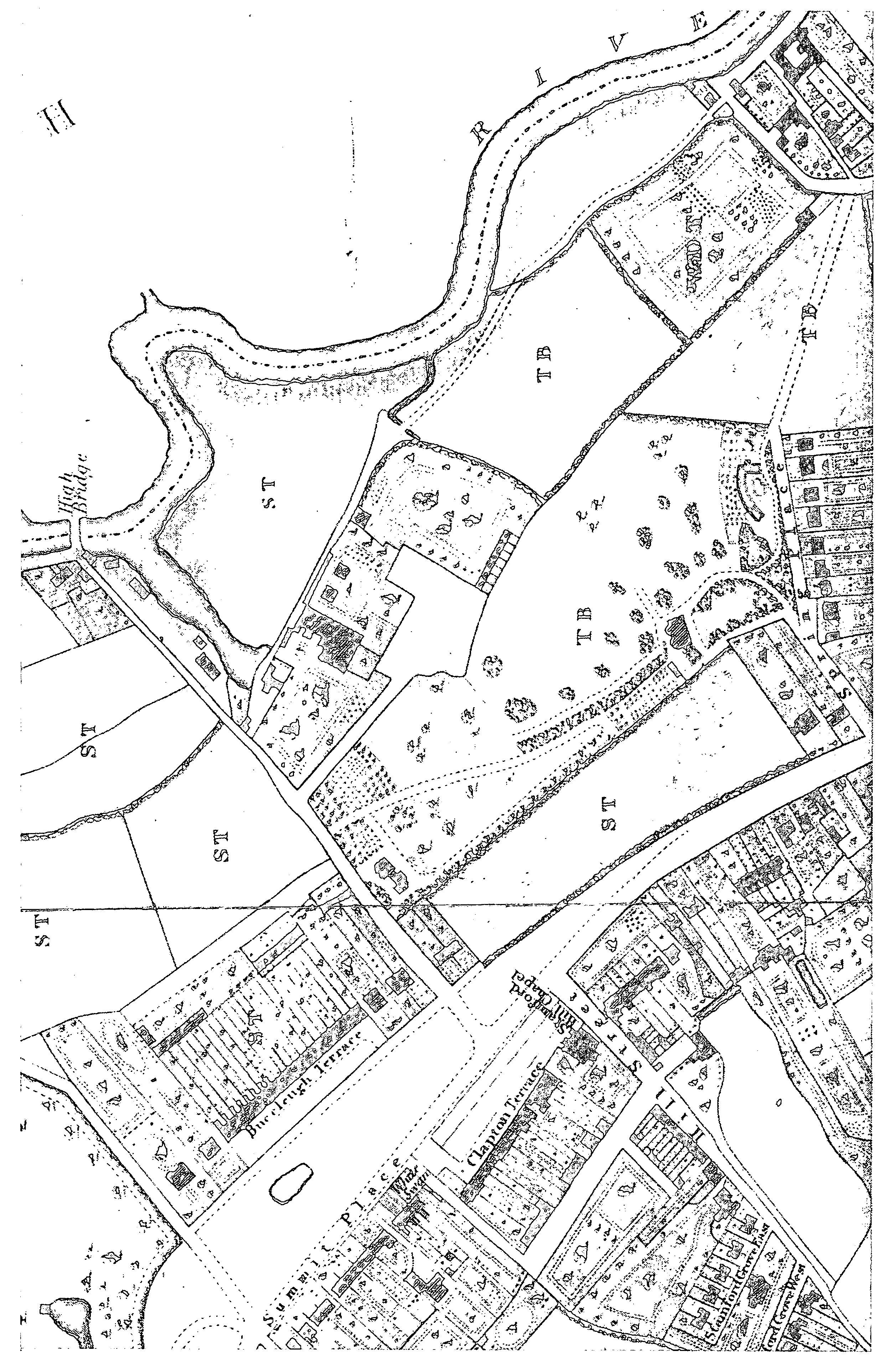
Homerton was recorded from 1343, often as Humberton, and recalled the farm of a woman named Hunburh. (fn. 1) A hamlet (hamella) by 1363, (fn. 2) it grew up north of Hackney brook along an easterly route from Hackney village and Lower Clapton. From what became the east end of the high street (from 1935 styled Homerton High Street), one way continued east across the meadows to the 13th-century Temple Mills and another led south across the brook as Wick Lane (part of it later Sidney, then Kenworthy, Road) to the Templars' manor of Wick. (fn. 3) The area treated here stretches from Chatham Place to the Lea and from the line of Clifden Road southward to Wick Road and the streets immediately south of Retreat Place.
Homerton was the most populous of the parish's six divisions in 1605, with 49 contributors to church rates. (fn. 4) By 1655 headboroughs were appointed for both Upper and Lower Homerton, (fn. 5) and the subdivision was retained for manorial but not for parish government until 1808. (fn. 6) Upper Homerton was the small area around the modern Urswick Road. (fn. 7) It may therefore have been only a part of Great Homerton, recorded as having almost the same number of houses as Little Homerton in 1672. (fn. 8) Benedict Haynes, the holder of Wick manor, in 1605 was assessed under Grove Street (fn. 9) but by 1664 the holder was listed as in Homerton. (fn. 10)
Clapton Common c. 1830
Rich Londoners, numerous in Homerton by c. 1600, had settled much earlier along what by 1551 was called Humberton Street. (fn. 11) An undated timber-framed range, of two storeys beneath its gables, lined the north side from the later Plough Lane to John (from 1909 Banister) Street, opposite a way to where by the 17th century Blew bridge crossed Hackney brook. The range's prominence on maps and the apparent existence of a courtyard behind gave rise to a theory that it had been a manorial seat. More probably it was a royal official's or citizen's retreat before it was divided to include the Plough and several shops, all demolished piecemeal in the 1880s. (fn. 12) Farther east the street extended before 1565 to a large house at the corner of a lane which became Glyn Road. Beyond, at the foot of Marsh Hill, the 17thcentury Tower Place may have been medieval, since it was later depicted with a moat. (fn. 13)
The west end of the street was separated from the north end of Hackney village only by the rectory manor's Church field, through which a path (later Sutton Place) led to the churchyard. (fn. 14) Alfordscroft, 5½ a. between the path and Hackney brook, was conveyed in 1488 by John Broke to his mother's kin William and Margaret Berytell, who conveyed it in 1499 to Thomas Marshall, fishmonger of London, together with the Tanhouse in the south angle of the path and the street. The estate passed in 1508 to William Botry, a mercer, with another house next to the Tanhouse, in 1511 to Sir John Heron, who acquired the rest of Church field, and in 1538 to the diplomatist Sir Ralph Sadler (d. 1587). In 1551 Sadler sold the land, including two houses and a cottage, to John Machell the elder (d. 1558), an alderman of London and once thought to have been the builder of Sutton House. That house in reality was built for Sadler (fn. 15) and named after Thomas Sutton (d. 1611), founder of the London Charterhouse and reputedly England's richest commoner. (fn. 16) Sutton probably lived on the adjacent Tanhouse plot, which the Charterhouse received on his death and retained until the 20th century. Machell's estate passed to Sir James Deane (d. 1608), then to Olive Clarke, and in 1688 from her grandson John Clarke to Sir George Vyner. The house was divided c. 1752: in the 19th century the west half was a boys' and then a girls' school and the east half the home of the vestry clerk Charles Horton Pulley. (fn. 17) The building was bought c. 1890 by the rector, who adapted it as St. John's Institute for young men, and in 1938 by the National Trust. Having stood empty from 1982, proposals for its conversion into flats in 1988 led to the formation of the Sutton House society, which ensured its conservation. (fn. 18)
Nearby, although unidentified, was a freehold house, 'upon the corner of Humberton Street', apparently conveyed in 1595 with property which had been Robert Burgane's to Edward, Lord Zouche (d. 1625). (fn. 19) Zouche cultivated a physic garden, acquired other plots, and was Homerton's most distinguished householder in 1602 (fn. 20) but, despite tradition, (fn. 21) was not buried in the parish church. (fn. 22) His seat was probably conveyed in 1620 by Paul Ambrose Croke to the Master of the Rolls Sir Julius Caesar (d. 1636), a native of Tottenham but resident at Hackney in 1634. (fn. 23)
Other householders in 1605 (fn. 24) were Lord Rich (later earl of Warwick, d. 1619), Lord Cromwell (d. 1607), and Sir John Peyton (d. 1630), governor of Jersey, (fn. 25) who like Zouche were perhaps only occasional residents since they did not contribute to repair of the church. Payments were made by Sir Thomas Leighton, governor of Guernsey, whose son married Zouche's daughter, (fn. 26) Sir James Deane, Sir Edward Holmeden, and Roger Clarke, aldermen, (fn. 27) Sir Marmaduke Wyvell (later a baronet), (fn. 28) and Sir William Hynde.
Homerton's 57 chargeable houses in 1664 included Sarah Freeman's with 22 hearths and Henry Clobery's at Hackney Wick. (fn. 29) In 1672 Great Homerton had 55 houses and Little Homerton 58, together almost a quarter of all those in Hackney. Prominent residents included John Forth, alderman of London, who was charged on 23 hearths in 1672 and sold Lordshold manor in part to (Sir) Thomas Cooke (d. 1695). (fn. 30) Cooke possessed large gardens where expensive improvements were planned in 1691 and which included greenhouses, 2 a. stocked with rabbits, and ponds supplied by pipes. (fn. 31) The precise site of his 'great house', with an access road running north from the west end of the high street, (fn. 32) and the extent of its grounds are unknown. Apparently not a manorial seat, part of the property was bought in 1704 by Richard Ryder (d. 1733), including the later Upton House in Urswick Road, and other houses perhaps in Alderman's Walk (later Homerton Row). Ryder soon made building leases for three plots north of his own house. His family had also built immediately south of the residence by 1717 and was probably responsible for most nearby development north of the high street. (fn. 33)
Homerton had 104 residents who paid poor rates in 1720 and soon had more than any other parochial division, with 155 by 1735 and 213 by 1761, although only 220 in 1779. (fn. 34) There were at least eight taverns in 1725, apart from the White Hart at Temple Mills; they included the Plough, a disorderly house in 1734, the Coach and Horses, perhaps the best appointed since courts baron were held there in the 1750s, and the Greyhound at Marsh gate, the eastern end of the village. (fn. 35) Nine of Hackney's 36 select vestrymen lived at Homerton in 1729 and 7 in 1740. (fn. 36)
In Ram's chapel of 1723 Homerton possessed the parish's first place of Anglican worship to be built after the parish church. (fn. 37) Stephen Ram (d. 1746), a goldsmith, was a manorial constable in 1718 and later an active vestryman. (fn. 38) His chapel was built on a copyhold west of the Plough, which he acquired in 1722 as one of a succession of Londoners, including Charles Booth, a salter, admitted in 1702; by 1704 it contained a new house with 2 a., another house, and four cottages. (fn. 39) The estate passed to Ram's brother Andrew, to Andrew's widow Eleanor, and to John Hopkins, owner of Hackney House. (fn. 40) The chapel had its own trustees from 1775 and later gave rise to a school; building obscured the identity of Ram's own residence, which may have been at the corner of Plough Lane and Homerton Row. (fn. 41)
Edward Brooksby in 1725 bought from John Smith of Hammersmith other property which had been held by Charles Booth. Some of it lay farther east on the north side of the high street, where Booth had acquired lands formerly of Richard Cheney, whose residence had contained 14 hearths in 1664 and 1672. The estate inherited in 1753 by Edward's cousin William Brooksby, a London haberdasher, included four houses in the street, (fn. 42) part of property which he left to his widow Mary and then to Susannah Frames, who in 1805 was admitted with her husband John Musgrove. (fn. 43) Edward also left several houses in Brooksby's Walk, with scattered parcels, to William Frames. (fn. 44) More property, separated in 1706 from some which had passed to Booth, was conveyed by F. J. Tyssen's trustees to William Pratt, a brickmaker, in 1743, when it included eight houses. (fn. 45) Pratt acquired many more sites in or near the high street in the 1740s and 1750s, (fn. 46) all of which passed by will dated 1759 to his wife Jane and on her death by 1772 to their six children. (fn. 47)
In 1745 building was confined mainly to the high street, (fn. 48) although at the west end it stretched along Plough Lane to Homerton Row and south along Bridge Street to Money or Morning Lane. The lane led west past the solitary Old Gravel Pit chapel of 1715-16 (fn. 49) to Hackney village and south-east beside the brook, where it was called Water Lane, to Well Street and so to the London end of Mare Street. By 1697 Bowling Green House had been built south of Morning Lane, from which it was reached by converging ways along the lines of Chatham Place and Meeting House path; it was rebuilt c. 1762 and later called Grove House. (fn. 50) From the high street Shepherd's Lane also led to the brook and had a barn and cottages, three of them new when claimed by Pratt in 1743. (fn. 51) A brewery, presumably by the brook, was owned in 1724 by Thomas Prior and Thomas Marsh, whose property when sold in 1731 included a lease of the White Hart at Clapton. (fn. 52) The south end of Brooksby's Walk existed in 1745 and was so named by 1759, when Pratt left six houses there. (fn. 53) On the south side of the high street the Gill mead estate of the Milborne family included the house leased as a workhouse until its sale in 1769. (fn. 54)
Hackney Wick in 1745 was reached through fields by Wick Lane. Apart from a few cottages where the lane turned east south of the brook, on the site of Silk Mill Row, the hamlet consisted of little more than the spacious Wick House, soon probably rebuilt, and its attendant buildings. (fn. 55)
In 1768 King's Head academy bought copyholds east of the Plough. Development by the academy, from 1823 Homerton College, (fn. 56) and the extension of Brooksby's Walk constituted the main changes in the high street and to the north in the late 18th and early 19th century. (fn. 57) Southwest of the high street more striking changes began with the leasing in 1780 of premises in Shepherd's Lane for Berger's paint factory, which led to the building of cottages around Thomas (later Ribstone) Street on St. Thomas's hospital's land along Water Lane. (fn. 58) To the west was the Woolpack inn, licensed probably by 1760, which gave its name to a brewery later owned by Ford Addison. (fn. 59) Much of the hospital's land was taken for residential housing which merged with that spreading from the south end of Hackney village. In Paradise Place (later the south end of Chatham Place), the New Gravel Pit chapel of 1809 was flanked by Hackney Free and Parochial school from 1811. (fn. 60) Behind, in Retreat Place, Robinson's Retreat was finished in 1813 and two pairs of houses, also designed by Samuel Robinson, were built to the east. (fn. 61) Chatham Place was built up from 1815 and new villas built by John Musgrove formed the east end of Retreat Place in 1824. (fn. 62)
Meanwhile the Charterhouse had built on 1¼ a. containing the remains of an old house, the Tanhouse or its successor, which had served as a school. A terrace of 12 houses was planned in 1796 as the south side of Sutton Place, with mews behind, but finally 16 were built under a lease of 1809 to William Collins, probably one of the family which also took land for the Paragon. (fn. 63) Houses and shops nearby in the high street, Bridge Street, and Morning Lane were leased by Susannah Musgrove in 1822. (fn. 64) In Brooksby's Walk, where her husband John had acquired William Frames's property, the younger John Musgrove made a building lease in 1821. (fn. 65)
The most respectable parts in 1821 were Upper Homerton, (fn. 66) around the later Urswick Road, with 19 merchants or gentry, and Sutton Place, with 15. A few lived nearby in Homerton Row, although most of the 80 householders in its extension Alderman's Walk, which had new cottages, (fn. 67) were tradespeople or labourers; so too were c. 130 in Brooksby's Walk and most of the 79 in 'Homerton', presumably the high street. To the south Homerton Terrace was largely middle-class but Morning Lane with 32 names and Water Lane with 99 were humbler, as were New Cut (later Ball's Buildings and from 1894 Link Street) with 41, Bridge (from 1938 Ponsford) Street with 29, and Shepherd's Lane with 60.
At Hackney Wick, where the White Lion was licensed by 1785, (fn. 68) a snuff mill was acquired c. 1787 for Leny Smith's silk factory. (fn. 69) W. H. Ashpitel held land between Wick Lane and Hackney brook from 1808 and had leased three small sites for building by 1813; c. 25 more cottages, presumably put up by Ashpitel, passed to his sons in 1852. (fn. 70) Leny Smith in 1820 built or refronted 13 cottages, conveyed by his family to trustees in 1827 and to John Musgrove in 1828; (fn. 71) as Silk Mill Row, they stood south of the lane's junction with Cassland Road, which led from Well Street and near whose east end was a row of shanties built from 1806 called Hackney Bay, later nicknamed Botany Bay. Smith also built Sidney House, midway between Hackney Wick and Homerton, in 1808-9. A few buildings stood farther east near the old Wick House in 1831, where Wick Lane turned north towards a rope works and Froggatt's mill. (fn. 72) Smith and Froggatt were among 36 residents, most of them tradespeople or labourers, recorded at Hackney Wick in 1821; a further 76, including many gardeners, were at the Bay and 19 in Baker's Row, also at Hackney Wick. Listed under Homerton, although separated from it by the marsh, were 6 residents at Temple Mills.
Social decline may have started with the expansion of the workhouse, of Berger's factory, and of industry at Hackney Wick. It increased with speculative building and with the construction of the railway from 1847. Victoria Park station served Hackney Wick from 1856, although Homerton had its own station only from 1868. (fn. 73)
South of Retreat Place, small houses by 1843 formed Arthur, Margaret, and Brunswick streets (later Brooksbank and Collent streets and Cresset Road). They had been built by William Bradshaw (d. 1855), an auctioneer also active in Grove Street, (fn. 74) who was responsible for much of Homerton's expansion northward. In 1836 he bought the White House on the east side of Brooksby's Walk and in 1839 Home field on the west, with high street premises and c. 5 a. stretching back to the Grove (from 1907 Homerton Grove). (fn. 75) Part was sold for St. Barnabas's church and its attendant buildings in 1845 and 1847, (fn. 76) when the rest was being covered with cramped terraces: Albert (from 1887 Belshaw and from 1914 Wardle) Street, crossed by Victoria and Brook streets (from 1875 Holmbrook Street), which in 1860 were slums. (fn. 77) To the north-west land behind Homerton College was bought in 1852 by the East London union for a new workhouse and infirmary, under construction in 1854 and enlarged for imbeciles in 1858. (fn. 78)
Expansion southward produced both culs-de-sac and roads which passed under the railway, from Isabella Road in the west to Sidney Road, a renaming of most of Wick Lane (later Kenworthy Road), at the top of Marsh Hill. (fn. 79) The first presumably commemorated Isabella Ball, whose father Robert Hopkins had left 17 copyholds from Sutton House to Bridge Street; she sold some land for the railway and in 1852 her son John Ball broke the entail of the rest. (fn. 80) Church (later Barnabas) Road had been planned as far as Hackney brook in 1849, when building land on either side was held by the auctioneer Marmaduke Matthews and his partner George Horatio Wilkinson, a timber merchant. (fn. 81)
South of the railway, housing by 1865 surrounded the grounds of Sidney House and stretched across the new Wick Road, an eastward route from Water Lane near the line of the culverted brook. Much of the road was built up after 1860 by Matthews and Wilkinson, who had bought some of the bankrupt Leny Smith's property. (fn. 82) Homerton thus reached the suburbs of south Hackney bordering Well Street common and Victoria Park. Housing also spread northward to merge with Lower Clapton. In 1867 the London & Suburban Land & Building Co. was diverting footpaths from the end of Brooksby's Walk, which it was to extend across its Clapton Park estate as Chatsworth Road. (fn. 83) The building of a fever (later the Eastern) hospital along the Grove filled the only large site west of Brooksby's Walk and was said in 1874 to have driven the wealthier inhabitants away. (fn. 84)
Shops lined much of the high street, with seven public houses, and a few had existed in Brooksby's Walk in 1849. By 1872 there were many more, along both sides of Wick Road. (fn. 85) The last private gardens between the high street and the railway, from King's (later Digby) Road to Crozier Terrace, made way for the culs-de-sac of Sedgwick and Nisbet streets (named from 1870). (fn. 86) Infilling south of the high street virtually ended with the expansion of the workhouse and infirmary and of Berger's factory and the building of Ballance Road (named in 1869) and Hassett Road over the grounds of Thomas Ballance's Sidney House. (fn. 87) Vacant plots in Retreat Place were leased in 1874, although the almshouses kept their garden on the north side. (fn. 88) Fields remained only between Homerton and the marsh. The lines of the G.N.R. and G.E.R. divided Hackney Wick, whose focus had shifted eastward to house industrial workers: spaces were being filled between an eastern section of Wick Lane called Gainsborough Road, the railways, and factories served by the Hackney cut. (fn. 89)
Housing spread east of Brooksby's Walk from the 1880s, (fn. 90) along parallel roads leading north: Pratt's Lane, renamed Glyn Road in 1881 and straightened at the high street end, was the longest and had been built up to Lower Clapton's Millfields Road by 1891. Roads to the east had been begun as far as Pincey (from 1905 Daubeney) Road, next to the moated site which still marked the eastern limit of building. South of Marsh Hill there were houses along Sidney Road around a board school of 1882 east to Swinnerton Street, named in 1881 after the Milbornes' heirs, and beside the railway around Bartrip Street, named from 1876. Swinnerton Road replaced the north-west end of Red Path, leading from Marsh Hill to Hackney Wick; the south-east end of the path skirted G.N.R. sidings, next to where the rope works in 1880 was bought to house the Eton mission. (fn. 91) Meanwhile the acquisition of Sidney House as a convent in 1872 had been followed by the establishment of a Roman Catholic school and church where Sidney Road joined Wick Road. (fn. 92) Building joined Homerton to Hackney Wick, where by 1891 the triangle between the G.E.R. line, the cut, and Gainsborough Road had been almost wholly built over.
The high street had no tramways and sometimes appeared too quiet to deserve its name. (fn. 93) Congestion nonetheless led to changes, ranging from a widening of the entrance to Brooksby's Walk in 1876 to rebuilding of the range containing the Plough, where the street was narrowest, c. 1887. The north side of the Grove was to be widened around the junction with Brooksby's Walk in 1884. (fn. 94)
Signs of social decline in the high street included the use of no. 17, where the local benefactor Henry Sedgwick's daughter Marian had lived until 1860, by a pawnbroker's by 1872, the conversion of Upton House into a truant school in 1878, its rebuilding c. 1885, and the acquisition of the early 18th-century Eagle House at the corner of Homerton Row by a dyer; demolitions in Homerton Row c. 1887 were followed by denser building in Halidon Street. (fn. 95) Homerton as a whole was characterized c. 1890 by poverty. The well-to-do were confined to Urswick Road and its western offshoots St. John's Church Road and Sutton Place. Residents nearby were 'comfortable' around and opposite Ram's chapel, in Homerton Row and other streets in the angle with Urswick Road, in Isabella and Mehetabel roads south of Sutton House, and beyond the railway in Chatham Place and Retreat Place; others lived in avenues east of Brooksby's Walk, in Marsh Hill, Sidney Road, and around Hassett Road. The comfortable and the poor were mingled in the central stretch of the high street, the Grove, Brooksby's Walk, south of the railway in Morning Lane (which from 1887 included Water Lane), Digby, Wick, and Ballance roads, and at Hackney Wick in Gainsborough and Windsor (later Berkshire) roads. The poor lived mainly in side streets like College Street (later Row), Durham Grove, and Bradshaw's Margaret Street, the very poor behind the high street around Holmbrook Street to the north and Nisbet and Crozier streets to the south, and off Victoria Road which bisected Hackney Wick. All three of the poorest areas were the only ones in Hackney to contain the lowest, 'semi-criminal' class. (fn. 96)
Hackney Wick, notorious for its jerry building, (fn. 97) was described in 1879 as a district of 6,000 people who had sunk to the lowest depths. (fn. 98) They included many drifters and, being downtrodden, were found by the Salvation Army in 1897-8 to be less violent than those of Bethnal Green; Eton college's mission, despite lavish expenditure, had little moral influence. Houses had been built on layers of refuse, where brickearth had been excavated, and a recent insistence on concrete floors had led to higher rents. Several back-to-back cottages had already been demolished. Infant mortality, although not the general death rate, was the highest in Hackney. (fn. 99)
From the 1890s building continued on the few sites left near the marsh. On the south side of Marsh Hill the former tollhouse, having been a farmstead, made way in 1901 for the completion of Mabley Street, (fn. 100) thereafter the limit of permanent building east of Sidney Road. The moated site north of Marsh Hill was threatened in 1910 by Trehurst Street, started c. 1900 from the Clapton Park end and completed by 1913 along with most of Adley Street to the east. (fn. 101) On the marsh beyond, the first timber works at Homerton bridge existed from c. 1910. (fn. 102) Meanwhile the social standing of Homerton's west end declined further with the rehousing of Hackney parochial infants' school in Isabella Road in 1896, the building of Barlow's tin box factory immediately north of Sutton Place c. 1903, and the conversion of Sutton House into an institute, reopened in 1904, (fn. 103) Upton House's southern neighbour, built by the Ryders and owned from 1847 by the Rivaz family, had been demolished by 1905 for enlargement of the truant school. (fn. 104) Industry spread around Chatham Place: Grove House (no. 36 Chatham Place) became a clothing factory and had lost half of its garden by 1898; the nearby garden of Robinson's Retreat made way for Paragon shoe works in 1912. (fn. 105) William Bradshaw's heirs sold the site of Vine Cottage in the high street for a fire station in 1906; the family sold a block between Holmbrook and Belsham streets and Homerton Grove in 1910 but retained 189 houses in Homerton, including Eagle House, for sale in 1927. (fn. 106)
In the period between the World Wars, Homerton was equally residential and industrial. In 1928 it differed from much of Hackney in that industry occupied purpose-built premises rather than converted dwellings. Tranby Place in the high street east of Brooksby's walk had been cleared and six factories had replaced houses north of Sutton Place. Hackney Wick also had purpose-built factories, mainly along the canal and older than the cheap terraces housing their workers. (fn. 107) Nisbet Street and parts of Hackney Wick were still the poorest areas in 1930. (fn. 108)
The built-up area spread only to the northeast, where in 1937 the L.C.C. took part of Hackney marsh for the Kingsmead estate. With 17 five-storeyed blocks, a school, and shops, it extended building from Adley Street to the factories at Homerton bridge. (fn. 109) Off the high street Hackney M.B. replaced slums behind the old Plough range, in Homerton Row and College Street, with 160 flats in Banister House, opened in 1935. (fn. 110) Clearances were also ordered for Nisbet Street in 1934, the south end of Bridge Street and part of Morning Lane in 1936, and Rosina Street in 1937. (fn. 111) Six-storeyed blocks forming Nisbet House, with 311 flats, were opened by Hackney in 1938. (fn. 112) Cramped rows off Morning Lane had made way by 1940 for Woolpack House and Ribstone House, the first blocks to form the north part of the L.C.C.'s Morningside estate. Beyond Retreat Place, streets were renamed between 1936 and 1938 and partly rebuilt; Lennox House had been built in Cresset Road by 1938. (fn. 113) Among buildings demolished were the 18th-century Grove House, empty since 1912, in 1921 and Ram's chapel, to widen the high street. (fn. 114) Longer streets to be renamed were Church Road, called Barnabas Road from 1936, and Sidney Road, called Kenworthy Road from 1938.
War damage led to an increase in public housing. (fn. 115) Demolitions included Homerton College for an extension of Banister House, with a further 235 flats by 1960, (fn. 116) and Robinson's Retreat for part of the Morningside estate, including Cresset House and Brooksbank House which by 1952 stretched south to Cresset Road. Building on the north part of the estate, where more blocks had been named early in the war, continued before and after 1950.
In 1960 Berger's factory closed, (fn. 117) whereupon almost the entire area south of the railway between Morning Lane and Barnabas Road was cleared for the L.C.C.'s Wyke estate. Early flats included Baycliffe House and Risley House in Digby Road from 1959 and Musgrove House in Barnabas Road from 1960. Nearby the L.C.C.'s Gascoyne estate, extending into south Hackney, included the ten-storeyed Kingscroft Point, finished in 1967, and Heathcote, Vanner, and Ravenscroft points of 1968, all system-built and soon reinforced. In Berger Road, Latimer House and Gilby House were built as part of the Wyke estate c. 1982. (fn. 118)
Changes in Homerton High Street included the demolition of Eagle House in the early 1950s and of buildings to the east. (fn. 119) Hackney M.B.'s six-storeyed block of 75 flats called Marian Court (fn. 120) stood west of Ponsford Street by 1960 and the similar Bridge House to the east, opposite Banister House, by 1967. Priory Court had been built in Brooksby's Walk by 1970. The high street, as a shopping centre never a rival to Hackney village or Dalston, was characterized by such public buildings as the fire station and library, both Edwardian but rebuilt in 1974, and the gaunt piles of the extended workhouse which served as Hackney hospital. (fn. 121) Many terraces remained in Glyn Road and its neighbours east of Brooksby's Walk, but flats bordered Marsh Hill at Humberton Close and Newbury Court by 1980 and at Studley Close by 1985. Although Metal Box and other firms left, industry survived near the railway and in 1985 Homerton station was reopened. (fn. 122)
At Hackney Wick, which had public baths from 1935 and a library from 1947, (fn. 123) changes were more sweeping. South-west of the baths, the L.C.C.'s Eastway Park had been opened by 1960 as an old people's home. Opposite, between Eastway and the factories along the railway and the cut, the G.L.C.'s Trowbridge estate left only the north-south line of Osborne and Prince Edward roads from the centre of the old street pattern. First opened in 1965 and completed in 1969, the estate included 117 bungalow homes but was most striking for its seven 21-storeyed towers, (fn. 124) with mosaic facings and glass balconies.
The railway's division of Hackney Wick was reinforced from the 1970s by the partly sunken Cowdry Road and the elevated East Cross motorway. Construction of the East Cross route involved the demolition of Hackney Wick station, which had been closed since 1943, although a new station in Chapman Road was opened in 1980. (fn. 125) Plans to redevelop the Trowbridge estate were modified in 1987, after only three of the tower blocks had been demolished. (fn. 126)
In 1992 the railway sidings had made way for low-rise housing at Edmeston Close, still to be reached from Eastway along Red Path, which crossed Cowdry Road. Between Berkshire Road and the cut three-storeyed ranges formed Leabank Square, which was partly occupied. The only long terrace from late 19th-century Hackney Wick survived, partly neglected, north-east of the former baths as nos. 61-79 (consecutive) Eastway.
From the cut, Homerton Road and Eastway led straight between recreation grounds towards Temple Mills bridge. A few large factories stood near the end of Eastway and others bordered Waterden Road, which ran north to a busy intersection west of the bridge. (fn. 127) Where Temple Mills Road crossed the Lea, past the site of the mill and its cottages, a rebuilt successor to the White Hart stood empty. Nearby was the entrance to Lee Valley park authority's Eastway sports centre, beyond the boundary. (fn. 128)
Homerton has few pre-Victorian relics, apart from Sutton House, and Hackney Wick has none. The district is one of housing estates, factories, and small businesses. Apart from cleared sites west of Brooksby's Walk, there are spaces for recreation only where building gives way to Hackney marsh.
Homerton High Street is ill served by shops, although a few lie east of Brooksby's Walk. The dominance of municipal flats is relieved chiefly by St. Barnabas's church, (fn. 129) its churchyard, and attendant ragstone buildings. A few town houses remain on the south side of the street. No. 168, of three storeys over a basement and with a Tuscan doorcase, is the better preserved of a mid to late 18th-century pair, no. 170 having a warehouse covering its ground floor. (fn. 130) Nos. 140 and 142, east of Digby Road, have Tuscan doorcases and are probably early 19th-century. (fn. 131)
The gentility of Upper Homerton is recalled by Sutton Place, since 1969 part of the conservation area around Hackney church. (fn. 132) The south side, nos. 1-16, is a stock-brick terrace of three storeys over basements, nos. 1 and 2 having added mansards with dormers; details include pilastered doorcases, fanlights, and first-floor iron balconies. (fn. 133) The range was built under a lease of 1809, possibly to the design of the Charterhouse surveyor William Pilkington, who had been concerned with earlier plans, and forms a group with nos. 1-22 on the north side. (fn. 134)
Sutton House, to the south-east, is Hackney's oldest domestic building and one of the few urban properties of the National Trust. (fn. 135) Threestoreyed and built of brick on an H plan for Sir Ralph Sadler in the 1530s, Sutton House retains some of its original exterior diaper brickwork and of its early decoration and fittings. Fragments of painted decoration survive in the north-west room, the parlour, and there is 16th-century panelling in that room and in the large central room on the first floor. Only one original window, of six lights with a single transom, survives. The staircase in the west wing is 17th-century. The eastern range housed the kitchen and service rooms. Its cellar was probably approached by an internal stair, whereas that under the west wing had an external stair. The house was divided into two dwellings c. 1752, when the central range was refaced and given sash windows and a second doorway, and sash windows were put into the fronts of the wings. The subdivision of the hall, and panelling and the staircase in the east wing, probably date from that time. The east wing was rendered in the later 19th century when there was some interior remodelling. Additions to the south culminated in a large meeting room, the Wenlock Barn, of 1904. Restoration, begun in 1990, has aimed to display the Tudor house in its undivided state while adapting the additions of c. 1904 for use by the community. The building was reopened to the public in 1992. (fn. 136)
Towards Hackney Wick, the former Sidney House survives as the north wing of the Sacred Heart convent. It is almost hidden by later buildings and is a brick villa of c. 1800, of five bays and three storeys beneath a stuccoed cornice and a mansard roof with dormers. (fn. 137) Housing of 1959-60 on the Wyke estate has been praised, both for the framework of low terraces around the towers and for landscaping. (fn. 138)