A History of the County of Middlesex: Volume 11, Stepney, Bethnal Green. Originally published by Victoria County History, London, 1998.
This free content was digitised by double rekeying. All rights reserved.
'Stepney: Early Stepney', in A History of the County of Middlesex: Volume 11, Stepney, Bethnal Green, ed. T F T Baker (London, 1998), British History Online https://www.british-history.ac.uk/vch/middx/vol11/pp1-7 [accessed 30 April 2025].
'Stepney: Early Stepney', in A History of the County of Middlesex: Volume 11, Stepney, Bethnal Green. Edited by T F T Baker (London, 1998), British History Online, accessed April 30, 2025, https://www.british-history.ac.uk/vch/middx/vol11/pp1-7.
"Stepney: Early Stepney". A History of the County of Middlesex: Volume 11, Stepney, Bethnal Green. Ed. T F T Baker (London, 1998), British History Online. Web. 30 April 2025. https://www.british-history.ac.uk/vch/middx/vol11/pp1-7.
EARLY STEPNEY
Stepney covered almost all the area between the suburbs of the City of London and the river Lea, the eastern boundary of Middlesex, until the early 14th century when the first of several daughter parishes was created. Partly built up in the Middle Ages and great in size, it served many economic functions, with contrasting social conditions, over a long period. A maritime parish with the associated activities and docks, Stepney was also closely involved in London's economy, especially in housing the latter's industries. The western part provided the first English home for generations of immigrants, while farther east it was largely suburban in character. (fn. 1)
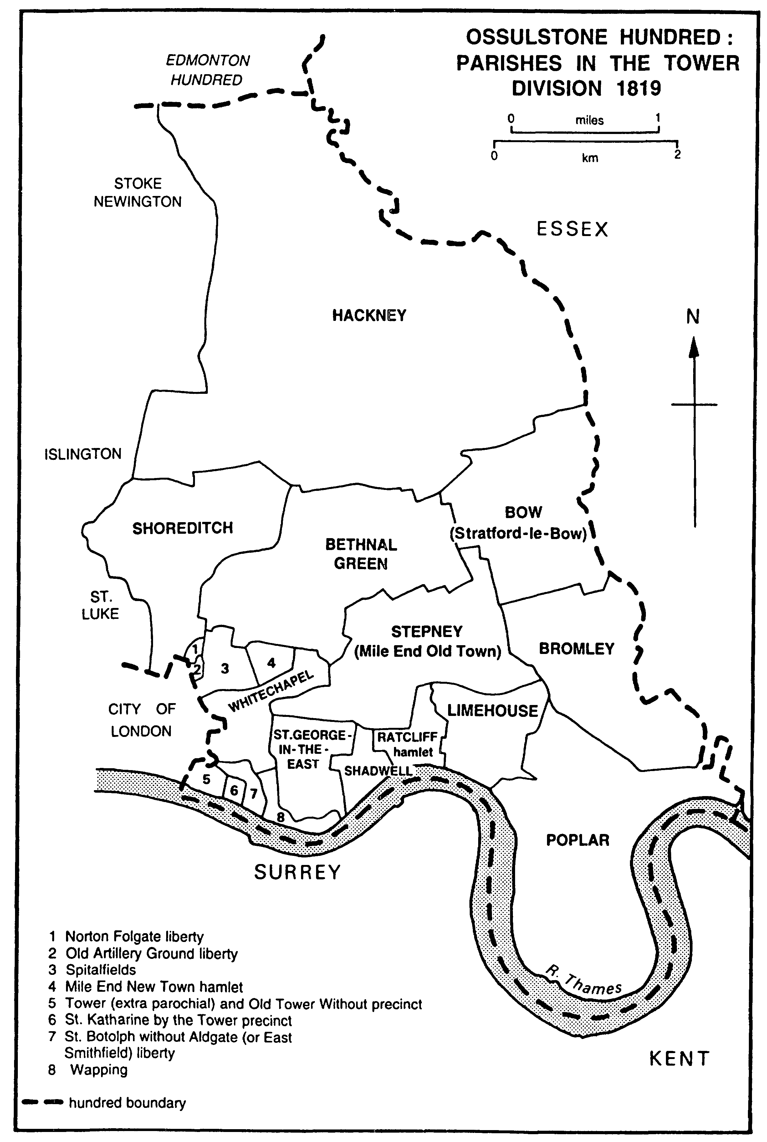
OSSULSTONE HUNDRED : PARISHES IN THE TOWER DIVISION 1819
The parochial jurisdiction devolved from the much larger vill of Stepney belonging to the bishop of London and covering east, north-east, and part of north London. (fn. 2) The vill included Hackney, and probably at one time also Bromley, a parish created from an estate in 'Stepney' claimed unsuccessfully by the bishop in 1086. (fn. 3) The date at which the three achieved separate parochial status is not known: since Stepney gave its name to the vill it is assumed it was a Saxon parochia, (fn. 4) but on the other hand, because of its closeness to London it may have remained part of the parochia of St. Paul's until relatively late.
Stepney's boundaries were first delineated in 1703: (fn. 5) to the south was the Thames, to the east Bromley and, across the Lea, West Ham (Essex), to the north Hackney, and to the north-west Shoreditch. To the west the City of London's suburban wards of Bishopsgate Without and Portsoken formed the parishes of St. Botolph without Bishopsgate and St. Botolph without Aldgate respectively; the second also included the precinct of St. Katharine by the Tower and East Smithfield.
The ancient parish included the hamlets of Mile End Old Town, Mile End New Town, and Ratcliff, which remained part of St. Dunstan's, Stepney, and the following hamlets which became separate parishes: Whitechapel, including part of Wapping called Wapping-Whitechapel which became the parish of St. John, Wapping; Stratford Bow, including Old Ford; Shadwell; the major part of Wapping called Wapping-Stepney, which became the parish of St. George-in-the-East; Spitalfields; Bethnal Green; Limehouse; Poplar, which included the Isle of Dogs and its settlements of Blackwall, Millwall, and Cubitt Town.
Under the London Government Act, 1899, the separate parishes were brought together in three M.B.s: Bethnal Green, coterminous with its parish; Poplar, including Stratford Bow and Bromley; and Stepney, including all the remaining parishes, East Smithfield, and the small liberties along the western boundary of Stepney - the liberty of the Tower, by the river, Holy Trinity (formerly the precinct of the Minoresses' abbey of St. Clare), just north of the Tower, and Old Artillery Ground and Norton Folgate, both near Bishopsgate. (fn. 6)
Stepney's land boundaries were not natural: that with Bromley followed the bounds of an estate given with the foundation of St. Leonard's priory, and a small area of meadow on the east side of the Lea lay in Stepney. Part of the boundary with Shoreditch followed a highway from Shoreditch church to Cambridge Heath; most of the western boundary presumably represented the limits reached by Londoners' jurisdiction. The boundary with Hackney cut across fields in 1703, suggesting that it was laid down when that part of the manorial demesne was unassarted, probably woodland, and before any man-made features were available. (fn. 7)
At its greatest extent Stepney parish covered c. 4,150 a. (1,679.5 ha.), including land wrested from the Thames. (fn. 8) By 1320 it had lost c. 211 a. to form the parish of St. Mary Matfelon or Whitechapel, (fn. 9) whose boundaries seem to have followed those of fields or estates, apart possibly from the line along Back Church Lane, which may have been the medieval Chapel Street. The new parish took the western side of Stepney extending from the property and waste lining the north side of the Colchester road southward to the Thames, with an extension eastward along the Colchester road and the waste on either side as far as Mile End, probably to share responsibility for that important highway. Whitechapel may have ended at the river where the Crash mills stood, but by the 16th century it included a narrow tongue of reclaimed land running eastward between Wapping's medieval river wall and the low-water mark and known as Wapping-Whitechapel; it almost completely cut off from the Thames the rest of Wapping, which remained part of Stepney and was distinguished as Wapping-Stepney. (fn. 10) Wapping-Whitechapel became the separate parish of St. John, Wapping, in 1694. (fn. 11)
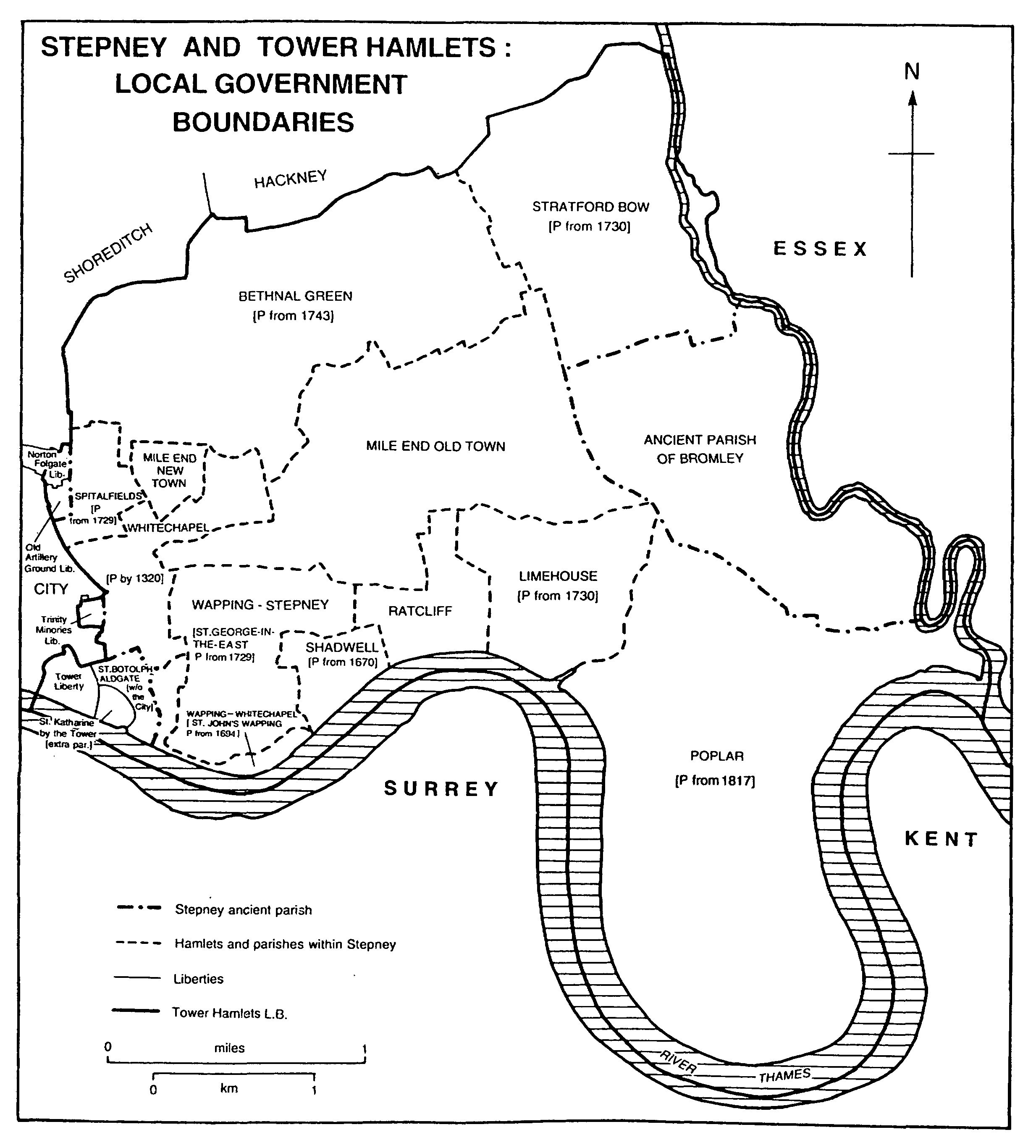
STEPNEY AND TOWER HAMLETS : LOCAL GOVERNMENT BOUNDARIES
Later parishes were formed from the hamlets whose boundaries had been settled by the late 17th century. (fn. 12) St. Paul, Shadwell (68 a.), was created by an Act in 1670. (fn. 13) Christ Church, Spitalfields (73 a.), and St. George-in-the-East (formerly WappingStepney) (244 a.) followed in 1729, St. Mary, Stratford Bow (565 a.), and St. Anne, Limehouse (244 a.), in 1730, and St. Matthew, Bethnal Green (755 a.) in 1743. (fn. 14) The last new civil parish was All Saints, Poplar (1,158 a.), in 1817. (fn. 15) There remained three hamlets totalling 830 a. (335.9 ha.) in the parish of St. Dunstan, Stepney: Mile End Old Town (677 a.), Mile End New Town (42 a.), and Ratcliff (111 a.).
Though most of the ancient parish lies on River Terrace high flood plain gravel on top of London Clay, the area north-west of a line from the north-west corner of Victoria Park to the south-west corner of Bethnal Green parish consists of brickearth, patches of which also overlie the gravel elsewhere. (fn. 16) The gravel ends just short of the Lea, which runs through a valley of alluvium lying over London Clay, which provided an important area of meadows and grazing. (fn. 17) In the south part of the parish the gravel ends at a line which runs from the northern half of St. Katharine's docks, north of the London docks, to the junction of Cable Street and Butcher Row, then continues to the southern end of West India Dock Road, along Poplar High Street, and then to the north-west corner of the East India docks. The edge of the gravel formed a steep bank in Wapping and Shadwell, called the Linches from the 12th century; it had been the site of a Roman road and was later that of Ratcliff Highway. (fn. 18) Along the Thames an alluvial belt, joining the alluvium of the Lea valley, includes the whole of the Isle of Dogs, the land around the Limehouse basin, and the southern parts of St. George-inthe-East and Whitechapel, lying on London Clay or on Woolwich and Reading Beds.
All the parish, save the western part of Bethnal Green and a patch near the west end of Commercial Road, lies at less than 15 m. above sea level; the riverside and the south-east parts lie at less than 10 m. (fn. 19) Deposits since Roman times have added to the Neolithic alluvium along the Thames, where much of the land may have been submerged at high tide as late as the 2nd century A.D. (fn. 20) By the 12th century those areas were known as marshes, the most important being Walmarsh or Wapping marsh, in St. George-in-the-East and Whitechapel, and Stepney marsh or Poplar marsh, in the Isle of Dogs. (fn. 21) The extent of the alluvial marsh may explain why a landing-place, the Stybba's hythe which evolved as 'Stepney', gave its name to a large area of Middlesex: (fn. 22) the only place on the north bank below London where the river approaches the gravel ridge to make landing feasible is at Ratcliff Cross, where Butcher Row meets Ratcliff Highway, and in the 1st century A.D. the bank may even have been farther north, possibly as far as Cable Street. (fn. 23)
The marshes provided sites for medieval tidal mills. (fn. 24) By the early 13th century embanking and drainage had created much cultivated land: arable adjoined the river wall at Wapping that gave its name to Walmarsh. (fn. 25) An inquiry in 1324 on the area between St. Katharine's marsh and the vill of Shadwell (that is, Walmarsh) found that an unknown lord of Stepney in 'ancient time' had recovered about 100 a. with banks and ditches; when they had fallen into disrepair he had granted 42½ a. to freemen and the rest to his bondmen, all of whom held by the service of maintaining the river walls and sewers under the supervision of two wall-reeves answerable to the manor court. The measure had worked well, except when bad weather or exceptionally high tides had left the tenants in need of financial help. (fn. 26) A tenement near Limehouse called the Mote had a similar obligation to repair river walls. (fn. 27)
The high tidal range made necessary repeated reclamation work until adequate embanking was carried out in the 16th century. The Crown often appointed commissions to inspect and repair stretches of riverbank from the City eastward, occasionally well into Essex. The earliest commission known was in 1297-8; another was named in 1324 after major flooding, and they later became frequent, with nine between 1354 and 1381, and five between 1395 and 1407. In 1395-6 the lord lost rents from submerged land and the manor paid expenses for attending the inquiries at Whitechapel into repair of walls. (fn. 28) In 1429 ordinances were to be made for Stepney and Walmarsh similar to the laws and customs of Romney marsh, in order to obtain labourers and make quick repairs. A similar commission was appointed in 1447 for land as far north as the parish churches of Bromley, Stepney, and Whitechapel, but floods in 1448 led to an inquiry into the cause. Further commissions were held in 1455, 1467, 1474, and 1480. (fn. 29) The large number of freeholders, whom the manor court could not easily coerce, probably accounted for presentations in the king's courts, as in 1369-70, when landholders were summoned to repair their stretches of wall. (fn. 30)
Flooding in Stepney or Poplar marsh hastened the transition from arable to pasture in the 15th century and saw the abandonment of a settlement at the south end of the Isle of Dogs. (fn. 31) In 1448 a major breach in the wall on the south-west of the marsh through neglect by the freeholder John Harpur, presumably as lord of the manor of Pomfret, was said to have allowed the flooding of c. 1,000 a. (fn. 32) Sixteen years later 400 a. of Stepney manor were still flooded, causing loss of revenue to the bishop, of 7 tenements and 9 cottages to his tenants, and of land on other manors. (fn. 33)
More permanent solutions were found in the 16th century: after the whole of Wapping marsh had been flooded, building was encouraged on top of the wall c. 1570, the site of the roads called Greenbank and Wapping Wall, and gradual enwharving on the river side helped to contain the tides. (fn. 34) Statutory commissions for sewers in the 16th and 17th centuries for all the areas around London provided closer supervision and spread the financial burden more widely. (fn. 35)
A watercourse, probably rising near Spitalfields, ran south-eastward through Haresmarsh to Mile End, crossing the Colchester road near the junction with Cambridge Heath Road, passing north of the parish church, and curving round into Poplar to enter the Thames at Limehouse dock. It may have given the name to Brokestreet, near the church, by the 14th century. (fn. 36) In 1703 it crossed the Colchester road by a bridge, known as Stonebridge in 1731. (fn. 37) The stream was gradually culverted and by the late 18th century, when it was known as the Black Ditch, was clearly distinguished only between Rhodeswell Road and the Thames. Long straight stretches suggest that its course had already been modified. (fn. 38)
Other watercourses may have been small streams running into the Thames but later dug out for drainage. The 13th-century Cropats ditch near Cropats well, south of Hachestreet (later Cable Street), (fn. 39) was possibly the stream that ran along Nightingale Lane to the Crash mills. Although a 16th-century plan shows it running from East Smithfield, it was more likely to have risen in Wellclose Square. (fn. 40) Another stream rose in the gravel near Shadwell well, by the site of St. Paul's Shadwell, and was still known to residents in 1684. (fn. 41) A stream c. 12 ft. wide that existed by the 12th century formerly skirted the road at the eastern junction of Butcher Row with White Horse and Cable streets. It probably flowed from north-east to south-west, but has not been traced to the Thames. (fn. 42)
In the 20th century a concealed stream arose at the junction of Devons Road and Weston Street, in Bromley, and ran erratically southward to cross Poplar High Street and then turn eastward through the workhouse to Poplar dock. The only other known 20th-century stream (also concealed) rose at the junction of West and South Tenter streets in Goodman's Fields, in Whitechapel, and ran south to the Thames at Tower Bridge. (fn. 43)