A History of the County of Middlesex: Volume 11, Stepney, Bethnal Green. Originally published by Victoria County History, London, 1998.
This free content was digitised by double rekeying. All rights reserved.
'Stepney: Communications', in A History of the County of Middlesex: Volume 11, Stepney, Bethnal Green, ed. T F T Baker (London, 1998), British History Online https://www.british-history.ac.uk/vch/middx/vol11/pp7-13 [accessed 30 April 2025].
'Stepney: Communications', in A History of the County of Middlesex: Volume 11, Stepney, Bethnal Green. Edited by T F T Baker (London, 1998), British History Online, accessed April 30, 2025, https://www.british-history.ac.uk/vch/middx/vol11/pp7-13.
"Stepney: Communications". A History of the County of Middlesex: Volume 11, Stepney, Bethnal Green. Ed. T F T Baker (London, 1998), British History Online. Web. 30 April 2025. https://www.british-history.ac.uk/vch/middx/vol11/pp7-13.
In this section
COMMUNICATIONS
ROADS.
Roman and pre-Roman roads are still largely conjectural. (fn. 1) An Iron-Age route linking the Trinobantes' capital at Colchester with a Thames crossing is thought to have run through Stepney and been rebuilt by the Romans. It forded the Lea and continued west of Stepney along the line of Old Street. (fn. 2) Despite the discovery of a section of Roman road, unaligned, at the junction of Green Street (renamed Roman Road) and Cambridge Road in 1938, (fn. 3) the most likely route to Old Street is that of Hackney Road, the parish boundary and therefore probably ancient. (fn. 4)
The ford is assumed to have lain at Old Ford opposite Iceland wharf, where Roman tiling was found in 1905. (fn. 5) It is also assumed to have been the crossing-point for the road to Colchester from London by way of Aldgate, (fn. 6) since a three-track highway, built soon after the Claudian invasion, has been uncovered a few hundred yards to the west. The south track may have remained in use until soon after 400 A.D. (fn. 7) Extrapolation in a straight line suggests that it was the Aldgate-Colchester road, (fn. 8) although it would have run only a few hundred yards south of the road at Green Street. (fn. 9)
There is little evidence from 1703 for the route, (fn. 10) nor as to when or why it was changed to its later line, to cross the Lea at Stratford Bow. In 1302 it was found that the bridges at Bow had been built at the instruction (between 1100 and 1118) of Maud, wife of Henry I, to replace a dangerous ford which the jurors assumed to have been at Old Ford, a name recorded in 1230. (fn. 11) The road itself was not mentioned; it may have been realigned when the bridges were built, although if it still ran to Old Ford the bridges would probably have been built there. Excavations near Old Ford have found no evidence for the use of that road after the early 5th century. (fn. 12) The modern road forms part of the northern boundary of Bromley parish, created from a manor in existence by 1066, and so is likely to have been in use by then. Its straightness between Aldgate and the junction with the Romford road in West Ham indicates a Roman origin. The name Stratford given to the settlements on both the Middlesex and Essex sides (Stratford Langthorn), in conjunction with the name Old Ford, suggests the existence of two fords and of a metalled road in use with a ford well before the bridge. (fn. 13)
STEPNEY COMMUNICATION
Further signs of the antiquity of the modern Colchester road, with stretches known as Aldgate High Street, Whitechapel High Street, Whitechapel Road, Mile End Road, and Bow Road, date from the Middle Ages. Like the Cambridge road from Mile End to Hackney, and the road from Mile End to Stepney church, the Colchester road ran between wide bands of manorial waste that possibly stretched from Aldgate bars into the hamlet of Stratford Bow. Free and copyhold messuages along the edge of the waste where it adjoined the cultivated fields suggest that the road pre-dated the fields. The antiquity of the part nearest Aldgate was confirmed by Roman metalling found below Aldgate High Street, (fn. 14) and the medieval name for Whitechapel High Street was Algatestrete. (fn. 15)
Other main routes are also uncertain before the 13th century. London's wall of 200 A.D. may have had a gate, St. Peter's gate, to a road along the gravel ridge to a signal station on the south side of Ratcliff Highway at the junction with Gravel (later Old Gravel, then Wapping) Lane. Romano-British burials took place farther east near the junction of Ratcliff Highway and Love Lane, whence the road may have continued as far as Ratcliff Cross to a likely landing-place. (fn. 16) A Roman road running south-east, across the site of the Minoresses' convent, was aligned on Hart Street in the City and thus probably older than the wall; its destination is not known (fn. 17) but may have been the signal station.
From c. 1200 the evidence for south-western Stepney is firmer. Slightly north of the Tower a postern gate was made in the wall, from which two roads ran eastward. That called Hachestreet by 1250 (fn. 18) had become Heggestreet or Hoggestreet in the 14th century, Hog Lane by 1542, (fn. 19) and Rosemary Lane by 1637. (fn. 20) It reached White Horse Street, Ratcliff, probably by the 13th century and certainly by c. 1577. (fn. 21) The part through Wapping was known as Cable Street by 1703, (fn. 22) and that nearest to Ratcliff as Brook Street by 1652. (fn. 23)
South-east of the postern was the settlement of East Smithfield, where a road ran parallel to Hachestreet. Called the 'vicum de Shadwell' in 1272 (fn. 24) or Shadwell Street, later Ratcliff Highway, it lay almost on the southern edge of the firm gravel, and from its name and nearby remains was probably of Roman origin. It existed by the early 13th century and probably in the 11th, as it gave access to Shadwell and Wapping mills, (fn. 25) and in 1362 was referred to as the highway between the Redclyf and the Tower of London. (fn. 26) Wapping mill was probably reached by the road running south from Ratcliff Highway and later known as Wapping Lane. Since the holder of the mill paid a service to the bishop of London c. 1270 for a way from Wapping to Stepney, it was not an ancient right of way. (fn. 27)
Other main routes led off the Colchester road. The later Cambridge Heath Road left it a mile from Aldgate pump and ran northward to Hackney; Bethnal green and Cambridge Heath were parts of the waste along its length. (fn. 28) The junction became known as Mile End and later marked the eastern extremity of Whitechapel parish.
A little to the east of Mile End a road branched off towards the parish church. In 1725 an ancient highway called Mile End Green leading from the hamlet of Ratcliff to the City, (fn. 29) it was later renamed Stepney Green. It continued through Ratcliff linking Stepney church, White Horse Street, and Butcher Row to Ratcliff Cross and the river, and probably was at least as old as the church. Late 14th-century settlements along it were called Churchstreet (west of the churchyard), Spilmanstreet, Clevestreet, and Redclyff. (fn. 30) Brokestreet, near the church but unlocated, may have been the lane on the east side of the churchyard, or the road beside a stream north of the church (later Ben Jonson Road) leading towards Rogueswell common. (fn. 31) By 1577 the road south of the churchyard was called White Horse or White Hart Street, after the White Hart near the junction with Rose Lane. (fn. 32)
Opposite the White Hart a road ran northwest to join Whitechapel Road by the church there. In the 18th century it was known as White Horse Lane, (fn. 33) having been known in 1459 as the path or road from the church of St. Mary Matfelon to Ratcliff. (fn. 34) Three roads ran eastward from Ratcliff to Limehouse, Poplar, and Blackwall by the late 16th century. The most northerly, Salmon's Lane in 1652, was a public highway to Ballscross in 1454 and the road from Stepney church to Limehouse in 1577. (fn. 35) Another, Rose Lane in 1703, was the highway from the White Hart to Poplar in 1484 and the Back Lane from Limehouse to White Horse Street in 1652. (fn. 36) Both Salmon and Rose lanes, referred to as routes to Blackwall in 1615, (fn. 37) joined a lane from Ballscross to Limehouse, known in the 14th century as Forby Street or Forby Lane and in 1652 as Three Colt Street or Forbes Street. (fn. 38) The southernmost route ran eastward from Ratcliff Cross to Limehouse, and may have been the highway between Ratcliff and Limehouse mentioned in 1440. (fn. 39) It was lined with waste which was let for building by Lord Wentworth in the late 16th century, that on the south side being valuable for riverside wharves. In 1652 it was called Limehouse Street, and in the 1740s the Narrow Street, later the Narrow Way. (fn. 40)
From Limehouse the route to Blackwall lay along Poplar High Street, another area of medieval settlement. (fn. 41) Roads ran from the street northward to Bow bridge and Bromley, and southward to a ferry at the southern end of the Isle of Dogs. These routes were probably that of Edward I from Pomfret manor in the Isle of Dogs to Stratford Bow, and of James I from his favourite palace at Theobalds (Herts.) to Greenwich. (fn. 42) In 1652 the road to the ferry was known as Chapel Lane. (fn. 43)
The medieval road pattern changed little until the 19th century. Mile End Road, as an important highway to Essex, required much mending: John Hadley, a prominent local landowner, left £10 towards repairs in 1409. (fn. 44) The parish was reported as neglectful of its highways in 1637. (fn. 45) In 1696 it was stated that the road had been improved 30 years earlier under pressure from the Lieutenant of the Tower, by timbers covered with earth and gravel with a higher row of large gravel packed into the middle to throw water off into the ditches on each side. (fn. 46) Despite building on the waste, the Colchester road and its two offshoots retained wide carriageways and open ground either side, which still gave them a distinctive character in 1994.
The London-Harwich road was turnpiked between Whitechapel and Shenfield (Essex) under Acts of 1722 and 1737, with each hamlet contributing proportionately. (fn. 47) The only turnpike gate in Stepney until the 1820s, Mile End Gate, allegedly was erected in 1714, (fn. 48) but presumably was built in connexion with tolls for mending the road under the Acts. It stood just west of the junction with Cambridge Road and was long survived by its name, in 1994 that of a bus terminal. In 1809 a parliamentary committee reported that the whole road should be paved in the centre but that any unbuilt verges should be left for driven animals. (fn. 49)
Roads were improved for access to the East and West India docks in the 19th century. White Horse Lane became Commercial Road East, authorized in 1802, which continued eastward to join East India Dock Road by 1825. (fn. 50) Minor improvements to main routes throughout the parish were made by the M.B.W. after 1855. (fn. 51) More significant was the East Cross route, a motorway completed in 1979 linking Hackney Wick with the Blackwall tunnel, (fn. 52) which absorbed parts of several local roads in Stratford Bow and Bromley and created a barrier down the middle of both parishes. In the 1980s roads to and within the Isle of Dogs were altered to improve access and allow new building around the docks. (fn. 53)
Transport from Blackwall to the City was heavy in 1825, with 29 short-stage coaches making 72 return journeys a day, including coaches run by the West India Docks Co. to carry passengers and samples of goods. Bow and Bromley was the terminus for two coaches making five return journeys a day. (fn. 54) In 1838-9 licensed services again reflected the importance of the docks. From Blackwall four short-stage coaches and one omnibus ran to the City, 23 omnibuses ran to Piccadilly, 10 to Sloane Street, and five to Edgware Road. There were also nine short-stage coaches running from the East or West India docks to the City. Other services ran along the Mile End Road: seven omnibuses ran from Bow to Oxford Street and Hyde Park Corner. From Mile End Gate, 27 omnibuses ran to Chelsea, 10 to Bond Street and Oxford Street, 8 to Notting Hill, 2 to Hammersmith and 1 to Fulham. From Whitechapel church three omnibuses ran to Hammersmith Gate, and one to Chelsea. Four operators each ran a short-stage coach from south of the Thames (Brixton Hill, Herne Hill, Sydenham) to Bow church. The parish was also served by vehicles starting in Romford or in Hackney. (fn. 55)
The North Metropolitan Tramways Co. opened a service along Mile End Road between Whitechapel church and Bow church in 1870, offering cheap early-morning fares for workmen. The line carried over a million passengers in the first six months and was extended into Essex and westward to Aldgate High Street in 1871. The company opened a line from the East India docks to Aldgate in 1872, and one from South Hackney along Burdett Road to Limehouse in 1879, with a spur to West India docks in 1885. In addition to early-morning fares, it introduced all-day 1d. fares in 1891 on special trams from Aldgate to Poplar and Stratford. (fn. 56)
WATER TRANSPORT AND TUNNELS.
The ferry from the southern end of the Isle of Dogs to Greenwich, a perquisite of the lord of the manor of Pomfret, was included in the sale of that manor in 1302. (fn. 57) After division of the manor the ferry apparently passed with the third belonging to the Heryng family and later to Thomas Appleton, who leased the ferry for 7 years in 1422 to Thomas Woodward of East Greenwich and his wife Emmote for 6s. 8d. a year, the lessees to maintain it and its wharf, to take sufficient care of men and women crossing, and also to allow the lessor and his household and horses to cross free of charge. It was leased again for 7 years from 1430 to Robert Cheseman of Eltham (Kent) and John Lalleford of East Greenwich, for 26s. 8d a year. (fn. 58) It was still part of that third of Pomfret in 1444, (fn. 59) but it was almost certainly the ferry belonging to the manorial demesne of Stepney in the 17th century, possibly acquired in the late 15th century when the area was flooded and Pomfret may have escheated to the lord of Stepney manor. (fn. 60) As Potters ferry in 1652 it ran from the south end of Chapel Lane to East Greenwich and was valued at £21 a year net, although in 1642 it had been valued at only £11. It was leased in 1626 for 31 years at 20s. a year to Nowell Warner, who was not to take more than 2d. for a horse and man or 1d. for a person alone, and was to convey the lord's carriages freely to any landing place in Greenwich; the lessee also had to repair the nearby banks and wall. (fn. 61)
A ferry at Blackwall in the mid 16th century (fn. 62) may have carried passengers to and from ships. Boats were hired in the 16th century for travel between Stepney and London, or between Ratcliff and Greenwich, and warrants from the Privy Council in the 1540s include boathire from London to Blackwall. (fn. 63)
In the late 16th century the City Corporation unsuccessfully sought an Act to build canals to link the Lea near Hackney with the City, or Bromley with Limehouse. (fn. 64) In 1770 the Limehouse cut was built from the Lea to the Thames at Limehouse dock, allowing goods traffic on the Lea to bypass the long meanders near its mouth, where it was known as Bow creek, and the Isle of Dogs. The Regent's canal, opened in 1820, ran roughly north-south through the middle of Stepney to the Limehouse basin or Regent's canal dock, which was substantially increased in size c. 1852 and again in the 1870s. In 1905 the canal carried over a million tons of goods including nearly a quarter of a million tons of sea-borne coal, for canalside gasworks, and timber; longdistance traffic to the Midlands having declined, most of the traffic was local. A direct link with the Lea navigation was provided in 1830 by the Hertford Union canal, built by Sir George Duckett, but tolls prevented it from taking traffic from Bow creek and Thames-side wharves and it was unused by 1848. (fn. 65)
Tunnelling began with the Thames tunnel, designed by Marc Brunel, whose young son Isambard was resident engineer. Intended for wheeled traffic, it was built with difficulty between Wapping and Rotherhithe from 1825 to 1843, and finally opened only for pedestrians. (fn. 66) It was bought by the East London Railway in 1865 and became a railway tunnel, which still carried the East London line in 1994. (fn. 67) The Blackwall tunnel was opened in 1897 and the Rotherhithe tunnel in 1908, both for road traffic, and the Greenwich tunnel, for pedestrians, in 1902. (fn. 68) An additional tunnel at Blackwall was opened in 1967 (fn. 69) and thereafter generally used for the southbound traffic.
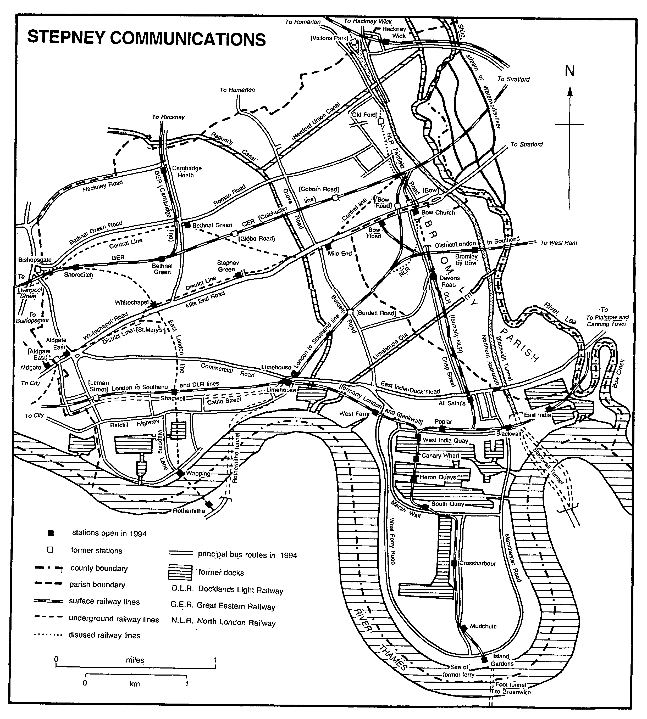
RAILWAYS.
Railways through the western half of the parish, which had been largely built over, ran on viaducts. The railways had little effect on growth there, apart from increasing the number of warehouses and depots, but probably stimulated residential building farther east.
The London & Blackwall Cable Railway opened its line between Stepney and the City, from Blackwall to a temporary station in the Minories in 1840 and to a new terminus at Fenchurch Street in 1841. (fn. 70) The service was intended to tempt travellers away from the river, as it nearly halved the distance by water from London to Blackwall, where they caught the steamboats for Gravesend, but most users of the railway lived or worked around Blackwall or intermediate stations, Cannon Street Road, Shadwell, Stepney, Limehouse, West India Docks, and Poplar. The trains were hauled by cables with a service every 15 minutes, but the operating system was such that a passenger boarding a train at an intermediate station could leave it only at a terminus. After eight years the service was improved by the introduction of steam locomotives.
A branch line was opened in 1849 from the Blackwall line near Stepney station to a station at Bow operated jointly with the Eastern Counties Railway (Great Eastern Railway from 1862), and from 1866 the railway was leased and operated by the G.E.R. Intermediate stations were opened at Burdett Road in 1871 and Leman Street in 1877. The Bow branch's freight trains to the docks from the east needed to reverse on the Blackwall line until the construction of a spur between Salmon's Lane and Limehouse junctions. The North Greenwich branch line from Millwall junction to the south end of the Isle of Dogs was added in 1871. Six goods depots were built along the line near the City by four railway companies and the Port of London Authority.
In 1850 the East & West India Docks & Birmingham Junction Railway (later the North London Railway) linked its line with the Eastern Counties and the London & Blackwall via Bow, using Fenchurch Street as its City terminus until it opened Broad Street in 1865. The final section of the N.L.R. between Bow and Poplar was opened in 1852, but a passenger service began only in 1866 when the N.L.R. opened Poplar station in East India Dock Road. (fn. 71)
The Eastern Counties ran trains to Romford from a temporary terminus at Mile End in Cambridge Road (Devonshire Street) in 1839. (fn. 72) Its permanent terminus was opened in 1840 at Shoreditch, renamed Bishopsgate in 1847, and the line was extended to Colchester in 1843. Stations were opened at Mile End (near the temporary terminus) in 1843 and Coborn Road (Bow) in 1865.
The G.E.R. opened a line through Hackney to Enfield and Chingford in 1872, later extended to Cambridge, which branched off the Romford line at Bethnal Green junction; Mile End station was replaced in 1872 by Bethnal Green station which served both lines; a station was opened at Cambridge Heath on the Enfield line, and at Globe Road on the Romford line in 1884. Bishopsgate (low level) station on the new line was built for passengers and the old terminus reserved for goods. A new pasenger terminus was opened at Liverpool Street in 1874.
The East London Railway Co. was formed in 1865 to purchase the Thames tunnel, (fn. 73) and a railway was opened through it in 1869 between Wapping & Shadwell station by the Thames at Wapping Lane and the Brighton and the South Eastern lines at New Cross (Surr.). (fn. 74) Despite difficulties in tunnelling through the gravel under the London docks, an extension northward to Liverpool Street station linking the East London railway with the G.E.R.'s main line was opened in 1876, with new stations at Shoreditch (in Pedley Street on the Bethnal Green/Mile End New Town boundary), Whitechapel (opposite the London Hospital), Shadwell (where it crossed the Blackwall railway), and the renamed Wapping station. From 1884 the line was linked with the Metropolitan & District line, with regular services from Whitechapel to New Cross. The East London was acquired by the Southern in 1925, but working arrangements remained the same.
In the 20th century competition from improved roads and Underground lines led to a contraction of inner suburban passenger services. The G.E.R. found it more profitable to use its lines in Stepney for freight and traffic from the outer suburbs and closed three inner suburban stations in 1916: Bishopsgate (low level), Globe Road, and Coborn Road. Coborn Road was reopened in 1919 but closed finally in 1946, as were the platforms on the Romford line at Bethnal Green. Passenger services into Fenchurch Street on the Blackwall line east of Limehouse and on the North Greenwich branch ended in 1926. Burdett Road, Shadwell, and Leman Street closed in 1941. The G.E.R.'s lines were electrified between 1949 and 1960, and the area continued to be served by Bethnal Green and Cambridge Heath stations on the Liverpool Street to Cambridge line, and Limehouse on the Fenchurch Street to Southend line. (fn. 75) The East London Railway was acquired by the new London Transport Executive in 1948. In 1994 Shoreditch station was open only for peak hours, but the other stations continued to connect the area with Rotherhithe, Surrey Docks (renamed Surrey Quays and serving a large shopping centre from the 1980s), and New Cross.
In 1878 the scheme by the Metropolitan and the Metropolitan District Railway companies to complete the Circle line included connections from north and south of Aldgate station to run eastward and join the East London line south of Whitechapel station. The joint company opened stations in 1884 at Aldgate East on Whitechapel High Street just inside Whitechapel parish, and St. Mary's or Whitechapel (St. Mary's) in Whitechapel Road opposite St. Mary Street. The District also built its own terminus in 1884 beside the East London's Whitechapel station, called Whitechapel (Mile End).
The District Railway and the London, Tilbury & Southend (L.T.S.) Railway built an Underground line from the District's station at Whitechapel to the L.T.S.'s line at Campbell Road junction (Bow), opened in 1902 with stations at Stepney Green (in Mile End Road at Globe Road), Mile End (in Mile End Road near Burdett Road), and Bow Road. The new line was intended to relieve the L.T.S.'s service into Fenchurch Street and carried heavy traffic, mostly from Essex rather than Bow and Stepney. (fn. 76) Whitechapel (Mile End) was renamed Whitechapel in 1901 and reconstructed in 1902. In 1938 Aldgate East was rebuilt east of its original site and St. Mary's was closed. (fn. 77)
The Underground Railway's Central line from Liverpool Street to Stratford (Essex) was opened by the London Passenger Transport Board in 1946, with stations at Bethnal Green and Mile End (connected with the existing District line station). (fn. 78)
The Docklands Light Railway was constructed in the 1980s by the London Docklands Development Corporation to serve new offices on the Isle of Dogs, largely using the embanking, viaducts, and stations of the former Blackwall railway. Its City terminus was initially at Fenchurch Street, later at Tower Gateway close to Tower Hill, but an extension to Bank Underground station was opened in 1991. The line from the City to the Isle of Dogs had stations at Shadwell connecting with the East London line, Limehouse (formerly Stepney East) connecting with the Fenchurch Street to Southend line, and Westferry, and an extension northward to Stratford (Essex), using the former N.L.R. line, had stations at Poplar, All Saints, Devons Road, and Bow Church connecting with the District line. Five other intermediate stations on the line in the Isle of Dogs ending at Island Gardens were common to both lines. (fn. 79) An extension east to the Royal Victoria Docks (London City airport) and Beckton (Essex), with stations at Poplar, Blackwall, and East India, was built in 1994, despite doubts about the future of the line following a decline in use. Rail links for the Isle of Dogs were to be increased with an extension of the Jubilee line through south London approved in 1994.