A History of the County of Northampton: Volume 5, the Hundred of Cleley. Originally published by Victoria County History, London, 2002.
This free content was digitised by double rekeying. All rights reserved.
'Hartwell', in A History of the County of Northampton: Volume 5, the Hundred of Cleley, (London, 2002) pp. 176-197. British History Online https://www.british-history.ac.uk/vch/northants/vol5/pp176-197 [accessed 23 April 2024]
In this section
HARTWELL
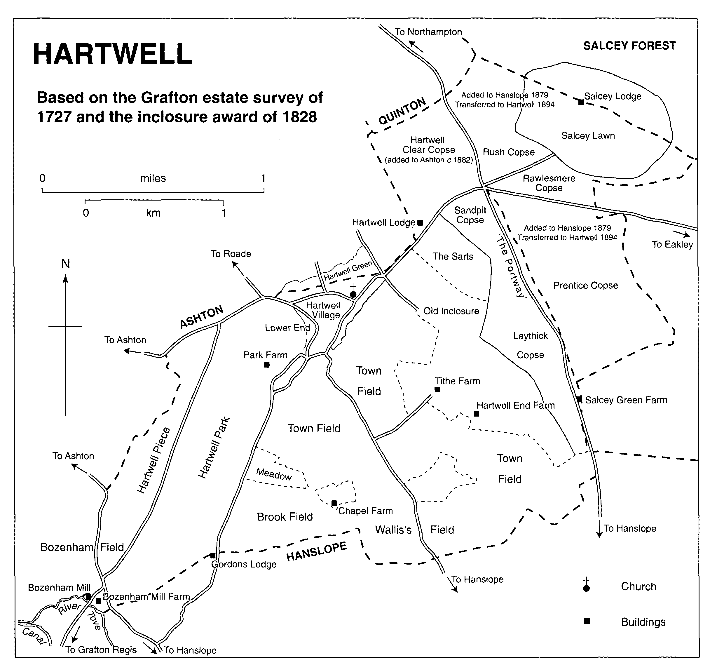
Before modern boundary changes the township of Hartwell, part of the ancient parish of Roade, (fn. 1) occupied 1,570 acres (fn. 2) towards the north-eastern corner of Cleley hundred. (fn. 3) The township was roughly triangular in shape, bounded on the south by the Buckinghamshire parish of Hanslope (and to a small extent by Grafton Regis), on the north-west by Ashton (another township of Roade), and on the northeast by Salcey Forest. The land rises from about 240 ft. above sea level in the south to 400 ft. near Salcey Forest. Boulder Clay covers most of the parish, apart from small outcrops of Oolitic Limestone south and east of the modern village. (fn. 4)
The northern part of the forest lay mainly in Piddington parish (with a small portion in Quinton) and on its south-eastern side extended into Hanslope. Most of the south-western half of Salcey, apart from a small area in Hartwell, continued to be extra-parochial until 1879, when the greater part of it was added to Hanslope civil parish, although it remained in Northamptonshire. (fn. 5) In 1894 that area, including Salcey Lawn, the mansion in the heart of the forest, was transferred to Hartwell civil parish. (fn. 6) A small portion of the extra-parochial lands on the north-western edge of the forest, including Hartwell Clear Copse and Hartwell Lodge, was added to Ashton civil parish, rather than Hanslope. (fn. 7)
In 1964, (fn. 8) and again in 1970-2, (fn. 9) as the builtup area of Hartwell expanded into Ashton, the parish council attempted, without success, to secure a boundary extension that would have placed the whole of the village in Hartwell. A change on these lines was finally achieved in 1994. (fn. 10) In 1991 there was a minor boundary change in the south of the south of the parish, near Gordons Lodge. (fn. 11)
Until the inclosure of Ashton and Roade in 1819, (fn. 12) which also dealt with some scattered parcels in Hartwell, the common fields of the three townships were intermixed, and until the inclosure of Hartwell in 1828, some land in that township (known as Ashton tithing) paid tithes to Ashton, (fn. 13) although it was never part of Ashton parish. (fn. 14)
Hartwell was assessed as part of the township of 'Roade with members' to medieval taxes, although the three villages were distinguished. (fn. 15) By the early 16th century Hartwell was assessed separately (fn. 16) and presumably relieved its own poor and maintained its highways from the same period, although no records survive to confirm this. (fn. 17) Its population was returned separately from 1801 and in the 19th century the township had all the characteristics of a civil parish, including a parish council from 1894. (fn. 18)
In 1301 49 householders were assessed to the lay subsidy in Hartwell compared with 21 in Roade and 36 in Ashton; (fn. 19) by 1524 the number had fallen to about 30. (fn. 20) In 1674 80 households were assessed to the hearth tax, of which 30 were discharged through poverty. (fn. 21) Similarly, in 1720 there were said to be about 80 families living in Hartwell, (fn. 22) and in 1801 there were 357 people in 73 houses. The population then rose to a peak of 542, the figure returned in both 1851 and 1861, before falling steadily to 337 in 1931. A marked increase to 588 by 1961 was followed by a more rapid rise to over 1,100 ten years later. In the 1990s the population of the village (including the portion that was in Ashton parish until 1994) was probably about 1,850. (fn. 23)
HATWELL
Based on the Gratton estate survey of 1727 and the inclosure award of 1828
Roads to Hanslope, Ashton, Roade and Grafton Regis run through the parish, although none appears ever to have been of more than local importance. The main road through Salcey Forest, leading from Hanslope towards Northampton, was known as the Portway in the 19th century, and in places more or less followed either the county boundary or that between Hartwell and the extra-parochial portion of the forest, (fn. 24) suggesting that it was of some significance from an early date. The London & Birmingham Railway of 1838 cuts through the parish towards its south-western corner, as does the M1 motorway, opened in 1959, to the north-east. The nearest railway station (closed in 1964) was two miles away at Roade; (fn. 25) the nearest motorway junction is at Collingtree, four miles away.
Landscape and settlement.
In the south-west corner of Salcey Forest, in Prentice Coppice, there is a roughly oval, probably Iron Age, enclosure, known locally as Egg Rings, bounded by a continuous bank and external ditch with a single plain inturned entrance in the centre of the eastern side. At Bozenham, in the south-west of the parish, Roman coarse wares and part of a quern thought to be of the same period have been found. (fn. 26)
The main settlement in Hartwell in the Middle Ages was evidently a hamlet or small village near the southern boundary of the township, to the west of the road from Hanslope to Roade and south of a brook which flows westsouth-west to join the Tove about a mile away. Here stood the medieval chapel dedicated to St. John the Baptist which survived until the mid 19th century. (fn. 27) By the mid 16th century this village had been entirely deserted and its site absorbed into a single farmstead named Chapel Farm. (fn. 28) It appears to be impossible to date the desertion more closely. Most of the earthworks indicating the sites of houses were destroyed by ploughing in 1976; fragmentary foundations of the chapel and traces of fishponds survived in the 1980s. (fn. 29)
In addition to this settlement, archaeological evidence for lost medieval farmsteads or hamlets has been found at several other places in the parish. (fn. 30) One of them may be the farm named Wike, mentioned in the late 13th century and early 14th; (fn. 31) this may have been near Salcey forest, since St. James's abbey, Northampton, received a gift of 4 a. of assarts near Wike sometime in the 12th or 13th century. (fn. 32) There was also a windmill at Wike in the 13th century, (fn. 33) although whether its site is indicated by the field-name 'Windmill Piece', which lay on the higher ground to the north of the medieval village (fn. 34) is not clear. In the south-western corner of the township, on the banks of the Tove, a farmstead named Bozenham is mentioned in the mid 12th century. (fn. 35) There was a water-mill in Hartwell in 1086. (fn. 36)
The township contained three open fields and areas of comon meadow in the Middle Ages, the remnants of which were inclosed under an Act of 1825 and an award of 1828. (fn. 37) Other land appears to have been won piecemeal from Salcey Forest and was never cultivated in common. (fn. 38)
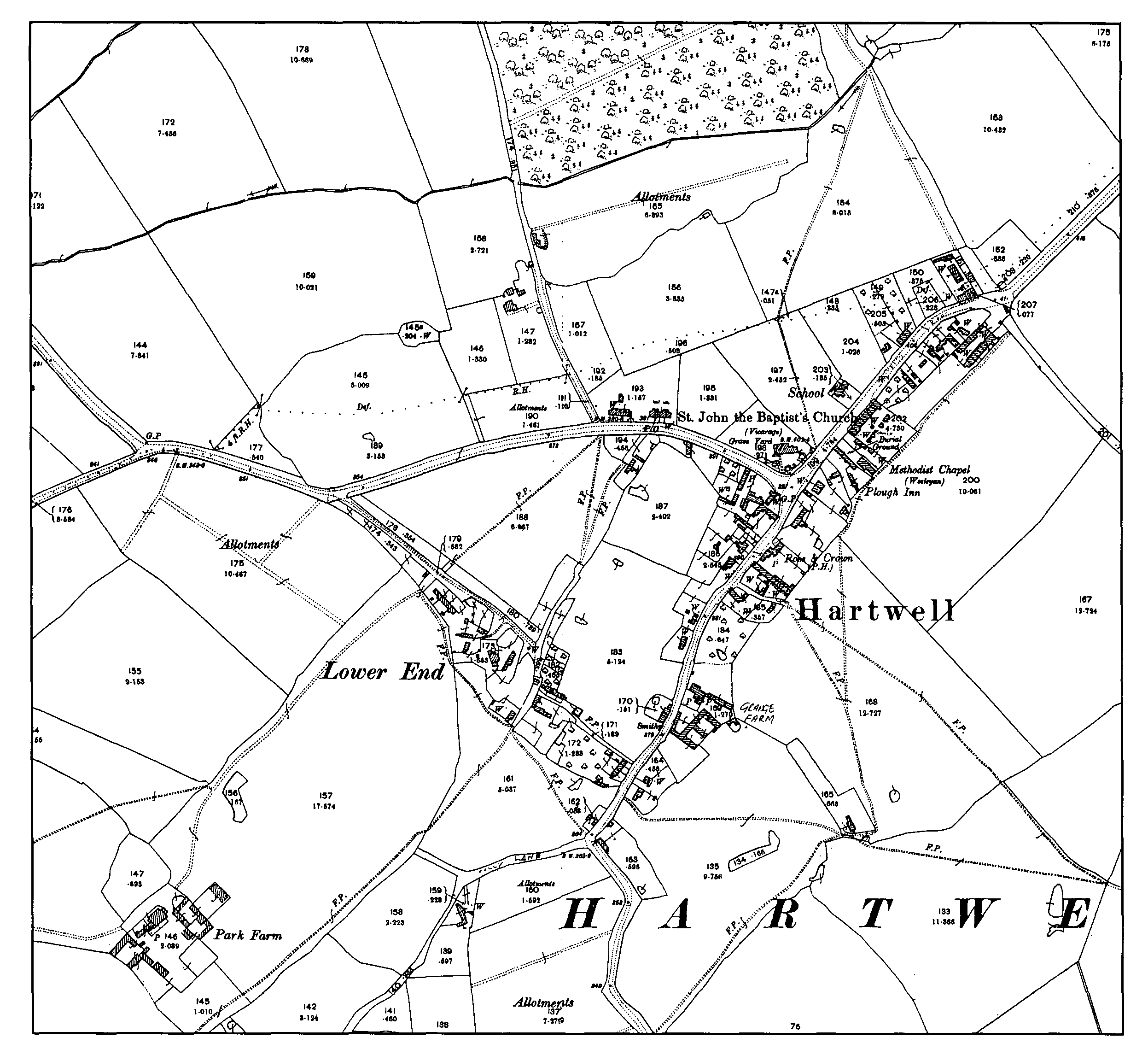
On either side of the road running from the Portway through Hartwell lay a roughly triangular area of common waste known as Hartwell Green (part of which was in fact in Ashton), which extended from the edge of the forest to the point at which the road divided, with lanes running south-east to Hanslope, south-west to Bozenham and west to Ashton and Roade. There had probably been some incroachment on this waste by squatters in the Middle Ages but by the early 18th century, following the desertion of the village at Chapel Farm, it had grown into the principal settlement in the township. Both sides of the main road, from the edge of the assarts adjoining the forest in the north-east to the fork in the road near the edge of the park in the south-west, were lined with farmhouses and cottages, with some further, less regular building, known as Lower End, extending north-westward alongside the lane to Roade and Ashton near the park boundary. The crofts on the south-east side of the main road backed on to the northern end of Town Field, those opposite on to the uninclosed remnant of Hartwell Green, some of them straddling the boundary with Ashton. (fn. 39) In 1727 almost all the houses in the village belonged to the 2nd duke of Grafton, the lord of the manor, a further indication that they had originated as incroachments on the manorial waste. (fn. 40)
The village at Hartwell Green stood between 70 and 100 ft. higher than its medieval predecessor at Chapel Farm. It was better positioned for communications with neighbouring communities, since it grew up at the point at which roads from all directions met, and was closer to the main road through Salcey Forest. It was also convenient for the common-field arable of the township, although it lay on the edge of the cultivated area, rather than in its midst. It was less well placed for water, since the only stream nearby rose on the edge of the forest and skirted Hartwell Green to the north as it flowed down to Ashton, presumably leaving villagers largely (if not wholly) dependent on wells until a piped supply was installed shortly before the First World War. (fn. 41)
The oldest surviving buildings at Hartwell Green all date from the 17th or early 18th century and are built of coursed rubble limestone. Several (e.g. nos. 1, 22, 41 and 52 Park Road) still had thatched roofs at the time of writing, which elsewhere had been replaced with slate. The smaller cottages have two-unit plans; 38 Forest Road is a more ambitious fourbay, three-unit lobby entrance house, with two storeys and attics, built by John Mould in 1681. (fn. 42) All the older houses are shown on the plan of 1727 (fn. 43) and several other plots were occupied at the time of writing by heavily modernised buildings that may in some cases incorporate remains of those marked on the map.
There was little new building in the village between the early 18th century and the late 19th, when its layout was much the same as that shown in 1727. (fn. 44) The remaining common arable and meadow, and the remnants of Hartwell Green, were inclosed in 1828, (fn. 45) leaving most of the land of the township divided into four consolidated properties, centred on Hartwell Park in the west, Chapel Farm in the south, Tithe Farm in the east, (fn. 46) and the Grafton estate in the middle, adjoining the village. (fn. 47)
By 1830 the Grafton estate had established a new farm south of the village, near Hanslope Road, which became known as Stonepit Farm, (fn. 48) and in the mid 19th century rebuilt the main farm in the village, later known as Grange Farm. On the Castleman (Tithe Farm) estate a new farm was established on the west side of the Portway near the southern end of Salcey Forest, which confusingly became known as Hartwell Green Farm, despite being some way from Hartwell Green and much closer to Salcey Green. (fn. 49) On the opposite side of the parish, on the edge of the Hartwell Park estate, the building of the London & Birmingham Railway appears to have led to the demolition of an old farmstead just inside Hanslope parish (and outside the park) and its replacement with Gordons Lodge (apparently named after Mary Gordon, the occupier in 1851), whose buildings were also mostly in Hanslope but lay inside the park boundary. (fn. 50) The Whalley Charity estate at Chapel Farm remained a single holding.
Hartwell Village
The inclosure commissioners did not greatly alter the highways in the township, apart from laying out a new alignment for Ashton Road from the western edge of the built-up area at Lower End, across Hartwell Green to a junction with the main street roughly in the middle of the village. (fn. 51) At the junction a new church was erected in 1851 to replace the medieval chapel, (fn. 52) almost opposite Hartwell's only other place of worship, a Wesleyan Methodist chapel of 1814. (fn. 53) A small National school was built on the same side of the road as the church in 1861. (fn. 54) In 1894 Hartwell Lodge, which stood on the main road at the entrance to Salcey Forest, within the portion of the former extra-parochial lands added to Ashton parish, was acquired as a parsonage. (fn. 55)
In the village, where virtually all the houses belonged to the Grafton estate, there was a gradual increase in the number of cottages from about 30 at the end of the 18th century (fn. 56) to twice that number by 1875. (fn. 57) Part of this increase resulted from the building of eight cottages (described as new in 1875), in a restrained cottage ornée style similar to that employed at Stoke Bruerne, on Ashton Road on the western edge of the village, although there was no large-scale renewal of the housing stock by the estate in the parish. Elsewhere in the village, barns were converted to dwellings or cottages subdivided. (fn. 58)
The Grafton estate in Hartwell, including nearly all the houses in the village, was first offered for sale in 1913; properties left unsold reappeared in the 1919 auction. (fn. 59) Neither those sales, nor that of the former Castleman estate centred on Tithe Farm (renamed The Elms by its purchaser) in 1896, which changed hands again just before the First World War, (fn. 60) led to much new building. A village hall was erected in 1924 on land previously owned by the Grafton estate and sold in 1913 to the Northampton Brewery Co. Trustees bought the site for £25 and the building cost £809, mostly raised locally, although £250 was borrowed on mortgage. (fn. 61) Otherwise, there was little change until the first council houses were built in the 1930s. (fn. 62) In 1920, after a considerable difference of opinion in the village, two war memorials were erected, one of stone in the churchyard and another of wood from Salcey Forest in the main street. Both had names of men who died in the Second World War added after 1945 and in 1964-5 the timber memorial was renewed. (fn. 63) Italian prisoners of war were billeted at Park Farm during the Second World War and German prisoners also worked locally. (fn. 64)
The rural district council resumed building after 1945, erecting 74 houses and flats in Salcey Avenue (1949-53) and Salcey Close (1955-6) at the northern end of the village. (fn. 65) From the early 1960s land began to be released for private housing, mainly on the south-eastern side of the main street and at Lower End. By 1970 planners had drawn a boundary round the existing built-up area, beyond which new development would not normally be allowed and was invariably opposed by the parish council. (fn. 66) The granting of outline consent for building on 13 a. outside this area in 1973 caused great bitterness both within the council and in the village as a whole. When the scheme went ahead, residents complained that the rural character of Hartwell was being damaged, with 153 houses built without the additional shopping or other services that were also needed. (fn. 67) The village did, however, acquire a new primary school in 1962, replacing the building of 1861. (fn. 68)
Between the early 1970s and the late 1990s there was little further expansion of the built-up area, although infill development continued (as envisaged by the local planning authority), (fn. 69) and Hartwell saw the same general improvement in its housing stock, including former council houses, that occurred in all the villages in the area, as south Northamptonshire was increasingly favoured by professional families as a residential area within easy commuting distance of both Northampton and Milton Keynes. (fn. 70)
During the 1960s plans for a playing field were revived and went ahead independently of the parish council, who contributed to the cost. (fn. 71) The field was opened in 1966. In 1989- 90 the parish hall, to which a kitchen was added in 1948, was sold for £48,000 and the hall and playing field charities amalgamated to run a new community centre built at the playing field, which was opened in 1991. (fn. 72)
MANORS AND OTHER ESTATES
The manor of Hartwell.
In 1086 William Peveril held of Odo bishop of Bayeux 4½ hides and the fifth part of half a hide in Hartwell, which in 1066 Edmar had held freely. (fn. 73) After the battle of Hastings the Conqueror placed Odo in charge of Dover Castle and most, if not all, his lands were subject to castle guard there, including Hartwell, which had to provide two knights to serve 15 days each every year. The duty was subequently commuted to a payment of £1 a year for the two, i.e. 8d. a day for each knight. (fn. 74)
After Odo's disgrace and exile early in William II's reign, Hartwell was among his estates which passed to Walchelin Maminot, who in 1138 held Dover Castle for the empress Maud (fn. 75) and appears in the 12th-century Northamptonshire Survey as the lord of Hartwell. (fn. 76) The obligation laid on his barony to provide two knights twice a year for castle guard at Dover continued in the 13th century. (fn. 77) Walchelin's daughter, who became a coheiress of his son (also named Walchelin), married Geoffrey de Say. (fn. 78) The overlordship appears to have des cended with the barony of Say. William Lord Say in 1242, his son William in 1284 and 1285, and finally William Heron, Lord Say, in 1404, were recorded as holding the two fees, (fn. 79) although in 1346 and 1428 they were said to have only one fee, part of the honor of Dover. (fn. 80) Anthony Earl Rivers, the undertenant of the manor, was still making payments for castle guard at Dover in 1482. (fn. 81)
At some date in the 12th century the two fees were divided into four half-fees; three of them, to judge by the names of their recorded tenants, appear to have been in Ashton and Roade. The fourth, held by Nicholas before 1189 (fn. 82) and by John of Hartwell in 1242, (fn. 83) was probably in Hartwell. Nicholas may have been a member of the family of Hartwell which included Geoffrey and his son William and Simon in the early 12th century and that or another Simon between 1148 and 1167, who gave the advowson of Hartwell chapel and other lands to St. James's abbey, Northampton. (fn. 84) A John of Hartwell in 1346, (fn. 85) and another John Hartwell in 1428, held part of a fee in Hartwell in Dover honor; (fn. 86) the rest was probably in Roade. (fn. 87)
By 1482 the manor of Hartwell had passed into the hands of Anthony Woodville, Earl Rivers, (fn. 88) from whom it passed to his brother and heir Richard, Earl Rivers, who in 1489 included it in a settlement of his estates. (fn. 89) From the Woodvilles, Hartwell descended with Grafton to Thomas Grey, marquess of Dorset, at whose death in 1501 both manors passed to his son and heir, also named Thomas. In 1527 Dorset gave them to King Henry VIII in exchange for estates in Leicestershire, and in 1542 the two formed the nucleus of the honor of Grafton on its establishment. (fn. 90) The manor of Hartwell thenceforth descended with the rest of the honor until 1987, when it was offered for sale by auction. (fn. 91)
Hartwell End.
In addition to the estate acquired from the marquess of Dorset, the Crown in 1537 purchased what was described as the manor of Hartwell End from William Marriott of Ashton, yeoman, including premises in Hartwell, Ashton, Roade, Hanslope and Castlethorpe, (fn. 92) which was subsequently annexed to the honor of Grafton. (fn. 93) The estate was centred on a house on the site of the later Hartwell End Farm, which was leased to a succession of gentry tenants in the later 16th century. (fn. 94) In 1617 the mansion (with other premises, including Chapel Farm in Hartwell), (fn. 95) was leased by James I to Sir Francis Bacon, Sir John Walter, Sir James Fullerton and Sir Thomas Trevor for 99 years. In 1627 the lessees assigned the residue of the term to Sybil Ouseley (fn. 96) and the following year the Crown alienated the estate permanently by granting Richard Ouseley the reversion in fee at the expiry of the term of 99 years, to be held as of the honor of Grafton. (fn. 97) At the time the estate was known as Perkins Farm, (fn. 98) having been leased to Richard Perkins (or Parkins) in 1557. (fn. 99) The fee farm rent was sold off in 1651. (fn. 100)
Hartwell End later belonged to the Knight family of Northampton. In 1716 John Knight conveyed to the trustees of his marriage settlement a mansion house and about 150 a. of land in Hartwell. (fn. 101) In 1742 Knight's widow Frances conveyed this estate to her son John, then of Bringhurst (Leics.), (fn. 102) who re-settled it on his own marriage in 1763. (fn. 103) His widow Mary in turn conveyed it to the trustees of her daughter Frances's marriage settlement in 1792, when she became the wife of the Revd. John Langham Dayrell. In 1799 the estate consisted of a house and 139 a. (fn. 104) In 1819 Dayrell was able to buy for £211 the fee farm rent of £10 8s. 8d. charged on the estate when it was alienated by the Crown in 1628, which had been acquired (with others, in Hartwell and elsewhere) by George, marquess of Halifax, in 1689. (fn. 105) Finally, in 1826, William Castleman purchased the Hartwell End property for £3,150 from Dayrell and his wife Frances, who was the heiress of both her father, the Revd. John Knight of Towcester, and her grandfather, John Knight of Northampton. (fn. 106) It then descended with the rest of the Castleman estate in the parish. (fn. 107)
Hartwell End House dates from the early 17th century, with 18th-century extensions, and was considerably enlarged c. 1900 and c. 1930. Apart from a single-storey modern extension, it is of two storeys with attics, built of stone and brick, all except for stone details pebble-dash rendered. It has a collar-truss roof covered in plain-tile. The older windows have ovolomoulded mullions. (fn. 108)
Hartwell Park.
In 1630 Hartwell Park, greatly enlarged by Henry VIII, was granted to Endymion Porter in fee farm. (fn. 109) He evidently reconveyed it to the Crown before May 1633, (fn. 110) when the estate was granted to agents for Sir Robert Berkeley, a justice of King's Bench, who resold it to Sir Francis Crane, the holder of a mortgage over the honor of Grafton. (fn. 111) Crane was succeeded by his widow Mary in 1637. (fn. 112) By 1645 it seems to have passed to Joan, widow of Sir Francis's brother Richard Crane. In that year Sir Richard's sister Joan Bond and her son-in-law William Crane, in an exchange, settled the reversion on Francis Arundel. (fn. 113) The estate, described as a manor in the 18th century, (fn. 114) then descended with Stoke Park (in Stoke Bruerne) until 1912, when it was sold to the tenant farmer, Alfred Weston, (fn. 115) whose family still owned the farm at the time of writing. Weston also bought Gordons Lodge in 1912, which was sold to the Ransom family in 1952. (fn. 116)
The lands of St. John's hospital, Northampton.
At some date before 1298 William de Toulouse granted to St. John's hospital lands and tenements in Hartwell and Courteenhall in exchange for a corrody. (fn. 117) In 1299 William of Brampton, parson of Piddington, gave land in Hartwell Wike and elsewhere. (fn. 118) In 1332 the master of St. John's accused the hospital's tenant at Hartwell, William de la Chaumbre, clerk, of wasting, selling and destroying houses and gardens which the master had leased him for life. (fn. 119)
In 1515 the master of the hospital leased all its possessions in Hartwell to Richard Wake of Hartwell at £4 a year. (fn. 120) In 1526 the hospital gave the estate to Wake in fee, reserving a £4 fee farm rent, which passed to the Crown at the Dissolution. (fn. 121) In 1546 Richard Wake settled 'the mansion house of Hartwell called St. John's house' and all his lands there on his second wife Margaret in lieu of jointure, with remainder to his younger son Richard. (fn. 122)
Richard Wake, the remainderman in the settlement of 1546, died in 1581 seised of the St. John's lands in Hartwell and the impropriate tithes of Hartwell. (fn. 123) His son and heir Robert died in 1621, leaving his brother, another Richard, as his heir. (fn. 124) He had no issue and in 1628, the year of his death, entailed his Hartwell estate on Sir John Wake (1602-58), the second baronet and head of the senior branch of the family. (fn. 125) In 1636 and again in 1656 Sir John mortgaged the St. John's estate in Hartwell, then said to consist of a capital messuage, several closes of pasture and 81 a. in the common fields, together with other premises in Hartwell (a cottage and seven closes totalling 71 a.) which had also belonged to Robert and Richard Wake but seem not to have been included in the St. John's lease of 1515. (fn. 126) In 1687 Sir William Wake sold the whole estate, by then heavily mortgaged, to Thomas Jennings of Forest Gate (Bucks.). (fn. 127) In 1717 Jennings and his wife Christian sold to George Montague, earl of Halifax (d. 1739). (fn. 128) Although under an Act of 1740 his Hartwell estate was to be settled in trust for sale, it descended to his son George, who died without male issue in 1771. (fn. 129) His daughter and heiress Elizabeth married John Montagu, styled Lord Hinchingbrooke. (fn. 130) In 1789 he sold the Hartwell estate to Philip Skene, (fn. 131) who lived for a time at Hartwell (fn. 132) and was buried in Hartwell chapel. (fn. 133) He died in 1810, having contracted to sell the estate to William Castleman of Wimborne (Dors.). Castleman and Skene's legatee Maria Ann Margaret Skene completed the sale in 1812. (fn. 134)
In 1826, besides Hartwell End Farm, (fn. 135) Castleman bought Box Close from William Tite of Coleshill (Warws.). (fn. 136) This had formed part of an estate held by John Lansdown of Woodborough (Som.), who died in 1726, leaving it to Richard Lansdown. The latter sold it in 1752 to John Clarke of Hardingstone. (fn. 137) By his will of 1762 Clarke left his estate with remainder to his nephew William Rudd, (fn. 138) who in the event inherited it. In 1783 it passed to his eldest son, William Rudd of Great Houghton. (fn. 139) He in turn sold three years later to John Tite of Hartwell Park, (fn. 140) who in 1809 bequeathed Box Close and some other lands, only part of the property acquired from Rudd, to William Tite, the natural son of his brother George and the vendor in 1826. (fn. 141)
In 1828 William Castleman took the opportunity provided by inclosure to consolidate his Hartwell estate in the north-east of the township, centred on what later became known as Hartwell Tithe Farm, the former St. John's capital messuage, and Hartwell End Farm, the former Knight property. (fn. 142) He had already made some exchanges under the Ashton and Roade inclosure Act of 1816 to the same end. (fn. 143)
Castleman died in 1844, leaving his estate at Hartwell, Ashton and Roade to his son Henry, who himself died in 1863 leaving everything to his wife Emma. (fn. 144) Mrs. Castleman, who made a small exchange with the trustees of Whalley's Charity in 1868 to consolidate the estate further, (fn. 145) died in 1870, leaving her property in trust. The trustees sold in 1896 to a local farmer, Smith Wickins, who thus acquired a tithe-free estate of 419 a. inside a ring fence, including Hartwell Tithe Farm (196 a.), Hartwell End Farm (148 a.) and the more recently established Hartwell Green Farm (64 a.), and 9 a. let as allotments. The estate remained subject to the payment of £16 a year to the curate of Hartwell and £3 to St. John's (which in 1879 had moved to new premises at Weston Favell), (fn. 146) and also a quit rent of £1 13s. 7d. payable to the duke of Grafton. (fn. 147)
In 1906 Wickins sold the farms at Hartwell End and Hartwell Green (and part of Box Close) to Christopher Finnegan, a Northampton contractor, free of the rent charges. (fn. 148) He retained Tithe Farm, which he renamed The Elms, and the allotments until his death in 1908, (fn. 149) when they all passed to his son Joseph Wickins, a farmer and coal merchant of Hartwell. (fn. 150) Following mortgages, the property was sold in 1914 to Christopher Finnegan, (fn. 151) who thus reunited the two parts of the Castleman estate, which remained charged with the payment of £16 to the incumbent of Hartwell until at least the 1960s. (fn. 152) The Finnegan family were still living at The Elms at the time of writing.
The former farmhouse is L-shaped in plan, with one two-storey and one three-storey range, built of coursed rubble limestone beneath a plain-tile roof. There is a large ridge stack near the junction of the two ranges.
Chapel Farm.
After the desertion of the medieval village of Hartwell, its site was consolidated into a single holding, known from the survival of the chapel there as Chapel Farm, which was part of the lands and possessions purchased by Henry VIII from Thomas marquess of Dorset and annexed to the honor of Grafton. (fn. 153) The farm (of 71 a. of arable and 4 a. of meadow) was leased for the first time by the Crown in 1547 to the existing tenant at will, Robert Alcock, for a term of 21 years. (fn. 154) He later assigned the lease to Thomas Merricke, who in 1563 was granted a new lease on identical terms. (fn. 155) The farm was leased to new tenants in 1571 (fn. 156) and 1581. (fn. 157)
In 1617 Chapel Farm was leased for 99 years at an improved rent of £6 13s. 4d. to Sir Francis Bacon and others, who in 1627 assigned the lease to Joseph Downing. Next year the Crown sold the reversion in fee at the end of the 99-year term to Gregory Pratt, Thomas Brereton, George Duncombe and John Bunberry. The fee farm rent reserved in 1628 was sold off to William Tibbs in 1651 (fn. 158) and descended with that on Hartwell End from 1689 or earlier until the early 19th century. (fn. 159)
By 1671 Chapel Farm itself had pased to John Whalley of Cosgrove, who left his uncle Thomas Whalley £20 a year out of the rent for his life, after the death of John's mother-inlaw Anne Whalley. After the death of both Thomas and Anne, the lands were to be charged with an annual payment of £4 to the minister of Hartwell. (fn. 160) The rest of the income from the estate, after Anne's death, was settled in trust for apprenticing boys of Stony Stratford and Cosgrove. (fn. 161) It is not clear when the charity took effect: in 1742 the fee farm rent was said to have been lately payable by Thomas Whalley and then by Anne Cornelius, who was perhaps Anne Whalley after remarriage. (fn. 162) Mrs. Cornelius, then a widow again, was the tenant of the farm in the late 17th century, (fn. 163) although she was living in London. (fn. 164)
After inclosure in 1828, the estate consisted of 177 a. within a ring fence around Chapel Farm, and Blacksmith's Close, a parcel of 2 a. near Hartwell village. (fn. 165) A little land was exchanged with Mrs. Castleman in 1868. (fn. 166) From 1878, as well as paying £4 a year to the incumbent, the trustees also subscribed to the Church school at Hartwell and in 1895 made a donation towards the building of the parsonage. This led to complaints from Nonconformists in Cosgrove and Stony Stratford and criticism from the Charity Commissioners. (fn. 167)
In 1920 the trustees put the Hartwell estate up for auction but only succeeded in selling Blacksmith's Close. (fn. 168) Disquiet was expressed at Cosgrove parish meeting in 1949 at the low rent received for Chapel Farm. (fn. 169) The complaints were renewed at the 1952 meeting, by which time the trustees were proposing to sell to the tenant. Joan Wake, then a prominent member of Cosgrove parish council, complained that the tenant was being allowed to buy at £8,600, although a higher offer had been received and the sale had not been advertised. The price was later raised to £9,500 and it was noted that the tenant had put a lot of money into the farm after taking it on in a deplorable condition in 1939. Miss Wake pointed out that the trustees had spent £2,041 on repairs over the previous 14 years and made no charitable grants for the last seven. (fn. 170) By 1963 Chapel Farm had been acquired by Hesketh Estates; it remained charged with the payment of £4 a year to the incumbent of Hartwell. (fn. 171) In 1993 the farm had 270 a. of land and was owned by William Smith. (fn. 172)
Chapel Farmhouse is a two-storey, four-bay building of coursed rubble limestone, beneath a plain-tile roof, with brick ridge and end stacks. It is presumably 18th-century in origin, although much altered since.
Nether Farm and the Folly.
Nether Farm was conveyed in 1440 by John Church to his son Richard and remained in the family until 1659, when John Church of Whittlebury left the house and 18 a. to a friend named John Evans the younger of Quinton. (fn. 173) In 1667 John Evans, then of Alderton, settled the property on the trustees of his marriage settlement, (fn. 174) and in 1709 his widow Ann (then the wife of William Manning of Hardingstone) and their son Butler Evans of Flore sold Nether Farm and a newly built malting kiln, malt house, and dovehouse to John Mould of Hartwell. Mould, as the Evanses' tenant, had erected the latter buildings on land adjoining his own house, (fn. 175) which stood on the edge of Hartwell Park, (fn. 176) some distance from Nether Farm.
John Mould left two female cousins as coheiresses, one of whom married Edward Church and the other John Higgs; the Hartwell property passed to Higgs and his wife Joan, and after their death to their son John Higgs, who in 1733 sold to John Grey. (fn. 177) From Grey's widow and son the estate passed to Thomas Newman, whose widow in turn sold to Richard Hindes of Hartwell in 1759. (fn. 178) Hindes left the two messuages to his sons John, William and Richard as tenants in common in 1777. (fn. 179) The estate was later acquired by John Cole Richardson, who in 1828 exchanged the site of Nether Farm for land adjoining his home at The Folly, (fn. 180) as the property near Hartwell Park was known by then. By the 1880s the buildings at Nether Farm had disappeared. (fn. 181) Richardson later moved to Roade, where he died in 1850, leaving the Folly to his second wife Comfort (whom he had married three years before) (fn. 182) and her heirs. (fn. 183) Mrs. Richardson died in 1865, leaving most of her estate to be divided between five beneficiaries. (fn. 184)
The lands of other religious houses.
St. James's abbey, Northampton, as well as owning the tithes of Hartwell in the Middle Ages, (fn. 185) received at least five gifts of houses, land and rent in Hartwell and Wike, presumably in the 12th or 13th century. (fn. 186) In 1342 William Braha assigned the tithes of his assart near the Portway in Salcey Forest to St. James, (fn. 187) and two years later Robert de Kendale made a similar assignment from his assart in the forest. (fn. 188) Leases of parts of the abbey's estate in Hartwell survive from the early 16th century, (fn. 189) including a lease in reversion of the tithes to Richard Wake in 1531. (fn. 190) The lands and tithes of St. James in Hartwell were acquired in 1576 by John and William Mershe, from whom they were purchased by Francis and Edward Barker. They in turn sold to Richard Wake, who died seised of them in 1581. (fn. 191) Thereafter they were merged with the rest of the Wake estate in the parish. (fn. 192)
Delapre Abbey, also in Northampton, had a cottage and 12 a. of land in Hartwell, which in 1544 were granted in fee to John Maynard and William Breton (fn. 193) and in 1581 were part of the Wake estate in Hartwell. (fn. 194) A fee farm rent of 5d. a year reserved in the grant of 1544 appears to have been sold c. 1650. (fn. 195) The abbey also had a tenement called Nonleys in Hartwell, which in 1529 was leased to William Marriott for 40 years at 9s. a year. (fn. 196) Nonleys was annexed to the honor of Grafton after the Dissolution and in 1567 was leased to Richard Wake for 21 years at the same rent. (fn. 197) In 1580 Richard surrendered this lease in favour of one for three lives, still at a rent of 9s. (fn. 198) The premises appear later to have been granted in fee farm, since a reserved rent of 9s. on lands in Hartwell once of Delapre Abbey was also scheduled for sale in about 1650. (fn. 199)
HARTWELL PARK.
The medieval park to the south of Hartwell Green was greatly extended by Henry VIII, following his acquisition of the manor. In 1558 it was said that 25 a. had been a park since the 1450s but that 232 a. had been added out of the fields of Ashton, Hanslope and Hartwell in 1540 and later, although elsewhere in the same survey the park was reckoned to contain 266 a. (18 a. of meadow, 215 a. of pasture and 33 a. of woodland), enclosed within a pale of 860 perches and 18 feet. An annual payment of 5s. was due to the rector of Ashton for tithes of land lost to the enlargement of the park, and another of 46s. 8d. to the incumbents of Roade, Hartwell and Hanslope for the same reason. (fn. 200)
The keepership of Hartwell Park, and of the other parks on the estate, was one of a group of offices held with the stewardship of the honor by a succession of great magnates in the 16th century and early 17th, under whom local yeomen were appointed deputy keepers for the individual parks. (fn. 201) The keeper at Hartwell had a lodge, which in 1558 needed repairs costing 10s., and was allowed ten loads of wood a year for fuel, (fn. 202) which might be drawn from the other parks if, as in 1553, there was insufficient browse wood in Hartwell itself. (fn. 203) The park contained oak worth £98 3s. 4d. and coppice worth £22 0s. 10d. in 1558. (fn. 204)
In 1571 the earl of Leicester, as steward of the honor and keeper of the parks, received a report from John Wake that while Grafton and Stoke parks seemed 'indifferent fair' and Pury Park 'not so fair', Hartwell was the 'meanest of all'. (fn. 205) Four years later there were complaints about 'great disturbance' to the king's game in the park. (fn. 206) Repairs to the hedges and fences were carried out in 1586 (fn. 207) and more work was needed in 1595 after storms destroyed 270 poles of paling, three locks and a gate. (fn. 208) A survey in 1615 revealed that 300 perches of paling required repair, of which 100 would need completely replacing with new materials; altogether 14 loads of timber were wanted. All the timber could be found in Whittlewood, Salcey or Hartwell Park itself, and the tops and lops would serve for fuel when the king next made a progress through the honor. (fn. 209) It was possibly for these repairs that John Cooke, the deputy keeper in charge of the park, was allowed £30 in 1623, in addition to the £20 already paid. (fn. 210)
The last of the great magnates to hold the keepership of Hartwell Park, the 4th earl of Dorset, was appointed in 1629. (fn. 211) Later that year the post was granted for his life to Richard Oliver (to whom the office had been assigned by the duke of Buckingham when he had been the titular keeper earlier in the 1620s), (fn. 212) and after his decease to Charles Porter, a godson of the king and second son of Endymion Porter, a groom of the bedchamber, (fn. 213) who in 1630 secured a grant in fee farm of the park. (fn. 214) The estate then contained 319 a. (23 a. of meadow, 212 a. of pasture and 84 a. of wood, implying further extension, and planting, since 1558), (fn. 215) well-stocked with deer, with a capital messuage for the keeper. The grant included the office of keeper, all the deer and other beasts, and great timber as well as coppice, with power to dispark. (fn. 216) Porter appears to have disparked the land, which in 1633 was described as a 'park or late park'. (fn. 217) He evidently reconveyed the estate to the Crown, since it was granted out again in 1633 and became part of the Stoke Park estate, as it remained until the farm was sold to the sitting tenant in 1912. (fn. 218)
The fee farm rent reserved in the grant of 1630 was sold in 1651 to Francis Arundel. (fn. 219) From 1689, if not before, until the early 19th century it descended with the rents charged on Hartwell End. (fn. 220)
The lodge in Hartwell Park was extensively refurbished, if not rebuilt, in 1586. The walls were repaired and the roof appears to have been entirely replaced, using common tiles and ridgetiles bought from Richard Bourton of Biddlesden (Bucks.); other tiles came from Lathbury and 'Wotton', perhaps Wotton Underwood, also in Buckinghamshire. The rubble for the walling was probably obtained locally but freestone was brought from Harlestone for the chimney stack. Sand came from Roade and lime from Cosgrove for the mortar. A glazier from Little Harrowden fixed 33 ft. of glass and Nicholas Smith of Stony Stratford was paid for locks and hinges for the doors and casements for the windows. Robert Trotter spent six days making 'flowers', perhaps decorative plasterwork for the ceilings. (fn. 221)
The outcome of this campaign may have been the basic structure of the present Park Farmhouse, a five-bay building of two storeys and attics, of coursed rubble limestone with a plain tile roof. The massive stone ridge-stack matches the evidence of the accounts, although there is no indication that bricks were obtained in 1586 to build the six diagonally-set flues which are a feature of the building today. The house was altered in the 19th and 20th centuries. (fn. 222)
The outbuildings at the lodge were still timber-framed in the early 17th century: in 1615 four bays (about 50 ft.) were said to be so decayed as to be about to fall; the timber was so rotten that it would be as cheap to rebuild in stone, of which about 10 perches would be needed. (fn. 223) It is possible that the rebuilding was carried out by Richard Oliver during his term as keeper in the 1620s. After Endymion Porter obtained a grant of the park in 1630, he complained that Oliver refused to give up either the keepership or the lodge, claiming to have laid out £180 in new building and repair, as well as new fencing, shortly before the grant to Porter. He asked that he might be allowed to remain at the lodge for his life, or be recompensed if he had to leave. (fn. 224) Further work was done (presumably by either Oliver or Porter) shortly after the grant, since some of the buildings at Park Farm are dated 1631. (fn. 225)
ECONOMIC HISTORY
Medieval farming.
There was land for ten ploughs at Hartwell in 1086, of which two were kept on the demesne. Eleven villagers and nine smallholders had 4½ ploughs and there was 12 a. of meadow, 8 furlongs of woodland and a mill. (fn. 226)
Remnants of three common fields survived to be inclosed under an Act of 1826 and award of 1828. (fn. 227) They were named a century earlier as Brook Field, which lay to the west of Chapel Farm and south of the brook from which it took its name; Wallis's Field, which included land east of the village and south of the brook on both sides of the road from Hanslope to Roade; and Town Field, which occupied a much larger area than either of the other two to the north and north-east of the site of the medieval village. There were common meadows on either side of the brook to the north of the village. (fn. 228)
Both Brook Field and Town Field were bounded on the west by a lane which marked the eastern edge of Hartwell Park, which in the early 19th century occupied some 320 a. (fn. 229) stretching from the Ashton boundary in the north to near Bozenham in the south, and extending a short way into Hanslope parish. (fn. 230) The park was enlarged to this extent by Henry VIII, shortly after his acquisition of the manor. (fn. 231) It superseded a much smaller medieval park whose boundaries cannot be established, and incorporated some former open-field arable. (fn. 232) The park keeper's lodge stood on the site of Park Farm, towards the northern end of the park. (fn. 233)
The western edge of the enlarged park was bounded by the lane from Salcey Forest to Grafton via Bozenham, to the west of which lay a further area of open field (and some common meadow), adjoining the Ashton boundary, which was completely separated from the rest of Hartwell. It was cultivated in the 18th century (and no doubt earlier) with the fields of Ashton, (fn. 234) although it remained part of Hartwell township and was inclosed in 1828, rather than 1819. (fn. 235)
The north-eastern portion of Hartwell, between Town Field and the edge of Salcey Forest, was clearly never part of the commonfield system, but has the characteristics of having been won piecemeal from the forest, as does the adjacent portion of Ashton immediately to the north. (fn. 236) The township extended into the forest as far as the Portway and thus included Sandpit Copse and Laythick Copse; some of the closes between these woods and Town Field were called Newlands in the early 18th century, while the rest all had names including the element 'assart'. (fn. 237) The larger of the two farmsteads in this area, known as Tithe Farm in the 19th century, (fn. 238) was once moated (fn. 239) and has a history that can be traced from the late 13th century. (fn. 240) The smaller Hartwell End Farm also seems likely to have been established in the Middle Ages on newly cleared land. About a quarter of a mile south of Hartwell End Farm, but some way from the village near St. John's chapel, stood a freehold tenement named Nether Farm, whose history can be traced from 1440, (fn. 241) and which consisted before 1828 of a farmstead and some small parcels of old inclosure, flanked on all sides by parts of Town Field. (fn. 242)
Farming from 1542 to 1705.
After the creation of the honor of Grafton in 1542, the Crown became by far the largest owner in Hartwell. By combining the two main estates previously held by the marquess of Dorset and William Marriott with small acreages acquired from the duke of Suffolk and Delapre Abbey, the honor came to own the whole township apart from the St. John's estate, the glebe land, the freehold tenement centred on Nether Farm, (fn. 243) and half a dozen small freeholds in the village at Hartwell Green. (fn. 244)
Between the mid 1540s and the late 1550s the Crown reorganised the Hartwell estate by converting tenancies at will into 21-year leaseholds; there appear to have been no copyholds on either manor. There was probably little disruption of the actual farms: the size and make-up of holdings remained unchanged and several were re-let to existing tenants. In all, about two dozen leases were granted, begining in 1546-7 with those for the two capital messuages at Chapel Farm and Hartwell End, acquired with the Dorset and Marriott manors respectively. (fn. 245) Of the rest, dating mainly from 1551-7, a few were for odd parcels of woodland, individual closes or cottages, but most were for small mixed farms made up of arable, meadow and pasture, and in some cases ley ground. (fn. 246) For the 16 tenancies for which figures can be calculated, the arable varied between 3½ a. and 34 a. around a mean and median of 16 a., with little sign of the survival of a regular yardland. The rents ranged from 6s. to 38s. 5½d. a year.
Few of the leases ran their course. Most tenants, or their assigns, surrendered after about ten years and either they or new tenants were admitted on payment of a fine which (except for a few cases where it was remitted) varied between one and four years' rent, although the rent itself remained unchanged. After the first round of leasing, the Crown sought surrenders and renewals on the Hartwell estate in 1567-71, (fn. 247) about a decade later, (fn. 248) and again in the mid 1580s. (fn. 249) By the 1570s and to a greater extent in the 1580s officials were willing to grant leases for three lives, still at the same rent, in place of 21-year leases. (fn. 250) The same policy continued into the 1590s and beyond. (fn. 251)
In the early 17th century the estate suffered, in Hartwell as elsewhere, from the Crown's need to raise money in the short term, coupled with a loss of personal interest in the honor on the part of the early Stuart kings. Chapel Farm (75 a.) and Hartwell End (probably about the same size) were both leased for 99 years in 1617 and reversions in fee were granted eleven years later. (fn. 252) Four other properties were leased for 40 years in reversion and a fifth for 21 years in 1607- 8; (fn. 253) in 1610 nine other tenements were included in the lease of much of the honor to John Eldred and William Whitmore for between 30 and 60 years in reversion. (fn. 254) Although the Prince of Wales's commissioners continued to grant leases in Hartwell for terms of years or three lives in the early 1620s, (fn. 255) further damage was done to the estate by the sale of Hartwell Park (319 a.) in 1630. (fn. 256) Finally, in 1639, nearly the whole of the Hartwell estate (18 separate tenements) was included in the lease for 31 years in reversion of a large part of the honor to John Chewe and Richard Fitzhugh. (fn. 257)
In 1628, when the honor was rated for the mortgage to Sir Francis Crane, the former Dorset manor of Hartwell was valued at £27 15s. 6d. a year, to which was added 4s. 4d. from two closes enumerated separately, and 7s. rent from cottages erected on the waste in both Grafton and Hartwell. The former Marriott estate in Hartwell produced 5s. 3d. a year in rents paid by freeholders and 104s. 10d. from other tenancies. These figures did not include Bozenham Mill and Hartwell End, which had been sold off; the surveyor also noted that if the proposed sale of Chapel Farm went ahead (as it did) that would reduce the income from the estate by a further 66s. 8d. a year. Hartwell Park was similarly excluded from the valuation, as were the lands previously belonging to Delapre abbey, Edmund Knightley and John Mauntell. (fn. 258)
It is possible to trace nearly all the leaseholds created in the 1550s through a succession of later grants down to the death of Queen Catherine in 1705, which shows that the composition of the holdings and the rents remained unchanged. (fn. 259) The only exceptions were cottages newly erected on the waste or on the common at Hartwell Green, which had little or no land attached, and for which 1s. rent (or in one case 1s. 3d.) was due to the Crown in the early 18th century, (fn. 260) but which were not leased in the 16th century.
Farming after 1706.
When the 2nd duke of Grafton inherited the honor after the queen's death, he initially continued to make leases on traditional lines. (fn. 261) After he secured full possession of the honor in 1723, following his mother's death, his officials' policy in Hartwell, as elsewhere, was first to establish what land the duke owned and the terms on which it was let, and then to make new bargains with the tenants as existing leases fell in. In December 1725 the duke's commissioners concluded that the reversionary lease of 1639 had expired but that without a survey they could not come to any agreement with the tenants. (fn. 262) Collier and Baker's survey of Hartwell (together with Ashton and Roade) was completed in 1727, showing that the duke owned 525 a. in Hartwell, other proprietors 733 a. (fn. 263) The commissioners next began to negotiate new leases with the tenants, (fn. 264) mostly for terms of three years, although in one case for nine, (fn. 265) with much higher rents but no entry fines. (fn. 266) The process was largely complete by 1730, although new leases were still being granted in 1734. (fn. 267) At this date all the farmhouses, apart from Bozenham Mill Farm, were in the village at Hartwell Green, but the tenants had land in the fields of Ashton and Roade as well as Hartwell. (fn. 268)
The Hartwell estate was divided into a number of small farms in the early 18th century and both the 2nd and 3rd dukes pursued a policy of consolidation, coupled with modest increases in rent, but only as the death or departure of a tenant allowed. Eleven farms in the 1740s (fn. 269) became seven by the early 1760s. (fn. 270) Two more were amalgamated in 1773, (fn. 271) and another two in 1781. (fn. 272) When a farm changed hands or was combined with another holding, the rent was raised by perhaps 10 per cent. In 1743 the Hartwell farms produced £251; in the 1800s £270. (fn. 273) In 1757 three of the farms in Hartwell were let on leases of six, nine and twelve years; the others were on annual tenancies. (fn. 274) By the 1780s all the holdings had been converted to tenancies at will, (fn. 275) as they remained until the estate was sold in 1913-19. (fn. 276)
The Hartwell estate was reorganised in the early 19th century, possibly as a result of the inclosure of Ashton and Roade in 1819, (fn. 277) and in the early 1820s, shortly before Hartwell itself was inclosed and Salcey disafforested, the total rental had risen to £435 a year, divided between nine tenancies. Of that, £200 came from the largest farm in the parish, and three quarters of the total from three tenants. (fn. 278)
Hartwell was not inclosed under the Act passed for Ashton and Roade in 1816, despite the intermixture of open-field land between all three townships. (fn. 279) This may have been because William Castleman, the second largest owner in Hartwell and, perhaps more important, impropriator of the great tithes in most of the township, objected to its inclusion. (fn. 280) Although some exchanges under the Ashton and Roade award of 1819 included land in Hartwell, (fn. 281) the township was only inclosed under an Act of 1825 intended mainly to disafforest Salcey, to which extra clauses were added to deal with the remaining 587 acres of open field in the Hartwell. (fn. 282)
The award, made in 1828, finally removed a number of complications concerning tithe in Hartwell, which ultimately stemmed from the position of Ashton and Hartwell as chapels of ease to Roade in the Middle Ages and could not be entirely resolved by the earlier award relating only to the other two townships. The rector of Ashton was allotted land in respect of his claim to tithe from 45 a. of the Grafton estate in Ashton tithing, while William Castleman received an allotment in respect of Hartwell glebe and also a considerable sum in corn rent, awarded in lieu of the tithes due from 749 a. of Hartwell township. Ashton tithing, Hartwell glebe and the portion of Salcey Forest within Hartwell were not liable to corn rent; Bozenham Mill and Hartwell Park paid moduses in lieu of tithe. (fn. 283) In 1850 the tithe commissioners found that Bozenham Mill was exempt from all manner of tithes and placed a rent charge of £2 5s. on the Hartwell Park estate in place of the modus, of which 5s. was payable to the rector of Ashton and the rest to Henry Castleman as impropriator of Hartwell. (fn. 284)
Apart from allotments to a few small freeholders, the open fields were divided in 1828 between three of the four principal owners (the Hartwell Park estate, which was all old inclosure, received no additional land), and for the rest of the 19th century most of the land of the parish formed four largely discrete estates. The final stages in the consolidation of the Castleman property in the north-east of the township took place about the same time as inclosure, (fn. 285) and thereafter neither that estate, nor its neighbours, made any purchases or disposals for many years. In the early 1830s the duke of Grafton owned about 480 a. in Hartwell, William Castleman 420 a., F.W.T. Vernon Wentworth 320 a. and the trustees of Whalley's Charity 170 a. (fn. 286)
Of the three largest estates, the duke of Grafton's was most affected by inclosure, partly because almost all his land had previously lain in the open fields, but also because Grafton was a major beneficiary of the disafforestation and inclosure of Salcey Forest at the same time. In 1844 670 a. scheduled under Hartwell (which included land in adjoining parishes and in Salcey) was let to ten tenants for £892. Two holdings were around 175-180 a., two about 75- 80 a., and the rest less than 50 a. (fn. 287) In 1875 the same acreage was still divided between ten tenants, of whom the four largest had 620 a. between them. Only one of the four holdings, however, included a farmstead. (fn. 288)
Immediately after inclosure, the Grafton estate established one new farmstead (Stonepit) in the south of the parish and later erected new buildings at Grange Farm. On the Hartwell Park estate a new farm (Gordons Lodge) was built just inside Hanslope, replacing a house demolished when the railway was built in the 1830s, while the Castleman estate built Hartwell Green farm in the south-eastern corner of the parish. (fn. 289)
The Hartwell farms shared in the rent rebates granted by the estate during the depressed years of the 1880s. (fn. 290) In 1884 the Castleman trustees tried unsuccessfully to sell their estate by auction. Hartwell Tithe Farm (197 a.) was then let on an annual tenancy at barely 15s. an acre, while the two smaller farms, Hartwell End and Hartwell Green (212 a. in all), were let to a single tenant for an 'almost nominal' 10s. an acre. When the same farms were eventually sold in 1896, the tenants were paying even less (£100 a year for Hartwell Tithe Farm and £50 for the other two), so that the farmland making up most of the estate was producing only 7s. an acre. The purchaser in 1896 paid £2,500 for 419 acres, just under £6 an acre, or about 15 years' purchase on the severely depressed rental of £165. (fn. 291) When the estate changed hands again in two stages in 1906 and 1914, the same acreage realised over £10 an acre. (fn. 292)
The Grafton estate in Hartwell was included in the first of the major sales, that of 1913, when most of the lots consisted of cottages and accommodation land, together with a smallholding of 46 a. and two others of 8 and 11 a. (fn. 293) The two main farms, Grange (191 a.) and Stonepit (119 a.) (fn. 294) both failed to sell and were offered again in 1919, as were various small lots left over from the previous sale, together with Rowley Wood. (fn. 295) Only the wood failed to sell. The two farms and the other lots (except for some allotments, which were auctioned) were all sold privately. On the other hand, prices were relatively modest. Both Stonepit Farm and Grange Farm realised about £12-£13 an acre, or just over 14 years' purchase. Altogether the Hartwell lots made £5,655, plus £600 for the timber, mostly on the two farms. (fn. 296)
In 1920 the Whalley trustees offered their Hartwell estate, which appears to have been neglected over a long period, for sale by auction but only succeeded in disposing of one isolated field for £85; Chapel Farm itself was withdrawn at £2,430 for 165 a. Both the house and buildings were described as being in a shocking state. Most of the land was arable but a large proportion was very wet and needed draining. There was little good land on the farm and some of it was full of thorns. (fn. 297) The farm was described as still in a deplorable condition in 1939. (fn. 298)
In the 1990s Chapel Farm was mostly arable, growing barley, wheat and rape, with a flock of 500 sheep on permanent pasture. Most of the land belonging to The Elms was let to other farmers, who followed a similar regime. Hartwell Green Farm had become an abattoir and Grange Farm had been demolished. Ravenshead Farm, a poultry operation on Folly Lane, was established in the 1960s. Apart from these changes, it was noticeable in the 1990s that much of the remaining agricultural land of the parish was let with the same farms as at the time of inclosure in 1828. (fn. 299)
The mills.
In 1086 there was a mill at Hartwell worth 17s. 4d. a year. (fn. 300) This was evidently not the modern Bozenham Mill, since references in 1547 to Le Old Damme Piece, Mill Close and Old Dam Yard at Chapel Farm, (fn. 301) and in 1650 to a piece of meadow abutting on the mill dam to the north and on Park Brook to the south, (fn. 302) indicate that in the Middle Ages there was a mill on the stream to the north of Chapel Farm which flows west towards Hartwell Park. It was presumably abandoned when the village there was deserted. (fn. 303)
The mill on the Tove at Bozenham, in the extreme south-western corner of Hartwell township, was powered by a leat which left the river about a quarter of a mile upstream; there was no storage pond. (fn. 304) Certainly from the 16th century (and possibly before) Bozenham served not only Hartwell but also Roade, Ashton, Grafton Regis and Alderton, none of which had a mill of its own in the post-medieval period. (fn. 305) Surprisingly, given its importance at a later date, there appear to be no medieval references to Bozenham Mill and when it was leased in the 16th century it was known as the mill of Grafton, perhaps suggesting that it was built after the Crown acquired the manors of Grafton and Hartwell to serve both villages, and that after the creation of the honor it came to be used by tenants from other adjoining parishes.
Bozenham was leased for 21 years in 1535 to Richard Wake for 66s. 8d. a year, plus 13s. 4d. increase, (fn. 306) which was consolidated into a rent of £4 when Wake was given a new lease in 1555. (fn. 307) In 1559 Wake assigned his interest to Richard Richardson, a miller of Stantonbury (Bucks.), who in 1572 was granted a new lease for 21 years, still at £4, for a fine of £16. (fn. 308) In 1585 he was accused in the manor court at Grafton of taking excessive toll, (fn. 309) but nonetheless obtained a renewal of the lease for 31 years. By 1591 his interest had passed to John Marriott and Lucy his wife, who then surrendered the lease in return for a new grant for 50 years, with the rent unchanged and the fine reduced to £4, in consideration of their willingness to give up 25 years of the old lease and the 'great decay' of the mill itself. (fn. 310) In 1597-8 Marriott accused his neighbour at Bozenham Farm, Thomas Gage, of damaging the mill; Gage denied the charge, claimed that the mill was worth £10 a year above the rent of £4, and that Marriott and his sub-tenant were demanding excessive toll. (fn. 311)
Bozenham Mill remained part of the honor until 1612, when, with other property, it was sold under its modern name (but still described as the water-mill of Grafton) to George Ferrers and Francis Phelips, subject to a fee farm rent of £4 a year, which was itself sold off in 1651. (fn. 312) The mill, together with Yardley Mill which Ferrers and Phelips also purchased, (fn. 313) passed by assignment to Sir Thomas Hesilrige of Alderton and then to his son Thomas Hesilrige of London, who in 1640 complained that all the inhabitants of Yardley, Potterspury, Grafton, Alderton, Moor End, Ashton and Hartwell, and some of those of Hanslope, owed suit of mill at either Bozenham or Yardley, but that Edward Gibbs, John Gibbs and Thomas Gibbs, millers of Cosgrove, and Edward Stapp, a miller of Stony Stratford, had confederated to try to capture some of the trade. (fn. 314) By 1671 Bozenham, together with Potterspury and Yardley mills, belonged to Elizabeth Hesilrige of Fillongley (Warws.), the widow of John Hesilrige of Harlestone, (fn. 315) and from 1689 until the early 19th century the fee farm rent of £4 descended with those for Hartwell End and other premises in Hartwell and elsewhere. (fn. 316) In 1742 the rent was payable by one Shepherd and at an earlier date by Andrew Hesilrige. (fn. 317)
In 1709 Bozenham was said to have been recently bought from John Woodhull of Potcote by John Mould of Hartwell, who also owned Nether Farm. (fn. 318) By 1727 the mill was owned and occupied by John Harris, (fn. 319) who died in 1739 leaving the property to his wife Elizabeth for her life, thereafter to be divided between his four children, John, William, Frances and Thomas. (fn. 320) By 1749 Bozenham had been sold to George Wills of Potterspury, whose own will, proved that year, instructed his trustees to sell the mill for the benefit of his daughter Grace. (fn. 321)
The purchaser may have been William Carvell, who was living at the mill when he died in 1769, leaving the property to his son John, (fn. 322) the miller in 1777. (fn. 323) The younger Carvell operated the mill until his own death aged 84 in 1829, (fn. 324) and appears to have been succeeded by another John Carvell, who was there in the 1840s and 1850s. (fn. 325) James Barford was at Bozenham in the 1860s; (fn. 326) by 1877 he had been replaced by Henry Weston of Chapel Farm, (fn. 327) who worked the mill until his death at the turn of the century, (fn. 328) installing both a steam engine and a new water-wheel. (fn. 329) His executors kept it for a few years longer. (fn. 330) Just before the First World War, Frederick Cave of Northampton took the mill, (fn. 331) but failed to make it pay, apparently for lack of capital. Bozenham is said to have been worked for a time in the 1920s by Arthur Weston, although it was not listed in directories, and was later occupied intermittently as a dwelling until shortly after the Second World War. In 1954 it had been standing empty for about six years and was demolished a few years later. (fn. 332)
As well as the windmill at Hartwell Wike in the early Middle Ages, (fn. 333) there was another in the parish in the 18th century, which in 1735 Richard Harris left to his son John, then a minor, for whom the mill was to be held in trust by Richard's father, also named John Harris, who died in 1750. (fn. 334) In 1793 Edward Harris, the younger John's brother, left the windmill to his wife Elizabeth for her life and afterwards to their son Moses. (fn. 335) The mill, which stood on Windmill Hill Furlong, to the north of Chapel Farm, had been removed by 1827. (fn. 336)
Other trades and crafts.
Hartwell was large enough to support a range of trades and crafts in the 19th century, including two public houses, a couple of shops, a blacksmith, and one or two shoemakers, although there was no industry as such. (fn. 337) There is little evidence for occupations unconnected with farming (or forestry in Salcey) before 1800, apart from the issue of a halfpenny token by William Church of Hartwell, dated 1666, (fn. 338) and a reference to George Gittens, a lace-buyer, in 1726. (fn. 339) Lacemaking survived as a domestic craft until the early 20th century; (fn. 340) in the late 19th century Elizabeth Webster seems to have been the main lace-maker (and possibly dealer) in the village, where she ran a lace school for some years. (fn. 341)
In the early 16th century a drover named William Shirley of Hartwell was buying sheep in London. (fn. 342)
Until just after the First World War Hartwell had at least one carrier (and sometimes two) going to Northampton on Wednesdays and Saturdays, but not to any other towns. (fn. 343) A post office in the village is first mentioned in 1861, (fn. 344) and again in 1869; (fn. 345) the service seems to have been withdrawn in the 1870s, (fn. 346) reinstated on a limited scale the following decade, (fn. 347) and fully restored at the turn of the century. (fn. 348)
An important change which affected Hartwell after the First World War, besides the break-up of the Grafton estate, was the establishment in the early 1920s of a daily motor-bus service through Salcey Forest to Northampton by George Edward Richardson, who had originally set up as a cycle agent in the village. (fn. 349) He was born in Hartwell in 1893, where his parents ran a carrying business to Northampton. (fn. 350) A rival operator named Tomkins, a horse-dealer from Far Cotton, established another service from Hanslope to Northampton through Hartwell and Ashton; both were soon taken over by United Counties, whereupon Richardson opened a motor garage in Hartwell. (fn. 351)
As well as bringing to an end the horsedrawn carrying service, the buses made it possible to travel to work in Northampton, so that in 1931 the village was said to be 'of a mixed nature', with some farm labourers, but also railwaymen and 'artisans who worked in Northampton'. (fn. 352) There was little new work in Hartwell itself in the earlier 20th century, apart from the opening of two sawmills, those of D. Chapman & Sons (established c. 1922; closed in 1963) and E. Whatton & Sons (1916-82), (fn. 353) a result of the more systematic exploitation of the resources of Salcey Forest after it was taken over by the Forestry Commission in the early 1920s.
Both the sawmills and the Commission were important employers in Hartwell after the Second World War, together with the R.A.F. maintenance unit, also in Salcey Forest, until this closed in 1957. (fn. 354) The other major industrial employers which drew labour from the village in the post-war period were the Pianoforte Supplies factory in Roade (fn. 355) and the railway works at Wolverton. (fn. 356) Both, especially the latter, contracted after 1970.
Thomas Cross & Sons began business in about 1927 as timber and coal merchants. In 1947 they bought Grange Farm and in 1955 Stonepit Farm. (fn. 357) In 1958 they were granted permission to extract stone from about 24 a. south of the village of Hartwell, on the understanding that it would be used in the construction of the M1 motorway and that quarrying should cease by 1960. In 1961 the Witney & Hardwick Lime Co. Ltd applied to take over the quarry, which they estimated had a life of 21 years; the county council gave permission for ten years. (fn. 358) Meanwhile, Cross Brothers, as the business later became, demolished Grange Farm to make way for warehouses and opened a do-it-yourself store, as well as continuing their farming and coal merchant's business. (fn. 359) Another coal merchant, K.G. Smith & Son, began trading in 1949. (fn. 360) Among other local businesses, Salcey Precision Engineering Ltd. was established as the Salcey Jig & Tool Co. during the Second World War. Sold by its original proprietor in 1972 and incorporated as a limited company by the new owners, the firm moved to new premises, occupying 6,500 sq. ft. in 1983. In the 1990s the company's customers included the aerospace, electronic, food, chemical, oil, gas and fibre optics industries. (fn. 361)
In 1993 45 per cent of 711 respondents to a survey of employment in Hartwell worked in commerce or industry and 14 per cent in administrative or clerical work. The other main groups included education (56 people), construction, financial services and medicine and nursing. The last three each accounted for about 30 people, the same number (about 4 per cent of the total) as were employed on the land. About a quarter of the total worked in Northampton and another quarter in Milton Keynes; Hartwell, Roade and Hanslope together accounted for a third quarter, and the remainder were divided between a number of other places, including London (18). Three quarters of respondents travelled to work by car, van or lorry. (fn. 362)
LOCAL GOVERNMENT
The manor.
After the establishment of the honor of Grafton in 1542 tenants from Hartwell attended a court held at Grafton for both manors, and also Roade and the two Wicken manors. Routine leet business was transacted for the various townships, each of which had its own constable. (fn. 363) Similarly, in the early 18th century the tenants of the manor of Hartwell, as well as those of Roade, Bugbrooke and Wicken, still attended the court at Grafton, at which a constable, headborough, hayward and two field tellers were appointed for each township, and orders made for the management of the open fields of Roade, Hartwell and, until it was inclosed in 1727, Grafton. (fn. 364) The court sat twice a year, usually in April and October in the 1720s and early 1730s, (fn. 365) but after 1733 was held only intermittently every few years. (fn. 366)
From 1764 a single court sat for Grafton, Ashton, Roade and Hartwell, at which constables and headboroughs continued to be appointed for each township, together with a hayward and field tellers for the three which retained their open fields until the 19th century. Of the two juries appointed at each court, one was for Grafton, Roade and Hartwell. Transfers of freehold estates continued to be recorded, as they had been earlier in the century. The court sat once a year, in April, until 1773, thereafter once every two years. (fn. 367) The surviving court book ends in 1801 but the court was still sitting for the appointment of constables in the 1830s, (fn. 368) several years after inclosure had removed its last farming business.
Vestry and parish council.
Under the Poor Law Amendment Act of 1834 Hartwell become part of Potterspury union and thus a member of Potterspury rural district in 1894. In 1935 it was transferred to Northampton rural district and in 1974 to South Northamptonshire district. (fn. 369)
In 1850, the first year for which minutes survive, an annual vestry meeting elected two overseers, two surveyors and a guardian for the ensuing year. Later meetings were wholly concerned with church business. (fn. 370)
In 1894 Hartwell became entitled to a parish council of seven members. (fn. 371) Throughout its first ten years the council sought to improve the village water supply, which was reliant entirely on wells. (fn. 372) In 1906 the rural district council built a works, (fn. 373) at first dependent on wind-power, from 1914 an oil engine. (fn. 374) Hartwell thus became one of only three parishes in the rural district to have piped water before the First World War. (fn. 375) In 1934, when electricity reached the village, the parish council accepted responsibility for eight street lamps. (fn. 376) The same year the waterworks were converted to electricity, enabling Ashton and Roade to be supplied, (fn. 377) despite opposition from the parish council, who objected to other places receiving water when their own supply remained inadequate. (fn. 378)
The first eight council houses in Hartwell were completed in 1932 (fn. 379) and another four in 1934-5. (fn. 380) These additions to the housing stock, the first for many years, prompted the R.D.C. to prepare plans in 1938 to improve the village's water supply, (fn. 381) whose shortcomings delayed the occupation of a third group of council houses the following year. (fn. 382) After the Second World War the parish council pressed strongly for a sewerage scheme, which went ahead in 1951, (fn. 383) and persuaded the G.P.O. to install a phone box in the village in 1947. (fn. 384)
In 1961 the R.D.C. asked the parish council for the first time to comment on a proposed private housing scheme. (fn. 385) Others soon followed (fn. 386) and initially the council raised no objections. By 1968, after the county planning department had drawn a line round the village beyond which they would not normally allow new building, (fn. 387) the parish council became more hostile to new housing, pressing for lower densities than developers sought (fn. 388) and urging that more shops be built. (fn. 389) One proposal for development outside the permitted area succeeded in 1973 (fn. 390) and appears to have brought to a head fears that Hartwell had grown too large. (fn. 391) The council thenceforth opposed all developments with a density greater than six houses to an acre. (fn. 392)
CHURCH
Advowson.
There was a priest on the bishop of Bayeux's fee in Hartwell in 1086. (fn. 393) During the reign of Henry II Simon of Hartwell, for the souls of his father Geoffrey and of his brothers William and Henry, gave to St. James's abbey, Northampton, that part of the church of Roade which belonged to his fee, with a virgate of land, the chapel of Hartwell with another virgate, and a mill which the canons had built in his fee. (fn. 394) Walchelin Maminot later confirmed this gift and others made by Geoffrey, Simon and William. (fn. 395) St. James also received at least two gifts of tithes in Hartwell. (fn. 396)
The best explanation for the connection between the churches of Roade and Hartwell (and between those of Roade and Ashton) appears to be that the 12th-century undertenants of Hartwell and Ashton combined to found the church of Roade and made the chapels in their respective manors subordinate to it. In the early 16th century the lords of Ashton succeeded in making the chapel there the parish church and Roade became a chapel of ease served by a perpetual curate; (fn. 397) the status of the chapel at Hartwell and its minister was unaffected by this change.
St. James appropriated Hartwell and their share of Roade, supplying the chaplain for Roade two years in three, the cure for the third year being supplied by a priest nominated by the lords of Ashton. (fn. 398) This arrangement led to disputes over the division of tithes in the three townships. In 1329 the abbey sought to recover tithes seized by the rector of Ashton, Roger Chanteaux, in Roade and Hartwell. Only in 1346 did St. James secure a final judgement against Chanteaux concerning the division of the tithes during the third year. (fn. 399) In 1441 the abbey obtained papal confirmation of their tithes in their two parts of the church of Roade and the chapel of Hartwell. (fn. 400) In 1405 they received episcopal permission to farm a number of appropriated churches, including their share of Roade, with the chapel of Hartwell. (fn. 401) In the early 16th century St. James was leasing its tithes in Hartwell to the priest at Roade, and in 1531 made a new lease in reversion to Richard Wake of Hartwell, who was to pay 4 marks to the abbey every third year, when the parson of Ashton had all the tithes, according to old custom. Wake was to pay the priests' wages at both Roade and Hartwell, find wine, wax and bread for both the church and the chapel, and maintain the priest's house at Roade. (fn. 402)
In 1548 Hartwell was said to have a stipendiary priest, maintained only by the parishioners there for their own ease, in a chapel two miles from the parish church. (fn. 403) The Wakes retained the lease of Hartwell tithes. This led to a lengthy dispute with the Fermors of Easton Neston, who acquired the former St. James estate at Hyde in Roade, that was only finally settled in 1613, (fn. 404) and another in 1586-8 with the farmers of Hartwell. (fn. 405) In 1641 Sir John Wake was said to hold Hartwell church's endowments. (fn. 406)
In 1655 Hartwell was described as an impropriate parsonage, (fn. 407) but by the early 18th century was regarded as a donative, presented to by the earl of Halifax, the Wakes' successor as owner of the former St. John's Hospital estate. It had all the rights of a parish church, apart from sepulture, the inhabitants of Hartwell being obliged to bury at Roade. (fn. 408) In 1791 Philip Skene, the lay impropriator, placed Hartwell under episcopal jurisdiction. (fn. 409) Thereafter the living was a perpetual curacy, although Hartwell continued to contribute to Roade church rate and only acquired its own burial ground when a new church was built in 1851. (fn. 410)
In 1912 W. H. Castleman, the owner of Hartwell Tithe Farm, transferred the advowson of the perpetual curacy and titular vicarage of Hartwell to the bishop of Peterborough. (fn. 411) In 1917, after the Ecclesiastical Commissioners had purchased the corn rents of the parish, (fn. 412) the incumbent, against the advice of the diocesan registrar, chose to be termed 'rector'. (fn. 413) This practice continued until 1949, when a new minister adopted the style 'vicar'. (fn. 414) The living was united with the rectory of Ashton in 1925, despite the strong opposition of both sets of parishioners. (fn. 415) Thereafter the bishop and the Crown presented in turn until 1957, when the bishop surrendered his share as part of an exchange of rights with the Crown throughout the diocese. (fn. 416) In 1987 Ashton with Hartwell was united with the vicarage and perpetual curacy of Roade, effectively re-establishing the medieval parish, not least since the incumbent resided at Roade, the largest of the three villages. The advowson of the united living was shared between the bishop (as patron of Roade) and the Crown. (fn. 417)
Income and property.
Hartwell was not included in the taxation of 1254 or 1291, and in 1535 was valued at £7. (fn. 418) In 1641 it was certified to be worth £100 and in 1655 the incumbent received a salary of £10 a year. (fn. 419) The living received £200 by lot from Queen Anne's Bounty in 1790 and a similar sum in 1799 to meet two private benefactions of £100. The £600 thus received was used to buy about 36 acres of land in Roade. Another grant of £200 by lot and a parliamentary grant of £200 was used to buy land at Eakley Lanes in Stoke Goldington (Bucks.). (fn. 420) When Roade and Ashton were inclosed the curate of Hartwell was awarded 51 acres in Roade in lieu of glebe and tithes, and in the 1830s also received £16 a year from the impropriator and £4 from Whalley's charity. (fn. 421) The tithes of Hartwell (or corn rents, as they were called in the parish) were commuted in 1828, when £199 was awarded to the impropriator. (fn. 422) In 1852 the perpetual curacy owned a total of 70 a. in Hartwell, Roade, Stoke Bruerne and Stoke Goldington. (fn. 423)
In the second half of the 19th century the gross income of the living fluctuated between £100 and £120 a year, or about £80 net. (fn. 424) In 1917 the Ecclesiatical Commissioners purchased the corn rents from the Castleman family, as impropriators, for £1,550, of which half came from a private benefaction and the other half from the commissioners. (fn. 425) In the same year the 51 a. of glebe in Roade and Stoke Bruerne was sold for £1,400, (fn. 426) leaving the living with about 9 a. (fn. 427) After these changes the net income rose to about £170 (fn. 428) but it was only after the union with Ashton, by far the wealthier living, that the incumbent had a reasonable stipend. (fn. 429)
Hartwell lacked a parsonage until 1893, when a local appeal, together with a grant from Queen Anne's Bounty, raised £400 to buy and convert Hartwell Lodge, at the northern end of the village street on the edge of Salcey Forest. (fn. 430) When Hartwell was united with Ashton in 1925, it was decided to sell the old and inconvenient parsonage at Ashton and make the more modern, but poorly situated, house at Hartwell the residence of the incumbent, until such time as that too could be sold and a new parsonage built on a site more convenient for both villages. (fn. 431) This plan, which was bitterly opposed by the parishioners of Ashton, (fn. 432) was never fully implemented and Hartwell vicarage remained in use until the union of 1987.
Incumbents and church life.
In the early 16th century Hartwell was served by a priest living at Roade, who was appointed by St. James's abbey and lived in one of the abbey's houses there; he was not instituted by the bishop, nor were his successors after the Dissolution. (fn. 433) In the 17th and 18th centuries several of the curates at Hartwell were also incumbents of Courteenhall or another nearby living. (fn. 434) In 1791 William Butlin, who was also perpetual curate of Roade, was appointed at Hartwell, where he served for 57 years. (fn. 435) His successor, Curzon Cursham, was at Hartwell for nearly as long until his death in 1892, throughout which time he resided at Roade. (fn. 436)
Cursham seems to have initiated regular vestry meetings, which in the 1850s and 1860s were marked by some dissension. In 1858 there was a contested election for the office of parish warden, which involved a poll and a report by referees on its conduct, before a church rate could be made, and in 1860-1 similar trouble recurred. (fn. 437) A rate continued to be levied every year up to 1868 and from 1869 until the 1890s annual 'subscriptions' (i.e. a voluntary rate) were solicited. 'Subscriptions in church' were first collected in 1892 and within a few years the old subscription list had withered away. Collections gradually increased in frequency until by 1909 they were taken every fortnight. (fn. 438) From 1904 two sidesmen were appointed each year, one by the incumbent and the other by the vestry. (fn. 439)
A parochial church council was established in 1921, which introduced collecting boxes for churchgoers to keep at home and give towards the diocesan quota. (fn. 440) In 1925 the annual parochial church meeting was congratulated on the success of the scheme, which enabled Hartwell to pay its quota in full. (fn. 441) The following year the newly arrived incumbent had less success in introducing a free-will offering scheme, with weekly subscriptions. (fn. 442)
In 1932 there were 92 on the church electoral roll, a figure which had risen to over 150 by 1939, and in the same period the Sunday school grew from 18 to 49, although the number of Easter communicants remained stationary around 50. (fn. 443) It appears only to have been in the 1930s that resentment over the union of Ashton with Hartwell subsided in both parishes, resulting in renewed support for the church, although it remained evident even after the Second World War. (fn. 444)
After 1945 the vicar's address to the annual parochial church meeting frequently referred to the small number of active church members; in 1954 he regretted the lack of parish organisations, such as the Mothers' Union or uniformed youth groups. (fn. 445) The arrival of a new incumbent in 1960 (fn. 446) led to something of a revival: two years later there were 147 on the electoral roll and, for the first time ever, a contested election for places on the P.C.C. (fn. 447) On the other hand, a year later the vicar noted that the Church Sunday school had 26 pupils, whereas the Methodists had 34, but also observed that the Church day school had 90, implying that some children did not attend either Sunday school. (fn. 448) In 1965 he referred to the 'unprecedented' cash balance in hand but said that he would rather see more people at church. (fn. 449)
The medieval chapel.
The chapel, dedicated to St. John the Baptist, stood in the middle of the deserted village whose site is represented today by Chapel Farm, (fn. 450) and remained in use after the settlement itself was reduced to a single farm. In the early 18th century the chapel consisted of a nave, chancel and north aisle, although Bridges believed that there had once also been a south aisle. The nave and chancel were 65 ft. long; the nave and aisle 22 ft. wide. There was a small bell turret at the west end, containing a single bell. (fn. 451) By the time Baker was writing, the aisle had been taken down and the arches dividing it from the nave and chancel bricked up. There was no division between nave and chancel. He described the main south door, a blocked doorway in the south wall leading to the chancel, the four nave arches, and the plain circular font as all clearly Norman. (fn. 452)
The modern church.
In 1850 the 5th duke of Grafton presented the Ecclesiastical Commissioners with a site in the centre of the modern village for a new church, (fn. 453) which was erected the following year to the design of Charles Vickers of London (fn. 454) and consecreated, together with the burial ground in which it stands, in August 1851. (fn. 455)
The church, dedicated like its predecessor to St. John the Baptist, consists of a neo-Norman nave, a north aisle, and a lower neo-Early English chancel. (fn. 456) The aisle is separated from the nave by an arcade of four round-headed arches with Norman piers, which seems to have been the only part of the old chapel which was incorporated in the new building. (fn. 457) The chancel arch and entrance porch are Norman in style, with chevron and beakhead ornament, and the bellcote is similar to that of the medieval chapel, but none of these features appears actually to incorporate stone from the chapel, despite an undertaking by Vickers to use as much of the old fabric as possible. (fn. 458) The total cost was £2,000 (fn. 459) and the church initially provided 258 sittings, of which 178 were free; (fn. 460) the total was later increased to 300. (fn. 461)
In 1853 Mrs. FitzRoy of Salcey Lawn presented an organ to the church and also a set of communion plate. (fn. 462) A new organ, by J.D. Atkins of Derby, was given anonymously in 1945. (fn. 463)
In 1928-9 extensive repairs and improvements were carried out, including new heating plant. (fn. 464) A set of choir-stalls were obtained secondhand from All Saints, Wellingborough, in 1932-3 (fn. 465) and in 1934 electric lighting was installed. (fn. 466) In 1962 the nave and north slope of the chancel were re-roofed with handmade tiles, and the south side of the chancel re-clad with the old tiles removed from the other roofs. (fn. 467)
The register begins in 1684.
NONCONFORMITY
The Methodists.
In February 1788 a group of 10 men certified a house in Hartwell occupied by Mary Hinds as a place of worship for Protestant dissenters. (fn. 468) The house of one of them, Paul Warren, was certified in 1794 and that of Benjamin Warren, perhaps the same building, in 1798. (fn. 469) This was evidently the beginning of the Methodist cause in Hartwell, whose members in 1795 were named as John Richardson, Benjamin Warren, Hannah and Sarah Warren, and Jemima Clark. (fn. 470)
Also in 1798 another house in Hartwell was certified by Elizabeth Travell (the occupier) and seven others, (fn. 471) and in 1813 a dwelling house in the occupation of Isaac Robbins was certified. (fn. 472)
In 1814 Joseph Cleaver and Bennett Kemp of Greens Norton, George Amos of Silverstone, and Robert Cockerill, Thomas Ward and William Timms of Hartwell bought a plot of land on which the Wesleyans erected a purpose-built meeting house, 40 ft. long and 14 ft. wide, pewed, with a gallery across the west end. (fn. 473) Described as 'a house known as the Meeting House on Hartwell Green', the new chapel was certified in 1819 and in 1833 the Wesleyans provided the only Sunday school in Hartwell. (fn. 474) In 1851 the chapel had 150 sittings (of which 60 were free) and claimed an attendance of 160 at the afternoon service, 150 in the evening. There were 50 children at the Sunday school in the afternoon and 40 in the evening. (fn. 475)
In 1873 and 1881 the chapel was said to have 200 sittings, making it the largest Wesleyan church in the neighbourhood, (fn. 476) although by 1891 the figure had fallen to 180 (the same number as at Roade), (fn. 477) and in 1901-31 was returned as 134, (fn. 478) of which 120 were free.
The premises were completely rebuilt in 1889 and a schoolroom added at the rear five years later. (fn. 479) The new building was in brick (red for the side walls, blue-grey for the front elevation to the street), with stone qoins and a slated roof. An organ was given in 1929, (fn. 480) electricity installed in 1934, and a kitchen and lavatory added in 1951. A new organ was acquired in 1964. (fn. 481)
From 1920 support for the church gradually declined. In 1911 the chapel had 70 Sunday school children, but only 40 by 1920 and 30 by 1940. (fn. 482) Its ladies' guild, founded with 20 members in 1928, had only three or four by the early 1960s. (fn. 483) In 1961 the chapel, which seated 80, although with the schoolroom there was accommodation for 225, (fn. 484) held services on Sunday afternoon (with a congregation of 20, including children) and evening (with about 12). Membership was static at 21, of whom about 15 were active. Most lived in Hartwell, although some came from Ashton, where the Methodist chapel had closed, (fn. 485) and one from Stoke Bruerne. The chapel was still open at the time of writing, with about a dozen members. The building was adapted in 1976 to enable it to be used as youth club on weekday evenings. (fn. 486)
The Baptists.
In 1835 a house belonging to William Cox was certified as a dissenting meeting house. (fn. 487) This was possibly the private house used by the Baptists in Hartwell in 1851, when it was described as being in connection with the long-established church at Roade and had a congregation of 30 at the evening service on Census Sunday. (fn. 488) No later references to Baptists in Hartwell have been noted.
EDUCATION.
Before 1826 the children of Hartwell were entitled to attend the endowed school at Courteenhall. (fn. 489) That year a day school for both boys and girls was established at Hartwell by the earl of Euston. In 1833 there were 20 boys and 15 girls at the school, of whom 27 were taught free of charge, with Euston paying the master 8s. a week; the other eight were paid for by their parents. (fn. 490) The school was held in a house in Park Road, opposite Grange Farm. (fn. 491) In the 1840s and 1850s the master was Butlin Whiting. (fn. 492) The Wesleyans had a day school at Hartwell in 1840, as well as a Sunday school, which the Anglicans lacked. (fn. 493)
In 1861 the 5th duke of Grafton conveyed to the minister and churchwardens of Hartwell a plot on Forest Road on which a National school was built the same year, (fn. 494) assisted by a grant of £15 from the local branch of the National Society. (fn. 495) In 1870 the school accommodated 69, with 40 boys and 30 girls on the books, and average attendances of 35 and 25 respectively, taught by a single mistress. The average age of the highest class was only nine, and the schoolroom was inadequate for the 85 children aged between five and 12 in the parish. Another 16 places were needed. The school received £25 14s. a year in voluntary contributions and £14 10s. in school pence. In addition the incumbent ran a night school three nights a week during the winter, which had an attendance of 12 children under 12 and another 10 aged between 12 and 21. (fn. 496)
The National school was extended in 1884 (to provide space for 99 children) (fn. 497) and again in 1894. In 1902 it had accommodation for 38 infants and 72 older children in two rooms, of which the larger had an average class size of 52, and the smaller, for infants, an average of 32. The headmistress was paid £75 a year and housed in the village; there was also a salaried infants' teacher. Out of a total income of £197 in 1902, only £43 came from voluntary contributions and the rest from grant. (fn. 498)
Improvements to the buildings, costing about £250, were carried out in 1912. (fn. 499) Hartwell remained an all-age school until after 1944. In the 1930s it had just under 50 pupils; (fn. 500) at the end of the Second World War the figure had risen to 70, but that included 23 evacuees. (fn. 501) In 1951 the school became a voluntary controlled primary. (fn. 502) A new three-classroom school was opened in February 1962. (fn. 503) In 1974 numbers had risen to 170. The school was further extended in 1995-6 and at the time of writing had over 200 pupils. (fn. 504)
The schoolroom of 1861 was a single-storey stone building, with a slate roof, and was converted to residential use after the school moved. The new buildings were also single-storey, in brick with flat roofs.
In 1874 (and presumably earlier) there were two lace schools in Hartwell, (fn. 505) one of which survived until at least 1885, (fn. 506) although it had gone by 1894, when the former mistress was described merely as a lace-maker. (fn. 507)
CHARITIES FOR THE POOR.
Land in Piddington was apparently held in trust for Hartwell poor in 1663. (fn. 508) In 1787 the land, then 5 a., was let for £3 18s. a year; by 1825 the rent was £12, which was applied with the poor rate. (fn. 509) It was perhaps the property, acquired from the overseers of Hartwell, which Potterspury union sold shortly after its establishment, (fn. 510) since the union later held £99 1s. in stock on behalf of the parish, the income from which was used for the relief of the poor rate, and which was transferred to the parish council. (fn. 511) In the early 1990s the stock was sold by the parish council and the proceeds spent on the village. (fn. 512)
When Salcey Forest was disafforested and inclosed in 1825 an allotment of land was made in compensation to each parish whose inhabitants had lost the right to collect broken or sere wood in the forest two days a week. The rents were to be applied in the manner judged most beneficial by the vestry, but not to relieve the rates. (fn. 513) In Hartwell the land, vested in the minister, chapelwardens and overseers, was let as allotments and in the 1850s produced about £5 a year in rent, given in cash doles of 8½d. to 132 individuals. By c. 1900 the number of recipients had fallen to about 70 and the dole had risen to 1s. (fn. 514) The shilling dole was paid intermittently until the 1940s, when it seems to have lapsed. (fn. 515) The allotments became a registered charity in 1989, when the object was changed to that of providing allotments for the poor of the parish. (fn. 516)
Thomas Barber, by his will dated 15 October 1839, left £500, the interest to be distributed yearly on Christmas Day in bread or clothing to the unrelieved poor. (fn. 517) In the mid 19th century the interest, about £11, was spent on 800 yards of calico, distributed to 100 people. (fn. 518) By the 1890s the income had risen to £13 15s., enough to buy 825 yards of cloth, which was given to some 70 people. (fn. 519) Distribution in cloth was suspended during the Second World War and replaced by vouchers from 1948. (fn. 520)
T. E. D. Phipps, by his will proved in 1953, established the Ada Ruby Melville Phipps Trust Fund to distribute fuel and Christmas comforts on 22 November each year to sick or poor residents in the parish of Hartwell and that part of Ashton parish forming part of Hartwell village. The capital originally consisted of £589 17s. 1d. in stock. (fn. 521)
The Barber and Phipps charities were merged in 1995, with the funds from both continuing to be used to make donations to needy residents of Hartwell. (fn. 522) In 1998 the Barber charity was wound up. (fn. 523)
The Village Pound Trust was established as a result of the sale in 1968 of land on which a doctors' surgery had previously stood, which had once been the site of the village pound. In 1972 the practice entrusted £500 to the churchwardens, the income to be used to help residents of Hartwell who suffer poverty, distress or sickness. The trust remained in existence at the time of writing. (fn. 524)