A History of the County of Sussex: Volume 5 Part 1, Arundel Rape: South-Western Part, Including Arundel. Originally published by Victoria County History, London, 1997.
This free content was digitised by double rekeying. All rights reserved.
A P Baggs, H M Warne, 'Walberton', in A History of the County of Sussex: Volume 5 Part 1, Arundel Rape: South-Western Part, Including Arundel, ed. T P Hudson (London, 1997), British History Online https://www.british-history.ac.uk/vch/sussex/vol5/pt1/pp224-244 [accessed 30 April 2025].
A P Baggs, H M Warne, 'Walberton', in A History of the County of Sussex: Volume 5 Part 1, Arundel Rape: South-Western Part, Including Arundel. Edited by T P Hudson (London, 1997), British History Online, accessed April 30, 2025, https://www.british-history.ac.uk/vch/sussex/vol5/pt1/pp224-244.
A P Baggs, H M Warne. "Walberton". A History of the County of Sussex: Volume 5 Part 1, Arundel Rape: South-Western Part, Including Arundel. Ed. T P Hudson (London, 1997), British History Online. Web. 30 April 2025. https://www.british-history.ac.uk/vch/sussex/vol5/pt1/pp224-244.
In this section
WALBERTON
The parish of Walberton, (fn. 1) including most of the settlement called Fontwell, lies on the coastal plain 3 miles (5 km.) west-south-west of Arundel. In 1881 it contained 1,752 a. Two detached portions in Yapton (20 a.) were transferred to that parish 1882z × 1891, and in 1971 there were 701 ha. (1,732 a.). (fn. 2) In 1985 a small area in the south-west was transferred to Barnham and a larger area in the north-east to Slindon, while Walberton was extended eastwards to include the former parish of Binsted latterly in Tortington. (fn. 3) The present article treats the history of the parish as it existed before the last mentioned changes.
The ancient parish was roughly square in shape, the eastern boundary partly following a stream and the northern and southern ones partly roads or tracks. The northern and central parts chiefly occupy valley gravel, reaching c. 125 ft. (38 metres) north of the Chichester- Arundel road, while the southern end, partly overlaid by brickearth, is flat. On the eastern boundary the virtually straight Binsted brook forms a steep valley; in the west another stream passes east of Fontwell and alongside Walberton green at the western end of the village on its way to Barnham. Both valleys carry deposits of Eocene clays. (fn. 4) Ponds were depicted at and below Walberton green in 1846. (fn. 5) The one at the green, which had existed by 1756, (fn. 6) remained in 1994; an island was constructed after 1951, (fn. 7) and 54 mallard flocked there in 1988. (fn. 8)
The parish lay on the south-western edge of the medieval Arundel Great park, and retains woodland in its northern part. In 1086 the manor woods, possibly including land outside the parish, yielded four swine. (fn. 9) Woodland called Hiefalde was given by the lord of Walberton to Boxgrove priory c. 1180-7. (fn. 10) Coppicing was mentioned from 1362, (fn. 11) Potwell copse was named from 1586, (fn. 12) and Wandleys copse from 1756. (fn. 13) Shellbridge wood in the north-east corner commemorated Shulbrede priory in Linchmere, which had owned land in Walberton in the Middle Ages. (fn. 14) In the same area lay woodland called Sawyers Dean belonging to Ford, Climping, and Ilsham manor, (fn. 15) represented by the modern Danes wood. (fn. 16) In 1847 there were 161 a. of coppice, chiefly in the north. (fn. 17)
Most of the northern end of the parish was open common land in the early 17th century. (fn. 18) It was inclosed in 1769. (fn. 19) Walberton green at the west end of the village existed by 1585. (fn. 20) In 1918 it belonged to the Walberton House estate, (fn. 21) and in 1951 it was bought by the parish council. (fn. 22) The wooden 'jubilee arch', originally put up in 1935, was re-erected in 1982 after removal for safety reasons. (fn. 23) The green is often waterlogged in wet weather. (fn. 24)
Land in the south-east corner of the parish may have been marshy in the Middle Ages and later. (fn. 25)
Parks.
Parkland has been important in recent centuries. Nothing is known of a medieval park at Walberton manor though free warren was granted in 1253 (fn. 26) and in the mid 16th century there were keepers of Walberton chase, one of whom was the earl of Arundel. (fn. 27) A close called the Grove south-west of the manor house and church in 1630, and other large closes further east at the same date, (fn. 28) may have been parkland. In 1776 Richard Nash was said recently to have 'laid open' the grounds of Walberton House and 'planted round' the churchyard, (fn. 29) and two years later a park was shown as an oblong area south of the house extending eastwards as far as Yapton Lane. (fn. 30) A footpath running from the church to parcels of glebe in the south-east corner of the parish was diverted to the south-west in 1820-1 to give more privacy to the house. (fn. 31) The park was enlarged westwards between c. 1875 and 1896. (fn. 32) By the 1840s the main approach to the house was from Yapton Lane to the east; (fn. 33) in 1902 it had an avenue of trees. A secondary drive from the village, which was flanked by lawns and flowerbeds in 1902, (fn. 34) became the only access after 1945, the western section of the old main drive being removed. The lodge on Yapton Lane was demolished in 1995. Much of the park had been converted to agriculture by 1993, though some battered parkland trees and a ha-ha then remained near the house.
A park existed at Avisford by 1756. (fn. 35) By c. 1875 it included much of the land between the Chichester-Arundel road, Yapton Lane on the east, and Tye Lane on the west, (fn. 36) and during the next 20 years it was extended southwards almost to the village street. (fn. 37) It was described as 'tastefully adorned with sylvan beauty' in 1835 (fn. 38) and as 'grandly timbered' in 1883. (fn. 39) The entrance lodge which stood on Yapton Lane in 1756 (fn. 40) was rebuilt in the mid 19th century in Italianate style. A second carriage drive was constructed from the village street c. 1897, with a lodge of red brick. (fn. 41) The park had 129 a. in 1922, when it was divided into enclosures with iron fencing, (fn. 42) but after the sale of the house c. 1928 (fn. 43) its area was much reduced. (fn. 44) Some holm oaks and a cedar of Lebanon still remained from the early 19th-century park in 1988. (fn. 45) A 9-hole golf course was opened south-west of the house before 1985 (fn. 46) and was extended east of Yapton Lane in 1996.
In 1994, besides woods and parkland, land use was divided between agriculture, market gardening, and housing. Parts of the north-east and north-west corners of the parish were worked for gravel and bricks in the late 19th and early 20th centuries. (fn. 47)
Settlement.
Walberton village lies near the centre of the parish away from any important route. Re-use of Roman tile in the church fabric (fn. 48) suggests Roman settlement nearby, and excavation in the churchyard has revealed evidence of Anglo-Saxon occupation. (fn. 49) Later settlement was chiefly along the serpentine course of the Street a little to the north.
The earliest known secular building is probably the timber-framed Old Hall cottage, containing a two-bayed late medieval hall into which an upper floor and a chimneystack were inserted in the 17th century; a cellar at the east end under the probable site of the medieval service quarters was perhaps dug in the early 18th century. (fn. 50) The building is faced in flint and brick. The west end of Pear Tree cottage on the corner of Tye Lane, also timber-framed and similarly faced, is late 16th- or 17th-century, and originally had a projecting eastern chimneystack; it was enlarged eastwards c. 1700. On one wall of the western downstairs room is a mural painting of a ship. At Magnolia cottage near the church a central stack is similarly flanked by a probably 17th-century southern section and a later, possibly 18th-century, northern one. Smugglers Steps at the east end of the village, one-storeyed with dormers, is late 17th-century with later extensions.
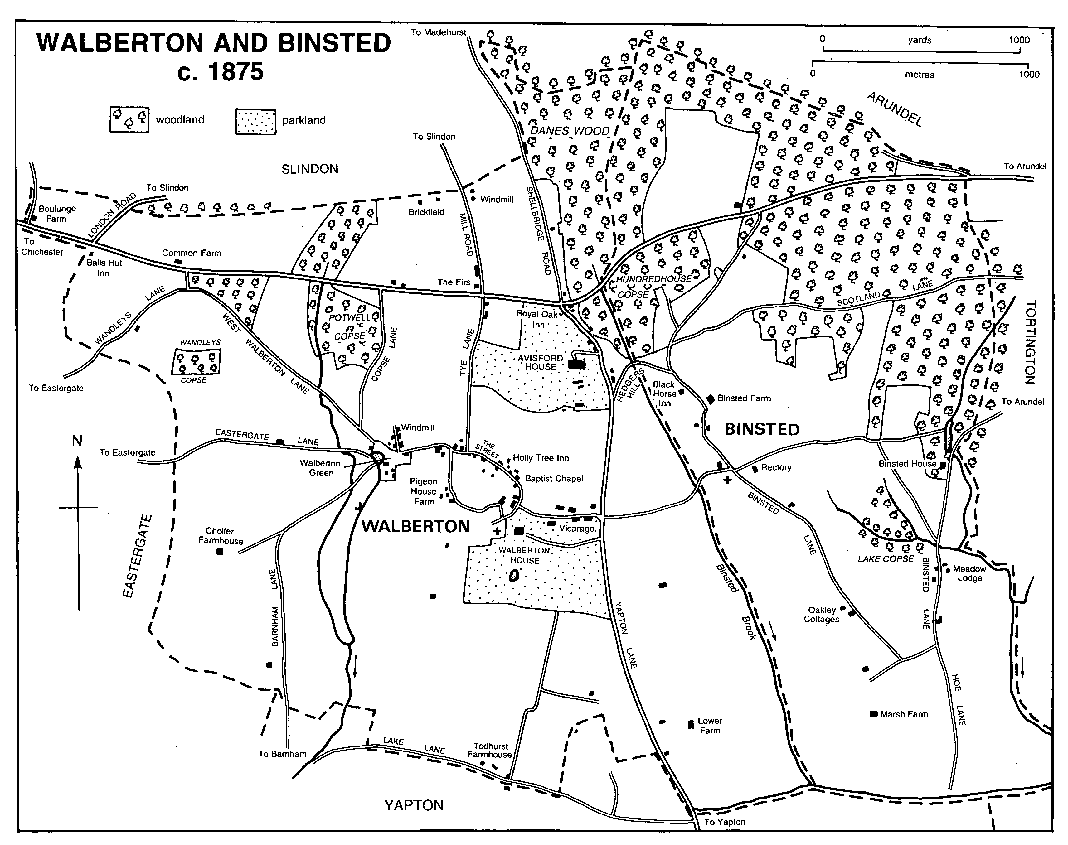
WALBERTON AND BINSTED c. 1875
In 1630 the centre of the modern village was partly settled, but most houses and crofts lay at the eastern end and in a back road running west from a point near the church (fn. 51) which survived in 1994 as a footpath. In 1756 there were c. 9 houses in the eastern section of the Street, including the vicarage, and c. 17 in the central section between the church and the modern Dairy Lane, where close spacing in adjacent narrow plots may indicate a planned layout. The back road then had 10 or 11 buildings. (fn. 52)
Among several 18th-century buildings is the so-called Dower House, formerly Park House, (fn. 53) a double-pile structure of c. 1750 perhaps including parts of an earlier building (fn. 54) and with 19th-century and later additions. At Pigeon House farm is a probably 18th-century round dovecot of flint with brick dressings. (fn. 55) Early 19th-century houses in the Street include the stuccoed Myrtle cottage and Jessamine cottage of grey and red brick.
In the 1840s there were 35-40 dwellings between Dairy and Yapton lanes, but by then the back road had ceased to be of much importance. (fn. 56)
At the western end of the modern village street Walberton green was a separate focus of settlement until the early 20th century. The surnames Westeton and Westcote recorded in 1327 (fn. 57) may refer to dwellers in that area, which may also be the West Walberton mentioned in 1740. (fn. 58) The thatched Friars Oak and Friars Oak cottage south-east of the green comprise a 17th-century timber-framed building enlarged on the west in the 19th century and faced with painted brick. Another possibly timber-framed house on the north side of the green once had 17th-century mullioned windows; (fn. 59) it was refaced in brick and flint apparently in 1763 (fn. 60) and was derelict in 1995. Adjacent to the last named was formerly a building with a five- or six-bayed brick front also in 17th-century style with a plat band between the storeys. (fn. 61) Six houses were depicted at the eastern end of the green in 1756. (fn. 62) Barrack Row to the east is a brick terrace whose name, recorded from 1851, apparently does not allude to military use. (fn. 63) In the 1840s there were c. 7 houses around the green besides others, including a windmill, in Mill Lane to the east. (fn. 64)
Some gaps along the village street were filled by new buildings in the mid 19th century, notably an imposing brick house near Tye Lane dated 1865 which perhaps belonged to the farmer and maltster Richard Suter. (fn. 65)
In the 1880s and 90s several terraces of flint, brick, and stone, including re-used medieval ashlar, were put up on the south side of the central part of the street by the builder and dairy farmer W. E. Booker. (fn. 66) Two incorporate older buildings, one with a datestone for 1681; another, which includes the post office, has Norman-style arched windows and a terracotta portrait medallion commemorating Queen Victoria's jubilee of 1887. Booker also built pairs of semidetached houses on the east side of Dairy Lane after 1896. (fn. 67) The artisan character of the new terraces contrasted strongly with the seigneurial eastern end of the village lying between the enlarged parks belonging to Walberton House and Avisford House. The Dower House at the same date was a gentleman's house, with well laid out grounds that included a tennis lawn. (fn. 68)
Infilling continued during the 20th century. (fn. 69) Council houses were built from 1920 (fn. 70) and by the mid 20th century formed a large estate west of Dairy Lane. (fn. 71) Two working farms remained in the village in the early 20th century, Pigeon House farm and Street farm near Walberton green. (fn. 72) By 1950 a road of detached houses had been built at the east end; (fn. 73) a close of houses and bungalows was put up nearby before 1963, (fn. 74) and a street of luxury dwellings north-west of the church c. 1974 (fn. 75) on land first offered for building in 1918. (fn. 76) North-east of the church a bend in the Street was straightened in 1957 and a shopping parade constructed. (fn. 77)
New dwellings were also provided in the 20th century by converting former business premises, (fn. 78) the manor house, its outbuildings, and the old National school. (fn. 79) Some older houses latterly divided into cottages were restored for single occupation. A copy of a medieval 'Wealden' house was put up in 1987. (fn. 80)
Already in 1972 too much new building was felt to have occurred too fast, giving Walberton a partially suburban character. (fn. 81) By 1990 incomers, many of whom did not stay long, were the dominant group. (fn. 82)
Building land was offered for sale near Walberton green from 1902, (fn. 83) and the settlement there was linked with the rest of the village by new building during the 20th century. There are three 20th-century houses north of the green, and a close of new houses at the south-east corner. By the mid 20th century 20-25 houses had been constructed beyond the green along the road to Barnham. (fn. 84)
A second centre of settlement in the parish was at Avisford in the north-east corner. The name evidently refers to a crossing of the Binsted brook on the Walberton-Binsted boundary. Roman finds north of the Chichester-Arundel road and west of Shellbridge Road, including glass and earthenware vessels, suggest occupation there in the 1st century A.D. (fn. 85) In the Middle Ages Avisford was important as the centre of the hundred. (fn. 86) It was mentioned as a place c. 1217, when a windmill was to be built there. (fn. 87) The name Avisford Hill described the steep incline from the Binsted brook to the site of the present Royal Oak inn; (fn. 88) an alternative name for the high ground in that area was Beacon Hill. (fn. 89)
There were at least two cottages on waste land at Avisford in 1609, (fn. 90) though nothing was depicted in 1630. (fn. 91) By 1778 there were c. 6 houses between the Royal Oak and the junction of Yapton Lane and Hedgers Hill leading to Binsted, some apparently on sites reclaimed from roadside waste; (fn. 92) beside Hedgers Hill itself stands Beam Ends, a small, probably 17th-century, timber-framed building originally only two rooms wide, which seems also to have been built on waste land. Similar in scale and probably in date was a cottage on the east side of Yapton Lane opposite Avisford House demolished in the late 19th or early 20th century. (fn. 93) The elaborate nos. 1-3 Yapton Lane is an L-shaped mid 19th-century building of varied materials, with scalloped bargeboards and gabled dormers; in 1883 it belonged to the Avisford House estate. (fn. 94)
West of Avisford where Tye Lane reached Walberton common lay a cluster of houses (fn. 95) which may be Tye Lane End mentioned in 1769. (fn. 96) After the inclosure of the common and the realignment of the Chichester-Arundel road in the latter year, (fn. 97) large houses could be built nearby to take advantage of the fine coastal views available from the high ground. Besides Avisford House mentioned below, Hill cottage at the north end of Tye Lane and Firgrove on the corner of Mill Road, formerly the Firs, existed by 1778; (fn. 98) the latter is an L-shaped 18th-century house with a three-bayed south front and 19th-century or later additions and alterations including a ballroom at the east end. (fn. 99) Woodlands to the west was built before 1813. (fn. 100)
More dwellings were put up nearby from the late 19th century; for instance, building land was offered for sale in 1883 between Mill and Shellbridge roads, (fn. 101) along both of which stand big 20th-century houses. (fn. 102) In 1994 the north-eastern part of the parish, with its woods, straight roads, and predominantly recent buildings, and with the open Slindon common beyond, suggested wildness only lately tamed.
In the north-west corner, on the border with Eastergate, lies the hamlet of Fontwell. The place name is recorded in 1630, (fn. 103) and the cottage built on the manor waste 'near the west woods end' before 1598 may have been there. (fn. 104) A house called Common Farm (fn. 105) near the junction of the Chichester-Arundel road with West Walberton Lane existed by 1778, (fn. 106) but the present building, afterwards renamed Goodacres, is of the early 19th century and stuccoed. The three-bayed house called Days, formerly Boulunge Farm and intermediately the Hermitage, (fn. 107) was apparently built in 1778 (fn. 108) and is faced with Roman cement. There are one-storeyed extensions at both ends, that on the west of brick with a reset early 16th-century stone doorcase, and that on the east rendered like the house but with windows in Gothick style. Pieces of medieval to 18th-century stonework, some moulded, are used as kerbstones along the north-south track which follows the parish boundary immediately to the west. All were presumably brought to the site by the owner A. J. Day. (fn. 109)
Merryvale cottage, off Arundel Road, of three bays, was 18th- or 19th-century; it survived in 1962 (fn. 110) but was later demolished. Park cottage in London Road, of flint and brick, was derelict in 1992.
There were c. 6 dwellings in all at Fontwell in the 1840s. (fn. 111) Land was offered for building between the Chichester-Arundel road and Wandleys Lane in 1893. (fn. 112) By 1910 the name Fontwell was used to describe the area around the Hermitage, (fn. 113) but as new houses were built further east in the 1920s and 30s, both along the Chichester- Arundel road and north of it (fn. 114) the name was extended to include those. A bypass road was constructed in 1988. (fn. 115)
The remainder of the parish had scattered dwellings before the mid 19th century. (fn. 116) The former Choller Farmhouse off the road to Barnham, embodying a medieval open-field name, (fn. 117) is an 18th- or early 19th-century building faced with Roman cement. Todhurst Farmhouse on the southern border, probably contemporary, also commemorates an open-field name. (fn. 118) It was called Southwood Farm in 1813. (fn. 119) There were two or three more houses nearby in Lake Lane in 1778, as well as others along West Walberton Lane and three in the southern part of Yapton Lane which evidently occupied land reclaimed from roadside waste. (fn. 120) Walberton Farmhouse east of Yapton Lane is apparently a 19th-century building with Edwardian additions, and Wanley House near Fontwell is of c. 1900.
Several older houses besides the two great mansions of the parish were occupied by gentry families in the late 19th and early 20th centuries, including Choller and Todhurst Farmhouses. (fn. 121)
Land near Barnham station in the south-west was offered for building in 1902 (fn. 122) but not then developed. During the 20th century there has been much building along rural roads, notably Yapton Lane east of the village, Lake Lane in the south, and West Walberton, Wandleys, and Copse lanes north-west of the village; (fn. 123) in the latter area detached houses and bungalows, some large, occupy a woodland setting. In Eastergate Lane are houses constructed for nursery workers. Much building dates from the 1920s when Walberton's population almost doubled; (fn. 124) the pace of development increased again after c. 1950.
Thirty-nine people were assessed to subsidy in Walberton in 1327 and 46 in Walberton and Barnham together in 1332 (fn. 125) and in 1524. (fn. 126) Twenty-one 'inhabitants' and 14 servants and other residents were recorded on the manor in 1624. (fn. 127) In 1642 the protestation was signed by 61 parishioners, (fn. 128) and in 1670 the number assessed to the hearth tax was 47 with 5 discharged. (fn. 129) Fifty-five people were listed in the Compton census in 1676 (fn. 130) and there were 49 families in 1724. (fn. 131) From 502 in 1801 the population rose to 687 in 1821, but then fell to 561 by 1841, partly through temporary absence but mainly through emigration or transfer to the workhouse. (fn. 132) Thereafter it remained between 578 and 628 until 1911. In the 1920s it almost doubled because of residential development, and it continued to increase thereafter to 1,485 in 1951, 1,792 in 1971, and 1,916 in 1991. (fn. 133)
Communications.
The Roman road from Chichester to Brighton crossed the north end of the parish roughly on the line of the modern Chichester-Arundel road. (fn. 134) Avisford bridge, evidently on the Binsted boundary, was mentioned in 1553 (fn. 135) and Mackrells bridge near Potwell copse in 1630. (fn. 136) Before 1769 the road ran further south between Potwell copse and the Royal Oak inn at Avisford, (fn. 137) its present straighter course being fixed at inclosure in that year. (fn. 138) The section in the east end of the parish became a dual carriageway in the late 1960s, when the steep descent from the Royal Oak was embanked and made more level. (fn. 139) The rest of the road within the parish was made a dual carriageway, and a bypass for Fontwell was constructed, in 1988. (fn. 140)
Walberton village itself is the focus of roads and tracks from several directions. (fn. 141) The road to Eastergate existed by 1229; (fn. 142) it was called Eastergate Lane in 1756, when Barnham and West Walberton lanes were also named. (fn. 143) Tye Lane, i.e. the road leading to the common, was called Tyle Lane in 1635 and later; (fn. 144) it was the Arundel road in 1615. (fn. 145) Yapton Lane existed by 1608; (fn. 146) the section north of Walberton village street was known as Hole Lane in 1756 and later. (fn. 147) The road formed part of the Arundel-Bognor road in 1849. (fn. 148) Lake Lane along the southern boundary of the parish was called Shipley Lane from 1756 (fn. 149) but had its present name by 1819. (fn. 150) The road to Binsted was called Hedgers Hill by 1851, (fn. 151) evidently from a surname recorded a century earlier. (fn. 152)
Other roads south of the Chichester-Arundel road were Todworth or Todder Lane in the south-east mentioned in 1615, (fn. 153) Choller Lane in the south-west mentioned from 1635, (fn. 154) Wandleys Lane near Fontwell recorded by 1724 (fn. 155) and called Wandlass Lane in 1756, (fn. 156) and Copse and Puck lanes recorded from 1756, the latter running south from Pigeon House Farm. (fn. 157)
Tracks across Walberton common in the north to Slindon and Madehurst (fn. 158) became the straight London, Mill, and Shellbridge roads at inclosure in 1769. (fn. 159) London Road was part of the Balls hut to Storrington turnpike road between 1812 and 1880; (fn. 160) from 1988 it formed part of the Fontwell bypass road.
There were several carriers (fn. 161) in Walberton between the mid 19th century and the early 20th. For most of that period the Burches and the Bowleys successively offered a carrying service from the Holly Tree inn in the village; in 1886 Allan Bowley plied twice weekly to Chichester and another carrier daily to Arundel and Barnham. (fn. 162) Arundel was still served in 1915, Chichester in 1922, and Barnham in 1938. The firm of C. W. Burch were haulage contractors from 1938 or earlier. (fn. 163)
The Bowleys also provided horse-drawn passenger transport to Barnham and Arundel stations by 1886. (fn. 164) In 1927 motor buses went to Arundel, Bognor, Littlehampton, and Worthing, and by 1934 to Chichester. (fn. 165) The parish was unusually well connected by bus services in 1992, when Storrington and Guildford could also be reached.
Between 1846 and 1864 Walberton was served by Yapton station at its south-eastern corner. (fn. 166)
An alehouse keeper was recorded in 1596 (fn. 167) and an unlicensed tavern in 1641. (fn. 168) The Anchor alehouse, adjacent to or including a smithy in 1677, (fn. 169) has not been located but may have been the inn with one guest bed and stabling for one horse recorded in 1686. (fn. 170) Two inns outside the village were recorded from the mid 18th century. Balls hut at Fontwell had that name from 1756. (fn. 171) There was a smithy there c. 1832 (fn. 172) and the publican in 1852 was a wheelwright. (fn. 173) Badger baiting was an attraction during the 19th century. (fn. 174) In the early 20th the inn was popular with cyclists (fn. 175) and in the mid 20th with coaches and day trippers. (fn. 176) It was renamed the Fontwell in the 1980s but was demolished in 1992 after the building of the Fontwell bypass. The Royal Oak at Avisford existed by 1756 (fn. 177) but its name is not recorded until 1808; (fn. 178) the building has two stories and three bays and is apparently early 19th-century. The Avisford hundred view was generally held there in the earlier 19th century (fn. 179) and in 1861 an annual New Year's eve ball. (fn. 180) In 1886 there was a large room where over 100 could dine, picnics and beanfeasts as well as teas and dinners being hosted. (fn. 181) The Holly Tree inn in the village street was recorded from 1845 (fn. 182) and so called in 1867. The building was refurbished in the later 19th century. (fn. 183) In 1886 it offered accommodation for visitors, including families. (fn. 184) Both the last named inns survived in 1994.
Social and cultural activities.
An unusual variety of social and cultural facilities was available in Walberton in the 19th century and early 20th, mostly provided or supported by resident landowners and clergy. A parish library for Walberton and Yapton was formed c. 1810 with subscriptions from local gentry; the books were to be chosen by the vicar and kept at Walberton vicarage. (fn. 185) In the second half of the 19th century there were two libraries, one at the vicarage and the other, founded by Mrs. Reynell Pack, at Avisford House. (fn. 186) Thomas Vogan, vicar from 1843, started the annual Walberton and Yapton flower, fruit, and vegetable show in 1856; it was still held in 1867. (fn. 187) His wife meanwhile ran a clothing club, (fn. 188) and in the early 20th century there was a coal club, also apparently founded by the incumbent. (fn. 189)
A club and reading room, with books, magazines, and games, was started in 1883; it occupied part of the former tithe barn of the vicarage, and in 1888 was open six nights a week in winter with a good attendance. (fn. 190) A new village hall of timber was erected in 1909 towards the eastern end of the Street at the expense of Mrs. Long of the Firs; though intended for general village use it always belonged to the church. There was a rifle range there, (fn. 191) and a Walberton miniature rifle club flourished between 1913 and 1920. (fn. 192)
The name Maypole field attached in 1847 to a close east of the Holly Tree inn (fn. 193) presumably alludes to past revelries. There was a cricket club by 1869, which used part of the field in 1889; a pavilion was erected in the following year. (fn. 194) In 1922 and presumably earlier the field belonged to the Avisford House estate. (fn. 195) A 6-a. close north of the cricket ground was sold to the parish council in 1928 for recreation. (fn. 196) Walberton green was also used for recreation including cricket and boxing by the late 19th century. (fn. 197)
A short-lived Walberton bonfire society was mentioned in 1905. (fn. 198)
W. G. Hunter, vicar 1915-37, patronized the village hall, the flower show, the boys' club, and the cricket and football clubs. (fn. 199) Since the 1970s, with the influx to the village of many outsiders, social organizations have proliferated, including clubs for badminton, stoolball, and table tennis, an operatic society, and a decorative and fine arts society. The Walberton horticultural society had 419 members in 1994. (fn. 200) The village hall was replaced in the 1980s by a building of brick and flint near the recreation ground.
The mission room at Fontwell was used for dances, youth club meetings, and other social events after 1930. (fn. 201) A community centre called Fontwell hall was opened in Arundel Road in 1989. (fn. 202)
Public services.
Water in the past was provided by wells, which in dry weather in the late 19th century could be supplemented from the pond at Walberton green. (fn. 203) The Bognor Water Company constructed a reservoir in the north-west corner of the parish at Fontwell before 1910, and under an agreement of that year laid mains and supplied Walberton village street throughout its length. (fn. 204) Main drainage was installed from 1960. (fn. 205) Gas reached the village in 1903. (fn. 206) Avisford House had its own electricity supply in 1922, (fn. 207) and by c. 1937 the Bognor Gas and Electricity Company provided electricity more generally. (fn. 208) There was street lighting in the village from c. 1948. (fn. 209)
The high ground near Avisford was apparently a beacon site in the early 17th century or before. (fn. 210) An encampment of 'Clubmen' at Walberton in 1645 was dispersed by c. 50 horse and foot sent from Arundel castle, two 'malignant ministers' being captured and one person killed. (fn. 211)
The Prince Regent and Mrs. Fitzherbert visited Gen. John Whyte at Walberton House in the early 19th century. (fn. 212) Walberton was affected by the Swing riots of 1830, which Richard Prime of Walberton House had a hand in quelling. (fn. 213)
In 1988 a CARE community for the mentally handicapped moved from Petworth to a 20-a. site in Eastergate Lane. In 1989 there were 27 residents, each with a cottage. (fn. 214) A nursing home off Yapton Lane accepted both long- and shortstay patients in 1991.
MANOR AND OTHER ESTATES.
The manor of WALBERTON was held in 1066 by three free men, and William held it of earl Roger in 1086. (fn. 215) Perhaps from that date and certainly from 1200, when Olive de St. John was dealing with it, (fn. 216) it descended as a member of Halnaker in Boxgrove (fn. 217) in the St. John and Poynings families, generally passing with Barnham (fn. 218) or Middleton, (fn. 219) other members of Halnaker, until 1429. (fn. 220) After the death in that year of Thomas Poynings, Lord St. John, (fn. 221) Walberton passed, like Halnaker, successively to his widow Maud (d. 1453) for her life, (fn. 222) to John Bonville, son of their granddaughter Joan (fn. 223) (d. 1494), and then to John's son-in-law Thomas West, (fn. 224) later Lord de la Warr, who with his wife Elizabeth gave both manors in 1540 to the Crown as part of an exchange. (fn. 225)
Members of the Racton family leased the Walberton demesnes between 1526 (fn. 226) and 1609 (fn. 227) or later. In 1611 the manor was granted by the Crown to Simon Stone, (fn. 228) after whose death in 1615 (fn. 229) his executors sold it in 1616 to Thomas Bennet (fn. 230) (created Bt. 1660; d. 1667). Bennet's son Levinus (fn. 231) with his wife Judith sold it in 1677 to Richard Nash, (fn. 232) a member of a family recorded in the parish since 1630, (fn. 233) who had perhaps been living in the manor house in 1670. (fn. 234) Richard was succeeded in 1680 or 1681 by his son John (fn. 235) (d. 1732), whose heir was his nephew Richard. (fn. 236) At Richard's death 1790 (fn. 237) × 1794 he was succeeded by his son Gawen Richard, (fn. 238) who in 1801 conveyed Walberton to Gen. John Whyte. (fn. 239) After Whyte's death in 1816 (fn. 240) his son and heir Alexander sold it in 1817 to Richard Prime; (fn. 241) by that date the estate comprised over 1,400 a., (fn. 242) remaining about the same size in the mid 19th century. (fn. 243)
Richard Prime, a strong Tory (d. 1866), was M.P. for the western division of Sussex 1847-54 and the dominant figure in Walberton in his day. His son and heir (Capt.) Arthur (d. 1883) devised the reversion of the estate to his five illegitimate children. (fn. 244) Thereafter the manor house was let or unoccupied until in 1903 the estate was sold by Prime's trustees to Joseph Liddle, who lived at Walberton (fn. 245) until his death in 1930. (fn. 246) Part of the land was sold to the Avisford House estate in the early 20th century or before: Walberton farm in the south-east part of the parish (250 a.) by c. 1910, (fn. 247) Lower farm (72 a.) by 1917, (fn. 248) and Todhurst and Pigeon House farms (313 a.) between 1918 and 1922. (fn. 249)
By 1938 Walberton House and perhaps the remaining estate had passed to Liddle's son-in-law Percy G. Heywood. (fn. 250) In 1954 the house and c. 160 a. were bought by Frederick James Marquis, Viscount and later earl of Woolton (d. 1964), who resumed the Primes' role of squire; (fn. 251) after the death of his son and successor Roger in 1969 the house was again sold. (fn. 252)
There was a manor house at Walberton by 1302. (fn. 253) It or its successor was presumably either the house with nine hearths where Capt. Richard Nash lived in 1670, or that with seven where Thomas Nash lived at the same date. (fn. 254) The building which existed before the modern one stood north of the site of that and faced the lane to the church; it had a main front of late 17th-century character with seven bays, the central three recessed. Its south front as depicted in 1790 had a central Venetian window and flanking two-storeyed canted bays all apparently belonging to a mid 18th-century refacing. A lower range to the east shown in 1790, presumably accommodating service uses, may have incorporated earlier work. (fn. 255) The house in 1756 was approached through a walled forecourt entered from the lane to the church. (fn. 256)
Walberton House was rebuilt and greatly enlarged c. 1803 by Gen. Whyte, apparently to his own designs. Partly because of faulty construction, (fn. 257) it was replaced in 1817-18 by Richard Prime with a larger building on a new site designed in plain Greek Revival style by Sir Robert Smirke. (fn. 258) Of asymmetrical plan, it consisted of a main south-facing range of seven bays and an east-facing one of three bays. A one-storeyed Doric colonnade ran along the south and west fronts, and an octagonal entrance hall also of one storey was recessed in the south-east angle between the two main ranges. Two service ranges running north (fn. 259) were curtailed between 1910 and 1950. (fn. 260) The western section of the colonnade and the eastern bay of its southern section were removed c. 1960, (fn. 261) and at some point the entrance hall was replaced by a smaller lobby. In the early 1980s the house, renamed Walberton Park, was split into five apartments, the grand staircase hall, library, and dining room remaining undivided. At the same time a north-west wing containing eight more apartments was added in matching style. (fn. 262)
A garden was mentioned in 1362. (fn. 263) In 1756 large formal gardens adjoined the then manor house to south and south-east, including two square-plan areas each with diagonal paths and a round pond; there were then also shrubberies and a kitchen garden. (fn. 264) In 1902 the new house had two walled kitchen gardens, with a cucumber house, mushroom house, and vinery. (fn. 265) The former stables to the north were reconstructed for domestic use c. 1930 and from c. 1970 formed two dwellings called in 1993 Manor Lodge and West Manor Lodge. A new house called Walberton House was built in 1983 in the kitchen gardens; of low profile, it is topped by an 18thcentury cupola brought from Farnham (Surr.). (fn. 266)
The hide less a yardland held of Walberton manor by Rolland in 1086 has not been identified, but if within the parish presumably lay in the north-east since the yardland had been incorporated since 1066 in Arundel Great park. (fn. 267)
Thomas Fowler (d. 1772) (fn. 268) had manorial freeholds totalling 88 a. in 1747 (fn. 269) on which before 1756 he built what became AVISFORD HOUSE; (fn. 270) his son and namesake sold the house and 80 a. in 1780 to William Halsted, (fn. 271) from whom it had passed by 1787 to Adm. (Sir) George Montagu, later commander-in-chief at Portsmouth. (fn. 272) In 1811 Montagu sold the estate to Gen. Sir William Houston, and by 1819 it had grown to c. 120 a. (fn. 273) Apparently in 1834 and certainly before 1838 it passed to (Lt.-Gen.) Sir Thomas Reynell, Bt. (d. 1848), (fn. 274) and in 1847 it comprised 142 a. (fn. 275) Thomas's widow Lady Elizabeth Reynell and their son-in-law Sir John Anson, Bt., were living at the house in 1851-2, but at Elizabeth's death in 1856 the estate passed to her son Lt.-Col. Arthur John Pack, who added the surname Reynell in 1857 and died in 1860. His widow and heir Frederica Reynell Pack and their son Arthur D. H. H. Reynell Pack (fn. 276) sold it in 1883 to William H. Boswall Preston, (fn. 277) whose heir Thomas H. Boswall Preston conveyed it in 1892 to (Lt.-Col.) C. P. Henty. (fn. 278) He enlarged the estate by buying Walberton farm in the south-east corner of the parish (250 a.) before c. 1910 (fn. 279) and the adjacent Lower farm (72 a.) by 1917. (fn. 280)
In 1917 or 1918 Henty sold the estate, by then c. 650 a. in Walberton and Eastergate, to Edgar C. Fairweather. (fn. 281) He further enlarged it before 1922 to 1,385 a., for instance by the purchase of Todhurst and Pigeon House farms (313 a.), (fn. 282) and was still one of two chief landowners in the parish in 1927. (fn. 283) From 1928 until 1973 Avisford House was used as a Roman Catholic boys' preparatory school which had 60-90 pupils. (fn. 284) In 1976 it was bought with c. 40 a. by Mr. Tony Pagett-Fynn for conversion to a hotel and country club; (fn. 285) he sold it in 1994 with 62 a. to Stakis PLC. (fn. 286)
A house at Avisford existed by 1756. (fn. 287) Its appearance then seems likely to be represented by a drawing of 1790 showing a main northfacing block of nine bays and two storeys with a hipped roof, and service outbuildings to the east. (fn. 288) The site had been chosen for its wide view of the coastal plain including the Isle of Wight. The house was enlarged in the mid 19th century, notably on the south-west. (fn. 289) Much interior redecoration is probably of that date; it includes a one-storeyed billiard room on the south front and the stone main staircase with cast-iron balustrading. In 1883 the ground floor also had a domed entrance porch, a conservatory, a library, and a dining room with French windows to a paved colonnade; on a mezzanine floor were two communicating drawing rooms facing south and west, the latter with a domed ceiling. (fn. 290) Extensive additions were made for the hotel after 1976, raising the number of bedrooms by 1994 to 126 and incorporating large facilities for leisure activities and conferences. (fn. 291)
There were pleasure grounds, a kitchen garden, and a shrubbery in 1756. (fn. 292) The kitchen garden lay south of the house in 1847, (fn. 293) and in 1883 there were two vineries, besides rhododendrons and evergreen shrubs around the house. (fn. 294) By 1922, when the pleasure grounds were described as fully mature, there were glasshouses and a bamboo garden. (fn. 295) The walled kitchen garden and one vinery survived in 1995.
The RECTORY estate, including woodland called Hiefalde, two thirds of the great tithes, and rents from free and villein tenants, belonged to Boxgrove priory between the 12th century and the Dissolution; (fn. 296) it was valued at £12 in 1291 (fn. 297) and leased in the 1530s (fn. 298) and presumably before. It was granted by the Crown in 1561 to the bishop of Chichester (fn. 299) and regularly leased thereafter, for 21 years in 1570 (fn. 300) and for three lives after that, the lease descending between 1760 and the mid 19th century with the manor. (fn. 301) By 1839 the estate comprised only tithes, including some from Yapton. (fn. 302)
Small areas of land in Walberton belonged in the Middle Ages to the dean and chapter of Chichester cathedral, (fn. 303) Tortington (fn. 304) and Shulbrede priories, (fn. 305) and apparently Barnham chantry. (fn. 306)
In 1847 the only estates in Walberton more than 40 a. in area which did not belong to the two chief landowners were in the north: 101 a. owned by William, George, and John Halsted (fn. 307) and 84 a., chiefly woods, belonging to John Abel Smith of Dale Park in Madehurst. The Dale Park estate continued to own land in the north part in 1883. (fn. 308)
ECONOMIC HISTORY.
Agriculture.
Walberton manor demesne farm had three ploughs in 1086, and six servi. (fn. 309) It continued to be the chief farm in the parish until the 17th century. In 1302 there were 341 a. of arable and 5 a. of meadow, (fn. 310) and in 1362 there were 318 a. of arable and 10 a. of meadow besides pasture for cows, sheep, and apparently horses; (fn. 311) in the mid 15th century the arable was expressed as four ploughlands. (fn. 312) In 1543 the farm was leased for 21 years (fn. 313) and in 1580 for three lives; in 1609 it had 309 a. (fn. 314) and in 1630 it had 351 a. (fn. 315) Already by 1543 there were at least 163 a. of demesne land besides, leased to others; (fn. 316) by 1630, evidently through engrossing, the total was nearly 300 a. (fn. 317)
In 1756 the manor demesnes seem to have included three chief farms worked from houses in or near the village street, the two largest belonging to the buildings later called Park House (the modern Dower House) (363 a.) and Friars Oak (186 a.) at Walberton green. (fn. 318) About 1817 the Walberton House estate included Home or Pigeon House farm (289 a.), Choller farm (261 a.), 'East farm' (188 a.), Common farm at Fontwell (186 a.), Todhurst farm (125 a.), 'Walberton Street farm' (79 a.), and an unnamed holding (151 a.); Home and East farms were held together, as were Choller and Common farms. (fn. 319) In 1847 there were five chief holdings: Pigeon House or Dairy farm (187 a.), Choller and Common farms (429 a.), Todhurst farm (140 a.), the modern Walberton and Lower farms (248 a.), and an unnamed farm attached to a house near the Holly Tree inn (67 a.). (fn. 320) Other farms of 142 a. and 97 a. were worked at the same date from Avisford House and Woodlands in Arundel Road respectively. (fn. 321)
There were 19 villani and 13 cottars on Walberton manor in 1086, (fn. 322) and in 1302 there were 10 free tenants, 23 customary tenants, all but one holding a single yardland, and 19 cottars. Each customary tenant then rendered 1½d. at Michaelmas and a hen or hens, and owed work service every day except Sundays and feast days at harvest time, and five days a month during the rest of the year. (fn. 323)
The cottars' lands were apparently later regarded as copyholds. (fn. 324) By 1609 eight freeholders had estates of up to 38 a., totalling perhaps less than 100 a. in all; of the 32 copyhold tenants many had a single yardland (14-16 a.) and some one and a half or two yardlands. All copyholds in 1609 were held for lives. (fn. 325) There had been some rationalization by 1630, when six freeholders had estates of between 5 a. and 46 a. and 17 copyholders estates of between 6 a. and 37 a.; at that date there were also 10 cottagers. (fn. 326) Some freehold and copyhold tenements lay in Yapton in 1543. (fn. 327) By 1555 at least one tenant was a non-parishioner. (fn. 328) Copyholds could be sublet by 1594. (fn. 329)
By the mid 18th century, evidently after much enfranchisement, there were c. 20 freeholders and c. 8 copyholders besides other tenants of uncertain status; four freeholds were over 40 a. in area but copyholds were smaller. (fn. 330) In the absence of manorial records after the later 18th century the further process of enfranchisement is unclear.
On the hide less a yardland held of Walberton manor by Rolland in 1086 there were two villani and four cottars, (fn. 331) while Boxgrove priory's rectory estate had two or more villeins in the 1180s. (fn. 332) By 1204 at least one freeholder held of the priory, (fn. 333) and there were more freeholders later. (fn. 334) In 1630 the former Boxgrove lands lay in two holdings of 47 a. and 65 a. which were considered as freeholds of Walberton manor. (fn. 335) Sawyers Dean, comprising 60-80 a. including woodland in the north-east, belonged to Ford, Climping, and Ilsham manor. (fn. 336)
Open fields lay scattered around the central and southern parts of the parish in the Middle Ages: (fn. 337) the Hempshard, (fn. 338) the Gaston or Garston, (fn. 339) and the Sinder or Sinders north and north-east of the village centre; Stone Lee and Pendall or the Pendolls east of Yapton Lane; the Todder, Tedworth, or Todhurst in the south; Puthurst east of Barnham Lane; and the Chollers, Chalder, or Choleworth, (fn. 340) and the Breach, Beech, or Birch (fn. 341) west of it; the name of the latter suggests reclamation from waste land. (fn. 342) Prestcroft, described as near Avisford in the early 13th century, may have lain along Mill Road, (fn. 343) while the Tye, mentioned in the Middle Ages and later, presumably lay beside the common. (fn. 344) Northeldfield recorded in 1404 (fn. 345) and the Rye hammes mentioned in the early 17th century (fn. 346) are unlocated, though the latter presumably lay on poorer soil suitable for rye. It is not clear whether the Furze field mentioned in 1556 was an open field. (fn. 347)
Parts at least of the fields had been inclosed by 1543, when closes of between 5 a. and 25 a. were mentioned in four of them. (fn. 348) By the early 17th century most of the fields lay in parcels of between 2 a. and 8 a. which were either long and narrow or roughly square, each manorial tenement continuing to have land in various areas of the parish. (fn. 349) Some land formerly open arable had by then been converted to pasture, a trend that continued later. (fn. 350)
There was common meadow in the lowerlying south-west and south-east parts of the parish. Eastmead or the East meads east of Barnham Lane was mentioned c. 1291 (fn. 351) and Westmead or the West meads west of the same road in 1609. (fn. 352) Broadmead (fn. 353) and Little meads (fn. 354) mentioned from the 16th and early 17th century respectively have not been located, but the former may be partly represented by the Pendolls mead and Withy mead in the southeast mentioned in 1630. (fn. 355) In the early 17th century the home farm, copyholds, and freeholds all had parcels in those common meadows, mostly under 2 a. in area. (fn. 356)
The chief common pasture was Walberton common in the north, which abutted Eastergate and Slindon commons. It is not clear whether it offered the grazing for oxen, cows, and pigs to which Boxgrove priory was entitled in the mid 12th century. (fn. 357) In 1609 it was divided into East heath and West heath, each of 80 a., (fn. 358) the division apparently being made by the land called Mackrells brooks, the modern Ashbeds wood, which existed as a demesne inclosure apparently by 1585. (fn. 359) Two other inclosures had been made by 1630 at the western end: (fn. 360) pasture and woodland called the Wenlasse or Wandlass between the modern Wandleys and West Walberton lanes recorded from 1543 (fn. 361) and land west of Wandleys Lane called the new inclosure. The 18 demesne closes called the Heath crofts totalling 32 a. apparently represent intakes along the southern edge of the common. (fn. 362) In 1630 and in 1756 two areas in the west and north-east respectively were disputed with Eastergate and Slindon manors; judgment in each case was evidently given against Walberton, since the areas concerned remained outside the parish. Shellbridge common in the northeast corner named in 1630 had presumably been commonable in the Middle Ages by tenants of Shulbrede priory. (fn. 363)
In 1609 tenants of Walberton manor could put all sorts of cattle on the East heath, while sharing the West heath with tenants of other lords. (fn. 364) Overstocking and illegal encroachments were presented in the 1590s; in 1598 grazing rights were fixed at three beasts, two horses, and 20 sheep for each yardland. (fn. 365) Encroachments were still controlled in the 17th and 18th centuries. (fn. 366) In 1769 the common comprised 256 a. The lord of the manor was then entitled to at least four fifths of the grazing either as lord or as owner of former manorial tenements; others who had rights included Thomas Fowler of Avisford House and the vicar. Since, however, those rights had apparently been very little exercised for a long time and the common was of little advantage to any of the commoners it was inclosed in that year, the lord receiving 120 a. at the west end, the vicar 7 a. on the Slindon boundary, and 23 other parties allotments of between 1 a. and 20 a. (fn. 367)
Walberton green at the west end of the village where roads diverged to Barnham, Eastergate, and Fontwell is recorded from 1585. (fn. 368) In the 17th century it extended further south-east than later. (fn. 369) Nothing is known of grazing rights before the late 19th century when villagers seem to have had free use of it. Fences were erected c. 1890 to prevent access by gypsies, and the grazing was let by the manor estate at a nominal rent; grazing continued until the mid 20th century and most of the fencing remained in 1994. (fn. 370) Sheep were washed in the pond on the green in the 19th and early 20th centuries. (fn. 371) The green was registered as a village green in 1967, the registration becoming final in 1971. (fn. 372)
Walberton manor in 1086 had 14 a. of several meadow, (fn. 373) but the 100 a. of pasture mentioned in the 15th century (fn. 374) may describe Walberton common. Several meadow in later centuries included the demesne close called the Tithing mead (3 a.), the first cut from which was usually awarded to the vicar c. 1630 in lieu of tithe hay. (fn. 375) Several demesne pasture included the Best pasture (18 a.) north of Lake Lane. (fn. 376)
Crops grown in 1341 included hemp, flax, apples, and pears; sheep, cows, pigs, and geese were then raised. (fn. 377) In the 17th and 18th centuries wheat was the most common crop, others regularly recorded being barley, oats, peas, beans, hemp, tares, and vetch. (fn. 378) Hops were apparently grown in 1644. Buckwheat was mentioned in 1687, clover seed in 1748, (fn. 379) and turnips in 1776. (fn. 380) Cattle, sheep, and pigs were widely kept in the same period; at least three farmers before 1700 had flocks of over 100 sheep, and one in 1726 had 476. Geese, hens, ducks, and a turkey were mentioned on one holding in 1670. (fn. 381) All the copyholds recorded in 1609 had much more arable than several pasture, presumably because tenants then still used the common wastes. (fn. 382)
In the first half of the 19th century arable remained dominant: in 1819 most of the parish was said to be under crops (fn. 383) and in 1847 there were over 1,100 a. of arable to 325 a. of meadow and pasture. (fn. 384) Wheat was still the chief crop in 1801, (fn. 385) when there were no fatting oxen, apparently 784 sheep, and 235 pigs. (fn. 386) Steam cultivation was possibly introduced c. 1860, and in 1881 for the first time most corn was cut by machinery. (fn. 387) In the mid 19th century many parishioners worked as labourers for the seven or eight landowners, of whom the most important were resident; some in 1867, however, worked in Madehurst. (fn. 388) A shepherd, a cowherd, and a cow keeper were recorded in 1851. (fn. 389)
By 1875, though arable remained important, with returns of 624 a. of wheat, barley, oats, and peas and 294 a. of other crops, the area of grassland had increased to c. 500 a., 1,218 sheep and lambs being listed. (fn. 390) The Avisford House home farm in 1883 had a small area of arable, and grazing meadow and park pasture highly suitable for both fattening cattle and dairying. (fn. 391) There was one dairy farmer by 1887, two in the early 20th century, and a pig dealer in 1895. (fn. 392) Arable acreage returned had dropped to 721 a. by 1909, when that of grassland had risen to 670 a. and the largest corn crop was oats. At the latter date there was seven times as much rented as owner-occupied land, five holdings having between 50 a. and 300 a. and one more than 300 a. (fn. 393) On the Walberton House estate in the early 20th century were Pigeon House and Todhurst farms, held together as 313 a. in 1918, and Choller farm, of 173 a. in 1902, (fn. 394) while the Avisford House estate included Walberton and Lower farms in the south-east corner and Wandleys farm in the north-west in the 1910s. (fn. 395) In 1922, when there were a dairy farm and a stud farm on the Avisford House estate, much of its agricultural land was in hand. (fn. 396) Most farms in the early 20th century practised mixed agriculture. Todhurst and Pigeon House farms in 1918 were claimed to produce very heavy corn crops, and the Avisford House estate ran a successful sheep flock and Shorthorn herd in 1922. After 1923 Pigeon House farm was centred on its dairy herd, which increased beyond the carrying capacity of the farm so that cattle were driven up to 20 miles afield for summer grazing. Sheep, pigs, and poultry were also kept there at that time. (fn. 397)
Allotment land west of Walberton green was let to the parish council by the owners of Choller farm in 1917. (fn. 398) After c. 1918 the county council as landowner let 205 a. in the south-west corner of the parish as smallholdings; in 1920 seven were of 5 a. or less and six others between 10 a. and 49 a. (fn. 399) There were eight smallholders in 1938 (fn. 400) and some remained in 1995. (fn. 401) There was a poultry breeder in 1922 and there were two in the 1930s. (fn. 402)
In 1985 holdings listed in the parish emphasized pasture farming rather than arable, among stock returned being 551 cattle kept chiefly for milking and 3,794 head of poultry, mostly hens for laying. Of the non-horticultural enterprises analysed two were specialist dairy holdings and one mainly so. Most land was evidently worked from farms outside the parish. (fn. 403) Pigeon House farm in 1995 had 160 a., chiefly arable with some grassland used by dairy cattle from Barnham Court farm. (fn. 404) Choller farm at the same date kept both dairy and beef cattle together with milking ewes; it comprised 76 a. with another 90 a. of grazing in other places. (fn. 405)
Market gardening.
A market gardener was recorded in 1851 at Fontwell, and parishioners described as gardeners at the same date may have been involved in the same activity. (fn. 406) Half an acre of orchard was listed in 1875. (fn. 407) The baker Harry Hartley was a fruit grower too by 1895; his nursery was at the east end of the village street and had seven glasshouses on its 1½ a. in 1904, but it seems to have ceased to exist soon afterwards. (fn. 408) John Goodacre founded a market-gardening business at Fontwell by 1899, (fn. 409) also growing fruit by 1910. (fn. 410)
In 1909 there were 2 a. of small fruit and c. 3 a. of orchards in the parish. (fn. 411) The industry expanded greatly in the 1930s, and in 1938, besides Goodacres, there were a fruit grower, four nurserymen, and a firm called Todhurst nurseries, occupying land along Eastergate Lane in the west and Barnham and Yapton lanes in the south. (fn. 412) The site of Goodacres nursery was later largely built over. (fn. 413)
There was further expansion after the mid 20th century. The 26 ha. (64 a.) of horticultural crops listed in 1985 included 17 ha. of vegetables grown under glass and 2 ha. of orchards and small fruit. Eight general horticultural holdings and one chiefly involved in fruit growing were returned in that year, when market gardening evidently accounted for most of the 374 people listed as working on the land. In 1993 market gardens and glasshouses, some producing flowers, continued to occupy much land between Yapton and Lake lanes in the south and around Eastergate and Barnham lanes in the west. (fn. 414)
Mills.
Mill tithes from Walberton were taken by Tortington priory in the Middle Ages. (fn. 415) There seems to have been a water mill in the south-west corner of the parish, where a field name Mill mead is recorded in 1630 and later; (fn. 416) that may have been the ruined water mill mentioned in 1609. (fn. 417) About 1217 Boxgrove priory was granted land in a field called Prestcroft near Avisford to build a windmill; (fn. 418) the site may be that of the later mill in Mill Road. The other later windmill site east of Walberton green may also have been in use by 1565 when the surname Westmill was recorded. (fn. 419) There were two mills during the 19th century, (fn. 420) a post mill at Avisford (fn. 421) and a smock mill at Walberton green. (fn. 422) The occupiers of both were also bakers c. 1832 (fn. 423) and often later. (fn. 424) Charles Gardiner of the mill in Mill Road farmed 25 a. in 1851. (fn. 425) That mill had gone by 1896; the other had then apparently ceased to be used (fn. 426) and was demolished, except for part of its base, soon afterwards. (fn. 427)
Fair.
In the later 19th century a 'gypsy fair' was held on 29 May at the Royal Oak inn and there were horse sales on Sunday afternoons at Walberton green. (fn. 428)
Other trades and industries.
Trades specifically mentioned or suggested by surnames in the Middle Ages were those of carpenter, (fn. 429) wheelwright, and smith. (fn. 430) Additional occupations recorded between the 16th century and the late 18th were mostly connected with food, (fn. 431) clothing, (fn. 432) and building or construction. (fn. 433) The site of the forge mentioned in 1537 (fn. 434) is not known, but may have been at the junction of the village street with Yapton Lane where there was a smithy by 1635. (fn. 435) In 1677 a forge stood next to an alehouse which may have been on the site of the Royal Oak inn at Avisford or Balls hut at Fontwell. (fn. 436) A shovel maker was mentioned in 1671. A wheelwright in 1753 had a shop in Slindon as well as one in Walberton. (fn. 437) There was a weaver in 1674 (fn. 438) and a maltster from 1713. (fn. 439) A mason who died c. 1676 did business with people in Barnham, Felpham, and Slindon, and made loans to inhabitants of Arundel, Barnham, Madehurst, and Yapton. (fn. 440) Two parishioners were charged with coining in 1597. (fn. 441)
Three bricklayers were recorded between 1642 and 1727 (fn. 442) and a brickmaker in 1751. (fn. 443) A close called Brick kiln field in 1756 lay east of Walberton House, (fn. 444) but the chief later brickmaking site was in the north, west of Mill Road. (fn. 445) Five parishioners worked in brickmaking in 1851 (fn. 446) and many in 1867. (fn. 447) The site near Mill Road was still active in 1874 but was disused by 1896. (fn. 448) Clay and gravel have been dug elsewhere in the north part of the parish in the 19th and 20th centuries, notably in Danes wood. (fn. 449)
In the 19th and early 20th centuries there was an unusually high proportion of people in the parish earning their living otherwise than by agriculture: between 1811 and 1831 roughly one in three of those in work. (fn. 450) The smithy at the junction of the Street and Yapton Lane was active throughout the period, (fn. 451) and there was another in the village centre in 1847 (fn. 452) and in the early 20th century. (fn. 453) Wheelwrights and carpenters included members of the Lintott family at Walberton green, (fn. 454) the Suters, one of whom repaired threshing machines in the 1850s, (fn. 455) and the Sergants, who were also builders. (fn. 456) Some parishioners worked in the woods in 1867 (fn. 457) and the licensee of the Holly Tree inn was a wood merchant in 1886. (fn. 458) There was a cabinet maker from 1918. (fn. 459)
There were also generally at least two grocers or drapers in the same period. (fn. 460) John Humphrey began his grocery business in 1861; in 1898 he was described besides as draper, butcher, tea and provision merchant, and dealer in china, glass, earthenware, ironmongery, boots and shoes, and patent medicines. By then his premises had three separate units for the grocery, drapery, and butcher's operations. (fn. 461) Humphrey's stores were still run by members of the family in 1965, (fn. 462) but afterwards closed.
A brewery existed at the east end of the village by 1800; (fn. 463) it belonged to Messrs. Ellis and Farnden c. 1832 (fn. 464) but from 1845 to the Ellis family alone. (fn. 465) It was closed in the 1920s. (fn. 466) The buildings were extensive, with a tall brick chimney. (fn. 467)
William Booker (d. 1900) (fn. 468) began his career as a bricklayer's labourer, but after taking over the stock in trade of Thomas Caiger in 1858 became a stonemason (fn. 469) and later a builder and contractor and dairy farmer. The building business was continued in the family until the 1990s (fn. 470) and was responsible for construction at Barnham market, Fontwell waterworks, and Bognor isolation hospital. (fn. 471) About 1890 up to 27 men were employed. By the late 19th century the firm also dealt in funerals and house decoration, and in 1913 they were hire carters, and gas, water, and sanitary engineers. (fn. 472)
Other less common trades recorded in the parish during the 19th and early 20th centuries were those of glazier, painter, (fn. 473) plumber, (fn. 474) tinplate worker, (fn. 475) photographer, (fn. 476) coal merchant, (fn. 477) corn merchant, (fn. 478) horse and cattle dealer, stationer, and fishmonger. (fn. 479) Several dressmakers and a female tailor lived in Walberton in 1851. (fn. 480) There was an artist in 1862, a firm of engineers and machinists in 1874, a cycle agent in 1918, a motor engineer in 1927, and a garage in 1934. (fn. 481)
Domestic service employed many throughout the same period; in 1851, for instance, the household at Avisford House totalled 19. One gamekeeper was recorded in 1841 and two in 1851. There were eight laundresses in 1851. (fn. 482)
The growth of motoring after the First World War led to the opening of refreshment rooms by 1922. The timber-framed Beam Ends in Hedgers Hill was a tea garden by 1938 (fn. 483) and after reopening c. 1990 also offered bed and breakfast. (fn. 484) There were two other guest houses in Walberton in 1993. In addition, the Avisford Park hotel and country club, opened in 1976, expanded greatly thereafter: by 1985 it served the conference and management training markets as well as tourism and had two squash courts, a swimming pool, and a 9-hole golf course. (fn. 485) In 1990 it employed 90 staff. (fn. 486) In 1991 a self-contained hotel and business centre under the same ownership, with a banqueting hall seating 350, was opened to the south. (fn. 487) In 1994 the hotel, renamed Stakis Arundel, had 126 beds. (fn. 488)
A riding school flourished in 1938. (fn. 489)
There were an accountant and a physician and surgeon in 1927, and a midwife in 1934. An estate agent practised in 1938. (fn. 490)
Already by 1955 many residents worked outside the parish, some at Ford naval air station and others in London. (fn. 491) The number increased greatly after that date.
In 1993 shops and other businesses in the village street included two general stores and newsagents, a hardware and garden shop, a shop selling curtains, a hairdresser, a launderette, and a garage. There were also a solicitor, an estate agent, and a doctor's surgery.
At Fontwell the Dean family ran a construction firm from 1935 which was responsible for much building in the parish, though by 1974 it did most of its business in Arundel. (fn. 492) A shopping parade was opened in 1939. (fn. 493) At first there were a butcher, a grocer, a haberdasher, and a newsagent, (fn. 494) and the post office moved there from its previous site near Fontwell racecourse in 1968. (fn. 495) The wine merchant, the saddler, and the business selling guns and fishing tackle which flourished in 1992, however, chiefly served passing traffic. Fontwell's roadside location also brought successive cafés and garages or petrol stations. (fn. 496) Two small factories had arrived north of the settlement by 1957, (fn. 497) and by 1991 the Orchard Way industrial estate had 21 units, mostly accommodating firms in building or related industries. (fn. 498) The construction of the bypass road in 1988 reduced custom for Fontwell's businesses, (fn. 499) but by 1993 a new restaurant, motel, and garage had been built beside it. There was also a medical centre in 1992.
Outside the village and Fontwell hamlet in 1993 there were two small business estates in Tye Lane and Lake Lane; a firm of horticultural engineers, a timber yard, (fn. 500) and a mixed industrial site in Arundel Road; and a garage and a garden machinery business in Yapton Lane.
LOCAL GOVERNMENT.
Leet jurisdiction was successfully claimed for Walberton manor in 1279, (fn. 501) but in the early 16th century was the subject of controversy between Lord de la Warr as lord of the manor and the earl of Arundel as lord of the rape. After arbitration in 1520 the Walberton view of frankpledge was defined as inferior to the hundred courts, the earl retaining 'the suit royal of the headboroughs and their tithings'. (fn. 502) There was a headborough for Walberton and Barnham together in 1293; (fn. 503) in 1536-7 he attended the hundred court but apparently only as a formality. (fn. 504) A bailiff served in 1543; (fn. 505) the earl of Arundel held the office in 1546. (fn. 506)
There are court records for the years 1594-9 (fn. 507) and 1623-1772. (fn. 508) In the 1590s a view of frankpledge was held usually once a year and a court baron usually twice. Besides the standard business of regulating land transactions, managing common land, and controlling nuisances, the view held the assize of bread and of ale, oversaw highway repair, and heard at least one case of assault and another of trespass. Sometimes business normal to the view was done at the court instead. A pound was mentioned in 1596; (fn. 509) it was perhaps the one in the Street still apparently used to store roadmen's materials in 1964, (fn. 510) which was restored as a garden c. 1982. (fn. 511)
Between 1623 and 1641 a view and court were held annually in autumn; (fn. 512) the pattern continued less regularly during the rest of the 17th century, the last view being held in 1686. In 1685 and 1747 the tenants and their holdings were listed in full. In the 18th century there were never more than two courts in a decade, business being treated out of court by 1755. Fines for committing nuisances were still collected in the late 1640s, but at the last view the only business was the election of a headborough. A bailiff still served in 1623 and there was an under-constable in 1633.
Two churchwardens were recorded generally between 1548 and 1681 and from 1774, but in the intervening period there was almost always one only. (fn. 513) There were two overseers by 1642. (fn. 514) Waywardens served in the 19th century (fn. 515) and presumably earlier. The parish clerk received £3 a year in 1817. (fn. 516)
In 1643 payments were made to widows for keeping their own or others' children and to one old man who was bedridden. (fn. 517) Other methods of poor relief used during the 18th century and early 19th included weekly pay; apprenticing; the provision of clothing, flour, fuel, and medical care; and help with rent, burial expenses, and in time of illness. (fn. 518) The parish owned and apparently let out bedding in 1720. (fn. 519) From the 1780s it had a share in the Gilbert union workhouse at Yapton. By 1832 there were also four parish cottages for the use of poor people; (fn. 520) they stood at Walberton green (fn. 521) and were sold c. 1839. (fn. 522)
A hundred and forty-seven parishioners were receiving permanent relief in 1825-6, and 86 casual relief. (fn. 523) In 1832 a doctor received £16 a year to attend the poor. During the years around 1830 the occupiers of land agreed to employ all the parish labourers in numbers proportionate to their land-tax assessments. (fn. 524) In the early 1830s at least 29 paupers were helped to emigrate, chiefly to Canada under Lord Egremont's scheme; a third of the expense was defrayed by landowners, with the rest to be paid from the rates within four years. (fn. 525)
In 1835 Walberton joined Westhampnett union, later rural district, and from 1933 it was in Chichester rural district. (fn. 526) After 1974 it was in Arun district.
The parish council looked after the pond on Walberton green from 1894 and after 1951 was owner of the green. (fn. 527) From 1917 it leased 1 a. west of the green from the owners of Choller farm for allotments. (fn. 528) In 1928 C. E. Stern sold to the council 6 a. east of the Holly Tree inn for a recreation ground. (fn. 529)
CHURCH.
There was a church in 1086. (fn. 530) In 1105 Robert de Haye, lord of Walberton, gave it to Lessay abbey (Manche), (fn. 531) from which it passed to the abbey's priory of Boxgrove. A vicarage was ordained c. 1174-80. (fn. 532) The living was united to Yapton between 1753 and 1875. (fn. 533) In 1929 Walberton was united with Binsted as the united benefice of Walberton with Binsted, the parishes remaining distinct. (fn. 534)
The advowson of the vicarage belonged to Boxgrove priory from c. 1174-80 (fn. 535) until the Dissolution, the Crown presenting in the 14th century during the war with France and the bishop of Chichester for a turn in 1505. (fn. 536) In 1558 the Crown granted the advowson to the bishop, (fn. 537) who presented until the early 20th century, except in 1709 when the Crown presented (fn. 538) and 1802 when the archbishop collated. (fn. 539) In 1929 the patronage of the united benefice was agreed to be shared between the bishop and the patrons of Binsted in the proportion of two turns to one, but from the mid 1980s the bishop alone was patron. (fn. 540)
The church had been endowed before 1086 with two yardlands, (fn. 541) and c. 1160 Boxgrove priory was confirmed in possession of William de St. John's gift of 11 yardlands at Walberton with grazing for 12 oxen, 12 cows, and pigs. (fn. 542) At its ordination c. 1174-80 the vicarage was endowed with offerings and a third of all tithes. (fn. 543) In 1291 it was valued at £10. (fn. 544) In 1440 the living was augmented with the rest of the tithes of the parish in return for a yearly payment to Boxgrove priory of 10s.; (fn. 545) the pension was still paid in 1535, (fn. 546) but the arrangement was evidently later rescinded, since in 1635 and later the vicar was entitled to only a third of the corn tithes, and hay tithes only from certain closes; however, in 1635 he also received all the tithes of 39 closes called holibreads and a third of corn tithes from c. 150 a. in Yapton. (fn. 547) Tithes from Walberton which had been granted by the St. John family to the abbey of La Lucerne (Manche) were resumed in 1162, (fn. 548) and mill tithes paid to Tortington priory in the Middle Ages are not heard of again, (fn. 549) but a portion of Walberton tithes descended with Bilsham manor in Yapton in the 16th and 17th centuries. (fn. 550) Both the rectorial and vicarial tithes were let in 1700. (fn. 551)
The living was worth £8 or less in 1440, (fn. 552) and its net value in 1535 was £10 18s. 10d. (fn. 553) In 1573-4 the income seems to have been enjoyed by the farmer or farmers of the rectory estate, (fn. 554) but by 1579 the vicar had it again. (fn. 555) The living was valued at £49 5s. 10d. in 1724 (fn. 556) and at £80 in 1750; (fn. 557) c. 1830 the average net income of the united benefice of Walberton and Yapton was £468. (fn. 558)
The glebe was originally scattered closes. In the early 17th century there were an orchard and 1 a. south of the vicarage house, 3 a. in the Todder open field, 5-8 a. called Heath croft lying west of Tye lane, and 1-3 a. of meadow in Westmead next to Barnham lane, (fn. 559) besides a 3-a. close called the Tithing mead in the south-east corner of the parish granted by the manor tenants in lieu of tithe hay. (fn. 560) In 1724 there were 14 a. of arable and 5 a. of meadow or pasture. (fn. 561) In 1743 Heath croft, then reckoned as 10 a., was exchanged with Thomas Fowler and his trustees for 6 a. in the Todder and 4 a. in Westmead. (fn. 562) At the inclosure of Walberton common in 1769 the vicar was awarded 7 a. on the Slindon boundary. (fn. 563) In 1849 the outlying portions in the south-east and south-west (21 a.) were exchanged with the lord of the manor for a compact block west of Tye Lane, and the close in the north with members of the Halsted family for 4 a. east of Potwell copse; the vicar also received ¼ a. north-west of the vicarage house for giving up a right of way across the manorial demesne. (fn. 564)
A vicarage house was mentioned in 1411 (fn. 565) and was in poor condition in 1573. (fn. 566) It presumably occupied the same site as the later vicarage house on the south side of the village street, which in 1615 had two outhouses and a carthouse. (fn. 567) Rooms mentioned in 1644 were hall, parlour, kitchen, and three chambers. (fn. 568) The building called in 1995 the Old Vicarage has at its core a possibly 18th-century two-storeyed section of brick including the present entrance hall and a single-storeyed wing to the east. In 1757-8 after the union of the livings of Walberton and Yapton the vicarage house at Yapton was demolished and that at Walberton rebuilt; (fn. 569) the two-storeyed range on the west side perhaps belongs to that date. Robert Hardy, vicar from 1802, (fn. 570) spent over £1,000 on improving the building before 1812. It remained too small, however, and apparently in that year he added a drawing room along the south side with a bowed western end (fn. 571) and perhaps the staircase as well; as a result the house was said in 1819 to have been nearly rebuilt. (fn. 572) In 1862 one end of the former tithe barn was converted into a coach house and stable and the other into a large room for parish purposes. (fn. 573) Further additions and alterations were made to the house c. 1875; (fn. 574) the present drawing room with south-facing canted bay seems to be of that period. The house was sold before c. 1980 (fn. 575) but remained in single ownership in 1995; meanwhile a new brick building was put up to replace it on the north side of the village street.
At the commutation of tithes in 1847 Richard Prime as lessee of the rectory estate received £313 3s. tithe rent charge besides £4 15s. payable from the glebe when not occupied by the vicar. The vicar received £362 7s. 6d. together with £1 9s. 2d. in lieu of vicarial tithes from the glebe close (7 a.) in the north part of the parish. (fn. 576)
The vicar in 1411 was excommunicated for the partial castration of a chaplain of Slindon. (fn. 577) His successor resided in 1440. (fn. 578) A later vicar was reported in 1538 for speaking against the Crown's expropriation of Church funds. (fn. 579)
The vicar resided in 1563, (fn. 580) but a successor in 1574 was often absent. (fn. 581) From the early 17th century several vicars held other local livings, (fn. 582) though they generally seem to have resided. (fn. 583) Curates were mentioned on occasion in the early 17th century and in the 18th and mid 19th centuries; one at least succeeded as vicar. (fn. 584) The curate in 1706 apparently lived in the vicarage house. (fn. 585)
Henry Jordan, minister in 1661, was ejected in the following year. (fn. 586) In 1724 the incumbent himself held morning and evening services with sermon on alternate Sundays; at that date communion was celebrated four times yearly to 30 or 40 communicants. (fn. 587)
Michael Dorset, the first incumbent of the united benefice of Walberton and Yapton, served for 52 years and also held three other livings. (fn. 588) Robert Hardy, vicar 1802-43, a chaplain to the Prince Regent, (fn. 589) addressed earnest pamphlets to his parishioners and founded a parish library. (fn. 590) His successor Thomas Vogan (fn. 591) increased the number of Sunday services to two and introduced monthly communion; (fn. 592) in 1845 he incurred local disapproval because of High Church practices. (fn. 593) Attendances on Census Sunday in 1851 were 150 in the morning and 140 in the afternoon, in each case with 24 Sunday schoolchildren besides. (fn. 594) A parish orchestra was abandoned in or before 1857, (fn. 595) but by 1865 there was a choir instead. (fn. 596) Communion services were held c. 30 times a year by 1884 and weekly by 1903. (fn. 597) In 1995 there were two or three Sunday services and holy communion on Fridays.
A mission room at Fontwell was built in 1930 on a site given by the Goodacre family. Services were held at least weekly (fn. 598) but the room was closed at some time after 1957. (fn. 599)
The church of ST. MARY (fn. 600) consists of chancel and aisled nave with north porch. The walls are of flint rubble, including some Roman tile, with ashlar and brick dressings. A timber bell turret is surmounted by a shingled spire. The early history of the building has been obscured by extensive restoration and rebuilding in the 18th, 19th, and early 20th centuries.
During the later 12th century two-bayed north and south arcades were cut into the eastern end of the possibly pre-Conquest nave; a gable cross which may have been pre-Conquest was discovered in the west wall c. 1903. (fn. 601) The chancel was built early in the 13th century to a width greater than that of the nave and was given lancet windows; the chancel arch was rebuilt in the 14th century. The stone north porch with trefoil-headed windows was added late in the 13th century, by which time, if not originally, the aisles were as long as the nave. Probably in the 15th century the nave and aisles were re-roofed with a single roof and the bell turret was added. At the same period some refenestration took place, of which only one window in the north aisle and the three-light west window survived into the 20th century. (fn. 602)
The church was in poor condition in 1603; (fn. 603) in 1724 one of the cross beams of the nave roof was said to be ready to fall, (fn. 604) and in 1742 the bell turret, though recently repaired, was threatening collapse. (fn. 605) A west gallery (fn. 606) was erected before 1790, when it was lit by dormer windows on both sides of the church. (fn. 607) In the later 18th century or earlier 19th the south aisle was nearly all taken down and rebuilt with thinner walls of brick and flint rubble, and windows with wooden casements were inserted in the walls of both aisles. (fn. 608) It was perhaps at that time that the large round-headed western arches of the nave arcades were inserted or rebuilt. (fn. 609) Further alterations were made in the 1850s and 60s: the west door was stopped up; the remains of the gallery were removed, apparently together with part of the support to the belfry; and the north porch was restored with new outer and inner archways and apparently shortened. (fn. 610) The west end of the nave was used as a vestry by the late 19th century. (fn. 611)
The chancel was carefully restored c. 1894. (fn. 612) By 1903 the nave was in a dangerous state, probably as a result of the removal of the sub-frame to the belfry and the insertion of the large arches in the nave walls. The architect Richard Creed carried out a drastic restoration in 1903-4, paid for by subscription. Both aisles and much of the nave were taken down and rebuilt, (fn. 613) with new windows to the aisles and external buttresses to the west wall, the belfry support was reconstructed, and both roofs were renewed.
New vestries and a meeting room were constructed within the west end of the church in 1992-3. (fn. 614)
The font in 1776 was square, supported on four columns; (fn. 615) it was replaced in 1843. (fn. 616) The present tub-shaped font was inserted at the 1903-4 restoration after being found in a farmyard. (fn. 617) In 1636 the position of the minister's seat in the chancel rather than the nave made him largely inaudible. (fn. 618) The pews were described as 'very bad' in 1776 (fn. 619) and too high in 1844. (fn. 620) Most fittings in 1994 were late 19th-century or 20thcentury, but a 17th-century communion table then stood at the west end of the north aisle.
Plural bells were mentioned in 1542. (fn. 621) In 1724 there were three dating from between 1572 and 1712; they were recast in 1903, when three more were added. (fn. 622)
The flagon for communion wine was said to resemble an alehouse pot in 1636. (fn. 623) The existing cup, flagon, and patens, all of silver, date from 1718-19. (fn. 624)
A possibly pre-Conquest stone coffin was discovered in 1834 lying across the doorway of the north porch, (fn. 625) and was preserved under the west window in 1976. (fn. 626) The memorial tablet to the Revd. Philip Blakeway (d. 1915) is by Eric Gill. (fn. 627) In the churchyard are three headstones of the later 18th century and earlier 19th with low-relief carvings depicting the fatal accidents of the deceased. (fn. 628)
The registers begin in 1556. (fn. 629) A registrar for Walberton was appointed in 1654. (fn. 630)
NONCONFORMITY.
The shoemaker who stole the pyx and chalice in 1565 (fn. 631) may have been a Catholic sympathizer. One Catholic family was mentioned between 1724 and 1742. (fn. 632) In 1781 there were 10 Catholics, who heard mass at the neighbouring Slindon chapel. (fn. 633)
The Dissenter mentioned in 1676 (fn. 634) was perhaps a Baptist since a Baptist meeting was recorded in 1710, when it belonged to the Kent association of general Baptist churches. (fn. 635) In 1714, when a chapel was registered for worship, it was served from Chichester. (fn. 636) In 1724 there were two general Baptist families and one Presbyterian. (fn. 637)
A Methodist congregation met in a rented room from 1810 (fn. 638) until 1846, when one of the outbuildings of the windmill near Walberton green was registered for worship by the Wesleyan minister at Chichester; the congregation remained part of the Chichester district circuit thereafter. (fn. 639) Attendance was c. 25 in 1851 (fn. 640) and c. 12 in 1884; (fn. 641) services were held in the afternoon at the earlier date and fortnightly in 1891. (fn. 642) The congregation was said to be sustained in 1865 by the influence of one shopkeeper, (fn. 643) and ceased to exist c. 1916, (fn. 644) Walberton Methodists thereafter going to Barnham or Westergate in Aldingbourne. (fn. 645)
Another Nonconformist chapel was founded in 1846 by c. 13 parishioners offended by the High Church practices of the vicar. Under the direction of a minister in Worthing, they met at first in a cottage in the centre of the village, but in 1847 a brick and flint chapel was opened next door. By that date there were c. 22 communicants. (fn. 646) In 1851 there were morning and evening services each attended by 50 people, (fn. 647) and in 1884, when the minister was still non-resident and the congregation described itself as Baptist, half came from other parishes. (fn. 648)
In 1886 (fn. 649) an imposing new chapel was opened, of red and yellow brick, flint, and hung tiles; like the Methodist chapel, it stood at the west end of the village away from the parish church. A baptistry for total immersion was inaugurated in 1900 and in 1905 the building could seat 100. (fn. 650) The former chapel meanwhile was used as the Sunday school until the mid 20th century (fn. 651) but by 1993 had become a garage. In 1903 a local grocer, evidently Henry Humphrey, acted as minister. (fn. 652)
A brick church hall was put up in 1953 (fn. 653) on the opposite side of the street. The congregation, which had 25 members in 1966, (fn. 654) was affiliated to the Fellowship of independent evangelical churches in 1973. (fn. 655) A resident pastor was appointed in 1992 (fn. 656) and in 1993 there were two Sunday services and weekday meetings.
In the late 19th century Salvation Army services were held on Sunday afternoons at Walberton green. (fn. 657) At least one family adhered to the sect in 1903. (fn. 658)
EDUCATION.
A 'poor man' kept an unlicensed school in 1622. (fn. 659)
John Nash, lord of the manor, by will dated 1732 left a schoolhouse and £12 a year for teaching 18 poor children; since the occupier of the schoolhouse was to continue as master the school had evidently existed before. (fn. 660) In 1742 the only subject was reading. (fn. 661) The schoolhouse was demolished c. 1780 and replaced by another building which stood west of the Holly Tree inn. In 1816 both the use of the house and the master's income were being withheld by Gen. Whyte, but the status quo was resumed after his death later that year. The building belonged to the parish by 1847. (fn. 662)
From 1824 the school was a National school. There were 44 boys and 20 girls in 1833 (fn. 663) and 39 boys and 52 girls in 1846-7. (fn. 664) In 1867 there were 59 on the roll, with an average attendance of 45. (fn. 665) Eighteen children were still taught free in 1833 (fn. 666) and in the mid 19th century some pupils came from Yapton and Barnham. (fn. 667) In 1833 the master received £18 5s. a year (fn. 668) and in 1846-7 there was also a paid mistress. In the latter year additional income was received from subscriptions; (fn. 669) 20 years later the lord of the manor Arthur Prime was making up the shortfall, then £40-50, (fn. 670) and using his resulting influence to choose the teachers. (fn. 671)
A new school building of red brick was put up as Walberton and Binsted National school in 1874 (fn. 672) apparently at the expense of Arthur Prime; (fn. 673) it consisted of a schoolroom and a classroom. Average attendance was under 40 until c. 1880, (fn. 674) rising to 76 in 1884-5, 86 in 1893-4, and 113 in 1905-6. (fn. 675) After a decrease in the 1910s and 20s it was between 128 and 151 in the 1930s. (fn. 676) The rent charge of £12 was redeemed in 1903. (fn. 677) A new infants' classroom was built in 1927. (fn. 678)
The school continued to take pupils of all ages until Westergate secondary modern school was opened in 1958. (fn. 679) A new building for Walberton and Binsted C.E. primary school was built in 1964 north-east of the old one, which was converted into houses. (fn. 680) There were 172 on the roll in 1993. (fn. 681)
Other, fee-paying, schools flourished in the 19th century. Three in 1819 had 25 pupils between them, (fn. 682) and two in 1833 had 53. (fn. 683) In 1851 Mary White kept a small school behind her grocer's shop. (fn. 684) In 1850-1 Miss Pack of Avisford House built a girls' school and school cottage of flint with brick dressings in Gothic style on the north side of the village street near its east end. (fn. 685) In 1867 infants also attended there, the roll totalling 68 with an average attendance of 50. (fn. 686) The school ceased c. 1875, the building becoming a private house. (fn. 687) A private adventure dame school of unknown location was attended by 32 children paying 3d. a week in 1867. (fn. 688) Both the last two schools mentioned, like the National school, took pupils from other parishes, but the vicar nevertheless reckoned that at least 100 Walberton children were being educated. (fn. 689) In 1883 one school catered for children of Dissenters. (fn. 690) Boarding pupils were taken at the vicarage in 1891. (fn. 691)
A night school was held three times a week in winter in 1875. (fn. 692) In the 1890s classes were held in the parish room at the vicarage under the patronage of Lady Anson: girls could learn cooking, laundry work, nursing, and home health, and boys drawing, gardening, and horticulture. (fn. 693)
CHARITIES FOR THE POOR.
John Moorey and John Wyatt in 1625 gave ½ a. beside Lake Lane for the benefit of the poor; it was known as the Poor croft. By 1724 half its income was for church uses; (fn. 694) c. 1835 the total was 10s. a year (fn. 695) and by 1882 £1 distributed in money. (fn. 696) The land was sold in 1925 and the proceeds invested. (fn. 697)
Mrs. Elizabeth Nash in 1716 granted land in Sidlesham, the income to be spent on the poor of various parishes, Walberton receiving £1. The same sum was still received in 1962, but under a Scheme of 1982 the net income from the endowment was re-apportioned, three tenths to go to Walberton which by 1990 received £540. (fn. 698)
The Walberton, Binsted, and West Barnham sick poor fund, succeeding a nursing association for the same places, was set up in 1954, with a nurse's cottage in West Walberton Lane. Its income in the 1990s subsumed those from the two charities mentioned and was spent, among other things, on a ramp for the village hall and in assistance for school journeys. (fn. 699)
William Johnson in 1934 left £300, the income to be devoted to Walberton's sick and poor. (fn. 700)