A History of the County of York East Riding: Volume 3, Ouse and Derwent Wapentake, and Part of Harthill Wapentake. Originally published by Victoria County History, London, 1976.
This free content was digitised by double rekeying. All rights reserved.
A P Baggs, G H R Kent, J D Purdy, 'Hemingbrough: Hemingbrough', in A History of the County of York East Riding: Volume 3, Ouse and Derwent Wapentake, and Part of Harthill Wapentake, ed. K J Allison (London, 1976), British History Online https://www.british-history.ac.uk/vch/yorks/east/vol3/pp37-47 [accessed 2 May 2025].
A P Baggs, G H R Kent, J D Purdy, 'Hemingbrough: Hemingbrough', in A History of the County of York East Riding: Volume 3, Ouse and Derwent Wapentake, and Part of Harthill Wapentake. Edited by K J Allison (London, 1976), British History Online, accessed May 2, 2025, https://www.british-history.ac.uk/vch/yorks/east/vol3/pp37-47.
A P Baggs, G H R Kent, J D Purdy. "Hemingbrough: Hemingbrough". A History of the County of York East Riding: Volume 3, Ouse and Derwent Wapentake, and Part of Harthill Wapentake. Ed. K J Allison (London, 1976), British History Online. Web. 2 May 2025. https://www.british-history.ac.uk/vch/yorks/east/vol3/pp37-47.
In this section
HEMINGBROUGH
The village of Hemingbrough lies close to the river Ouse, about 13 miles south-east of York. The church and no doubt the rest of the early settlement stood on a small area of higher ground approaching the river bank, but the village later extended along a main street running parallel with the river. It was perhaps during the early Middle Ages that the Ouse cut a shorter course at this point across the neck of a wide meander. The old course was abandoned and Hemingbrough subsequently lost the advantages of a riverside site, the river now passing 500 yd. from the southern end of the village. Ancient use of the site is testified by the discovery of Romano-British remains, (fn. 1) and it was presumably the firm ground overlooking the river which attracted the later settlement, a 'stronghold' that may have been either Anglian or Scandinavian. (fn. 2) The township covered 1,141 a. (fn. 3)
Apart from the slightly higher ground at the village site, and an even smaller area just north of the village, the whole of the township lies at less than 25 ft. above sea-level. South of the village the belt of riverside alluvium broadens towards the confluence of the Ouse and the Derwent. The township boundary on the south and west follows the rivers, including the old course of the Ouse, but elsewhere it makes little use of natural features. The relatively small areas of open-field land lay close to the village, with meadows towards the river and extensive early inclosures from woodland in the north of the township. The remaining open fields were inclosed in 1844.
The chief roads in Hemingbrough are those leading north-westwards to Cliffe and eastwards towards Howden. Hagg Lane leads to South Duffield and another minor road to a former ferry crossing the Derwent to Barmby on the Marsh. In the 20th century the Cliffe and Howden roads, together with the streets of Hemingbrough village, became part of the Hull-Selby trunk road, and a bypass around the north-east side of the village was among the many alterations to the road made in the late 1920s. (fn. 4) The Derwent ferry, belonging to the prior of Durham as lord of the manor, was mentioned in 1330 and frequently in the 15th century. (fn. 5) It survived into the twentieth. (fn. 6) Another ferry, across the Ouse, was worked from a farm-house south of the village c. 1930. (fn. 7) In 1850 the old course of the Ouse was followed by a track known as Old Ways Lane, (fn. 8) but this has since ceased to exist. The Hull-Selby railway line, opened in 1840, (fn. 9) crosses the north of the township.
Most of the older village houses lie along the closely-built-up Town Street, their garths stretching back to the 'old' Ouse on the west and to Back and Garth Ends Lanes on the east. Town Street and the back lanes are connected at the north and south ends of the village and also in the centre, near the church, by the old Howden road, known as Finkle Street where it leaves the village. Many of the houses in Town Street are 18th-century in date, most being of brown brick, two storeys high, and with marked plat bands, brick cornices, and projecting kneelers. Three are dated, the Hollies with 1763 inscribed on a keystone, Hoton House with 1751 on a kneeler, and a farm-house in the south of the village with wrought-iron tie-rod anchors for 1754. One later18th-century house, sometimes known as the Old Hall, has a pretentious elevation with the centre bay recessed, raised an extra storey, and surmounted by a pediment. Most of the larger 19th-century houses are in the streets running east from Town Street; they include Manor Farm, which probably incorporates an earlier building, the Chase, the Cottage, the Villa, Hemingbrough Hall, and the former Vicarage. (fn. 10) Smaller 19th-century houses occur in Town Street but it was not until the present century that general development spread into the back lanes; in recent years there has been much new building, including 30 council houses, particularly towards the south and east. The few isolated farm-houses include Wood House in the north of the township and Hemingbrough Grange to the south of the village.
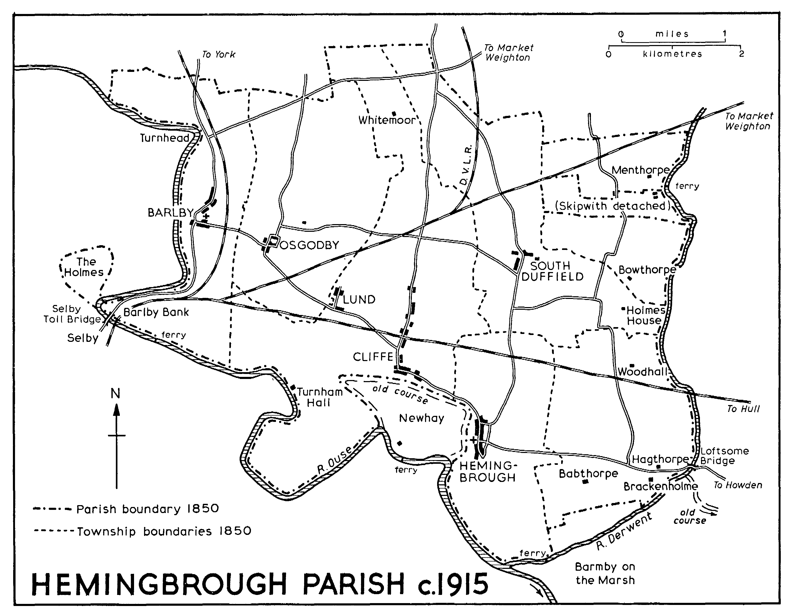
HEMINGBROUGH PARISH c. 1915
The house eventually known as Hemingbrough Hall was built in 1842 by John Ion, vicar (d. 1860), as his own residence; it was at first called Hemingbrough Villa. (fn. 11) The estate passed to Ion's daughter Jane, who married C. G. Tate, and the house was occupied by tenants, William Banks, owner of the Babthorpe estate, living there from 1874 until c. 1930. (fn. 12) It was sold to Fred Wright in 1938 and to George Carr in 1952. (fn. 13) It is a large red-brick house, designed in the Tudor style by Weightman & Hatfield of Sheffield. (fn. 14)
There were between three and five licensed alehouses in the village in the later 19th century, (fn. 15) and in 1823 the inns were known as the Britannia, the Dog, and the Half Moon. (fn. 16) The Dog became the Dog and Duck by 1840 and the Crown by 1872; (fn. 17) together with the Britannia it still existed in 1973. The Half Moon apparently closed c. 1910. (fn. 18)
In 1379 there were more than 150 poll-tax payers in Hemingbrough. (fn. 19) The villagers were granted relief in 1591 after a fire. (fn. 20) Fifty-nine households in the township were included in the hearth-tax return in 1672, six of them exempt. Of those chargeable, 26 had one hearth each, 17 had 2, 9 had 3 to 5, and one had nine. (fn. 21) In the whole parish there were about 300 families in 1743 and about 200 in 1764. (fn. 22) The population of Hemingbrough township in 1801 was 387; it fluctuated for the rest of the century, reaching a peak of 580 in 1871 and standing at 498 in 1901. (fn. 23) Numbers increased to 531 in 1931 and, after the inclusion of Brackenholme with Woodhall in the civil parish, (fn. 24) to 647 in 1951 and 748 in 1971. (fn. 25)
MANOR AND OTHER ESTATES.
Hemingbrough was at first described in Domesday as belonging to the king, but it was given by William I to the bishop of Durham in 1086-7 (fn. 26) and the Domesday Summary showed it as the bishop's property. There were 3 carucates there in 1086, which Tosti had held before the Conquest. (fn. 27) The manor of HEMINGBROUGH was assigned by the bishop to Durham priory, and the manor and mill were worth about £39 just before the Dissolution. Land in Brackenholme, which had all along formed part of the manor, contributed some £2 to that total. (fn. 28)
For unexplained reasons Hemingbrough did not form part of the Durham chapter endowment after the dissolution of the priory, but was kept in hand until it was granted to Sir Arthur Ingram and Martin Freeman in 1614. (fn. 29) It belonged to the Ingrams until the death of another Arthur in 1742, (fn. 30) when it passed to his daughter Isabella, who married Col., later Gen., George Cary (d. 1792). (fn. 31) Hemingbrough passed to Gen. Cary's daughters Elizabeth, who married Sir Jeffery Amherst, and Catherine, later wife of Sir John Russell. They conveyed it in 1802 to Thomas Hartley, Richard Hobson, Thomas Smith, John Tweedy, and Thomas Wilson, who represented the York bankers Wilson & Tweedy. (fn. 32) In 1822 the manor was held in undivided twentieths, five by the devisees of Hartley, four by Smith's devisees, five by Tweedy, and six by Wilson. (fn. 33)
The Smith share belonged to T. R. Smith in 1897, when it was described as 8/40, and it was subsequently held by trustees. (fn. 34) The Tweedy share, described as 15/40 and including half of the Hartley share, passed to John's daughter Sophia, who married James Graham in 1843. They conveyed it that year to William and Joseph Earle, and in 1857 it passed to trustees, one of whom was H. J. Ware, a York solicitor. (fn. 35) The Wilson share, described as 17/40 and including the other half of the Hartley share, belonged to T. W. Wilson in 1853. (fn. 36) It was sold in 1873 and five years later was acquired by H. J. Ware. (fn. 37) Ware died in 1902 and his trustees conveyed his 32/40 of the manor in 1921 to William Ware (d. 1942). (fn. 38)
Before and after the Dissolution the lands in the manor had been held by copyholders and freeholders, and consequently no land was attached to the modern manor. None of the lesser estates has been very large.
A small estate in Hemingbrough belonged to the guild of St. Christopher and St. George, York, and after the suppression was granted by the Crown to York corporation in 1549. (fn. 39)
From 1427 the income of Hemingbrough church, derived largely from tithes, belonged to the college established there that year. (fn. 40) The income subsequently fell, (fn. 41) and a new ordination of the college in 1479 reduced the stipends of the staff. (fn. 42) In 1535 the college was worth about £84 gross. (fn. 43) After the Dissolution various leases were made of rectorial tithes in the several townships, the chief being those to Christopher Salmon in 1548 (fn. 44) and Sir William Babthorpe in 1571 and later. (fn. 45) In 1611 tithes in most of the townships were granted in fee to Francis Morrice and Francis Philips, (fn. 46) but they passed to the Ingrams before 1650 and thereafter descended with Hemingbrough manor. In 1650 the total value was £270, of which Hemingbrough township contributed £50. (fn. 47) Most of these tithes were still held with the manor when they were commuted in the early 19th century. Those in Hemingbrough township were commuted in 1841 for rent-charges totalling £295 payable to Thomas Wilson's devisees, John Tweedy, and Thomas Smith (d. 1841). (fn. 48)
The provosts of Hemingbrough college apparently lived after 1427 in a building later called Prior House, standing in Hall garth, on the south side of the church. (fn. 49) After the suppression of the college it was granted in 1554, along with 30 a. called 'the glebe lands', to Joan and John Constable. (fn. 50) The house eventually passed in 1662 to Sir Jeremiah Smith; it is said to have been demolished in 1697 and the materials used to rebuild Osgodby Hall. (fn. 51) It had nine hearths in 1672. (fn. 52) The Constables were also granted in 1554 the former bedern of the vicars of the college, (fn. 53) which perhaps stood near the provost's house. (fn. 54)
ECONOMIC HISTORY.
In 1086 the 3 carucates comprising Hemingbrough afforded land for two ploughs worked by five villeins and three bordars. There were also 7 a. of meadow, and pasturable woodland ½ league in length and breadth. The value of the estate had fallen from £2 before the Conquest to 16s. at the time of the Survey. (fn. 55) It was later reckoned that, of the 3 carucates, 245 a. were 'old bovates' held in bondage (antique bovate de antiquo bondagio) and 115 a. were demesne bovates tilled by the same tenants. For all the land the bondmen paid rent of 2d. an acre and owed merchet, both before the Conquest to Tostig and afterwards to the king. After the manor was given to Durham priory, however, the bondmen's services were said to have been commuted; thereafter they paid 8d. or 1s. for each 'old bovate', together with 1d. in lieu of services, and 9d. or 1s. for each demesne bovate. (fn. 56)
The extent of the 'old' and demesne bovates together remained unchanged in the 14th and early 15th centuries, though in 1330 their respective acreages were given as 270 and 90. (fn. 57) They were presumably cultivated in common and formed the open-field land of the township, though no 'field' names were recorded until later. Beyond this old arable nucleus the priory had by 1330 reclaimed a further 400 a. of land. Of this about 250 a. lay in various named places and was described in 1430 as 'newly broken up'; several 'assarts' and 'riddings' were among the names. In 1330 the new land was held in small parcels by numerous tenants and some of it undoubtedly became part of the open fields in due course. Other parts of it, however, were eventually held in severalty and contributed to a large acreage of old inclosures in the township. The latter include the modern Haw closes, (fn. 58) which probably represent the 40-acre 'Hawe' of 1330. The assarted land was held at 8d. or 9d. an acre; in addition there still remained about 90 a. in Hemingbrough wood, also held in small parcels, but at a rent of 6d. an acre. A further 53 a. was held by the priest of the Waise chantry and was described in 1330 as waste. (fn. 59)
About 80 tenants were recorded in 1330, of whom 43 held 9 a. or less, 21 held 10-19 a., and 9 held 20 a. or more; the largest holding was about 45 a. Other tenants held the Derwent ferry, the mill, a stall or shop (selda), and the tolls on brewers. (fn. 60) There was no specific mention of fairs or a market, though in 1295 the priory had been granted a Thursday market and a fair on 14-21 August. The total rental of 1330 was over £34, together with nearly £1 from payments in lieu of 'works'. (fn. 61) The profits of the manor were accounted for at Durham by the chamberlain of the priory. In the later 14th century he was charged with rents of about £41 or £42 from Hemingbrough and Brackenholme, as well as over £1 for autumn works. In the 15th and early 16th centuries, however, the 'decay and waste' often amounted to £5 or £6 and included part or all of the rent due from the mill, ferry, and fisheries. The toll-house and a shop under it were several times mentioned in the chamberlains' accounts. (fn. 62)
In 1529, when John West's land in the township was used to endow a chantry, (fn. 63) the open-field land still lay in many different places. The first mention of fields reveals the existence of Water, Near Water, Uttermore Water, Chapel, Mill, and North fields, but West also had many parcels of land elsewhere. Some of the names, like Best plat, Grantacres, the Carrs, Worthorp, and Mortilcroft, had been in the list of assarted lands in 1330. Other arable parcels lay in Harstones in North field and in Somergangs, and there was meadow in Cow ings and 'between dikes'. There were 12 a. of inclosed pasture. (fn. 64) It is not clear whether all of the woodland had been cleared by the 16th century. John West had a small parcel 'in Hemingbrough wood', but among the former chantry property in 1553 was pasture called Hemingbrough wood. (fn. 65) Wood closes were mentioned in 1668. (fn. 66) The former wooded character of the north-east corner of the township is still recalled by the names Hagg Lane and Wood House.
There were apparently no large-scale changes in land use in the township during the 18th century and no revival of the medieval market and fair. A shop which may have been that forming part of the toll-house was granted away by the Crown, separately from the manor, in 1613-14. It may have been the building in the middle of the main street later used as a smithy which was ordered to be removed in 1780. The former fair was succeeded by a village feast, held at about the same time in August, but c. 1780 it was moved to the end of June to avoid harvest time. (fn. 67)
In 1841, just before final inclosure, the township comprised 867 a. of arable land, 173 a. of meadow and pasture, 35 a. of wood and waste, and 18 a. of orchards and gardens. (fn. 68) The remaining commonable lands were inclosed in 1844 under the general Inclosure Act of 1836. (fn. 69) There were found to be 540 a. to deal with, and allotments totalling 517 a. were made. The open fields and meadows were still much fragmented, comprising Chapel field (where allotments of 92 a. were made), Hawse field (13 a.), Mill field (36 a.), Myrtle Croft field (17 a.), Carr field (33 a.), Hearthstone field (7 a.), Between Dikes field (17 a.), Best Plot field (9 a.), North field (46 a.), Old Rudding field (57 a.), the Cringle (6 a.), Stork piece (2 a.), Common Wood field (18 a.), Far field (39 a.), Water field (32 a.), Hornham field (10 a.), Grant Acre field (18 a.), the Marsh (7 a.), and Little Toft field (5 a.); allotments totalling 50 a. were made from more than one area. The 'untilled slips or balks' in the fields had previously been used by the parish officers, who were accordingly allotted 3 a. of Ouse foreshore. There were 3 allotments of 50-99 a., 7 of 10-49 a., and 53 of under 10 a. After inclosure some roadside verges continued to be used in common by the inhabitants: in 1895 47 people were said to have 73 common rights in Hagg Lane, Old Ways, and elsewhere. (fn. 70)
By 1851 few larger farms had been created: there was then one of 200 a. and two of 100-200 a. (fn. 71) There were still only four farms of 150 a. or more c. 1930. The total number of farms in the later 19th and early 20th centuries was usually 12 to 15; in addition half-a-dozen market-gardeners were recorded from the 1870s onwards and a similar number of smallholders after 1920. (fn. 72) The smallholdings were the result of the acquisition of land for the purpose in Hemingbrough and Brackenholme by the East Riding county council. (fn. 73) Land use was still varied in character in the 1930s and later, though arable predominated in the south of the township and grassland in the north. (fn. 74)
In the Middle Ages the manor enjoyed a fishery in the Ouse which brought the priory into conflict with the city of York because fish garths obstructed navigation. (fn. 75) The fishery continued to be appurtenant to the manor after the Dissolution, and a few men made a livelihood from fishing in later centuries. Two Hemingbrough fishermen were mentioned in 1779, (fn. 76) for example, one in 1851, (fn. 77) and one in 1892. (fn. 78) There was a landing-place ½ mile south of the village by 1841 (fn. 79) and 4 a. there were allotted for the purpose at inclosure in 1844. By a Scheme of 1955 it was constituted a charity for the general benefit of the inhabitants. The land was sold in 1956, and in 1972-3 the income of £10 from £181 stock was handed over to the parish council. (fn. 80)
Medieval river traffic may have given employment to a few Hemingbrough men: a mercer and a merchant were mentioned in 1379, for example, and there were also two weavers at that date. (fn. 81) Subsequently few men seem to have followed other than agricultural occupations or the usual village crafts and trades. A glover and a tanner were mentioned in 1624, (fn. 82) however, and a tanner in 1769. (fn. 83) Bricks have long been made at sites north of the village. A string of ponds along Hagg Lane in 1850 was probably the result of digging for clay, and a brick and tile yard already stood near the Cliffe road where it has been worked ever since; (fn. 84) only drainage tiles were being made in 1973.
The manorial windmill at Hemingbrough was mentioned in 1276-7 (fn. 85) and repairs to it were frequently recorded in the Middle Ages. (fn. 86) It was granted away by the Crown separately from the manor in 1609-10 and was frequently recorded thereafter, often in the tenancy of the Howdell family who eventually bought it in 1730. (fn. 87) It was a post mill in 1892. (fn. 88) A miller was last mentioned in 1913 (fn. 89) and the mill, which stood just to the south of the village, had been demolished by 1973.
LOCAL GOVERNMENT.
Various disputes arose in the Middle Ages from the fact that Hemingbrough was deemed ancient demesne of the Crown. In 1291-2, for example, certain tenants alleged that the prior of Durham, as lord of the manor, was not entitled to change their customs and services, as he had done. (fn. 90) In the same year the sheriff apparently upheld a claim that the prior owed suit to his tourns at York, despite the prior's claim that he enjoyed exemption because his own court at Hemingbrough was in ancient demesne. (fn. 91) In 1345 several tenants unsuccessfully contested that the prior should not have sued them in the 'assize' court at York but should have taken the matter to the manorial court, again because of the ancient demesne privileges. Prior and tenants were united in 1430 in opposing the practice of summoning Hemingbrough people to the bishop of Durham's court at Howden. (fn. 92) As tenants in ancient demesne the men of Hemingbrough considered themselves exempt from the payment of tolls, and in 1476 the sheriff was ordered not to distrain upon them for non-payment. (fn. 93) That and other privileges were confirmed to Hemingbrough by the king in 1626. (fn. 94)
Surviving court books for the period 1816-1935 (fn. 95) are entirely concerned with surrenders and admissions.
There are surviving churchwardens' accounts for 1715-1878 which show that all the townships, including Barlby, were assessed to the Hemingbrough rates. There were commonly two churchwardens for Hemingbrough, two for Cliffe with Lund, and one each for Barlby, South Duffield, Osgodby, and Brackenholme, Woodhall, Menthorpe, and Bowthorpe combined. (fn. 96) Hemingbrough joined Howden poor-law union in 1837 (fn. 97) and the nine former poorhouses in the main street were sold by the union in 1866. (fn. 98) The township became part of Howden rural district in 1894, Derwent rural district in 1935, (fn. 99) and the Selby district of North Yorkshire in 1974.
CHURCH.
A church was recorded at Hemingbrough in 1086. (fn. 100) It was given with the manor to the bishop of Durham soon afterwards and assigned by him to Durham priory. (fn. 101) The rectory was a valuable one but the priory received from it only a pension of 5 marks. (fn. 102) Consequently attempts were made in the 14th century to appropriate the church, but papal sanction could not be obtained. (fn. 103) Instead the church was made collegiate in 1427, with a staff comprising a provost, having cure of souls in the parish, three prebendaries, six vicars, and six clerks. (fn. 104) A pension of 5 marks continued to be received by the priory. (fn. 105) Hemingbrough remained in the peculiar jurisdiction of the priory until the Dissolution. (fn. 106) The college was suppressed in 1545 and the church eventually became a vicarage.
The patronage of the rectory and the college belonged to Durham until the suppression, (fn. 107) and subsequently the Crown presented to the vicarage. (fn. 108) A grant of the advowson to the archbishop of York in 1558 (fn. 109) presumably lapsed on the accession of Elizabeth I. In 1898 the advowson passed from the Crown to the archbishop by exchange. (fn. 110)
The living was said by the archbishop in 1290-1 to be worth £166 13s. 4d. (fn. 111) but the church was valued at £110 in the Taxatio of that year. (fn. 112) After 1427 part of the income may have been set aside for the college vicars serving the parish on the provost's behalf. Thus in 1442-3 the provost was discharged from accounting for sales of bread ('halibredesilver') because the parish priests claimed them; (fn. 113) and in 1535 the 'vicarage' was said to be worth £5 7s. o½d. net. (fn. 114) Provision was later made for rectorial lessees to pay £6 13s. 4d. each to a vicar and two assistant curates. (fn. 115) A stipend of £20 a year was allowed to the minister by the impropriators in 1650 (fn. 116) and later. (fn. 117) Parliamentary grants of £200 and £1,600 were received in 1810 and 1814, respectively, (fn. 118) and the average net income of the living in 1829-31 was £85 a year. (fn. 119) Hemingbrough was endowed from the Common Fund with £500 in 1862, £10 a year in 1881, and £13 6s. 8d. also in 1881. (fn. 120) The net income in 1914 was £178. (fn. 121)
Besides his stipend and fees and offerings the vicar in the 18th century received bequests for three anniversary sermons, left by Robert Allen, William Baxter, and Thomas Steele. (fn. 122) There was no glebe land until 1827, when the parliamentary grants were used to buy 37 a. in Hemingbrough; (fn. 123) they still belonged to the vicarage in 1973. (fn. 124)
A parsonage house may have existed in 1324. (fn. 125) The rector may for a time have lived in a house called the Stackgarth, which he rented from Durham priory in 1402-3. (fn. 126) The Stackgarth had in 1339 been assigned by the priory to the priests of the Cliffe chantry, then in course of foundation, and it lay opposite the church next to the Brackenholme road. (fn. 127) The chantry-priests apparently did not use it, however, and after the provost of the college assumed the duties of the former rectors in 1427 the priory frequently had no tenants for the Stackgarth. (fn. 128) The suggestion that it was used as the bedern of the vicars of the college cannot be substantiated. (fn. 129) After the Dissolution nothing is known of the parish priests' place of residence until 1707, when the former Stackgarth was conveyed to trustees for the incumbent's benefit. It was enlarged at the vicar's expense in the mid 18th century but in 1786, when the vicar was non-resident, the house was let to the petty school master. It was partly rebuilt by the vicar in 1794 and repaired by his successor, John Ion, in 1826. (fn. 130) In 1842, however, Ion built Hemingbrough Villa for his own residence (fn. 131) and the need for a house belonging to the living was eventually met in 1862, when a large Vicarage was erected on the Howden road east of the village. (fn. 132) A new Vicarage was built on the Selby road in 1973, (fn. 133) when the 1862 house was known as the Hermitage.
The former Vicarage near the church provided income for the vicar after its disuse. Part of the site was sold in 1854 and the house itself in 1908, and the Old Vicarage Charity had £240 stock in 1938. (fn. 134)
There were four chantries in the church. The Waise chantry was founded by Robert de marisco, rector 1217-18 to 1258, and its establishment by his executors was confirmed by the archbishop in 1274. The endowments comprised a toft near the church, 13 a. of arable and 40 a. of waste in Hemingbrough, about 13 a. in Newhay, and a meadow called Mekelcroft. The chantry is said to have acquired its name from the fact that the toft lay near the Waise or old course of the Ouse. (fn. 135) The chantry was dedicated to St. Catherine. It was worth £6 13s. 4d. in 1535. (fn. 136) Much of the property of this and the other chantries was granted by the Crown in 1553 to John Witherington and Cuthbert Musgrave. (fn. 137)
The Cliffe chantry was founded by the executors of Henry of Cliffe (d. 1332), who devised the residue of his estate to support a chantry in Drax priory. It was nevertheless established, in 1345, in the parish church and was endowed with 2 houses, a mill, and 50 a. of land in Newhay and Rusholme (in Drax), and 7 cottages, 3½ bovates, and about 22 a. in Hemingbrough. There were to be two chantrypriests, and the chantry was to be at St. Mary's altar. (fn. 138) The chantry property, lying in Hemingbrough, Newhay, Lund, Woodhall, Brackenholme, and South Duffield, was worth £6 10s. in 1535. (fn. 139) The Babthorpe chantry, at the Trinity altar, is named after Thomas Babthorpe, who by will dated 1478 bequeathed a vestment to a chaplain who should celebrate there. (fn. 140) The West chantry was founded in 1529 by the executors of John West, incumbent of the Cliffe chantry, at St. Mary's altar. (fn. 141) Its property, lying in Hemingbrough, Newhay, Brackenholme, and Woodhall, was worth £7 6s. 8d. in 1535. (fn. 142)
Miracles were said to be wrought in the church in 1393, when penance for those attending at the Assumption was relaxed. (fn. 143) Statues in the church included those of St. Cuthbert (mentioned in 1348), St. Mary of Pity (1410), and St. Chad (1453). (fn. 144) A chapel of some kind apparently stood to the east of the village on the Howden road. (fn. 145) Chapel field, which took its name from it, was mentioned in 1529. (fn. 146) The chapel was perhaps suppressed in the 16th century and it was later used as a dwelling: a man 'of the chapel at the Chapel field' was mentioned in 1636. (fn. 147) Land was described in 1713 as 'abutting against the chapel'. (fn. 148)
The wealthy living was held by several eminent rectors before 1427, some of whom were non-resident and enjoyed other livings also. (fn. 149) Robert de marisco, rector 1217-18 to 1258, became dean of Lincoln in 1258. Richard of Middleton was the king's chancellor, and in 1270 he had a gift of fish from the royal fishpond of the Foss at York to stock his pond at Hemingbrough. (fn. 150) Hugh of Evesham, rector 1272-87, was a prebendary of York and a member of the Sacred College. Bogo of Clare (1287-94) was treasurer and prebendary at York, dean of Stafford, and the holder of many rich livings. John of Droxford (1294-1309) became bishop of Bath and Wells in 1309 and was chancellor of the Exchequer in 1307-16. (fn. 151) Stephen de Mauley (1309-17) was a prebendary of York and dean of Wimborne and Auckland. Joscelin d'Ossat (c. 1317-48) became cardinal bishop of Alba. Thomas of Walworth (1375-1409) was a prebendary of York and master of St. Nicholas's hospital there. John Rickinghall (1413-26) held offices at York minster, was chancellor of the university of Cambridge, and became bishop of Chichester in 1426.
After the suppression of the college at least two curates apparently served the cure together in the 16th and early 17th centuries. There seems to have been no regular incumbent during the Interregnum, (fn. 152) but the ministers at that time may have included Anthony Fido, who is said to have been ejected in 1662. (fn. 153) Thomas Revell, incumbent 1670-7, was described as vicar at his death. (fn. 154) In the 18th century several vicars held other livings. William Potter the younger, vicar 1769-79, for example, was also vicar of Brayton (Yorks. W.R.), and John Mallinson, vicar 1779-93, lived at Howden and held several curacies round about. (fn. 155) John Ion, vicar 1825-60, held Halsham vicarage. (fn. 156) The only references to an assistant curate are in 1852, when he received the whole income of the benefice, (fn. 157) and in 1865, when the vicar was non-resident. (fn. 158)
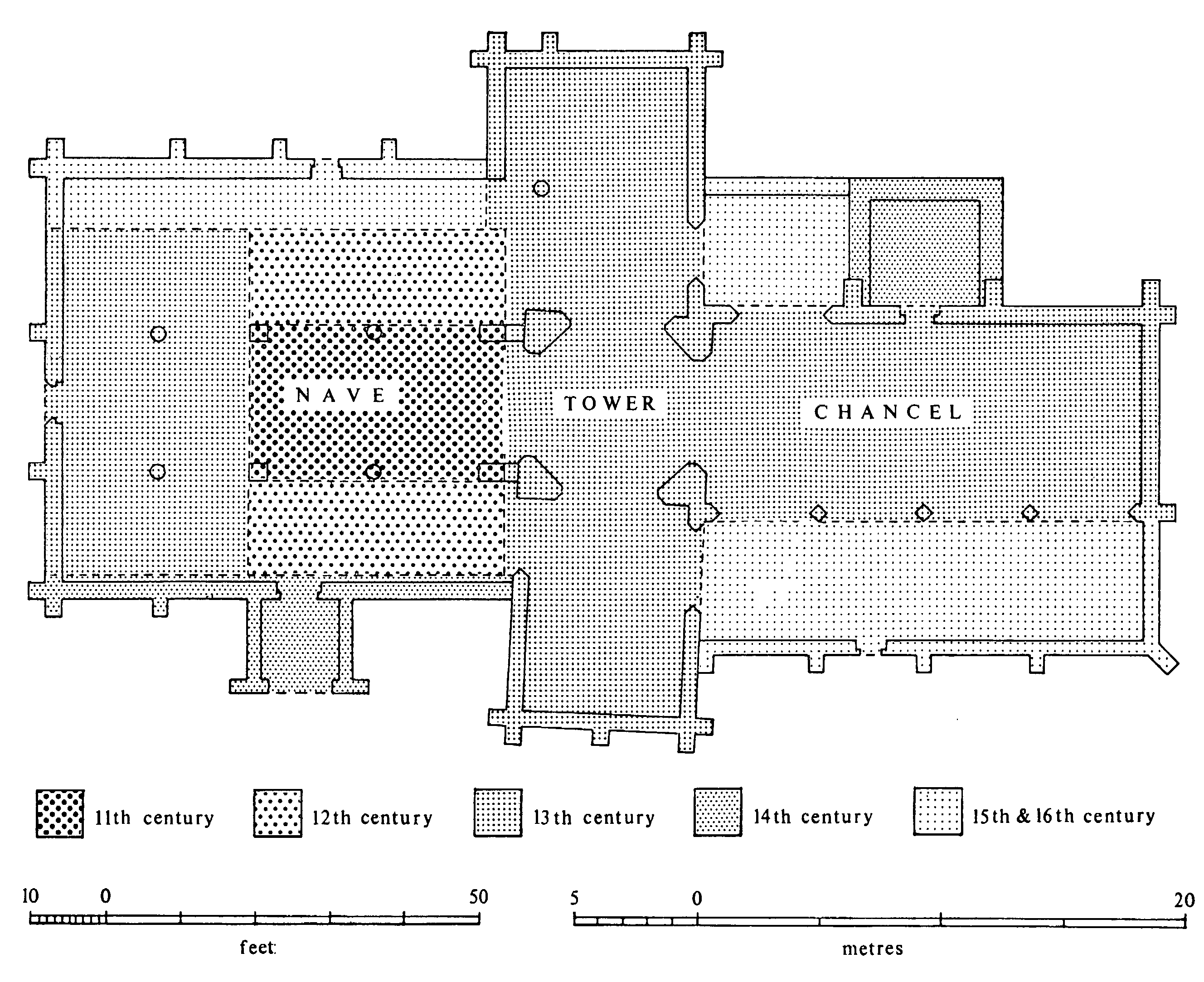
The church of St. Mary: Block Plan
There was one service each Sunday in 1743 and 1764, and communion was received four times a year by about 100 people. (fn. 159) By 1851 there were two weekly services, (fn. 160) and in 1865 and later communion was celebrated monthly with about 20 communicants. (fn. 161) By 1914 communion was celebrated weekly. (fn. 162) There were three services each Sunday in 1973. A mission room was erected at Cliffe in 1908 and a weekly service and monthly communion were held there in 1914; (fn. 163) a service was still held there each Sunday in 1973.
The church of ST. MARY, mostly of limestone, has a chancel with north vestry and north and south chapels, a central tower with spire and transepts, and an aisled and clerestoried nave with south porch. (fn. 164)
The two eastern bays of both nave arcades are of the late 12th century but have been cut through the walls of an earlier building, of which all four corners can still be seen, which probably dates from the 11th century. Soon after 1200 the nave and aisles were extended westwards by two bays and a north transept, with a narrow aisle on its west side, was added. The latter suggests that the church was being enlarged to a cruciform plan which would involve an extensive reconstruction of the east end, but no evidence of this remains. The work may not have been completed, or there may have been some calamity like the fall of the crossing tower, for the south transept is of the late 13th century and the present crossing tower is only slightly later and is contemporary with an extensive reconstruction of the north transept and the building of the chancel. The lower storey of the vestry was built in the mid 14th century at about the time that the south aisle was widened and the south porch added. In 1410 £10 was bequeathed for the rebuilding of the 'north part' of the church; (fn. 165) possibly this was the north aisle but if so nothing survives as evidence that the work was done.
By 1426 the church was therefore already fairly large. It is not certain how much of the £171 said to have been spent by John of Wessington (prior 1416- 46) on making it collegiate (fn. 166) was used for the domestic buildings, and how much for alterations about the church. The topmost part of the tower has Wessington's rebus and the spire is probably of his time. Collegiate use would also have made some refitting of the east end necessary but there is no longer any evidence of this. Several new windows were put in during the 15th century, the largest being at the west end of the nave and in the end walls of the transepts. The insertion of the new window in the south transept was part of a reconstruction that involved raising the roof and putting in a clerestory of three bays, the central one of which on each side being reused. The date of the nave clerestory may be nearer to 1500 and it appears to be contemporary with the north aisle. (fn. 167)
The transepts were used as chapels from an early date, and the original piscina and backing for a reredos remain in the south transept. The Babthorpe chantry chapel, between the north transept and the vestry, was probably built soon after the deaths of Thomas Babthorpe's father and brother in 1455 (fn. 168) and the room over the vestry is contemporary with it. The south chapel, which is joined to the chancel by an arcade of four bays, was probably built at the expense of Anne Manners of Turnham Hall after 1513 (fn. 169) and was used as a Lady chapel.
Many of the medieval fittings, including the rood screen and much stained glass, have gone, but among those that remain are the font of c. 1200, a single misericord of c. 1300, parts of stalls and much restored seating of the early 16th century, and the screens to the south chapel.
A gallery was put up and the pulpit was moved to beneath the south aisle in 1717. (fn. 170) During the following century box pews, using much of the timber of the old seating, were erected throughout the nave. The fabric was in frequent need of repair in the 18th century, but the major restorations of the nave and transepts were carried out between 1851 and 1858, apparently in part by J. L. Pearson, (fn. 171) of the chancel in 1882-3, directed by Ewan Christian, (fn. 172) and of the south chapel in 1884. (fn. 173)
There were four bells in 1552. (fn. 174) Five new bells were made by E. Seller of York in 1730, (fn. 175) and to those a sixth was added in 1907. (fn. 176) The plate includes a silver cup, made in 1617 by Francis Tempest of York, and two flagons and a pewter plate; one of the flagons is inscribed with the donor's name, John Allison of Lund, and the date 1719. (fn. 177) The registers begin in 1605 but have a gap between 1638 and 1653. (fn. 178)
Additions to the churchyard were consecrated in 1872 (fn. 179) and 1915. (fn. 180)
NONCONFORMITY.
Many recusants and noncommunicants were reported in the parish in the later 16th and 17th centuries, the number sometimes reaching 50 or 60. (fn. 181) There was one Roman Catholic family in Hemingbrough in 1764. (fn. 182)
Two families of Presbyterians and one of Quakers were reported in the parish in 1743 and one family of unspecified dissenters in 1764. (fn. 183) Houses in Hemingbrough township were registered for dissenting worship in 1787 and 1812. (fn. 184) A chapel was built there by the Wesleyan Methodists in 1836 and rebuilt in 1848, (fn. 185) and it was still used for worship in 1973. The Primitive Methodists replaced an earlier meeting-place (fn. 186) by a chapel built in 1857. (fn. 187) Its registration was cancelled in 1937 (fn. 188) and it was used as a storehouse in 1973.
Methodists were numerous in the township and were said in 1865 to comprise about two-thirds of the population; in 1914 the vicar described them as strong but friendly and stated that most of them used the parish church for baptism, burial, and marriage. (fn. 189) A. J. Kelsey, by will proved in 1930, bequeathed £200 to be invested for the use of the Wesleyan Sunday school. (fn. 190)
EDUCATION.
There are half-a-dozen instances of masters being licensed to teach a grammar school at Hemingbrough between 1619 and 1807, (fn. 191) but no more is known of the school. It may have been held in the church, where the chapel on the south side of the chancel was described as a schoolroom in 1750. (fn. 192) A petty school master was licensed in 1794; (fn. 193) he had also been mentioned in 1786. (fn. 194)
In 1835 there was reported to be a school at Hemingbrough, attended by 35 children and endowed with land worth £4 a year to teach 4 pupils free. (fn. 195) The endowment was also mentioned in 1823, when it was described as a 2-acre close in Barlby, (fn. 196) and it was presumably the land devised by Ralph Lodge, by will proved in 1661, for the education of poor children in Hemingbrough and Barlby. (fn. 197) The first known school-house is that built by Mary Carr on the corner of Finkle Street and the back lane in 1847. (fn. 198) There were said to be 70 children at a school in the township in 1868 (fn. 199) and 24 children attending a school in 1871, but at the latter date there were two other schools for which details were not available. (fn. 200)
A school board was formed in 1875 (fn. 201) and a school was built on the Howden road in 1877 and opened in January 1878. (fn. 202) Its initial income was about £55 from school pence and the average attendance in 1878 was 65 boys and girls and 20 infants. (fn. 203) An annual government grant, however, began to be received that year. (fn. 204) Mary Carr's schoolroom was subsequently used as a reading room (fn. 205) and in 1922 was acquired for a village institute. (fn. 206) It still stood in 1973, a small rectangular building of brick with stone dressings, wide overhanging eaves, and pointed wooden tracery in the windows. The charity close in Barlby was sold in 1896 and the proceeds invested in £72 stock; the income was used for payments to school children in accordance with a Scheme of 1880. (fn. 207)
The average attendance at the board school in 1903 was 69. (fn. 208) The school was enlarged by the county council in 1906-7 and its spire was removed in 1927. (fn. 209) In 1908-12 the average attendance was about 100 and in 1913-38 about 80-90. (fn. 210) Senior pupils were transferred to Barlby secondary school in 1960. (fn. 211) A new school at Hemingbrough, built on the same site, was opened in 1962, though part of the old building was retained. (fn. 212) There were 119 pupils on the roll in September 1973. (fn. 213) The charity income in 1973 was nearly £2, but no payments had been made for some years. (fn. 214)
CHARITIES FOR THE POOR.
William Widdowes or Widhouse, by deed of 1624, gave a 5-acre close, the rent to be distributed to the poor at Hemingbrough. Before 1770 two unknown donors gave £1 a year and 10s. a year respectively from closes in the township. W. Sharrow, before 1770, left 7s. a year out of Barmby Sieve carr. All four gifts were reported to be distributed to the poor in 1823. (fn. 215) Known as the United Charities, they were regulated by a Scheme of 1918, when the endowments consisted of 5 a., rent-charges of £1 17s., and £22 stock. In 1972 the income was £18 and payments of over £1 were made to each of fifteen people. (fn. 216)
John Allanson or Allison, by will dated 1722, gave £2 from a house and land in Lund, to be distributed in bread to the poor of the parish. Joseph Underwood, in 1781, gave 12s. a year from 2 a. in Hemingbrough to be laid out in bread. These two bequests were used in 1823 to distribute weekly bread worth 1s. (fn. 217) Part of the rent-charge was being withheld in the early 20th century (fn. 218) and no more is known of the charity.
Thomas Steele, by will dated 1777 and codicil dated 1787, made a bequest to provide a threepenny loaf weekly for each of twelve poor women of the parish, as well as a guinea for the vicar for a sermon and 2s. 6d. for the parish clerk; any surplus income was to go to the church organist. (fn. 219) In 1816 it was decided to give the bread to 3 women in Hemingbrough, 3 in Cliffe with Lund, 2 in South Duffield, 2 in Menthorpe, Bowthorpe, Brackenholme, and Woodhall, one in Barlby, and one in Osgodby. (fn. 220) The income in 1972 was £9 from £300 stock; bread was given each week to one person and £4 was used for church purposes. (fn. 221)
William Pickup, by will proved in 1931, bequeathed £100 for the benefit of twelve widows in the township. In 1972 £100 stock produced over £3 income, distributed to twelve persons. (fn. 222)