A History of the County of York East Riding: Volume 3, Ouse and Derwent Wapentake, and Part of Harthill Wapentake. Originally published by Victoria County History, London, 1976.
This free content was digitised by double rekeying. All rights reserved.
A P Baggs, G H R Kent, J D Purdy, 'Skipwith', in A History of the County of York East Riding: Volume 3, Ouse and Derwent Wapentake, and Part of Harthill Wapentake, ed. K J Allison (London, 1976), British History Online https://www.british-history.ac.uk/vch/yorks/east/vol3/pp89-101 [accessed 30 April 2025].
A P Baggs, G H R Kent, J D Purdy, 'Skipwith', in A History of the County of York East Riding: Volume 3, Ouse and Derwent Wapentake, and Part of Harthill Wapentake. Edited by K J Allison (London, 1976), British History Online, accessed April 30, 2025, https://www.british-history.ac.uk/vch/yorks/east/vol3/pp89-101.
A P Baggs, G H R Kent, J D Purdy. "Skipwith". A History of the County of York East Riding: Volume 3, Ouse and Derwent Wapentake, and Part of Harthill Wapentake. Ed. K J Allison (London, 1976), British History Online. Web. 30 April 2025. https://www.british-history.ac.uk/vch/yorks/east/vol3/pp89-101.
In this section
SKIPWITH
The Large parish of Skipwith, including the township of North Duffield, lies about 9 miles south-east of York and stretches westwards from the river Derwent for 5 miles into the heart of the wapentake. (fn. 1) Part of the hamlet of Menthorpe, beside the Derwent, was also in the parish, the rest lying in Hemingbrough. The Anglian settlement of Skipwith, the 'sheep farm', (fn. 2) had extensive pastures, and the small village is still half surrounded by over 800 a. of common heath and woodland. The much larger village of North Duffield, also Anglian, which enjoyed a late-surviving market and fair, lies near the main road from Selby to Market Weighton and its ancient crossing place over the Derwent. The parish comprised 6,258 a., of which 3,417 a. were in North Duffield and 197 a. in Menthorpe. (fn. 3) The civil parish of North Duffield was enlarged in 1935 by the addition of Menthorpe with Bowthorpe civil parish. (fn. 4)
The whole parish is flat and low-lying without any prominent relief features. Much of it lies at more than 25 ft. above sea-level, but north-west of Skipwith village and south and east of North Duffield village large areas are lower still. Most of Skipwith township and much of North Duffield are composed of outwash sand and clay, with some alluvium beside the Derwent. (fn. 5) The small open fields of Skipwith, which were not inclosed until 1904, lay largely above 25 ft., but those of North Duffield, inclosed in 1814, (fn. 6) stretched far into the lower ground. There were extensive areas of old-inclosed assarts in both townships. Carrs and ings lay beside the Derwent, and the surviving common land in Skipwith continued into North Duffield until inclosure in 1814.

SKIPWITH 1769
Numerous dikes and streams drain into the Derwent or westwards towards the river Ouse. The entire northern boundary of Skipwith township is formed by a stream which becomes Dam dike in Riccall, further west, and another forms the northern boundary of North Duffield. The chief stream in Skipwith rises on the common and, as Holmes dike, joins Dam dike at the Riccall boundary. On the south the boundary with Cliffe and South Duffield formerly divided the commons and woodlands of Skipwith from those called Blackwood; (fn. 7) in 1280 Anvers, Burdun, and Moreby pits marked the boundary line. (fn. 8) The entire eastern parish boundary follows the Derwent. The riverside land has always been liable to flooding despite the maintenance of flood banks, described in 1760 as 'a rampart to defend the water out of the carrs, ings, etc.'. (fn. 9) In Skipwith the northern boundary stream flooded part of the township in the 14th century. (fn. 10)
Skipwith common or moor, including an area known as Crook moor, still covers 857 a. (fn. 11) Robert Aske ordered rebels to assemble there in 1536, during the Pilgrimage of Grace. (fn. 12) The common belonged to Skipwith manor and was sometimes called Lord's or Hall moor. (fn. 13) In part it consists of dry heathland, but there are many ponds and swampy places as well as extensive woods. The socalled Line ponds, near the village, (fn. 14) may have been used for flax-dressing. Three small plantations near the road across the common to Selby were said to have been established by J. P. Toulson (fn. 15) in the early 19th century, but much of the woodland is natural. There are many barrows, known as Danes' Hills, especially in the north and west of the common. When the open fields were inclosed in 1904 the common was left alone, but for its betterment a board of five conservators was established, one each to be appointed by the lord of the manor, the rural district council, and the parish meeting, and two by the commoners. (fn. 16) By-laws were subsequently made by the conservators. (fn. 17) The wartime airfield at Riccall extended into the common, (fn. 18) but a large area was in 1954 designated as a site of special scientific interest on account of the varied plant and animal life there and about 600 a. have been administered as a nature reserve since 1968. (fn. 19)
Skipwith village stands beside roads leading to Escrick and North Duffield which form part of the York-Howden road. Minor roads lead to Thorganby and Cliffe, but others running towards Selby and Riccall are in part only unsurfaced trackways on the common, and the Riccall road was blocked by the construction of Riccall airfield. From North Duffield village a minor road leads to Menthorpe and Hemingbrough, and others formerly led to South Duffield and Thorganby. The chief road in North Duffield, however, is that which now runs straight across the township, skirting the south end of the village, and forms part of the Selby to Market Weighton road. Until the late 18th century the road followed a circuitous course through the village. (fn. 20) It was turnpiked in 1793 and new sections were built to bypass the village and lead directly to the Derwent crossing; the old course from the Menthorpe road to the river has been lost. Several of the milestones erected by the trust still stand. The trust was discontinued in 1879. (fn. 21) The river crossing was also improved in 1793 by the building of a bridge to replace a ferry which had existed since at least the 13th century. (fn. 22) The bridge was owned not by the turnpike trust but by an independent company, and tolls continued to be collected at a house on the Duffield side of the river (fn. 23) until the bridge and toll rights were bought by the East Riding county council in 1936. (fn. 24) The stone bridge is of three arches with big round cutwaters, and the road approaches it on a causeway supported by seven brick arches.
The railway line from Selby to Market Weighton, opened in 1848, (fn. 25) crossed the south-east corner of North Duffield township, with a bridge over the Derwent; it was closed in 1965. (fn. 26) The line has been lifted but the bridge remains. The Derwent Valley Light Railway, opened in 1912, also crossed North Duffield, with a station near the boundary with Skipwith. It was closed for passengers in 1926 (fn. 27) and goods in 1965; (fn. 28) the line has been lifted but the station remained in 1973.
Some of the houses of Skipwith village stand around the junction of the Escrick, North Duffield, Cliffe, and Selby roads, but most of them date only from the 19th and 20th centuries. In 1769 almost all the village houses were spread out along a road running westwards from that junction which eventually peters out as field and farm roads. This is still the main village street, and despite some recent infilling it remains only loosely built up. The church stands near one end of it. Apart from the hall and the Vicarage (fn. 29) there are few noteworthy houses; Red House Farm was built in 1908 by Lord Wenlock, (fn. 30) and there are sixteen council houses and bungalows. Beyond the village a few houses are known as Little Skipwith, and the road widens out into Scarrow Green before the farm roads begin. There are village ponds at the east end of the main street and at Scarrow Green. There were three licensed houses at Skipwith in the 1750s, only two later in the century. (fn. 31) The Hare and Hounds existed by 1822, (fn. 32) and by 1872 there was a second public house, the Drovers' Inn. (fn. 33) Both remained in 1973. A village institute was built in 1923. (fn. 34)
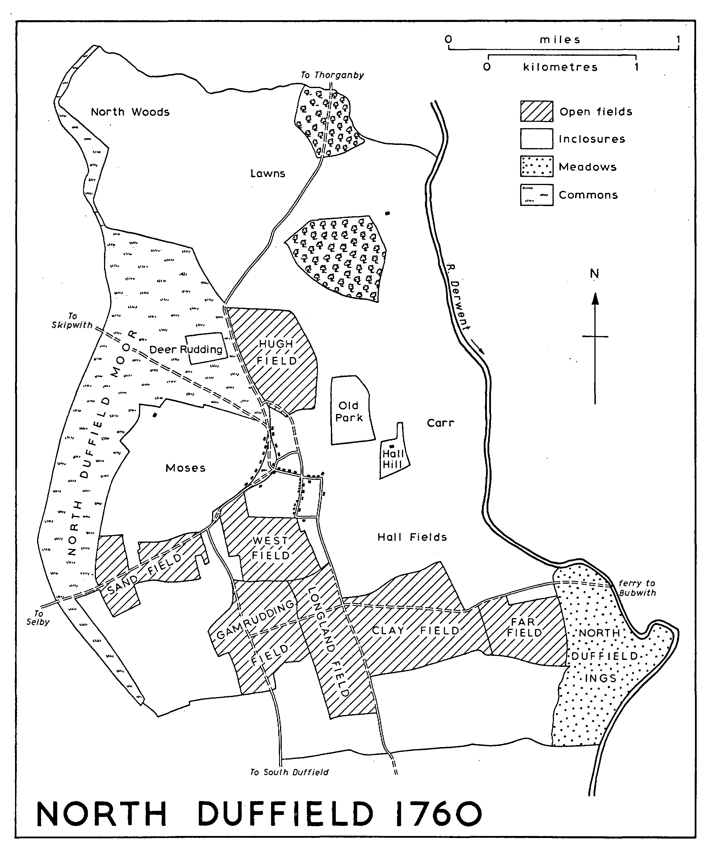
NORTH DUFFIELD 1760
North Duffield is a large village, perhaps reflecting the success of the market and fair granted in the 13th century. (fn. 35) The closely built up main street is linked to a large green, partly surrounded by widely spaced houses. The green, with its pond, may have been laid out as a market-place and fair ground. It was reduced in size in 1814 by the inclosure of about 4 a. at the northern end. The main street is joined at both ends to a back lane, and a footpath called Priest Lane also runs between them. The village houses, dating from the 18th century onwards, include several 19th-century farm-houses, among them the Tudor-style Gothic Farm. In the 20th century several bungalows have been inserted around the green, a 'close' of private houses has been laid out off the main street, and 22 council houses and bungalows have been built, a dozen of them in the back lane. A village hall was opened in 1938. (fn. 36) Part of the pinfold wall stands by the roadside on the green.
There were two licensed houses at North Duffield in the 1750s but only one in the later 18th century. (fn. 37) The King's Arms and the Cart and Horses were in existence by 1822. (fn. 38) The former, near the green, still exists but the Cart and Horses, in the main street, closed c. 1950. (fn. 39)
By 1769 there were at least three outlying farmhouses in Skipwith, as well as the miller's house; (fn. 40) the farms were those known in 1973 as Bridge, Grange, and Peel Hall Farms, the last name deriving from Pithhill close, which adjoined the house in 1769. Another outlying house, in Hackings closes, mentioned in 1727 (fn. 41) had apparently been demolished by 1760. The house later called Charity Farm seems to have existed by 1772, perhaps even by 1711 when the farm was sold together with its house. (fn. 42) Outlying buildings at North Duffield in 1760 were the miller's house, the hall, (fn. 43) and farmhouses now called North Duffield Lodge and Blackwood House. (fn. 44) A terrace of cottages called New Houses stands beside the road built to bypass the village, and Blackwood Hall was put up in the mid 19th century. (fn. 45) At Park House the farm buildings include a wheelhouse. The remains of a small motte, called Giant Hill, stand by the river opposite Aughton village.
There were 32 poll-tax payers at Skipwith in 1377, said to be 'of the geldable'; (fn. 46) the bishop of Durham's fee was presumably excluded and there is no return for North Duffield. In 1379 there were 48 poll-tax payers at Skipwith and 136 at North Duffield. (fn. 47) There were 48 households at Skipwith in 1672, 7 of them exempt from the hearth tax; of those that were charged 29 had one hearth each, 7 had 2, 4 had 3 or 4, and one had seven. At North Duffield there were 59 households, 4 of them exempt; 43 had one hearth, 7 had 2, 4 had 3 or 4, and one had six. (fn. 48) There were 90 families in the parish in 1743 and 85 in 1764. (fn. 49)
The population of Skipwith was 247 in 1801. It reached 315 in 1821 but fell to 239 in 1901. The greatest number in the 20th century was 255 in 1911 and it stood at 202 in 1971. (fn. 50) North Duffield had 313 inhabitants in 1801. The number varied from 433 in 1821 to 344 in 1831, 470 in 1861, and 309 in 1901. It recovered to 349 in 1921 but fell to 317 in 1931, and even with Menthorpe and Bowthorpe included it was only 341 in 1971. (fn. 51)
MANORS AND OTHER ESTATES.
In 1086 Skipwith consisted of 3 carucates belonging to Hugh son of Baldric, which before the Conquest had been held by Gam. (fn. 52) The bishop of Durham subsequently acquired 2 carucates there and in 1200 enfeoffed Richard d'Avranches of them. (fn. 53) The d'Avranches family held the estate until at least 1353, (fn. 54) but by 1400-1 it had passed to the Skipwith family, by the marriage of Catherine d'Avranches and William Skipwith. (fn. 55)
After 1086 a carucate in Skipwith passed to Robert de Stutville. (fn. 56) The overlordship descended to the Wakes by the marriage in or before 1229 of Joan de Stutville and Hugh Wake, and in 1325 Margaret Wake married Edmund, earl of Kent. (fn. 57) The heirs of the earl of Kent were recorded as overlords as late as 1418. (fn. 58) By 1166 Robert Murdac had succeeded Richard Murdac as tenant in demesne under the Stutvilles. (fn. 59) The estate subsequently passed to a family known alternatively as Thorpe or Skipwith. (fn. 60) They are first mentioned in the early 13th century, when Osbert of Skipwith had an interest there. (fn. 61) The name Skipwith prevailed, and in 1418 Sir Thomas Skipwith died seised of the whole manor of SKIPWITH, two-thirds held of the Durham fee and one-third of the Wake fee. (fn. 62)
The manor was held by the Skipwiths (fn. 63) until 1709, when Mary, widow of Willoughby Skipwith, sold it to Francis Annesley; besides rents it comprised only a farm of 63 a. Francis, the Revd. Francis, and Arthur Annesley sold it in 1801 to Thomas Bradford (fn. 64) and he the following year to J. P. Toulson. (fn. 65) Thus it was that Toulson was described as lord of the manor in 1802, (fn. 66) before he became entitled to the rest of the old manorial estate.
At least part of the manor was let by the Skipwiths to the Herberts, for in 1609 Rowland Herbert devised his lease of 'the demesnes' to his son Gilbert. (fn. 67) Elizabeth, widow of Richard Herbert (d. c. 1700), married George Toulson, (fn. 68) and it was to Toulson and his heirs that Richard Herbert's son Robert devised the manor-house and demesnes in 1706; they were said to be held on an 800-year lease. (fn. 69)
On the death of another George Toulson in 1766 the estate passed to his daughter Jane and her husband Banastre Walton (d. 1781). (fn. 70) Jane next married, in 1799, Robert Hudson and the manor was then settled successively on Hudson (d. 1808), Jane (d. 1819), (fn. 71) Jane's cousin John Parker, who had taken the surname Toulson (d. 1824), (fn. 72) and Toulson's son J. A. P. Toulson. (fn. 73) The Hudsons, as owners of the estate, lived at the hall but J. P. Toulson also lived in the parish and was, as has been seen, lord of the manor as early as 1802. (fn. 74) By 1827 J. A. P. Toulson was in possession, (fn. 75) and in 1840 his estate in Skip with included 1,958 a. (fn. 76) After his death in 1889 (fn. 77) his trustees sold the manor, with 1,864 a., to Lord Wenlock in 1898. (fn. 78) At inclosure in 1904 Wenlock was allotted 271 a. for open-field land and common rights. (fn. 79) The manor subsequently descended like Escrick, (fn. 80) and in 1972 the Forbes Adam family still had 2,511 a. in Skipwith. (fn. 81)
Before the acquisition of the manor the Wenlocks already had an estate in Skipwith, established by their predecessors the Thompsons. In 1789 Jane Walton settled some of the manorial lands upon her cousin John Parker. (fn. 82) She and her husband Robert Hudson nevertheless sold most of the property involved to Joseph Buckle in 1800. (fn. 83) The sale was disputed by Parker, who had in the mean time taken the name Toulson, and by an agreement of 1801 he was to receive the purchase money from Buckle. (fn. 84) The land was conveyed by the Buckles to Richard Thompson in 1819. (fn. 85) Thompson had already bought about 50 a. in the township in 1813, (fn. 86) and the Thompsons had 550 a. there c. 1857. (fn. 87)
The Skipwith family's manor-house probably stood on a large moated site which still existed, opposite the church, in 1973. It was presumably there that William Skipwith was allowed to have a portable altar in 1454. (fn. 88) The house appears to have survived until the 17th century, but in 1657 the manor-house or hall was described as 'prostrated and demolished'. (fn. 89) A cottage called Moat Hall stood there into the 20th century. (fn. 90) The site of the present house may have been occupied by the later 17th century. Richard Herbert had a house with seven hearths in 1672, (fn. 91) and a manor-house or hall-house was mentioned from at least 1705 onwards. (fn. 92) The service wing, in which there is a late-17th-century staircase, may have been part of this building. The main block of the house, facing south, appears to be of c. 1725 and is a plain three-storeyed building of red brick which retains its original staircase and some panelling and fire-places. Two-storeyed wings were added early in the 20th century, and there was some refitting at the time when the Forbes Adam family moved to Skipwith from Escrick. (fn. 93) One wall in the large walled gardens contains heating flues.
An estate of 7 carucates and 2 bovates at North Duffield belonged after the Conquest to William Malet, but he was disseised of it in 1069 and by 1086 it was held by Niel Fossard under the count of Mortain. (fn. 94) The soke of 2 bovates belonged to Howden. (fn. 95) Rival claims to Malet's possessions may explain disputes over the ownership of the estate in the 12th and early 13th centuries. It is said to have been acquired after 1086 by the bishop of Durham, (fn. 96) but it was also claimed by the Percys. As late as 1320, on the death of the demesne lord, it was first said to be held of Henry de Percy but in a later inquisition of the bishop of Durham, (fn. 97) and the bishop's overlordship was recorded as late as 1441. (fn. 98)
Under the Percys the estate was held by the Chamberlains, but in 1196 John Chamberlain was in dispute with Ralph Bardolf, (fn. 99) and in 1210 Robert Chamberlain upheld his claim against Roger Bardolf. (fn. 100) In the 1220s Robert was in dispute over North Duffield with the Mauleys, who claimed it by inheritance from the Fossards. (fn. 101) In 1251 Henry Chamberlain granted NORTH DUFFIELD manor to Roger of Thurkelby (d. 1260), (fn. 102) but the Chamberlains retained a mesne lordship under the bishops of Durham. (fn. 103) By 1280 the manor belonged to Robert Salvain, who claimed it as the inheritance of his wife Sibyl, niece of Roger of Thurkelby. (fn. 104) It was held by the Salvains (fn. 105) until 1486, when it was granted to John Hussey and Thomas Ballard during the minority of Anne, daughter and heir of Sir John Salvain. (fn. 106) By 1496 Anne was the wife of Sir William Hussey (d. 1530), (fn. 107) in whose family the manor subsequently descended. After William Hussey died seised of it in 1570 it passed to his brother John and then to John's daughter Anne, who married Sir Robert Constable. (fn. 108) In 1614 William Constable sold it to William Ingleby and others, and in 1624 they conveyed it to Peter Middleton. (fn. 109) Peter's son William held it in 1634, (fn. 110) and it belonged to John Middleton in 1673 (fn. 111) and William Middleton in the late 18th century. (fn. 112)
In 1808 William and Peter Middleton sold the manor, with about 2,240 a., to John and William Scholfield, James Lister, and Robert Spofforth, the younger. (fn. 113) At inclosure in 1814 707 a. were allotted jointly to William Scholfield, Spofforth, and Lister. (fn. 114) Spofforth gave up his share to the others in 1823, (fn. 115) and in 1841 the estate was assigned by Scholfield and Lister to Robert Scholfield. (fn. 116) About 900 a. were sold soon after to Thomas Dunnington. (fn. 117) After Robert Scholfield's death in 1868 the rest of the estate passed successively to Edward Scholfield (d. 1869), to Robert's son R. S. Scholfield (d. 1913), and to E. P. Scholfield. (fn. 118) Most of it, some 1,350 a., was sold in separate lots in 1920-1, (fn. 119) and in 1922 the manor, with 29 a., was sold to C. H. (later Sir Charles) Wilson (d. 1930). (fn. 120)
The medieval manor-house of the Salvains, mentioned in 1320, (fn. 121) presumably stood on the site now occupied by a farm-house known as North Duffield Hall, which still has prominent earthworks around it. This is traditionally the site of a 'castle', (fn. 122) presumably the fortified manor-house.
The land bought by Thomas Dunnington in 1841 (fn. 123) subsequently formed Lawns House, Lodge, and Redmoor House farms, and part of West Lodge farm in Thorganby. It was held by the Dunningtons and Dunnington-Jeffersons until 1953 and 1964, when 910 a. were sold in separate lots by Sir John Dunnington-Jefferson, Bt. (fn. 124)
That part of Menthorpe lying in Skipwith parish belonged, like Skipwith manor, to the Stutville fee. Some of the land was held by the Skipwith family in the Middle Ages. (fn. 125) The manor of MENTHORPE is said to have been sold by John Skipwith (d. 1680) about 1670 to Faith, widow of Robert Woodburne, vicar of Skipwith. (fn. 126) After the death of James Woodburne in 1717 the manor was sold by his trustees in the 1720s to the Robinson family. Richard Robinson, who married Anne Sandys, devised undivided shares in the manor to his five daughters, one of whom married Edwin Sandys Bain. (fn. 127) In 1838 and 1841 Bain acquired the other shares, (fn. 128) and in 1872 he conveyed the estate, comprising 197 a., to his daughter Frances and her husband E. W. Sandys. (fn. 129) Known as Hall farm, it was sold by W. B. R. Sandys to A. H. Blakey in 1919, and by T. O. Blakey to the Flint Co. Ltd. in 1969. (fn. 130)
Other land in the Stutville fee belonged in the 13th century to the Eyville family, apparently having been acquired by Emery d'Eyville from Walter of Bubwith in 1284. (fn. 131) It was conveyed by John d'Eyville to Thomas Dawnay in 1372, (fn. 132) and by Sir John Dawnay to Thomas Watkinson in 1572. (fn. 133) The Watkinsons also acquired land in Menthorpe from Marmaduke Fawkes in 1573 (fn. 134) and William Babthorpe in 1619. (fn. 135) They sold the estate in 1668 to Christopher Adams, whose family retained it until the death of John Adams in 1791. It then passed to John's sister Frances, wife of Jocelyn Price, and at her death in 1816 she was succeeded by her daughters Lucy, who married a Capt. Willye, and Clara, who married Sir Charles Blois. (fn. 136) Clara and her husband granted their share of the estate, which comprised altogether 130 a., to Lucy's son Jocelyn in 1840. (fn. 137) Jocelyn Willye died in 1863 and the estate passed for life to his widow Frances (née Carus Wilson) (d. 1872). (fn. 138) It was sold to Martin Willans in 1874, then consisting of a house and 145 a., (fn. 139) and after his death in 1887 it was held by trustees until sold in 1969 to the Flint Co. Ltd. (fn. 140)
In 1086 an estate of a carucate in North Duffield belonged to Gilbert Tison, (fn. 141) but before 1100 he confirmed the gift of it to Selby abbey (Yorks. W.R.) by his man Swane. (fn. 142) Some small additional gifts were made to the abbey in the 13th century. (fn. 143) Under the abbot as overlord the carucate of land was held by Gerard Salvain in 1320. (fn. 144) Some of the land of the Selby fee may have belonged to freeholders; in 1286 freeholders with at least 18 bovates did homage to the Salvains. (fn. 145) The descent of these holdings has not been traced.
Lands in Skipwith described as late of Gisborough priory were granted to Christopher Estofte and Thomas Doweman in 1553, when they were in the tenure of Rowland Herbert. (fn. 146) A hermitage at North Duffield belonging to the Knights Hospitallers was recorded between the 1190s and c. 1280. (fn. 147)
From 1279 the rectory of Skipwith belonged to Skipwith prebend in Howden college. (fn. 148) It was worth £33 6s. 8d. in 1291. (fn. 149) In 1535 the tithes produced £18, of which £10 13s. 4d. was from North Duffield, £5 6s. 8d. from Skipwith, and £2 from Menthorpe; the net value to the prebend was £13 6s. 8d. all told. (fn. 150) After the dissolution of the college the tithes were let by the Crown in 1568 to Thomas Mytton and others. (fn. 151) In 1594, when Nicholas Thompson was farmer of the rectory, it was found that the parsonage house, described as a 'cross house', had been demolished about sixteen years earlier. (fn. 152) Rowland Herbert devised a Crown lease of the tithes to his son Gilbert in 1609. (fn. 153) In the latter year the tithes were granted in fee to Francis Morrice and Francis Philips, (fn. 154) who conveyed them the same year to Gilbert Herbert. (fn. 155) In 1628 Philip Herbert conveyed the tithes of Skipwith to John Herbert and in 1629 those of North Duffield to Robert Marshall. (fn. 156) The value in 1650 was £80 to Rowland Herbert, £40 to Michael Marshall, and £13 to Thomas Watkinson, (fn. 157) the last-named enjoying the tithes of Menthorpe. (fn. 158)
Elizabeth Shilleto and Anne Marshall conveyed their tithes in Skipwith to George Toulson in 1747, (fn. 159) and they subsequently descended with Skipwith manor. In 1840 they were commuted for £113 payable to J. A. P. Toulson and 15s. to Matthew Kirk. (fn. 160)
The tithes of North Duffield were conveyed by John Herbert and others to Nathaniel Wilson and others in 1707. (fn. 161) Richard Wilson sold them in 1777 to John Raper and others, and they to Robert Spofforth, the elder, in 1796. (fn. 162) At inclosure in 1814 348 a. were awarded to Spofforth in lieu of tithes, (fn. 163) and this land subsequently formed part of Park farm and the Blackwood estate. Park farm, comprising 193 a., was sold by Samuel Spofforth to Charles Weddall in 1828, (fn. 164) and the Weddalls held it until 1918, when it was sold to the Bramley family. (fn. 165) The nucleus of the Blackwood estate, comprising the house and 56 a. of closes, was acquired by Spofforth in 1807 (fn. 166) and to this most of the tithe allotment was added. The 382-acre Blackwood House farm was bought from Spofforth's trustees in 1835 by T. S. Benson and Sharon Turner in trust for the daughters and grandson of Henry Roxby (d. 1828). (fn. 167) Blackwood Hall was later built there by T. M. Roxby, who in 1868 mortgaged the estate to the Law Life Assurance Society. (fn. 168) The society's trustees sold the property to Annie and Eleanor Newsome in 1893, (fn. 169) and the Newsomes retained it until it was sold in separate lots in 1963 and 1967; the hall passed to Blackwood Hall Farms Ltd. (fn. 170)
The tithes of Menthorpe were evidently sold with the Watkinsons' land in the township to Christopher Adams in 1668 and subsequently descended with it. The Adams family were certainly the improprietors in the later 18th century. (fn. 171) When the tithes were commuted in 1839 rent-charges totalling £66 were allotted jointly to Sir Charles Blois and Lucy Willye. (fn. 172)
ECONOMIC HISTORY.
At Skipwith in 1086 there was land for two ploughs, but Hugh son of Baldric had one plough and twelve villeins had three. There was woodland two leagues long and one broad. The estate had decreased in value from £2 before the Conquest to £1 in 1086. (fn. 173) Medieval assarting, though there is little record of it, produced a large area of early inclosed farm-land, as well no doubt as additions to the open field nucleus. Woodland and moor remained prominent, however, and were mentioned in the 13th and 14th centuries, when the Skipwith and d'Avranches families had shares in them. (fn. 174) In 1310 the 'parson' of Skipwith (either the prebendary or the vicar) surrendered to Richard d'Avranches his right to have wood, pasture, and turf in Skipwith wood, and in return was granted 5 a. of wood for his own use, common of pasture wherever Richard's free tenants had it, and fifteen loads of turf a year. (fn. 175) The value of wood, mostly taken from an area called Mapple wood, contributed £9 to the £53 at which Sir William Skipwith's manor was valued in 1536. (fn. 176)
The results of earlier assarting are to be seen in the names of numerous closes recorded in the early 17th century, several of them incorporating 'hurst' and 'ridding'. (fn. 177) By that time there was open-field land in Out, Inholme, West, South, and North fields, and in North Tofts, Southmoors, and Harthowrey. (fn. 178) South Ridding was also apparently held in strips, (fn. 179) though in 1769 it was a close adjoining South field and the common. (fn. 180) There was also common meadow land in the ings and pasture in the Holmes. (fn. 181) The villagers enjoyed rights on the common in the 17th century, taking pasture, turves, and whins; one man's rights, in 1642, were for 6 cattle, one horse, 80 sheep, 2 swine, ducks, and geese. (fn. 182)
The same areas of open-field land were all recorded in the earlier 18th century, though by 1769 Out and Inholme fields had been either inclosed or incorporated in the other fields. Most of the closes beyond the open fields were small and many were irregularly shaped, reflecting the process of early assarting; but in 1709 closes called Hughthwaite Carrs and the Wrays contained 30 a. and 50 a. respectively, though both had been subdivided by 1769. (fn. 183) An area of woodland belonging to the manor remained, north-west of the village, in 1769, and in 1776 Charity farm included Hollingwood, Holliker wood, and East wood. (fn. 184) The Holmes was now certainly a stinted pasture, in which various inhabitants had beast-gates, sometimes recorded as acreage equivalents; (fn. 185) 'acres' held in it in the early 17th century (fn. 186) may refer to a similar arrangement. Ten of the gates belonged to Charity farm. (fn. 187)
Throughout the 19th century the open fields remained, and common rights were still exercised on the common and in the Holmes. Payments were, however, exacted by the lord of the manor from those who held such rights. In 1807, for example, 14 people paid acknowledgements for 55¼ Holmes gates, 15 for rights on the common, and 11 for the use of lanes and balks. (fn. 188) Other payments were made to the lord of the manor in 1807-19 for turf, whins, ling, sand, and pasture taken on the common, in some cases by men of neighbouring villages. (fn. 189) In 1840 the manor owned 41 of the gates in the Holmes, Lord Wenlock 14, and another man 1¼; (fn. 190) the manor still had 41 gates in the Holmes in 1898, when it was computed at 94 a., as well as 26 of the 34 rights on the common, and money was still received for peat and sand. (fn. 191) By 1904 Lord Wenlock, then lord of the manor, had 28 of the rights on the common. The inclosure of that year did not affect the common, (fn. 192) but 319 a. of open-field land were inclosed: 271 a. were allotted to Lord Wenlock and there were seven small allotments. (fn. 193)
The general pattern of land-use in the township has apparently changed little in the 19th and 20th centuries. In 1840 there were 1,287 a. of arable and 258 a. of meadow and pasture, (fn. 194) and there were several woods around Charity, or Woodhall, Farm in the 1840s. (fn. 195) In 1905 there were 1,305 a. of arable, 427 a. of permanent grass, and 38 a. of woodland. (fn. 196) Most of the township, apart from the common, was under arable in the 1930s, with some grassland near the village and scattered elsewhere. There had been little alteration by the 1960s, though meadow and pasture had replaced rough grazing on much of the Holmes. (fn. 197) There were more than 20 farmers in Skipwith in the 19th and 20th centuries, (fn. 198) three of them having 150 a. or more in 1851. (fn. 199) The number dropped below 20 in the 1920s and 1930s, when from five to a dozen had 150 a. or more. (fn. 200)
Apart from the occasional mention of a weaver in the 18th century, (fn. 201) the only non-agricultural occupation in Skipwith was milling. A windmill was recorded in 1536 and later. (fn. 202) It was still a post mill in 1834 (fn. 203) and it stood on the common, near the North Duffield road; there was also an 'old mill hill' in the 1840s. (fn. 204) A miller is last mentioned in 1851. (fn. 205)
At North Duffield the Mortain estate had land for four ploughs in 1086. (fn. 206) There were several early references to the reclamation of new land: assarts included one in the wood of Duffield, others called Hirst and Pichel, (fn. 207) another, in the late 12th century, containing 13 a. at the hermitage, where there were also eight houses, (fn. 208) and Ketelisriding, in Northwood, which existed by 1219. (fn. 209) The same process is indicated by a holding which in 1258 contained 2 bovates made up of 28 a. of old arable land and 5 a. newly broken up; 4½ a. of meadow; pasture held in severalty which had formerly been meadow in the carr; and rights of turbary and common pasture. (fn. 210) The manorial park was mentioned as early as 1260 (fn. 211) and presumably lay near the hall, where a small group of closes was called Old park in 1760. (fn. 212) In the west of the township lay part of the woods and moor called Blackwood which extended into South Duffield and adjoined Skipwith moor; Blackwood was first referred to in the 13th century. (fn. 213) Immediately west of the village was an area of presumably wet ground called the Moss in 1258, (fn. 214) and still known as the Moses.
In the 13th century arable land belonging to Selby abbey comprised strips lying in numerous furlongs, which in many places were bounded by dikes made as the low-lying grounds were reclaimed. The abbey also had an intake called Munkebank and 12½ a. of land in a place called Fremanland, in Northwood, and there was mention of Newenge, near the Derwent. The absence of field names suggests that the arable land was not yet divided into large open fields, but furlongs called East and West Longlands may have been in the area later known as Longlands field. The name Birkdike also hints at the location of the later Birk field. (fn. 215) A similar pattern of furlongs and dikes is shown in a survey of 1407, which includes furlongs called Dawryddying, North Woderydding, Newmore, Newbrokes, and Thornebuskes, all indicative of assarted land. Newbroke may have been part of the later Broke field, and West field was actually named in the survey. (fn. 216)
Some indication of the number of tenants of the manor is given in 1320; there were then 160 a. of arable and 120 a. of meadow in demesne, 18 bondmen held as many bovates, and rents were paid by both free tenants and cottagers. (fn. 217)
The park was used as a stinted pasture by 1474, when the lord of the manor let two horse-gates and eight swine-gates, together with a 'cokshote', there. (fn. 218) By the 16th century the woodland of Blackwood was being inclosed and doubtless converted to pasture. Three closes called Blackwoods and the Brakes were mentioned in 1553, (fn. 219) and a 50-acre close called Blackwoods in 1598. (fn. 220) The Brokes was apparently known as the Brogs in 1622. (fn. 221) Further north there was a close called Norwood, where the digging of peat and turf was in dispute in 1534. (fn. 222) An intake from the common, called Deer Rudding, was divided into strips in 1760, held by the lord of the manor and a freeholder. (fn. 223)
By 1663 the open-field land of the vicarial glebe lay in West, Far, Broke, Sand, and Birk fields and in Mill Ridding. Longland field was added to these names in 1685, and the name Mill Ridding was replaced by Hugh field in 1764. (fn. 224) Clay field is mentioned in 1778, (fn. 225) and by 1809 Clay and Gam Rudding fields had taken the places of Birk and Broke fields. (fn. 226) The fields which remained to be inclosed in 1814, (fn. 227) under an Act of 1809, (fn. 228) were thus West, Far, Gam Rudding, Sand, Clay, Hugh, and Longland fields. The award also dealt with the ings and the common, and made exchanges involving about 240 a. of old-inclosed land. The acreage of the areas inclosed cannot be ascertained because allotments were frequently from two different areas. In all, 1,106 a. were inclosed. The lords of the manor, William Scholfield, James Lister, and Robert Spofforth, the younger, were allotted 707 a., the vicar received 182 a. for tithes and glebe, and Robert Spofforth, the elder, got 348 a. for the rectorial tithes. There was one allotment of 50 a., two of 10-20 a., and six of under 10 a.
In the 1840s there were extensive plantations on the former common, (fn. 229) but they were subsequently cleared. By 1905 there were 1,501 a. of arable, 1,424 a. of permanent grass, and 23 a. of woodland in the township. (fn. 230) The low-lying areas in the south and east remained as meadow or pasture in the 1930s and 1960s. (fn. 231) The number of farmers in the 19th and 20th centuries has usually been 15-20; (fn. 232) in 1851 8, (fn. 233) and in the 1920s and 1930s between 8 and 17, farmers had 150 a. or more. (fn. 234)
By the 13th century there was a fishery in the river Derwent at North Duffield, (fn. 235) and Gerard Salvain's weir was said to obstruct boats in the mid 14th century. (fn. 236) There was a fisherman among the inhabitants in 1379. (fn. 237) The fishery continued to be recorded until the 18th century. (fn. 238) A landing-place near the Market Weighton road was alloted at inclosure in 1814; (fn. 239) a small cut beside it, which was in existence by 1850, has been filled in. (fn. 240)
Other men employed in non-agricultural work at North Duffield included an occasional weaver, like one mentioned in 1748, (fn. 241) and three brick-makers and a millwright in 1851. (fn. 242) The brickworks, beside the Skipwith road, (fn. 243) were not recorded again. A mill was mentioned in the 13th century, (fn. 244) and there were two windmills and a horse-mill in 1320. (fn. 245) A windmill was referred to in the 15th and 17th centuries, (fn. 246) and in 1772 it stood on the common north-west of the village. (fn. 247) By 1839 the 'old windmill' had been replaced by another to the north of the green, (fn. 248) but there is no mention of mill or miller after 1872. (fn. 249)
A Wednesday market and a fair on 9-11 August were granted to Roger of Thurkelby by Henry III, and again to Gerard Salvain in 1294. (fn. 250) The fair dates were changed to 24-26 July in 1313. (fn. 251) In 1363 the earlier grant was confirmed to another Gerard Salvain with the clause licet, whereupon perhaps the grant of 1313 lapsed. (fn. 252) The 1294 charter was exemplified at the request of William Hussey in 1555. (fn. 253) A market and fair were mentioned in 1624, (fn. 254) and a cattle and sheep fair was held on 4 May in 1770 (fn. 255) and in the later 19th century. (fn. 256)
LOCAL GOVERNMENT.
Tumbril, pillory, and amends of the assize of bread at North Duffield were claimed by Gerard Salvain in 1294 as appurtenant to the market and fair which he was granted that year. The claim was disallowed by the Crown, apparently because the privileges contained in the 1294 charter had not yet been used. Salvain also claimed amends of the assize of ale as the common custom of the district, and enquiry was ordered as to this. (fn. 257) The Skipwith manor court appointed bylawmen, of whom there were three in the earlier 19th century. (fn. 258)
Accounts of an overseer of the poor for Skipwith township survive for 1747-1837. Income included rent from the 'poor land'. Payments were made in money and in kind, and poorhouses were first mentioned in 1783, when they were extensively repaired. (fn. 259) They may have been the four 'almshouses' that were maintained by the parish in 1743. (fn. 260) The 'town's houses' later stood beside the Cliffe road, and there were others at North Duffield at the north end of the green. (fn. 261) After 1820 Skipwith was a member of the Holme upon Spalding Moor union and made payments to the workhouse there. (fn. 262) Both villages joined Selby poor-law union in 1837, (fn. 263) and in 1855 six former poorhouses at North Duffield were sold by the union. (fn. 264) The parish became part of iccall rural district in 1894, Derwent rural district in 1935, (fn. 265) and the Selby district of North Yorkshire in 1974.
CHURCH.
Skipwith church was first mentioned in 1084, when the king gave it to the bishop of Durham. (fn. 266) In the 1120s the bishop granted it to Durham priory, (fn. 267) and it long remained in the peculiar jurisdiction of the priory. (fn. 268) The priory's church at Howden was made collegiate in 1267, (fn. 269) and when Skipwith prebend was established in the college in 1280 it was endowed with Skipwith church, and a vicarage was ordained. (fn. 270) The living was united with Thorganby vicarage in 1967. (fn. 271) There was a subordinate chapel at North Duffield in the Middle Ages. (fn. 272)
The patronage was presumably given to Durham priory along with the church, and it was confirmed to the priory in 1154-6; (fn. 273) the priory presented until the Dissolution. (fn. 274) A grant of the advowson to the archbishop of York in 1558 (fn. 275) presumably lapsed on the accession of Elizabeth I. The advowson has since been retained by the Crown (fn. 276) and exercised by the Lord Chancellor. (fn. 277)
In 1291 the living was valued at £8 (fn. 278) and in 1535 at £10 11s. 2½d. net. (fn. 279) It was worth £40 in 1650 (fn. 280) and £42 10s. in 1764. (fn. 281) The average net income in 1829-31 was £300 a year, (fn. 282) and the living was worth £300 net in 1884 and £201 net in 1914. (fn. 283)
At ordination in 1280 the vicar was assigned the small tithes and tithe hay throughout the parish, together with 2 bovates of glebe in North Duffield; (fn. 284) these were presumably the 2 bovates which had belonged to the church since at least the mid 12th century. (fn. 285) In 1685 the glebe was accounted at 28 a., but by 1716 a further 78 a., comprising closes called Great and Little Northwoods, had been given in lieu of the small tithes of land adjoining North Duffield Hall. (fn. 286) The vicarial tithes of Skipwith township were commuted for £150 in 1840 (fn. 287) and those of that part of Menthorpe belonging to Skipwith for £19 12s. 6d. in 1839. (fn. 288) At the inclosure of North Duffield in 1814 182 a. were allotted in lieu of tithes and glebe in the township. (fn. 289) The remaining glebe land, 161 a., was sold in 1914. (fn. 290)
In 1226 the minister (serviens) lived on a toft near the church, (fn. 291) and in 1280 the prebendary was required to provide a site for a parsonage. (fn. 292) The house was last mentioned in 1727 (fn. 293) and it was not until 1865 that a new Vicarage was built, designed by Joseph Fawcett of Sheffield. (fn. 294) It was sold in 1958 and a new house built on an adjoining site in 1968. (fn. 295)
The chapel at North Duffield was served by the incumbent of Skipwith. In the 1260s the prior of Durham ordered, after complaint had been made, that the rector should continue to maintain due service at the chapel, (fn. 296) and in 1280 the vicar was required to do so. (fn. 297) The chapel may not have survived the suppression of the chantries, and in 1577, under the name of St. James's chapel, it was granted by the Crown to John Farnham. (fn. 298) There is no record of a chantry at North Duffield, but in 1333 Richard d'Avranches was licensed to grant land, rent, and turf to a chaplain to celebrate at St. Mary's altar in the parish church. (fn. 299) There was a chaplain at Skipwith in 1535. (fn. 300)
After the decay of the Vicarage in the early 18th century the vicar was not always resident at Skipwith. He resided in 1743, but not in 1764, when he had a curate who himself lived at Escrick. Before the new house was ready the vicar was also non-resident in 1865. (fn. 301) From 1954 onwards the vicar also held Thorganby and lived there until 1967. (fn. 302)
Two services were held each Sunday in 1743 and communion was celebrated six times a year, with 60 communicants the previous Easter. (fn. 303) There was only one weekly service and five celebrations a year in 1764. (fn. 304) By 1851 there were again two weekly services (fn. 305) and in the later 19th century communion was received six times a year by about twenty people. (fn. 306) By 1894 the schoolroom at North Duffield was licensed for a weekly service (fn. 307) and it continued to be so used until the 1930s. (fn. 308) In 1973 there was one service at the church every week, with two on alternate Sundays.
The church of ST. HELEN is built of coursed rubble and ashlar and has a chancel, aisled and clerestoried nave with south porch, and west tower. (fn. 309) It is of special interest in that there are two phases of development before the Conquest. (fn. 310) Of the first, perhaps of the 10th century, there still remain two units, a short nave and a square building of the same width which may have been a porch. Presumably the early church also had a chancel. In the 11th century a chamber was built over the porch to form a low western tower. This church seems to have sufficed until the late 12th century, when the side walls of the nave were broken through to form two-bayed arcades to new aisles, first on the north and then on the south side. Late in the 13th century the aisles were extended one bay to the east and this immediately preceded the erection of a new chancel of notable size and quality. The east window contains the arms of Anthony Bek, bishop of Durham (d. 1311). (fn. 311) A rood screen was put in during the 15th century and a belfry stage was added to the tower. In the earlier 16th century new windows were inserted into the old north aisle and the clerestorey.
By 1582 the chancel was in decay, (fn. 312) most of the stained glass had gone, and the fittings were missing or dilapidated. In 1761 a gallery was built (fn. 313) and in 1821-2 a south porch, (fn. 314) but both were removed during a major restoration under the direction of J. L. Pearson in 1876-7. He built a new porch, refitted the interior, and repaired the roofs. (fn. 315)
There were two bells in 1552 (fn. 316) and three in 1764 (fn. 317) and 1875: (i) n.d.; (ii) 1684, Samuel Smith of York; (iii) 1700, also Samuel Smith. (fn. 318) The third was recast in 1891, and all three were rehung in 1929. Three additional bells were provided in 1934. (fn. 319) The plate includes two silver cups, one made in York in 1570 and the other in London by Joseph Ward in 1713, one of them with a cover. (fn. 320) The second cup was given, along with the cover, by Marmaduke Fothergill, vicar (d. 1731). (fn. 321) Fothergill also offered his organ and books to serve as a clerical library for the district, all of which were in London at his death, (fn. 322) but the offer was apparently not accepted. The registers date from 1670 and are complete. (fn. 323)
The churchyard was extended in 1867 (fn. 324) and 1891. (fn. 325) Part of the churchyard wall has coping formed out of medieval grave slabs.
NONCONFORMITY.
Half-a-dozen recusants and non-communicants were reported at North Duffield in the later 16th and 17th centuries, including William Hussey in the 1560s. (fn. 326) The Watkinsons of Menthorpe were also prominent Roman Catholics at that time. (fn. 327) There may already have been Quakers living at Skipworth by 1734, when a house and 15 a. of land there were bought under the terms of the will of Edward Leppington of Bridlington to provide money to distribute to poor Quakers at the winter Quarterly Meeting at York. (fn. 328) There were certainly three Quaker families at Skipwith in 1743 and one in 1764. (fn. 329) A Quaker burial ground, near the hall, was disused by the 1840s (fn. 330) and was sold in 1873. (fn. 331)
In 1764 there were two Methodist families in the parish (fn. 332) and in 1788 29 Methodists at 'Duffield'. (fn. 333) Houses were licensed for worship at Skipwith in 1764, 1796, and 1815, (fn. 334) and at North Duffield in 1794, 1817, and 1819. (fn. 335) A Primitive Methodist chapel was built at North Duffield in 1821, (fn. 336) near the south end of the main street, and was apparently used until the 1920s. (fn. 337) It was used as a dwellinghouse in 1973. A Wesleyan Methodist chapel was built close by on the road from Selby to Market Weighton in 1833. (fn. 338) This small plain building was replaced in 1876 (fn. 339) by a larger chapel on an adjoining site, built of brick with stone dressings in the Gothic style. The vicar of Skipwith alleged that there were 300 or 400 Methodists at North Duffield in the 1860s. (fn. 340) The earlier building remained in 1973, when the later was still in use. At Skipwith a Primitive Methodist chapel was built in 1868 (fn. 341) and was still used in 1973.
EDUCATION.
A school at Skipwith was founded by Dorothy Wilson (d. 1717), who by will dated 1713 devised £5 a year from ten cattle-gates in the Holmes in Skipwith to teach ten poor children. (fn. 342) The school was run by the parish clerk in 1743. (fn. 343) The cattle-gates were attached to an estate in Skipwith which Mrs. Wilson devised for the upkeep of a hospital in York; part of the estate was let to the Thompson family in the later 18th and early 19th centuries, and in 1829 it comprised about 230 a. in Skipwith and 40 a. in Riccall. (fn. 344) The school also benefited from a bequest of £400 by Joseph Nelson, vicar, by will proved in 1817, for the teaching of Skipwith children. By 1824 £14 interest on £451 stock provided for thirteen additional pupils. (fn. 345) By 1835 there were 45 pupils (fn. 346) and in 1851 eleven were boarders. (fn. 347) The attendance was put at 54 in 1871 (fn. 348) but an average of only about 30 in 1872. The income of about £56 then included £34 from the endowments, the rest from school pence. The school was still held in the house provided by Mrs. Wilson, but the boys' room was said to have been much improved and a girls' room added a few years before. (fn. 349) By Schemes of 1923 the charity income was directed to be used for general educational purposes, including education other than elementary. The income from Nelson's charity was then £20 a year from a principal of £788. (fn. 350) From 1907 until the 1930s the attendance was usually 30-40; in 1938 it was 26. (fn. 351) In 1957 Skipwith school was closed and the pupils transferred to Thorganby. (fn. 352) Since 1959 the building has been used as a village hall; (fn. 353) in 1973 it still bore the inscription, 'The gift of Mrs. Dorothy Wilson of York 1714'. The income from it was £156 in 1974 and grants were made to children attending Thorganby school. (fn. 354)
At North Duffield there were two schools in 1835 and 40-60 children were taught at their parents' expense. (fn. 355) In 1871 17 children attended a school there. (fn. 356) A large new building, in the Tudor style, was built in 1872 (fn. 357) by R. S. Scholfield, and in 1873 the average attendance was 54. (fn. 358) The building was bought by the East Riding county council in 1921. (fn. 359) Attendance was about 50 in 1907-14 and more then 60 in the 1920s; in 1938 it was 43. (fn. 360) After 1960 senior pupils went to Barlby secondary school. (fn. 361) The number on the roll in January 1973 was 43. (fn. 362)
CHARITIES FOR THE POOR.
In 1824 there were found to be three rent-charges, of unknown origin, for the benefit of the poor of Skipwith: £1 was paid out of a 3-acre close belonging to John DunningtonJefferson, 4s. from a cottage, and 4s. from 'the poor land' of 1 or 2 roods. The money was distributed in coal. In addition the payment of £1 to the poor of North Duffield by the gift of William Andrie, which was recorded in 1786, was found to have ended c. 1800. (fn. 363)
Frances, dowager Lady Howard, by will proved in 1716, bequeathed money to provide coal for Escrick and other villages, including Skipwith. (fn. 364) After 1862 Skipwith received 1/7 of the income.
In 1973 the income of the Poor's Estate was £22 and of Howard's charity £4; it was distributed in provisions to 16 people, but gifts of coal are normally still made as well. (fn. 365)