A History of the County of Wiltshire: Volume 16, Kinwardstone Hundred. Originally published by Victoria County History, London, 1999.
This free content was digitised by double rekeying. All rights reserved.
A P Baggs, J Freeman, C Smith, J H Stevenson, E Williamson, 'Chilton Foliat', in A History of the County of Wiltshire: Volume 16, Kinwardstone Hundred, ed. D A Crowley (London, 1999), British History Online https://www.british-history.ac.uk/vch/wilts/vol16/pp88-109 [accessed 6 May 2025].
A P Baggs, J Freeman, C Smith, J H Stevenson, E Williamson, 'Chilton Foliat', in A History of the County of Wiltshire: Volume 16, Kinwardstone Hundred. Edited by D A Crowley (London, 1999), British History Online, accessed May 6, 2025, https://www.british-history.ac.uk/vch/wilts/vol16/pp88-109.
A P Baggs, J Freeman, C Smith, J H Stevenson, E Williamson. "Chilton Foliat". A History of the County of Wiltshire: Volume 16, Kinwardstone Hundred. Ed. D A Crowley (London, 1999), British History Online. Web. 6 May 2025. https://www.british-history.ac.uk/vch/wilts/vol16/pp88-109.
In this section
CHILTON FOLIAT
Chilton Foliat village stands on the river Kennet 3 km. north-west of Hungerford (Berks.). (fn. 1) Its church served a parish which by 1341 had embraced lands which were in 1086, and remained, in Berkshire. (fn. 2) The Wiltshire part of the parish, 2,202 a. (891 ha.), contained Chilton Foliat village and East Soley and West Soley hamlets. The Berkshire part, 1,292 a. (523 ha.), contained Leverton village and settlements called Calcot and Hayward; it was transferred to Hungerford parish in 1895. (fn. 3) This article deals with the history of the whole parish, 3,494 a. (1,414 ha.).
Chilton Foliat, Calcot, and Leverton were settlements beside the Kennet each with a strip of land running north to downland, and Chilton Foliat also had land south of the river. Their boundaries were generally straight, (fn. 4) and together they formed an almost square parish. Between 1086 and the early 13th century Chilton Foliat's downland was apparently assigned as agricultural land to a new settlement called Soley, and Leverton's likewise to Hayward. (fn. 5) A hamlet called Cakewood, possibly planted in the same period, was said in the earlier 15th century to stand in Chilton Foliat parish and Berkshire and to contain five messuages. It was not mentioned after 1439 (fn. 6) and its precise site is unknown: it presumably stood south of the Kennet near either the river or Cake wood and, if so, the attribution of it to Berkshire seems incorrect. It had apparently been deserted by the 16th century. (fn. 7) The suffix in the name Chilton Foliat is the surname of the lords of the manor in the 12th and 13th centuries (fn. 8) and was in use in 1221. (fn. 9)
Across the parish the county boundary follows the Kennet north-west and south-east and a dry tributary valley for much of its length north- south. Where it coincides with the parish boundary it remains on the Kennet on the south-east and follows the dry valley there called Wiltshire bottom on the north-west. In addition to where it coincides with the county boundary the parish boundary responds to relief on the south by following the contours on Furze Hill, following a dry valley, and crossing a summit. Elsewhere it was marked by few natural or prominent man-made features. The east part was little changed after 984, when it was recorded as part of Leverton's boundary. (fn. 10)
Nearly all the parish lies on chalk; a small area of Reading Beds outcrops north of Chilton Foliat village. Much of the northern part of the parish is overlain by clay-with-flints, there are extensive deposits of alluvium beside the Kennet, and between the alluvium and the clay and across the northern part of the parish in the deep dry valley called Old Hayward bottom and Wiltshire bottom there are extensive deposits of gravel. South of the Kennet clay-with-flints lies in the south-west corner of the parish. (fn. 11) The Kennet flows west-east across the parish at c. 100 m. The land rises steeply south of it to 169 m. in the south-west corner, more gradually to the north where it is broken by many dry valleys. The highest land, at 187 m., is on the parish boundary at the north-west corner, where the terrain is generally flat. There was much meadow land, and there were open fields in all parts of the parish. The clay favours woodland and the north-east and south-west corners are well wooded. (fn. 12) Several parts of the parish were imparked. (fn. 13)
The parish was lived in by 120 adult males in 1676. (fn. 14) The population numbered 616 in 1801. Between 1811 and 1821 it increased by 25 per cent to reach its peak of 777; it remained over 700 until 1851 and had fallen to 525 by 1891. In the 19th century about four fifths of the inhabitants lived in Wiltshire, and c. 130 lived in the Berkshire part of the parish when it was transferred to Hungerford in 1895. The population of the reduced parish fluctuated: it was 409 in 1901, 336 in 1921, 372 in 1931, (fn. 15) 286 in 1971, and 299 in 1991. (fn. 16)
In the 17th century a subsidiary course of the road from London to Bath and Bristol followed the north bank of the Kennet, bypassed Hungerford, crossed Chilton Foliat parish, and linked Chilton Foliat village to Ramsbury and Marlborough. (fn. 17) In Chilton Foliat village it was called High Street in 1704, (fn. 18) east of it later Leverton Lane. On the south bank of the Kennet a parallel road across the parish linked Hungerford and Littlecote House in Ramsbury. Chilton Foliat village was linked to that road by a short north-south road which crossed the river at the east end of the street. A bridge had been built at the crossing by 1773; (fn. 19) the present bridge, triple-arched, red-brick, and 18th-century, was widened in 1936. (fn. 20) In the 19th and 20th centuries the road from Hungerford, the road across the bridge, and the road through Chilton Foliat village were increasingly used by London-Swindon traffic; from 1946, when part of it was widened, that line of roads was part of a trunk road to Swindon, Gloucester, and Hereford, (fn. 21) diverging from the London-Bristol road at Hungerford. Its importance diminished in 1971, when the London and south Wales motorway was opened, (fn. 22) and it was distrunked in 1977. (fn. 23) Several roughly parallel roads linked the northern parts of the parish to the Marlborough road; three of them met a road through Old Hayward bottom, by which Chilton Foliat and Leverton were linked to Lambourn (Berks.), and one crossed first the Marlborough road a little west of the church and then the Kennet. (fn. 24) At inclosure in 1813 that leading from East Soley and crossing the Kennet was closed north of the Marlborough road, where it ran near Chilton House; south of the Marlborough road it survives as a footpath. Also in 1813 another road from East Soley was closed north of Chilton Park Farm and about then a new road, which remains in use as Stag Hill, was built to link East Soley and Chilton Foliat. Only one of the roads, that for which a new south section was made west of Chilton House in 1813, (fn. 25) has not been tarmacadamed.
Artefacts of the Neolithic period and the Bronze Age have been found north-west of the church, and one of the late Bronze Age has been found at Leverton. (fn. 26)
The Berkshire part of the parish lay in the forest of Berkshire until 1227. (fn. 27)
In 1769 Dorothy Bethell gave a fire engine and £100 stock to pay for repairs to it and for men to be trained to use it. (fn. 28) A new building to house the fire engine was erected in 1831, (fn. 29) and in the early 20th century the income from the stock, c. £3 a year, was being used as the donor intended. (fn. 30) Under a Scheme of 1934 the fire engine was given to Swindon Museum, and in 1995 it was housed at Coate Agricultural Museum. (fn. 31) In the 1950s the charity's income was used to buy fire extinguishers, (fn. 32) later for general charitable purposes. (fn. 33)
Chilton Foliat.
The village stands along both sides of the Marlborough road and was designated a conservation area in 1974. (fn. 34) On the north side of the road the rectory house stands immediately east of the church, and the manor house which was standing in the Middle Ages probably stood immediately west of the church. The old manor house was almost certainly the house demolished in the 1750s immediately before its replacement, Chilton House, was built on a site, probably that behind its own, on rising ground north-west of the church. (fn. 35)
In the 17th century and the mid 18th there were probably as many buildings west of the church as east, (fn. 36) in the early 19th century there were many more east than west, (fn. 37) and in 1995 no building clearly earlier than 1700 survived west. A house of brick and thatch, apparently 18th-century but perhaps older, stands on the south side of the road a short distance west of the church. Further west Manor Farm was built in the later 18th century and before 1791 (fn. 38) on what was probably a virgin site. In the early 19th century the farmhouse, which has a three-bayed south front of red and grey brick, was extended northwards by a block of similar size to form a square. A farm building contemporary with the first part of the house and converted for residence stands nearby. A pair of flint and thatched cottages was built west of Manor Farm in 1898; (fn. 39) two pairs of council houses were built east of it in 1925-6. (fn. 40)
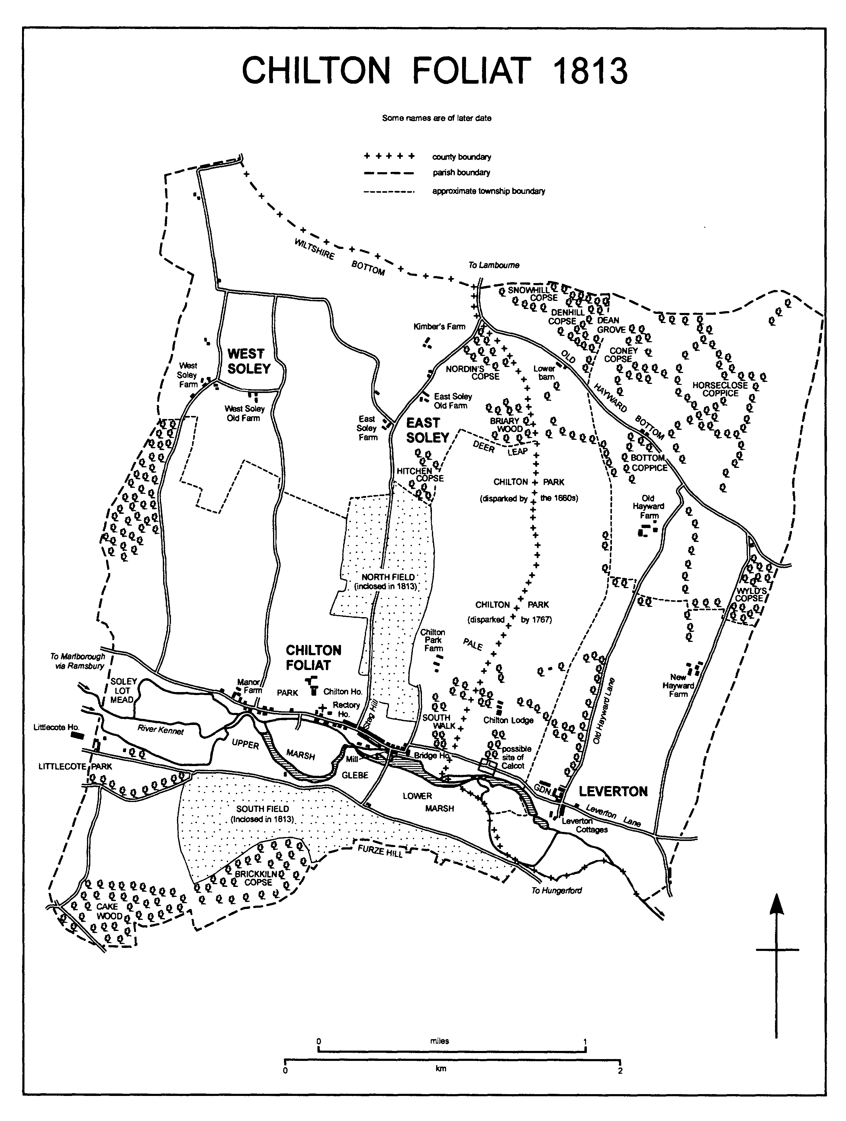
CHILTON FOLIAT 1813
From the church east to where the road across the bridge joins the street at the mill most of the cottages now have red-brick fronts of the 18th century, many with decoration of black or grey brick. Older gable walls of flint rubble survive in some, and several bear signs of earlier timber framing and of having been raised to two storeys from one storey and attics; a few unreconstructed timber-framed and thatched cottages of the 17th century survive. Modern houses have also been built of red brick and have tiled roofs. On the north side of the street a red-brick house of c. 1700 has a four-bayed south entrance front, with a heavy dentilled cornice, and gables incorporating patterned brickwork. Nearby on the north side and at right angles to each other a terrace of four cottages, two of the 17th century and two of the 18th, and a terrace of three 18th-century cottages are called the Square. Also on the north side a nonconformist chapel, a school, (fn. 41) and a church room were built in the 19th century and a commercial garage was built in the 20th. The church room was built in 1895 (fn. 42) and by will Dame Dinah Pearce (d. 1918) gave the income from £300 to maintain it; in 1994 the income was used as the donor intended. (fn. 43) Red-brick buildings of a former tannery (fn. 44) and two 19th-century houses stood on the south side of the street in 1995. Also on the south side 9 old people's bungalows were built, 5 in 1959 (fn. 45) and 4 in 1974, (fn. 46) and 7 private houses were built in the early 1980s. (fn. 47)
East of the mill Bridge House (fn. 48) was built in the 18th century of red brick. Its principal feature is its south elevation in which there is a tall round-headed window in each of five regular bays; there is a sixth bay to the east. The windows were constructed to light two first-floor rooms, one of three bays and one of two. On the ground floor the five bays were taken up by a central hall, entered by a door below the central window of the five, and a room on each side of it: each has a low ceiling. A two-storeyed north corridor incorporating a stair turret serves the principal rooms and gives access to the minor ones at the east end. Between the service corridor and outbuildings on the south side of Leverton Lane a narrow yard was approached through a wide arch. The building, easily reached from Hungerford and several country mansions, may have been erected to provide assembly rooms or, facing a reach of the Kennet which was dammed to form a narrow lake, as a fishing lodge. The decoration and fittings of the principal rooms suggest that it was erected in the mid 18th century, probably in 1766, the date on rainwater heads. It was apparently in use as a house in the early 19th century (fn. 49) and was restored and altered in the mid 20th, when a new west entrance was made and the ground-floor rooms were rearranged to allow for it. (fn. 50) South of the mill on the west side of the Hungerford road a red-brick and thatched cottage was built in the 19th century.
Beside Stag Hill, built c. 1813, (fn. 51) a pair of cottages had been constructed on the east side near Chilton Foliat village by c. 1880, (fn. 52) and the village grew along the road in the 20th century. Also on the east side a house and three bungalows were built in the mid 20th century, (fn. 53) 8 council houses in 1950, and 20 private houses in the late 1980s and the 1990s. On the west side 8 council houses were built in the 1930s, 10 council houses and bungalows were built in 1954-5, (fn. 54) and a school was built later. (fn. 55)
There was an inn in the village in 1620 (fn. 56) and an inn called the Red Lion possibly stood there in 1679. (fn. 57) An inn called the Wheatsheaf standing in 1767 and 1773 had been demolished by 1792. (fn. 58) The Stag's Head was open in 1813, (fn. 59) gave a name to Stag Hill which was built immediately east of it, and was closed c. 1955. (fn. 60) A new Wheatsheaf had been opened by 1815; (fn. 61) as a red-brick and thatched building of the 18th century it remained open in 1995. The New inn was open in the 1840s and 1850s. (fn. 62)
A farmhouse said in 1767 to be newly built (fn. 63) is presumably that built in the 18th century of red brick c. 100 m. east of Chilton Foliat bridge and in Leverton Lane; it had possibly been converted to cottages by c. 1813 and had been by 1883. (fn. 64) Between 1814 and c. 1880 a short new section of the lane was built to avoid a sharp bend at the farmhouse, a pair of ornamental red-brick cottages was built on the north side of the new lane, and a block in vernacular style and consisting of a house and four cottages was built on the south side. (fn. 65) In 1995 a pair of early 20th-century brick, flint, and stone piers stood beside the lane.
Land east of Chilton Foliat village has been imparked probably since the Middle Ages, and a lodge stood in the park presumably on the site of Chilton Park Farm north-east of the village on the Wiltshire side of the county boundary. The house called Chilton Lodge on that site was enlarged in the later 17th century and demolished in the late 18th, when a new Chilton Lodge was built on the Berkshire side of the boundary. (fn. 66) A new red-brick farmhouse was built on the site of the old Chilton Lodge, possibly c. 1800. (fn. 67) It was demolished c. 1939 and replaced by Chilton Park Farm, a large neo-Georgian house of red brick with stone dressings, built in 1939-40 to designs by W. A. Forsyth. (fn. 68) A large timber-framed 18th-century barn stands north of the house.
East of the village a small farmstead on the south side of Leverton Lane was demolished probably c. 1800; (fn. 69) on the north side of the lane a lodge cottage for Chilton Lodge was built probably between 1890 and 1898. (fn. 70) South of the Kennet and west of the village outbuildings of Littlecote House stand in the parish, and in the mid 19th century a lodge was built 550 m. east of the parish boundary where the road from Hungerford becomes the main drive of the house. South of the road most of a 19th-century farmstead was demolished in the later 20th century. (fn. 71)
Soley.
In the Middle Ages, when it had open fields, (fn. 72) Soley may have been a small nucleated settlement. About 1240 it was called a hamlet. (fn. 73) East and West Soley were separate settlements in the later 16th century (fn. 74) and each may have consisted then, as it did in the later 18th century, of several farmsteads loosely grouped. (fn. 75) Since the later 18th century Straight Soley and Crooked Soley have been alternative names for East Soley and West Soley respectively. (fn. 76)
In the later 18th century three farmsteads stood at East Soley. (fn. 77) The farmhouse of only one, East Soley Farm, the southernmost, survives. It bears a reset date stone MS 1658, is partly timber-framed, and has been largely rebuilt in brick. Large new farm buildings were erected in the 20th century. The northernmost farmstead, Kimber's Farm, was demolished between 1813 and c. 1880. (fn. 78) That between East Soley Farm and Kimber's Farm was called East Soley Old Farm in 1995. In the 19th century the farmhouse was replaced by a new red-brick one; in the later 20th most of the farm buildings were demolished (fn. 79) and an indoor riding school was built. Between East Soley Old Farm and Kimber's Farm two cottages standing in 1791 were demolished between 1898 and 1922, and north of East Soley Farm a trio of cottages standing in 1791 (fn. 80) was rebuilt in the later 19th century.
In the later 18th century five farmsteads stood at West Soley. One, that in the north-west corner of the parish, was demolished between 1813 and 1830; (fn. 81) another, that between those later called West Soley Farm and West Soley Old Farm, was demolished between c. 1880 and 1898. (fn. 82) North of West Soley Farm a trio of red-brick cottages built in 1900 (fn. 83) marks the site of a third, demolished between 1830 and c. 1880. (fn. 84) West Soley Farm is an 18th-century house near which stands an 18th-century cottage of brick, flint, and thatch; a large 20th-century barn and former farm buildings of red brick stand nearby. A house of flint and brick, formerly two cottages (fn. 85) and possibly 18th-century, survives at West Soley Old Farm; in the late 20th century large stud farm buildings replaced the other buildings at the site. (fn. 86)
Calcot.
In 1086 and the earlier 14th century, when it was assessed separately for taxation, (fn. 87) Calcot was probably a small riverside settlement. It stood between Chilton Foliat and Leverton, (fn. 88) its precise site is unknown, and there is no evidence that it survived the Middle Ages. Between 1340 and the mid 16th century most of its land was taken into Chilton park, and a new Chilton Lodge was built on that land probably in the late 1790s. (fn. 89) Some of Calcot's land to the east remained farmland worked from Leverton or Old Hayward Farm, (fn. 90) some to the north farmland worked from East Soley and Old Hayward Farm. (fn. 91) On that to the north Lower barn was standing in Old Hayward bottom c. 1754. (fn. 92) A farmhouse was built at the site c. 1814. (fn. 93) The barn had been demolished by 1878; the farmhouse and a pair of cottages built between 1878 and 1898 (fn. 94) remained in 1995.
Leverton.
The village stood beside Leverton Lane and in the Middle Ages may have consisted of c. 13 small farmsteads, (fn. 95) possibly some in each of the quadrants at the crossing of Old Hayward Lane, running north-south between the downs and the Kennet, and Leverton Lane. From the later 17th century much of Leverton's land was worked from outside the village, (fn. 96) which was small in the mid 18th. (fn. 97) The last farmsteads to survive were one in the north-east quadrant demolished between 1814 and 1878 and one in the south-west quadrant demolished between 1898 and 1909; (fn. 98) in the north-west quadrant a surviving timber-framed and thatched cottage, encased in brick and rendered, was built on the waste (fn. 99) possibly in the 17th century.
Between 1767 and 1813 the farmstead called New Hayward Farm was built on the downs north-east of the village, the park of Chilton Lodge was extended eastwards to Old Hayward Lane and extensive walled kitchen gardens and a farmyard were built in the north-west quadrant of the crossroads, and a terrace of six red-brick and thatched estate cottages, later called Leverton Cottages, was built in the south-east quadrant. (fn. 100) New Hayward Farm, of which the farmhouse is of red brick with a three-bayed south entrance front and a rear service wing extended several times in the 19th century, had been built by 1791; (fn. 101) the other building was probably of the late 1790s. (fn. 102)
Each time in a style to match the first six, Leverton Cottages (fn. 103) was extended to eight between 1814 and 1878 and to 10 between 1898 and 1909. A gardener's house west of the walled gardens was built in the mid 19th century. Between 1878 and 1898 a pair of houses in vernacular style was built at the entrance to the farmyard from Old Hayward Lane, and in the north-east quadrant of the crossroads Leverton Manor, a large house of red brick, gabled and partly hung with tiles, was built c. 1900. In the late 19th century three cottages were built at New Hayward Farm; (fn. 104) in the later 20th they were replaced by a bungalow, farm buildings were converted for residence, two houses were built, and extensive new farm buildings were erected. (fn. 105)
Hayward.
Like Soley, Hayward may have been a settlement of several small farmsteads in the Middle Ages, when it had open fields. From the 16th century there is unlikely to have been more than a single farmstead, (fn. 106) that later called Old Hayward Farm. In the mid 18th century the farmstead was very large, (fn. 107) and in the early 19th it incorporated some large buildings. (fn. 108) It ceased to be used for agriculture in 1988. (fn. 109) The surviving farmhouse incorporates a house of one storey and attics, on a three-roomed plan, and probably timber-framed and 17th-century. The outer walls of that house were rebuilt in brick and flint at several dates. The house had been extended eastwards by the later 18th century, and was extended northwards in the late 18th century or early 19th, north-westwards in the mid 19th century, and further eastwards c. 1990.
In the later 18th century or early 19th, respectively north and east of Old Hayward Farm, two gamekeeper's lodges and a barn were built in Old Hayward bottom. A cottage was built near the barn c. 1814. (fn. 110) By 1878 the lodges had been replaced by kennels and a kennelman's house. (fn. 111) The house was being restored in 1995. A new cottage for a gamekeeper was built of brick, flint, and thatch near Old Hayward Farm in 1903. (fn. 112)
MANORS AND OTHER ESTATES.
In 1066 Earl Harold held what became CHILTON FOLIAT manor. In 1086 Rainbald held it of Miles Crispin (fn. 113) (d. 1107), (fn. 114) who also held Wallingford castle (Berks., later Oxon.). The manor became part of the honor of Wallingford, and those holding the castle remained overlords. (fn. 115)
The lordship in demesne may have been held by Ralph de St. German (possibly Ralph Foliot) in 1156, (fn. 116) and was probably held by Robert Foliot c. 1167. (fn. 117) The manor, which in the late 12th century or early 13th included Soley, passed to Ralph Foliot and from him to his brother Henry (d. by 1236). Henry's heir was his son Sampson (fn. 118) (fl. 1281), (fn. 119) who in 1249 was granted free warren in the demesne. (fn. 120) Joan (fl. 1282), the wife of Henry Tyeys (d. 1282), was probably Sampson's daughter, and by 1289 his estates had passed to his grandson, and Henry's son, Henry Tyeys (from 1289 Lord Tyeys, d. 1307). (fn. 121) Chilton Foliat manor was held as dower from 1307 by Henry's relict Hawise, who c. 1309 leased it to his son Henry, Lord Tyeys. In 1322 Henry was attainted and executed (fn. 122) and the king granted the manor to Hugh le Despenser when he created him earl of Winchester. (fn. 123) Hawise petitioned parliament for its return but died before the petition was heard. (fn. 124) In 1326 the king resumed the manor on Despenser's execution (fn. 125) and restored it to the younger Lord Tyeys's sister Alice (d. 1347), the relict of Sir Warin de Lisle, (fn. 126) from whom that Lord Tyeys's relict Margaret (d. 1349), the wife of Thomas de Monthermer, claimed a third of it as dower. (fn. 127) Alice was succeeded by her son Sir Gerard de Lisle (from 1357 Lord Lisle, d. 1360), whose relict Elizabeth (d. 1362), the wife of Richard Pembridge, held Chilton Foliat manor for life. The manor passed to Gerard's son Warin, Lord Lisle, who at his death in 1382 also held Calcot manor and Leverton manor. (fn. 128) The three manors were held by Warin's relict Joan (d. 1392) for life. They passed in 1392 to his daughter Margaret (d. 1392), the wife of Thomas Berkeley, Lord Berkeley (d. 1417), (fn. 129) in 1417 to Margaret's daughter Elizabeth (d. 1422), the wife of Richard de Beauchamp, earl of Warwick (d. 1439), (fn. 130) and soon after 1439 to one of Elizabeth's three daughters Eleanor, the relict of Thomas de Ros, Lord Ros, the wife of Edmund Beaufort (cr. earl of Dorset 1442 and marquess of Dorset 1443, earl of Somerset from 1444, cr. duke of Somerset 1448, d. 1455), and later possibly the wife of Walter Rokesley. (fn. 131) Eleanor's sons Thomas de Ros, Lord Ros, and Henry Beaufort, duke of Somerset, were attainted in 1461 and executed in 1464, and her grandson Edmund de Ros, Lord Ros, and her son Edmund Beaufort were thus disinherited. (fn. 132) From 1467, when Eleanor died, until 1505 her estates seem to have been held by her seven daughters, their husbands, and their heirs as coparceners. (fn. 133) Eleanor's grandson Henry Stafford, duke of Buckingham, evidently entered on Chilton Foliat, Calcot, and Leverton manors. Henry was executed and attainted in 1483, an Act of 1485 restored his lands to his son Edward, duke of Buckingham, (fn. 134) and Edward was later among the coparceners. (fn. 135) The estates of Thomas, Lord Ros (d. 1464), were restored to Edmund, Lord Ros (d. 1508), by Act in 1485, when Edmund was a lunatic, but were retained by the Crown during pleasure. (fn. 136) In 1505 the Crown resumed the three manors in Chilton Foliat parish as concealed lands, and from 1519 they were held as dower by successive queens consort. (fn. 137)
In 1546 the king sold Chilton Foliat manor, Chilton park, in which most of Calcot manor had apparently been subsumed, and Leverton manor to Sir Edward Darell of Littlecote House. (fn. 138) Nearly half the purchase money, £500, had not been paid when Darell died in 1549 leaving his son and heir William a ward of the king. (fn. 139) Presumably soon after 1549 Henry Manners, earl of Rutland, maintaining the right of his great-granduncle Edmund, Lord Ros, successfully claimed the estate against Darell and the Crown, (fn. 140) and in 1563 he died seised of it. (fn. 141) Between 1572 and 1574 Henry's son Edward, earl of Rutland, sold Chilton Foliat manor in c. 8 portions. The largest was bought in 1574 by Thomas Rosewell, (fn. 142) who between 1575 and 1578 sold that in c. 15 portions. (fn. 143) Many small estates thereafter descended separately, but by the early 19th century all except c. 150 a. of the parish had been agglomerated in the three principal estates. (fn. 144)
William Darell bought land south of the Kennet and near Littlecote House from Lord Rutland in 1572, (fn. 145) and, probably c. 1578, from Rosewell a rump of Chilton Foliat manor, almost certainly the manorial rights and the demesne farm; by 1587 he had bought two holdings at Soley. (fn. 146) As Chilton Foliat manor Darell's estate passed at his death in 1589 to Sir Francis Walsingham (d. 1590), to whom he had sold the reversion in that year. (fn. 147) Part of it, evidently the land near Littlecote House, the manorial rights, and the land at Soley, was settled on Walsingham's wife Ursula and later sold to Sir John Popham (d. 1607), the owner of Littlecote House, probably in 1591 by Ursula and Walsingham's daughter Frances and her husband Robert Devereux, earl of Essex. (fn. 148) That reduced manor passed with Littlecote House until the 20th century. It descended in the direct line to Sir Francis Popham (d. 1644), Alexander (d. 1669), Sir Francis (d. 1674), and Alexander (d. 1705), who was succeeded by his uncle Alexander Popham (d. 1705), and again passed in the direct line to Francis (d. 1735), Edward (d. 1772), and Francis (d. 1780), from the death of whose widow Dorothy Popham c. 1797 it passed to her husband's reputed son Francis Popham (d. s.p. 1804). In 1800 Francis sold 102 a. to John Pearse, who added it to the Chilton Lodge estate, and in 1813 Francis's successor E. W. Leyborne-Popham owned 902 a. in the parish. (fn. 149) Between 1813 and 1879 Leyborne-Popham's estate was more than doubled in size. (fn. 150) After his death in 1843 most of it was held with Littlecote House by his son Francis (d. 1880), a smaller part by his son E. W. Leyborne-Popham (d. s.p. 1881). Francis's son F. W. LeybornePopham (d. s.p. 1907) inherited both parts (fn. 151) and in 1896 sold Manor farm and farms at West Soley, a total of c. 565 a., to V. J. Watney. (fn. 152) Francis was succeeded by his brother H. F. A. Leyborne-Popham, who bought Watney's land after 1910. In 1929 Leyborne-Popham sold all his land in Chilton Foliat, c. 1,830 a., to Sir Ernest Wills, Bt., as part of the Littlecote estate. (fn. 153) Wills (d. 1958) was succeeded by his son G. S. Wills (d. 1979), who in 1965 gave the estate to his son (David) Seton Wills (Bt. from 1983), the owner of c. 560 a. in the south-west part of the parish in 1995. (fn. 154) In 1956 Sir Ernest sold Briary wood and c. 60 a. east of Chilton Foliat bridge to E. J. S. Ward, and in 1979 Sir Seton sold 71 a. north of Chilton Park Farm to Mr. G. J. Ward: (fn. 155) the lands sold were added to the Chilton Lodge estate. (fn. 156) In 1978 Sir Seton sold West Soley farm, 532 a. including c. 150 a. outside the parish, to R. A. Pearce, who in 1981 sold 135 a., thereafter West Soley Stud farm, to Mr. Justin Hayward, and in 1982 sold 82 a. to Mr. A. T. Pearce, the owner of that land in 1995, and 312 a., including the land outside the parish, to Mr. P. A. C. L. Oppenheim. In 1995 Miss Sandy Pflueger owned West Soley Stud farm and most of Oppenheim's land in the parish. In 1978 Sir Seton sold Manor farm, 310 a., to Mrs. V. M. Pearce and East Soley farm, 264 a., to her son Mr. A. T. Pearce. In 1995 all that land, the 82 a. bought in 1982, and 60 a. outside the parish belonged to Mr. Pearce as East Soley farm, c. 725 a. (fn. 157) In 1986 Sir Seton sold c. 43 a. with Littlecote House to Mr. P. J. de Savary, the owner in 1995. (fn. 158)
An estate consisting of the medieval manor house of Chilton Foliat, or its site, and what was apparently a large inclosed demesne farm and former park (fn. 159) were the nucleus of the CHILTON HOUSE estate. It seems that in 1590 Sir Francis Walsingham conveyed the estate to his secretary Francis Mylles (d. 1618) (fn. 160) and that it passed to Mylles's daughter Philippa, whose husband, the courtier John Packer (d. 1649), held it in 1623. It descended to Philippa's son John Packer, (fn. 161) and in 1689, when it included land at Soley, John sold the estate to Lovelace Bigg (fn. 162) (d. 1725). (fn. 163) It passed in turn to Bigg's sons Henry (d. 1740), from 1730 warden of Winchester College, Thomas (will proved 1761), and the Revd. Walter Bigg (d. 1772), and it descended to Walter's son Lovelace (from 1789 Lovelace Bigg Wither). (fn. 164) It was enlarged several times. (fn. 165) In 1792 Bigg Wither sold it to the Revd. John Craven (fn. 166) (d. 1804), (fn. 167) who also enlarged it. (fn. 168) In 1813 Craven's son and heir Fulwar owned 756 a. in the parish. (fn. 169) In 1834 he sold the estate, 877 a., to E. W. Leyborne-Popham, who added it to the Littlecote estate. (fn. 170)
Members of the Foliot and Tyeys families may have lived at Chilton Foliat, where Alice de Lisle imparked and, she said in 1334, her ancestors were buried. (fn. 171) A manor house mentioned in 1546 (fn. 172) probably stood immediately west of the church. It was almost certainly the house lived in by Thomas Bigg and demolished c. 1754. Chilton House was built, evidently between 1755 and 1758 and probably immediately north of the old house's site, (fn. 173) was lived in by the Biggs and Cravens, (fn. 174) and was demolished in 1965. (fn. 175) It was a large three-storeyed red-brick building with an entrance through a canted bay at the south-west corner. The principal front was to the south, there were lower service wings to the north, and the roof pattern suggests that the original building had been enlarged. North of it there stood a large farm courtyard, (fn. 176) some buildings of which were converted for residence after 1965, and east of the rectory house lay a kitchen garden walled in red brick. (fn. 177)
In the late 12th century or early 13th Ralph Foliot granted a small estate in Soley to Roger Foliot; later and before c. 1210 Henry Foliot confirmed that estate to Roger's brother Richard and gave 1 yardland in Chilton Foliat to him, and Richard granted both estates to St. Frideswide's priory, Oxford. (fn. 178) The land was absorbed into the priory's adjoining manor of Eddington or Hidden, mainly in Hungerford. (fn. 179) On each occasion as part of that manor the land at Soley, c. 43 a. presumably with pasture rights, passed to the Crown at the dissolution of the priory in 1524, in 1525 was granted to Cardinal Wolsey for Cardinal College, Oxford, in 1532 was granted to King Henry VIII's College, Oxford, from 1545 was held by the Crown, and in 1599 was sold to trustees of Sir John Popham. From 1599 it apparently descended with the reduced Chilton Foliat manor. (fn. 180)
An estate said to be of c. 200 a. at Soley was held by William Bird and passed to the Crown on his attainder in 1540. Between 1546 and 1551 it was held by royal officials, presumably for their service, and in 1551 was granted to the Lady Elizabeth, (fn. 181) from 1558 Elizabeth I. In 1562 the queen sold the estate to Gilbert Sherrington and Thomas Blackwell, (fn. 182) presumably speculators or trustees, who immediately conveyed it to John Langley. In 1567 Langley sold it to Henry Parvis. It passed to Henry's son Jewell, and in 1594 his relict Jane conveyed her life interest to Jewell. (fn. 183) The estate was afterwards acquired by Thomas Smith and combined with his other estate at Soley. (fn. 184)
In 1575 Henry Smith bought an estate in West Soley from Thomas Rosewell. (fn. 185) It descended to his son Thomas, who by the early 17th century had acquired several other freeholds at Soley, including others formerly part of Chilton Foliat manor. Thomas Smith (d. 1637) settled his estate at Soley on the marriage of his daughter Mary (d. by 1654) and Charles Seymour (from 1664 Lord Seymour, d. 1665). It descended to Mary's daughter Frances, the wife of Sir George Hungerford, (fn. 186) and, apparently between 1707 and 1710, the Hungerfords sold it to William Lewis le Grand. (fn. 187) The estate passed to Edward le Grand, who, apparently before 1773, sold it to Lovelace Bigg (later Bigg Wither) or one of his predecessors: (fn. 188) it became part of the Chilton House estate. (fn. 189)
In 1066 Brictuard held CALCOT. William I gave it to William, count of Évreux (d. 1118), and William gave it to a conventual priory of the abbey of St. Évroul which in 1108 he founded at Noyon-sur-Andelle (now Charleval, Eure). (fn. 190) The priory held the manor in demesne until 1243; thereafter it was overlord. (fn. 191)
In 1243 Noyon priory sold Calcot manor to Alan of Farnham, whose heir was his daughter Gillian, the wife of Gilbert of Elsfield and later of John de St. Helen. On the evidence of jurors who in 1275 testified that Alan had acquired the manor by forcing two freeholders (sokemen of the king) from the land, the king claimed it from John and Gillian in 1280, but in 1282 Alan's right to it was proved. By 1289 John and Gillian had settled the manor on Gillian's grandson Alan Elsfield, (fn. 192) and in 1305 John Elsfield conveyed it to his own son Gilbert. (fn. 193) In 1316-17 Gilbert conveyed it to Henry, Lord Tyeys, and Henry's wife Margaret for life. In 1322, on Tyeys's attainder and execution, the life interest passed to the Crown; in 1325 it was restored to Margaret (d. 1349), who as Margaret de Monthermer, (fn. 194) held the manor in 1341. (fn. 195) Warin, Lord Lisle, held it in fee at his death in 1382. (fn. 196) It thereafter descended with Chilton Foliat manor and by the 16th century had apparently been merged with it. (fn. 197)
Much of the land of Calcot manor and land of Chilton Foliat manor were the components of Chilton park, (fn. 198) in which there was a lodge, (fn. 199) and the nucleus of the CHILTON LODGE estate. In 1574 Edward, earl of Rutland, sold Chilton park, with Leverton manor, to Anthony Hinton (d. 1599), (fn. 200) the owner of Hayward manor. (fn. 201) Anthony's composite Chilton Lodge estate, to which Eddington manor had been added by 1623, (fn. 202) descended to his son (Sir) Thomas (d. 1635) and to Sir Thomas's son (Sir) Anthony, (fn. 203) who in 1639 sold it to Thomas Hussey (fn. 204) (d. 1657-8). (fn. 205) In 1663 Thomas's son William, relict Catherine, the wife of Sir Robert Mason, executors, and trustees sold it to the lawyer, politician, and diarist Sir Bulstrode Whitelocke (d. 1675). (fn. 206) It descended to Sir Bulstrode's son Samuel (d. 1690) (fn. 207) and in the direct line to Samuel (d. 1743) (fn. 208) and John Whitelocke, who in 1767 sold it to J. Z. Holwell, a survivor of the Black Hole of Calcutta. (fn. 209) In 1771 Holwell sold the estate to Gen. Richard Smith, (fn. 210) who in 1785 sold it to John Macnamara. (fn. 211) In 1788 Macnamara sold it to the mortgagees William Morland and Thomas Hammersley, bankers of Pall Mall, and in 1789 Hammersley released his interest to Morland. (fn. 212) In 1796 Morland sold the estate to John Pearse, a director of the Bank of England and from 1818 to 1832 M.P. for Devizes, (fn. 213) who in 1813 owned 1,488 a. in the parish. (fn. 214) In 1834 Pearse sold the estate to the Revd. Sir William Cooper, Bt. (fn. 215) (will proved 1835). (fn. 216) It was devised by Sir William to his wife Isabella (fn. 217) (d. 1855) and by Isabella to her and Sir William's grandson William Honywood, (fn. 218) who sold it in 1890 to Sir William Pearce, Bt. (d. 1907). Pearce devised it for sale after the death of his wife Caroline (d. 1907), (fn. 219) and his executors sold it in 1908 to H. W. Henderson. In 1909 the estate was bought from Henderson by (Sir) John Ward (d. 1938) and his wife Jean (d. 1962). It passed in 1938 to the Wards' son E. J. S. Ward (d. 1990) and in 1967 to E. J. S. Ward's son Mr. G. J. Ward, the owner in 1995. (fn. 220)
A lodge in Chilton park in 1546 (fn. 221) and part of the Chilton Lodge estate from 1574 (fn. 222) presumably stood on or near the site of Chilton Park Farm, where Chilton Lodge stood until the late 18th century. (fn. 223) Chilton Lodge, almost certainly the house called Chilton Park lived in by Sir Thomas Hinton in the 1620s and 1630s (fn. 224) and by Thomas Hussey in the 1640s, (fn. 225) was enlarged by Sir Bulstrode Whitelocke in the 1660s: work was done on the drawing room in 1664 and the house was much extended in 1667-8 when a new hall and bedrooms were built. (fn. 226) Until 1785 or later the house was lived in by Whitelocke's successors as owners of the estate. (fn. 227) It is unlikely to have been rebuilt before 1789, probably the year in which it was demolished. (fn. 228) In that year, when William Morland became sole owner of the estate, (fn. 229) the foundations of a new house, which Morland commissioned (Sir) John Soane to build, were being set out. (fn. 230) The new house was probably on the site of the old, (fn. 231) and its form was dictated by Morland's instruction to Soane to re-use materials from demolished buildings, presumably those of the old house. It was a villa with a two-storeyed centre and short single-storeyed wings. (fn. 232) It was demolished, probably before 1800, and was replaced by a new and much larger Chilton Lodge built for John Pearse, the owner of the estate from 1796: the house called Chilton Lodge in which Pearse lived in 1800 was probably the new one. (fn. 233) Two other houses afterwards occupied the site of the old Chilton Lodge. (fn. 234) The new Chilton Lodge was designed by William Pilkington (fn. 235) and was built south-east of the site of Chilton Park Farm and in what was then or soon afterwards the centre of the park. (fn. 236) It was built with a south front and a west front each of five bays, the south incorporating a full-height Corinthian portico, with an east front of seven bays, and with a large north stable court. (fn. 237) A large north-west pavilion was built between 1890 and 1892 for Sir William Pearce to designs by Sir Arthur Blomfield (fn. 238) and was demolished c. 1963. A porte cochère removed from the east side of the house c. 1963 (fn. 239) may also have been designed by Blomfield.
In the 1660s and probably near the house Sir Bulstrode Whitelocke laid out new walled gardens, one with a terraced walk; a pond for trout was dug, (fn. 240) possibly the pond which lay in 1814 on the county boundary east of the site of the house. (fn. 241) Formal gardens survived south-west of the house in the later 18th century, (fn. 242) when there was also a haha. (fn. 243) The park was estimated at 360 a. in 1663, (fn. 244) but later in the 1660s pales were taken down, (fn. 245) and later there was a smaller paled park stocked with deer. (fn. 246) In the 17th century an avenue called the South walk led from the house to Leverton Lane. (fn. 247) In the mid 18th century there was also an avenue which led east from the house, and from the east end of that avenue another, parallel to the South walk, which led to Leverton Lane. (fn. 248) Most of the park, however, was then used for agriculture, and in 1767 only 24 a. and woodland were held with Chilton Lodge. (fn. 249) Land near Chilton Lodge was again imparked c. 1777, (fn. 250) and between then and 1813 the park was extended eastwards. The Chilton Lodge built for John Pearse stands in the centre of the extended park, (fn. 251) which is therefore likely to have been extended between 1796 and 1800. (fn. 252) The principal avenues of the 18th century, but not the South walk, have survived and in 1995 framed the landscape south-west of the house. The features of the extension probably of the late 18th century, including an eastern boundary plantation and across the centre a curving belt of woodland called the Shrubbery, (fn. 253) are less regular.
In 1666 a new gate was erected at the bottom of the South walk, and gate piers erected in 1667 may have stood at that entrance. (fn. 254) From c. 1800 the main entrance to the park was presumably where the eastern avenue met Leverton Lane: (fn. 255) west of that avenue the lodge and entrance gates standing in Leverton Lane in 1995 were of the late 19th century. (fn. 256) A farmyard and the walls of a kitchen garden of c. 4 a. stand in the south-east corner of the park: they were apparently built in the late 18th century, and the size of the garden suggests that they are contemporary with Pearse's house. The kitchen garden was restored in the 1980s. (fn. 257)
The northernmost part of Calcot manor, not in Chilton park, was apparently added to an estate at Soley and, 70 a., was among the lands sold by Francis Popham to John Pearse in 1800. (fn. 258) The other part not in the park, c. 50 a. evidently lying east of the park, was sold by Lord Rutland to Anthony Hinton in 1574. (fn. 259)
In 984 LEVERTON, then described as 8 mansae beside the Kennet formerly held by Etheric, a villein (rusticus), was granted by King Ethelred to Bryhtric. King Edward allegedly granted or confirmed it to Abingdon abbey (Berks., later Oxon.) in 1050, (fn. 260) and in 1066 it was held of the abbey by Blacheman, a priest. On Blacheman's flight from England with King Harold's mother in 1068 William I confiscated the estate, and the abbey recovered it from him only, it was said, after much difficulty. Hezelin held Leverton of the abbey in 1086, (fn. 261) as did Gueres de Palence probably in the 12th century, (fn. 262) and the abbey remained overlord in the 15th century. (fn. 263)
Leverton manor evidently descended from Robert de Wancey to Geoffrey de Wancey (fl. c. 1160-70), to William de Wancey (fl. c. 1180-90), and in turn to William de Wancey (fl. c. 1220-30) and his son Geoffrey. What was apparently the northern part of it was granted away by the second William (fn. 264) and became a separate manor. (fn. 265) The second Geoffrey held the reduced Leverton manor in 1242-3, (fn. 266) Stephen de Hamville held it in 1292, (fn. 267) and Alan Hamville held it in 1341. (fn. 268) In 1343 Alan granted it to James Hussey for James's life, a grant ratified by Alan's son Thomas, (fn. 269) and by 1373 Warin, Lord Lisle, had acquired it in fee. (fn. 270) The manor thereafter descended with Chilton Foliat manor and from 1574 was part of the Chilton Lodge estate. (fn. 271)
Land granted to Littlemore priory (Oxon.) by William de Wancey in the earlier 13th century (fn. 272) became HAYWARD manor. The priory held the manor in 1242-3 (fn. 273) and until its dissolution in 1525. In 1526 the manor was granted to Cardinal Wolsey for the endowment of Cardinal College (fn. 274) and, when the college was refounded in 1532 as King Henry VIII's College, was granted to the new college. In 1545 it was among the college's estates surrendered to the king, (fn. 275) who in 1546 gave it by exchange to his physician George Owen. (fn. 276) In 1547 Owen sold the manor to Sir John Williams, the treasurer of the court of Augmentations, who in 1551 sold it to Owen Oglethorpe. In 1552 Oglethorpe sold it to Thomas Hinton (fn. 277) (d. 1567). It descended to Hinton's son Anthony (fn. 278) and since 1574 has been part of the Chilton Lodge estate. (fn. 279)
At its dissolution in 1525 Poughley priory in Chaddleworth (Berks.) owned land, probably no more than 1 a., at Leverton. As part of the priory's manor of Bagnor, in Speen (Berks.), in 1526 the land was granted to Cardinal Wolsey for Cardinal College, in 1529 resumed by the king, in 1531 granted to Westminster abbey, and in 1542 transferred to the dean and chapter of Westminster. It was held of the dean and chapter by copy, measured 1 a. c. 1870, and was enfranchised in 1890. (fn. 280)
ECONOMIC HISTORY.
Chilton Foliat.
In 1086 Chilton Foliat had enough land for 12 ploughteams, but only 7 teams were there: on 6½ hides of demesne there were 2 servi and 2 teams, and 7 villani and 10 coscets had 5 teams. There were 2 square furlongs of both meadow and pasture; the woodland measured 1 league by 2 furlongs. (fn. 281) The demesne, evidently understocked with teams, apparently included a large area of uncultivated downland, (fn. 282) presumably that used to found the settlements at Soley and Cakewood and to provide them with agricultural land. By the early 13th century Chilton Foliat's land had been divided into two, probably three, agricultural units: to the north Soley had c. 800 a., to the south-west Cakewood probably had 100-200 a., and Chilton Foliat was left with c. 1,200-1,300 a. (fn. 283) Cakewood's open fields, probably c. 100 a., were shared by five tenants each holding 1 yardland; (fn. 284) the hamlet had apparently been deserted by the 16th century, from when the land was used in severally. (fn. 285)
By the early 14th century some of Chilton Foliat's land had been imparked. (fn. 286) The imparking may have been contemporary with a grant of free warren over the demesne land made in 1249, (fn. 287) and the park may have been the square, of c. 350-400 a. with the church and the manor house in the south-east corner, bounded by Soley's land, North field, the Marlborough road, and the western parish boundary. (fn. 288) The agricultural land of the demesne, 130 a. of arable and 20 a. of meadow, was scanty in 1307. (fn. 289) The park reverted to common pasture in winter, (fn. 290) and by 1327, when the demesne included 380 a. of arable, 31 a. of meadow, and pasture worth 6s. 8d., it may again have been cultivated. (fn. 291) There is no later evidence of common rights over that square, which thereafter seems to have been the land of an inclosed demesne farm. (fn. 292) It was apparently used for sport in the 17th century, (fn. 293) and in the early 19th included near Chilton House 25 a. called a park. (fn. 294) On the east, parts of the square may have been added to other farms in the 1570s. (fn. 295) All the remaining agricultural land was presumably worked from buildings at Chilton House until, in the later 18th century and before 1791, Manor Farm was built on the north side of the Marlborough road and to the west. (fn. 296) Between Manor Farm and the Kennet 19 a. of inclosed meadows was part of the farm. (fn. 297)
In 1336 a licence was granted for 400 a. at Chilton Foliat to be imparked, (fn. 298) and by 1341 a carucate had been inclosed as a park in which game was preserved. (fn. 299) The land imparked c. 1340 was probably the strip between North field and the county boundary: there were deer in the park in 1483, (fn. 300) the park keeper was paid 2d. a day in 1539, (fn. 301) and a lodge stood on it in 1546 presumably on the site of Chilton Park Farm. (fn. 302) By the 16th century much of Calcot's land, a similar strip on the other side of the county boundary, had been added to the park, 360 a. around Chilton Lodge in the 17th century. (fn. 303)
In the early 13th century there may have been meadow beside the Kennet watered and used in common, (fn. 304) and c. 1550 the tenants of Chilton Foliat manor claimed the hay of, and winter pasture in, Chilton mead, 37 a., a claim denied by the lord of the manor. (fn. 305) The claim seems to have failed: west of Upper marsh the meadows, c. 60 a. excluding Soley Lot mead, (fn. 306) were later used in severalty as demesne, and the rector had 11 a. of inclosed meadow east of Upper marsh. (fn. 307) From 1572 Lord's mead, 40 a., 60 a. of woodland, Cakewood field, and Cakewood closes, a total of c. 290 a. in the south-west corner of the parish and near Littlecote House, were held in severalty as part of the house's parkland, of a home farm, or of a tenanted farm based in Ramsbury. (fn. 308)
On Chilton Foliat manor in 1327 there were 4 free tenants and 44 bond tenants and cottars, (fn. 309) some of whom presumably lived at Soley; 32 tenants claimed the rights in Chilton mead c. 1550. (fn. 310) The land at Chilton Foliat divided among holdings which until the 1570s were customary consisted of two open fields, North, 141 a. in a strip running north from the east part of the village, and South, 144 a., lying east-west south of the Kennet, and of two commonable marshes beside the Kennet, Upper, 30 a. southwest of the village, and Lower, 47 a. south-east of the village. (fn. 311) In the later 17th century 4 a. of North field was inclosed and added to the Chilton Lodge park. (fn. 312) Most of the copyholds were sold separately in the 1570s. (fn. 313) The holdings based at Chilton Foliat, consisting of land in both the open fields and of pasture rights for cattle in the marshes, were evidently small, without meadow land, and with pasture for sheep only in the open fields. (fn. 314) In the 1570s some of them may have had part of the demesne farm added to them, and in 1772 the largest known, 44 a., included 14 a. of inclosed arable, 7 a. in 4 parcels in North field, 19 a. in 9 parcels in South field, 3 a. of inclosed grassland, and feeding for 9 cows in the marshes. (fn. 315) Most were presumably worked from small farmsteads in the street, but in 1777 Morgan's farm included, besides 11 a. in the open fields, a farmstead in Leverton Lane and 13 a. in closes near Chilton Lodge. (fn. 316) The closes of Morgan's farm were absorbed by the Chilton Lodge park, (fn. 317) and by the early 19th century most of the small farms had been acquired by the owners of Littlecote House, Chilton House, and Chilton Lodge. (fn. 318)
In 1813 the open fields and the marshes were inclosed by Act and land was exchanged. South of the Kennet the Lower marsh was to be converted to water meadow, and South field was added to the roughly 290 a. in the south-west corner and worked from outside the parish. North of the Kennet the Upper marsh was added to Manor farm, separate farms may have been worked from Chilton House and Manor Farm, and 77 a. may have been worked from a farmstead in the street. (fn. 319) By 1835 Chilton House farm had been added to Manor farm, c. 400 a., which was held by the tenant of an adjoining farm based at West Soley, and the farm based in the street had been increased to 107 a. (fn. 320) In the later 19th century a stud farm, 164 a. in 1896, was based north of the street at the east end, (fn. 321) and land south of the Kennet was worked from Littlecote Home Farm, which had been built on the former South field by c. 1880. (fn. 322)
In 1929 south of the Kennet 35 a. was held with Littlecote House, Littlecote Home farm measured 159 a., and Littlecote Park farm, based in Ramsbury, included 116 a. in Chilton Foliat; north of the Kennet, Manor farm measured 273 a. and Chilton Stud farm 178 a. (fn. 323) In the 1920s and 1930s Manor farm and West Soley farm were held together. (fn. 324) In 1961 south of the Kennet Littlecote Park farm included 124 a., 75 a. of grassland was held with Littlecote House or let for grazing, and Littlecote Home farm, 75 a., was mainly arable. North of the Kennet and all mainly arable, Manor farm, 180 a., and Chilton Stud farm, 245 a., were worked with East Soley farm and West Soley farm respectively. (fn. 325) In 1995 south of the Kennet c. 225 a. of arable was in hand as part of the Eastridge (formerly Littlecote) estate, and c. 20 a. of grassland was held with Littlecote House. (fn. 326) North of the Kennet most of the land was arable: that east of Stag Hill was worked from New Hayward Farm, 178 a. west of Stag Hill was in hand as part of the Eastridge estate, and the remainder was part of East Soley farm. (fn. 327)
Three coppices in the south-west corner of the parish in 1572 probably included the east part of Cake wood and the west part of Brickkiln copse: (fn. 328) in 1813 and 1995 c. 50 a. of each of those woods was in Chilton Foliat. (fn. 329) Cake wood, held by the Ministry of Agriculture and Fisheries from 1953 (fn. 330) and by the Forestry Commission in 1995, was replanted with beech and Norway spruce in the early 1960s. (fn. 331) Woods beside the western boundary of the parish adjoining Foxbury wood in Ramsbury were standing in the later 18th century (fn. 332) and probably much earlier. They measured c. 46 a. in 1813, (fn. 333) 42 a. in 1922 (fn. 334) and 1995, when they were called Daffy copse. A belt of trees had been planted around 27 a. of parkland near Littlecote House by 1773, (fn. 335) and in the 20th century two coppices, each of c. 4 a., were planted east of Daffy copse. (fn. 336)
There were two mills at Chilton Foliat in 1086, (fn. 337) and a water mill, presumably for grain, and a fulling mill, presumably driven by water, stood on Chilton Foliat manor in the early 14th century. (fn. 338) A fulling mill remained on the manor until the 17th century. (fn. 339) The corn mill was rebuilt in the 17th century (fn. 340) and, with an attached miller's house, in the early 19th: it remained in use until the 1930s. (fn. 341)
A tanner may have lived at Chilton Foliat in the earlier 15th century, (fn. 342) and there was a tannery in the village from 1620 or earlier. In 1680 it was used by a collar maker, (fn. 343) and from 1704 or earlier it stood on the south side of the street. (fn. 344) The tannery remained in use until c. 1850: (fn. 345) the buildings which survived in 1995 were apparently of c. 1800. There was a malthouse in the village from the early 18th century to the later 19th; it stood on the south side of the street in the early 19th century. (fn. 346) In the 19th century premises in the street were used for a wide variety of trades to serve local needs. (fn. 347)
Soley.
Almost certainly between 1086 and 1200 what was apparently uncultivated downland, c. 800 a., was presumably assigned to Soley as agricultural land. (fn. 348) Soley had open fields called East and West, a common pasture called the Heath on which sheep were fed, and, beside the Kennet and detached from its other land, a common meadow in which plots were divided by merestones and assigned by lot. (fn. 349) In the 16th century and probably earlier much of the land was in copyholds of Chilton Foliat manor. (fn. 350)
Soley's open fields were inclosed between 1585 and 1603, probably c. 1600. The Heath had possibly been inclosed by 1585, when a holding included Heath close, 4 a., and had been divided, allotted, and inclosed by 1600. (fn. 351) Soley Lot mead, 17 a., was inclosed by Act in 1813. (fn. 352)
In 1791 there were three farmsteads at East Soley, five at West Soley: one farm consisted of 127 a. in 21 closes and of half a lot in Soley Lot mead, and one based at East Soley included Lower barn and c. 56 a. of Calcot's land in Old Hayward bottom. (fn. 353) About 1813 there were farms of 169 a., 108 a., and 92 a. based at East Soley, of 135 a., 133 a., and 62 a. based at West Soley; all were predominantly arable. (fn. 354) By 1835 the farms had been reduced to four based at the sites later called East Soley Farm, East Soley Old Farm, West Soley Farm, and West Soley Old Farm. One of the farms based at West Soley, of 148 a. and probably that based at West Soley Old Farm, was held by the tenant of Manor farm, Chilton Foliat; the others were of 220 a., 217 a., and 209 a. (fn. 355)
In 1896 two farms, of 218 a. and 191 a., were based at East Soley and one of 376 a. was based at West Soley Farm. (fn. 356) The two East Soley farms were held as one from 1910 or earlier, and in the 1920s and 1930s West Soley farm was held with Manor farm. (fn. 357) In the 1960s East Soley farm measured 608 a. including Manor farm; West Soley farm, 384 a., was held with Chilton Stud farm and land at Thrup in Ramsbury, a total of 786 a.; both were mainly arable, (fn. 358) and their fields were greatly enlarged in the later 20th century. East Soley farm, including Manor farm, 82 a. formerly in West Soley farm, and 60 a. outside the parish, a total of c. 725 a., was still mainly arable in 1995. West Soley farm, without Chilton Stud farm from 1978, was reduced to 312 a. in 1982 and afterwards split up. A 135-a. stud farm based at West Soley Old Farm was started in 1981 and later enlarged; extensive new buildings were erected c. 1990, and in 1995 the farm measured c. 200 a. From c. 1990 the Raffin Stud, based at Thrup, had c. 48 a. in the north-west corner of Chilton Foliat parish. (fn. 359)
In 1773 the only woodland at Soley was Nordin's copse, 14 a. north-east of East Soley. (fn. 360) By 1791 Briary wood, 14 a., and Hitchen copse, 10 a., had been planted respectively east and south-east of East Soley, (fn. 361) and between c. 1880 and 1898 Queen's coppice, 17 a., was planted south of West Soley. Nordin's copse and the south half of Hitchen copse were grubbed up between 1813 and c. 1880. (fn. 362) The other woodland was standing in 1995.
Calcot and Chilton park.
Calcot's land was not extensive. In 1086 it was sufficient for 2 teams and was assessed at 1 hide; the demesne had 1 team on it, 3 villani and 4 bordars shared 1 team, and there were 5 a. of meadow. (fn. 363) The land lay as a strip of c. 300 a. along the east side of the county boundary and north of the Kennet, with Leverton's land east of it and Chilton Foliat's west. (fn. 364) Until 1341 or later Calcot manor probably comprised demesne and customary land in open fields, and meadow and pasture used in common. (fn. 365) About 1340 a strip of land probably on the west side of the county boundary and bounded to the north by Soley was imparked, (fn. 366) and by 1439, when Calcot manor was said to include 120 a. of arable, 70 a. of pasture, and 6 a. of woodland, either a comparable strip of its land or its woodland had been encompassed by Chilton park. (fn. 367) By the 16th century Calcot village had almost certainly ceased to exist (fn. 368) and, except for two closes called Calcot, 39 a., part of Leverton farm in 1574, and presumably east of the park, and for c. 70 a. north of the park, all its land had been encompassed by Chilton park. (fn. 369) The two closes, 59 a. in 1663, (fn. 370) seem to have been taken into the park when it was enlarged eastwards, probably in the late 1790s. (fn. 371) The land north of the park was probably worked from East Soley in the late 16th century, (fn. 372) as it was until the late 18th. A farmhouse was built on it c. 1814, when as Dunnels farm it was probably of c. 70 a. and mainly arable. (fn. 373) In the mid 19th century Dunnels farm was 74 a., (fn. 374) in the later 19th 143 a. (fn. 375) By 1908 it had been absorbed by Old Hayward farm (fn. 376) and its land was later in hand as part of the Chilton Lodge estate and worked from New Hayward Farm. (fn. 377)
Chilton park, 315 a. in 1619, (fn. 378) 360 a. in 1663, (fn. 379) was divided from Chilton Foliat's North field to the west by pales; (fn. 380) a deer leap which existed in the early 19th century marked what in the 16th was the park's boundary with Soley to the north. (fn. 381) In the 1660s pales were taken down and the northern part of the park, 137 a., was added to Hayward farm and presumably converted to agriculture; in the small park which remained deer were hunted and partridges shot. (fn. 382) In the 18th century much of the small park was also used for agriculture. In 1767 only 24 a. and woodland were held with Chilton Lodge, and Chilton Park farm, 252 a., was worked from a farmhouse then said to be new; (fn. 383) the farmhouse was probably that which stands c. 100 m. east of Chilton Foliat bridge. (fn. 384) Land near Chilton Lodge was imparked c. 1777 (fn. 385) and, to surround the new Chilton Lodge, the park was extended eastwards probably in the late 1790s. (fn. 386) Since c. 1800 the rectangular park, 160 a., has been bounded on the south by Leverton Lane and on the east by Old Hayward Lane. Its northern boundary runs east from the site of the old Chilton Lodge at its north-east corner and was marked by a pale in the earlier 19th century. In 1813 Chilton Park farm, 186 a. including 154 a. of arable, lay between that pale and the land which was presumably converted to agriculture in the 1660s; it was worked from a new farmhouse which had replaced the old Chilton Lodge. Model farm buildings which had been erected in the south-east corner of the park by 1813 (fn. 387) incorporated a dairy. Chilton Park farm, 182 a., included 7 a. of water meadow and 37 a. of pasture in 1908. (fn. 388) By 1938 it had been brought in hand as part of the Chilton Lodge estate and in 1995 was used for arable and dairy farming. (fn. 389) In 1995 cattle were kept in Chilton park but the model farm buildings had no agricultural use.
In 1086 Calcot had woodland enough only for fencing. (fn. 390) Dean grove was standing in 1577. (fn. 391) Denhill copse, adjoining it, and Snowhill copse were standing c. 1754. (fn. 392) The woods measured 7 a., 14 a., and 7 a. respectively in 1813: (fn. 393) none had changed much in area by 1995. There was little woodland in the park in the 18th century although there were avenues in several parts of it. The Shrubbery, 8 a. of woodland, and a belt of trees beside Old Hayward Lane were planted in the new part of the park probably in the late 1790s, (fn. 394) and Tower wood, 29 a., was planted NNE. of Chilton Lodge mainly between c. 1880 and 1898. (fn. 395)
A mill stood at Calcot in 1086, (fn. 396) in 1243, when it was intended to raise the dams of the pond and build a fulling mill, (fn. 397) and in 1305. (fn. 398) No later mill has been traced.
Leverton.
In 1086 Leverton was assessed at 4½ hides. It had enough land for 4 teams but only 3 were there, 1 on the demesne and 2 shared by 4 villani and 3 bordars; 2 servi there probably worked on the demesne. (fn. 399) Like Chilton Foliat's, Leverton's demesne seems to have been understocked with teams and may also have included uncultivated downland to the north. Downland separated from Leverton manor in the earlier 13th century apparently became Hayward's agricultural land, (fn. 400) c. 500 a.; Leverton was left with c. 500 a. in the south-east corner of the parish. (fn. 401)
Cultivation in open fields probably continued at Leverton until the 18th century, (fn. 402) and meadow land may have been used in common in the 17th; (fn. 403) the other grassland had evidently been inclosed by the 16th century. In 1574 the demesne farm of Leverton manor included c. 120 a. in the open fields, the first cut of 7 a. of meadow, and c. 80 a. of inclosed meadow and pasture including the two closes called Calcot, and a copyhold included 16 a. in the open fields and 6 a. of inclosed grassland. (fn. 404) The copyholds, of which there were c. 13, were worked from farmsteads in Leverton village, (fn. 405) and the demesne was almost certainly worked from a farmstead there.
Leverton had c. 45 a. of meadows and in 1665, when 32 a. was held with Chilton Lodge, a new weir was built for watering some or all of them. By 1663 most of the demesne had been added to Hayward farm. (fn. 406) All the arable had possibly been inclosed by 1738, when an apparently recent inclosure of 5 a. of East field was men tioned, (fn. 407) and evidently had been by 1767. In 1767 the copyholds included 117 a. lying north and east of the village. Between 1767 and 1791 New Hayward Farm was built on the north part of Leverton's land, and in 1813 a long and narrow farm of 443 a., including land in the north-east corner of the parish, was worked from it; 390 a. of the farm was arable. (fn. 408) A strip of c. 60 a. on the west side of Old Hayward Lane was taken into Chilton park when it was extended probably in the late 1790s, (fn. 409) and in the early 19th century only Leverton farm, 68 a., and a smaller farm were worked from farmsteads in the village. (fn. 410) About 1884 New Hayward farm measured 470 a., Leverton farm 73 a. (fn. 411) By 1909 the farm buildings in the village had been demolished; the land of Leverton farm was then worked from buildings east of the village as Upper Eddington farm, 66 a. In 1909 New Hayward farm measured 381 a. including 60 a. of grassland. (fn. 412) It was in hand from 1967, and in the later 20th century New Hayward Farm became the base from which all the agricultural land of the Chilton Lodge estate was worked. Extensive farm buildings were erected and in 1995 an arable and dairy farm of c. 2,300 a. was worked from them. (fn. 413)
In 1086 Leverton had woodland for 2 swine. (fn. 414) Most of it probably stood on the downland assigned to Hayward. Downs copse, 15 a., was the only woodland in the mid 18th century and had been grubbed up by 1814. (fn. 415) Some of the wood planted in Chilton park probably in the late 1790s (fn. 416) was on Leverton's land and, adjoining the north-east corner of the park, Park plantation, 19 a., was grown between c. 1880 and 1898. (fn. 417)
A mill stood at Leverton in 1086 and 1292, (fn. 418) and a water mill stood there in 1343 and the earlier 15th century. (fn. 419) There was a malthouse in the village in the later 18th century. (fn. 420)
Hayward.
The 500 a. in the north-east corner of the parish may have been rough pasture until separated from Leverton manor in the early 13th century. (fn. 421) Open fields were laid out, sheep and cattle were fed in common, and, as meadow land apparently was to Soley in similar circumstances, Hayward mead, 16 a. beside the Kennet, was probably assigned to Hayward at the separation. Hayward manor evidently included a demesne farm and customary tenants, (fn. 422) but in the 16th century or earlier apparently all the land was brought into Hayward farm and common husbandry thus eliminated. (fn. 423) By 1663, when it was 620 a., Hayward farm had been extended southwards by the addition of most of the demesne of Leverton manor, (fn. 424) and in 1664 it was extended westwards by the addition of the 137 a. of Calcot and Chilton Foliat until then the northern part of Chilton Foliat park. (fn. 425) In 1767 it was a several farm of c. 807 a. with land in c. 31 fields and with 30 a. of watered meadow. Between 1767 and 1791 much of its land was transferred to New Hayward farm. (fn. 426) As Old Hayward farm it measured 398 a., including 334 a. of arable, in 1813. (fn. 427) In the mid 19th century it measured 436 a., (fn. 428) in the later 19th 356 a. (fn. 429) Old Hayward farm had absorbed Dunnels farm by 1908, when it was a mainly arable farm of 433 a. (fn. 430) It was brought in hand as part of the Chilton Lodge estate in the 1970s, and in 1995 its land was worked from New Hayward Farm and devoted to arable and dairying. (fn. 431)
Hayward has long been well wooded. In 1663 Coney copse, Horseclose coppice, Bottom coppice, and Wyld's copse were all standing; (fn. 432) in 1813 they measured 16 a., 17 a., 10 a., and 19 a. respectively. In 1663 there may also have been some smaller coppices and some belts of trees linking some of the coppices, as there were in 1813. (fn. 433) In the 19th century Bottom coppice was enlarged to c. 30 a., partly by merger with other woodland, and between c. 1880 and 1898 Horseclose coppice was increased to c. 50 a. and c. 3 a. of woodland was planted to adjoin Briary wood in Soley. (fn. 434) In the later 20th century c. 10 a. of Wyld's copse was grubbed up, (fn. 435) and in 1995 there was c. 110 a. of woodland at Hayward.
LOCAL GOVERNMENT.
Chilton Foliat tithing, which excluded the Berkshire part of the parish and in the 17th century or earlier included East and West Soley, (fn. 436) attended the view of frankpledge held for the honor of Wallingford, despite the claim by Henry, Lord Tyeys, in 1289 to have the assize of bread and of ale in Chilton Foliat. (fn. 437) St. Frideswide's priory's tenants in Chilton Foliat and Soley, however, attended the priory's biannual court, probably a view, of Eddington manor, (fn. 438) and in the mid 13th century Alan of Farnham caused his men of Calcot to withdraw their suit from Kintbury hundred. (fn. 439) In the 15th century the tithingman of Chilton Foliat presented at the view held for the honor of Wallingford at Ogbourne St. George: brewers who broke the assize were the offenders most frequently amerced. (fn. 440) About 1520 Chilton Foliat withdrew its suit at the command of Queen Catherine, the lord of the manor. (fn. 441) A court leet was held for Chilton Foliat in the 18th and 19th centuries (fn. 442) but none of its records is extant. A court of Chilton Foliat manor was held from the 14th century to the 16th. (fn. 443) There was little if any copyhold business to be done after the sale of the manor in portions in the period 1572-8; (fn. 444) other business was presumably done at the court leet.
As parts of different counties Chilton Foliat tithing and Calcot and Leverton tithing, which included Hayward, levied separate poor rates. In the 17th century it seems that they elected separate pairs of overseers, but that the Chilton Foliat overseers, who received payments from the Leverton overseers, relieved the poor of the whole parish. (fn. 445) In the early 19th century, when two thirds of the expenditure was met from Chilton Foliat tithing, the rates were still collected separately but there was only one pair of overseers. (fn. 446)
In 1666-7 £14 8s. was spent on poor relief, in the 1670s an average of c. £32 was spent, and in the 1680s and 1690s, for example at £77 in 1686-7 and £65 in 1692-3, expenditure was sometimes higher. In the 17th century most money was spent on weekly doles, rents were paid, and fuel, food, and clothing were bought. In the earlier 18th the cost of extraordinary items sometimes exceeded that of doles: in 1724-5 £16 was spent on extraordinaries, including clothing, fuel, funerals, and a pair of spectacles, £14 on doles for c. 5 paupers, and £10 on rents. (fn. 447) In 1775-6 £302 was spent on poor relief, in the early 1780s an average of £395. In 1802-3, when the poor rate was above average for Kinwardstone hundred, £422 was spent on relieving 72 adults and 76 children regularly and 45 people occasionally. (fn. 448) Expenditure rose rapidly in the early 19th century and, probably c. 1804, the parish acquired a poorhouse or workhouse and began to employ a salaried assistant overseer, who was also the resident governor of the poorhouse: in 1810-11, when c. 48 received weekly payments, £841 was spent. (fn. 449) In 1812-13 £1,333 was spent and 63 were relieved regularly and 30 occasionally. Nine of the 31 relieved regularly in 1814-15 lived in the poorhouse. (fn. 450) From c. 1818 expenditure decreased and in the 1820s it averaged £750. (fn. 451) The poorhouse remained open and the overseers continued to give doles and to pay for clothing, footwear, and other necessities. There were c. 12 in the poorhouse in 1827. (fn. 452) Expenditure was slightly higher in the 1830s; (fn. 453) the poorhouse remained open until the parish joined Hungerford poor-law union in 1835. (fn. 454)
The parish became part of Hungerford rural district in 1872. From 1895 the Wiltshire part lay in Ramsbury rural district, (fn. 455) from 1974 in Kennet district. The Berkshire part lay in Newbury district from 1974. (fn. 456)
In 1813 the vestry ordered a lockup to be built: no physical evidence of one survives. (fn. 457) Stocks standing in Leverton village were renewed in 1994. (fn. 458)
CHURCH.
Chilton Foliat church was probably standing in the 12th century. (fn. 459) The rectory was added to Whitton benefice in 1976. (fn. 460) The Berkshire part of the parish was exempted from the transfer of Berkshire from Salisbury diocese to Oxford diocese in 1836 (fn. 461) and, although transferred to Hungerford civil parish in 1895, (fn. 462) remains part of Chilton Foliat ecclesiastical parish. (fn. 463)
From the earlier 14th century or earlier to the 1570s the advowson of the rectory belonged to the lord of Chilton Foliat manor. (fn. 464) Sir Gilbert Talbot presented in 1386 and 1389, (fn. 465) possibly as a feoffee of Joan de Lisle, and in 1487 Thomas Warren presented by grant of a turn. Edward Burgh, Lord Burgh, a grandson of Eleanor, duchess of Somerset (d. 1467), and a coparcener of the manor, presented in 1496, and Margaret, countess of Richmond, Henry VII's mother, presented in 1499 by Edward's grant. The Crown, which resumed the manor in 1505, presented in 1507, 1508, and 1509, and the queen, who held the manor as dower, presented in 1521. (fn. 466) After the death of Henry, earl of Rutland, the lord of Chilton Foliat manor, in 1563 John James and Alexander Rosewell disputed the right to present by Henry's grant of a turn: (fn. 467) in 1566 the bishop collated by lapse, and the Crown presented in 1567, while Henry's son Edward, earl of Rutland, was a minor. (fn. 468) The advowson was bought from Edward by Thomas Rosewell in 1574. (fn. 469) In 1578 it was conveyed by Alexander Rosewell to Peter Rosewell (fn. 470) (d. 1579), whose son and heir James was a minor until 1587. (fn. 471) By 1589 the advowson had apparently been acquired by William Darell, and it presumably passed with the rump of Chilton Foliat manor to Sir John Popham, (fn. 472) who presented in 1598. It thereafter descended with the manor and Littlecote House, on the sale of which in 1929 it was kept by H. F. A. Leyborne-Popham (fn. 473) (d. 1943). It passed to Leyborne-Popham's nephew E. T. Buller, from 1943 E. T. Buller LeybornePopham (d. 1973). Buller Leyborne-Popham's executors held the advowson until 1976, (fn. 474) but no successor to his title was a member of the board of patronage set up for Whitton benefice in that year. (fn. 475)
At £9 in 1291 (fn. 476) and at £14 8s. 8½d. in 1535 (fn. 477) the church was highly valued, at £994 c. 1830 very highly valued. (fn. 478) The rector was entitled to all tithes from the whole parish; (fn. 479) in 1811 nearly all of them were valued at £919 and commuted. (fn. 480) There was c. 10 a. of glebe in 1608 and c. 1700. (fn. 481) At inclosure in 1813 the rector's inclosed land was increased from 13 a. to 30 a. by allotments to replace a few acres in the open fields, feeding rights in common, and some tithes. (fn. 482) The rector sold 19 a. in 1928, 11 a. in 1967. (fn. 483) The rectory house of the late 16th century or early 17th was probably timber-framed. Of its central range and two cross wings only parts of the west wing survive, but almost the complete plan is marked out by existing walls. (fn. 484) Early in the 17th century a south range, of flint rubble with dressings of ashlar and brick, was added to the front of the east wing. The main south front was rebuilt in brick in the earlier 18th century and a north staircase block was added between the main range and the kitchen range to the west. Later in that century a canted bay was added to the south of the early 17th-century range, the side windows of which were blocked. Then or early in the 19th century the space between the wings at the back was filled and service rooms were added on the west of the house. Extensive alterations to the inside in the later 20th century were partly in 18th-century style. The house was sold in 1963, (fn. 485) when a new rectory house was built. (fn. 486)
Two chantries had been founded in the church by 1334, when Alice de Lisle was licensed to exhume the corpses of her brother, Henry, Lord Tyeys, and of her husband, Sir Warin de Lisle, and rebury them at Chilton Foliat. (fn. 487) There were chantry chaplains from 1335 to 1397 or later: in 1397 there were two, as presumably there had been since 1335. Walter of Salford presented a chaplain in 1335, the bishop presented in 1351, when the rectory may have been vacant, and in 1384, and the rector presented at seven other times. Richard Fanelore, rector from 1389, presented his own successor as chaplain. (fn. 488) No chaplain is known to have been appointed in the 15th century and a chapel in the parish church, presumably that in which both chantries were served, was demolished between 1549 and 1556. (fn. 489)
Until the Dissolution a light in the church was paid for with the income, 2s. in 1548, from ½ a. of meadow and 1 a. in open fields. (fn. 490) Richard Fanelore, rector 1389-97 and formerly one of the chantry chaplains, seems to have lived in the parish and to have managed the glebe farm directly. (fn. 491) Thomas Balgay, rector from c. 1530 to 1566, (fn. 492) was employing a curate in 1553. (fn. 493) In 1577 the church had a Bible, Erasmus's Paraphrases, three books of homilies, and other books. (fn. 494) Robert Collard was rector from 1598 to 1648. (fn. 495) The ministers in the Interregnum were Thomas Hounsell (d. 1658) and James Hounsell, probably his son, who was a commissioner for ejecting scandalous and negligent ministers. (fn. 496) James was himself ejected at the Restoration but continued to preach at Chilton Lodge until 1670. In the later 17th century the rector was often assisted by a curate. Grindall Sheafe, rector from 1662, is said to have sent a spy to a conventicle, at which James Hounsell preached, held at Chilton Lodge in 1666. (fn. 497) Timothy Topping, rector 1680-1708, was also rector of Thruxton (Hants). (fn. 498) Edward Popham, rector 1779-1815, was also vicar of Lacock, where he lived in 1783: (fn. 499) in 1812 he lived in Chilton Foliat rectory house. (fn. 500) Each Sunday in 1783 at Chilton Foliat the curate held two services, at one of which he preached. He held additional services at Christmas, on Good Friday, and, if he wished, on Fridays in Lent, and he held communion four times a year with c. 40 communicants. Each Sunday in Lent the schoolchildren were examined in the catechism. The curate was Edward Meyrick, who kept a school at Hungerford and later at Ramsbury; in 1812 the curate was his son Arthur, who kept the school at Ramsbury from 1811. (fn. 501) John Leyborne-Popham, rector 1835-72, lived in the rectory house and usually employed an assistant curate. Attendance at the two services on Census Sunday in 1851, 260 in the morning, 220 in the afternoon, was about the average for 1850-1. In 1864 there was a service in the church every day, morning prayers on weekdays and two services each Sunday. Communion was celebrated c. 25 times: c. 90 attended each celebration at the great festivals, 20-40 the others. Leyborne-Popham favoured the teaching of the catechism, in which children were still examined in Lent. (fn. 502) From 1966 to 1975 the living was held in plurality with Froxfield vicarage. The incumbent lived at Chilton Foliat, (fn. 503) as did the team rector of Whitton benefice in 1995.
By 1577 a stall of bees and 1 a. had been given to the church. (fn. 504) The land was presumably the 1 a. later held by the rector's churchwarden (fn. 505) and sold in 1933. (fn. 506)
The church of ST. MARY, so called in 1763, (fn. 507) is built of flint, ashlar, and rubble and is partly rendered. It consists of a chancel with north vestry, a nave with south aisle and south porch, and a west tower. The nave is long, has a thick north wall, and was probably built in the 12th century; there are reset fragments of 12thcentury billet moulding above the windows in the upper stage of the tower. The aisle may have been built in the 13th century, and an early 14th-century window survives in the north wall of the nave. A mid 14th-century window survives in the north wall of the chancel near its east end: its position suggests either that the chancel was lengthened or rebuilt at that date, or that the chapel which was demolished in the mid 16th century (fn. 508) stood on that side of the chancel at its west end. The tower may be 15thcentury. Three windows made in the north wall of the nave in the 15th century (fn. 509) were replaced in the 19th. The arcade, aisle, and tower were among the parts of the church affected by an extensive reconstruction of c. 1629 paid for by John Packer. (fn. 510) A new roof for the nave, a screen for the chancel, and box pews were apparently constructed then, and a gallery was erected in 1694. (fn. 511) In 1845, to designs by Benjamin Ferrey, the aisle was replaced by a wider one, the vestry was built, and an east window was made; (fn. 512) about then the nave roof was extensively restored, the box pews were replaced by open pews facing east, (fn. 513) and the gallery was rebuilt. A reredos in Jacobean style was fitted in 1926 and added to in 1931-2. (fn. 514) A neo-classical mausoleum for members of the Pearse family was built before 1814, almost certainly in the early 19th century, to designs by William Pilkington; (fn. 515) in 1995 it stood in the churchyard north of the chancel.
A 6½-oz. chalice was kept in 1553 when 4½ oz. of plate was taken for the king. A chalice and stand given in 1699, two chalices given in 1796, and a paten were replaced in 1862 by a chalice, a paten, a flagon, an almsdish, and a spoon, all of silver-gilt. (fn. 516) The church retains the plate given in 1862. (fn. 517)
Three bells hung in the church in 1553 and 1834. (fn. 518) A plan of 1699 to recast the bells as a large bell and a sanctus bell was presumably ineffective. (fn. 519) The ring was increased to five in 1844, when a treble and a second cast by Thomas Mears at London were added to a bell of 1663 cast by William Purdue at Salisbury, a tenor of 1742 cast by Henry Bagley probably at Witney (Oxon.), and a bell of 1771 cast by Robert Wells at Aldbourne. (fn. 520) Those five bells hung in the church in 1995, (fn. 521) having been repaired and rehung in 1932-3 (fn. 522) and 1962. (fn. 523)
The parish registers are complete from 1575; registrations of baptisms begin c. 1569. (fn. 524)
NONCONFORMITY.
Sir Bulstrode Whitelocke, who lived at Chilton Lodge 1663- 75, supported Independency. He attended Chilton Foliat church regularly and, often on a Sunday on which he went to church, held conventicles at his house. Those preaching at the conventicles included James Hounsell, the minister ejected from Chilton Foliat at the Restoration, George Cokayn, Whitelocke himself, and James Pearson, a member of Whitelocke's household. (fn. 525) In 1672 a room in the house was licensed as a Congregational meeting place, and at the first meeting after the licence was received Cokayn and Pearson preached to a congregation including strangers from Hungerford and Ramsbury. Whitelocke claimed that at one of the meetings in 1674 Cokayn preached to a congregation of c. 300. (fn. 526) The meetings almost certainly ceased on Whitelocke's death: in 1676 there was said to be no more than two nonconformists among the adult males of the parish (fn. 527) and in 1683 there was possibly no more than a reputed Quaker. (fn. 528) A Quaker and eight members of his family lived in the parish in 1783. (fn. 529)
In 1794 a house was certified for meetings of Methodists, and in 1796 a medium-sized redbrick Methodist chapel was built. In 1820 a licence was also granted for Methodists to meet in a courtyard, and a meeting house for Independents was certified in 1832. (fn. 530) The one service in the Methodist chapel on Census Sunday in 1851 was attended by 58, (fn. 531) and the rector said in 1864 that there were only c. 24 Wesleyans or Independents in the parish. (fn. 532) The chapel was enlarged in 1932 (fn. 533) and was closed between 1988 and 1994. (fn. 534)
EDUCATION.
In 1770 Roger Spanswick and his wife Elizabeth, according to the wish of Elizabeth's aunt Sarah Smith, gave the income from £600 stock to pay for 16 poor children of the parish to be taught. From 1771 a schoolmaster was given £16 a year to teach boys the elements and to pay a woman to teach girls reading, household work, and plainwork: surplus income was to be spent on books. (fn. 535) At his request £100 stock of the estate of the Revd. Walter Bigg (d. 1772) was added to the endowment by his administrator in 1772. (fn. 536) The school was to be open from the later of 7 a.m. or sunrise, on four days of the week to 5 p.m. and to noon on two. It was to be closed on Sundays and on seven other days of the year, including the king's birthday. It is likely that the master also accepted private boarding pupils (fn. 537) and that he held the charity school in his own house. (fn. 538) In 1783 the children were being taught the catechism at the school, the conduct of which, according to the curate, himself a schoolmaster, had recently improved. (fn. 539) The schoolmaster was being paid £20 a year in the early 19th century. (fn. 540) In 1816 he refused to teach, and the school was closed, because all the trustees holding the endowment had died; the school was reopened in 1817 when Chancery appointed new trustees. In 1818 a mistress received £20 for teaching 8 boys and 8 girls, and there were another 12-14 pupils in her school; c. 40 children were taught at two other schools in the parish, and 40 attended a National school recently opened at Hungerford. (fn. 541) In 1833 there were still three schools in the parish with a total of 41 pupils, and c. 16 children still attended Hungerford National school. (fn. 542)
A National school in Chilton Foliat was opened in 1835 (fn. 543) and, on the north side of the street, a new building for it was erected in 1847. (fn. 544) In 1857 that school had 60-70 pupils, and 20-30 children were taught in two dame schools. (fn. 545) There were 66 pupils at the National school on return day in 1871, (fn. 546) 87 on the roll and two teachers in 1902. (fn. 547) Average attendance fell from 81 in 1906 (fn. 548) with some fluctuations to 56 in 1937-8. (fn. 549) The income from Spanswick's charity, £18 in 1904, was given to the school. (fn. 550) In 1970 a new primary school was built in Stag Hill and the old one closed. (fn. 551) The school had 99 pupils on the roll in 1995. (fn. 552)
CHARITIES FOR THE POOR.
In the later 16th century two or three small sums of money, from one of which the rector was to give 2s. 6d. a year for clothing, were held as stock for the poor, (fn. 553) but apparently no eleemosynary charity endured.
By will proved 1856 Sarah Hawkins gave the interest from £179 for clothes, food, or fuel to be given to the poor yearly. In the earlier 20th century the income, c. £5 a year, was spent on coal, small amounts of which were given to many parishioners: in 1910, for example, 80 cwt. was shared among 60. In the mid 20th century small gifts of money were made instead: 3s. was given to each of 32 elderly people in 1955. (fn. 554) Money from the Ellen Wilson Fund (fn. 555) was added to the charity's income from 1961, and in the 1960s coal was again distributed. (fn. 556)
Dame Dinah Pearce (d. 1918) gave by will £200 stock for the sick and poor of Chilton Foliat parish: the gift was on condition that the trustees maintained her son's and his wife's tomb at Chilton Foliat. (fn. 557) In the early 1920s most of the income was spent on weekly doles of 1s. for 3-4 pensioners; later it was given to a general fund for the sick and poor. (fn. 558)
In the 1990s Chilton Foliat parish council managed Hawkins's and Pearce's eleemosynary charities, Bethell's fire-engine charity, Dame Dinah Pearce's church-room charity, and two charities for the general benefit of the parish, the Ellen Wilson Memorial Fund set up by S. G. Chamberlain in 1959 and the Dora, Lady Romilly, Fund set up by William Romilly, Lord Romilly, in 1962. In 1994 the income from all the charities was £446: £168 was spent on gifts distributed to old people at Christmas. (fn. 559)