A History of the County of Wiltshire: Volume 16, Kinwardstone Hundred. Originally published by Victoria County History, London, 1999.
This free content was digitised by double rekeying. All rights reserved.
'Chute', in A History of the County of Wiltshire: Volume 16, Kinwardstone Hundred, (London, 1999) pp. 108-120. British History Online https://www.british-history.ac.uk/vch/wilts/vol16/pp108-120 [accessed 24 April 2024]
In this section
CHUTE
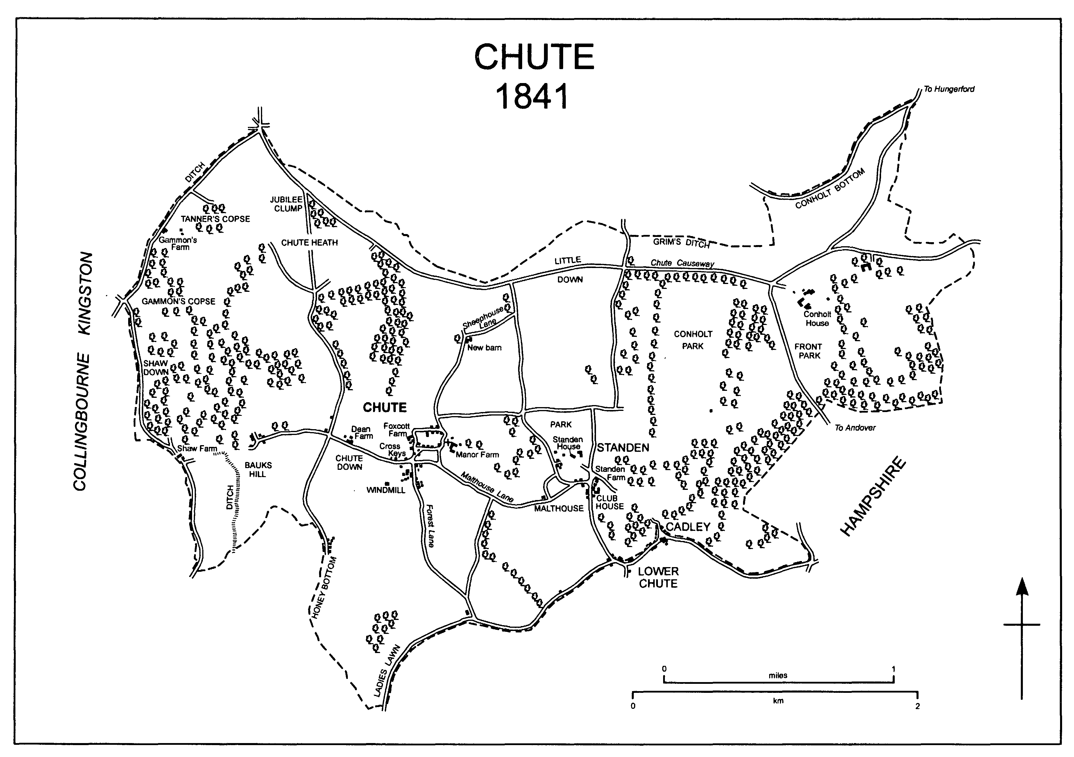
CHUTE 1841
Chute parish, (fn. 1) 1,318 ha. (3,256 a.), lies c. 10 km. north-west of Andover (Hants). It contained villages and hamlets named Chute, Cadley, Lower Chute, Conholt, Shaw, and Standen: in the 20th century the epithet Upper was added to the name Chute and, to distinguish them from eponymous settlements elsewhere in Wiltshire, the word Chute was added as a prefix to the names Cadley and Standen. The names as they were c. 1900 are used throughout this article. (fn. 2)
From the 14th century the parish was bordered by Chute forest on the north, south, and east. On the north the boundary followed a probably prehistoric ditch, the bottom of a deep dry valley, and, for a short distance, a Roman road. On the south it ignored relief; it was apparently marked by a road in the 14th century and was in the 17th century and later; to the west it was settled in 1809 by commissioners under an Act of 1808. On the east the parish boundary is Wiltshire's boundary with Hampshire; that the county boundary was apparently less intricate in the 14th century than it was in the 19th suggests that part of Chute forest was transferred to the parish from Hampshire after 1330. On the west the parish boundary follows a prehistoric ditch for c. 1 km. and, further south, two dry valleys. (fn. 3)
Chalk outcrops over the whole parish, in which no stream runs. The land falls from north to south and is broken by, mainly north-south, ridges and dry valleys. The only flat land is the highest, that along the northern boundary where it reaches 255 m. and clay-with-flints overlies the chalk. Gravel has been deposited in Conholt bottom, the deep valley followed by the northern boundary. The lowest land in the parish is at c. 125 m. at its southernmost point. (fn. 4) In the Middle Ages Chute, probably Conholt and Standen, and possibly Shaw had open fields. Extensive common pasture lay in the west part of the parish, and woodland stood in most parts. (fn. 5)
There were apparently 129 poll-tax payers in the parish in 1377. (fn. 6) In 1801 the population numbered 389. It rose steadily to reach its peak of 571 in 1851 and declined steadily to reach 388 in 1891. From 410 in 1911 it had declined to 301 by 1931, and from 329 in 1951 (fn. 7) to 275 by 1961. The population numbered 309 in 1991. (fn. 8)
The Roman road between Cirencester and Winchester deviates south-westwards from its otherwise straight course to avoid broken relief: part of the straight course and much of the deviation cross Chute parish (fn. 9) and were in use as roads in 1997. Some of the straight course in the parish was a section of a road between Hungerford (Berks.) and Andover; the rest went out of use when, before the later 18th century, the land which it crossed west of Conholt House was imparked. (fn. 10) The deviation, on the high ground near the parish's northern boundary, was called the Causeway or Causeway Lane in 1841, (fn. 11) Chute Causeway in 1997. A new section of the Andover road was made between 1820 and 1841 to take traffic away from Conholt House. (fn. 12) No road across the parish was turnpiked, and no major road crossed it in 1997. The pattern of lanes, most of which ran north-south with the relief, changed little between the later 18th century and the late 20th. Sheephouse Lane, leading north from Chute village, was apparently made between 1773 and 1817. (fn. 13) An east-west road linking Chute and Standen was called Malthouse Lane in 1841 (fn. 14) and later.
Four barrows in the parish have been identified, all in the west part. The ditch which marks the north part of the parish's western boundary is older than the Roman road; Grim's ditch, which marks the northern boundary, is probably prehistoric, and there is another prehistoric ditch near the western boundary. Two prehistoric field systems in the south-west part of the parish have been identified. (fn. 15)
The whole parish lay in Chute forest in the 13th century. It was disafforested in 1330. (fn. 16)
Chute.
In the Middle Ages Chute village probably consisted of the church, the demesne farmstead of Chute manor immediately east of it, a vicarage house north-west of it, and the farmsteads of the customary holdings of the manor in a short lane west of it. There was apparently a small green at the west end of the lane. (fn. 17)
Manor Farm, the demesne farmhouse, was apparently large in the later 18th century, when it had a small formal garden east of it. (fn. 18) In 1897 it was called Chute Manor and was apparently a house built in the late 17th century and altered in the earlier or mid 19th; it had a canted entrance bay in the middle of its main front. (fn. 19) It was demolished in the mid 20th century. (fn. 20) In 1997 modern farm buildings and large buildings of brick and flint stood east of the church. In 1841 a small farmstead, including a house later called Parsonage Farm, stood near the vicarage house; (fn. 21) the house, apparently 18th-century, was standing in 1997, when the farm buildings included some apparently of the 19th century and some of the 20th. An 18th-century thatched cottage stood nearby. In 1841 only two farmsteads stood west of the church. The farm buildings of one of them, Foxcott Farm, which stood north of the green at the end of the lane, had been demolished by 1879, (fn. 22) and the farmhouse, possibly 18th-century, had been converted to a pair of cottages by the late 19th century. (fn. 23) A thatched house of the 18th century, two large 19th-century houses, one of brick and flint, and a 20th-century house stood in the lane in 1997. A building on the east part of the green was replaced by a pair of cottages built in 1904. (fn. 24)
South-west of the church cottages were built from the 18th century or earlier on waste ground from which a lane later called Forest Lane led southwards. In 1841 c. 25 cottages stood there, (fn. 25) and a nonconformist chapel was built in the later 19th century. (fn. 26) Several cottages built of rubble and thatch in the 18th century or earlier survived in 1997. Other cottages were replaced in the 20th century.
At its west end Malthouse Lane bifurcates: one branch leads north to the church, the other west along the north edge of the waste ground on which the cottages stood in 1841. On the south side of the west branch a thatched house was built, probably in the 18th century, and a brick and flint house was built in the 19th; west of those houses and on the north side of the lane the Cross Keys was probably built in the early 19th century and was open as a public house from 1822 (fn. 27) or earlier and in 1997.
The two parts of Chute village were linked by 20th-century building between the west branch of Malthouse Lane and the lane leading west from the church. The rural district council built 4 houses there in 1930, (fn. 28) 4 houses in 1950, (fn. 29) and 2 bungalows later, and 17 private houses were built in the 1990s. In 1975 the village was designated a conservation area. (fn. 30)
Cadley and Lower Chute.
Two small settlements, mainly of cottages built on common pasture, had grown up along the southern boundary of the parish by the 18th century, and by the later 18th century buildings had been erected beside the road linking them. Other buildings were later erected on the small allotments into which the common was divided in 1820. (fn. 31) Several of the buildings of each settlement, and those on the south side of the road, stood in Chute Forest parish.
At Cadley, north-east of Lower Chute, the cottages were built around a steeply sloping triangular green, on which in the 19th and 20th centuries there was a pond. (fn. 32) Around the green in 1841 there stood 13 cottages and houses, two of which were each divided into three tenements. (fn. 33) The cottages and houses standing in 1997 included several built of brick and flint between the 17th century and the early 19th and a pair of estate cottages built in the 1930s. In the later 18th century and earlier 19th a small group of cottages north of the green was apparently called Hatchett; the cottages had been demolished by 1841. (fn. 34)
At Lower Chute 10 cottages and houses, one divided into four tenements, were standing in 1841. (fn. 35) Those surviving in 1997 included an 18th-century house with walls of chalk, flint, and timber, a thatched cottage of the 18th century or earlier, and a possibly 17th-century house, of a single storey and attics and with a thatched roof, open in 1901 or earlier and in 1997 as the Hatchet public house. (fn. 36) The building divided into four tenements was replaced by a house built in 1879 and open as the Star public house from the 1880s until 1939 (fn. 37) or later.
Several buildings were standing on both sides of the road between Cadley and Lower Chute in 1773. (fn. 38) A nonconformist chapel astride the boundary with Chute Forest was built in the mid 19th century. (fn. 39) The cottages and houses standing in 1997 included a mid 18th-century house of knapped flint with brick dressings and a thatched roof, three thatched cottages apparently of the 18th century or earlier, and several 20th-century houses and bungalows.
The north-east and south-west line of settlement was extended in both those directions in the 20th century. To the north-east Home Farm, incorporating a house, farm buildings, and a pair and a trio of cottages, was built c. 1905. To the south-west a British Legion club had been built by 1923 (fn. 40) and eight houses and bungalows were built. The club was later enlarged and was open in 1997. The south-west extension embraced an apparently 18th-century thatched cottage and a pair of mid 19th-century cottages. (fn. 41)
The combined settlement, except the two extensions, was designated a conservation area in 1994. (fn. 42)
Conholt may have been a small village in the 13th century, when Conholt manor included 17 customary tenants. (fn. 43) The site of such a village has not been identified, and by the 16th century there may have been no more than four farmsteads on Conholt's land. (fn. 44) By the later 18th century much of the land had been imparked, and Conholt House, which is of 17th-century origin, its outbuildings immediately north of it, and a barn in the park were apparently the only buildings standing on it. (fn. 45) The barn had been demolished by 1817, (fn. 46) and between 1820 and 1841 a new farmyard, later called Middle Conholt Farm, was built north-east of Conholt House. (fn. 47) Between 1879 and 1899 two pairs of cottages were built, one beside the Andover road and one at Middle Conholt Farm. (fn. 48) Beside Chute Causeway a pair of cottages was built between 1899 and 1923 (fn. 49) and later demolished. At Middle Conholt Farm in the 20th century two pairs of cottages were built and farm buildings were renewed.
Shaw.
In the Middle Ages Shaw was probably a small settlement in the deep valley followed by the west boundary of the parish where a farmstead called Shaw Farm stood alone in 1773. (fn. 50) The farmhouse was destroyed by fire in the 1940s (fn. 51) and the last building was removed from the site in the late 20th century. (fn. 52)
Standen.
On a site where three valleys meet Standen was probably a small village in the Middle Ages. In the 17th century Standen Farm and a timber-framed and thatched house of that century, both of which survive, were standing on that site, and on high ground to the northwest Standen House is also of 17th-century origin. (fn. 53) A thatched lodge west of Standen House was built in the 18th century and was standing in 1997. In 1841 all those buildings, a few other houses, and a club room or school constituted the village. (fn. 54) Standen Farm, called the Dower House in 1997, is a brick and flint house of four bays on an L plan. An early 17th-century chimney stack stands between the two east bays; the west part of the house is mostly 18th-century. Extensions of the 20th century include one which links the house to a former outbuilding with a queen-strut roof. A friendly society met in the club room, which was called the Adelphi in 1815. (fn. 55) In the 19th century a weatherboarded granary, apparently other farm buildings, and a brick and flint house were built south of Standen Farm, and in the 20th century new farm buildings were erected there.
A little west of Standen the site of a malthouse was used for a school built in the mid 19th century and converted to a village hall after 1978. (fn. 56)
Other settlement.
Away from the villages and hamlets most settlement in the parish has been in the west part. In a valley west of Chute village a farmstead on the site of Dean Farm may have been standing in the 16th century. (fn. 57) Dean Farm is a farmhouse built in the early 18th century with walls of knapped flint, a thatched roof, and a fivebayed south front. A rear wing was added in the 18th century; most of the farm buildings were removed in the mid 20th. (fn. 58) South of Dean Farm and in the same valley, there called Honey bottom, a group of five or six cottages had been built by 1773; (fn. 59) one enlarged and apparently of the 18th century stood there in 1997. Another group of cottages built by 1773 stood on Bauks hill west of Dean Farm; six buildings divided into 10 tenements stood there in 1841, (fn. 60) none in 1997.
On high ground in the north-west part of the parish a house called Gammon's had been built by 1773, (fn. 61) and in 1841 a barn stood on the parish boundary nearby; (fn. 62) the house was demolished in the mid 20th century. (fn. 63) In 1997 Gammon's Farm, consisting of a house and farm buildings all of the 20th century, stood on the site of the barn. In the 19th century two other farmsteads were built on high ground. A farmyard called New Barn, of which two brick and flint buildings survived in 1997, was built north of Chute village between 1820 and 1841; a pair of cottages between 1841 and 1879, and a house in the 20th century, were added. New Zealand Farm was built 600 m. east of Gammon's Farm between 1841 and 1879. (fn. 64) In the mid 20th century Chantry Farm was built south of New Zealand Farm, buildings called the Rutherfords Stud were erected north-west of Dean Farm, and Collis Farm was built southeast of Chute village. (fn. 65)
MANORS AND OTHER ESTATES.
In 1066 St. Peter's abbey, Winchester, held the land of Chute as part of its estate called Collingbourne. The land was part of an estate, held of the abbey and assessed at 10 hides and ½ yardland, which became heritable between 1066 and 1086. (fn. 66) The overlordship of Chute manor belonged to the abbey, otherwise called the New minster and from 1109 called Hyde abbey, until the Dissolution. (fn. 67)
The estate assessed at 10 hides and ½ yardland consisted of what became CHUTE manor and what became Collingbourne Valence manor in Collingbourne Kingston. (fn. 68) In 1086 it was held by Croc the huntsman, (fn. 69) and it presumably descended to his son Rainald, to Matthew Croke (fl. 1156), and with the manor of Crux Easton (Hants) to Matthew Croke (fl. 1163, d. by 1200), whose son Ellis (d. 1215) held Chute manor. (fn. 70) The manor passed to Ellis's daughter Avice (d. c. 1259), the wife of Michael de Columbers (d. 1235), and to Avice's son Matthew de Columbers (fn. 71) (d. c. 1272-3), whose heir was his brother Michael. It apparently passed to Michael and to his daughter Nichole, the wife of John de Lisle (d. 1304), whose son Sir John de Lisle (d. c. 1331) held it in 1329. The manor descended in the direct line to Bartholomew (fn. 72) (d. 1345), Sir John (fn. 73) (d. 1370), John (fn. 74) (d. 1407), John (fn. 75) (d. 1429), Sir John (fn. 76) (d. c. 1471), Sir Nicholas (fn. 77) (will proved 1506), and Sir John Lisle (d. s.p., will proved 1524). On Sir John's death Chute manor apparently passed with the manor of Thruxton (Hants) to his sister Eleanor, the wife of John Kingston, and, after the death of Eleanor's sons John Kingston and Nicholas Kingston, to her daughter Mary (d. s.p. 1539), the wife of Sir Thomas Lisle (d. 1542). (fn. 78) Sir Thomas held Chute manor in 1539. (fn. 79) On his death the manor apparently reverted, as Thruxton manor did, to Sir Nicholas Lisle's grandnephew Thomas Philpot (d. 1586), who held it in 1576. It descended in the direct line to Sir George (fn. 80) (d. 1622), Sir John (fn. 81) (d. 1634), and Henry Philpot (fl. 1651), whose relict Mary Philpot held it in 1684. (fn. 82)
By 1691 Chute manor had been acquired by Thomas Arundell (fn. 83) (Lord Arundell from 1694, d. 1712). It passed in the direct line to Henry, Lord Arundell (d. 1726), Henry, Lord Arundell (d. 1746), Henry, Lord Arundell (d. 1756), and Henry, Lord Arundell, who in 1778 sold it to John Freeman. (fn. 84) On Freeman's death in 1794 it passed to his son Strickland. (fn. 85) In each case presumably by sale it passed c. 1809 from Strickland Freeman to George Smith and c. 1814 from Smith to Evelyn Medows, (fn. 86) the owner of Conholt manor. Chute manor descended with Conholt manor from c. 1814 to 1897, when Manor farm, 836 a., apparently comprised most of it. (fn. 87)
Manor farm may have been bought c. 1897 by E. B. Maton; by 1903 it had been bought by Freville Cookson (d. 1909), the owner of an estate at Standen. (fn. 88) Cookson's executors owned Manor farm in 1923. (fn. 89) In 1926 a diminished Manor farm was bought by Ulric Hopton; it passed to his son John (d. 1969), whose relict Mrs. J. Hopton held the farm, 200 a., in 1997. (fn. 90) Part of Manor farm was bought c. 1924 by J. R. Hamilton, who also owned New Zealand farm, and, with New Zealand farm, c. 220 a. of Manor farm south-west of Chute village became part of the Chantry estate and remained so in 1998. Other parts of Manor farm had been added to Dean farm by 1985 and were part of it in 1997. (fn. 91)
Although it had alienated what became Chute manor, Hyde abbey retained c. 2 yardlands at Chute which in the earlier 13th century was held customarily of it. The land, the tenant of most of which was then Hugh of the dean, (fn. 92) is likely to have been that later called DEAN farm and possibly held freely by members of the Corderoy family from the mid 14th century. The farm probably descended in the Corderoy family with land at Conholt and from c. 1549 with the Chantry estate. William Corderoy sold it to John Foyle (d. 1648), probably in 1624. From 1635 it descended with the Chantry estate. Foyle was succeeded by his grandson John Foyle (d. 1671) and he by his sons Robert (d. 1689) and Edward (d. 1719) in turn. From Edward the composite estate descended in the direct line to Edward (d. 1736), Gorges (d. 1801), and George Foyle (d. 1839), (fn. 93) who owned 613 a. in the parish. (fn. 94) The estate passed to George's daughter Mary Anne, the wife of the Revd. Charles Randolph, and to her son C. F. Randolph (fl. 1910). About 1910 it was acquired by E. S. Latham, presumably by purchase. (fn. 95) It belonged to Samuel Cohen in 1917, to Thomas Pile in 1920, when it consisted of Dean farm, c. 320 a., and New Zealand farm. (fn. 96) Dean farm, 166 a., was held by Mrs. J. L. Pile in 1929, (fn. 97) by J. Thompson in 1935. (fn. 98) In 1938 it was bought by David Eccles (cr. Baron Eccles 1962, Viscount Eccles 1964), who added other land to it. In 1985 Lord Eccles conveyed Dean farm, c. 285 a., to his son the Hon. John Eccles, the owner in 1997. (fn. 99)
By 1542 the land of a chantry in Chute church had been sold by the chaplain to Thomas Wroth, probably the patron, and John Cork. (fn. 100) It passed to the Crown as the estate of a chantry dissolved without licence, (fn. 101) and in 1549 it was accounted 80 a. and granted to John Barwick and Robert Freke, agents or speculators (fn. 102) who conveyed it to Thomas Corderoy. (fn. 103) The CHANTRY estate descended in the Corderoy family with most of Conholt's land to William Corderoy, who sold it in 1635 to John Foyle (fn. 104) (d. 1648). From 1635 it descended with Dean farm. (fn. 105) The composite estate was divided in the early 1920s when c. 435 a. of it was sold as New Zealand farm. J. R. Hamilton owned that farm, to which c. 220 a. of Manor farm was added, from 1924 or earlier to 1931 or later. (fn. 106) About 1936 Eleanor, Lady Yarrow, sold it to Friend Sykes (d. 1965). Other land was added to it and in 1997 Sykes's nephew Mr. Michael Sykes owned 770 a. as the Chantry estate, including c. 80 a. in Tidcombe and Fosbury parish. (fn. 107)
What became CONHOLT manor was held in 1066 by St. Peter's abbey, Winchester, as part of its estate called Collingbourne. (fn. 108) In the earlier 13th century the manor was transferred from Hyde abbey, (fn. 109) which remained overlord until the Dissolution, (fn. 110) to Battle abbey (Suss.), which held it from 1243 or earlier to 1307 or later. (fn. 111) The manor was held at her death in 1353 by Anstice, daughter of William Harding and wife of William de Lillebonne and of Sir Robert Bilkemore, and it passed at Sir Robert's death in 1361 to her grandson Sir John Lillebonne. (fn. 112) By 1535 it had been divided into three portions, held by Thomas Corderoy, Brian Fauntleroy, and John Benger. (fn. 113) One portion descended from Corderoy (will proved 1547) to his son Thomas, (fn. 114) and one from Brian to Henry Fauntleroy. In 1570 Corderoy bought Fauntleroy's; (fn. 115) Benger's portion has not been traced.
Most of Conholt's land presumably passed from the younger Thomas Corderoy in turn to his sons Edward (d. 1587) and William (d. 1623), and William's son William (fn. 116) probably sold it to Francis Lucy in 1632. (fn. 117) Lucy (fl. 1682) (fn. 118) owned the estate in 1660, (fn. 119) and it apparently passed to his daughter Constance, the wife of Sir Philip Medows (d. 1718). It descended to Sir Philip's, and presumably Constance's, son Sir Philip Medows (d. 1757), to that Sir Philip's son Sir Sydney (d. 1792), and to Sir Sydney's nephew Evelyn Medows (d. s.p. 1826), who added Chute manor to it. (fn. 120) Under Sir Sydney's will the estate passed in 1826 to his grandnephew Henry Manvers Pierrepont (d. 1851), who held 2,063 a. in the parish in 1841, and in 1851 to Henry's brother Philip (d. 1864). (fn. 121) Under Evelyn's will the estate reverted in 1864 to W. H. Norie (d. c. 1896), who took the surname Medows, and in 1897 members of W. H. Medows's family sold it, excluding Manor farm, Chute, to George Knowles. (fn. 122) In 1904 Knowles sold Conholt House and c. 1,100 a. in the east part of the parish to E. A. Wigan (fn. 123) (d. 1942), under whose will they passed to Henrietta Gaskell (fn. 124) (d. 1991). In 1992 the estate was bought, and in 1998 owned, by a company owned by Mr. Paul van Vlissingen's family. (fn. 125)
The oldest part of Conholt House, the principal house on the estate, was the main part of a house built in the late 17th century. The 17th-century house, double-pile, of brick, of nine bays, and probably of two storeys, lay north-east and south-west; brick vaulting in its basement suggests that it was a small country house rather than a farmhouse. It had central chimney stacks, rooms with corner fireplaces, and a staircase in the centre of the north-west front, which was probably the entrance front. The main part of Conholt House was built c. 1795. (fn. 126) It lies east-west and runs eastwards from the south-west end of the 17th-century house, to which it was linked by an entrance hall. The new block is of two storeys, taller than those of the 17th-century house, has a main south front, and contains a drawing room, a dining room, and a library. The five south-westernmost bays of the older house were raised by one storey and refenestrated, and a corridor was made the length of the house south-east of the chimney stack, presumably when the new block was built. In 1826 G. A. Underwood of Bath designed improvements to the house; some of the main features he proposed were incorporated in designs by J. H. Langdon which were executed soon afterwards. (fn. 127) The south front was refaced with buff brick and given new window surrounds; on the north side a cantilevered staircase and a canted two-storeyed projection were built. The entrance hall between the two ranges was slightly altered, and a semicircular porch of Ionic columns was added to it as a west entrance. New plasterwork was done in the drawing room and the dining room and plain neoclassical fireplaces were inserted in the first-floor rooms of the 18th-century block. Later in the 19th century a single-storeyed east bay was added, c. 1928 the roof of the house was replaced by one incorporating an attic storey, c. 1957 the north-easternmost bay of the older part of the house and a service building were demolished, and in the later 1990s a covered swimming pool was built immediately north of the house. (fn. 128)
In the late 18th century a large riding school and stables were built immediately north-west of the house. The riding school was demolished in 1896; (fn. 129) the stables, L-shaped in plan, were standing in 1997, and in the 20th century cottages were built against them to form a court. East of the house the walls of a kitchen garden had been built by 1841; they and a late 19th-century orchid house were standing in 1997. North of the house farm buildings had been erected by 1841; (fn. 130) those on the site in 1997 were mostly 20th-century.
A park for Conholt House was probably made in the late 17th century or early 18th. In 1773 a park of c. 47 a., the Front park, lay south of the house, and Conholt park, c. 350 a., lay west of the Andover road and of the house. In Conholt park there were straight walks through a plantation west of the house, a formal garden west of that, and a main roughly north-south avenue to the south. The formality of those features suggests that they were designed c. 1700. In 1841 the main avenue still led through woodland west of the house; the walks and the garden may not have survived until then. (fn. 131) In 1997 the Front park remained pasture, and several avenues, which were poorly preserved until 1992, survived in Conholt park. Many trees were planted in Conholt park between 1992 and 1997, when the park was used partly for farming. (fn. 132)
From 1539, when it was held by Thomas Sotwell, or earlier a holding of land at Conholt called EASTCOURT (fn. 133) descended in the Sotwell family with an estate at Standen and until 1628 with a farm at West Grafton in Great Bedwyn. (fn. 134) In 1705 it belonged to Sir Philip Medows, (fn. 135) and it was thereafter part of the Conholt estate. (fn. 136)
In 1086 the land of SHAW was probably part of the estate of St. Peter's abbey, Winchester, called Collingbourne. The abbey's estate included Sunton in Collingbourne Kingston, (fn. 137) and later each of two manors called Sunton included land of Shaw. Hugh Thorold, the lord of one of them, held some in 1394, (fn. 138) and John Benger, the lord of the other, held some in 1447. (fn. 139) Benger's manor descended from 1548 in the Seymour, Bruce, Brudenell, and BrudenellBruce families with Tottenham Lodge and Tottenham House in Great Bedwyn, (fn. 140) and land called Gammon's was held by Edward Seymour, earl of Hertford (d. 1621). (fn. 141) Thorold's manor had been acquired by Thomas Bruce, earl of Ailesbury, by 1780, and thereafter it descended with Tottenham House. (fn. 142) In 1929 George Brudenell-Bruce, marquess of Ailesbury, owned 179 a. in Chute parish and sold 108 a. as Shaw farm and 71 a. as part of Gammon's farm, 288 a., which lay mainly in Collingbourne Kingston parish. (fn. 143) About 1964 the land of both farms was bought by Mr. M. K. B. Colvin, who sold it in 1975 to Mr. J. R. Crook. In 1997 Mr. Crook owned the land as Gammon's farm, 425 a. (fn. 144)
In the 16th century the land of STANDEN apparently lay in two estates. One belonged to Thomas Sotwell in 1539 (fn. 145) and descended with a farm in West Grafton to Richard Sotwell (d. 1628). (fn. 146) Richard's heir was his son John. (fn. 147) By 1705 the estate in Standen had possibly been acquired by Sir Philip Medows, as Eastcourt had; (fn. 148) in 1773 the estate, as Standen farm, c. 175 a., was part of Sir Sydney Medows's Conholt estate, (fn. 149) and, apart from the farmstead and c. 75 a. apparently sold separately c. 1897, it remained part of the Conholt estate in 1997. (fn. 150)
In the later 16th century an estate at Standen belonged to Nicholas Bacon (fn. 151) (will proved 1599); it passed to his daughter Joan, the wife of William Noyes, who held it at her death in 1622 leaving as heir her son William Noyes. (fn. 152) The estate, on which Standen House was built, was sequestrated from John Fisher in 1648 (fn. 153) and held by him or a namesake in the 1690s; (fn. 154) Thomas son of John Fisher held it in 1717. (fn. 155) From 1773 or earlier it was owned by Philip Pulse (d. 1824). Pulse was succeeded by his nephew S. E. Scroggs (d. 1845), from whom the estate, which included Standen House and 149 a. in the parish, had passed to S. M. Scroggs by 1841. It later passed to W. S. Scroggs, who held it until c. 1876. The estate was acquired c. 1876 by Henry Hancock (d. 1880), whose relict held it until 1882 or later. (fn. 156) Between 1895 and 1899 it was bought by Freville Cookson (d. 1909), (fn. 157) who apparently bought Standen Farm and c. 75 a. from members of the Medows family, the owners of the Conholt estate, c. 1897. Cookson's executors held c. 215 a. at Standen until 1920 or later. (fn. 158) From 1924 or earlier to 1931 or later the estate belonged to C. F. W. Lang. (fn. 159) In 1997 Standen farm, including c. 200 a. in Chute parish, but not Standen House, belonged to Mr. G. B. Lambert. (fn. 160)
Standen House incorporates what was probably an east-west range of a late 17th-century house. To that range a parallel red-brick range was added on the north in the mid 18th century, and in the later 18th century a bow window of full height was added on the gabled east wall of the new range. The old range was extensively altered in the earlier 19th century. It was raised to three storeys, embellished with a pediment, and became the centre of an extended range of nine bays; the two storeys of the extensions occupied the height of the central three. The south façade is of grey brick and has blocked surrounds to the windows and a bowed central porch. A north-west wing, with a ballroom or billiard room on the ground floor, was built between 1879 and 1899. (fn. 161) In 1986-7 projecting service additions were demolished, much of the inside of the house was restored, and new fittings, including a staircase in late 17th-century style, were introduced. (fn. 162) A group of farm buildings stood south-west of the house in 1841 and until the mid or later 20th century. (fn. 163) A stable block north of the house was demolished in 1940. (fn. 164)
Chute church was apparently given to Salisbury cathedral and was an endowment of the prebend of Chisenbury and Chute founded in the cathedral. The prebend had probably been founded by c. 1150; the prebendary is known to have held Chute church in 1343. (fn. 165) In 1405 the PREBENDAL estate in Chute consisted of 26 a. and all tithes of grain and of coppices. (fn. 166) In 1840 it was transferred to the Ecclesiastical Commissioners. In 1841 it included 29 a. and the tithes were valued at £350 and commuted. (fn. 167)
ECONOMIC HISTORY.
It appears that Chute, Conholt, Shaw, and Standen each had a strip of land lying north-south across the parish, and each seems to have had open fields and, mainly on the higher ground to the north, common pasture.
Chute.
The village had open fields called East, West, and Middle (fn. 168) and five or six main common pastures. At the north-west end of the parish Chute heath, 200 a., lay on high flat land; almost immediately west of the village lay Chute down, 44 a.; south of the village Honey bottom, 23 a., and Ladies Lawn, 34 a., lay along the parish boundary. West of Chute down, Bauks hill, 128 a., was a common pasture shared in the later 16th century between William Corderoy, the owner of the Chantry estate and probably of Dean farm, and Edward Seymour, earl of Hertford, either as owner of Collingbourne Kingston manor or of part or all of Shaw. In 1594, when Corderoy gave up his right to feed animals in Lord Hertford's woodland in Collingbourne Kingston parish, Lord Hertford gave up his right to common pasture east of the prehistoric ditch which crosses Bauks hill north-south. (fn. 169) Commonable land called Thickett, probably pasture, apparently lay east of Forest Lane south of the village. (fn. 170) The men of Chute had rights of herbage and mast in Chute forest in the 13th century. (fn. 171) Pasture rights there were apparently retained until c. 1639, when the forest was inclosed. (fn. 172)
About 1331 the demesne of Chute manor was said to include 400 a. of arable and 30 a. of pasture. (fn. 173) In the later 16th century the demesne farm, later called Manor farm, and the six copyholds of the manor presumably each had a farmstead in Chute village. (fn. 174) Then and possibly earlier Dean farm was apparently worked from the farmstead west of the village. (fn. 175)
The commonable land called Thickett had been inclosed by 1658, (fn. 176) and by 1698 the demesne in the open fields had apparently been inclosed. (fn. 177) A proposal of c. 1708 to inclose the rest of the open fields (fn. 178) may have been deferred: the fields were apparently open in 1717 (fn. 179) and had been inclosed by 1774. (fn. 180) In the early 18th century some woodland was cleared to provide arable closes, (fn. 181) 128 a. of woodland was leased in 1743 with a licence for 123 a. of it to be grubbed up and laid in closes for agriculture, and other woodland may have been converted to agriculture in the 18th century. (fn. 182)
In 1774 Manor farm had 197 a.; it and four other holdings of Chute manor, of 113 a., 92 a., 23 a., and 14 a., included farm buildings and the right to feed animals on the common pastures. Three holdings with 226 a. apparently consisted of former woodland. (fn. 183) By 1809 most of the manor's agricultural land had been consolidated into Manor farm, 348 a., and Foxcott farm, 254 a., each of which included pasture rights. (fn. 184) The common pastures were inclosed in 1820 by Act. (fn. 185)
In 1841 Dean farm had 500 a., Manor farm 470 a., and Foxcott farm 281 a. including New barn. The lessee of Manor farm also held Foxcott farm. The three farms had 742 a. of arable and 359 a. of downland pasture. A farm of 24 a. was worked from Chute village, and one of 79 a., including Ladies Lawn and 32 a. of arable converted from woodland in the 18th century, was worked from Lower Chute. (fn. 186)
Between 1841 and 1879 New Zealand Farm was built at the north end of Dean farm, (fn. 187) and from the early 20th century a separate farm was worked from it. Manor farm had 836 a., including Foxcott farm, in 1897 and 820 a. in 1912. (fn. 188) From the 1920s Dean farm and New Zealand farm grew and Manor farm shrank. In 1929 additional buildings called Chantry Farm were erected on New Zealand farm, c. 655 a. including woodland, which from c. 1936 was worked by Friend Sykes. (fn. 189) In the 1940s what was later called Chantry farm was of c. 770 a., including c. 80 a. in Tidcombe and Fosbury parish. Sykes improved it by an intensive programme of grazing and leys to produce, without artificial fertilizers, a rich soil and high crop yields from formerly unproductive land. Racehorses were bred in the mid 20th century and pigs and dairy and beef cattle were kept. In 1997 the farm was worked with Dean farm, c. 285 a., and land outside the parish and was used for producing seeds from wheat, barley, and other crops and for keeping sheep; (fn. 190) Manor farm, 200 a., was used for arable and sheep farming. (fn. 191)
In the 18th century apparently c. 200 a. of woodland of Chute manor, much of it standing south-west of Chute village, was grubbed up. (fn. 192) In 1841 c. 62 a. of woodland stood in adjoining copses north-west of the village; Jubilee clump, 6 a., stood north of them, several copses, c. 70 a., stood west of them, and a copse of 9 a. adjoined Ladies Lawn. (fn. 193) All that woodland was standing in 1997 except a 13-a. copse to the west, which had been grubbed up by 1879, and Jubilee clump, which was grubbed up between 1899 and 1923. (fn. 194)
A mill, presumably a windmill, possibly stood at Chute in 1305, (fn. 195) and a windmill stood on Chute manor c. 1331 (fn. 196) and in 1763. (fn. 197) In 1773 the windmill stood south-west of Chute village. (fn. 198) It was demolished in the 1930s. (fn. 199)
Conholt.
There is no evidence that Hyde abbey or Battle abbey, the owners of it in the 13th century, held land at Conholt in demesne, and the holdings of the customary tenants were small. In the early 13th century 10 tenants held 6½ yardlands, and in the late 13th century 15 held 7½ yardlands; they owed no labour service and therefore paid higher rents. (fn. 200) In 1361 three tenants held a total of 5 yardlands. (fn. 201) Open fields probably lay where land was later parkland, and the steep south side of Conholt bottom, and perhaps the high flat land above it, were possibly common pastures.
In the mid 16th century each of the four holdings of Conholt's land in separate ownership may have been a farm. (fn. 202) Eastcourt barn, later standing 1 km. south-west of Conholt House, possibly marked the site of one of the farmsteads. (fn. 203)
In 1773 much of Conholt's land lay in the Front park, c. 47 a., and Conholt park, c. 350 a. (fn. 204) In 1809 a herd of 294 deer was kept, presumably in Conholt park, and parkland was mown to provide its winter fodder. (fn. 205) In 1841, apart from 4 a. of arable in Conholt park, the land of both parks was pasture and woodland. (fn. 206) Deer were kept until the 1850s, and in the later 19th century, when Henry Wellesley, duke of Wellington, was the tenant, the parks were used for shooting birds. (fn. 207)
In 1841 the 4 a. of arable in Conholt park, 60 a. of arable south of Conholt park, 16 a. of pasture east of the Front park, and 8 a. of arable and 20 a. of meadow and pasture between Conholt House and the Andover road north of it were apparently the lands of a home farm worked from farm buildings immediately north of Conholt House. A farm of 400 a., consisting of land north of Chute Causeway and of the Andover road, and of land east of the Front park, was worked then from the farmyard built since 1820 and later called Middle Conholt Farm; the farm included 47 a. of Little down, which earlier was probably a common pasture of Standen, and had c. 290 a. of arable. (fn. 208) In 1897 the home farm had some of the land north of Chute Causeway and included 235 a. of arable, of which 91 a. lay in Tangley (Hants). Middle Conholt farm then had 287 a. including 158 a. of arable and 106 a. of down. (fn. 209)
Home Farm was built south of Conholt park c. 1905, (fn. 210) and the use of buildings near Conholt House for farming presumably declined from then. The two parks were apparently used for farming in the earlier 20th century. In 1912 Home farm had 418 a., apparently including Conholt park, and Middle Conholt farm had 517 a. in Chute parish, probably including the land north of Chute Causeway; one or both included some of Standen's land. (fn. 211) In 1997 the land of those two farms was in hand as part of an estate of c. 2,000 a., including land in Hampshire, much of which had not been intensively farmed in the mid and later 20th century. In 1997 a third of the estate, including half of Conholt park, was arable and worked from Middle Conholt Farm; on the grassland, which included the Front park, bison, a herd of 30 Highland cattle, and wild boar were kept, sheep were fed for part of the year, and wild flowers were preserved; the woodland was used for sport. (fn. 212)
In 1841 there was 100 a. of woodland in Conholt park, 2 a. in the Front park, c. 57 a. east of the Front park, 6 a. east of Conholt House, and 8 a. south of Conholt park. (fn. 213) Nearly all of it was standing in 1997, as were two small copses planted in Conholt park, one in the late 19th century and one in the early 20th. (fn. 214) Many trees were planted between 1992 and 1997. (fn. 215)
Shaw.
The strip of land occupied by Shaw farm and Gammon's farm in the 18th century (fn. 216) possibly included open fields and common pastures in the Middle Ages. The men of Shaw apparently had the right to feed animals on the whole of Bauks hill until 1594, when the northsouth ditch crossing the hill was adopted as a boundary to divide the pasture and they were apparently confined to the western part, (fn. 217) c. 40 a. Along the west boundary of the parish Shaw down, 18 a., was also a common pasture which, with the whole of Bauks hill, was inclosed in 1820 by Act. (fn. 218)
In 1774 Shaw farm had 77 a. and Gammon's farm 70 a.; (fn. 219) in 1841 they had 102 a. and 54 a. respectively, and the tenant of Gammon's also held 91 a. in Collingbourne Kingston parish. (fn. 220) In 1929 Shaw farm had 108 a.; Gammon's farm, 288 a., then included c. 71 a. in Chute parish, 11 a. in Tidcombe, and 206 a. in Collingbourne Kingston. (fn. 221) The two farms had been merged by c. 1964. The farmstead of Shaw farm was demolished, and in 1997 the land was worked as Gammon's farm from modern farm buildings on the parish boundary. Gammon's farm, then 425 a., included 320 a. of arable, 55 a. of permanent pasture on which cattle were kept, and 50 a. of woodland. (fn. 222)
In 1841 there was 21 a. of woodland in belts between Shaw Farm and Gammon's Farm, Gammon's copse south of Gammon's Farm was of 9 a., and Tanner's copse east of Gammon's Farm was of 10 a. (fn. 223) Some of the belts, the two copses, and c. 5 a. of additional woodland planted on Shaw down were standing in 1997.
Standen
apparently had a north-south strip of land between Chute's and Conholt's. Little down, 85 a., was a common pasture on the high flat land north of the village and was probably Standen's. Between Little down and the village Standen probably had open fields called Great Town field and Little Town field, and it apparently had a common pasture called Hoe, c. 150 a., south of the village. (fn. 224) By the 18th century all the land had been inclosed except Little down and c. 10 a. of Hoe lying along the south boundary of the parish. (fn. 225) The common pastures were inclosed by Act in 1820, that along the south boundary, on which cottages had already been built, being divided into small allotments. (fn. 226)
In 1773 Standen farm apparently had c. 175 a.; 119 a. was held with Standen House and may have been worked as a farm with 43 a. of Chute's land. (fn. 227) In 1841 Standen farm had 251 a. including c. 181 a. of arable and, lying south of Chute Causeway, 34 a. of Little down. The 126 a. then held with Standen House included 66 a. of arable, 35 a. of pasture, and 21 a. of wood and was apparently a home farm; the pasture included a park of 25 a. north of the house. Manor farm, Chute, included 58 a. of Hoe and 24 a. of the Town fields, and what was later called Middle Conholt farm included 47 a. of Little down north of Chute Causeway. (fn. 228)
In 1897 Standen farm, 305 a., was mainly arable. It was divided about then: c. 230 a. north of the village, part of the Conholt estate, was probably added either to Home farm, the buildings of which were at Cadley from c. 1905, or to Middle Conholt farm, or divided between them. In 1997 that land north of the village, still part of the Conholt estate, was mainly arable. (fn. 229) About 1897 Standen Farm and c. 75 a. south of the village were added to the 137-a. home farm worked from buildings adjacent to Standen House. (fn. 230) The buildings near the house later went out of agricultural use, and in 1997 Standen farm, with buildings immediately south of the farmhouse, was an arable farm of c. 400 a., including c. 200 a. in Chute Forest parish, on which wheat and barley were the main crops. (fn. 231)
In 1841 three adjoining copses totalling 10 a. stood east of Standen village, a copse of 8 a. stood south-east of it, and there were smaller areas of woodland including two adjoining belts, 7 a., south-west of the village which may have marked the boundary of Hoe. Nearly all that woodland was standing in 1997, two copses each of c. 5 a. were planted north of the village in the 20th century, and 5 a. of Little down south of Chute Causeway which was furze in 1841 (fn. 232) was woodland in 1997.
A malthouse standing in the parish in 1773 was presumably that which stood west of Standen village in 1841. (fn. 233) That malthouse had fallen into disrepair by the 1850s. (fn. 234)
LOCAL GOVERNMENT.
Records of the court baron of Chute manor exist for 1676, 1691-1711, and 1721-35. In most years the court was held once, and most of its business was conveyancing. The homage frequently presented the customs of the manor and sometimes that they had been infringed, and occasionally it presented that buildings and the pound needed repair and that misdemeanours, such as encroaching on the waste, had been committed. (fn. 235)
In 1282-3 Battle abbey's tenants at Conholt were required to attend its view of frankpledge held at Bromham. (fn. 236) From 1293 to 1307 they attended the abbey's view at Brightwalton (Berks.), at which the tithingman of Conholt presented misdemeanours, such as the unlicensed felling of trees, and failure to observe the assize of ale. A suit concerning the right to hold customary land at Conholt came before the court in 1293. (fn. 237)
In 1775-6 the parish spent £104 on the poor, in the three years to Easter 1785 an average of £129, and in 1802-3 £271. In 1802-3 the poor rate was below the average for the hundred, 22 adults and 27 children were relieved regularly, and 8 adults were relieved occasionally. In 1812- 13, when 9 adults were relieved regularly and 71 occasionally, £609 was spent. (fn. 238) At £791 spending reached a peak in 1817-18; it fluctuated between £497 and £338 in the 1820s, and, for reasons which are not clear, it rose to £601 in 1829-30 and fell to £297 in 1832-3. (fn. 239) The parish joined Andover poor-law union in 1835 (fn. 240) and was transferred to Pewsey union in 1879. (fn. 241) It became part of Kennet district in 1974. (fn. 242)
CHURCH.
Chute church was first mentioned in 1320 (fn. 243) and may have been standing long before. In 1343 it was an endowment of the prebend of Chisenbury and Chute, which had been founded in Salisbury cathedral by c. 1150, and the parish was in the peculiar jurisdiction of the prebendary, triennially inhibited by the dean of the cathedral. In 1343 the church may have been served by a chaplain appointed by the prebendary. (fn. 244) A vicarage had been ordained by 1386. (fn. 245) In 1924 it was united to the vicarage of Chute Forest, (fn. 246) and in 1954 the two parishes were united. (fn. 247) The united benefice became part of Wexcombe benefice in 1979. (fn. 248)
The king presented the vicar in 1386. (fn. 249) By 1554 and until 1838 candidates for the vicarage were presented to the dean, usually by the prebendary. In 1580 Edward Corderoy presented, probably by grant of a turn, in 1618 Thomas Leech presented by grant of a turn, and in 1789 the prebendary was admitted to the vicarage on his own petition. (fn. 250) In 1840 the advowson was transferred by Act to the bishop of Salisbury, (fn. 251) and in 1891 by exchange to the dean and chapter of Winchester. (fn. 252) From 1924 to 1979 the dean and chapter were entitled to present at two of every three vacancies of the united benefice, (fn. 253) and from 1979 were on the board of patronage for Wexcombe benefice. (fn. 254)
Chute vicarage was of moderate value. In 1535 the vicar's income was £11, (fn. 255) between 1829 and 1831 c. £244. (fn. 256) In 1405 he was entitled to all tithes from the whole parish except those of grain and coppices. (fn. 257) In 1841 the tithes were valued at £302 and commuted. The vicar had no glebe apart from his house. The house lived in by the vicar in 1841 (fn. 258) was probably built in the earlier 19th century, was enlarged in 1860, (fn. 259) and was sold in 1977. (fn. 260)
A chantry was founded in Chute church, probably by Ralph of Barford (d. c. 1327) whose endowment of it was licensed by the king in 1320. (fn. 261) The chantry, in honour of the Assumption of the Virgin and probably with an altar in the south transept, (fn. 262) was called the Haldeway chantry in the later 14th century. (fn. 263) It was served by a chaplain presented to the prebendary of Chisenbury and Chute for institution. Ralph of Barford was presumably the patron c. 1320, and the patronage seems to have passed like Barford manor in Downton to Sir John Wroth (d. 1407), who was patron in 1405. (fn. 264) It may later have descended in the Wroth family like Newton Wroth manor in North Petherton (Som.) to Thomas Wroth (fl. c. 1542). (fn. 265) With an estate consisting in 1405 of a house, 1½ carucate, 3 a. of meadow, 3 a. of wood, and 5s. rent the chantry was well endowed, (fn. 266) and it was worth £3 13s. 4d. in 1535. It was dissolved at the Reformation, apparently between 1535 (fn. 267) and 1542. (fn. 268)
In 1611 Richard Horwood, the vicar from 1602, was accused of allowing laymen to conduct funerals; (fn. 269) he was also accused of sexual immorality, gambling, and litigiousness. (fn. 270) Two services were held on Census Sunday in 1851: in the morning the congregation numbered 246, in the afternoon 185. (fn. 271) In 1864 two services were held each Sunday, others on Good Friday, Ascension day, Christmas day, and Wednesdays in Lent; congregations averaged c. 150. Communion was celebrated at Christmas, Easter, and Whitsun, on Trinity Sunday, and on the first Sunday of each month; 15-18 communicants attended the celebrations. (fn. 272) From 1903 to 1924 the vicarage was held in plurality with that of Chute Forest. (fn. 273)
In 1891 Mary Scroggs gave 1 a., the income from which was to be spent on religious education. In 1905 the income, c. £1 10s., was given to the Sunday school. (fn. 274) In 1997 the charity was considered lost. (fn. 275)
The church of ST. NICHOLAS, so called in 1405, (fn. 276) was almost completely rebuilt in the period 1868-72. (fn. 277) The old church, the walls of which were stuccoed on the outside, consisted of a chancel and a nave with south transept, south porch, and west timber bell turret. Some windows seem to have been 15th-century; the east window was apparently 18th-century. (fn. 278) The church was rebuilt to designs by J. L. Pearson. (fn. 279) The walls were faced with knapped flint and supported by prominent red-brick buttresses, and the windows were replaced by new ones in 13th-century style. A vestry was built on the north side of the chancel, and the porch and the bell turret were replaced by a new south porch from which a tower with a slated broached spire rose. The chancel roof incorporates trussed rafters, the nave roof emphatic arched braces. A 14th-century piscina was reset in the chancel.
In the early 15th century there was a silver chalice and paten in the church. (fn. 280) In 1553 a chalice weighing 9 oz. was left in the parish and 11 oz. of plate was taken for the king. A new chalice and paten was made and given to the parish in 1710. In 1891 and 1997 the parish held the chalice and paten of 1710, a salver hallmarked for 1726, and a flagon hallmarked for 1863. (fn. 281)
Two bells hung in the church in 1553. They were replaced by one of 1582 cast by John Wallis and one of 1681 cast by Clement Tosier. (fn. 282) One of those bells, and six transferred from Chute Forest church in 1976, hung in the church in 1997. (fn. 283)
Registrations of baptisms, marriages, and burials begin in 1581 and are complete. (fn. 284)
NONCONFORMITY.
Several parishioners presented between 1611 and 1632 for failing to attend church or the celebration of communion may have been popish recusants, (fn. 285) and a recusant lived in the parish in the late 17th century. (fn. 286)
In 1816 a house in the parish was certified as a dissenters' meeting house. Methodists certified meeting houses in the parish in 1818, 1823, and 1838, two of the houses being at Hatchett near Cadley; they built a chapel between Cadley and Lower Chute in 1844. (fn. 287) Two services were held in the chapel on Census Sunday in 1851; 58 attended in the afternoon, 76 in the evening. (fn. 288) It was closed in 1990. (fn. 289) A small chapel for Primitive Methodists was built of corrugated iron at Chute in 1879 and closed in 1927. (fn. 290) A meeting house at Hatchett for Baptists was certified in 1825, and two houses at Chute were certified for Particular Baptists, one in 1835 and one in 1836. (fn. 291)
EDUCATION.
There were two schools in Chute parish in 1818, one with 30 pupils and the other a dame school with 6, (fn. 292) and there were two schools with 48 pupils in 1835. (fn. 293) From 1841 or earlier a room at Standen was used partly for a school, (fn. 294) which was affiliated to the National society. In 1846-7 the school had 72 pupils, in 1858 c. 70. A new school was built between Chute and Standen in 1858; (fn. 295) it was attended by pupils from Chute Forest parish in addition to those from Chute. It had 48 pupils in 1871, (fn. 296) and an average attendance of 82 in 1908-9 and of 76 in 1937-8. (fn. 297) Until 1902 the school received the income from 1 a. given by Mary Scroggs for religious education. (fn. 298) It was closed in 1978. (fn. 299)
CHARITIES FOR THE POOR.
Gorges Foyle (d. 1801) gave by will the income from £100 for clothes or other help to be given to paupers of Chute parish, and by will proved 1829 Charlotte Poore gave £100 for blankets for the second poor of the parish. From 1831 the income of both charities was used to buy blankets for the poor. (fn. 300) George Foyle (d. 1839) gave by will £200 to the poor, and Mary Scroggs (d. 1900) gave by will the income from £200 to buy coal for the poor. In 1905 the income from all four charities, £15, was spent on blankets and coal. (fn. 301) Coal was given in the 1930s and 1940s, cash later. (fn. 302) By a Scheme of 1979 the charities were united as Chute Relief in Need charity. (fn. 303) In the 1990s the income, c. £32 a year, was usually allowed to accumulate. The last gift to have been made before 1997 was in 1992. (fn. 304)