A History of the County of Wiltshire: Volume 16, Kinwardstone Hundred. Originally published by Victoria County History, London, 1999.
This free content was digitised by double rekeying. All rights reserved.
A P Baggs, J Freeman, C Smith, J H Stevenson, E Williamson, 'Easton', in A History of the County of Wiltshire: Volume 16, Kinwardstone Hundred, ed. D A Crowley (London, 1999), British History Online https://www.british-history.ac.uk/vch/wilts/vol16/pp140-149 [accessed 30 April 2025].
A P Baggs, J Freeman, C Smith, J H Stevenson, E Williamson, 'Easton', in A History of the County of Wiltshire: Volume 16, Kinwardstone Hundred. Edited by D A Crowley (London, 1999), British History Online, accessed April 30, 2025, https://www.british-history.ac.uk/vch/wilts/vol16/pp140-149.
A P Baggs, J Freeman, C Smith, J H Stevenson, E Williamson. "Easton". A History of the County of Wiltshire: Volume 16, Kinwardstone Hundred. Ed. D A Crowley (London, 1999), British History Online. Web. 30 April 2025. https://www.british-history.ac.uk/vch/wilts/vol16/pp140-149.
In this section
EASTON
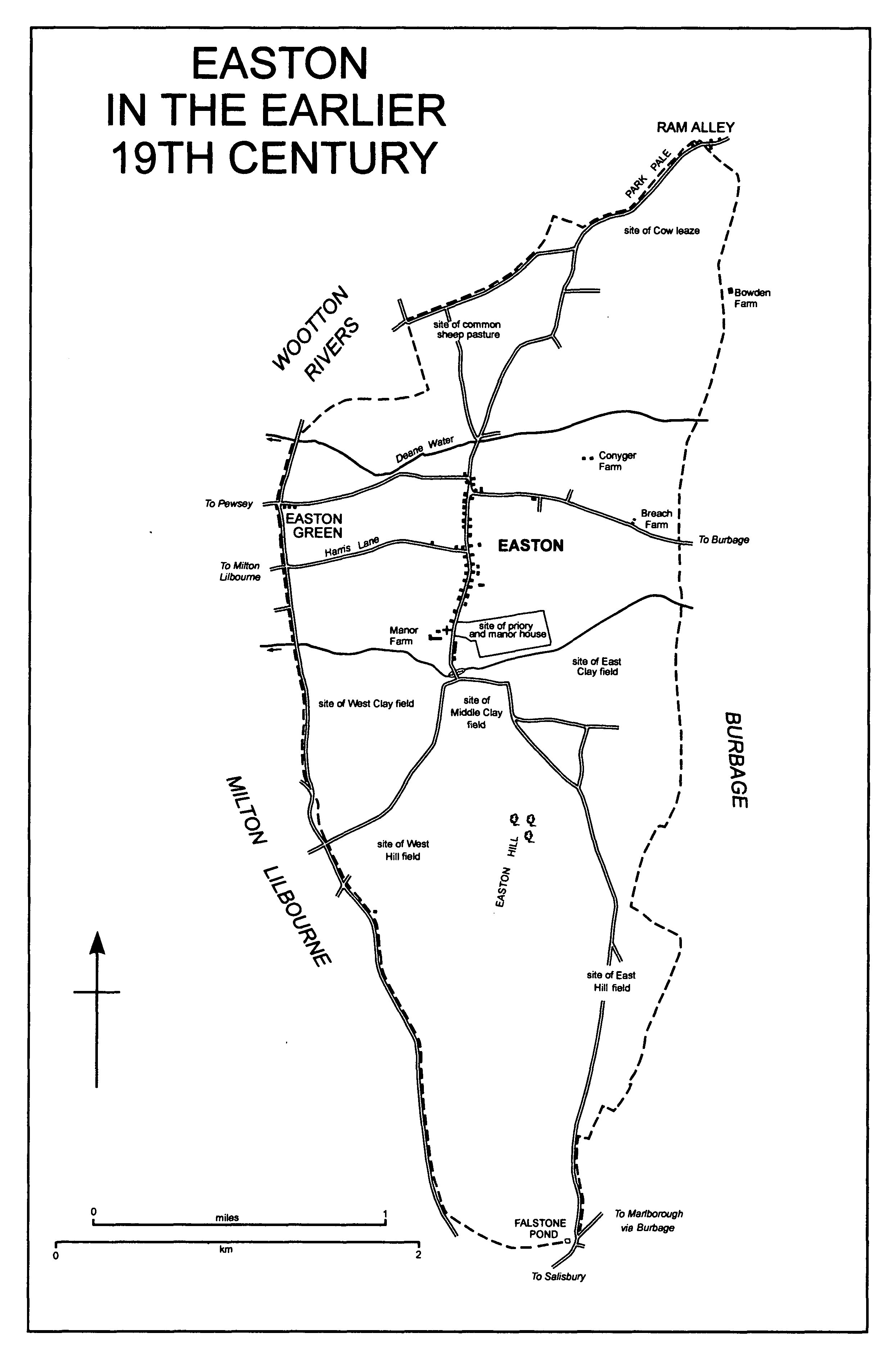
EASTON IN THE EARLIER 19TH CENTURY
Easton village stands 7 km. SSE. of Marlborough near the centre of a parish which measured 900 ha. (2,224 a.) until 1987, (fn. 1) when 3 ha. was transferred to Burbage. (fn. 2) The long and narrow parish lies north-south across the geological outcrops (fn. 3) at the north-east edge of Salisbury Plain, the scarp of which crosses the middle of it east-west. A ridge, Easton Hill, runs south from the scarp and forms a backbone in the south half of the parish.
Easton's name, the east tun, was presumably taken from its relationship to Pewsey, from which it was separated by a middle tun, Milton Lilbourne. (fn. 4) The village is the site of Easton priory, a house of friars of the Trinitarian order, to which the parish church was given, and the office of serving the parish church became a donative. (fn. 5) In 1838 John Ward, the vicar of Great Bedwyn, mistakenly described the donative as royal, (fn. 6) in the 1850s the village began to be called Easton Royal, (fn. 7) and by c. 1860 Ward's description had been accepted as accurate by the Wiltshire antiquarian the Revd. J. E. Jackson. (fn. 8) The suffix was apparently locally popular, and c. 1940 the Wiltshire historian H. C. Brentnall declared that Easton was Easton Royal to all but the official world. (fn. 9) In the late 20th century the local authorities still called the parish Easton, but by then Easton Royal had become the usual name of the village. (fn. 10)
The parish boundary was recited in 1634 and was not changed until 1987. (fn. 11) West of Easton Hill it follows a dry valley for c. 2 km., east of it another dry valley for c. 600 m. Where the two valleys meet at the south-eastern tip of the parish a stone marked the boundary c. 933, (fn. 12) in 1244, (fn. 13) and in 1634, (fn. 14) and it was apparently upright in 1675. (fn. 15) The stone gave its name to Falstone pond which had been dug by 1773 (fn. 16) and lay on the boundary until, in the earlier 20th century, a new pond replaced it. (fn. 17) From 1773 or earlier a road has run the whole length of the boundary on the west. (fn. 18) Around the north part of the parish the boundary follows a dry valley for a short distance and in the extreme north is marked by a road. At the northern tip a pale beside the road separated Easton from Brimslade park in Savernake. (fn. 19) In 1908 the line of the Easton and Wootton Rivers boundary along the road was confirmed. (fn. 20)
The north half of the parish lies entirely on greensand, the south entirely on chalk. Across the north half two head streams of the Christchurch Avon flow from east to west, one south of the village, the other, Deane water, north; the highest land is at 173 m. in the north on the parish boundary, the lowest at 130 m. where the streams leave the parish; the fertile sandy soils are suitable for both arable and pasture, and there were open Welds on them until the 16th century and common pastures until the 17th. In the south half of the parish marly Lower Chalk outcrops between the village and Easton Hill and along the eastern slopes of the hill, and Middle and Upper Chalk outcrop elsewhere; the land rises steeply from the village to the summit of Easton Hill at 240 m., and descends more gently to the old Falstone pond at 159 m. There were open fields on the heavy soil of the Lower Chalk north of the scarp, on similar soil east of the hill, and on lighter soil west of the hill's summit. Easton Hill was for long a rough pasture for sheep. (fn. 21) A clump of trees standing on the summit and said to have been planted after 1747 was the only woodland in the parish in 1773. (fn. 22) About 1880 and in 1996 Easton clump on the summit was a circular plantation of 6 a. (fn. 23)
Easton had 66 poll-tax payers in 1377. (fn. 24) The statement that it had fewer than 10 households in 1428 (fn. 25) is unlikely to be true. In 1801 the population was 391. It increased steadily to reach its peak of 532 in 1841, and declined steadily to 323 in 1881. From 1891 to 1931 it was between 332 and 304. From 256 in 1951 and 1961 it had fallen to 230 by 1981. The parish had 260 inhabitants in 1991. (fn. 26)
The Roman road from Mildenhall to Old Salisbury is likely to have run north-south on Easton Hill as a ridge way, and north of the hill Easton village may stand on or near its line. (fn. 27) In the earlier 13th century the village stood on a road which crossed the parish on the likely line of the Roman road and was probably the main Marlborough-Salisbury road. (fn. 28) The direct course of a Marlborough-Salisbury road through Easton village was blocked in the 16th century when, between Marlborough and Easton, the west part of Savernake forest was inclosed as Savernake great park and Brimslade park, (fn. 29) and in the later 17th century the main Marlborough-Salisbury road, part of a road from Chipping Campden (Glos.), followed a more easterly course through Burbage village. (fn. 30) Across the downland in the south half of the parish in the 18th century roads led from the south end of the village south-east towards Collingbourne Kingston and south-west towards Upavon and West Everleigh (in Everleigh); (fn. 31) tracks and farm roads ran across it in the 19th and 20th centuries, (fn. 32) but no road has been tarmacadamed. In the north half of the parish east-west roads link the village with others standing below the scarp. West of the village Harris Lane, so called in 1759, (fn. 33) may be part of a direct Burbage-Pewsey road via Milton Lilbourne which crossed the middle of Easton village street. In the later 18th century and later Burbage-Pewsey traffic avoided Easton and Milton Lilbourne villages by using a road on higher ground to the north. In 1773 trees stood in the staggered crossing of that road and the north end of Easton village street. (fn. 34) To remove the stagger a short new section of road was built in the mid 20th century. (fn. 35)
The chalk upland in the south part of the parish was a site of prehistoric activity. There is evidence of Iron-Age and Roman settlement on and near the summit of Easton Hill, and there are several barrows further south. (fn. 36)
The east half of the parish was in Savernake forest until 1330. (fn. 37)
Easton is a street village and probably a planned settlement; its name suggests that it was colonized from Pewsey, (fn. 38) and its early church, which probably stood at or near the south end of the street, (fn. 39) may have been built after the farmsteads. The village was planted, or grew, along a road which was probably important in the earlier 13th century and long before. (fn. 40) To relieve poor travellers on the road Easton priory, (fn. 41) under construction in 1234, (fn. 42) was built at the south end of the street on its east side (fn. 43) and 60 paces from the parish church. (fn. 44)
Easton priory was severely damaged by fire in 1493 and almost certainly rebuilt. (fn. 45) In 1536 the prior's house was said to have a defective roof but, presumably c. 40 years old, was probably not demolished when the priory was dissolved in that year. (fn. 46) It is likely to have been the house at Easton lived in by John Barwick, the receiver of Edward Seymour, duke of Somerset (d. 1552), (fn. 47) from 1544 to 1561 or longer, (fn. 48) and to have been demolished soon after a lease of it was surrendered in 1580. (fn. 49) A large manor house, probably built in the late 16th century, stood on the site until c. 1760. (fn. 50) The priory church, which had been the parish church since 1369, was demolished, presumably c. 1591, the year in which a new parish church was built on the west side of the street at the south end. (fn. 51)
A large demesne farm was based at buildings near the new church. (fn. 52) The farmhouse, Manor Farm, has an 18th-century north range of red brick and of two storeys and attics. A range of one storey and attics extending southwards from the west end was destroyed by fire in 1808 (fn. 53) and replaced soon afterwards by a larger south block. In 1996 the farm buildings included a 19th-century open cart shed of timber. A house immediately north of the church and lived in by the vicar of Easton in the later 19th century and early 20th (fn. 54) was apparently timber-framed and built in the 17th century; it was altered and enlarged in brick in the later 19th century. Near the vicar's house and on the east side of the street a new school was built in the later 19th century. (fn. 55)
In the street, which, especially towards its north end, is sunken, there were apparently c. 23 small farmsteads c. 1600, each farmhouse having a close behind it. (fn. 56) It seems that all the farmhouses were replaced. In 1996 several of the 17th century survived and were mostly timberframed and thatched. At the middle of the street on the east side Easton House, a tall red-brick house with a principal west front of three bays, was built in the later 18th century. (fn. 57) Home Farm, of grey brick with dressings of red brick, was built further north on the east side in 1843. (fn. 58) Nearly all of the 71 dwellings in the parish in 1735 (fn. 59) and of the 76 in 1814 were in the street. (fn. 60) In 1996, including a few north of the crossroads, c. 25 timber-framed and thatched houses and cottages of the 17th and 18th centuries stood beside the street, and there were a few pairs of 19th-century cottages. In the 20th century c. 20 houses and bungalows have replaced older buildings or filled spaces on both sides of the street, most at the north end. In the late 18th century the Bleeding Horse was apparently an alehouse in the street; (fn. 61) at the north end a nonconformist chapel was built in the late 19th century (fn. 62) and a village hall c. 1935. (fn. 63) In 1773 there was a pond in the north part of the street on the west side, and there were others either side of a bridge across the stream at the south end. (fn. 64) The northern pond had been filled by 1886; (fn. 65) the southern two apparently dried up in the late 19th century (fn. 66) and were filled in 1955. (fn. 67) In 1975 the whole street was designated a conservation area. (fn. 68)
In Harris Lane a cottage of red brick and thatch was built c. 1800; (fn. 69) it was linked to the village in the 1950s when three pairs of council houses and a pair of old people's bungalows were built between it and the street. (fn. 70) From the crossroads the village was extended eastwards along the Burbage road by the building of five pairs of council houses between 1927 and 1936 (fn. 71) and a pair in 1945; (fn. 72) afterwards 12 private houses were built along the road.
Outside the village a farmstead called Conyger, possibly on the site of an earlier lodge, (fn. 73) had been built by 1735, (fn. 74) and by 1773 Breach Farm had been built south-east of it, possibly on the site of a barn standing in 1735. (fn. 75) Conyger farmstead was greatly enlarged c. 1865; (fn. 76) the farmhouse had been demolished by c. 1970, when a bungalow was built at the farmstead. (fn. 77) Extensive farm buildings remained on the site in 1996. The site of Breach Farm is marked by a trio of mid 19th-century thatched cottages. West of the village, at a site called Easton Green in 1773, (fn. 78) a house was held by John Gammon in the earlier 17th century (fn. 79) and the Gammon of Bacon was an inn on the south side of the Pewsey road from 1736 or earlier. (fn. 80) Between 1848 and 1855 it was replaced by a new inn, the Bruce's Arms, (fn. 81) built on the opposite side of the road and open in 1996. On the south side of the road a pair of cottages was apparently altered in the late 19th century. (fn. 82) In the northern tip of the parish two cottages standing in 1634 and three in 1721-2 were part of Ram Alley, (fn. 83) a small settlement mainly in Burbage. (fn. 84) A pair of cottages was replaced by a house built in 1940; (fn. 85) the cottage which survives is timber-framed, thatched, and possibly early 18th-century. On the downs in the south of the parish farm buildings were erected west of Easton Hill between 1773 and 1814 and east between 1814 and 1867; (fn. 86) both groups were in use in 1996.
Michael Clark of Easton was said in 1649 to be a delinquent Royalist. (fn. 87) John Wildman, a republican, was arrested at Easton in 1655 while dictating a declaration against Cromwell. (fn. 88)
MANORS AND OTHER ESTATES.
Easton may have been part of a large estate called Wootton which belonged to the king in 1086. (fn. 89) In the mid 12th century it belonged to John FitzGilbert (d. 1165), the king's marshal from c. 1130, who gave half of it to Bradenstoke priory. (fn. 90) The other half probably passed in turn to John's sons Gilbert FitzJohn (d. 1165-6) and John, and between 1174 and 1186 John, as John the marshal, gave it to the bishop of Hereford in an exchange. (fn. 91) Between c. 1196 and 1198 the bishop granted that half to Adam of Easton at fee farm for a rent of £10. (fn. 92) Adam's heir was his son Stephen of Tisbury, rector of Easton and of Tisbury, archdeacon of Wiltshire from c. 1226, and the founder of Easton priory, on whose death in 1246 (fn. 93) the half passed in moieties to his nephew Geoffrey Sturmy and niece Felice, the wife of Sir William Druce. (fn. 94)
Felice Druce's quarter of Easton, later called EASTON DRUCE or EASTON PRIORY manor, was settled on her son Geoffrey (fl. 1275) in tail with remainder to his brother Hugh. (fn. 95) In 1321 Hugh's son Robert conveyed the estate to his cousin Robert Druce (fn. 96) (d. 1324 × 1328), (fn. 97) and from that Robert it passed to his son Sir John. (fn. 98) By 1344 it had been acquired by Walter Kingsettle (fn. 99) and his wife Lettice. In 1348-9 it was bought from the Kingsettles by Robert of Burbage, rector of Compton Chamberlayne, who under a licence of 1349 gave it to Easton priory: in exchange the priory was to assign two of its brethren to celebrate mass for Robert and his nominees and from Robert's death to give 1s. a year to each of seven new brethren to be received into the priory. (fn. 100) The estate belonged to the priory until 1536, when the priory was dissolved and the estate was granted to Sir Edward Seymour, Viscount Beauchamp (fn. 101) (cr. earl of Hertford 1537, duke of Somerset 1547), its patron and a descendant of its founder. Seymour held it until his execution and attainder in 1552, (fn. 102) when by Act it passed to his son Sir Edward (fn. 103) (a minor until 1558, cr. earl of Hertford 1559, d. 1621). (fn. 104)
At his death c. 1254 Geoffrey Sturmy's quarter of Easton, later called EASTON WARREN manor, descended to his son Henry (d. c. 1296). (fn. 105) It belonged to Philip Sturmy in 1324 (fn. 106) and 1347 (fn. 107) and to Henry Sturmy of Easton in 1349. (fn. 108) It was held by Richard Warren in 1428 (fn. 109) and 1454, (fn. 110) and descended in the Warren family with Fyfield manor in Milton Lilbourne (fn. 111) until, between 1545 and 1550, the estate was bought from John Warren by Edward, earl of Hertford and from 1547 duke of Somerset. (fn. 112) On Somerset's attainder it was forfeited to the Crown, and in 1553 it was assigned by Act to his son Sir Edward. (fn. 113)
Bradenstoke priory kept its half of Easton until the Dissolution. (fn. 114) As EASTON BRADENSTOKE manor it was received by Edward, earl of Hertford, in 1541 in an exchange of land with the king. (fn. 115) Like Easton Warren manor it was forfeited to the Crown in 1552 and assigned to Sir Edward Seymour in 1553. (fn. 116)
From c. 1237 the RECTORY estate, consisting of 26 a., feeding rights for 40 sheep and 1 ram, and the tithes of the whole parish except those of corn, hay, and cheese from Bradenstoke priory's demesne land, belonged to Easton priory. (fn. 117) It passed with Easton Druce manor from c. 1349, and from 1553 all the tithes belonged to the owner of the land from which they arose. (fn. 118)
From c. 1237 the tithes excepted from the Rectory estate belonged to Bradenstoke priory and later owners of the land from which they arose. (fn. 119)
From 1553 to 1929 the whole parish, including all tithes from it, descended in the Seymour, Bruce, Brudenell, and Brudenell-Bruce families with Tottenham Lodge and Tottenham House in Great Bedwyn. (fn. 120) Edward, earl of Hertford, was living at Easton in 1581, (fn. 121) and a new manor house was probably built about then on the site of Easton priory. From c. 1600 Lord Hertford also lived in a house at Amesbury, (fn. 122) but the manor house at Easton was kept in hand and lived in by him until 1621 (fn. 123) and by his relatives until it was leased (fn. 124) in 1675. From 1693 the lease was held by Sir Edward Seymour, Bt. (d. 1740), who lived at Easton. (fn. 125) The house was demolished c. 1760. (fn. 126)
About 1929 George Brudenell-Bruce, marquess of Ailesbury, sold Manor farm, 754 a. in the west part of the parish, to J. S. Haines (d. 1937), from whom it descended with Lower farm, Milton Lilbourne, to his son J. S. Haines. Of Manor farm 130 a. passed with Lower farm and belonged to Mr. G. E. R. Osborne in 1996, (fn. 127) and 197 a. was sold to W. R. Curnick and in 1996 belonged to his son Mr. T. W. Curnick as part of Southgrove farm, Burbage. (fn. 128) The reduced Manor farm was sold by Haines to Robert de Pass in 1954, and in 1996, then 486 a., it belonged to de Pass's son Mr. M. A. R. de Pass. (fn. 129) In 1929 Lord Ailesbury sold Easton farm, 681 a. in the east part of the parish, to J. T. Cooper, whose grandson Mr. S. P. Cooper owned it in 1996. (fn. 130) Of land in the north part of the parish sold by Lord Ailesbury c. 1929 Conyger farm had 345 a. in 1971; the farm was bought then by Mr. J. C. Brook, the owner in 1996. (fn. 131) In 1950 Lord Ailesbury sold c. 150 a. at the north end of the parish to the Crown, which in 1996 owned it as part of Bowden farm based in Burbage. (fn. 132)
The bishop of Hereford kept the fee-farm rent of £10 until it was given to Elizabeth I in an exchange. Between 1651 (fn. 133) and 1672 it was sold by trustees appointed by parliament, and in 1770 it was bought from William Morehead by Thomas Bruce, Lord Bruce, (fn. 134) the owner of Easton Druce and Easton Warren manors. (fn. 135)
ECONOMIC HISTORY.
The lands of the three manors into which Easton was divided in the 12th and 13th centuries (fn. 136) were intermingled throughout the parish; (fn. 137) each manor consisted of demesne and customary land, (fn. 138) and later evidence suggests that the demesne in the parish was bisected in the mid 12th century and that one of the halves was bisected c. 1246. (fn. 139) The arable lay in open fields and c. 1200 there was apparently common pasture for cattle and pigs. (fn. 140) In the Middle Ages there were probably only two open fields, East and West, running north- south across the geological outcrops east and west of the village. Of all three manors both the demesne and the customary holdings apparently included arable in all parts of the fields, and they probably shared a common pasture for cattle in the north part of the parish and, on Easton Hill between the open fields, one for sheep in the south. (fn. 141)
By the 16th century some demesne land had been inclosed: Bowden close, 60 a. in the earlier 16th century (fn. 142) and presumably in the north-east corner of the parish, (fn. 143) had been inclosed by the mid 13th century, (fn. 144) In mead had been inclosed by the earlier 14th century, (fn. 145) and Easton Druce manor included other several pastures in the earlier 16th century. Also by the 16th century each open field had been divided into a Hill field, one on either side of Easton Hill, a Clay field, both on the Lower Chalk, and, one on either side of the village, a Sand field on the greensand; all but a small part of Easton Hill had been reserved for demesne sheep, and all the uninclosed pasture in the north for the copyholders' sheep and cattle. (fn. 146) At the Dissolution inclosed demesne of Easton Druce manor was held by Easton priory in hand, a demesne farm including a nominal 208 a. in the open fields and pasture for 240 sheep was held on lease, and the customary land of the manor was in eight copyholds which had small areas of meadow and inclosed pasture, a nominal 186 a. in the open fields, and feeding in common for 455 sheep and for cattle. (fn. 147) Bradenstoke priory apparently kept a directly managed flock at Easton in 1348-9, (fn. 148) and may have kept in hand the demesne pasture rights of Easton Bradenstoke manor after it had leased the demesne land. (fn. 149)
In the later 16th century the two fields on the greensand were inclosed and c. 130 a. of closes, called East Sands, West Sands, East Several, and West Several and mostly of 2-10 a., was added to copyholds. The copyholders' sheep stint, 80 to each yardland, was not reduced and, although it was customary to feed the demesne sheep on the open fields for only six days, most of the new closes were laid to grass. By 1579 the common pasture in the north part of the parish had been divided by hedges into two common pastures, one of c. 138 a. for sheep, and Cow leaze, c. 215 a. (fn. 150) The three demesne farms were merged (fn. 151) and inclosures east and north-east of the village, including some in Burbage parish, were held with the house standing on the site of the priory. A 50-a. rabbit warren on Bat field and Old land, presumably former arable, apparently lay northeast of the village, (fn. 152) and the Breach, a several demesne pasture, lay east of the warren. (fn. 153) In 1581 c. 8 a. of the downland open fields was inclosed as penning for sheep on the demesne. (fn. 154)
About 1600 the composite demesne farm, probably based partly in the buildings on the demesne of Easton Bradenstoke manor, formerly called the Black farm, may have been in hand. Of the three manors there were c. 23 copyholds averaging c. 30 a. They included c. 250 a. near the village and in closes of 2-12 a., rights to feed 1,832 sheep, and nominally c. 450 a. in the open fields. (fn. 155)
In the early 17th century, probably c. 1610, the sheep common and Cow leaze were inclosed and c. 54 closes were added to copyholds; another common pasture, West ridge, 37 a., was also inclosed. (fn. 156) In 1608, when it measured 150 a. and a lodge stood on it, the warren was leased for a rent of 500 pairs of rabbits. (fn. 157) In 1618 the Breach, 60 a., and part of In mead, a demesne meadow, were leased; (fn. 158) by 1634 the Breach had been divided into 3 closes. The preservation of rabbits had apparently ceased by 1625, when the warren was leased as 6 closes; also in 1625 demesne pastures called Longland and Oatleazes, a total of 42 a., were leased as 19 closes. In 1634 the demesne remaining in hand was 59 a. of meadow, 60 a. of lowland pasture, the rough pasture on Easton Hill, and nominally c. 340 a. in the open fields. (fn. 159) That farm, later Manor farm, was leased in 1637. (fn. 160)
In the early 18th century in the south half of the parish there were five open fields in which lay 628 a. of arable in 801 parcels with c. 48 a. of lynchets: on the downs to the south East Hill field measured 210 a., West Hill field 113 a.; to the north East Clay field measured 112 a., Middle Clay 100 a., and West Clay 93 a. Between East Hill field and West Hill field lay the farm down, 387 a., and c. 30 a. of tenantry down. The two downland fields were ploughed in alternate years; each of the three lowland fields was ploughed two years in three. Mainly in the north half of the parish there was 1,024 a. in 365 closes; c. 845 a. of that land was arable. Among the closes 24 called West Several included c. 60 a., 17 called East Several c. 35 a., 13 called Oatleaze c. 47 a., and 5 called Farm Oatleaze c. 55 a. On the former warren there were 18 closes called Conyger, c. 47 a., in one of which stood a farmhouse; the Breach, c. 54 a., had been divided into 12 closes, in one of which stood a barn. Manor farm, 782 a., included 264 a. of the open fields, 68 a. of inclosed arable, 44 a. of meadow, the 12-a. penning, and the farm down. There were c. 26 copyholds and leaseholds, varying from 82 a. to c. 15 a.; nearly all had more land in closes than in the open fields and most included feeding rights for sheep. Some of the holdings may have been worked with others but most farms seem to have been small, and all the farm buildings except those of Conyger farm and Breach farm stood in the village street. (fn. 161)
In 1773 the open fields were inclosed by private agreement. West Hill field, West Clay field, and part of Middle Clay field, a total of 305 a., were allotted for Manor farm, to which three small former copyholds had been added. The lands to the east were allotted as fields of 1-31 a. to the other holdings, of which there were c. 20. To compensate those holdings for the loss of feeding on the arable of Manor farm 130 a. of the farm's down was allotted for their use in common. (fn. 162) That and c. 22 a. of other downland apparently remained in common use until the mid 19th century. (fn. 163) In the late 18th century holdings were being enlarged and converted from lifehold to rack rent. By 1784 a farm had grown to 268 a., and four to 100-150 a., as holdings were agglomerated. (fn. 164)
In 1814 there was in the parish c. 1,500 a. of arable, 139 a. of meadow, 57 a. of permanent lowland pasture, and 461 a. of downland pasture. Manor farm measured 773 a. and included a farmyard on the former West Hill field. There were six other farms, of which the largest measured 236 a. and the smallest 77 a., and seven smaller holdings. All except Conyger farm, 77 a., were based in the street, and their lands were intermixed and inconvenient to use. (fn. 165) By 1867, when Manor farm measured 712 a., several farms had been merged as Easton farm, 860 a. including 299 a. in Burbage. Between 1867, when all eight farms based in the parish were mainly arable, (fn. 166) and 1929 much land was laid to grass, and in the earlier 20th century the downland pasture was used as gallops. In 1929 Manor, 754 a., and Easton, 681 a., were mixed farms; the others, of 313 a., 112 a., 55 a., and 38 a., were mainly dairy farms. (fn. 167)
At the north end of the parish c. 150 a. was probably worked from Burbage as part of Bowden farm in the 19th century, as it was from 1910 or earlier and in 1996. (fn. 168) Manor farm was worked with Lower farm, Milton Lilbourne, from c. 1905 to 1954, (fn. 169) since when it has been a separate farm with land north of Easton Hill and west of the village; in 1996 it was a mixed farm of 486 a. (fn. 170) Most of the land in the south part of the parish taken from Manor farm (fn. 171) lay in the later 20th century as arable in large fields worked from Lawn Farm, Milton Lilbourne, and Southgrove Farm, Burbage. (fn. 172) In 1996 Easton farm, still 681 a., was an arable and beef farm. (fn. 173) In 1971 Conyger farm, 345 a., lay entirely on greensand in the north part of the parish. In the 1970s it was an arable, beef, and sheep farm; thereafter and in 1996, when it measured 381 a., it was an arable and sheep farm. (fn. 174)
A tailor and a weaver lived at Easton in 1352; (fn. 175) stone for building was quarried in the 16th and 17th centuries. (fn. 176) There was a malthouse in the village in the 18th century (fn. 177) and there were two in the earlier 19th. (fn. 178)
LOCAL GOVERNMENT.
By 1289 Bradenstoke priory had made good its claim to enforce the assize of bread and of ale at Easton; (fn. 179) it held a view of frankpledge there twice a year in the mid 14th century (fn. 180) and apparently until the Dissolution. (fn. 181) The records of five meetings of the court of Easton Warren manor between 1263 and 1266 survive; misuse of pasture with sheep was reported in 1266 but little other business was done. (fn. 182) The records of two meetings of the court of Easton Druce manor in 1348-9 survive; the court heard pleas, recorded the death of tenants, witnessed admittances, and punished the misuse of pasture. (fn. 183)
Between 1541 and 1550 one court, called a view of frankpledge and manor court, was held for Easton Druce and Easton Bradenstoke manors, then in single ownership. A tithingman was chosen and the making of stocks required, but the court did little other leet business and dealt mainly with the transfer of copyholds, breaches of the rules of common husbandry, and the maintenance of hedges, ditches, and buildings. (fn. 184) From 1553 the three manors in the parish were in single ownership, (fn. 185) and until c. 1580 a single court and, once a year, a single view were held for them all. The court, at which a single homage was sworn, acted as it had in the 1540s, but the view began to punish statutory offences such as the playing of unlawful games. (fn. 186)
From c. 1580 a separate court was held for each of the three manors, that for Easton Bradenstoke incorporating the view of frankpledge. Except for special meetings of the courts baron, the three courts met on the same day as each other and usually once a year, jurisdiction over the whole parish was exercised by the view, and until c. 1600 joint presentments were sometimes made by the three homages and sometimes by the jury and the three homages; (fn. 187) it was sometimes expressly stated that orders made by any one of the courts were to apply to the whole parish. (fn. 188)
At the view matters presented under leet jurisdiction in the late 16th century and early 17th included public nuisances, the condition of the stocks, affray, the playing of unlawful games, failure to practise archery, keep a rook net, wear statutory caps, and repair roads, and the unlawful building of cottages, carrying of a fowling piece, and accepting of inmates; (fn. 189) in the 1590s removal orders were made. (fn. 190) Very little was presented under leet jurisdiction after c. 1625. (fn. 191)
At the three manor courts private pleas were heard until the 1590s. The courts continued to be concerned with the definition and observance of agrarian custom and the condition of gates, boundaries, hedges, ditches, and buildings, but from the later 17th century presentments relating to such matters became fewer and conveyancing became the principal business. From c. 1730 to c. 1770 stereotyped presentments of some customs were recorded, but from c. 1770 the courts dealt only with tenurial business. (fn. 192)
The parish spent £103 on poor relief in 1775-6, an average of £117 a year in the early 1780s. It apparently had a workhouse which had been demolished by 1798. In 1802-3, when the poor rate was high and all relief was outdoor, the parish spent £304: 24 adults and 94 children were relieved regularly, 8 people occasionally. (fn. 193) Expenditure had risen to £701 by 1812-13, when 40 adults were relieved regularly and 25 occasionally; by 1814-15 it had been reduced to £294 and the numbers to 22 and 15 respectively. (fn. 194) A tenement which the parish had built housed 7 paupers in 1814. (fn. 195) From 1814-15 to 1833-4 expenditure on poor relief averaged £389 a year. At £563 it was highest in 1818-19, at £249 lowest in 1815-16. (fn. 196) The parish joined Pewsey poor-law union in 1835 (fn. 197) and became part of Kennet district in 1974. (fn. 198)
CHURCH.
In 1086 on the king's large estate called Wootton there were two churches belonging to the abbey of Mont St. Michel (Manche), one of which may have stood at Easton. (fn. 199) Later Easton church may have belonged to the abbey of la Trinité du Mont, Rouen (Seine-Maritime), until, between 1193 and 1198, that abbey presented Adam of Easton's son Stephen, later Stephen of Tisbury (d. 1246), as rector. (fn. 200) Between 1199 and 1207 William Marshal, earl of Pembroke, whose father John FitzGilbert, the king's marshal, had granted half of Easton to Bradenstoke priory, incompatibly granted the church to the priory, and the priory prepared to present a rival rector. (fn. 201) Stephen's right to the church was examined and confirmed between 1218 and 1222, (fn. 202) but the patronage remained in dispute. Stephen claimed it by a grant of his patron, in the 1240s called the abbey of SainteCathérine-du-Mont, which claimed it by a grant of a former marshal of England: Bradenstoke priory claimed it by grant of William, earl of Pembroke. The dispute was referred to the bishop of Salisbury for arbitration, and by 1237 it had been decided that Bradenstoke priory should have all the tithes of corn, hay, and cheese from its demesne land at Easton, that all other tithes arising at Easton should be kept by Easton church, and that the church should be given to the religious house founded at Easton by Stephen c. 1234. The decision was ratified in 1246. (fn. 203) From then the duty of serving the church was presumably given by the prior of Easton to a brother of the priory, (fn. 204) and from 1369 the parishioners worshipped in the priory church. (fn. 205)
The living remained a donative and from the dissolution of Easton priory in 1536 was held by curates, from 1868 by vicars, all nominated by the owner of the Rectory estate. (fn. 206) The parish was under the jurisdiction of the ordinary in the 16th and 17th centuries, (fn. 207) in the late 18th century and early 19th claimed, apparently successfully, to be exempt from it and under the peculiar jurisdiction of the owner of the Rectory estate, (fn. 208) and again accepted the bishop's jurisdiction c. 1847. (fn. 209) In 1929 the vicarage was united to Milton Lilbourne vicarage, and in 1991 the united benefice was united to Pewsey rectory and Wootton Rivers rectory. George Brudenell-Bruce, marquess of Ailesbury, the owner of the Rectory estate, shared the patronage of the united benefice formed in 1929; in 1953 he transferred his share to the bishop of Salisbury, who became a member of the board of patronage for the united benefice formed in 1991. (fn. 210)
It seems that between the 1190s and the 1230s the rector took all tithes from the whole parish and held 26 a. in the open fields with feeding for sheep. (fn. 211) After the church was appropriated the minister had neither tithe nor glebe, (fn. 212) although in the earlier 17th century the owner of the Rectory estate allowed the curate to take some tithes. (fn. 213) In 1537 the curate's salary was £5, (fn. 214) in 1675 £30, (fn. 215) and in 1822 £60. (fn. 216) In 1928-9, the last year in which the owner of the Rectory estate paid it, the vicar's salary was £200. (fn. 217) In 1987 a house in the village was bought as a parsonage house. (fn. 218)
The foundation of a chantry in the parish church was confirmed in 1326: under an agreement of 1322 Easton priory, in exchange for land given to it by Robert Druce, the lord of Easton Druce manor, was to celebrate mass at an altar in honour of St. John the Baptist in a north chapel which Robert had added to the parish church by 1322. To maintain the chapel and provide lights in it Robert gave 12s. a year and a flock of 200 sheep to the parish church. (fn. 219)
About 1532 Henry Brian, the last prior of Easton, was said to have refused to allow services to be held for parishioners for more than two years, but in 1536-7, after the dissolution of the priory, he was himself serving the parish church as curate. (fn. 220) The parishioners complained in 1553 that quarterly sermons were not preached and an appropriate communion table had not been provided, (fn. 221) and in 1556 that church property had not been returned and prescribed ornaments were lacking. (fn. 222) Services were presumably adequate in 1634, when some parishioners of Burbage preferred them to those in their own church. (fn. 223) In 1662 the curate was found to have slandered Henrietta, queen of Charles I. (fn. 224) Joseph Wall, curate 1693-1714 or longer, Charles Curtis, curate from 1766 to c. 1774, and John Swain, curate from c. 1776 to c. 1799, were each vicar of Milton Lilbourne, and Swain was also curate of Collingbourne Kingston. (fn. 225) David Llewellyn, curate 1839-68, probably lived in a house near the church. In 1864 he held a morning and an evening service each Sunday, both with a sermon, and held services on Christmas day, Ash Wednesday, the Wednesday in Holy Week, and Good Friday; he held communion four times a year with c. 20 communicants and catechized in the schoolroom. (fn. 226) From 1971 to 1986 the united benefice was held in plurality with Wootton Rivers rectory. (fn. 227)
The parish church, called St. Mary's in 1323, (fn. 228) was enlarged by the addition of the north chapel c. 1322. (fn. 229) In 1369 it was demolished, permission was given for its materials to be used to enlarge the priory church, and the parishioners were licensed to use the priory church as the parish church. (fn. 230) The church was badly damaged or destroyed in the fire of 1493 (fn. 231) and apparently repaired or rebuilt. In 1536, 1553, and 1556 it was reported to be in poor condition. (fn. 232) In 1590 a monument to the owner's grandfather, Sir John Seymour (d. 1536), was taken from the church to Great Bedwyn church; (fn. 233) a new parish church at Easton was built in 1591, (fn. 234) and the old priory church was demolished presumably about then. The dedication of the new church, called HOLY TRINITY in 1763, (fn. 235) repeats that of the priory. (fn. 236) The church was built of rubble, much of it re-used ashlar, and consists of an undivided sanctuary and nave, with a south tower incorporating a vestry and with a north porch. The body of the church and the porch survive from 1591. A wall of a, presumably west, tower fell in or shortly before 1668. (fn. 237) By 1806 the tower had been taken down and replaced by a bell turret built above the west bay of the nave. (fn. 238) In 1852-3 the bell turret was removed, the nave was extended westwards by one bay, the south tower was built, and the church was generally restored. (fn. 239)
In 1553 a chalice of 7½ oz. was kept by the parish and 11½ oz. of silver was taken for the king. In 1891 and 1995 the parish had a chalice hallmarked for 1682 and a paten given in 1728. (fn. 240)
In 1536 the bells in the priory church belonged to the parish; (fn. 241) there were three in 1553. The bells hung in the new church in 1591, presumably the same three, were replaced by a tenor cast by John Wallis in 1607, a bell cast by John Danton in 1633, and a treble cast by Robert Wells in 1764. (fn. 242) The treble was removed from the church in 1984 and not replaced; the other two bells hung in the church in 1995. (fn. 243)
The register was probably stolen when the church was robbed c. 1550, and in 1553 was not being kept. (fn. 244) Registers from 1580 are extant and complete, entries for 1580-1603 being transcripts. (fn. 245)
NONCONFORMITY.
A papist may have lived at Easton in 1678 and 1681, (fn. 246) and members of the Batt family were Roman Catholics there in the later 18th century. (fn. 247)
Two protestant nonconformists lived at Easton in 1676. (fn. 248) A Methodist meeting house was described as a dwelling house in 1835, when it was certified, (fn. 249) and later as a chapel built in 1834. On Census Sunday in 1851 three meetings with an average attendance of 90 were held in it. (fn. 250) The building was in ruins in 1862, when the meeting, still well attended, was held in a converted farm building. (fn. 251) A new chapel, small and of red brick, was built in 1898-9. (fn. 252) It was closed in the mid 1950s. (fn. 253)
EDUCATION.
In 1814 a school held in a large room in a house was possibly a boarding school with c. 40 pupils. (fn. 254) The parish received £8 a year from a charitable gift to support a school, (fn. 255) but it is not clear how it spent the money in 1814. The endowment probably supported the day school for 24 children kept in 1818 (fn. 256) and a small school held in 1831, (fn. 257) but nothing more is known of it. In 1833 there was a National school with 20 pupils and an infants' school with 12. (fn. 258) A single school had 72 pupils in 1846-7, (fn. 259) 60-70 in 1859, (fn. 260) and 46 in 1871. (fn. 261) A new school was built in 1871: in the 1870s its pupils were aged from 2 to 11 and average attendance was c. 55. (fn. 262) Average attendance was 59 in 1902-3, (fn. 263) 51 in 1926-7, and 33 in 1937-8. (fn. 264) In 1995 there were 37 pupils on the roll. (fn. 265)
CHARITIES FOR THE POOR.
William Francis (d. 1805) by will gave the interest from £500 to be distributed at Christmas among the industrious poor of the parish. From c. 1807 to c. 1822 money was distributed, from c. 1822 to c. 1829 coal, and from c. 1829 to c. 1833 sometimes coal and sometimes blankets. The charity's income was £22. J. T. Lawes (d. 1828) by will gave the interest from £100 to the industrious Anglican poor of the parish, gifts to be made with those of Francis's charity; the income was £4. In 1900 the income of the two charities was £23, and 2 cwt. of coal was given to each of 154 people. (fn. 266) From 1917 to the 1930s beneficiaries of Francis's charity usually received coal, those of Lawes's usually clothing. After the Second World War, when the income of the two charities was c. £24, most gifts were of money. In 1986 the charities were merged, in 1993 the capital was given away in sums of £25, and in 1994 the combined charity ceased to exist. (fn. 267)