A History of the County of Wiltshire: Volume 16, Kinwardstone Hundred. Originally published by Victoria County History, London, 1999.
This free content was digitised by double rekeying. All rights reserved.
'Pewsey', in A History of the County of Wiltshire: Volume 16, Kinwardstone Hundred, (London, 1999) pp. 181-207. British History Online https://www.british-history.ac.uk/vch/wilts/vol16/pp181-207 [accessed 23 April 2024]
In this section
PEWSEY
Pewsey parish stretches from the Marlborough Downs to Salisbury Plain across the valley to which it gives a name. (fn. 1) It measured 1,935 ha. (4,782 a.) until 1987, when small areas were transferred to Manningford, Milton Lilbourne, and Savernake, and from Milton Lilbourne and Wilcot, and it was reduced to 1,909 ha. (fn. 2) In addition to Pewsey village the parish included villages and hamlets called Kepnal, East Sharcott, West Sharcott, Southcott, and West Wick.
About 940 an estate called Pewsey had a boundary apparently approximate to what became the parish boundary, (fn. 3) and later the villages and hamlets all stood on the land of Pewsey manor. (fn. 4) Pewsey village presumably originated where the church, probably the rectory house, and the large demesne farmstead of the manor stood close together on rising ground. (fn. 5) By contrast Kepnal, East Sharcott, and Southcott are all street villages, and they were almost certainly colonized from Pewsey, Southcott probably before Kepnal and East Sharcott. (fn. 6) To the east Milton Lilbourne and Easton apparently took their names from their relationship to Pewsey village, (fn. 7) but there is no other evidence that they were subsidiary settlements of it.
At the north end of the parish the eastern boundary of the estate called Pewsey ran c. 940 along the western ditch of an Iron-Age hill fort on Martinsell Hill, (fn. 8) thus excluding the hill fort from the estate; later the parish embraced it, the parish's eastern boundary following the hill fort's eastern ditch. (fn. 9) West of the hill fort the parish boundary follows a prehistoric ditch, and south of the ditch it was set in 1280 to follow the contours at the foot of a west facing scarp. (fn. 10) South of Martinsell Hill, on the east the north part of the parish boundary follows the bottom of a north-south dry valley for 1.5 km.; also straight, the south part of the boundary ignored relief. On the west the boundary west of Pewsey village follows a road which may have been ancient; (fn. 11) on the southern downland for c. 1 km. it follows the contours and what is probably a lynchet, and in several places it crosses the contours at right angles. On the south, two barrows stood on Pewsey's boundary with Everleigh c. 940; (fn. 12) the boundary was uncertain in 1290 and, possibly as a result of a decision of a commission then appointed to settle it, (fn. 13) later ran north of the barrows.

PEWSEY 1839
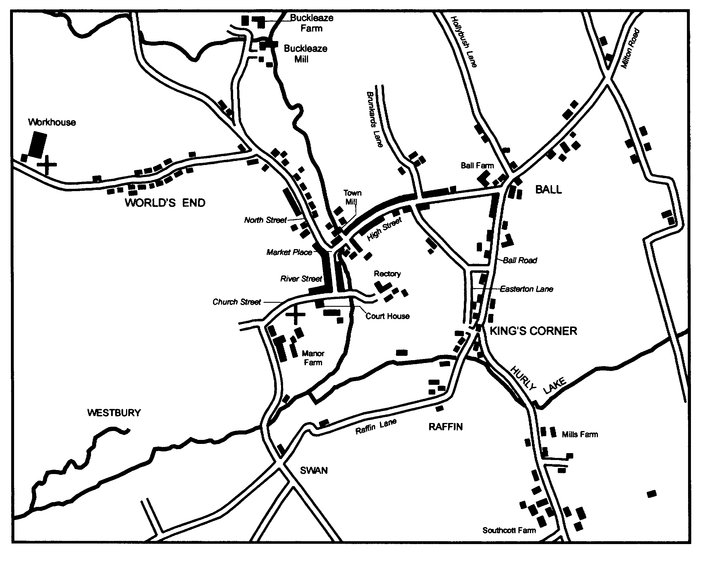
Pewsey village and nearby settlements
Chalk outcrops at both ends of the parish, Upper Greensand extensively in the centre. The northern downland, part of the Marlborough Downs, consists of the flat summit of Martinsell Hill, which reaches 289 m., its steep south and west sides, and a triangle of gently sloping land north of it; the summit and much of the triangle are overlain by clay-with-flints. The more extensive southern downland, part of the northern edge of Salisbury Plain, consists of the northfacing scarp and of ridges and dry valleys south of it. The highest point is at 221 m. The centre of the parish is drained from north-east to south-west by the Avon, one of two principal head streams of the Christchurch Avon, and from the north-west by Ford brook, which joins the Avon north of Pewsey village; a tributary which flows westwards through marshy ground called Hurly lake south-east of Pewsey village joins the Avon south of the village, and a tributary which flows south-eastwards through marshy ground west of Pewsey village joins the Avon south of East Sharcott village. The Avon leaves the parish at 102 m. Alluvium has been deposited by the Avon, Ford brook, and the stream flowing near East Sharcott village, and there are deposits of gravel on the south bank of the Avon west of Pewsey village, at Hurly lake, and in several places between the streams; brickearth has been deposited between Pewsey and Kepnal. (fn. 14)
Open fields lay on the mainly flat land, where greensand and marly Lower Chalk outcrop, between the principal villages of the parish and the scarp of Salisbury Plain; a much smaller area of open fields lay mainly on the Lower Chalk south of Martinsell Hill. In the Middle Ages the greensand between the two areas of open fields was mostly pasture; between the 17th century and the 19th most of it was converted to arable. At both ends of the parish most of the downland was rough pasture for sheep; much of it was ploughed in the late 18th century or early 19th. (fn. 15)
Woodland at Pewsey was said to cover an area only 3 furlongs by ½ furlong in 1086, (fn. 16) and the parish has never been well wooded. In the triangle at the north end Withy copse was standing in 1300 (fn. 17) and was accounted 11 a. c. 1700. (fn. 18) In 1767 Inlands grove north of Pewsey village was woodland accounted 20 a. and there was 10 a. of wood near the western parish boundary at Hare Street, (fn. 19) and by 1773 a copse had been planted beside Sunnyhill Lane north of Pewsey village. (fn. 20) In 1838 there was 70 a. of woodland in the parish. Withy copse then measured 28 a., there was 14 a. of woodland on the hill fort on Martinsell Hill, most of it planted in the period 1800-5, and most of the other woodland stood as copses of 5-12 a. in the north half of the parish. (fn. 21) By 1886 a few of those copses had been removed and additional trees planted on the west-facing scarp west of Martinsell Hill. (fn. 22) The distribution and amount of woodland changed little between 1886 and the late 20th century, when apparently less than 100 a. of the parish was wooded. (fn. 23)
The parish had 267 poll-tax payers in 1377, (fn. 24) apparently c. 648 inhabitants in 1676. (fn. 25) The population, 1,179 in 1801, increased rapidly in the earlier 19th century. It stood at 1,588 in 1831, 1,825 in 1841, when 69 people lived in the union workhouse built in the parish in 1836, and 1,921 in 1851, when 122 people lived in the workhouse. It was 2,027 in 1861, when labourers building a railway were temporarily resident in the parish. From 1,930 in 1871 it declined steadily to reach 1,574 in 1931. The conversion of the workhouse to a colony of mental defectives in the 1930s and the building of many new houses in the parish caused increases in the population, which stood at 2,351 in 1951, 2,579 in 1981, and, after the boundary changes of 1987, 2,831 in 1991. (fn. 26)
No road across Pewsey parish was turnpiked (fn. 27) and none had more than local importance until the 20th century. Pewsey village stands on a road which, east of it, links villages below the northern scarp of Salisbury Plain; it may first have linked the villages from centre to centre, but in the later 18th century and later bypassed each one at its north end and, as Milton Road, approached Pewsey from the north-east. (fn. 28) As Salisbury Road it leaves Pewsey towards the south-west and joins the roads linking the villages in the Avon valley between Upavon and Salisbury. From the north Pewsey was reached from Marlborough by a road across Martinsell Hill which approached the village via Milton Road, and to the south was linked to Salisbury by a road leading from the village across the downs to join the main downland Marlborough- Salisbury road at Everleigh. The road across Martinsell Hill went out of use in the 19th century; alternative routes from Marlborough avoiding that hill ran to the east via Clench in Milton Lilbourne parish and to the west via Oare in Wilcot parish. The Marlborough-Oare road was part of a Marlborough-Salisbury road which led via Upavon and the Avon valley and bypassed Pewsey; Hare Street, which marks the parish boundary on the west, was part of its course. (fn. 29) South of Upavon the road was turnpiked in 1840, (fn. 30) and from c. 1900, when the main Marlborough-Salisbury road across the downs was closed to allow for military training, (fn. 31) it became more important. Presumably because its link with Pewsey village, serving Pewsey wharf and Pewsey station, was, as Marlborough Road, already well used, that link and Salisbury Road leading south-west from the village were improved as parts of what became a main Marlborough-Salisbury road through the village. Hare Street remains in use as a minor road, as does Everleigh Road leading south from Pewsey village to Everleigh. Westwards from Pewsey village roads leaving the parish as Wilcot Road and Woodborough Road lead to Devizes across, respectively, the north and south parts of the Vale of Pewsey.
The Kennet & Avon canal was built across the parish c. 1806-7 and a wharf was built north-west of the village; the whole canal was open from 1810. A windmill built on the south bank in Pewsey parish to supply water to the canal was removed between 1820 and 1839. (fn. 32) The canal was restored across the parish in the early 1970s. (fn. 33)
The Berks. & Hants Extension Railway was opened across the parish in 1862; Pewsey station was built immediately north-west of the village. The line led from Reading to Devizes and from 1900 to Westbury; from 1906 it has been part of a main line between London and Exeter. (fn. 34)
Artefacts from the Palaeolithic period and later have been found in various parts of the parish. In the north part, on the Marlborough Downs, the Iron-Age hill fort on Martinsell Hill covers 32 a. and has a prehistoric ditch leading west from its north-west corner; south-west of the hill fort another east-west ditch lies on the face of the scarp. On the downs in the south part of the parish there are barrows including a group of eight south-east of Down Farm, a pair of circular enclosures each of 3 a. and an enclosure of 2 a. all of the Iron-Age or Romano-British period, and, respectively on and astride the southernmost part of the parish boundary, a prehistoric enclosure of 4 a. and a prehistoric field system; (fn. 35) immediately north of the face of the scarp a cemetery of the mid 6th century A.D. was excavated over the period 1969-75. (fn. 36)
In 1237 the north half of the parish was defined as part of Savernake forest, the southern boundary of which apparently followed the line of what were later called Milton Road, High Street, North Street, and Wilcot Road. (fn. 37) It was disafforested in 1330. (fn. 38) The hill fort on the summit of Martinsell Hill, which was granted by the king to William Harding in 1302, (fn. 39) was defined as a detached part of the forest in 1330; (fn. 40) it was later part of Pewsey parish and probably of Pewsey manor. (fn. 41)
A gibbet stood on the downs in the south part of the parish in the later 18th century and earlier 19th. (fn. 42) On the north-facing scarp the figure of a white horse was cut in 1937; it was claimed that an earlier figure had been obliterated. (fn. 43) North of the scarp and to the west a part of the open fields was called the Hip end or the Heap end, and another part there was called Denny Sutton: (fn. 44) in the 19th century those names were agglutinated and as Denny Sutton Hipend transposed to a summit of the downs south of the scarp wrongly called Heap end on a map of 1773 and later maps. (fn. 45) North-east of Pewsey village 12 ha. beside the Avon has been managed as a nature reserve since 1980. (fn. 46)
Pewsey.
The church, a house which was probably the rectory house, and the demesne farmstead of Pewsey manor were built near each other on rising ground within a bend of the Avon. (fn. 47) The bridge called Parsonage bridge in 1615 presumably crossed the Avon east of them. (fn. 48) In the early 18th century a new rectory house was built on lower land east of the river, (fn. 49) probably on a previously unoccupied site, and a red-brick three-arched bridge, built in the early 19th century across the Avon to link the new house to what was later called Church Street, presumably replaced Parsonage bridge. East of the church what was probably the old rectory house was called Court House in 1997. (fn. 50) It has as its core a late 16th-century, two-bayed, twostoreyed house with an east chimney stack; a blocked mullioned parlour window survives in situ. Soon after the house was built a new bay, adjoining the hall and incorporating decorative timber framing, was added on the east, and soon afterwards a lower timber-framed bay was added east of that. In the early 18th century a new block containing a staircase was built on the south side of the house at its west end, and a façade was built across the old and new parts of the west front; an oriel window was made in the façade in the earlier 19th century. In the later 19th century a verandah was added on the west front and a large south-east service block was built. On the north side of Church Street and opposite Court House a small house of red brick and thatch was said to have been built in 1734. (fn. 51) Also at the east end of Church Street a cottage incorporating timber framing was apparently built in the 18th century and several houses were built in the 19th and early 20th. South of the church most of the farmstead was rebuilt in the 1840s, the farm buildings mainly in 1845, the farmhouse, Manor Farm, in 1848-9. (fn. 52) Manor Farm was rebuilt as a plain three-storeyed house; the tall panelled chimney stack at each corner suggests that a roughly square house of the late 17th century or early 18th was incorporated in it. It was converted into flats between 1980 and 1982. (fn. 53) About then a farm building west of the house was rebuilt as three cottages, and on the site of farm buildings south of the house Manor Court, three two-storeyed buildings containing 20 cottages and 5 flats, was built c. 1980. (fn. 54)
In the Middle Ages customary tenants of Pewsey manor held many small farmsteads at Pewsey, presumably in the streets later called High, River, and North Streets. (fn. 55) In 1773 there were buildings on both sides of all three streets, (fn. 56) and near the north end of North Street on the east side an 18th-century house of red brick and thatch, refaced in the 19th century and standing in 1997, is known to have been the farmhouse on a customary holding of 10 a. (fn. 57) From the late 18th century farms in the parish became larger (fn. 58) and the buildings of small farmsteads presumably went out of use, and in the 19th century, stimulated by the building of the canal, the opening of a market, and the building of the union workhouse and the railway, Pewsey assumed characteristics of a small town. (fn. 59) In 1839 apparently the only farmstead standing in the three streets was the small one near the north end of North Street, (fn. 60) and for most of the 19th and 20th centuries many of the houses were partly used as offices or for trade or retail; (fn. 61) in 1996 a large supermarket was built south of High Street, and in 1997 there were c. 45 commercial premises in the streets.
High Street (fn. 62) grew eastwards from a mill standing in the 13th century and driven by the Avon; industrial premises were built immediately north of the mill in the 19th century. (fn. 63) High Street was so called in 1797. (fn. 64) A red-brick three-arched bridge over the Avon at the west end was built in that year; (fn. 65) it presumably replaced the bridge called Town bridge in 1719 (fn. 66) and was widened to the south in 1959. (fn. 67) On the north side of the street at the east end an 18th-century house of red brick and thatch has been much enlarged. In the main part of High Street an 18th-century house was apparently the only building older than 1800 to survive in 1997. Several new houses, of red brick and two storeys, were built in the early 19th century. On the north side of the street one 19th-century building is of three storeys, and there is a house in domestic Gothic style built c. 1870 of red brick with decoration in blue brick. Several terraces of cottages were built in the 19th century, on the south side a large detached red-brick house, in 1997 a bank, was built in the late 19th century, and on the north side a small bank was built in the earlier 20th century.
In River Street the oldest buildings to survive in 1997 were two red-brick houses on the east side each apparently of the early 19th century. A school was built on the east side in 1840. (fn. 68) On the west side two three-storeyed houses were built in the mid 19th century, one as an inn. On the east side a malthouse associated with the inn was converted to a village hall in 1898-9, (fn. 69) demolished in 1993, (fn. 70) and replaced by a block of flats.
In North Street, (fn. 71) in addition to the farmhouse near the north end, a red-brick and thatched cottage, two other cottages, and part of the Royal Oak are all 18th-century. The Royal Oak was extended westwards in the earlier 19th century and northwards in 1886. (fn. 72) On the east side of the street most of the buildings standing in 1997 were early or mid 19th-century: they included a stone house, a terrace of four stone cottages, and a stone-fronted terrace of five cottages. Also on the east side two fire stations (fn. 73) and a bus shelter were built in the 20th century. On the west side most of the buildings standing in 1997 were of the later 19th century or early 20th: they included a nonconformist chapel, (fn. 74) the Greyhound inn, and a terrace of four houses incorporating shops.
In the 19th century the wide triangular junction of High Street, River Street, and North Street (fn. 75) became the site of a market and was given the name Market Place. (fn. 76) On the southeast side a pair of timber-framed and thatched cottages is apparently late 17th- or early 18thcentury. On the west side stands Phoenix Row, a nine-bayed three-storeyed building of brick and thatch erected in 1823, the year before the market was granted, (fn. 77) and incorporating shops; four of the bays have been reduced to two storeys. North of Phoenix Row stands a thatched house of two storeys and attics, and north of that a terrace of four three-storeyed houses built in the mid 19th century each with a shop on the ground floor and a canted bay window on the first. On the north-east side of Market Place stand a red-brick house of the earlier 19th century and a building of 1959 incorporating a police station and a pair of police houses. (fn. 78) A statue commemorating King Alfred (d. 899), whose estates included Pewsey, was erected in the middle of Market Place in 1913. (fn. 79)
Church Street, High Street, Market Place, River Street, and the south part of North Street are part of a conservation area designated in 1985. (fn. 80)
By 1839 there had been settlement in several offshoots of Pewsey village. In the 17th century there was probably settlement on the waste at a place called the Bowling alley or the Bowling green (fn. 81) beside what was later called Wilcot Road. In 1713, when it apparently consisted of six or more cottages, settlement there was called the World's End; later it was sometimes called West End. In 1773 the World's End consisted of buildings on both sides of c. 200 m. of Wilcot Road, (fn. 82) in 1839 of c. 20 cottages and houses. (fn. 83) An inn was opened there c. 1870, (fn. 84) and, in an acute angle between the road and the railway, industrial premises were opened in the early 1920s. (fn. 85) Of the cottages standing in 1800 apparently only two, both thatched and one possibly 17th-century, survived in 1997. Of c. 40 houses and cottages standing in 1997 most were on the south side of the road and about half were 19th-century; on the north side they included a later 19th-century house of red brick, with dressings of buff brick, in mixed 17th-century styles. Four pairs of houses were built between Pewsey station and the north side of Wilcot Road in 1936, (fn. 86) and a large school was built on the south side of the road in 1958. (fn. 87)
West of the World's End a small group of cottages built on the waste at the junction of Wilcot Road and Woodborough Road between 1820 and 1839 was called Piccadilly in 1886. (fn. 88) A small group of cottages stood there in 1997. The union workhouse was built nearby; (fn. 89) on the north side of Wilcot Road at Piccadilly a house was built in 1924 (fn. 90) for an employee at the workhouse, and 17 houses were built between 1941 and c. 1960 for staff at the colony which succeeded it. (fn. 91)
On the east side of former open arable called Easterton field allotted to the rector as glebe in 1777 buildings were erected along Easterton Lane in the 18th century. Several cottages of that date survive, including one timber-framed and thatched and one much altered and extended; c. 10 cottages and houses were built later. At the south end of Easterton Lane, King's Corner was so called in 1797, when cottages probably stood on the waste there. (fn. 92) In the mid and later 19th century a terrace of 10 small cottages called Wilderness Row, a school, and a mission room were built at King's Corner. (fn. 93) Easterton Lane and King's Corner are part of the conservation area designated in 1985. (fn. 94)
At Raffin, south of King's Corner, two attached timber-framed and thatched cottages of the 17th century, and a house of brick and thatch possibly of the early 19th, survived in 1997; two other cottages standing there in 1839 were replaced in the 20th century. In Raffin Lane west of Raffin six pairs of cottages were built between 1839 and 1874, (fn. 95) c. 10 houses and bungalows in the 20th century.
South of Manor Farm at the junction of Everleigh Road and Salisbury Road an alehouse open in the mid 18th century gave the name Swan to a pocket of settlement. (fn. 96) The only building at Swan in 1839 stood on the waste, was long and narrow, and may have been the inn. In 1997 the south part of it survived as a three-storeyed house; the north part was replaced by a house built in the mid 19th century. A farmstead was built at Swan between 1839 and 1886, (fn. 97) and in the earlier 20th century a large farm was worked from it. (fn. 98) The farmhouse is square and of ashlar stone; in the late 20th century it was converted to flats, new houses were built to adjoin it, and two farm buildings were converted for light industrial use. In Green Drove south-east of the farmhouse three pairs of estate cottages were also built between 1839 and 1886. (fn. 99) Near Swan other houses were built in Green Drove, Everleigh Road, and Salisbury Road in the 20th century.
A little north of Pewsey village there may have been cottages on the waste at Knowle in 1713. (fn. 100) Hollybush Lane, a sunken road so called in 1797, (fn. 101) led to them from the south. In 1839 at Knowle there were about nine cottages or pairs of cottages, (fn. 102) of which three or four, thatched, apparently 18th-century, and extended, were standing in 1997. A few cottages were built at Knowle after 1839 and a few houses in the 20th century.
In the 20th century three large houses were built on the north side of Church Street, a timber-framed and thatched house c. 1925 and, c. 1928 and in 1974, successive rectory houses. (fn. 103) In the angle between North Street and Wilcot Road 36 council houses were built in the Crescent in 1926-7, 6 more in the Crescent over the period 1933-5, 20 in Haines Lane (later Haines Terrace) in 1938, and c. 105 between 1945 and 1954. (fn. 104) At the west end of the council estate c. 92 council houses and bungalows were built in Broadfields in the 1960s, and at the east end 4 bungalows and a block of 24 flats were built in the late 1960s, 24 bungalows in Aston Close in the early 1970s, and 69 houses in Goddard Road c. 1990. A private estate of c. 35 bungalows was built in Astley Close off Hollybush Lane in the late 1960s, one of 70 houses and bungalows was built in Swan Meadow off Raffin Lane in the late 1960s and early 1970s, (fn. 105) and several smaller estates were built in the village in the later 20th century. In the late 1980s and early 1990s c. 200 houses were built west of Hollybush Lane. (fn. 106)
Pewsey union workhouse was built in 1836 (fn. 107) on the north side of Wilcot Road west of the World's End. Of the buildings erected then, of stone and in a classical style, the principal block, the chapel, and an octagonal gatehouse and boardroom survived in 1997. By an agreement of 1915 between Wiltshire county council and the guardians of the union, mentally defective patients in the council's care were kept in the workhouse, and in 1932 the council appropriated the building for use as an industrial colony of the mentally defective. (fn. 108) New buildings were erected in the 1930s, and in 1938 c. 500 patients were housed. (fn. 109) In 1946, the year in which Haybrook House was added to its buildings, the colony was transferred from the county council to the National Council for Mental Health, (fn. 110) and as Pewsey mental hospital it was afterwards managed by various health authorities. In 1951 it had 400 patients, c. 100 staff, and grounds of 87 a.; (fn. 111) in 1960 it had 440 beds. (fn. 112) Haybrook House ceased to be part of the hospital in 1983. (fn. 113) In 1995 the hospital was closed, (fn. 114) and in 1997 large parts of it were being demolished.
Pewsey rural district council, created under an Act of 1872, (fn. 115) met in the boardroom at the workhouse until 1939, and from c. 1927 had offices in a house in Church Street. (fn. 116) In 1946 the council bought the old rectory house east of the Avon and accommodated itself there until local government was reorganized in 1974. In 1976 Kennet district council sold the building to Wiltshire county council, (fn. 117) which used it as offices until 1993 and sold it to the Barnabas Fund in 1997. (fn. 118)
Inns.
There was an inn at Pewsey in 1538-9 (fn. 119) and there were alehouses in the later 16th century and earlier 17th. (fn. 120) In 1646 the rector and other inhabitants petitioned at quarter sessions for the suppression of all alehouses in the parish; it was said that an inn, which had long been open there, was sufficient to cater for travellers. (fn. 121) In 1655 the innkeeper was hanged for his part in Penruddocke's rising. (fn. 122)
In the later 17th century and early 18th the Bear was an inn, (fn. 123) almost certainly in High Street; it had been closed by 1755. (fn. 124) The Phoenix has been open as an inn from c. 1700 or earlier; (fn. 125) from the mid 19th century or earlier and in 1997 it stood on the west side of River Street. The New inn, so called in 1767, was reopened as the Royal Oak in the 1820s, when it and the Phoenix were apparently the only inns in the parish. (fn. 126) The Royal Oak, in North Street, remained open in 1997.
The King's Arms, in High Street, was opened between 1848 and 1855, the New inn in North Street between 1855 and 1859, and the Plumber's Arms in High Street between 1867 and 1875; (fn. 127) as, respectively, the Moonrakers, the Greyhound, and Alfred's they remained open in 1997. (fn. 128) The Greyhound was rebuilt in the early 20th century.
At the World's End the Crown was opened between 1867 and 1875 (fn. 129) and remained open in 1997. The Swan alehouse, at the place later called Swan, was open in 1755, (fn. 130) not in 1777 (fn. 131) or later.
Public services.
In the earlier 19th century there was a lockup in the triangle later called Market Place. (fn. 132) It was demolished probably in the early 1920s. (fn. 133) There was a police station at Pewsey from 1848 (fn. 134) or earlier, presumably the earlier 19th-century house on the north-east side of Market Place which was the police station in 1886. (fn. 135) In the mid 19th century the county police stationed an inspector and two or three policemen there. (fn. 136) A pair of police houses incorporating a new police station was built in the garden of the old police station in 1959. (fn. 137) Petty sessions were held monthly at the Phoenix from the 1840s to the 1860s, at the police station in 1867 and to the 1950s, and from the 1950s to 1993 in the old rectory house. (fn. 138)
A fire engine was kept at Pewsey from 1800 or earlier. (fn. 139) In 1902 a new horse-drawn steampowered fire engine was bought, and a building was erected in North Street to house it. In 1933 that fire engine was replaced by a lorry and a new trailer pump. (fn. 140) A new fire station for the Wiltshire fire brigade was built in North Street and opened in 1963. (fn. 141)
A gasworks had been built beside Marlborough Road north-west of the village by 1865; it was presumably built soon after the opening across the parish of the railway in 1862. (fn. 142) The streets of Pewsey were lit by gas until the First World War. In 1920 the Pewsey Electric Light Company converted Town mill to generate electricity, and from 1921 the streets were lit by electricity. (fn. 143) A waterworks was constructed in Wilcot Road west of the workhouse between 1899 and 1910, (fn. 144) and a sewage works was built beside the Avon south-west of the village in 1938. (fn. 145)
There has been a post office in Pewsey from the earlier 19th century. (fn. 146) Behind the post office, then on the west side of North Street, a telephone exchange was built in 1941. (fn. 147)
Pewsey burial board was formed in 1862 and, on the south side of Wilcot Road opposite the workhouse, a cemetery and a mortuary chapel were consecrated in 1863. The chapel was designed by C. J. Phipps. (fn. 148)
A branch of the county library was opened in a converted shop in High Street in 1959. In 1979 it was closed and replaced by a mobile building parked west of North Street; that building remained the public library in 1997. (fn. 149)
In the mid 20th century land south of the west end of High Street was used for a bus depot, (fn. 150) later for car parking. Land west of North Street was leased in 1946 to Pewsey rural district council for car parking; (fn. 151) later much more land west of North Street was used for car parking.
Recreation.
The Bouverie hall, a converted malthouse on the east side of River Street, was opened as a village hall in 1899. (fn. 152) It was closed in 1989 when a Bouverie hall newly built on land west of North Street was opened. The new hall incorporates offices of the parish council. (fn. 153) A Foresters hall was built in High Street in 1886, (fn. 154) a British Legion club was opened in High Street in 1944, (fn. 155) and a scouts hall was opened in the Crescent in 1953. (fn. 156)
Cricket was played at Pewsey in the late 18th century. (fn. 157) In the late 19th century and earlier 20th land owned by the rector and lying between his garden and Easterton Lane was in use as a cricket ground; (fn. 158) the land was bought by Pewsey parish council in 1947 and since 1951 has been in use as a playing field. (fn. 159) In the 1920s and 1930s there was a golf course west of Manor Farm. (fn. 160) North-west of its buildings Pewsey hospital had a sports field in the later 20th century, when there was also a football pitch beside Wilcot Road. On land adjoining Pewsey Vale school a swimming pool was built in 1970 (fn. 161) and a sports hall was built in 1976, (fn. 162) both partly for public use.
The Rex cinema was built at the west end, and on the south side, of High Street in 1938. (fn. 163) It was closed c. 1960, converted for industrial use, (fn. 164) and demolished in 1989. (fn. 165) A privately owned heritage centre was opened in a former foundry at the west end, and on the north side, of High Street in 1992. (fn. 166)
A feast or carnival has been held at Pewsey yearly in September from the 1890s. (fn. 167)
Kepnal.
The land of Kepnal probably lay as a strip along the eastern boundary of the parish, (fn. 168) and Kepnal was a street village almost certainly colonized from Pewsey. The village was called Tenhides, presumably from when it was founded, (fn. 169) although its land was apparently no more extensive than that of its eastern neighbour Fyfield (Fivehides) in Milton Lilbourne. (fn. 170) Kephill or Kepenhill had become the usual name of the village by the 13th century. (fn. 171)
From the 16th century to the 18th there were apparently 6-10 farmsteads in Kepnal. In the later 18th century and earlier 19th the number of farms in the parish was reduced, (fn. 172) and in 1839 no more than one small farm was worked from Kepnal; the farmstead stood at the south end of the street (fn. 173) and was demolished in the 20th century. New farm buildings were erected east of the street in the earlier and mid 20th century; (fn. 174) they were apparently little used in 1997.
Only one former farmhouse, built of red brick and thatch in the early 19th century and extended in similar materials in the 20th, stood in Kepnal street in 1997, near the north end on the east side. On the west side stood a small cottage, timber-framed, thatched, and apparently 17thcentury, and a cottage of brick and thatch apparently built in the late 17th century and extended in the 18th. In the 20th century 10 houses and bungalows were built along the street.
The line of Kepnal street continues northwards as Dursden Lane, so called in 1755, (fn. 175) a sunken lane beside which, possibly on the waste, eight cottages, pairs of cottages, or houses had been built by 1839. (fn. 176) Three of those buildings survive, a thatched cottage of the early 18th century and two houses, each of red brick and thatch, apparently of the early 19th. A red-brick and thatched house was built in the earlier 20th century, (fn. 177) two other houses later in the century.
West of Kepnal street and beside Milton Road a brick and thatched house, built in 1762 (fn. 178) and later called Kepnal Farm, was part of a farmstead in 1839 and 1997. In the early 19th century a house of red brick and slate was built beside the road south-west of it. Beside the road northeast of it a small farmstead was standing in 1839. (fn. 179) In 1997 its site was occupied by a large house, sometimes called Manor House, (fn. 180) of which the north-east part was apparently built c. 1840, the south-west part c. 1870. In the later 20th century several bungalows were built between Manor House and Ball. (fn. 181)
East Sharcott.
Sharcott, like Kepnal and Southcott a north-south street village almost certainly colonized from Pewsey, had the epithet added to its name apparently in the 18th century. (fn. 182) In the 16th century the village probably consisted mainly of five farmsteads held of Pewsey manor by copy, (fn. 183) and in 1997 five farmhouses stood in the street, all on the west side. At the north end the Old Dairy House is a red-brick and thatched farmhouse of the late 18th century or early 19th. South of that Manor Farm is a house of red brick and slate built in the early 19th century; it has a three-bayed entrance front incorporating a Roman Doric porch and was extended in the mid 19th century. Further south Sharcott House is a red-brick house built in the 18th century, much enlarged c. 1900 when it was given a bracketed cornice and an entrance porch, and further enlarged c. 1904. (fn. 184) At the south end of the street stands a large timber-framed house all apparently built in the late 16th century or early 17th; it consists of a north-south range of one storey and attic, to which a bay was added on the south and a tall chamber block with decorative timber framing was added as a cross wing on the north. North of it a house consisting only of a north-south range and incorporating decorative timber framing (fn. 185) is of similar date. In 1839 only three of those houses were incorporated in farmsteads. The farm buildings at Sharcott House were removed between 1839 and 1886, and in 1997 the only farm buildings in the street stood behind Manor Farm. Of three houses or cottages and several farm buildings standing on the east side of the street in 1839 (fn. 186) only a cottage of red brick and thatch built in the 18th century on the waste at the north end survived in 1997.
Beside the lane of which East Sharcott street forms part buildings were erected north and south of the village in the 19th and 20th centuries. To the north a terrace of four cottages, of brick and thatch, called Sharcott Barracks, and one house in 1997, was built on the waste in 1845. Between that and the village a cattle yard was built in the mid 20th century and extensive buildings for potato packing were erected in the late 20th century. To the south a small red-brick house was built in the 18th century. In the mid 19th century it was enlarged, farm buildings were erected near it, and the farmstead was given the name New Farm. (fn. 187)
West Sharcott.
In 1225 Adam Sturmy was licensed to build a chapel at his house at Sharcott and to employ a chaplain to serve it. The house may have stood at West Sharcott where Adam's son Henry almost certainly owned a mill in the earlier 13th century. (fn. 188) West Sharcott hamlet was so called in 1538-9. (fn. 189) In 1839 it consisted of the mill and mill house, two small farmsteads, two other houses, and a cottage. (fn. 190) The mill house, of red brick and thatch, appears to have been rebuilt. The mill was converted for residence in the 20th century. On the parish boundary northwest of the mill a timber-framed and thatched house, built in the 17th century and extended eastwards in the 18th, survived in 1997; farm buildings beside it in the 19th century were added to in the late 20th. (fn. 191) Beside the lane leading from East Sharcott the cottage, built on the waste in the 17th or 18th century and timber-framed and thatched, also survived in 1997. The two other houses and a farmstead near the mill were demolished.
Southcott.
Of the three north-south street villages almost certainly colonized from Pewsey, Southcott was the largest and probably the first to be established. (fn. 192) It apparently consisted of the line of settlement, in the later 20th century called Southcott only at the south end, running north to join Milton Road and the east end of High Street. (fn. 193) Settlement at the junction had been given the name Ball by 1795, (fn. 194) and in the 20th century the northern part of what was apparently Southcott street was called Ball Road. Between what in 1997 was called Southcott and what in 1997 was called Ball Road there is unlikely to have been much building on the marshy ground called Hurly Lake. (fn. 195) In the 16th century probably c. 15 farmsteads stood in Southcott street; (fn. 196) among c. 25 houses in the street in the earlier 19th century two farmsteads stood at Ball and two at the south end, (fn. 197) and in 1997 there was no farmstead among c. 40 houses at Ball and in Ball Road or among the seven houses at what was then called Southcott. Probably c. 1768, the year in which Pewsey manor was divided, (fn. 198) a stone was placed at Ball to mark where the tithings of Down Pewsey, Kepnal, and Southcott met; by 1798 it had been unlawfully removed, and in 1805 it was replaced by triangular posts. (fn. 199)
The houses standing at Ball include Ball House, built of red brick and slate as a farmhouse in the early 19th century, and two 18th-century houses of red brick and thatch. Also at Ball, Ball Cottage is a timber-framed and thatched building on an L plan; it consists of a late-medieval front range, in which a cruck is visible, and a 17th-century rear wing. (fn. 200) Adjoining Ball Cottage, a red-brick and thatched house of the 18th century was refaced in the 19th century. At the north end of Ball Road on the west side stand four red-brick houses all apparently of the 18th century; also on the west side of the road there are two timber-framed cottages apparently of the 18th century. At the south end of Ball Road, where it meets Easterton Lane at King's Corner, several cottages had been built on the waste by 1839. (fn. 201) There was a cooperage on the east side of the road: a brick and thatched house, from the 1870s used to retail beer and called the Cooper's Arms, may have been built for the cooper c. 1800 (fn. 202) and was open as the Cooper's Arms in 1997. In the 20th century c. 14 houses and bungalows were built in Ball Road, which was part of the conservation area designated in 1985. (fn. 203)
In 1997 at what was then called Southcott there were six houses on the east side of the street and one on the west. That on the west, Southcott Manor, is an early 19th-century farmhouse with a Doric porch; north of it a timber-framed, weatherboarded, and thatched barn of c. 1700 survives. (fn. 204) On the east side of the street, from north to south, Mills Farm is a thatched farmhouse apparently of the 18th century, there is a timber-framed and red-brick house of the 17th and 18th centuries, a red-brick and thatched house of the 18th century, a 20th-century house, and a large red-brick house of the earlier 19th century; at the south end Southcott House, which has an octagonal flint and brick gatehouse and is approached by a bridge over Winter's Drove, was built in the mid 19th century.
In the lane west of the south end of Southcott village farm buildings were erected in the 19th century and as Green Drove Farm greatly extended in the 20th, a trio of cottages was built between 1899 and 1923, (fn. 205) and a house was built in the later 20th century.
West Wick.
In the 13th century, when it was so called and its men were mentioned, West Wick was the westernmost of three small settlements called Wick and probably consisted of several farmsteads. (fn. 206) Such a settlement may have stood on or near the dry-valley site occupied from the 18th century or earlier by West Wick Farm. (fn. 207) In the 16th century West Wick Farm was almost certainly the only farmstead. (fn. 208) West Wick House was the only house at West Wick in 1839, when farm buildings stood immediately north and east of it. (fn. 209)
West Wick House was built in the early 18th century, one room deep, of five bays, and of two storeys and a half; its staircase, which rises through all the storeys, remains in situ. On the south a parallel range, also of five bays and one room deep but of only two storeys, was added in the mid 18th century, probably soon after 1767, the year in which Henry Pyke bought the freehold of West Wick farm; (fn. 210) the south façade incorporates a straight parapet, a central pediment, and an open-pedimented Roman Doric doorcase. On the north an L-shaped east service wing was added about the same time as, or shortly after, the south range was built. Between 1937 and 1942 the south range was altered for B. G. Catterns. A marble fireplace was inserted in the drawing room, which was the west room on the ground floor, and rooms were made in the roof space. The range was altered again between 1946 and c. 1960 for Patrick Devlin (Lord Devlin from 1961) to designs by D. G. Collie. The drawing room and the entrance passage were thrown together, Corinthian columns being inserted at the east end of the room and two windows at the west end, and the adjoining east room was panelled. A north bow was added to the west room on the ground floor of the earlier range, and the east side of the house, where a semicircular portico was added on the east of the east room of the earlier range, was converted to the entrance front. (fn. 211) Among other farm buildings in 1997 a barn of brick and thatch apparently built in the late 18th century stood east of the house, and a building of limestone ashlar, in the classical style and apparently early 19th-century, stood south of the barn.
South-east of West Wick House two pairs of cottages were built between 1886 and 1899, (fn. 212) and north-east of it a house was built c. 1938. (fn. 213)
Other settlement.
On the lowland between West Wick and the main villages in the parish several isolated farmsteads were built. A little north of Pewsey village Buckleaze mill was standing in the Middle Ages, probably on its present site, (fn. 214) where a red-brick mill house of the late 18th century or early 19th survived in 1997. A farmstead, Buckleaze Farm, stood near the site from 1698, when a new farmhouse was built, or earlier. (fn. 215) The farmhouse is a square house, of brick, of two storeys, and with tall panelled chimney stacks; in 1997 it contained its original dog-leg staircase and refitted panelling of the earlier 17th century. Sunnyhill Farm, incorporating a red-brick farmhouse which survived in 1997, and Anvill's Farm, the farmhouse of which was greatly enlarged in the mid 19th century, were built between 1773 and 1817. (fn. 216) A pair of cottages north of Sunnyhill Farm was built in the late 19th century, and new farm buildings west of Sunnyhill Farm were erected in the 20th. East of Anvill's Farm a small house was built in the early 19th century and, respectively south-east and south of Anvill's Farm, Fairfield Farm, consisting of a pair of cottages and farm buildings, and Fairfield House were built between 1839 and 1886. North-west of Pewsey village Avebrick's Farm, including a thatched farmhouse, and Sharcott Penning Farm were also built between 1839 and 1886. (fn. 217) Additional buildings were erected at Sharcott Penning Farm in the 20th century.
On the downland in the south part of the parish two farmsteads have been built. Pewsey Hill Farm may stand on the site of a barn built in 1671. (fn. 218) In 1839 the farmstead incorporated an 11-bayed barn built in 1818 and a house; (fn. 219) by 1886 the house had been replaced by a pair of cottages, (fn. 220) and in the late 20th century the cottages were demolished and a new house was built. (fn. 221) In 1997 the barn, the house, and 20thcentury farm buildings stood there. Down Farm was built in 1827 (fn. 222) and incorporated a house (fn. 223) which, near mainly 20th-century farm buildings, survived in 1997. On the downland north of West Wick a keeper's cottage and a barn were standing in the earlier 19th century, (fn. 224) and in 1893 a small farmstead on their site incorporated a pair of cottages. (fn. 225) A farm building was all that remained on the site in 1997.
Settlement began along Marlborough Road north-west of Pewsey village in the early 19th century, probably from c. 1806-7 when the wharf on the Kennet & Avon canal was built beside the road. (fn. 226) A warehouse and wharfinger's house, red-brick, slated, and built c. 1806-7, (fn. 227) survived in 1997. Haybrook House had been built on rising ground near the canal by 1817; (fn. 228) it was rebuilt as a large stone house in 1902. (fn. 229) Haybrook House was used as an annexe of Pewsey hospital from 1946 to 1983 (fn. 230) and by a school in 1997. (fn. 231) Its north lodge survives from the mid 19th century, its south lodge from c. 1902. Immediately north of Haybrook House a large house was built between 1817 and 1839; in the late 19th century it was replaced by Travancore House, a large stone house which was also used by the school in 1997. A few cottages had been built immediately north of the canal by 1839; (fn. 232) between 1859 and 1867 one of them was opened as the French Horn public house, (fn. 233) which was still open in 1997. North of the wharf, at a place called Prospect in 1886, (fn. 234) what was possibly a trio of cottages was standing in 1839, (fn. 235) a terrace of five small cottages was built in 1848, (fn. 236) and a few small farm buildings were erected later. In the 20th century the building standing in 1839 was demolished (fn. 237) and c. 20 houses and bungalows were built beside Marlborough Road north of the canal.
At the parish boundary north-east of Pewsey village a group of cottages on the waste beside Milton Road was called Little Ann in 1773. (fn. 238) Three cottages or rows of cottages stood there in 1839, (fn. 239) three pairs of cottages in 1899. (fn. 240) A pair of cottages in Milton Lilbourne parish was also part of the group. (fn. 241) Of the cottages in Pewsey parish, one pair was demolished in the earlier 20th century (fn. 242) and others, apparently 18th-century, were converted to a single house in the early 1960s. (fn. 243)
West of Pewsey village along Woodborough Road a pair of cottages was built in the early 20th century, (fn. 244) three bungalows in the mid 20th century, and a house later.
MANOR AND OTHER ESTATES.
By his will made 879×888 King Alfred gave Pewsey to his son Edward, (fn. 245) who succeeded him as king in 899. The crown, and probably Pewsey, passed in turn to Edward's sons Athelstan (d. 939) and Edmund, who in 940 granted Pewsey to St. Peter's abbey, Winchester. (fn. 246) The abbey, otherwise called the New minster and from 1109 called Hyde abbey, held PEWSEY manor, which included nearly all of Pewsey parish and of Manningford Abbots parish, until the abbey was dissolved in 1538. (fn. 247) A claim by Ernulf of Hesdin, that the 2 hides which in 1086 he held in Pewsey was a separate fee, was apparently unsuccessful. (fn. 248) In two exchanges in 1545 the Crown gave the manor to, and received it from, Sir Thomas Wriothesley, Lord Wriothesley, (fn. 249) and in an exchange in 1547 granted it to Edward Seymour, duke of Somerset. (fn. 250) On Somerset's execution and attainder in 1552 the manor passed to the Crown, and in 1553 it was assigned to his son Sir Edward (fn. 251) (cr. earl of Hertford 1559, d. 1621), a minor. From 1553 to 1675 it descended with Tottenham Lodge in Great Bedwyn successively to William, duke of Somerset (d. 1660), William, duke of Somerset (d. 1671), and John, duke of Somerset (d. 1675). (fn. 252) In 1672 the duke settled Pewsey manor on himself for life, on the survivor of him and his wife Sarah (d. 1692), and on the heirs and assigns of the survivor. (fn. 253) By her will Sarah, from 1682 the wife of Henry Hare, Lord Coleraine, gave the manor to Charles Seymour, duke of Somerset (d. 1748). (fn. 254) It passed to Charles's son Algernon, duke of Somerset (cr. earl of Northumberland 1749, d. 1750), and to Algernon's daughter Elizabeth, the wife of Sir Hugh Smithson, Bt. In 1750 Sir Hugh succeeded Algernon as earl of Northumberland and took the surname Percy, and in 1766 he was created duke of Northumberland. (fn. 255) In 1766 Elizabeth and Hugh, for a fixed price and interest on it from that year, agreed to convey the fee simple of the manor, nearly all of which was then held by tenants for life, to Joseph Champion, and, by direction of Champion and for payments to defray the price and the interest, sold most of the manor in portions in 1767-8. (fn. 256) For what was left of the price and interest they conveyed what was left of the manor to Champion in 1769. (fn. 257)
In 1770 Joseph Champion sold his estate, which consisted of the lordship of the manor excluding Kepnal and Southcott, the reversion in fee of the demesne, mainly in Down Pewsey tithing and Manningford Abbots, and the reversion in fee of a few copyholds, mainly in Down Pewsey, to St. Thomas's hospital, London. (fn. 258) The hospital owned 1,031 a. in Pewsey parish in 1839. (fn. 259) In 1919 it sold Inlands farm, 95 a., to Alfred Howse; (fn. 260) the later descent of the farm has not been traced. In 1927 the hospital sold Manor farm, 1,241 a. including c. 336 a. in Manningford Abbots, to the tenant J. M. Strong (fn. 261) (d. 1932), (fn. 262) who also owned 384 a. in Sharcott tithing. (fn. 263) In 1932 Strong gave Manor farm to his grandson J. V. Strong, who sold most of it to J. N. Bowerman and his wife Queenie in 1957. In 1997 the Bowermans' son Mr. P. H. Bowerman owned Manor farm, then 858 a. The part of the farm retained by J. V. Strong in 1957 passed as part of Green Drove farm to his son Mr. J. M. Strong, the owner in 1997. (fn. 264)
The reversion in fee of a copyhold mainly in Down Pewsey tithing, in 1755 comprising 144 a. and feeding rights, was bought in 1767 by John Winter (fn. 265) (d. 1797). Winter devised the land in trust for sale, (fn. 266) and in 1799 it belonged to Richard Chandler (d. 1823), who settled his estate on his wife Ann (d. 1833) for life with reversion to her son R. H. Alexander (fn. 267) (d. 1843). (fn. 268) About 1832 Alexander bought other land in Down Pewsey and land in Southcott tithing; (fn. 269) in 1839 he owned 430 a. in the parish. (fn. 270) All his land in Down Pewsey tithing passed to his son R. C. Alexander, who took the additional surname Prior. (fn. 271) Prior (d. 1902) devised the estate, 316 a., to his nephew F. H. Goldney. (fn. 272) In 1910 Goldney sold 196 a. to Walter Rawlins, (fn. 273) who added it to his farm based at Swan and partly in Kepnal and Southcott. (fn. 274) Rawlins (d. 1912) devised his farm in trust for sale. (fn. 275) From 1915 or earlier the farm, 378 a. in 1920 and 435 a. in 1950, belonged to S. H. Rawlins (d. 1950), (fn. 276) whose executors sold it c. 1956 to J. V. Strong (d. 1993). As Green Drove farm and greatly increased in area it passed from Strong to his son Mr. J. M. Strong, who owned Green Drove farm, 1,275 a., in 1997. (fn. 277) Also in 1910 Goldney sold Avebrick's farm, 99 a., to J. H. Smith Barry, (fn. 278) who in 1920 sold it to Wiltshire county council. (fn. 279) In the 1930s the council appropriated c. 75 a. of Avebrick's farm from its estate of smallholdings to Pewsey hospital; that land was transferred to the Minister of Health by Act of 1946 and 38 a. of it was sold in portions in 1970. (fn. 280)
A copyhold mainly in Sharcott tithing, assessed at 4¼ yardlands in 1705 (fn. 281) and 216 a. in 1733, (fn. 282) was held from 1663 or earlier by members of the Wroughton family, (fn. 283) and in 1767 the freehold of it was bought by George Wroughton (fn. 284) (d. 1779): the Wroughtons were lords of Wilcot manor in Wilcot, the land of which adjoined Sharcott. George Wroughton's relict Susannah Wroughton held the estate in Sharcott until her death in 1816, when it passed to his daughter Charlotte (d. 1839), the wife of Sir George Montagu (d. 1829). (fn. 285) About 1834 most of a holding of 213 a. in Sharcott was bought by Charlotte or her son and heir George Wroughton, who in 1839 owned 425 a. there including his mother's land. (fn. 286) George (d. 1871) was succeeded by his brother J. W. Montagu (d. 1882), who was succeeded by his grandson J. W. Montagu, a minor until 1898: (fn. 287) in 1899 in Sharcott 318 a. belonged to the representatives of George Wroughton (d. 1871), 158 a. to the executors of J. W. Montagu (d. 1882), and 45 a. to J. W. Montagu. (fn. 288) Of the 476 a., 464 a. was offered for sale in 1900. Of that, Manor farm, 183 a., was bought by J. M. Strong (fn. 289) (d. 1932), the owner of Manor farm, Pewsey, from 1927, (fn. 290) who bought other land in Sharcott and in 1928 owned 384 a. there south of Woodborough Road. (fn. 291) That land passed as Manor farm, Sharcott, like Manor farm, Pewsey, to Strong's grandson J. V. Strong, who sold the part of it north of the Avon, c. 210 a., as Manor farm to J. Ricketts in the 1950s. (fn. 292) In 1966 Ricketts sold the farm to S. G. Gates, whose son Mr. O. Gates owned the land east of East Sharcott village, 82 a., in 1997. In 1981-2 Mr. Gates sold the land west of the village: in 1981 he sold 60 a. south of the railway to Walter T. Ware Ltd. and in 1982 he sold c. 75 a. north of the railway to Malmesbury Potatoes Ltd., the respective owners in 1997. (fn. 293) About 175 a. south of the Avon descended as part of Green Drove farm to J. V. Strong's son Mr. J. M. Strong, the owner in 1997. (fn. 294) Of the 464 a. offered for sale in 1900 J. H. Smith Barry bought 160 a. in 1901, and in 1920 sold it to Wiltshire county council as Penning farm. (fn. 295) The county council owned the land in 1997. (fn. 296)
A holding of 213 a. in Sharcott tithing was accumulated after 1767 by George Gibbs (fn. 297) (d. 1813), rector of Woodborough. The estate descended to his son Sir George Gibbs, who c. 1834 sold most of it to George Wroughton or Wroughton's mother. (fn. 298)
The reversion in fee of another copyhold in Sharcott tithing, 162 a. in 1755, was bought in 1767 by Thomas Glass, whose family had held the land by copy from the later 17th century or earlier. (fn. 299) In 1806, after the death of a Thomas Glass in that year, the estate, 180 a., was offered for sale; (fn. 300) it was possibly bought by Thomas Smith, but by 1807 had been acquired by William Gibbs. (fn. 301) Between 1860 and 1865 the estate was broken up on Gibbs's death. (fn. 302)
In 1767 the reversion in fee of several copyholds with land mainly in Kepnal and Southcott tithings was bought by Sir John Astley, Bt., who in 1768 bought the lordship of Pewsey manor for those tithings and the reversion in fee of other copyholds there. (fn. 303) At his death in 1771 Astley's estate in Pewsey parish passed as part of his Everleigh estate to his cousin F. D. Astley (d. 1818), (fn. 304) who bought other holdings with land in Kepnal and Southcott. (fn. 305) F. D. Astley was succeeded by his son Sir John Astley, Bt. (d. 1842), who owned 1,209 a. in Pewsey parish in 1839, and the estate passed with the baronetcy in the direct line to Sir Francis Astley (d. 1873), Sir John Astley (d. 1894), and Sir Francis AstleyCorbett. (fn. 306) Between 1874 and 1876 Sir John sold Southcott farm, 342 a., Sunnyhill farm, 220 a., a 74-a. farm in Sharcott, and other land, (fn. 307) and in 1918 Sir Francis sold Down farm, 407 a. adjoining Everleigh. (fn. 308) Southcott farm and Sunnyhill farm were bought c. 1875 by Richard Pocock, (fn. 309) who in 1878 offered Southcott farm for sale. (fn. 310) In 1899 Southcott farm belonged to the Wilts. & Dorset Bank. (fn. 311) By 1910 it had been acquired by G. L. Cooke (fn. 312) (d. 1933), whose executors sold it c. 1933 to R. G. Cooke, (fn. 313) and in the 1960s R. G. Cooke sold nearly all of it in portions to J. V. Strong. As part of Green Drove farm the land bought by Strong descended to his son Mr. J. M. Strong, the owner in 1997. (fn. 314) In 1898 Sunnyhill farm belonged to Ellen Thomas Stanford, the owner of the Pythouse estate, who sold it in portions in 1919. (fn. 315) Down farm was apparently bought from Sir Francis Astley-Corbett by Alfred Cook (d. 1923), who owned it in 1920 and added it to 70 a. of glebe bought in 1912 and 140 a. formerly George Winter's bought by 1914. (fn. 316) After Cook's death the court of Chancery ordered the sale of the farm, 613 a., which was bought by John Edwards in 1924. (fn. 317) Down farm belonged to A. J. Edwards in 1935, (fn. 318) and was bought c. 1937 by A. J. Hosier. (fn. 319) In 1997 it belonged to Mr. A. M. Hosier. (fn. 320) In 1962-3 c. 70 a. of the 140 a. was bought by J. V. Strong and, as part of Green Drove farm, belonged to his son Mr. J. M. Strong in 1997. (fn. 321)
The reversion in fee of a copyhold in Kepnal and Southcott tithings, 110 a. in 1767, (fn. 322) was bought in 1768 by Edmund Somerset (fn. 323) (d. 1789), (fn. 324) whose family had held the land by copy from the early 18th century or earlier. (fn. 325) In 1789 the estate passed to William Somerset (d. c. 1827), who held it with other land in the parish, (fn. 326) a total of c. 200 a. in 1817. (fn. 327) About 1830 the land in Kepnal and Southcott was divided between R. H. Alexander and Robert Lyne, apparently by purchase from William Somerset's executors. (fn. 328) Alexander devised his part, 116 a., to his son George (fn. 329) (d. 1885), who devised it to his wife Elizabeth, later Mrs. Collins (fl. 1899). (fn. 330) The land passed to the Revd. J. F. Collins, who offered it for sale in 1901, (fn. 331) and in 1910 belonged to Walter Rawlins. (fn. 332) It afterwards descended as part of Rawlins's farm based at Swan. (fn. 333) The other part of William Somerset's estate, 90 a. in 1839, (fn. 334) had descended by 1899 to Miss M. M. Lyne. (fn. 335) It belonged to a Mrs. Buchanan in 1910 (fn. 336) and has not been traced further.
In 1767 John Winter bought the reversion in fee of one copyhold, and William Winter bought that of another. Both estates had lands in Kepnal and Southcott tithings, (fn. 337) from inclosure in 1777 the main parts of each were adjacent, (fn. 338) and from the death of William in 1789 Thomas Winter (d. 1819) owned both. Thomas's composite estate passed in turn to his son John (d. 1825) and that John's son George (d. 1873), (fn. 339) who in 1839 owned 224 a. in the parish. (fn. 340) George Winter devised the estate to trustees, (fn. 341) who in 1902 sold the largest part, 140 a. (fn. 342) The purchaser may have been John Spackman, who owned that land in 1910. (fn. 343) In 1914 Alfred Cook, later the owner of Down farm, owned the 140 a. Since 1962-3 c. 70 a. of the 140 a. has been part of Green Drove farm; the rest was still part of Down farm in 1997. (fn. 344)
The freehold of West Wick farm, which as a copyhold had descended in the Pyke family from the earlier 16th century or earlier, (fn. 345) was bought in 1767 by the tenant Henry Pyke. On Pyke's death in 1797 the farm passed to his son Henry. The younger Henry (d. 1827) devised it to his nephew T. H. Pyke, who emigrated in 1835. In 1837 T. H. Pyke's trustees sold the farm, 371 a. in 1839, to the Revd. M. H. Goodman (d. 1856), who devised it to his newphew Edward Goodman. In 1893 Goodman sold it to Ebenezer Lane. (fn. 346) Between 1899 and 1910 F. E. N. Rogers of Rainscombe House in Wilcot acquired 55 a. on Martinsell Hill, and E. G. and A. L. Maidment acquired the rest of West Wick farm, 310 a., in each case presumably by purchase from Lane. (fn. 347) The 55 a. was added to the Rainscombe estate. (fn. 348) The Maidments owned West Wick farm until 1916 or later, (fn. 349) Daniel Cooke from 1920 or earlier. (fn. 350) In 1937 Cooke sold the farm to B. G. Catterns, in 1942 Catterns sold it to a Mr. Robinson, and in 1943 Robinson sold it to Patrick Devlin (Lord Devlin from 1961, d. 1992). In 1997 it belonged to Lord Devlin's relict Madeleine, Lady Devlin. (fn. 351)
An estate in Pewsey held by Edric in 1086, when it was assessed at 1 hide, (fn. 352) may have been that held freely by Henry Sturmy in the earlier 13th century; a mill stood on Henry's estate, which apparently descended to him from his father Adam. (fn. 353) The estate, called Buckler's in 1558, (fn. 354) assessed at 2½ yardlands and 29 a. in 1571, (fn. 355) and later called Buckleaze farm, (fn. 356) was held by John Benger in the early 15th century. (fn. 357) The John Benger who held it in 1446 (fn. 358) probably held it in 1427 and 1452. (fn. 359) It was also held by a John Benger in 1494, (fn. 360) and it descended in the direct line from George Benger (d. c. 1538) to John (d. c. 1560), William (fn. 361) (d. 1571), and John Benger (d. 1609). (fn. 362) In 1615 the estate was sold by William Benger to Sir William Button. (fn. 363) Thereafter it descended with Lyneham manor in the Button and Walker families to John Walker-Heneage, (fn. 364) who in 1797 sold it to F. D. Astley (d. 1818), the owner of much land in Kepnal and Southcott tithings. In 1826 Sir John Astley gave it to the heirs and devisees of Anthony Mills in an exchange, (fn. 365) and in 1839, when it measured 60 a., Buckleaze farm belonged to Samuel Robbins. (fn. 366) Its later descent has not been traced.
From 1440 £10 11s. 8d. a year from Pewsey rectory was paid to Hyde abbey as a contribution to the pension of £20 a year paid by the abbey to Salisbury cathedral. (fn. 367) From the Dissolution to the Interregnum it was paid to the Crown. (fn. 368)
AGRICULTURE.
In 1086 the estate called Pewsey belonging to St. Peter's abbey, Winchester, had land for 24 ploughteams. There were 3 teams and 6 servi on the demesne, which was assessed at 6 hides and 1 yardland, and 46 villani, 24 coscets, and 1 border had 18 teams. Another estate at Pewsey had land for 1½ team, and another was assessed at 1 carucate. There were 15 a. of meadow and 1 square league of pasture. (fn. 369)
The main area of open fields in the parish lay south and east of Pewsey village, north of the scarp of Salisbury Plain; south of the scrap there was extensive downland at the south end of the parish; to the north, mainly north and west of Pewsey village, there was extensive lowland pasture. All that land was shared by the four main villages in the parish, Pewsey, Kepnal, East Sharcott, and Southcott. All West Wick's land was in the parish's northern projection. Each of those five settlements probably had its own set of open fields. The southern downland was pasture for sheep and was apparently divided between Pewsey and Southcott; Pewsey was almost certainly the first, and Southcott probably the second, settlement to have been founded and have had land assigned to it. In Down Pewsey tithing, which comprised the land of Pewsey village, much of the land was demesne; in the tithing the demesne included land in the open fields and, in severalty, most of the downland and part of the lowland pasture. The other downland in Down Pewsey tithing was shared by a class of tenants called workmen, whose labour service on the demesne was onerous, and by the rector. Except the demesne part all the lowland pasture in the parish was used in common. A part to the east and a part to the west were apparently assigned as pasture for sheep to, respectively, Kepnal and East Sharcott villages, which were probably founded after Pewsey and Southcott and apparently had no upland pasture. The remaining lowland, called Hatfield, was a cattle pasture for the men of all four villages. (fn. 370)
Pewsey manor included land in all parts of the parish. (fn. 371) In the early 13th century the demesne was apparently much less extensive than the customary land, as it was in 1086; there were many customary tenants, apparently some in each of the five settlements, and no more than c. 5 yardlands of the manor was held freely. The customary tenants were classified as yardlanders, half-yardlanders, cotsetlanders or workmen, mill-landers, crofters, and cottars. There were six holdings of ½ hide, probably at East Sharcott, c. 38 yardlanders, 24 half-yardlanders, and 22 workmen. The services of all classes included the various forms of labour associated with sheep-and-corn husbandry and were probably sufficient to cultivate the demesne. If he paid no rent a workman was apparently liable to be summoned to work on the demesne at any time; most of the crofters paid rent instead of working. Each workman held a workland, nominally 10 a. in the open fields; in the workmen's separate fold, later called Work down, by custom 26 workmen could each keep 10 sheep for 5d. a year paid to the lord of the manor, and the rector could keep 100 sheep. (fn. 372)
In the earlier Middle Ages the open fields of each village were presumably worked from farmsteads in the respective village. By the 16th century, however, all West Wick's land had apparently been accumulated by one farm, and Kepnal's and Southcott's open fields and common pastures had apparently been merged with each other's; also by then some tenants had acquired more than one holding, and some land in most parts of the parish was worked from farmsteads probably in other parts. (fn. 373) About 1700 there were c. 101 copyholders and lessees holding land of the manor for life, (fn. 374) and by the 18th century many of them had land and pasture rights in more than one part of the parish. In 1717, for example, a holding which included 35 a. of arable had land in open fields in Down Pewsey tithing, in Kepnal and Southcott tithings, and in Sharcott tithing. (fn. 375) In the mid 18th century, when only about five exceeded 100 a., most holdings remained small; nearly all included rights to feed animals in common. (fn. 376)
Most of the land in the north part of the parish had been inclosed by the 17th century. (fn. 377) In the south part there remained in the 18th century 1,989 parcels of arable in open fields which measured 1,226 a., including 75 a. of roads and droves, (fn. 378) and c. 700 a. of commonable downland. In the late 18th century and early 19th farms were enlarged and consolidated, and by the earlier 19th century all the land in the parish had been inclosed and some of the downland ploughed. About 1838 there were 3,182 a. of arable, 250 a. of meadow and lowland pasture, and 838 a. of downland pasture. (fn. 379) From the mid 19th century much arable was laid to grass for dairy farming, and in the 1930s c. 75 per cent of the parish was under grass. (fn. 380) In the later 20th century most of the south part of the parish lay as arable in large fields; in the north part the farming was mixed.
Down Pewsey.
The open fields in Down Pewsey tithing were those of Pewsey village and measured 346 a. in the later 18th century. They lay mainly south of the village, and the two largest, East Blacknell and West Blacknell, lay in the west part of the parish between the open fields in Sharcott tithing and the scarp of the downs. Broomcroft, a 26-a. open field north of High Street, may also have been in Down Pewsey tithing. In the 18th century the 59 a. of the demesne of Pewsey manor in East Blacknell field and the 41 a. in West Blacknell field each lay as a single parcel, but all the other parcels were very small. South and south-east of those fields the tithing included the several demesne down, Farm down, c. 580 a., and Work down, c. 259 a., which was commonable. (fn. 381) The worklands and other customary holdings possibly included part of what may have been a common meadow called Raffin immediately south of the village, and included rights to feed cattle on that part of Hatfield common west of Buckler's dean. (fn. 382)
The demesne of Pewsey manor was stocked c. 1210 with c. 60 cattle, 707 sheep and lambs, and 27 pigs. (fn. 383) It included several land called Inlands north of the village and called Westbury west of the village, and in the 16th century and later included land in Manningford Abbots. In 1552 it was said to have c. 126 a. of meadow and lowland pasture in severalty in Pewsey, 22 a. of meadow in Manningford Abbots, 600 a. of openfield arable, and feeding in common for 1,200 sheep and 20 cattle. (fn. 384) It also included Farm down: (fn. 385) a reference to the farmer's field in 1552 and the building of a barn on the down in 1671 suggest that part of the down was arable in the 16th and 17th centuries. (fn. 386) In the mid 16th century the lord of the manor licensed the farmer to use part of Westbury as a rabbit warren. (fn. 387)
The land called Raffin had been inclosed and divided into closes of 1 a. or less by the mid 16th century. (fn. 388) The part of Hatfield common which lay in Down Pewsey tithing was inclosed between the 1570s and 1609; it was apparently allotted at the rate of 1 a. for the feeding of two beasts, and most holdings were each allotted 3-10 a. (fn. 389) In 1777 the open fields and Work down were inclosed with the other open fields in the parish by Act. (fn. 390)
Probably from the 17th century or earlier the demesne, later called Manor farm, was worked from buildings immediately south of the church. Most other holdings were presumably worked from farmsteads in High, River, and North Streets; from 1698 or earlier one farm was worked from buildings near Buckleaze mill. (fn. 391) In 1755 Manor farm was possibly one of the largest farms in the Vale of Pewsey: it included 105 a. in the open fields in Down Pewsey tithing and 83 a. in the open fields in Kepnal and Southcott tithings; north and west of Pewsey village it had 43 a. of meadow, of which 20 a. was watered, 74 a. of inclosed arable, and 58 a. of inclosed pasture; in the south part of Pewsey parish it had 120 a. of downland arable, c. 460 a. of downland pasture, and feeding for 300 sheep on Kepnal and Southcott down; in Manningford Abbots it had 18 a. of meadow, 172 a. of arable, and downland or the right to feed sheep on downland. (fn. 392) In 1767 the tenant was said to keep 1,700 sheep. (fn. 393) In 1755 only one other holding based in Pewsey village, probably that worked from buildings immediately east of the church, is known to have exceeded 100 a. (fn. 394)
In 1777 the whole of East Blacknell field and West Blacknell field was allotted for Manor farm, (fn. 395) from which Inlands farm, c. 90 a., was taken in 1818 or earlier. (fn. 396) The barn standing on Farm down in 1773 was possibly, or on the site of, that built in 1671; (fn. 397) a house and additional farm buildings, including a barn dated 1818 and all later called Pewsey Hill Farm, had been built on or near the site by the earlier 19th century. (fn. 398) In 1817 the farm worked from the buildings immediately east of the church had 346 a. (fn. 399) In 1838 that farm had 313 a., Manor farm had 1,277 a. including 935 a. in Pewsey parish, and the tenants of those farms each held an additional farm, of 54 a. and 78 a. respectively; Inlands farm then measured 124 a., Buckleaze farm 56 a. (fn. 400) The buildings of Manor farm immediately south of the church were largely rebuilt in the 1840s. (fn. 401)
Between 1838 and 1899 c. 113 a. of the 313-a. farm was taken to form Avebrick's farm for which buildings were erected north-west of Pewsey village; the buildings from which the remaining 200 a. was worked became new ones erected at Swan for the 54-a. farm and new ones erected south of Swan beside Everleigh Road, and the use of the farm buildings immediately east of the church may have declined. In 1899 Manor farm was c. 1,250 a. The farm based at Swan, 605 a., then lay almost entirely south of Pewsey village and included land formerly in the open fields of Kepnal and Southcott; north-west of the village Inlands farm was 155 a., Avebrick's farm 160 a., and Buckleaze farm 56 a. (fn. 402)
In 1920-1 Inlands, 97 a., Avebrick's, 93 a., and Buckleaze, 64 a., were dairy farms; (fn. 403) soon afterwards Avebrick's, with Sharcott Penning farm, was divided into smaller farms, and in the 1930s most of its land was used for Pewsey colony. (fn. 404) In 1927 Manor was an arable, dairy, and sheep farm of 1,241 a. including 106 a. of watered meadow and lowland pasture, 482 a. of arable, 232 a. of improved grassland on the downs, and 412 a. of rough downland pasture. (fn. 405) In 1928 the farm based at Swan, which included dairy farm buildings later called Green Drove Farm erected on land formerly in the open fields of Kepnal and Southcott, had 433 a. (fn. 406) In 1957 Manor farm was reduced to c. 860 a. About 1959 new buildings for it were erected beside Salisbury Road, those immediately south of the church were afterwards given up, and in 1997 Manor farm was an arable, sheep, and cattle farm of 858 a. worked from the buildings beside Salisbury Road and from Pewsey Hill Farm. (fn. 407) From 1957 the south-east part of Manor farm, the farm based at Swan, and other land have been worked together from Green Drove Farm. In 1997 Green Drove farm was a mainly arable farm of c. 1,275 a. on which some cattle were kept for beef. (fn. 408) The lowland north-west of Pewsey village formerly in Inlands farm and Buckleaze farm was then arable and pasture.
Kepnal and Southcott.
In the 16th century holdings based in Kepnal village and in Southcott village shared with each other common pastures and one set of open fields: (fn. 409) it is possible that the villages shared the lands from when they were founded, but more likely that each had a set of open fields and common pasture which were merged with each other's in the later Middle Ages. South of the villages c. 575 a. lay in open fields. (fn. 410) In the 16th century and early 17th that land was said to lie in an east field and a west field, (fn. 411) but in the 18th century there was a middle field and by then there may have been a further subdivision of the fields. (fn. 412) In addition Kepnal croft was an open field of 12 a. north-east of Kepnal village, and Garston was one of c. 48 a. south of Kepnal village. (fn. 413) The holdings included rights to feed sheep on a lowland common of 146 a., called Pewsey common in the 18th century, which lay along the parish boundary between Kepnal and West Wick and in the earlier Middle Ages may have been exclusive to holdings based in Kepnal; in the 1570s it was disputed whether the demesne of Pewsey manor included the right to feed 250 or 300 sheep on the common. (fn. 414) On the downland south-east of the open fields Kepnal and Southcott down, 456 a. which in the earlier Middle Ages may have been exclusive to holdings based in Southcott, could be fed on by 2,190 sheep. (fn. 415) East of Buckler's dean in the north part of the parish the holdings included rights to feed cattle in common on 200-300 a. of Hatfield common. By 1661 the 200-300 a. had apparently been inclosed, divided, and allotted, (fn. 416) and, like that part of Hatfield common in Down Pewsey tithing, it was possibly inclosed c. 1600. (fn. 417)
In the mid 16th century Pewsey manor had 6 holdings based in Kepnal with 171 a. in the open fields and feeding in common for c. 380 sheep and c. 66 cattle, and it had 13 holdings based in Southcott with c. 450 a. in the open fields and feeding in common for c. 950 sheep and c. 166 cattle: some of the open-field land and of the feeding rights were in Down Pewsey tithing, holdings based in that tithing had land and feeding rights in Kepnal and Southcott tithings, (fn. 418) and there were a few small freeholds, probably amounting to less than 5 yardlands, based in Kepnal and Southcott. (fn. 419) The holdings worked from the two villages apparently remained small, and their lands scattered, until the 18th century. In 1755 none seems to have had as much as 100 a. of closes and open-fields arable. (fn. 420)
The open fields and Pewsey common, with other land in the parish, were inclosed in 1777 by Act. The open fields, including Kepnal croft and Garston field, were laid out in c. 33 closes; Pewsey common was divided into 35. To replace its land in the open fields, feeding on the common, and feeding on Kepnal and Southcott down, land elsewhere in the parish was allotted for Manor farm. To replace the farm's feeding for 300 sheep on the down, some feeding rights in common were transferred from Work down, which was inclosed, to Kepnal and Southcott down, which remained commonable. (fn. 421) In the later 18th century and early 19th the land and feeding rights in Kepnal and Southcott tithings were concentrated in fewer and larger farms. On the lowland two new farmsteads, Sunnyhill Farm and Anvill's Farm, were built; (fn. 422) much of the lowland common became part of Sunnyhill farm, 183 a. c. 1810, when it included 145 a. of arable. (fn. 423) In 1817 Kepnal farm included 108 a., feeding for 250 sheep, and a farmstead in Kepnal's street, and Southcott farm included 195 a., feeding for 400 sheep, and a farmstead at the south end of Southcott's street; from 1824 the two farms were held together as Southcott farm. A farm which in 1817 had 131 a. and feeding for 210 sheep was almost certainly that later called Ball farm and worked from buildings at Ball. (fn. 424)
Kepnal and Southcott down was inclosed by Act in 1826. (fn. 425) A new farmstead, Down Farm, was built on it in 1827, and thenceforth c. 160 a. of Kepnal and Southcott down and 143 a. formerly part of Farm down and of Work down was worked as Down farm. A flock of 200 or more sheep was to be kept on the farm, which in 1828 included 175 a. of newly broken downland. (fn. 426) Other parts of Kepnal and Southcott down were also converted to arable between 1826 and 1838. (fn. 427) In 1838 Down farm had 306 a., Southcott farm had 463 a. including 105 a. of downland of which 20 a. was ploughed, and Ball farm had c. 400 a. including 118 a. of downland of which 23 a. was ploughed. Sunnyhill farm had 263 a. including c. 220 a. of arable, and Anvill's farm was 58 a. A 78-a. farm with buildings beside Milton Road, and a 54-a. farm with buildings in Southcott's street, belonged to the tenants of the two large farms with buildings near Pewsey church. (fn. 428)
Sunnyhill farm was mainly arable until 1874 or later; (fn. 429) it had been converted for dairy farming by 1898, when its 278 a. included 186 a. of meadows, 55 a. of permanent pasture, and only 30 a. of arable. (fn. 430) In 1899 Anvill's, 45 a., was probably another dairy farm. (fn. 431) Southcott farm remained 463 a. until the 1850s or later. (fn. 432) By 1878, when it had an additional farmstead called Mills Farm in Southcott's street, it had been reduced to 281 a., mainly by the loss of its downland. (fn. 433) In 1899 Southcott farm was held with Down farm and other land, a total of 627 a.; Mills farm was 121 a., and 101 a. of downland was worked from outside the parish. Ball farm had been divided by 1899; 140 a. of it south of Southcott village was then part of the farm worked from Swan and later part of Down farm; from 1962-3 c. 70 a. of the 140 a. was part of Down farm, c. 70 a. part of Green Drove farm. (fn. 434)
In 1919-20 Sunnyhill farm was reduced to 88 a. Part of its land was transferred to Fairfield farm, 162 a. in 1920, (fn. 435) for which buildings south-east of Sunnyhill Farm were erected between 1839 and 1886. (fn. 436) In 1997 the lowland north and north-west of Kepnal and Southcott villages, c. 350 a. formerly in Sunnyhill, Anvill's, and Fairfield farms, was mainly pasture. Sunnyhill farm, c. 140 a. then worked from 20th-century buildings west of the farmstead built c. 1800, was an arable and pig farm; a new Inlands farm, c. 80 a., was a cattle farm with buildings erected c. 1977 north of Pewsey village. (fn. 437) Down farm, including land formerly in Southcott farm and 613 a. in 1924, (fn. 438) was a mixed farm c. 1937. It was used for arable and dairy farming in the mid 20th century; (fn. 439) in 1997 it was a mixed farm of 501 a., of which 150 a. was grassland. (fn. 440) In 1933 Mills farm and the rest of Southcott farm, as Southcott Manor farm, measured 310 a., lay along the parish boundary south of Kepnal village, and was still worked from buildings in Southcott's street. (fn. 441) In the 1960s nearly all of it was added in portions to Green Drove farm and the farm buildings in Southcott's street were given up. (fn. 442)
Sharcott.
The land in Sharcott tithing was bounded to the south by the open fields called East Blacknell and West Blacknell in Down Pewsey tithing. (fn. 443) In the 16th century it was shared mainly by five copyholds of Pewsey manor and by a small freehold. The copyhold farmsteads probably stood in East Sharcott's street; the freehold was held with Sharcott mill and was probably worked from a farmstead at West Sharcott. (fn. 444)
There was 180 a. of arable in Sharcott's open fields, which lay south of Salisbury Road and as the east part of Sharcott's land between the Avon and that road. (fn. 445) Meadlands, c. 35 a., the western part of the land between the Avon and Salisbury Road, was probably a common meadow; there was a common marsh, probably c. 25 a. northwest of East Sharcott village beside the head stream which is crossed by Woodborough Road, and there was an extensive common heath apparently east and west of East Sharcott's street and bounded to the east by the demesne pasture called Westbury. The holdings based in Sharcott tithing had no downland pasture, and the heath was probably for sheep. In addition, north and north-west of the marsh, the holdings apparently included pasture for cattle on the west part of Hatfield common. (fn. 446)
In 1552 the five copyholds had 44 a. of pasture in 50 small closes, presumably either side of the street; by then a particular part of Meadlands, 3-7 a., had been assigned to each copyhold and probably to the freehold, but the whole may still have been fed on in common after haymaking; there were rights to feed c. 1,000 sheep and 100 cattle on the open fields and common pastures. (fn. 447)
By the 1660s Meadlands, the marsh, the heath, and Sharcott's part of Hatfield had all been inclosed, (fn. 448) and from the 1660s or earlier the average size of the farms based in Sharcott tithing was probably c. 150 a. In 1733 one farm had 217 a., including 34 a. of open-field arable and 134 a. of arable in closes; the tenant was required to keep 300 sheep on the farm. (fn. 449) In 1755 there were farms of 163 a. and 161 a. (fn. 450) The open fields, which in the 18th century were worked as four fields and contained 170 strips, (fn. 451) were inclosed with the other open fields in the parish by Act in 1777. (fn. 452)
In 1817 there were farms of 221 a., 208 a., and 170 a., all apparently based in East Sharcott's street. That of 221 a. had been increased to 248 a. by 1838, when it was worked from two farmsteads, one incorporating the house later called Manor Farm and the other nearby on the east side of the street; that of 170 a. had been increased to 182 a. by 1838, when it was worked from the farmstead incorporating the house later called Sharcott House. Those two farms, 430 a., were held by one farmer in 1838, when a farm of 152 a. was worked from buildings at the south end of the street. A farm of 78 a. in 1817, 61 a. in 1838, was worked from a farmstead beside Sharcott mill. (fn. 453) In 1899 Manor farm, formerly of 221 a., was of 285 a. and was apparently the only farm worked from buildings in East Sharcott's street; a farm of 226 a. was worked from Sharcott Penning Farm, built between 1839 and 1886, and a farm of 84 a. was worked from West Sharcott. (fn. 454)
In 1900 Manor farm was reduced to 183 a. mainly south of East Sharcott village. (fn. 455) It had grown to 265 a. by 1928. (fn. 456) North of the village Sharcott Penning farm, 198 a. in 1910, (fn. 457) was divided into four smallholdings in 1920 or soon after, (fn. 458) and in 1928 there were about seven farms in Sharcott of less than 60 a.: (fn. 459) in the 1930s nearly all their land was pasture (fn. 460) and they were presumably dairy farms. In the 1950s Manor farm, then c. 384 a., was divided. About 175 a. south of the Avon was thereafter worked as part of Green Drove farm and in 1997 was mainly arable. (fn. 461) As Manor farm c. 210 a. between the Avon and Woodborough Road was a separate farm until 1966, from when it was worked with land in Manningford. In 1981-2 Manor farm's land in Sharcott was reduced to 82 a. east of the village; in 1997 that land, Manor Farm, and c. 150 a. in Manningford were used for rearing livestock. (fn. 462) The land of Sharcott Penning farm lay in three smallholdings in the 1950s and 1970s, (fn. 463) as a single mainly dairy farm of 160 a. in 1997. (fn. 464)
From c. 1910 Walter T. Ware Ltd., nurserymen, held Sharcott mill and c. 60 a. near it, (fn. 465) and from 1981 held c. 120 a. at Sharcott. All that land was used for market gardening in 1997. (fn. 466)
In 1982 Malmesbury Potatoes Ltd. bought c. 75 a. at Sharcott and in 1983 and later erected extensive buildings at East Sharcott called Ayrshire Farm. In 1997 the company grew potatoes on its land and on other land in the Vale of Pewsey leased to it, and used Ayrshire Farm for potato packing. (fn. 467)
West Wick.
In the Middle Ages West Wick had open fields on the chalk and greensand south of the scarp of the Marlborough Downs. Fields which were called East, Middle, and West and were accounted 106 a. lay on the site in the 16th century. (fn. 468) Pewsey manor's men of West Wick, who presumably held farmsteads in a small settlement and land in the open fields, (fn. 469) had pasture on the downs. Some or all of it was apparently used in common with the men of Rainscombe, then in North Newnton parish, until 1280, when the men of West Wick gave up claims to feed cattle on land assarted before 1236 in the coomb in which Rainscombe House now stands, and the men of Rainscombe conceded to the men of West Wick all rights to feed cattle on the high ground east of the coomb. (fn. 470) The men of West Wick used the upland pasture, which included Martinsell Hill, in common, (fn. 471) but there is no evidence that they had rights to feed animals on Hatfield common.
In the 16th century all West Wick's land lay in severalty in West Wick farm, which was assessed at 7 yardlands. In 1538 the farm included 99 a. of arable in three fields, apparently the former open fields, 2¼ a. of meadows, 14 a. of lowland pasture probably near the farmstead, 60 a. of inclosed, and probably improved, pasture on Martinsell Hill, and 42 a. of rough downland pasture. (fn. 472) West Wick Farm has stood on its present site from the earlier 18th century or earlier. (fn. 473) In 1755 the farm measured 302 a., of which half lay on the downs. (fn. 474) In 1838 its 371 a. included 209 a. of arable, 20 a. of lowland pasture, 20 a. of improved pasture on the downs, and 66 a. of rough downland; the arable included 70 a. on the downs. (fn. 475) In 1893 its 365 a. included 213 a. of arable of which 76 a. lay on the downs. (fn. 476) Between 1899 and 1910 the steep slopes of the coomb in which Rainscombe House stands were taken from the farm, 310 a. in 1910, (fn. 477) and a dairy was built at West Wick Farm c. 1938. (fn. 478) By the mid 20th century West Wick farm had been increased to c. 460 a. by the addition of land west of the farmstead and in Wilcot parish. In 1997, when its land was used for arable and sheep farming, it was worked in conjunction with a larger farm from outside the parish. (fn. 479)
MILLS.
There were seven mills at Pewsey in 1086. (fn. 480) In the earlier 13th century there were four: one was the Town mill, one probably stood on the site of Buckleaze mill, one almost certainly stood at West Sharcott, and one probably stood on the site of Jones mill. (fn. 481)
The Town mill stood on the north side of High Street at its west end and was driven by the Avon. (fn. 482) In the 16th century it was part of a customary holding of Pewsey manor. (fn. 483) In 1769- 70 the reversion in fee of the mill passed like that of Manor farm, and St. Thomas's hospital, London, owned the mill from 1770 to 1920. (fn. 484) The thatching of both the mill, which had three pairs of stones, and the mill house needed repair in 1758. (fn. 485) In 1849 the mill was said to have a well established business despite being old and small. (fn. 486) In 1920 it was converted to generate electricity (fn. 487) and it was later demolished.
Buckleaze mill was a water mill which stood at the confluence of Ford brook and the Avon 500 m. NNW. of the Town mill. (fn. 488) A mill on its site was probably one of the two mills of which Henry Sturmy was the freeholder in the earlier 13th century. (fn. 489) From the 15th century Buckleaze mill descended in the Benger family as part of the estate later called Buckleaze farm, and it descended with the farm until 1920 or later. In 1880 it was a flour and grist mill with three pairs of stones. (fn. 490) It may have gone out of use between 1915 and 1920, (fn. 491) and between 1920 and 1928 it was converted to generate electricity. (fn. 492)
Sharcott mill at West Sharcott was driven by the Avon. It was almost certainly one of the two mills of which Henry Sturmy was the freeholder in the earlier 13th century, (fn. 493) and it descended with Buckleaze mill in the Benger family from the 15th century to 1602, when John Benger sold it to Henry Goodman. (fn. 494) Sharcott mill descended in the Goodman family until 1687. (fn. 495) Later owners have not been traced. The mill was used for grinding corn in 1899; (fn. 496) between 1907 and 1911 it was acquired by nurserymen, and grinding had presumably ceased by then. (fn. 497)
Jones mill was standing in the 14th century, when it was held with land at East Wick in turn by William Harding (d. c. 1330) and his daughter Anstice (d. 1353), wife of William de Lillebonne and after of Sir Robert Bilkemore. (fn. 498) Its site was presumably where, above Buckleaze mill, land beside the Avon was called Jones mill from the 16th century or earlier. (fn. 499)
MARKET.
The right to hold a Tuesday market at Pewsey was granted in 1824 to the lord of the Pewsey and Sharcott part of Pewsey manor. (fn. 500) From 1848 or earlier to the 1880s a weekly corn market was held on Tuesdays at the Phoenix inn, (fn. 501) and in the 1920s a monthly livestock market was held. (fn. 502) In the late 1970s a general market was revived; (fn. 503) in 1997 it was held on the car park west of North Street.
TRADE AND INDUSTRY.
Before the canal and the railway were opened across the parish in the 19th century there were few trades in Pewsey unconnected with agriculture. A pelterer, a maker of baskets and hives, and a fuller were mentioned in the 14th century, (fn. 504) glovers in the 16th and 17th. (fn. 505)
Bricks were made in the parish from the early 18th century or earlier (fn. 506) to the early 20th century. A kiln which in 1839 stood east of Hollybush Lane a little north of Ball had been demolished by 1886, when there was a brick field and a kiln between Kepnal village and Ball. (fn. 507) Brick making apparently ceased between 1895 and 1899. (fn. 508) A cooper had premises in the parish in the mid 18th century. (fn. 509) A cooperage said in 1806 to be newly built (fn. 510) was probably that in Ball Road used by members of the King family from 1838 or earlier to c. 1920: (fn. 511) the Cooper's Arms there was probably the cooper's new house. (fn. 512) Another cooper had premises in High Street in the mid 19th century. (fn. 513) Members of the Hunt family were watch and clock makers in Pewsey village from 1848 or earlier to c. 1903. About 1870 George Whatley & Son, agricultural engineers and iron and brass founders, opened the Avonside foundry near the Town mill. (fn. 514) The firm was managed by A. J. Hosier from 1904 to 1910; in 1922 it bought the assetts of Scout Motors Ltd. of Salisbury, makers of motor cars and buses. In the 20th century Whatley & Co. Ltd. specialized in various forms of mechanical engineering, including well boring from 1904 and car body repairing in the 1990s. It had c. 50 employees in 1952, (fn. 515) 16 in 1996. (fn. 516) A firm of agricultural, later motor, engineers had premises at Swan from c. 1910 to the 1980s. (fn. 517)
Innkeeping from the 16th century (fn. 518) and malting in the 18th and 19th centuries were apparently successful trades at Pewsey; there were three malthouses in 1767. (fn. 519) In the 19th century and until the mid 20th Pewsey was a local centre for retail and for trades connected to building, food and drink, and footwear and clothing. There was a bank in the village from the 1860s; c. 75 retailers and tradesmen and two banks had premises there in 1899. Coal was distributed from Pewsey wharf and Pewsey station, and from the early 1920s there was an oil depot on a site in Wilcot Road adjoining the railway station; (fn. 520) the site of the oil depot was a scrap metal yard in 1997. The number of shops in the village declined in the later 20th century despite the increase in its population. (fn. 521)
From c. 1961 to the 1980s glue packing was carried out by Copydex Ltd. in the former cinema in High Street. (fn. 522) Fordbrook industrial estate was built east of Marlborough Road in the early 1980s, (fn. 523) and Salisbury Road business park was opened c. 1991. (fn. 524) In 1997 several firms involved in computer technology were in business on the industrial estate, and a company which repaired telephone systems had premises in the business park.
LOCAL GOVERNMENT.
There were four tithings in Pewsey parish, Down Pewsey, Kepnal, Sharcott, and Southcott. Pewsey village was in Down Pewsey tithing, West Wick in Kepnal tithing. (fn. 525) The tithings were probably in being in the 13th century (fn. 526) and remained fiscal units in the 19th. (fn. 527)
The lord of Pewsey manor exercised no leet jurisdiction in respect of it. (fn. 528) From the 16th century to the earlier 18th the manor court usually met twice a year. It recorded the death or default of tenants, dealt with the surrender of and admittance to copyholds and with other copyhold business, defined and enforced the customs which regulated the use of the open fields and common pastures, received presentments relating to agrarian misdemeanours, and made orders to remedy minor public nuisances. The condition and location of boundaries were frequently matters of concern, and pleas of debt or trespass were occasionally heard. In the 16th century and earlier 17th the court received presentments separately from each of the four tithingmen of Pewsey parish and from the tithingman of Manningford Abbots. In the early 17th century the court appointed tellers of sheep and of cattle for Kepnal and Southcott, in the 18th a hayward for Down Pewsey and Sharcott and for Kepnal and Southcott. From 1769 separate courts for Down Pewsey and Sharcott tithings and for Kepnal and Southcott tithings were held by the respective lords. Each met once a year as a court called a capital court baron and at other times, when required by copyhold busi ness, as a special court. The court for Down Pewsey and Sharcott was held until 1819, that for Kepnal and Southcott until 1817 or later. (fn. 529)
Pewsey parish had four overseers in the earlier 17th century, afterwards two. In 1622 the overseers spent £10 10s. on the poor, in the 1650s £20-£30 a year. Spending was higher in the later 17th century, when at £97 it was highest in 1698-9. In several years in the period 1703-23 it was between £110 and £120. The parish provided a workhouse in 1773, presumably by converting the two houses which it bought in that year. (fn. 530) It spent £345 on relieving the poor in 1775-6, an average of £467 in the three years ending at Easter 1785. In 1802-3 the poor rate was low. The parish then spent £797 on outdoor relief of 113 adults and 217 children regularly and 85 people occasionally, and it spent £245 on indoor relief of 40; by their labour those in the workhouse contributed £52 to their maintenance. (fn. 531) In the three years to Easter 1815 the cost of poor relief averaged £1,735, at £2,284 being very high in 1812-13, and on average 122 adults were relieved regularly and 66 occasionally. Indoor relief is not referred to after 1813-14 (fn. 532) and the workhouse may have been closed. Between then and 1835-6 the yearly cost was at £1,765 highest in 1817-18 and at £890 lowest in 1827-8. In 1835 the parish joined Pewsey poor-law union, (fn. 533) and in 1974 it became part of Kennet district. (fn. 534)
CHURCH.
Pewsey church was standing in 1086, when it was held by Rainbold the priest: that it was then referred to as standing on the king's estate may suggest that it was built before 940. (fn. 535) In the 13th century and until the earlier 15th the church was served by both a rector and a vicar. (fn. 536) In 1440 the vicarage was consolidated with the rectory, (fn. 537) which in 1991 was united with the united benefice of Easton and Milton Lilbourne and the rectory of Wootton Rivers as Pewsey benefice. (fn. 538)
The advowson of the rectory belonged to Hyde abbey, the lord of Pewsey manor, until the Dissolution. (fn. 539) The king presented in 1408 while the abbey was vacant. (fn. 540) The advowson passed with the manor from 1538 to the attainder of Edward, duke of Somerset, in 1552. The king granted it in 1552 to William Herbert, earl of Pembroke, (fn. 541) and it descended with the Pembroke title to 1678. (fn. 542) For reasons that are not clear the Crown presented in 1558. (fn. 543) In 1678 Philip, earl of Pembroke and of Montgomery, sold the advowson to William Stanley, from whom it descended in the direct line to George, William, George (d. 1733), and Hans Stanley. (fn. 544) In 1706 John Thorpe presented under a grant of a turn by the elder George Stanley, and in 1736 Philippa Stanley, the relict and executor of Hoby Stanley, rector 1729-36, presented under a grant of a turn to her husband by the younger George Stanley. (fn. 545) In 1744 Hans Stanley sold the advowson to Mary Amyand. In 1763 Mary's daughter-in-law, Frances Amyand, and her five surviving children as her residuary legatees granted a turn to Chauncy Townsend, who presented in 1764, and, also in 1763, the legatees sold the advowson to Henry Fox (fn. 546) (from 1763 Lord Holland, d. 1774). Henry was succeeded by his son Stephen, Lord Holland (d. 1774), and he by his son Henry, Lord Holland, a minor. (fn. 547) For money paid in 1775 by William Bouverie, earl of Radnor (d. 1776), to that Lord Holland's trustees the advowson was conveyed to William's son Jacob Pleydell-Bouverie, earl of Radnor, in 1777. (fn. 548) It descended with the Radnor title, (fn. 549) and from 1991 Jacob Pleydell-Bouverie, earl of Radnor, was a member of the board of patronage for Pewsey benefice. (fn. 550) The advowson of the vicarage belonged to the rector. The king presented in 1401 while the rectory was vacant. (fn. 551)
In 1291 the church was valued at £25: at £20 the rectory was highly valued, the vicarage was worth £4 6s. 8d., and a pension of 13s. 4d. was paid to the sacrist of Hyde abbey. (fn. 552) From 1440 pensions of £10 11s. 8d. and 8s. were paid by the rector to Hyde abbey and Salisbury cathedral respectively, (fn. 553) and in 1535 the rectory was worth £27 net. (fn. 554) About 1830 the rectory, valued at £1,038, was the second most valuable parish living in Wiltshire. (fn. 555) The value of the vicarage in 1291 suggests that tithes had been assigned to it; if so, they were restored to the rector, presumably in 1440. The rector was later entitled to all tithes from the whole parish. Tithes from 107 a. of the demesne of Pewsey manor were exchanged for a 19-a. field, apparently between 1671 and 1704. The remaining tithes were valued at £1,230 in 1838 and commuted in 1839. (fn. 556) In 1086 the church was held with 1 carucate, (fn. 557) in the earlier 13th century with 1 yardland. (fn. 558) In 1341 it had arable and common pasture assessed at 2 yardlands, several meadow worth 40s., several pasture worth 20s., and two dovecots. (fn. 559) That land almost certainly included the house, garden, and agricultural land assigned by Hyde abbey to the vicarage: the abbey took that endowment back in 1440. (fn. 560) In the 17th century the glebe consisted of the rectory house, c. 18 a. in closes, c. 36 a. in open fields, and feeding in common for 100 sheep and c. 12 beasts. (fn. 561) In the mid 18th century a former copyhold was held by the rector or his patron on a lease for life: in 1768 the freehold was bought by the patron, (fn. 562) and between 1777 and 1817 the land was added to the glebe. (fn. 563) After the inclosure of the open fields and common downland, and the additions of 1671 × 1704 and 1777 × 1817, the glebe measured 125 a. in 1838. (fn. 564) The rector sold 107 a. in 1912, (fn. 565) the rectory house and 11 a. in 1928, (fn. 566) and 4 a. in 1957. (fn. 567) In 1408 the rectory house incorporated a hall with rooms at the upper and lower ends. (fn. 568) The rectory house standing in 1704, then said to be old and to have a fishpond in its garden, (fn. 569) was probably the house, later called Court House, immediately east of the church. (fn. 570) The rectory house sold in 1928 was built east of the Avon in the early 18th century, probably for John Thorpe, rector 1706-29. (fn. 571) It is a double-pile two-storeyed house of red brick with a hipped roof. Its west, entrance, front is of nine bays, of which the central five are recessed, and incorporates stone dressings; the three north bays of the central part are those of the entrance hall. An east bow of full height and a south-east service wing were built in the earlier 20th century, probably soon after 1928, and later in the 20th century the inside of the house was much altered for use as offices. (fn. 572) Features of the house to survive from the early 18th century include sashed windows at the north end of the east front, a broad staircase adjoining the entrance hall, the service staircase, and the fittings of the first-floor room at the south-east corner. A new rectory house was built c. 1928 (fn. 573) and another in 1974. (fn. 574) That built c. 1928 was sold in 1975. (fn. 575)
The rector from 1294 or earlier to c. 1305 was a pluralist in the 1290s and infirm in 1303. (fn. 576) His successor Henry of Ludgershall, rector from 1306 to 1327 or later, was a clerk of Edward II as prince of Wales in 1307 and also a pluralist. (fn. 577) Robert of Whitburgh, rector from 1349 to c. 1389, was the almoner of Queen Philippa and another pluralist; the vicar was appointed his guardian and assistant in 1388. (fn. 578) Licence to study at a university was given to the rector in the 1390s (fn. 579) and to the vicar in 1432. (fn. 580) The vicar who resigned when the vicarage was consolidated with the rectory in 1440 was instituted as rector in that year. (fn. 581) Goods taken from the church in Edward VI's reign had not been returned by 1556. (fn. 582)
From the 16th century the rector was often assisted by a curate. (fn. 583) Thomas Leche, rector 1612-46, was archdeacon of Wiltshire from 1614. (fn. 584) His successor Humphrey Chambers maintained a horse and a man under arms against Charles I, petitioned at quarter sessions for the suppression of alehouses in Pewsey, wrote An Apology for the Ministers of Wiltshire, was a leader of the Voluntary Association of Puritan Ministers in Wiltshire, and had been deprived by 1662. (fn. 585) Richard Watson, rector 1662-85 and a chaplain of James, duke of York, had several quarrels with his parishioners. (fn. 586) In 1671 it was not customary at Pewsey to stand at the creed or gospel or bow at the name Jesus. (fn. 587) The rector 1685-1702 was dean of Salisbury from 1691; (fn. 588) his curate at Pewsey from c. 1693 to 1702 was the subdean, the diarist Thomas Naish. (fn. 589) There were 48 communicants at Christmas in 1709, 44 at Easter in 1710. (fn. 590) Joseph Townsend, rector 1764-1816, was a geologist, a student of medicine, and an advocate of parliamentary reform. In 1783 he held two services each Sunday and communion at the great festivals. He was resident then, (fn. 591) but later, probably from 1799 or earlier, he was non-resident, and in 1812 there was only one service each Sunday and no more than 20 communicants. (fn. 592) Frederick Pleydell-Bouverie, rector 1816-57, and Bertrand Pleydell-Bouverie, rector 1880-1909, were each a canon of Salisbury. A second service each Sunday was restarted soon after 1816. (fn. 593) In 1850- 1 the average attendance at each of the two services was said to be 408. (fn. 594) In 1864, when the rector was resident and had an assistant curate, there were three services each Sunday in winter, two in summer; at other services, held daily in Lent and Advent, on Thursday evenings, and at other times, the congregation was very small; there were c. 80 communicants, and communion was held at five festivals and on the first Sunday of each month. The rector protested that too many of the seats in the church had been appropriated, that the poor were almost excluded from the church because the only free seats were in the galleries where, because there was too little light, they, especially the women, would not sit, and that at evening service on Sundays the east end of the church was empty and the west end overcrowded. (fn. 595) A mission room built at King's Corner in 1878 (fn. 596) had been closed by 1910. (fn. 597)
The church of ST. JOHN THE BAPTIST, so called in 1763, (fn. 598) is built of rubble and ashlar and consists of a chancel with north vestry and organ chamber and south chapel, an aisled and clerestoried nave with north porch, and a west tower. (fn. 599) The nave has unusually thick north and south walls, and the arcades have square piers: from that it appears that the nave is 12th-century and that the aisles were added later, possibly in the 13th century. The chancel was rebuilt in the later 13th century (fn. 600) and the tower was built in the early 16th. A west gallery had been constructed by 1710, c. 1738 a gallery was built in the north aisle, (fn. 601) and an early 19th-century statement that 105 seats had lately been added to the church (fn. 602) may refer to the building of a gallery in the south aisle. The porch was repaired or rebuilt in 1804-5 and the nave was ceiled in 1835. (fn. 603) The church was restored, to designs by Thomas Cundy, in 1853, when the floor was lowered, the north and west galleries were rearranged, and, at the west end of the north aisle, the vestry was altered. (fn. 604) In 1861, to designs by G. E. Street, the chancel was largely rebuilt and the south chapel was added. (fn. 605) In 1889-90, to designs by C. E. Ponting, the church was further restored: the north aisle was demolished and replaced by one which was wider and extended further east to form a new vestry and organ chamber, the gallery in the north aisle, a gallery in the south aisle, and the ceiling of the nave were removed, and the nave was reroofed. The west gallery was removed, presumably before 1889. (fn. 606) The clock which had been installed in the church by 1670 was restored in 1982. (fn. 607) Several fittings inside the church incorporate carving in wood by Bertrand Pleydell-Bouverie. (fn. 608)
In 1553 a 5-oz. chalice was kept by the parish and 1½ oz. of plate was taken for the king. In 1891 and 1997 the parish had a silver-gilt chalice with paten cover hallmarked for 1679 and dated 1685. Plate given c. 1739 and c. 1750, two patens, two flagons, and two almsdishes, was recast in 1876 as a chalice, two patens, two flagons, and an almsdish. The recast vessels were retained in 1997. Other items of plate were given in the 1980s, and in 1995 the plate held until then for use in the chapel of Pewsey union workhouse (later Pewsey mental hospital) was given. (fn. 609)
In 1553 the church had three bells, by the 18th century a ring of six. A bell cast at Salisbury in the Middle Ages survives in the ring with a bell cast by a Purdue in 1620, three bells cast by Abraham Rudhall of Gloucester, two in 1709 and one in 1735, and a bell cast in 1792 by Robert Wells of Aldbourne. In 1961 the medieval bell and the bells of 1709 were recast, and the other bells were restored, by John Taylor & Company of Loughborough (Leics.). A sanctus bell cast at Devizes by James Burrough in 1754 hangs on the outside face of the east wall of the tower. (fn. 610)
The registers survive from 1568 and, apart from baptisms 1760-74, are complete. (fn. 611)
ROMAN CATHOLICISM.
A chapel of ease, served from Devizes, was open at Pewsey in the 1930s. (fn. 612) A new church, small, A-framed, and dedicated to the Holy Family, was built in Broadfields in 1964. (fn. 613)
PROTESTANT NONCONFORMITY.
In 1676 there was no dissenter at Pewsey. (fn. 614) A meeting house was certified in 1716 (fn. 615) and John Wesley addressed a congregation in Pewsey church in 1764, (fn. 616) but in 1783 there was again no dissenter in the parish. (fn. 617)
Independents certified a meeting house in each of the years 1785, 1792, and 1794. One of the meeting houses, in Easterton Lane, was bought in 1817 by two members of the Congregational association from commissioners in bankruptcy. (fn. 618)
Baptists held services in a cottage in the early 19th century. A chapel used by Strict Baptists in 1835 stood in High Street near Brunkards Lane and was probably built in 1832. The first pastor was Thomas Godwin, a shoemaker, a friend of William Tiptaft and J. C. Philpott, and later pastor of Godmanchester (Hunts., later Cambs.). (fn. 619) In 1850-1 the average congregation at Sunday morning service was estimated at 200, at Sunday evening service at 100. (fn. 620) The chapel was replaced by one near the Town mill probably in the later 19th century. (fn. 621) The congregation had declined by the early 20th century and the chapel was sold in 1920. (fn. 622) The Independent chapel in Easterton Lane, or a replacement on its site, was later the Zion chapel and from 1886 or earlier was used by General Baptists. (fn. 623) It was closed in the 1950s. (fn. 624)
A metal chapel for Methodists was built off High Street in 1834. (fn. 625) On Census Sunday in 1851 morning service was attended by 55, afternoon service by 196, and evening service by 234. (fn. 626) Before 1873 the chapel was probably demolished and the Methodists shared the chapel in Easterton Lane. A new Methodist chapel was built in North Street in 1873, a schoolroom was added to it in 1928, and the inside of the chapel was restored in 1962. (fn. 627) Services were still held in the chapel in 1997. A chapel for Primitive Methodists had been opened at King's Corner by 1886. (fn. 628) By 1895 it had been replaced by one in Brunkards Lane; (fn. 629) that was closed apparently between 1915 and 1920. (fn. 630)
EDUCATION.
A school was held in the parish church in the mid 17th century. It was apparently difficult to find a master for it, and it was closed c. 1673. (fn. 631) A room formerly used for malting was a schoolroom in the earlier 19th century. (fn. 632) Three day schools in the parish in 1818 had 95 pupils. (fn. 633) A National school was opened in 1824 and had 60 pupils in 1833, when the other three schools had 104; an additional 20 children attended an infants' school in 1833. (fn. 634) A new National school in River Street was built in 1840. (fn. 635) It had two teachers and 108 pupils in 1846-7, when the only other day school had 42 pupils. (fn. 636) In 1856 the National school was open on two evenings a week for boys and on two other evenings a week for girls. (fn. 637) In 1858 it had 80-90 pupils, an infants' school had 40, and five other day schools had 60. (fn. 638) A new National school was built at King's Corner in 1862-3, (fn. 639) was apparently opened in 1864, (fn. 640) and was enlarged in 1872; (fn. 641) in 1864 children were said to leave the school aged c. 10. The school in River Street was used for infants from when the school at King's Corner was opened. (fn. 642) It was apparently rebuilt in 1867 (fn. 643) and was enlarged in 1871. (fn. 644) From c. 1888 until they were transferred to Wiltshire county council by Act of 1902 the schools were managed by a school board. (fn. 645) In 1899 a classroom was added to the school at King's Corner. (fn. 646) Various other small schools were held in the village in the later 19th century. (fn. 647)
In 1902 the primary school at King's Corner had 3 classrooms and 5 teachers, the infants' school had 2 classrooms and 2 teachers. Between 1902 and 1938 the average attendance at the two schools declined from 173 to 122 and from 93 to 63 respectively. (fn. 648) Cookery was taught at the primary school in the 1930s. (fn. 649) In 1953-4 older pupils from other parishes were transferred to the primary school, which in 1956 had 264 pupils aged from 8 to 15. In 1958 Pewsey Vale secondary modern school was opened in Wilcot Road and the primary school was renamed Pewsey junior school. In 1975 the secondary modern school was closed and a comprehensive school, Pewsey Vale school, was opened in its buildings. (fn. 650) In 1971 Pewsey infants' school was transferred from River Street to mobile buildings on a site adjoining that of Pewsey Vale school, (fn. 651) in 1985 the school at King's Corner was closed, and in 1986 a new Pewsey primary school for pupils aged from 5 to 11 was opened on the site adjoining that of Pewsey Vale school. (fn. 652) In 1996 the primary school had 199 pupils on the roll, the comprehensive school 407. (fn. 653)
A school held at the union workhouse had 30-40 pupils in 1858 and accommodation for 30 in 1871. (fn. 654) At Pewsey hospital a training centre for young people was transferred to the local education authority in 1971 when, as Pewsey Hospital (Special) school, it had 70 pupils, half living at the hospital and half elsewhere in Wiltshire. It was renamed Wyvern school in 1971 and closed in 1983. (fn. 655)
From 1911 or earlier to 1935 or later a private school was held in River Street; in 1939 it was held in North Street. (fn. 656) St. Francis's school, which was begun as a nursery school in 1941, was held in High Street from 1954 to 1984, in Haybrook House from 1984; Travancore House became one of the school's buildings in 1991 and was used by the older children. (fn. 657) In 1997 the school was for children aged from 2½ to 13 and was attended by c. 200. (fn. 658)
CHARITIES FOR THE POOR.
Instead of the £1 devised by Richard Foach (d. 1616) as a stock for the poor, (fn. 659) his executors apparently gave £3. A further 40s. was given in 1624 under the will of Avis Ring, and £3 in 1630 under the will of Richard Paple. Money lent at interest by the churchwardens in the early 18th century was presumably that of those three charities. (fn. 660) In 1786 Foach's and Paple's charities were said to have been lost, Ring's to have an income of £1 12s.; (fn. 661) Ring's had been lost by 1833. (fn. 662) Sir Thomas Fowle (d. 1692) gave £50 for apprenticing, and between 1699 and 1726 the charity paid for 13 children to be apprenticed. By 1786 Fowle's charity had been lost. (fn. 663) By will proved 1748 Philippa Stanley gave £100 to the second poor, (fn. 664) and in 1786 the income of the charity was £4. (fn. 665) That charity had also been lost by 1833. (fn. 666)
By will proved 1865 John Edmonds gave £150 to the poor for coal or meat. In 1901 the charity's income was £4, and 73 beneficiaries each received 2 lb. of meat. By will proved 1882 Richard Chandler gave £200 to the poor for coal. In 1901 the charity's income was £5 9s., and 44 beneficiaries each received 2 cwt. of coal. The two charities were managed together, and meat and coal were given until 1950. Thereafter the combined income, £8 12s., was given away as cash; in 1951 there were 30 recipients. (fn. 667) By will proved 1913 John Spackman gave £200 to the poor for provisions and coal. In 1921 the charity's income was £8, and 50 received gifts. By a Scheme of 1979 Edmonds's, Chandler's, and Spackman's charities were administered together as Pewsey Relief in Need charity. In 1994 the charity's income was £73, its expenditure £40. (fn. 668)
In 1891 Henry Trafford-Rawson and his wife gave £1,500 stock to pay for a nurse for the sick poor in Pewsey parish. Additional stock was bought with unreturned subscriptions for a cottage hospital which was not built; in 1901 the income of the charity was £65, and a nurse was employed. (fn. 669) From the 1920s only part of the nurse's salary was paid for by the charity, (fn. 670) and in the late 20th century the charity gave general help to the old or infirm. In 1995 its income was £162, and two gifts of £100 were made. (fn. 671)
Widows at Pewsey were presumably eligible for admittance to Froxfield almshouse, which was built and endowed under the will of Sarah, duchess of Somerset (d. 1692). (fn. 672)