A History of the County of Wiltshire: Volume 16, Kinwardstone Hundred. Originally published by Victoria County History, London, 1999.
This free content was digitised by double rekeying. All rights reserved.
A P Baggs, J Freeman, C Smith, J H Stevenson, E Williamson, 'Savernake', in A History of the County of Wiltshire: Volume 16, Kinwardstone Hundred, ed. D A Crowley (London, 1999), British History Online https://www.british-history.ac.uk/vch/wilts/vol16/pp207-215 [accessed 30 April 2025].
A P Baggs, J Freeman, C Smith, J H Stevenson, E Williamson, 'Savernake', in A History of the County of Wiltshire: Volume 16, Kinwardstone Hundred. Edited by D A Crowley (London, 1999), British History Online, accessed April 30, 2025, https://www.british-history.ac.uk/vch/wilts/vol16/pp207-215.
A P Baggs, J Freeman, C Smith, J H Stevenson, E Williamson. "Savernake". A History of the County of Wiltshire: Volume 16, Kinwardstone Hundred. Ed. D A Crowley (London, 1999), British History Online. Web. 30 April 2025. https://www.british-history.ac.uk/vch/wilts/vol16/pp207-215.
In this section
SAVERNAKE
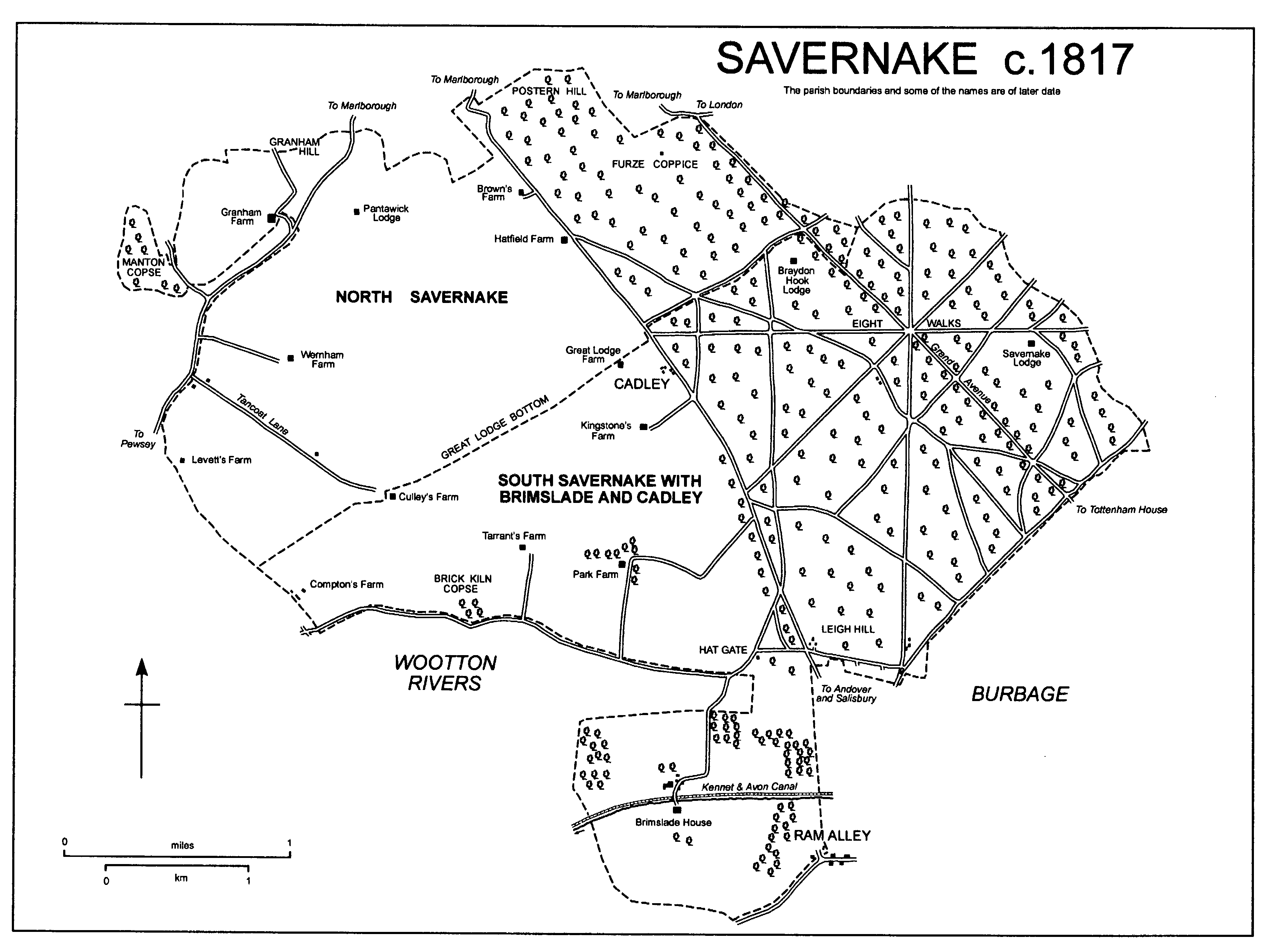
Savernake parish (fn. 1) lies immediately south of Marlborough. Its land is roughly conterminous with the main part of Savernake forest as defined in 1300 (fn. 2) and was extra-parochial. In the later 18th century the west part, which was parkland and agricultural land from the 16th century, lay in two tithings, each of which relieved its own poor. To the north Savernake Park North was a tithing of Selkley hundred, and to the south Brimslade and South Savernake was a tithing of Kinwardstone hundred: under the Relief of the Poor in Extra-parochial Places Act of 1857 each was deemed a civil parish, respectively with the names North Savernake, and South Savernake with Brimslade and Cadley. (fn. 3) The east part of the forest as defined in 1300 remained uninclosed and mostly woodland, (fn. 4) and by the late 19th century some of it, and land which was probably some of it, had become parts of parishes adjoining it. On the south-east, land used in common by the men of Great Bedwyn and of Stock in Great Bedwyn and apparently part of the forest became part of Great Bedwyn parish, as did Tottenham park which was presumably part of the forest in the 16th century. (fn. 5) In the 18th century the boundary between the forest and Burbage parish, which seems to have run east-west immediately north of Durley village, was called into question: by 1886 c. 1,000 a. north-east of that line had been transferred from the forest to the parish. (fn. 6) In the 19th century land of the forest on the north-east may have been added to Little Bedwyn, and on the north was apparently added to Mildenhall. (fn. 7) The rest of the forest was divided between North Savernake, 2,315 a., and South Savernake with Brimslade and Cadley, 3,531 a. North Savernake parish was increased in 1901, when 78 a. of Preshute parish was transferred to it, and reduced in 1925, when 32 a. of that land was transferred to Marlborough. (fn. 8) In 1934 North Savernake parish and South Savernake with Brimslade and Cadley parish were merged as Savernake parish, 2,384 ha. (5,892 a.). (fn. 9) In 1987 land was transferred to Savernake parish from Fyfield, Milton Lilbourne, Pewsey, Preshute, Wilcot, and Wootton Rivers parishes, and from Savernake to Burbage, Preshute, and Wootton Rivers: as a result Savernake was reduced to 2,318 ha. (fn. 10)
SAVERNAKE c. 1817
Few of the features which defined the boundary of the forest in 1300 are unequivocally points on the parish boundary; on the north-west a road which marked the forest boundary (fn. 11) was presumably on the course of that which marks the parish boundary. A park pale was erected on, or adopted as, part of the parish boundary on the south, and on the north and south-east forest drives were adopted as parts of the boundary with respectively Mildenhall and Burbage fixed in the 19th century. (fn. 12)
Except for its southern projection the parish lies on the Marlborough Downs and in the valley of the river Kennet. Chalk outcrops over the main part of the parish, except where Reading Beds and Bagshot Beds outcrop in small areas near the south-east boundary. The outcrops are extensively overlain by clay-with-flints, and gravel has been deposited in several valleys. All the valleys are now dry. The highest point in the main part of the parish is at 220 m. on the boundary in the south-west, and the lowest points are at c. 145 m. on the boundary in the north and east. The southern scarp of the Marlborough Downs crosses the neck joining the projection to the main part of the parish. The projection lies in the valley of the Christchurch Avon and is crossed from east to west by a head stream now intermittent. The chalk of the scarp face, of which the highest point is at c. 190 m., outcrops in the north part of the projection, Upper Greensand in the lower part to the south; the stream leaves the parish at 135 m. (fn. 13) The clay-with-flints can support dense woodland, which had been cleared from the west half of the parish by the 18th century. (fn. 14)
The population of Savernake Park North tithing was 67 in 1801. It rose from 79 to 127 between 1811 and 1821 and remained roughly constant until 1861, when it was 108. North Savernake parish had 89 inhabitants in 1871, 85 in 1901. The transfer to it of part of Preshute parish, including a hospital, caused the population to increase; it was 146 in 1911, 145 in 1921, and, after an increase in the number of patients at the hospital, 230 in 1931. The population of Brimslade and South Savernake tithing was 133 in 1801; if, as is likely, the Cadley which had 36 inhabitants in 1811 and 45 in 1821 was the Cadley in the tithing, the population was 136 and 155 in those years respectively. From 186 in 1831 it had risen to 230 by 1861. From 256 in 1871 the population of South Savernake with Brimslade and Cadley parish declined steadily to 147 in 1921. The population of Savernake parish declined from 355 to 197 between 1951 and 1981; in 1991, after the boundary changes of 1987, it was 194. (fn. 15)
The courses of two Roman roads, from Mildenhall to Old Salisbury, and between Cirencester and Winchester via Mildenhall, cross the parish. (fn. 16) In the Middle Ages a Marlborough-Salisbury road via Easton was probably on or near the course of the first, and an important Marlborough- Winchester road via Ludgershall and Andover (Hants) is likely to have been on a course south-west of and roughly parallel to the other. A Salisbury road via Easton would have been blocked by the imparking of the west part of Savernake forest in the 16th century, and in the later 17th century the Salisbury road, which north of Marlborough led from Chipping Campden (Glos.), shared the course of the Andover road between the parkland, then agricultural land, in the west part of the parish and the woodland in the east part. (fn. 17) The road was turnpiked in 1762 and disturnpiked in 1876; (fn. 18) it was still a main road in 1996. The north-west end of the parish is crossed by the Marlborough- Pewsey road, which, where it marks part of the parish boundary, is presumably on the course it followed in 1300. (fn. 19) Several public roads cross the woodland in the east part of the parish; apart from the Marlborough-Pewsey road, the west part, having been imparked, is crossed by none.
The Kennet & Avon canal was built c. 1807 beside the stream across the south projection of the parish. It was opened fully in 1810 and restored across the parish in the 1970s. (fn. 20) It has two locks in the parish.
The Berks. & Hants Extension Railway, built parallel to and immediately south of the canal, was opened across the parish in 1862. Since 1906 it has been part of a main London-Exeter line. Converging on it at Burbage a line from Marlborough was constructed as a loop through the west part of the parish and opened in 1864; a second Marlborough-Burbage line, the southern extension of a line from Swindon, was opened across the parish east of the first in 1898. The second line had a tunnel at the north end of Savernake parish. The line built in 1864 was closed in 1933; that built in 1898 was closed in 1964. (fn. 21)
Prehistoric remains have been discovered in all parts of the parish. An artefact possibly of the Mesolithic period is the oldest; later artefacts include a gold torc of the later Bronze Age. (fn. 22) Barrows in the parish include a group of eight in the southern projection, (fn. 23) there are four ditches (fn. 24) and a later Iron-Age enclosure of 3½ a. in the north, and a small part of a similar enclosure was identified in the south-west. (fn. 25) A field system of 40 a., also of the later Iron Age, lies on Postern Hill on the boundary with Marlborough. (fn. 26) The parish lies near an area notable for Roman settlement, and there may have been a settlement of the Roman period at Pantawick in the north-west. A hoard of 4thcentury coins was found on Granham Hill north-west of Pantawick, (fn. 27) and pottery was produced commercially from the late 1st century at kilns north of Leigh Hill in the south-east. (fn. 28) The east end of the East Wansdyke, a linear earthwork constructed probably between the 5th and 9th centuries, lies in the west part of the parish. (fn. 29)
Courts held to punish offences committed in Savernake forest were held at places which were afterwards in Savernake parish. A three-weekly court was held at Morley, possibly Leigh Hill, in the 13th century or earlier, and in the 16th century courts were held at Great Lodge and Bagden Lodge. Forest courts, known to have been held in the 17th century but not later, were attended by men from the villages with land bordering the woodland and mainly dealt with the unlawful killing of game, cutting of trees, and feeding of animals. (fn. 30)
Savernake parish contains no village. In the centre of it at Cadley, a hamlet so called in 1773, (fn. 31) a church, a vicarage house, and a school were built beside the Marlborough road in the mid 19th century. (fn. 32) A timber-framed and thatched cottage of the 17th century, a few estate houses of the 19th century built of red brick with patterning of blue and buff brick, (fn. 33) and a few later 20th-century houses also stood at Cadley in 1995.
In the west part of the parish, which apart from the land north-west of the Marlborough- Pewsey road was the land imparked in the 16th century, settlement was in isolated farmsteads built in the 17th century, when the land was converted to agriculture, or later. (fn. 34) None of the four lodges which stood in the park in the 16th century (fn. 35) survived in 1995.
Two farmsteads were built beside the Marlborough road. Brown's, so called in 1718, (fn. 36) incorporated a thatched and timber-framed house, presumably 17th-century, which was demolished in 1961-2 and replaced by a new house. (fn. 37) Hatfield, later High Trees, Farm, built of sarsen in the 17th century, had a main northwest and south-east range with a cross wing at the north-west end. In the earlier 19th century a red-brick block was built on the south-west side of the main range, and in the later 19th century a red-brick tower and a service range were built on the north-west side of the cross wing.
Two farmsteads were built in the dry valley called Great Lodge bottom. Great Lodge Farm may stand on or near the site of the great lodge which stood in the park in the 16th century. (fn. 38) It was built in the later 17th century with a main north-west and south-east range, having one room on either side of a central chimney stack, and with a single-storeyed range on the southeast and brick gables. The lower courses of the north-east front were of sarsen and the higher ones of brick. The south-west wall may have been timber-framed; it was rebuilt in brick in the 18th century when the single-storeyed range was raised to two storeys and extended southwestwards to give the house an L plan. An 18th-century timber-framed barn and a granary on staddle stones stand north-east of the house. Culley's Farm was on an L plan when it was built c. 1700. Its south-east wall is partly of sarsen; otherwise its walls are of red brick. In 1995 the house contained an early 18th-century staircase and a room fitted with panelling partly of c. 1700 and partly of the early 17th century.
Three farmsteads were built south-east of Great Lodge bottom. Kingstone's incorporates a timber-framed house built in the later 17th century as a short north-west and south-east range. The house was extended north-eastwards in brick later in the 17th century and south-eastwards in sarsen in the early 18th century, thus acquiring an L plan. Park Farm possibly stands on the site of Witheridge Lodge, which was mentioned c. 1620. (fn. 39) A wall built of sarsen rubble in the 17th century is incorporated in the farmhouse, otherwise built of brick c. 1800, on an L plan, and still standing in 1995. Tarrant's Farm, standing in 1718, (fn. 40) was demolished in the later 20th century. (fn. 41)
North-west of Great Lodge bottom Wernham Farm was standing in 1718. (fn. 42) Part of an 18thcentury garden wall survives south of the present farmhouse, which was built in the early 19th century. On the western edge of the former park Levett's Farm incorporates a farmhouse built in the earlier 18th century as a north-west and south-east range with walls of sarsen rubble and brick with ashlar dressings, and with a single room on each side of a central chimney stack. A lean-to was built on the north-east side of the house in the 18th century, and a two-storeyed block on the south-west side c. 1938. (fn. 43) South-east of Levett's Farm the west lodge of the former park was part of Compton's Farm, which was standing in the 17th century and early 18th. (fn. 44) In 1995 a red-brick cottage of the later 19th century stood on the site, from which the farm buildings were removed in the 20th century. (fn. 45) Near the northern edge of the former park Pantawick Lodge, standing in 1618, was demolished between 1840 and 1885. (fn. 46)
Levett's Farm and Compton's Farm stood on downland near several farmsteads and cottages in other parishes, each far from its parish church, and in the mid 19th century a room used as a school and a chapel of ease was built near Compton's Farm. (fn. 47) Near Levett's Farm, Overton Heath airfield was open from 1941 to 1948. Flying instructors were trained there and hangars and other buildings were erected. One of the hangars survived in 1995. (fn. 48)
North-west of the Marlborough-Pewsey road lies downland which was probably disafforested in 1330 (fn. 49) and was not imparked in the 16th century. Granham Farm was standing there in 1718. (fn. 50) The farmhouse was rebuilt in 1788 (fn. 51) of red and blue brick, is of two storeys and attics, and to the south-east has a main front of five bays.
In the east part of the parish, the land which remains mostly woodland, the sites of three lodges are known. A lodge on the site of Braydon Hook Lodge was standing c. 1600. (fn. 52) Braydon Hook Lodge, so called in the earlier 18th century, (fn. 53) was replaced in the later 19th century by a pair of cottages. Bagden Lodge, also standing c. 1600, (fn. 54) was replaced by a house built in 1717-18. The new house, (fn. 55) of two storeys and attics, consisted of a main north-west and southeast range with an east service wing, on a L plan, with its west corner attached to the east corner of the main range. The principal front, of seven bays with a pediment above the three central bays, was to the south-west. Some of the rooms were wainscotted. (fn. 56) In the later 18th century and early 19th a rectangular block was built on the north-east side of the main range, and a second rectangular block was built so that its west corner met the east corner of the first, and its south corner met the north corner of the service wing. (fn. 57) The house, which stood in a clearing called Savernake Lawn, was thereafter called Savernake Lodge. (fn. 58) In the later 19th century a single-storeyed extension incorporating a billiards room was built on the south-east side of the main range, but by 1886 the house, except that extension, had been demolished. In the earlier 18th century a north-east and south-west range, partly single-storeyed and partly twostoreyed and incorporating stables and coach houses, was built south-east of the house, and by 1886 that had been linked to the surviving part of the house to form a new house on an L plan which was standing in 1995. A small park had been laid out south-west of the house by 1806. (fn. 59) The third lodge stood in Furze coppice in the earlier 18th century. (fn. 60) In the earlier 19th it was replaced by a pair of cottages of brick and slate; later in the 19th century the building was enlarged and converted to a house, around which specimen trees were planted in a large garden. The house was extended c. 1980. A cottage stood beside a forest gate at the south end of the woodland in 1773. (fn. 61) A 20th-century house stood on its site in 1995.
Between the 1720s and the 1740s the park of Tottenham House in Great Bedwyn was redesigned, and two straight rides were made from the house through the woodland in the east part of what became Savernake parish, Column ride, which was made across the south part to the Andover road, and the Grand Avenue, which roughly follows the course of the Roman road on a more direct route to Marlborough. Where the Grand Avenue joined the London road stone gate piers were erected in the early 19th century. Between 1764 and 1786 the woodland was brought into the overall design of the landscape around Tottenham House, and drives, paths, and clearings were made in it. Many of the features designed then, including the rond-point called Eight Walks, survived in 1995. (fn. 62)
Brimslade.
The southern projection of the parish was part of Savernake forest in the Middle Ages, (fn. 63) later parkland, (fn. 64) and from the 17th century agricultural land. (fn. 65)
Brimslade House was built in the park in the earlier 17th century and was standing in 1995. It was on an L plan and timber-framed and had principal south and west fronts each with two gables. The east range, which was the longer and had a central porch, was extended eastwards in the mid 17th century. In the early 18th century a new staircase was built in the centre of the west range, and the two principal rooms in the east range were refitted. Panelling from those rooms may have been that of the earlier 17th century reset on the first floor and incorporating an overmantel bearing the painted arms of Seymour impaling Stanhope. (fn. 66) The timber-framed walls of the house have been partly covered by hung tiles and partly rebuilt in brick. From 1699 to 1787 the house was occupied successively by Michael Ernle, his son Edward (d. 1734), Sir Michael Ernle, Bt. (d. 1771), and Sir Edward Ernle, Bt. (d. 1787). (fn. 67)
By 1773 the head stream of the Avon, on the south bank of which Brimslade House stands, had been dammed to make ornamental canals, and a small park had been made around the house. (fn. 68) The canals were destroyed when the Kennet & Avon canal was built along the course of the stream c. 1807. (fn. 69) A formal garden survived on the north side of the canal in 1811, (fn. 70) but in the 19th century the house was a farmhouse and the park was not preserved. (fn. 71)
Brimslade House was linked to the north side of the Kennet & Avon canal by a bridge of stone and brick, and large farm buildings of red brick were erected on the north side in the early 19th century. In 1995 a 17th-century cottage, thatched and originally timber-framed, and a pair of mid 19th-century cottages, stood near the farm buildings; a lock keeper's cottage stood east of them.
East of Brimslade House a cottage in the parish is part of Ram Alley hamlet mainly in Burbage. (fn. 72) It is timber-framed and thatched and was built on the waste probably in the 17th century.
ESTATES.
SAVERNAKE forest, the main part of which was roughly conterminous with what became Savernake parish, belonged to the Crown almost throughout the Middle Ages and was usually held with Marlborough castle and its site. (fn. 73) From 1415 or earlier to 1447 it was held in fee by Henry IV's son Humphrey, duke of Gloucester. (fn. 74) Under a grant of 1547 it reverted on the death of Catherine Parr in 1548 to Edward Seymour, duke of Somerset, the hereditary warden of the forest. (fn. 75) Somerset was deprived of the forest in 1549; it was restored to him in 1550 and forfeited on his execution and attainder in 1552. In 1553 it was assigned by Act to his son Sir Edward Seymour (cr. earl of Hertford 1559, d. 1621). (fn. 76) Of what became Savernake parish both the east part, which remained woodland, and the west part, which was parkland and agricultural land from the 16th century, (fn. 77) descended from 1553 in the Seymour, Bruce, Brudenell, and Brudenell-Bruce families with Tottenham Lodge and Tottenham House in Great Bedwyn. (fn. 78) In 1939 George Brudenell-Bruce, marquess of Ailesbury (d. 1961), leased the woodland, c. 2,300 a., to the Forestry Commission for 999 years, (fn. 79) and in 1950 sold c. 3,200 a., nearly all the farmland, to the Crown, the owner in 1995. (fn. 80) The reversion of the woodland descended with Tottenham House and in 1995 belonged to David Brudenell-Bruce, earl of Cardigan. (fn. 81)
In 1618 Edward, earl of Hertford, sold 100 a. in the north-west part of the parish, part of what was later called BROWN'S farm, to his grandson Sir Francis Seymour (cr. Baron Seymour 1641, d. 1664). (fn. 82) The land presumably descended to Seymour's son Charles, Lord Seymour (d. 1665), and in turn to Charles's sons Francis, duke of Somerset (d. 1678), and Charles, duke of Somerset (d. 1748), who owned Brown's farm, 195 a., in 1718. From that Charles the farm descended to his son Algernon, duke of Somerset (d. 1750), and to his grandson Charles Manners, duke of Rutland, who in 1779 sold it to Thomas Bruce, earl of Ailesbury, the owner of the other land in the parish. (fn. 83)
The tithes of Savernake forest were taken by Salisbury cathedral from the 12th century, apparently by grant of the Crown as owner of the land. (fn. 84) In the earlier 17th century attempts to deprive the cathedral of tithes from land converted to agriculture were unsuccessful, (fn. 85) and in the early 19th century the dean and canons were taking all the tithes from what became Savernake parish. The tithes were valued at £690 in 1840 and commuted. (fn. 86)
ECONOMIC HISTORY.
As the main part of Savernake forest, what became Savernake parish was probably mostly woodland in 1300 (fn. 87) and until the later 16th century. (fn. 88) New plantations were made in the forest in the mid 16th century. (fn. 89)
In the later 16th century the west part of what became Savernake parish, excluding the land north-west of the Marlborough-Pewsey road, was impaled as Savernake great park. Much of the park was cleared of woodland, and red and fallow deer were kept in it. (fn. 90) In the 17th century the park was converted to agriculture. In the north part 100 a., later part of Brown's farm, was possibly used for agriculture from 1618, (fn. 91) and in 1633 c. 1,000 a. was pasture for sheep. (fn. 92)
The farm later called Great Lodge, 127 a., was leased in 1633; (fn. 93) that later called Park, 385 a., and that later called Hatfield, 240 a., were leased in 1634. (fn. 94) Three farms, those later called Wernham, 210 a., Levett's, 200 a., and Culley's, 150 a., were made from the west part of the park in 1649. (fn. 95) The farm later called Kingstone's, 214 a. including a former colt park of c. 100 a., was probably leased in the later 17th century, the date of its farmhouse. (fn. 96) To the south Tarrant's farm, 140 a., was made from part of a sheep pasture before 1686, (fn. 97) and Compton's farm, 205 a., was made from the former West walk of the forest before 1689. (fn. 98)
In 1718 Savernake great park was accounted 2,562 a., of which the 10 main farms had 2,426 a. The largest farm was Park, 385 a., the smallest Culley's, 145 a.; Wernham's and Tarrant's had been enlarged to 376 a. and 261 a. respectively. All the farms were almost entirely arable and they had a total of only 33 a. of meadow and pasture. The largest field was of 54 a., and the average size of the fields was c. 20 a. (fn. 99)
North-west of Savernake great park and of the Marlborough-Pewsey road Granham farm, 180 a., was entirely arable in 1718. By 1770 it had been increased to 239 a. by the addition of 44 a. south-east of the road and of 15 a. of steep downland in Preshute parish used as pasture for sheep. By 1840, when it had c. 412 a. including 74 a. in Preshute, it had been extended further south-east by the addition of 107 a. in the north-west part of the park. (fn. 100)
South-east of Savernake great park in the southern projection of the parish land may have been converted from parkland to agriculture in the earlier 17th century, when Brimslade House was built on it. (fn. 101) Brimslade park was accounted 590 a. in 1642, when it included 77 a. of meadows, 31 a. of pasture, 236 a. of arable, and 241 a. of woodland. (fn. 102) Much of the woodland had been cleared by 1773, when there was a park of c. 30 a. around Brimslade House. (fn. 103) In 1811 Brimslade farm, 493 a., included c. 385 a. of arable, was worked from buildings recently erected on the north side of the Kennet & Avon canal, and was probably worked with 29 a. in Burbage. Its pasture, c. 87 a., lay west and south of the farmstead. (fn. 104)
In 1840 of c. 3,400 a. in the west part of what became Savernake parish c. 2,440 a. was arable, 292 a. was meadow or pasture, and 345 a. was rough pasture for sheep. There were 12 farms, all mainly arable, but Brown's, Hatfield, and Great Lodge, a total of c. 670 a., were worked together, as were Kingstone's and Tarrant's, a total of c. 455 a., Levett's and Compton's, a total of c. 388 a., and Wernham's and Culley's, a total of c. 493 a. (fn. 105) In 1867 Levett's farm and Compton's farm were worked from Wootton Rivers as part of East Wick farm, and Brown's was a separate farm of 250 a., Park one of 372 a., and Granham one of 403 a. There were composite farms of 482 a. and 501 a.; Brimslade farm, 475 a., and Kingstone's and Tarrant's, then called Great Park farm, 482 a., were apparently worked together. (fn. 106) Between 1840 and 1886 New Buildings, a barn and other buildings, was erected on the composite Great Lodge and Hatfield farm. (fn. 107)
In 1867 sheep-and-corn husbandry was widely practised in the west part of what became Savernake parish, but from c. 1880 arable was laid to pasture and dairy farming increased. Pasture was at its most extensive c. 1930, (fn. 108) but c. 1933 there was slightly more arable than pasture. (fn. 109) Arable predominated c. 1995, when there were seven farms based in the parish. Brimslade, 568 a., Wernham, 378 a., and Levett's, 241 a., were entirely arable farms; Kingstone's, 703 a., was an arable and sheep farm, Brown's, 531 a., an arable and dairy farm, Culley's, 375 a., an arable, dairy, and beef farm, and Park, 384 a., a dairy farm. On Levett's farm free-range hens were kept. (fn. 110)
In 1718 only 9 a. of woodland was standing in Savernake great park. Manton copse covered 25 a. then, (fn. 111) 35 a. in 1840. (fn. 112) By 1885 it had been reduced to 14 a., (fn. 113) roughly its size in the late 20th century. (fn. 114) In the south projection of the parish woodland stood north-east and northwest of Brimslade House in 1773. (fn. 115) In 1811, after several copses had been planted in geometrical shapes, and Ram Alley copse, 27 a., had been planted, there was 87 a. (fn. 116) A triangular copse of 2 a. was removed between 1811 and 1840, and a circular copse of 3 a. and a copse of 7 a. were removed between 1840 and 1886. (fn. 117) The others were standing in the late 20th century, by when a few small copses had been planted in the former great park. (fn. 118)
The ancient woodland in the east part of Savernake parish, although privately owned from the 16th century, (fn. 119) was not impaled. In the 18th century the men of villages on its periphery had the right to feed in it in summer as many cattle as they could keep on their holdings in winter, and to each village the pasture of a separate part of the forest had been designated for its sheep to feed on. No farm in Savernake great park included any such pasture right. (fn. 120) The rights were probably largely extinguished in the later 18th century or early 19th when most of the holdings in those villages belonged to the owner of the forest. (fn. 121) In the 19th century some of the clearings which had been incorporated in the design of the landscape around Tottenham House in the 18th century were apparently used for agriculture. (fn. 122) In 1995 there was c. 200 a. of arable and pasture near Eight Walks. (fn. 123)
In the later 18th century coppices were amalgamated and areas of open heath were planted with oak and Spanish chestnut. In the later 19th century trees were damaged by herds of deer formerly confined to the park of Tottenham House. There was some replanting for commercial purposes between 1894 and 1911. (fn. 124) From 1939 the woodland was managed by the Forestry Commission. (fn. 125) Two nurseries were set up east of Cadley in the 1940s and abandoned in the 1960s. (fn. 126) In 1980-1 oak and beech trees were felled in the Grand Avenue, which was partly replanted in 1983, and in 1984 c. 1,000 beech, oak, and cherry trees were planted in the woodland. (fn. 127) Among many deciduous trees destroyed by storms in 1990 there were 700 beeches and 50 oaks. In 1995, when there was c. 2,300 a. of woodland in Savernake parish, coniferous trees were grown for timber on 20 per cent of Savernake forest, including the parts in other parishes. A site for camping was provided on Postern Hill in the 1960s; it remained in use in 1995, when the woodland was used for various leisure pursuits and contained a herd of fallow and roe deer. (fn. 128)
The clay deposits in the parish have been used for making bricks, and the sites of six brick kilns are known. A kiln east of Leigh Hill was in use in 1732 (fn. 129) and closed between 1910 and 1922; (fn. 130) Wernham kiln, in Tancoat Lane south-west of Wernham Farm, was in use in 1840 (fn. 131) and closed between 1886 and 1922. (fn. 132) A kiln west of Granham Farm was possibly in use in 1840; others north of Brown's Farm, where one was apparently in use c. 1820, and at Brick Kiln copse had apparently gone out of use by then. (fn. 133) A new kiln north of Brown's Farm was opened between 1885 and 1899 and closed between 1899 and 1922. (fn. 134)
At Cadley in 1995 the former school housed Dobie Wyatt Ltd., a company which made tarpaulins and employed 12 people there, (fn. 135) and the former vicarage house was a hotel. Horses were trained at Levett's Farm in the 1920s and 1930s. (fn. 136)
LOCAL GOVERNMENT.
Savernake Park North tithing was relieving its own poor in 1783. (fn. 137) In 1802-3, when its population was c. 67, it spent £119 on relieving 9 adults and 25 children regularly and 2 adults occasionally. (fn. 138) From 1812-13 to 1814-15 an average of £90 a year was spent and on average 8 adults were relieved regularly and 4 occasionally. (fn. 139) In the following two decades expenditure, at £54, was lowest in 1816 and, at £132, highest in 1830. (fn. 140)
Brimslade and South Savernake tithing was relieving its own poor in 1775-6, when it spent £79. In 1802-3, when the population was c. 133, 12 adults and 48 children were relieved regularly and 15 adults occasionally at a total cost of £111. (fn. 141) Expenditure reached a peak of £197 in 1830. (fn. 142)
Neither tithing joined a poor-law union and, subject to the Relief of the Poor in Extra-parochial Places Act of 1857, as a civil parish each apparently remained responsible for relieving its own poor. (fn. 143) Savernake parish became part of Kennet district in 1974. (fn. 144)
CHURCH.
In 1657, almost certainly after farmsteads had been built in Savernake great park and Brimslade park, it was proposed to build a church with the parks and the unimpaled forest as its parish. The proposal was not implemented until the 19th century. A church built at Cadley in 1851 or 1852 collapsed, was rebuilt, and was consecrated in 1854. (fn. 145) A district consisting of the later Savernake civil parish, except for the land north-west of the Marlborough-Pewsey road, and of the 78 a. of Preshute parish transferred to North Savernake civil parish in 1901, was assigned to the church as the ecclesiastical parish of Savernake, and a perpetual curate, from 1868 called a vicar, was licensed. (fn. 146) The ecclesiastical parish was renamed Savernake Christchurch in 1973, when the vicarage was united with Burbage vicarage. In 1975 the church was declared redundant and the parish was divided between Burbage, Marlborough, Preshute, and Wootton Rivers ecclesiastical parishes. (fn. 147)
In 1854 the patronage of the living was vested in Charles Brudenell-Bruce, marquess of Ailesbury. (fn. 148) It descended with Tottenham House to George, marquess of Ailesbury, who sold it to the dean and chapter of Salisbury in 1924. In 1915 the bishop of Salisbury had nominated by lapse. From 1973 the dean and chapter shared the patronage of the united benefice. (fn. 149)
In 1854 the incumbency was endowed with a house and £2,500 stock by Lord Ailesbury, and augmented with £100 of tithe rent charge by the Ecclesiastical Commissioners. (fn. 150) The house was sold in 1947. (fn. 151)
In the west part of the parish a room built near Compton's Farm c. 1855 for use as a chapel and a school was licensed in 1856 for divine service. Each Sunday in 1864 the curate held a morning service at Cadley church attended by c. 110 and an evening service there attended by c. 100. Weekday services in Lent and Advent and services on saints' days were attended by c. 75. Communion was celebrated monthly with c. 16 communicants and on Easter Sunday and Whit Sunday with c. 25. An afternoon service on Sundays held in the room near Compton's Farm was attended by c. 50, and in a similar room opened between 1861 and 1864 in or near Savernake Lodge in the east part of the parish a service was held on Friday evenings in winter. (fn. 152) There is no evidence of services after 1864 in the room in or near Savernake Lodge; the room near Compton's Farm has been closed apparently from the earlier 1960s. (fn. 153) The vicarage was held in plurality successively with Marlborough benefice from 1940 to 1947, (fn. 154) the vicarage of St. Katharine's, Savernake Forest, from 1947 to 1949, (fn. 155) Wootton Rivers rectory from 1965 to 1970, and Burbage vicarage from 1970. (fn. 156)
The church at Cadley, called CHRISTCHURCH, was built of sarsen rubble, with dressings and banding of limestone, to designs by T. H. Wyatt. (fn. 157) It is in a 14th-century style and consists of a chancel (fn. 158) with south vestry, a nave, and a south-west tower which incorporates a south porch. A chalice and paten, both of silver, and a glass flagon with silver mounts were given in 1855, (fn. 159) and there was one bell. (fn. 160)
NONCONFORMITY.
In the 1660s William Hughes, the ejected vicar of St. Mary's, Marlborough, preached to conventicles in Savernake forest. (fn. 161) There is no other evidence of nonconformity in what became Savernake parish.
EDUCATION.
Cadley school was built in 1850 and had 40-50 pupils in 1858. (fn. 162) In the 1860s the curate held a poorly attended evening school in the building. (fn. 163) The day school had 51 pupils in 1906, (fn. 164) 66 in 1908-9. In 1939, when there were 13 on the roll, it was closed. (fn. 165)
In the room built c. 1855 near Compton's Farm 20-30 pupils were taught in 1858. No later evidence of the use of the building as a school has been found. A school said to stand at Birch copse in the park of Tottenham House probably stood near Savernake Lodge. It had been closed by 1858. The room opened between 1861 and 1864 in or near Savernake Lodge was for use partly as a school; no evidence of a school held there after 1864 has been found. (fn. 166)
CHARITY FOR THE POOR.
None known.