A History of the County of Wiltshire: Volume 16, Kinwardstone Hundred. Originally published by Victoria County History, London, 1999.
This free content was digitised by double rekeying. All rights reserved.
A P Baggs, J Freeman, C Smith, J H Stevenson, E Williamson, 'Wootton Rivers', in A History of the County of Wiltshire: Volume 16, Kinwardstone Hundred, ed. D A Crowley (London, 1999), British History Online https://www.british-history.ac.uk/vch/wilts/vol16/pp229-236 [accessed 4 May 2025].
A P Baggs, J Freeman, C Smith, J H Stevenson, E Williamson, 'Wootton Rivers', in A History of the County of Wiltshire: Volume 16, Kinwardstone Hundred. Edited by D A Crowley (London, 1999), British History Online, accessed May 4, 2025, https://www.british-history.ac.uk/vch/wilts/vol16/pp229-236.
A P Baggs, J Freeman, C Smith, J H Stevenson, E Williamson. "Wootton Rivers". A History of the County of Wiltshire: Volume 16, Kinwardstone Hundred. Ed. D A Crowley (London, 1999), British History Online. Web. 4 May 2025. https://www.british-history.ac.uk/vch/wilts/vol16/pp229-236.
In this section
WOOTTON RIVERS
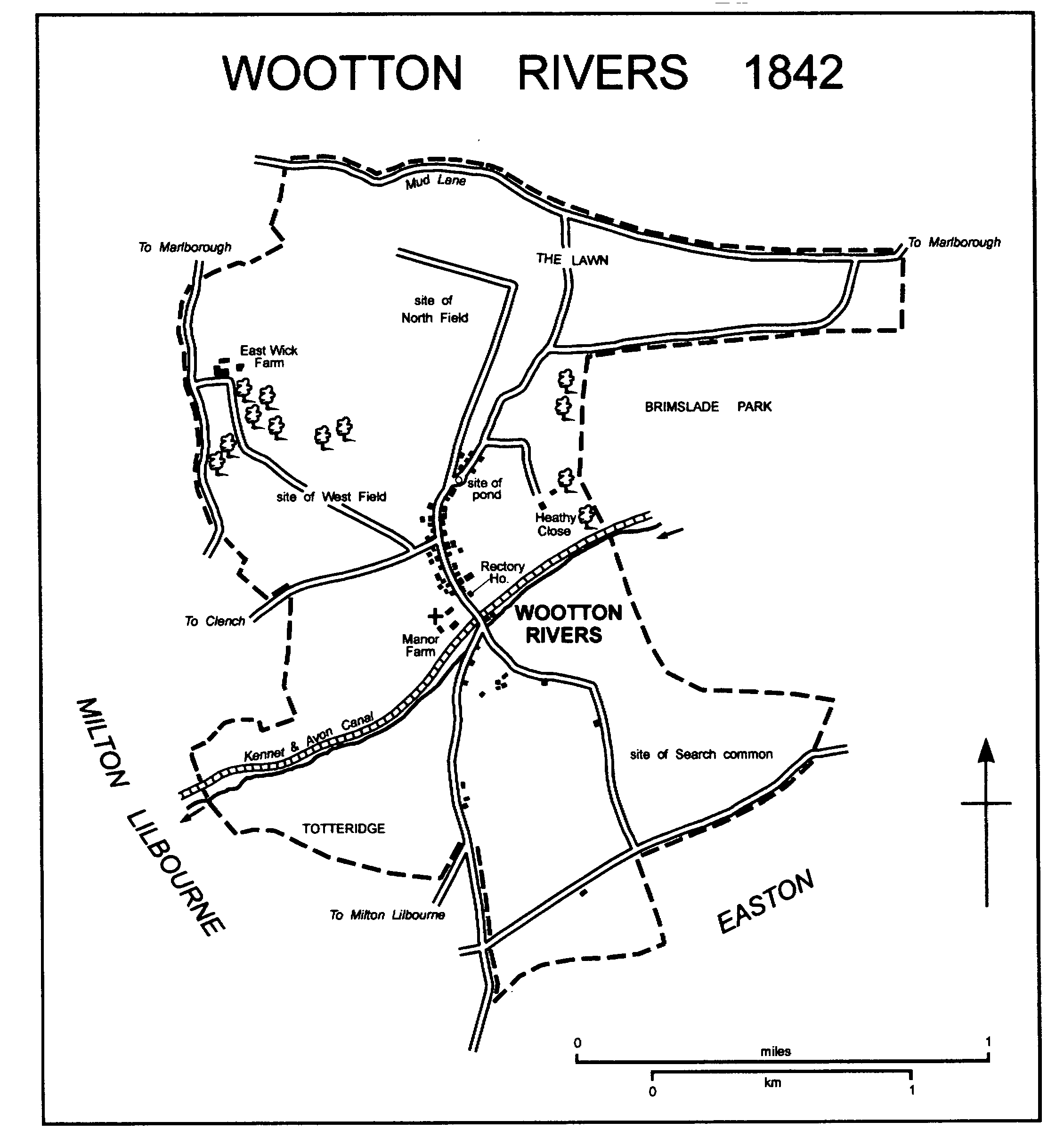
Wootton Rivers village lies 6 km. south of Marlborough. (fn. 1) Besides the village, the parish contains East Wick Farm, which possibly stands on the site of what was a small village in the Middle Ages. (fn. 2) The suffix in the parish's name is the surname of lords of the principal manor and was in use in the 14th century. (fn. 3) In 1300 the land between the eastern arms at the north and south ends of the parish, which either was or might soon have become part of the parish, was probably woodland and was defined as a southern tail of Savernake forest. It remained part of the forest in 1330, when the land east and west of it was disafforested, (fn. 4) and as Brimslade it remained extra-parochial until the 19th century. (fn. 5) Wootton Rivers parish measured 1,200 a. (486 ha.). In 1987 Brimslade was transferred to it from Savernake parish, and a small area was transferred from it to Savernake. Wootton Rivers parish thereafter measured 705 ha. (fn. 6)
The parish boundary follows a dry valley and a ridge on the south-east, but no prominent natural feature marks it elsewhere. On the north and in several other places it is marked by roads and paths. Sharp bends in the boundary with Milton Lilbourne may be partly the result of a compromise between the rector of Wootton Rivers and the appropriator of Milton Lilbourne church who disputed tithes c. 1215 and c. 1327. (fn. 7) The line of the boundary with Easton along a road was confirmed in 1908. (fn. 8)
Upper Greensand outcrops over the whole parish except its north end, where chalk outcrops and the southern scarp of the Marlborough Downs crosses the parish from east to west. A small area in the extreme north is overlain by clay-with-flints. (fn. 9) An intermittent head stream of the Christchurch Avon flows from north-east to south-west across the south half of the parish. To the north the land reaches 205 m. on the down at the western boundary, to the south, where it is undulating, it reaches 170 m. at the eastern boundary. The stream leaves the parish at 130 m. Open fields lay in the centre and north parts of the parish, common pasture in the south and on the downland in the north. The parish contained very little woodland. (fn. 10)
There were 51 poll-tax payers at Wootton Rivers in 1377; they presumably included the inhabitants of East Wick. (fn. 11) The population of the parish was 313 in 1801 and 367 in 1811. It was over 400 between 1821 and 1871, reaching a peak of 470 in 1841; it was between 300 and 400 in the period 1881-1911, between 300 and 200 thereafter. The parish had 247 inhabitants in 1981 and, after the boundary changes of 1987, 271 in 1991. (fn. 12)
The Roman road from Mildenhall to Old Salisbury, and in the Middle Ages a main Marlborough-Salisbury road, may have run north-south across the parish. The direct course of a Marlborough-Salisbury road through Wootton Rivers would have been blocked in the 16th century when north of the parish the west part of Savernake forest was inclosed as Savernake great park, and later the main Marlborough-Salisbury road ran further east. (fn. 13) Wootton Rivers village is linked to the present main road from Marlborough to Salisbury and Andover (Hants) by a lane leading north-eastwards and by others leading to Burbage. It is linked to another main Marlborough-Salisbury road, which runs through Pewsey, by three lanes, one via East Wick, one via Milton Lilbourne, and one via Clench in Milton Lilbourne; the lane via East Wick had been diverted south of the farmstead by 1732. The road along the northern boundary, in use in the early 18th century, has never been tarmacadamed and was a track called Mud Lane in 1997. (fn. 14)
The Kennet & Avon canal was built across the parish c. 1807 and was opened fully in 1810. (fn. 15) A wharf, a lock, and a lock keeper's house were built immediately south of the village, and there is another lock in the east part of the parish. The canal was restored in the 1970s and the locks were reopened in 1973. (fn. 16)
The Berks. & Hants Extension Railway, built parallel to and immediately south of the canal, was opened across the parish in 1862. Since 1906 it has been part of a main London-Exeter line. A passenger halt was opened at the south end of the village in 1928 (fn. 17) and closed in 1964. (fn. 18) Two railways from Marlborough, one opened in 1864 and the other, part of a Swindon-Andover line, in 1898, crossed the north-east tip of the parish. They were closed in 1933 and 1964 respectively. (fn. 19)
A barrow at the north-east end is the only evidence of prehistoric activity in the parish. (fn. 20) The parish was in Savernake forest until 1330, when the whole of what was the parish until 1987 was disafforested. (fn. 21)
The church, the rectory house, and the demesne farmstead of Wootton Rivers manor stand as a group at the south end of the village. (fn. 22) The church stands on rising ground and, when it was built in the 14th century, replaced a church which may have stood on a lower site. (fn. 23) The demesne farmhouse, called Manor Farmhouse in 1997, is two-storeyed and mostly thatched. (fn. 24) At its west end it incorporates part of a medieval house built of large blocks of limestone; that part may have been the chamber wing of a house which c. 1600 was probably large. There survive in it a timber ceiling with heavily moulded beams and chamfered joists on the ground floor, a heavily moulded beam on the first floor, and three four-centred headed doorways. One of those doorways is in the west wall and is double-chamfered; a large, blocked, chamfered, three-centred arch abuts it and may be older. The surviving walls of the medieval house were patched with flint and rubble in the 17th century and with brick in the 18th; a mullioned window was inserted in the north wall in the 17th century. The part of the house which stood east of the medieval walls was replaced by a timber-framed range of three bays and a half built in the 17th century, possibly in 1680. (fn. 25) In the 18th century the lower part of the south wall of that range was rebuilt in brick and rubble, two bays built of brick were added on the east, and the house was reroofed. In the west wall, probably in the 18th century, large segmentalheaded openings were made and a brick arch was built within the medieval one. In the 19th century an outbuilding was attached to the house at the east end of the north front. In the late 20th dormer windows were constructed, the outbuilding was converted to part of the house, and there were many minor alterations.
The copyhold farmsteads of Wootton Rivers manor were built north of the demesne farmstead beside a curving north-south street. (fn. 26) The street runs along a valley a little west of the floor, and at its north end was served by a pond in which the water of a stream flowing, perhaps intermittently, southwards down the valley was trapped. Between Manor Farm and the pond, which was apparently filled between 1732 and 1842, there were probably 25-30 houses beside the street in 1732 (fn. 27) and most, including several built in the late 16th or early 17th century, were standing in 1997. There was some rebuilding in the 18th century, and in the 19th a school and a nonconformist chapel were built, (fn. 28) but the main period of building after the 17th century was the 20th.
Most of the village was designated a conservation area in 1975. (fn. 29) In 1997 c. 25 houses built before 1800, nearly all of them thatched, stood in the street. On the east side near the south end Church Farmhouse, built c. 1600, is of three bays with stone chimney stacks between the bays. The heavy, square-panelled, timber frame of its back wall survives; its front wall was rebuilt in brick in the 18th century. After a fire in 1978 the house was raised from 1½ storey to 2 storeys and its roof was changed from thatch to tiles. (fn. 30) Further north on the east side Somerset Farm is a three-bayed timber-framed house of the 17th century, and the Royal Oak is an extended and altered house of 17th-century origin. The Royal Oak was open as a public house from 1848 (fn. 31) or earlier and in 1997. On the west side of the street Noyes Farmhouse is another three-bayed, timber-framed, 17thcentury house; in the 18th century its east and main front was clad in brick, in the early 19th century it was extended south by two bays, and in the mid 20th century its interior was altered and a single-storeyed west extension was built. Further north on the west side of the street St. John's Cottage, timber-framed and of the late 16th century or early 17th, unusually for Wootton Rivers was built on an L plan.
By 1732 cottages, including a timber-framed one and a brick one dated 1717, both of which survive, had been built on the waste at the north end of the street near the pond. (fn. 32) In the main part of the street a village hall and c. 15 houses were built in the 20th century. Off the street to the west four council houses and two council bungalows were built in South Bank in the early 1950s, (fn. 33) at the south end of the street four estate cottages were built in 1961, and at the north end of the street north of the site of the pond several houses and four bungalows for old people were built in the 20th century. In the later 20th century that north part of the street was called Forest Road.
When the railway was built in 1862 a lane to Milton Lilbourne was diverted to run beside and south of it for c. 150 m.; (fn. 34) that part of the lane was later called Station Road. Off Station Road 10 council houses were built between 1924 and 1945. (fn. 35)
East of Wootton Rivers village a farmstead called Heathy Close was standing in 1732: a mid 20th-century house stood on the site in 1997. In the south part of the parish a small group of cottages and houses stood c. 350 m. south-east of the church in 1732. Of five houses standing there in 1997 one, of red brick and thatch, survived from 1732, and another, Flitwick House, was built of red brick with decorations of grey brick between 1842 and 1886. On other sites south-east of the village buildings standing in 1732 and 1842 had been demolished or replaced by 1997. South of the village a hamlet beside the Milton Lilbourne lane had taken the name Cuckoo's Knob by 1886. A thatched house standing there in 1732 (fn. 36) and possibly of 17th-century origin survived in 1997, as did a brick house, built in 1738 (fn. 37) and extended later, and two pairs of 19th-century cottages. A pair of council houses was built at Cuckoo's Knob in the 1930s and four bungalows for old people later. West of the village a new farmstead, Lady Margaret Farm, was built c. 1972. (fn. 38)
WOOTTON RIVERS 1842
East Wick.
In the Middle Ages East Wick was the name of a manor on which there were customary tenants (fn. 39) and, like its neighbours Wick (later Clench) in Milton Lilbourne parish and West Wick in Pewsey parish, (fn. 40) may have been a small village. East Wick Farm may stand on the site of a demesne farmstead which was probably standing in the 14th century; (fn. 41) it was the only farmstead at East Wick in the 18th century and almost certainly in the 16th. (fn. 42) The present farmhouse, tall, three-bayed, and of red brick and flint, was built in the late 18th century or early 19th; it was extended in the later 19th century. In 1997 it stood among extensive farm buildings of the 19th and 20th centuries. South of it a pair of cottages of 1977 and a house of 1984 replaced buildings of the mid or later 19th century. (fn. 43)
MANORS AND OTHER ESTATE.
Between 801 and 805 Byrhtelm gave Wootton, almost certainly including what was later the land of Wootton Rivers, to Ealhmund, bishop of Winchester, and his see in an exchange. (fn. 44) There is no evidence that it belonged to the see later. A large estate called Wootton was held by Queen Edith in 1066 and by the king in 1086. The estate, which was assessed at 30 hides and on which two churches stood, (fn. 45) almost certainly included more land than what was later Wootton Rivers parish. The additional land most likely to have been included in the estate is that of Easton, which may then have had a church and, because in the mid 12th century it was the marshal's, may have been the king's in 1086. The estate may also have included the land of Wick in Milton Lilbourne parish which, because it was later an endowment of Battle abbey (Suss.), may also have been the king's in 1086. Neither Easton nor Wick was mentioned in Domesday Book. Of other nearby places not mentioned in Domesday Book, Froxfield was held with Wootton in the early 9th century, and Milton Lilbourne is likely to have been part of an estate other than Wootton in 1086. (fn. 46)
WOOTTON RIVERS manor was held by Walter Giffard, earl of Buckingham (d. 1164), half of whose estates had been acquired by William Marshal, earl of Pembroke (d. 1219), by 1190. (fn. 47) The manor had been subinfeudated by 1202, when Marshal was overlord. (fn. 48) Thereafter the overlordship descended with the lordship of Wexcombe manor in Great Bedwyn. (fn. 49)
By 1202 the lordship in demesne of Wootton Rivers manor had been held by Walter de Leites, surrendered by him to William Marshal, and granted by Marshal to Walter de Rivers (fl. 1212) for 1 knight's fee. (fn. 50) In 1222 Rivers's relict Margaret and William de Rivers had interests in the manor, (fn. 51) which in 1242-3 was held by another Walter de Rivers. (fn. 52) The manor passed to Walter's son Richard (d. by 1304), to Richard's son John (fn. 53) (d. c. 1314), and in turn to John's sons Thomas, (fn. 54) a minor, (fn. 55) and John, who, while a minor, held it in 1325. (fn. 56) In 1330 Rose, the relict of, presumably the younger, John Rivers, held a third of it as dower. Sir Robert Bilkemore and his wife Anstice held the manor, including the reversion of Rose's portion, from 1330 or earlier. (fn. 57) In 1346 they were disputing the title to all or part of it with Simon Simeon, perhaps Rose's husband, and Thomas Rivers, perhaps her son, (fn. 58) and in 1351 Sir Robert and Anstice conveyed the manor to Thomas (fn. 59) (d. 1375). From the death of Thomas, who had a son John, the manor was held for life by his relict Isabel; (fn. 60) it was held by Isabel in 1377, (fn. 61) by Hugh Craan, perhaps her husband, in 1384 and 1403. (fn. 62) By 1412 the manor had passed, presumably by inheritance, to Thomas Rivers. (fn. 63) In 1428 it was held by Roger Rivers, (fn. 64) and in 1441 was sold by Henry Rivers to Sir John Seymour. (fn. 65)
From the death of Sir John Seymour in 1464 Wootton Rivers manor was held by his relict Isabel, on whose death in 1485 it passed to his grandson John Seymour. (fn. 66) From John's death in 1491 (fn. 67) it was held by his relict Elizabeth (fl. 1536). (fn. 68) It reverted to John's grandson Sir Edward Seymour (cr. Viscount Beauchamp 1536, earl of Hertford 1537, duke of Somerset 1547), on whose execution and attainder in 1552 it passed by Act to his son Sir Edward (cr. earl of Hertford 1559, d. 1621), a minor. From 1553 to 1675 it descended with Tottenham Lodge in Great Bedwyn successively to William, duke of Somerset (d. 1660), William, duke of Somerset (d. 1671), and John, duke of Somerset (d. 1675), (fn. 69) and it passed like Pewsey manor to Sarah, duchess of Somerset (d. 1692). (fn. 70) By her will Sarah gave Wootton Rivers manor to St. John's College, Cambridge. (fn. 71) The college owned c. 850 a. in the parish in 1840, (fn. 72) 675 a. in 1997. (fn. 73) In 1964 it sold Church farm and Somerset farm, a total of c. 150 a., to Charles Antrobus, whose relict Mrs. Pamela Antrobus owned them in 1997. (fn. 74)
At his death c. 1330 William Harding held 2 yardlands at East Wick in chief and land, not held in chief, consisting of what was later called EAST WICK manor and of land which, near East Wick, lay in Milton Lilbourne and Pewsey parishes. The whole estate descended to his daughter Anstice (fn. 75) (d. 1353), wife of Sir Robert Bilkemore (d. 1361). Probably on Bilkemore's death it passed to Anstice's grandson (Sir) John Lillebonne, (fn. 76) who by 1368 had given it to Thomas Hungerford in an exchange. (fn. 77) In 1369 Hungerford conveyed the estate to trustees, (fn. 78) and in 1371 Henry Sturmy conveyed that part of it which was not held in chief to Easton priory. (fn. 79) By an exchange licensed in 1390 the priory apparently gave the land near East Wick and in other parishes to Sir William Sturmy. (fn. 80) East Wick manor was held by the priory until the Dissolution (fn. 81) and was apparently granted with Easton Druce manor in Easton to Sir Edward Seymour, Viscount Beauchamp, in 1536. (fn. 82) From 1553 East Wick manor passed with Tottenham Lodge and Tottenham House in Great Bedwyn in the Seymour, Bruce, Brudenell, and Brudenell-Bruce families and, from 1552 or earlier to 1675, with Wootton Rivers manor. (fn. 83) George Brudenell-Bruce, marquess of Ailesbury, sold it to the Crown in 1950. In Wootton Rivers parish in 1997 the Crown owned c. 200 a., of which c. 150 a. was part of East Wick farm. (fn. 84)
In 1268 Gillian Bowcliffe held 1 yardland at East Wick which was later held with the keeping of part of Savernake forest. William Bowcliffe held it in 1275, (fn. 85) and in 1315 he or another William Bowcliffe conveyed it to William Harding, (fn. 86) who held other land at East Wick with the office of a forester of Savernake forest. (fn. 87) At his death c. 1330 Harding held 2 yardlands for service as keeper of the west bailiwick of the forest. (fn. 88) The land descended with East Wick manor until 1371 when, as land held in chief, it was retained by Henry Sturmy. (fn. 89) It descended with Burbage Sturmy manor from Henry (d. 1381) to Sir William Sturmy (d. 1427) and Sir John Seymour (d. 1464). (fn. 90) From 1441 it also descended with Wootton Rivers manor and was presumably merged with that or East Wick manor. (fn. 91)
ECONOMIC HISTORY.
In 1086 the estate called Wootton, which almost certainly included land not later part of Wootton Rivers parish, had land for 30 ploughteams. On 13 hides 1 yardland of demesne there were 2 teams and 12 servi; 40 villani and 17 coscets had 14 teams. There were 6 a. of meadow and 18 square furlongs of pasture. (fn. 92)
There is no evidence that the demesne of Wootton Rivers manor included land in open fields. In 1314 it consisted of 118 a. of arable, 6 a. of meadow, a several pasture of 20 a., and a pasture called Totteridge which lay south-west of Wootton Rivers village adjoining pasture called Totteridge in Milton Lilbourne parish. (fn. 93) In the later 16th century the demesne consisted of c. 110 a. and lay, as it probably did in 1314, in closes south-west of the village and near the demesne farmstead. Totteridge close was then accounted 20 a. The demesne also included the right to feed cattle and 300 sheep on the common pastures of Wootton Rivers. (fn. 94)
In 1314 the customary tenants of Wootton Rivers manor were seven yardlanders, three ½-yardlanders, and five cottars; none of them owed labour service. (fn. 95) In the later 16th century the manor included 10 yardlands in 10 copyholds; there was c. 22 a. to each yardland, most of which lay in the open fields. The largest holding was of 45 a., the smallest of 11 a.; each had a farmstead presumably in the village street. There were also six copyholders each with a cottage and between 2 a. and 12 a. Around the village there was then 10-20 a. of home closes and, mainly east of the village where land lay inclosed as Heathy closes, the copyholders had c. 35 a. in small closes of meadow and pasture and the glebe included 14 a. in closes. (fn. 96)
The open fields of Wootton Rivers, shared by the copyholders and the rector, lay mainly northwest of the stream which flows across the south part of the parish from north-east to south-west; the scarp of the downs, which lies east-west across the north part, diminishes in steepness from west to east and was ploughed. In the Middle Ages there were probably two main fields, one north of the village and one west. By the later 16th century, when there were fields called North-east and North-west, the north field had apparently been subdivided. Southbrook was an open field of c. 6 a. lying south-east of the village and of the stream. In the 16th century the downland, called the Lawn, north of the scarp, and much of the land south-east of the stream was common pasture for sheep and cattle, and there was a small common meadow called West moor. The copyholders had feeding in common for 727 sheep, the rector for 60, the lessee of the demesne for 300, and the lessee of East Wick farm for 120; as many cattle could be fed in common as could be kept on each holding in winter. (fn. 97)
In 1607 West field, the common pasture, then called Search, south-east of the village, and a common pasture called Inlands were inclosed by agreement. Common rights over West field, probably c. 75 a., were eliminated, but the land continued to be worked in small parcels and in 1842 most of the fields west of the village were of less than 5 a. Search, 275 a., and Inlands, 10 a., were allotted at the rate of 13 a. for the right to feed 60 sheep, and in 1842 there remained c. 10 fields of c. 13 a. south-east of the village. (fn. 98) The Lawn, 160 a., had been inclosed, divided, and allotted by 1682. (fn. 99)
Southbrook field and 130 a. north of the village remained open arable, and in the later 17th century the 130 a. lay as Great North field and Little North field. (fn. 100) Southbrook field and the 130 a. were inclosed by Act of 1836: the land lay inclosed in 1838 although an award was not made until 1842. (fn. 101)
In the early 18th century the demesne of Wootton Rivers manor was held on leases in portions. In 1732 it was a single farm, later called Manor farm, of 237 a. In 1795 the farm had 274 a. Most other farms in the parish apparently remained small; apart from East Wick farm none is known to have exceeded 100 a. in the 18th century. (fn. 102) In 1842 Manor farm had 265 a., copyholds totalling 291 a. may have been worked as a single farm, c. 240 a. of Wootton Rivers's land was held by the tenant of East Wick farm, and there may have been three farms each of c. 50 a. worked from farmsteads in the street. All but c. 100 a. was arable. (fn. 103)
Manor farm remained largely arable in the mid 19th century, and in 1860 the principal crops grown on it were wheat and legumes. (fn. 104) Later in the 1860s c. 20 cattle and 500-600 sheep were kept on it and wheat and a feed crop of turnips were grown. (fn. 105) In the later 19th century and the early 20th dairying was increasingly important in the parish and milk was sent to London by rail. (fn. 106) In 1910 Manor farm had 328 a. and there were apparently five other farms, of which the largest was 167 a., based in Wootton Rivers village. East of the village 55 a. was then worked from Savernake parish as part of Brimslade farm, (fn. 107) as it was in 1997. (fn. 108) From 1912 to 1942 the farm of 167 a. was held on lease by Wiltshire county council and sublet as smallholdings. (fn. 109) After 1945 some dairy herds were replaced by cattle reared for beef. (fn. 110) From 1972 most of Wootton Rivers's land has been worked with land outside the parish as part of East Wick farm and devoted to arable and dairy farming. (fn. 111)
The estate called Wootton in 1086 had on it 36 square furlongs of woodland. (fn. 112) A few small copses were standing on Wootton Rivers's land in the earlier 18th century, the earlier 19th, and in 1997; one of 4 a. east of the village was grubbed up between 1842 and 1886. (fn. 113)
A mill said in 1194 to stand at Wootton (fn. 114) probably stood at Wootton Bassett. (fn. 115)
In the 19th century coal was unloaded at Wootton Rivers wharf on the Kennet & Avon canal, and a passenger boat plied between Wootton Rivers and Devizes until 1851. (fn. 116) Thomas Holmes, an iron founder and machine maker, was working at Wootton Rivers in 1848, and between 1855 and 1859 a firm of iron founders, engineers, and agricultural implement makers, Oatley & Morris, later Oatley & Whatley, began trading there. The firm apparently left the parish between 1865 and 1867, presumably for Pewsey. (fn. 117) From 1975 to 1985 SSI Ltd. made scientific instruments at Wootton Rivers; (fn. 118) in 1997 the company was in business in Pewsey.
East Wick.
In the Middle Ages East Wick may have been a small village with its own small open fields. In 1330 the manor had as demesne 93 a. of arable and the hay from 4 a. of meadow and had on it 2 yardlanders and 12 cottars as customary tenants. (fn. 119) East Wick farm, 113 a., probably included all East Wick's land in the earlier 16th century, when it had 4½ a. of meadows, 77 a. of pastures, and 31 a. of arable, all in severalty. Its arable lay in fields of which the names, North and South, (fn. 120) suggest that they were formerly open, and the farmer was presumably entitled, as he was later, to feed cattle and sheep in the common pastures of Wootton Rivers. The farmstead from which the farm was worked almost certainly stood on or near the site on which the present East Wick Farm had been built by the 18th century. (fn. 121)
From 1570 or earlier East Wick farm had land in Clench in Milton Lilbourne parish in addition to that in Wootton Rivers. (fn. 122) About 1600 it had 210 a. and included 106 a. of arable, 22 a. of meadow, and 76 a. of pasture; the farmer then had feeding for 120 sheep in Wootton Rivers and for 240 in Clench. (fn. 123) To replace feeding for cattle and sheep on Search common in Wootton Rivers 25 a. was allotted in 1607. (fn. 124) In Wootton Rivers parish in 1732 East Wick farm had 143 a. lying as a strip along the parish boundary north and south of the farmstead. (fn. 125) In 1842 the farm, 449 a., consisted of that land and 306 a. adjoining it in Clench; the tenant also held c. 240 a. elsewhere in Wootton Rivers. (fn. 126) In 1910 the farm had c. 470 a., including the 143 a. but not the other land in Wootton Rivers. (fn. 127) In 1972 most of the land of Wootton Rivers was added to East Wick farm, thereafter an arable and dairy farm of c. 1,500 a. A new dairy, Lady Margaret Farm, was built c. 1972, and in 1997 a dairy herd of over 300 cows was kept. (fn. 128)
A copse of 7 a. stood immediately south of East Wick Farm in 1732. (fn. 129) It was grubbed up between 1842 and 1886. (fn. 130)
LOCAL GOVERNMENT.
Records of the court of Wootton Rivers manor survive for 1455-6, 1561-4, and 1575, for several years in the 17th century, for 1702, and for 1710-1900. From the 17th century the court was called a court baron. It was not usually held more than once a year and its main business was always to record the death of tenants and surrender of and admittance to copyholds. In 1455-6 it ordered the repair of tenements and the making of hedges, in 1575 the inheritance customs of the manor were presented, and from the 17th century rules were made for feeding animals in common. (fn. 131) A court was apparently held for East Wick manor in the 14th century. (fn. 132)
The parish spent £49 on poor relief in 1775-6, an average of £81 in the three years beginning 1782-3, and £107 in 1802-3 when regular relief was given to 14 adults and 6 children, occasional relief to 21 people. (fn. 133) The number receiving regular relief had risen to 32 by 1813, when £371 was spent. (fn. 134) In the 1820s and early 1830s spending fluctuated between £131 and £348: it was usually between £200 and £250. (fn. 135) Wootton Rivers became part of Pewsey poor-law union in 1835, (fn. 136) and of Kennet district in 1974. (fn. 137)
CHURCH.
A church belonging to the abbey of Mont St. Michel (Manche) stood at Wootton Rivers in 1086; it was one of two churches on the estate called Wootton, the second of which may have stood at Easton. (fn. 138) In the early 13th century Wootton Rivers church was served by a rector, and the abbey was entitled to a pension from its revenues. (fn. 139) In 1991 the rectory was united to Pewsey rectory and the united benefice of Easton and Milton Lilbourne to form a new Pewsey benefice. (fn. 140)
In 1212 the abbey of Mont St. Michel and Walter de Rivers, lord of Wootton Rivers manor, agreed that each should present alternate rectors. (fn. 141) There is no evidence that the abbey ever presented, and the advowson descended with the lordship of the manor. In the name of the lord of the manor, who was then a minor, three separate claimants each presented a candidate for the rectory in 1321; a fourth candidate was collated by the ordinary. (fn. 142) Simon Simeon, who presented in 1349 and 1350, possibly had an interest in part of the manor. (fn. 143) In 1425 Sir William Sturmy presented, possibly by grant of a turn, in 1555 the Crown presented because the lord of the manor was its ward, and in 1629 Roger Sherfield presented by grant of a turn. (fn. 144) Sarah, duchess of Somerset (d. 1692), devised alternate rights of presentation to St. John's College, Cambridge, and Brasenose College, Oxford: (fn. 145) the first presentation after 1692 was by St. John's College in 1728. (fn. 146) From 1991 the colleges have been members of the board of patronage for Pewsey benefice. (fn. 147)
In the Middle Ages the rectory was poor: it was valued at £5 in 1291, (fn. 148) was exempt from taxation because of its poverty in the late 15th century, (fn. 149) and was valued at £8 in 1535. (fn. 150) At £379 its value was close to the diocesan average c. 1830. (fn. 151) The rector was entitled to all tithes from the parish. (fn. 152) They were valued at £405 in 1838 and commuted in 1843. (fn. 153) The glebe was accounted 40 a. in 1341, (fn. 154) later as 1 yardland. In the later 16th century it consisted of 15 a. in closes, the first cut of ½ a. of meadow, a nominal 10 a. in the open fields, and feeding for cattle and 60 sheep. The rector was allotted 13 a. of Search common when it was inclosed in 1607 (fn. 155) and 8 a. of the Lawn when it was inclosed. In the late 17th century he held 41 a. in closes and the nominal 10 a. (fn. 156) He was allotted 6 a. at the inclosure of c. 1836 (fn. 157) and held 49 a. of glebe in 1842. (fn. 158) The rector sold 44 a. in 1917. (fn. 159) The rectory house was replaced by one built in the early 18th century and said in 1732 to be new. (fn. 160) The new house, doublepile and red-brick, had a main west front of five bays, the central three of which project; in 1997 early 18th-century fireplaces and panelling remained in the principal rooms of the west part of the house. In the earlier 19th century a tall façade, of red and blue chequered brick with a pedimental gable flanked by chimney stacks, was built on the south, which was converted to an entrance front; in the same period a similar façade and a service room were built on the north, and a large drawing room raised over a basement was added on the east. In the 1960s a south doorcase in neoclassical style was added and steps were built from the drawing room to the garden. (fn. 161) The house was sold in 1960. (fn. 162) A new one built north of it was sold in 1971. (fn. 163)
In 1550, when the rector lived outside the parish, communion could not easily be administered in the chancel because its roof was in such bad repair. (fn. 164) Peter Waterman, rector from 1630, was accused in 1646 of preaching and of using the threat of exclusion from communion in support of the royalist cause. He was also said to have done manual labour unfitting for a minister. He had been sequestrated by 1653, restored by 1660. (fn. 165) Under the will of Sarah, duchess of Somerset, from 1728 to 1905 each rector held a scholarship endowed by the duchess at either St. John's College or Brasenose College. (fn. 166) In 1783 a morning and an afternoon service were held each Sunday and services were held on fast days and on days following great festivals. Some poor parishioners rarely went to church, saying that they had no suitable clothes, and few attended the weekday services. Communion was celebrated at Christmas, Easter, and Whitsun and on the Sunday after Michaelmas. The number of communicants, c. 40 at Easter, was said to be rising because religious tracts had recently been distributed in the parish. Inhabitants of Brimslade and South Savernake tithing, which was extra-parochial and in which no church was built until c. 1854, attended Wootton Rivers church. (fn. 167) By 1812 the number of communicants in Wootton Rivers had fallen to 12. (fn. 168) On Census Sunday in 1851 a morning service was attended by 147 people, an afternoon one by 92. (fn. 169) In 1864, in addition to Sunday services, there were services at the great festivals. Communion was celebrated at Christmas and Easter, on Whit and Trinity Sundays, and on the first Sunday of each month; of 20 communicants, between 7 and 10 usually received. (fn. 170) From 1965 to 1970 the rectory was held in plurality with Savernake (Christchurch) vicarage and from 1971 to 1986 with the united benefice of Easton and Milton Lilbourne. (fn. 171)
The church of ST. ANDREW, so called in 1763, (fn. 172) is built of flint with sarsens and has an undivided chancel and nave with south porch and west bell turret. Most of the building is 14th-century. The roof, incorporating turned posts, which rest on collars, and cusped braces is apparently 17th-century. A wooden screen separating the chancel and the nave had been removed by 1812. (fn. 173) In the early 19th century the church had a plain weatherboarded bell turret with a pyramidal cap and a vane. (fn. 174) About 1861 it was restored conservatively to designs by G. E. Street: (fn. 175) the roof covering was renewed and the bell turret was replaced by a taller one with decorative bracing and a tiled broached spire.
In 1553 plate weighing 2½ oz. was confiscated and a chalice of 11 oz. was left in the parish. A chalice and paten cover made later in the 16th century belonged to the parish in 1891 and 1997. (fn. 176)
Three bells hung in the church in 1553. A ring of five bells cast in 1793 by Robert Wells of Aldbourne hung in the turret in the 1920s and in 1997. (fn. 177)
Registers of baptisms, marriages, and burials survive from 1728. (fn. 178)
NONCONFORMITY.
A meeting house for Methodists was licensed in 1821. (fn. 179) A Methodist chapel was built in 1881 (fn. 180) and closed in 1967. (fn. 181)
EDUCATION.
In 1783 a few children were taught at a school probably in the parish. (fn. 182) Four schools were open in 1818, (fn. 183) two, with a total of 39 pupils, in 1833. (fn. 184) A Church of England school was opened in 1845; (fn. 185) in 1846-7 there were 74 pupils at that and one other school in the parish. (fn. 186) In 1848 the church school was endowed with £150 raised by Ann Briant; in 1858, when it had 90-100 pupils and was probably the only school in the parish, its income from the endowment was £4 10s., in 1901 £4 2s. (fn. 187) A new school was built in 1864. (fn. 188) From the 1860s to 1907 there were usually c. 80 pupils. (fn. 189) Average attendance was 41 in 1918-19, higher in the 1920s, and 43 in 1937-8. (fn. 190) The school was closed in 1979. (fn. 191)
CHARITIES FOR THE POOR.
Boys born on the land of Wootton Rivers manor were entitled to benefit from the Broad Town charity for apprenticing endowed by Sarah, duchess of Somerset (d. 1692), (fn. 192) and widows living on it qualified as manor widows for admittance to Froxfield almshouse, which was also endowed by the duchess. (fn. 193)
Probably in 1901 a Mrs. Merriman endowed a coal charity for the poor of Wootton Rivers. It and an associated charity, the Carey trust, had ceased to exist by 1994. (fn. 194)