A History of the County of Gloucester: Volume 5, Bledisloe Hundred, St. Briavels Hundred, the Forest of Dean. Originally published by Victoria County History, London, 1996.
This free content was digitised by double rekeying. All rights reserved.
A P Baggs, A R J Jurica, 'Forest of Dean: Introduction', in A History of the County of Gloucester: Volume 5, Bledisloe Hundred, St. Briavels Hundred, the Forest of Dean, ed. C R J Currie, N M Herbert (London, 1996), British History Online https://www.british-history.ac.uk/vch/glos/vol5/pp285-294 [accessed 30 April 2025].
A P Baggs, A R J Jurica, 'Forest of Dean: Introduction', in A History of the County of Gloucester: Volume 5, Bledisloe Hundred, St. Briavels Hundred, the Forest of Dean. Edited by C R J Currie, N M Herbert (London, 1996), British History Online, accessed April 30, 2025, https://www.british-history.ac.uk/vch/glos/vol5/pp285-294.
A P Baggs, A R J Jurica. "Forest of Dean: Introduction". A History of the County of Gloucester: Volume 5, Bledisloe Hundred, St. Briavels Hundred, the Forest of Dean. Ed. C R J Currie, N M Herbert (London, 1996), British History Online. Web. 30 April 2025. https://www.british-history.ac.uk/vch/glos/vol5/pp285-294.
THE FOREST OF DEAN
The Forest of Dean lies in west Gloucestershire in the angle formed by the rivers Severn and Wye as they approach their confluence. A large tract of woodland and waste land there was reserved for royal hunting before 1066 and survived into the modern period as one of the principal Crown forests in England, the largest after the New Forest. The name Forest of Dean was recorded from c. 1080 (fn. 1) and was probably taken from the valley on the north-east of the area, where a manor called Dean was the Forest's administrative centre in the late 11th century.
In modern times the name Forest of Dean was sometimes used loosely for the part of Gloucestershire between the Severn and Wye, but all that land belonged to the Forest (used in the specific sense of the area subject to the forest law) only for a period in the early Middle Ages. In the 13th century the Forest's bounds were the two rivers and it extended northwards as far as Ross-on-Wye (Herefs.), Newent, and Gloucester; it then included 33 Gloucestershire and Herefordshire parishes, besides a central, uncultivated area which the Crown retained in demesne. Revised bounds, perambulated in 1300 and accepted by the Crown in 1327, reduced the extent of the Forest to the royal demesne and 14 parishes or parts of parishes, most of them, like the demesne itself, in St. Briavels hundred. After 1668 in practice, and after 1833 officially, the Forest comprised the royal demesne only. The changes in the bounds over the centuries are described below. (fn. 2) The royal demesne remained extraparochial until the 1840s when, villages and hamlets having grown up within it, it was formed into the civil townships (later parishes) of East Dean and West Dean and into ecclesiastical districts. After mid 20th-century changes the bulk of the former demesne land belonged in 1994 to the civil parishes of West Dean, Lydbrook, Cinderford, Ruspidge, and Drybrook. (fn. 3)
This part of the volume relates the history of the central block of royal demesne land as constituted after 1668, an area of c. 23,000 a. (c. 9,308 ha.). (fn. 4) For convenience of treatment, the account also covers a number of detached parts of Newland parish and its tithing of Lea Bailey, which were islands within the extraparochial Forest or bordered it, (fn. 5) a detached part of Mitcheldean called Blackwell meadows, and the whole of Lydbrook village, which was divided between the extraparochial Forest, Newland, English Bicknor, and Ruardean. Some parts of the extraparochial Forest which lay detached from the main block are treated with the histories of parishes which adjoined them: the largest, lying near the Wye and called Hudnalls, is included in part with St. Briavels and in part with Hewelsfield, while Mocking Hazel wood, Bearse common, and the Fence in the same area are included with St. Briavels, the Glydden, also in the Wye Valley, with Newland, and Walmore common and Northwood green, to the north-east of the main block, with Westbury-on-Severn in another volume. Woods at Mailscot, near English Bicknor parish, and at Kidnalls and the Snead, north of Lydney parish, removed from the royal demesne by 1668 but remaining extraparochial, are treated above with the histories of those parishes.
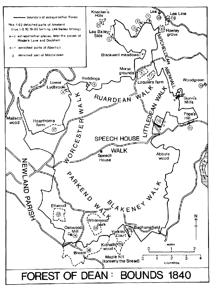
FOREST OF DEAN : BOUNDS 1840
The formerly extraparochial land of the Forest of Dean lies mainly at over 200 m. (656 ft.), reaching its highest point, 290 m. (951 ft.), at Ruardean hill in the north. Sometimes described as a plateau but actually comprising steep ridges and the valleys of streams draining to the Severn and Wye, its boundaries with the surrounding cultivated and ancient parochial lands are in most places defined by a scarp where the underlying carboniferous limestone of the region outcrops. On the west, however, the limestone outcrops at a shallower angle and there is a less obvious distinction in height between the Forest and the cultivated land of the large ancient parish of Newland. The long valley of Cannop brook, earlier called the Newerne stream, (fn. 6) crosses the west part of the Forest from north to south, and a stream called in its northern part Cinderford brook and in its southern Soudley brook forms a long winding valley through the east part. Blackpool brook, so called by 1282, (fn. 7) carves another deep valley through the south-eastern edge of the high land to meet Soudley brook at Blakeney below the Forest's scarp, and at the Forest's northern edge Greathough brook, formerly Lyd brook, (fn. 8) descends a valley to the Wye. The streams were dammed in places for ironworks, notably in the Cannop valley where two large ponds were made in the 1820s to provide power for works at Parkend. (fn. 9) Other large ponds on a tributary stream of Soudley brook at Sutton bottom, near Soudley, were built as fishponds in the mid 19th century for a privately-owned estate in that part of the Forest called Abbots wood. (fn. 10) In the late 20th century the Forestry Commission maintained the Forest's ponds as nature reserves and as a public amenity; new ones were made at Woorgreen, near the centre of the Forest, as part of landscape restoration following opencast coal mining in the 1970s, (fn. 11) and at Mallards Pike, near the head of Blackpool brook, in 1980. (fn. 12)
Geology has given the Forest its rich industrial history. The land is formed of basin-shaped strata of the Carboniferous series. Underlying and outcropping at the rim are limestones which, especially the stratum called Crease Limestone, contain deposits of iron ore. Above are beds of sandstone, shale, and coal. The lowest bed of sandstone is known by the local name of Drybrook Sandstone, and the highest is the Pennant Sandstone. There are over 20 separate coal seams, varying in thickness from a few inches to 5 ft., the highest yielding being the Coleford High Delf which rises close to the surface near the rim of the Forest. (fn. 13) Surface workings, shallow pits, or levels driven into the hillsides were the means of winning the iron ore and coal until the late 18th century when deeper mines were sunk. There were also numerous quarries, notably those in the Pennant Sandstone at Bixhead and elsewhere on the west side of the Cannop valley; that stone, which varies in colour but is mainly dark grey, was the principal building material used in the Forest's 19th-century industrial hamlets.
The Forest was most significant as a producer of oak timber, which was the principal reason for its survival in the modern period. Until the early 17th century, however, there was as much beech as oak among its large timber trees, (fn. 14) and chestnut trees once grew in profusion on the north-east side of the Forest near Flaxley (fn. 15) and gave the name by 1282 to a wood called the Chestnuts. (fn. 16) The underwood was composed of a variety of small species such as hazel, birch, sallow, holly, and alder. (fn. 17) The ancient forest contained many open areas. In 1282 various 'lands', or forest glades, maintained by the Crown presumably as grazing for the deer, included several with names later familiar in the Forest's history, Kensley, Moseley, Cannop, Crump meadow, and Whitemead (later a part of Newland parish). Numerous smaller clearings called 'trenches' had also been made (fn. 18) as corridors alongside roads for securing travellers against ambush (fn. 19) or for the grazing and passage of the deer. (fn. 20) Larger areas of waste, or 'meends', such as Clearwell Meend and Mitcheldean Meend, lay on the borders adjoining the manorial lands, whose inhabitants used them for commoning their animals.
Much ancient woodland was destroyed to make charcoal for the iron industry in the 16th and 17th centuries, but the re-establishment of the woods was encouraged by a policy of inclosure begun in the 1660s and designed to produce shipbuilding timber. The policy faltered during the 18th century but in the early 19th century large new inclosures were again formed and planted almost entirely with oak. A few Weymouth pines planted before 1787 (fn. 21) were apparently the first conifers introduced to the Forest, and conifers were widely planted in the 19th century to shelter the young oak plantations. Large plantations of pure conifer were made during the 20th century and threatened to dominate the woodlands before 1971 when a policy of keeping equal proportions of coniferous and broadleaved trees was adopted. In 1994, when the Forest was more thickly planted than for several centuries, it included isolated late 17th-century oaks, park-like areas of early 19th-century oak preserved mainly as an amenity, and large plantations of oak, beech, fir, and spruce managed for commercial purposes. (fn. 22)
Although the royal demesne land was without permanent habitation until the early modern period, it was crossed by many ancient tracks, used by ironworkers, miners, and charcoal burners; large numbers, many termed 'mersty' (meaning a boundary path), were recorded in 1282 in a perambulation of the Forest bailiwicks, its administrative divisions. (fn. 23) One of the more important ancient routes, known as the Dean road, had a pitched stone surface and borders of kerbstones. It ran between Lydney and Mitcheldean across the eastern part of the demesne by way of Oldcroft, a crossing of Blackpool brook, recorded as Blackpool ford in 1282, (fn. 24) and a crossing of Soudley brook at Upper Soudley. The survival of much pitching and kerbing after the road went out of use in the turnpike era, and the possibility that it had linked two important Roman sites at Lydney and Ariconium, in Weston under Penyard (Herefs.), has led to the suggestion that it was a Roman road, (fn. 25) though much of the stonework probably dates from the medieval and early modern periods; an estimate was made for renewing long stretches of the road, including the provision of new border stones, as late as the 1760s. (fn. 26) Much remained visible in the 1930s, but recent damage by timber wagons and other vehicles was recorded then (fn. 27) and continued later. A short stretch near Blackpool brook, (fn. 28) including part of a side branch across a bridge beside the ford, was preserved and open to view in 1994.
Two main routes crossed the extraparochial Forest from north-east to south-west and on them were sited the principal points of reference in a terrain with few landmarks. A route from the Severn crossing at Newnham to Monmouth recorded in 1255, when 'trenches' were ordered to be made beside it, (fn. 29) was presumably that through Littledean, the central Forest, and Coleford. It entered over a high ridge west of Littledean, where a hermitage of St. White had been founded by 1225, (fn. 30) and crossed Soudley (or Cinderford) brook at the place called Cinder ford in 1258, (fn. 31) long before its name was taken by the principal settlement of the extraparochial Forest that formed on the hillside to the north-east of the crossing. Further west, near the centre of the Forest, the road passed the clearing called Kensley, where a courthouse stood by 1338 close to the site of the later Speech House, (fn. 32) and crossed Newerne (or Cannop) brook at Cannop, which for a few years in the mid 17th century was the centre of a large private estate established within the Forest. (fn. 33) The road emerged into the cultivated land of Coleford tithing at a place later called Broadwell Lane End, where a tree called Woolman oak in 1608 (fn. 34) was probably the 'W(o)lfmyen' oak which in 1282 was a landmark at the boundary of four of the Forest's bailiwicks. (fn. 35) The other main route, recorded in 1282 as the high road to Monmouth, (fn. 36) was that crossing the high north-western part of the extraparochial land from Mitcheldean, by way of Nailbridge, Brierley, Mirystock, where it crossed a tributary of Cannop brook above Lydbrook, to Coleford. The two remained the principal routes through the Forest but the northern one, described in the 1760s as the great road through the Forest from Gloucester to South Wales, was much altered in its course by later improvements. (fn. 37)
The rivers Severn and Wye played a vital role in the development of Dean's industry but few of the various tracks and hollow ways that led from the central Forest to riverside landing-places and ferries were usable other than by packhorses before the 19th century. One of the few routes negotiable by wagons and timber rigs was the central main road out to Littledean with its branch down to Newnham; that was the usual route for carrying timber out of the Forest in 1737 when the Crown was asked to assist Newnham parish to repair part of it. (fn. 38) Later in the 18th century a road leading from the south part of the woodlands by way of Parkend and Viney Hill to Gatcombe and Purton on the Severn became the principal route for timber destined for the naval dockyards. (fn. 39) The repair of the roads, which was the responsibility of turnpike trustees from 1796, and the development of a network to serve the new Forest settlements are discussed below, (fn. 40) as are the tramroads and railways which were built in the 19th century to serve the Forest's industry. (fn. 41)
The Crown's hunting rights, which provided the original motive for the Forest's preservation, were much used in the 13th century. The frequent orders made at the period for taking deer for gifts by the Crown and to meet the needs of the royal household suggest that fallow deer were the majority species in Dean, with red deer and roe present in smaller numbers. (fn. 42) In 1278 the Forest was sufficiently well stocked for royal huntsmen to take 100 fallow bucks. (fn. 43) At that period all three species of deer were classed as beasts of the forest, reserved for the exclusive use of the Crown, but roe were not classified as such after 1340. (fn. 44)
During the 17th century felling of the woods reduced the numbers of deer. The reafforestation Act of 1668, referring to a possible 'restoration' of the king's deer, set an upper limit of 800 animals, so as not to threaten the new inclosures made for navy timber. (fn. 45) Preservation of the deer remained a role of the re-invigorated Forest administration following the Act, (fn. 46) and lax administration during the 18th century allowed poaching to reduce the numbers. In 1751 the scarcity of the deer made advisable a three-year moratorium on taking venison under royal warrants. (fn. 47) In 1788 the keepers estimated that the woods contained c. 500, (fn. 48) but twenty years later there were said to be hardly enough to meet the Crown's usual annual demand of 4 bucks and 4 does. (fn. 49) Tighter administration introduced then to protect extensive new plantations encouraged an increase by 1839 to c. 800 and, in spite of losses in the hard winter of 1840-1, c. 600 remained in the late 1840s and 20 or 30 a year were killed under warrant. In 1849 the Crown Commissioners of Woods ordered the destruction of the deer, on the grounds of the 'demoralizing effects' on the local population of the opportunities for poaching, and all, or almost all, were killed before 1855. At the beginning of the 20th century, however, a small herd of fallow lived in Highmeadow woods, a large Crown estate adjoining the Forest, possibly descendants of some given to the Crown in 1846 and released there; (fn. 50) by mid century another herd had become established in the centre of the Forest woodland, near the Speech House. In 1969 there were c. 65 animals in the Highmeadow herd and c. 50 near the Speech House, (fn. 51) and c. 250 fallow deer grazed the Forest and adjoining woodlands in 1994. (fn. 52)
Of the other beasts of the forest, wild boar were numerous in Dean in the early Middle Ages, with, for example, 100 boars and sows ordered for a Christmas feast in 1254. (fn. 53) Boar still roamed the Forest in the 1280s, like the deer a prey both of royal huntsmen and poachers. (fn. 54) In 1282 eyries of falcons and sparrowhawks were among the perquisites claimed by woodwards of several Forest bailiwicks, (fn. 55) and there were eyries of goshawks in the woods in 1565. (fn. 56) Some traditional nesting places were lost by the indiscriminate felling of great trees in the early and mid 17th century, including eyries reserved for the king's use in a wood called the Bourts, at the northern rim of the demesne above English Bicknor, (fn. 57) but peregrine falcons continued to nest later in cliffs above the Wye adjoining the Forest near Symonds Yat. (fn. 58) Until the 1280s or later the Forest's woods sheltered packs of wolves. (fn. 59)
The commoning of pigs, sheep, and cattle in the royal demesne land of the Forest is described below as an integral, and often contentious, part of the story of the Forest's administration and management. (fn. 60) From the mid 18th century encroachment of land on the fringes of the royal demesne created numerous smallholdings. Their occupants, often miners or quarrymen, pastured sheep on the Forest waste and worked small arable plots, gardens, and orchards. In 1896 in the parishes of East and West Dean, in which most of the formerly extraparochial Forest land was then included, 338 occupiers of land were returned. They held a total of c. 2,200 a., including 416 a. of arable, mainly growing potatoes and oats, turnips, and other fodder crops, and 163 a. of orchard; their stock was 6,514 sheep, 379 cattle, and 590 pigs. (fn. 61) The sheep were part of a larger number in the Forest, where a survey found 10,851 in 1898, (fn. 62) though sheep were of dubious legality and were commoned only on sufferance of the Forest authorities until 1980 when a limit of 5,000 was accepted. (fn. 63) In 1926 when 222 occupiers of land in East and West Dean made returns only 14 had more than 20 a. (fn. 64) The few larger farms included some, like Hoarthorns farm, near English Bicknor, and Loquiers farm, near Drybrook, in former detached parts of Newland that had been added to the two parishes. In the late 20th century smallholdings, usually worked part-time, were still characteristic of the cleared and settled area on the Forest fringes, (fn. 65) and the commoners' sheep, roaming the wastes and roadside verges, remained a familiar feature of the Forest scene.
The history of the royal demesne land of the Forest of Dean in the Middle Ages is that of the administration established to enforce the forest law in defence of the vert and venison and of the mining and ironmaking industries. The administration operated in its fullest form between the late 12th century and the early 14th, a period when it had jurisdiction over a wide tract of manorial and parochial land as well as the royal demesne. It was centred on St. Briavels castle and manor, headed by a royal appointee of considerable standing who was styled constable of St. Briavels castle and warden of the Forest of Dean, and staffed by various categories of foresters, the principal ones holding office by tenure of surrounding manors. The forest system was enforced by an attachment court, presided over by verderers, and by the regular forest eyres with their wide judicial and investigative functions. Even with the full apparatus of a royal forest in place, however, there was corruption by officials and much poaching and timber stealing by local inhabitants. Mining, which in the Middle Ages was mainly for iron ore, and the associated ironmaking industry were anciently established in Dean. A body of mining law, codified in the 13th or 14th century, and protected, enforced, and amended by a mine law court and a Crown-appointed gaveller, restricted the digging, carrying, and sale of ore, coal, and stone to the 'free miners' of St. Briavels hundred. By the 13th century the mines and numerous charcoal pits supplied and fuelled small bloomery forges, which were moved from place to place in the woodlands of the royal demesne and surrounding parishes; the inefficient working of the bloomeries left a legacy of mounds of 'cinders' (slag rich in ore) to be reprocessed later by the water-powered blast furnaces, first introduced to surrounding parishes in the late 16th century.
In the early modern period the Forest administration's basic aim shifted from the defence of the royal hunting rights, and the associated gathering of revenue in the form of fines on offenders, to the preservation and management of the woods for shipbuilding timber. As a result it came into conflict even more markedly with the ironworkers and miners who needed wood for charcoaling and for shoring mines, with the larger numbers of local inhabitants who claimed, and jealously guarded, the right to pasture animals on the demesne, and with squatters who established themselves there in makeshift cabins and stole wood for a variety of trades. The later history of Dean had a cyclical pattern: the pressures tending to the destruction of its woods gained ground in times of weak and inefficient administration and were restricted again in times when the government pursued determinedly its aim to preserve the Forest as a nursery of timber.
In the early 17th century the Stuart kings, seeking short-term profit from their assets, allied themselves with the destructive forces. From 1612 they allowed ironmasters to set up furnaces and forges on the demesne and assigned to them a large annual quota of coppice wood and offal wood for charcoaling; the exercise of those concessions was accompanied by embezzlement of wood, the introduction of cabiners to the demesne, and, though great trees were supposed to be preserved, the destruction of much potential shipbuilding timber. Charles I leased or sold large parts of the demesne in the 1620s. At the same time his search for revenue led him to reimpose the forest law on the local inhabitants in its full rigour by an eyre in 1634. His policy culminated in the sale of the bulk of the demesne to Sir John Winter of Lydney in 1640 but the Long Parliament's assault on the royal prerogative made that arrangement short lived. In the Civil War local royalists, led by Winter, contested control of the Forest and surrounding parishes with the parliamentary garrison at Gloucester. There were numerous skirmishes in the Forest area and some larger incursions, including the advance of Welsh levies against Gloucester under the command of Lord Herbert in February 1643 and the arrival of a destructive force under Prince Rupert in the spring of 1645. (fn. 66) Following the war, with the forest administration enfeebled by the sanctions imposed on the royalist gentry, a group of army officers took control of the ironworks and did further damage to the woodlands.
Under the Protectorate the Forest was more efficiently administered, and after the Restoration Charles II's government, committing itself to a policy of preservation to raise ship timber, inclosed over half the demesne under an Act of 1668, removed the ironworks and illegal squatters, and added more effective elements to the cumbersome administrative apparatus. During the 18th century, however, governmental control was relaxed and the local administration, vitiated by a system of fees which put a premium on abuse and neglect, allowed wood stealing and encroachment to become rife. Squatters began to establish hamlets around the fringes of the demesne, which contained almost 600 dwellings by 1787. The new settlers lived in primitive conditions in roughly-built cottages, and evangelical clergy and nonconformist preachers, who began to minister to them c. 1800, equated the task with missions to the heathen. Three Anglican churches built between 1816 and 1822, at Berry Hill, Harrow Hill near Drybrook, and Parkend, were among signs that the new settlements had become accepted as permanent features of the demesne.
A regular supply of good quality timber produced for the naval dockyards from the late 17th-century inclosures encouraged the government to embark on a fresh programme of inclosing and planting at the end of the Napoleonic Wars, and, under the Crown Commissioners of Woods and a long-serving local deputy surveyor, Edward Machen, the efficiency and reputation of the forest administration were restored. The Forest's industry was also transformed in the early 19th century as outsiders invested in it and formed partnerships with local men. Edward Protheroe of Bristol was the most notable of the 'foreign' capitalists at the period, and later the Crawshay family of Merthyr Tydfil (Glam.) played a leading role. Coal mining especially was developed by building tramroads to carry the coal to shipping points on the Severn and Wye and by installing more steam pumps and new equipment to enable mines to be sunk to the deeper and higher quality seams; the iron industry was revived by the introduction of coke-fired blast furnaces, and quarrying was also much expanded. Many of the poorer inhabitants felt threatened by the changes, in their role as free miners by the erosion of the old protective customs and in their role as commoners by the restrictions imposed under the replanting programme. Their antagonism culminated in riots against the new inclosures in 1831. A detailed enquiry into the Forest, begun the following year, led to statutory measures for regulating the mines, regularizing the Foresters' tenure of their cottages and encroachments, and parochializing the Forest.
In the later 19th century and the early 20th the Forest was a complex industrial region, including deep coal mines and iron mines, iron and tinplate works, foundries, quarries and stone-dressing works, wood distillation works producing chemicals, a network of railways, and numerous minor tramroads. The Forest population grew rapidly: Cinderford was laid out in the mid 19th century on a fairly conventional urban plan and Lydbrook, Parkend, and Drybrook became minor centres, but the characteristic form of settlement remained the sprawling hamlets of haphazardly placed cottages on the periphery. There were substantial accumulations on the hillsides above Ruardean on the north side, along the Soudley valley on the east, above Blakeney on the south-east, in the Yorkley and Bream area above Lydney on the south, and in the Lane Ends and Berry Hill areas adjoining Coleford on the west. Altogether the Forest came to contain c. 20 villages and hamlets, and its population rose from 7,014 in 1831 to 26,624 in 1921.
As part of the infrastructure of the new settlements, more Anglican churches were built, and numerous small nonconformist chapels were founded as nonconformity, particularly the fundamentalist Bible Christian and Primitive Methodist sects, gained a firm hold. Education was provided mainly by church schools until the 1870s when a school board, dominated by nonconformists, undertook a major building programme. From the 1870s the need of the new settlements for watersupply and sewerage schemes began to be addressed, and a proper system of minor roads was formed in the early 20th century. The Foresters' origins as illegal squatters and their struggle to defend their commoning and mining rights gave them a strong sense of community, as well as a reputation for surliness and suspicion towards outsiders. Characteristics shared with other British coalfields, such as a devotion to sport, the central role of miners' clubs, and the formation of brass bands, also helped to create a distinct identity.
The demise of wooden navies long before the early 19th-century plantations matured led to a period of uncertainty about the role of the Forest's administration, but its timber later proved of great national value in the two world wars. In 1924 the Commissioners of Woods transferred control to the Forestry Commission, which during the rest of the 20th century managed the Forest, together with large tracts of woodland in surrounding areas, as primarily a commercial enterprise but with increasing stress on the provision of amenities for leisure; in 1994 the two buildings which had played the principal roles in the administration of the Forest both served tourism, the Speech House in the centre as a hotel and St. Briavels castle in an adjoining parish as a youth hostel. The gradual loss of jobs in traditional industries in the 20th century, ending with the closure of the last deep mines in the 1960s, made necessary the provision of new sources of employment, found mainly in surrounding parishes and towns. Those changes and other modern pressures began to dilute the character of the people and, with the reclamation of industrial sites and more intensive planting, soften the appearance of the landscape, though features such as the continuing use of the rights of free miners and commoners and the survival from the old forest administration of the office of verderer helped to preserve the memory of the area's distinctive history. In 1994 enough remained of the traditional character of the Forest of Dean for it to be seen by outsiders and by its inhabitants as very different from the rest of Gloucestershire.