A History of the County of Gloucester: Volume 5, Bledisloe Hundred, St. Briavels Hundred, the Forest of Dean. Originally published by Victoria County History, London, 1996.
This free content was digitised by double rekeying. All rights reserved.
A P Baggs, A R J Jurica, 'Forest of Dean: Bounds of the forest', in A History of the County of Gloucester: Volume 5, Bledisloe Hundred, St. Briavels Hundred, the Forest of Dean, ed. C R J Currie, N M Herbert (London, 1996), British History Online https://www.british-history.ac.uk/vch/glos/vol5/pp295-300 [accessed 1 May 2025].
A P Baggs, A R J Jurica, 'Forest of Dean: Bounds of the forest', in A History of the County of Gloucester: Volume 5, Bledisloe Hundred, St. Briavels Hundred, the Forest of Dean. Edited by C R J Currie, N M Herbert (London, 1996), British History Online, accessed May 1, 2025, https://www.british-history.ac.uk/vch/glos/vol5/pp295-300.
A P Baggs, A R J Jurica. "Forest of Dean: Bounds of the forest". A History of the County of Gloucester: Volume 5, Bledisloe Hundred, St. Briavels Hundred, the Forest of Dean. Ed. C R J Currie, N M Herbert (London, 1996), British History Online. Web. 1 May 2025. https://www.british-history.ac.uk/vch/glos/vol5/pp295-300.
BOUNDS OF THE FOREST
For much of its history the Forest of Dean, using the term in the particular sense of the area subject to forest law, included two distinct sorts of land: on the one hand there was land held by the Crown in demesne, mainly extraparochial and uninhabited woodland and waste, and on the other manorial and private freehold land, mainly cultivated, settled, and formed into parishes.
The extent of the Forest (fn. 1) at the time of the Norman Conquest is uncertain. Domesday Book refers to it only indirectly, though the disposition of the manors which it records in the area enables a rough idea of the late 11th-century extent to be gained. (fn. 2) The only lands referred to in 1086 as being in 'the king's forest' or 'the king's wood' were a group of manors that had gone out of cultivation before the Conquest, two other manors which had been recently placed in the Forest and had apparently been cleared of population, and some isolated parcels of land, also apparently unpopulated. Domesday Book suggests, therefore, that no settled or manorial land was then within the Forest bounds. If that was so, the late 11th-century Forest was confined to an area not unlike its modern bounds, (fn. 3) except that to the north-west and west it bordered the river Wye for much of the river's course between English Bicknor and Brockweir.
To the south-east it was probably confined to the high land away from the river Severn, for the Severn shore between Highnam, near Gloucester, and the confluence with the Wye in Tidenham, near Chepstow, was occupied in 1066 by a string of 25 manors in the nine later parishes bordering the river. On the west the more rugged lands bordering the Wye were much less heavily populated in 1066 and in some areas cultivation had been abandoned. Staunton, opposite Monmouth, 'Whippington', an estate nearby, and possibly a third manor in the same area had reverted to waste by 1066, as also had two manors at a place called 'Brocote', which almost certainly adjoined the Wye in the Forest area and has speculatively been identified with Redbrook. Those manors (then all part of Herefordshire) remained waste in 1086 and four of them were described as 'still in the king's wood'. (fn. 4)
Along the Wye below Ross-on-Wye (Herefs.) the inhabited manors in 1066 were Cleeve (Herefs.), Walford (Herefs.), Ruardean (then Herefs., later Glos.), English Bicknor, Wyegate on the borders of the later parishes of Newland and St. Briavels, St. Briavels, Hewelsfield, Madgett, and part of Tidenham. Of those, Wyegate and Hewelsfield, though acquiring new Norman lords after the Conquest, were placed within the Forest by King William's command before 1086. For neither was owner, tenantry, or current value recorded, only a fishery at Wyegate, (fn. 5) and the implication is that they had been cleared and added to the waste. On the northern edge of the later Forest, from Ross to Highnam, another 10 Herefordshire and Gloucestershire manors existed in 1066, forming a fairly compact wedge of land along and south of the line of the Ross-Gloucester road. The most southerly manor of that area, then called Dean and evidently comprising land in and around the later Mitcheldean parish, was held by the service of custody of the Forest. (fn. 6) In 1086 a yardland in Taynton, some way north of the Ross-Gloucester road, and land at Cleeve, used to raise sheep and produce honey, were both said to be forest land, while woodland in Ross was stated to be in the 'king's enclosure' (defensu regis). (fn. 7) Those references and a mention of woodland adjoining Churcham as being within the bounds of the Forest of Dean c. 1080 (fn. 8) have led to the suggestion that the Forest included detached parcels of woodland and waste north of the main area. (fn. 9)
Between 1086 and 1228 the bounds of the juridical Forest were enlarged to include all the Gloucestershire and Herefordshire manors and villages in an area bounded on the south-east by the Severn from Over bridge, adjoining Gloucester, to the mouth of the Wye, on the west by the Wye from its mouth up to a ford between Goodrich castle and Walford (Herefs.), on the north-west by bounds, mainly trackways, running from the ford by way of Weston under Penyard (Herefs.) and Gorsley to Oxenhall bridge on Ell brook near Newent, and on the north-east by the main road from Newent to Gloucester. (fn. 10) An early stage of that enlargement was evidently the inclusion of the Domesday manors of St. Briavels, English Bicknor, Ruardean, and 'Dean'. Those manors together with the manors of Flaxley, Newland, Blakeney, and Walmore, at Northwood in Westbury, which were formed from the demesne woodland and waste during the 12th century, and the reconstituted manors of Staunton and Hewelsfield later comprised the hundred or liberty of St. Briavels, (fn. 11) which was regarded later as the core of the Forest. About 1245 three other Gloucestershire hundreds, Bledisloe, Westbury, and Botloe, which by then were wholly or partly included in the Forest, were termed 'the three foreign hundreds' in distinction from St. Briavels hundred, (fn. 12) and certain Forest customs relating to mining and quarrying later applied only within St. Briavels hundred. (fn. 13) Whether the enlargement was the work of one of the early Norman kings or of Miles, earl of Hereford, and his son Roger, who ruled the Forest betweeen 1139 and 1154, is not known. It almost certainly dated from before 1154: apart from Hewelsfield, which may not have become part of the hundred until the late 13th century, the inclusion of the manors of St. Briavels hundred was not challenged under the terms of the Charter of the Forest of 1217.
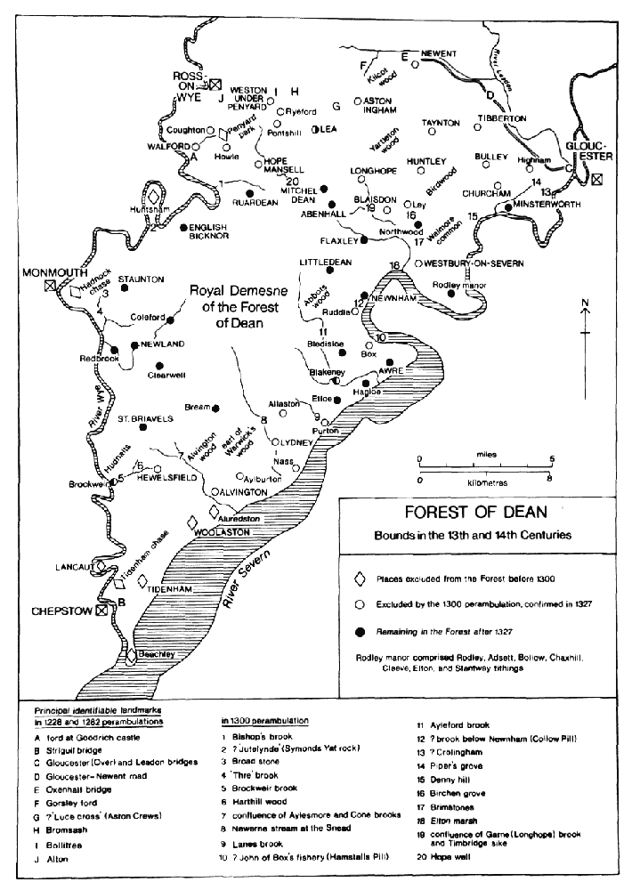
FOREST OF DEAN : Bounds in the 13th and 14th Centuries
The dates of the other extensions are also uncertain, with two perambulations making contradictory statements. A jury stated in 1228 that the wider bounds of the Forest, including all the land between the Severn and Wye and Newent, had been reached before 1154, while in 1300 another maintained that most of the extensions beyond St. Briavels hundred were the work of King John. (fn. 14) There is no definite evidence by which those statements can be judged, but possibly both were incorrect and the extensions were made under Henry II. In 1167, when heavy fines for forest offences were levied in many English counties by the chief justice of the forests, the 19 Gloucestershire places west of the Severn represented were all within the wider bounds of Dean recorded in 1228. The places fined were not necessarily then within the Forest, for some offences, such as poaching and wood stealing, may have been committed elsewhere than in the offenders' own township, but the coincidence and the absence of places outside the wider bounds is suggestive, as is the inclusion on the Gloucestershire list of Hope Mansell (Herefs.) and Hadnock in the lordship of Monmouth, both also within the wider bounds. (fn. 15) A fine in 1199 for waste in woodland within Aylburton provides more definite evidence for the inclusion of a part of Bledisloe hundred by the start of King John's reign. The same year the inclusion of part of Herefordshire and part of Botloe hundred are suggested by a fine on the reeve of Ross for making large assarts from the Forest and by a mention of Walter of Huntley in the capacity of a Forest official, probably a regarder. (fn. 16)
The date of the enlargements later became obscured by the long dispute between the Crown and the barons over forest boundaries and over the implementation of the Charter of the Forest which the barons secured with the reissue of Magna Carta in 1217. By the Forest Charter all land afforested in the years 1154-1216 was to be disafforested unless it was demesne of the Crown at the time of the afforestation. As with other forests, (fn. 17) new perambulations carried out in 1219 appear to have disafforested large areas on those grounds, but in 1227 Henry III, asserting his personal rule and questioning measures taken during his minority, ordered inquiries into those decisions and those who made them. New perambulations to revise the work were ordered, (fn. 18) and in 1228 a jury of knights of Gloucestershire produced a verdict in line with what the Crown expected of them, one that put the wider bounds outside the terms of the Forest Charter. (fn. 19) Although some places effectively became free of the jurisdiction, the wider bounds remained the official bounds of the Forest throughout the 13th century and were confirmed by a perambulation of 1282. (fn. 20) Under baronial pressure, Edward I reissued the Forest Charter in 1297 and ordered new perambulations, one for Dean being made in 1300. In a very different climate from that of 1228 the jury attributed the extensions to King John, though, as suggested above, it is doubtful whether he was responsible; the jurors appear to have produced no documentary evidence for their statement, merely citing local tradition. (fn. 21)
The perambulation of 1300 excluded from the Forest 17 Gloucestershire vills, mostly bordering the Severn or in the north-east, besides the whole Herefordshire part, comprising c. 10 vills in the area between the county boundary and Ross. (fn. 22) The Forest was left as the royal demesne and the parishes of St. Briavels hundred (except for Hewelsfield), together with Minsterworth, the large part of Westbury-on-Severn parish that formed the manor of Rodley, Newnham parish except for Ruddle manor, and Awre parish except for Box manor. (fn. 23) The terms of the Forest Charter appear to have been generally correctly applied, for, of the manors outside St. Briavels hundred that were left within the Forest, Minsterworth, Rodley, Newnham, and Awre were recovered by Henry II from Roger, earl of Hereford, or his brother Walter, in the first years of his reign and remained demesne manors of the Crown until the 13th century. (fn. 24) Edward I confirmed the perambulation of 1300 in 1301. Later, however, he challenged the conclusions of the perambulations made for Dean and other forests and annulled them in 1305. The wider bounds of Dean were reinstated until 1327, when Edward III confirmed the perambulation of 1300. (fn. 25) In the intervening period the return to the wider bounds was more than nominal: Forest officers attempted to restrict the woodland management of the prior of Newent at Yartleton wood, in Newent, (fn. 26) and that of the abbot of Gloucester at Birdwood, in Churcham, and at Hope Mansell. (fn. 27)
During the 13th century some areas, though included within the Forest by the perambulations, had managed to assert their freedom or partial freedom from forest law. Three private chases had been created on the fringes of the Forest by 1228. (fn. 28) The largest was Tidenham chase belonging to the Earl Marshal's lordship of Striguil and covering the parishes of Tidenham and Woolaston in the angle of the Severn and Wye. By the 1260s the limits of the chase, including on the north Brockweir brook running into the Wye and on the north-east Cone brook running into the Severn, were recognized as the de facto Forest boundary by the officers of the Forest, who were principally concerned with the chase as the origin of poaching expeditions into Dean. (fn. 29) The vills in the chase were summoned to the Forest regard of 1282 but failed to appear. (fn. 30) In the enclave that later formed a part of Monmouthshire on the east bank of the Wye, comprising the hamlets of Hadnock and Wyesham, King John granted John of Monmouth, lord of Monmouth, licence to impark part of Hadnock woods. By 1282 the later lords of Monmouth and other landowners in the area had effectively freed themselves from the restrictions of forest law. (fn. 31) Penyard park, on a high wooded hill in the north part of the Forest, in Herefordshire, was a chase of the bishops of Hereford by 1228, and in 1286, when the activities of the bishop's huntsman there were challenged by Forest officers, a jury declared it to be outside the Forest. (fn. 32) The inhabitants of Huntsham tithing (Herefs.), in the loop of the Wye between English Bicknor and Symonds Yat, had also effectively excluded themselves by 1282 when they were reported to have ceased attending inquisitions and eyres. (fn. 33) Exclusion of those four areas had been accepted by 1300 and was confirmed by the new perambulations.
After 1327 there was little or no change in the composition of the Forest until 1597 when Minsterworth parish was excluded. Its inhabitants then cited their membership of the Forest in support of a claim to commoning rights in the demesne woodland, but commoners from the other parishes, who were attempting to exclude their animals, manipulated the evidence and secured a judgement that Minsterworth was outside the Forest. The revised bounds of 1300 had, from Newnham, ascended the Severn as far as a meadow called Crolingham at the boundary of Minsterworth and Highnam and then turned inland to Piper's grove, at the parting of the roads from Gloucester to Ross-on-Wye and Chepstow. Witnesses were found, however, to depose that Crolingham was just above Newnham town and Piper's grove inland from there, near the Newnham-Littledean boundary; the difficulty of connecting the supposed landmarks with what followed in the perambulation was left unresolved. (fn. 34) By 1623 Rodley manor had also ceased to be accepted as part of the Forest, (fn. 35) possibly as a result of the same judgement. Both it and Minsterworth were in the duchy of Lancaster (fn. 36) and on that ground they may earlier have ceased to be subject to some aspects of the Forest jurisdiction.
In 1634 during a forest eyre, held as part of Charles I's attempt to reassert ancient Crown privileges, the justices and royal officials revived the wider bounds of Dean and secured a judgement that the perambulations of 1228 and 1282 were valid. In view of long usage, however, forest offences in the outlying areas were not proceeded with at the eyre, (fn. 37) and an Act of 1641 restored the bounds of all forests to those in accepted use in 1623. (fn. 38) An Act of 1657 lifted the heaviest burdens of the forest law from the manorial lands of Dean, (fn. 39) and an Act of 1668, while confirming the bounds of 1623 and re-applying the forest law to the royal demesne, confirmed the mitigation of the law in the manorial lands; manorial owners and freeholders were subsequently free to fell and manage their woodlands and inclose and otherwise improve their lands as they wished and also to enjoy hunting rights in them. (fn. 40) During the late 17th century and the 18th the bounds of 1623 continued to define the Forest, with, for example, all the parishes of St. Briavels hundred (except Hewelsfield), the bulk of Newnham and Awre, and Northwood tithing, in Westbury, sending representatives to the swanimote. (fn. 41) For practical purposes, however, the Forest administration was then only concerned with the royal demesne, and the demesne was accepted as constituting the Forest in 1833 when the Dean Forest commissioners cited the bounds of 1300 but perambulated and reported only on the royal demesne. (fn. 42)
The royal demesne land of the Forest as it existed in the 19th century was the residue of a much larger area of woodland and waste that had been reduced over the centuries by assarting and by royal grants. The earliest and most significant encroachments upon it occurred largely unrecorded during the 12th century. They included the formation from many individual assarts of the bulk of Newland, which gained the status of a separate manor and parish at the start of the 13th century, the creation of Flaxley by a gift of Roger, earl of Hereford, to his foundation Flaxley abbey c. 1150, the reconstitution of Staunton and Hewelsfield, and on the south-eastern fringes of the demesne the emergence of the small manors of Blakeney, added to Awre parish, (fn. 43) Walmore at Northwood, added to Westbury parish, (fn. 44) and probably Blythes Court in Newnham (fn. 45) and Soilwell in Lydney. (fn. 46) The continuing pressure on land in the 13th century is reflected, among other examples, by encroachments on the demesne on the east side of St. Briavels parish, (fn. 47) considerable assarts made by the lords of Littledean, (fn. 48) 180 a. of assart, probably on the hillsides above Newnham, held by the woodward of Blaize bailiwick in 1306, (fn. 49) and, in one of the areas only nominally attached to the Forest, 200 a. assarted from Tidenham chase before 1282 by Tintern abbey (Mon.), owner of Woolaston manor. (fn. 50) In most cases the Crown gave retrospective sanction to the assarts by levying small rents, and it followed a more deliberate policy for all forests in the early 14th century, appointing commissioners in 1303 (fn. 51) and 1313 (fn. 52) to dispose of unwanted land to interested parties at fee-farm rents, and presumably for initial fines. Bearse bailiwick on the west side of the demesne was dismembered at the period, with 212 a. at Prior's Mesne added by Llanthony priory to its Aylburton estate in 1306, (fn. 53) John of Wyesham, constable of St. Briavels, obtaining a substantial estate at Noxon, near Clearwell, in 1317, and John Joce, the woodward of the bailiwick, securing large tracts of land in the same area. (fn. 54)
Detached parts of Newland parish on the fringes of the demesne or forming islands within it (fn. 55) were probably mostly taken out of the demesne between 1305, when the impropriator of Newland church was given the tithes from all recent and future assarts in the Forest, (fn. 56) and the Black Death in 1349, when the era of pressure on land ended. Detached parts near the main body of Newland parish, at Bream, Yorkley, and Ellwood, had certainly been wholly or partly created by the mid 14th century, (fn. 57) and some more distant parts at Lea Bailey, on the Herefordshire border, were recorded from the early 15th century. (fn. 58) Small detached parts at Lower Lydbrook and in the Oakwood brook valley were apparently made in the early 15th century in connexion with the building of mills on parcels of waste. (fn. 59)
An island called Whitemead park, inclosed before 1283 and added to Newland parish, remained in Crown ownership and was sometimes accounted a part of the Forest demesne later. (fn. 60) Abbots wood, covering c. 880 a. on the east side of the Soudley brook valley, also had an anomalous status after the Crown granted it to Flaxley abbey in 1258 quit of forest law but with the herbage, hunting, and mineral rights reserved. The wood later remained the freehold of the owners of the Flaxley estate but for some purposes it was administered with the royal demesne. (fn. 61)
Gifts, sales, and leases made by Charles I in the 1620s effectively disafforested c. 3,000 a. of the royal demesne, and the bulk of the remainder was disafforested when sold to Sir John Winter in 1640, though that sale was rescinded in 1642. (fn. 62) The Act of 1668 reafforested the demesne and applied it to producing timber for the navy and most of the alienated lands were recovered, (fn. 63) but woods called the Snead and Kidnalls, covering c. 280 a. near Lydney, and Mailscot, c. 800 a. on the north-west of the demesne between English Bicknor and Staunton, remained outside the Forest and became parts of the Lydney and Highmeadow estates respectively. (fn. 64) Although severed from the royal demesne, the Snead, Kidnalls, and Mailscot remained extraparochial land until parochialized with the demesne in 1842. (fn. 65)
In 1668 the surviving royal demesne land was estimated at c. 23,000 a., (fn. 66) and in 1788 it was surveyed as 23,250 a. (fn. 67) Its main portion was by then confined to the higher ground at the centre of the old Forest area. On the north, east, and south its bounds mostly followed steep ridges, but the boundary with the Wyeside parishes to the west was less clearly defined by the lie of the land. The chief irregularities in the shape of the main part of the demesne, apart from the islands of Newland parish within it, were to the north, where a spur included the Lea Bailey woods on the Herefordshire boundary, and on the north-west, where, following the exclusion of Mailscot wood, a narrow strip of waste extended along the road from Berry Hill to Symonds Yat rock. Detached parts of the royal demesne were Walmore common (240 a. in 1788) and a small parcel called Northwood green, both within Westbury, Hudnalls covering c. 1,200 a. above the Wye Valley adjoining St. Briavels and Hewelsfield parishes, Bearse common, the Fence, and Mocking Hazel wood, within or adjoining St. Briavels, and the Glydden, within Newland parish near Lower Redbrook. (fn. 68)
The royal demesne was further reduced in 1827 when the Crown sold its rights in Hudnalls, which was by then much encroached, Mocking Hazel, and the Fence. (fn. 69) In 1869 it sold its rights in Abbots wood, which was disafforested under an inclosure award of 1872; (fn. 70) the freehold was bought back by the Crown in 1899. (fn. 71) In 1871 when the Crown inclosed the bulk of Walmore and Bearse commons both were disafforested. (fn. 72)
From the mid 18th century encroachments by cottagers removed from Crown control other land on the fringes of the central block of royal demesne, where new hamlets were formed. In 1838 the Crown conceded ownership of encroachments made before 1787 and later sold many others to the occupants; (fn. 73) by 1874 2,100 a. had been removed from the demesne in that way. During the later 19th and the 20th centuries the Forest of Dean still constituted the whole 23,000-24,000 a. of the former royal demesne, but the land that was owned by the Crown and administered by the Commissioners of Woods, mainly inclosed timber plantations and commonable waste, was restricted to c. 19,200 a. by 1874, (fn. 74) and the area transferred to the Forestry Commission in 1924 was 19,347 a. Highmeadow woods, on the north-west of the Forest, bought by the Commissioners of Woods in 1817, and other local woodlands acquired by the Forestry Commission in the 20th century were administered with Dean but not part of it. (fn. 75)