A History of the County of Middlesex: Volume 5, Hendon, Kingsbury, Great Stanmore, Little Stanmore, Edmonton Enfield, Monken Hadley, South Mimms, Tottenham. Originally published by Victoria County History, London, 1976.
This free content was digitised by double rekeying. All rights reserved.
A P Baggs, Diane K Bolton, Eileen P Scarff, G C Tyack, 'Kingsbury: Introduction', in A History of the County of Middlesex: Volume 5, Hendon, Kingsbury, Great Stanmore, Little Stanmore, Edmonton Enfield, Monken Hadley, South Mimms, Tottenham, ed. T F T Baker, R B Pugh (London, 1976), British History Online https://www.british-history.ac.uk/vch/middx/vol5/pp49-55 [accessed 30 April 2025].
A P Baggs, Diane K Bolton, Eileen P Scarff, G C Tyack, 'Kingsbury: Introduction', in A History of the County of Middlesex: Volume 5, Hendon, Kingsbury, Great Stanmore, Little Stanmore, Edmonton Enfield, Monken Hadley, South Mimms, Tottenham. Edited by T F T Baker, R B Pugh (London, 1976), British History Online, accessed April 30, 2025, https://www.british-history.ac.uk/vch/middx/vol5/pp49-55.
A P Baggs, Diane K Bolton, Eileen P Scarff, G C Tyack. "Kingsbury: Introduction". A History of the County of Middlesex: Volume 5, Hendon, Kingsbury, Great Stanmore, Little Stanmore, Edmonton Enfield, Monken Hadley, South Mimms, Tottenham. Ed. T F T Baker, R B Pugh (London, 1976), British History Online. Web. 30 April 2025. https://www.british-history.ac.uk/vch/middx/vol5/pp49-55.
KINGSBURY
Kingsbury (fn. 1) was a small parish, estimated in 1831 as 1,700 a., (fn. 2) which lay west of Edgware Road, about 6 miles from London. The river Brent formed its southern boundary with Willesden and it was separated from Harrow on the west by the Lydding brook and Honeypot Lane. The eastern boundary, with Hendon, was formed by Edgware Road as far as the Hyde, where it turned west along Kingsbury Road and then south along field boundaries and a road to the Brent. The northern boundary, with Little Stanmore, does not seem to have been fixed until after 1276-7, when Colmans Dean was regarded as part of Stanmore Chenduit manor. (fn. 3) In 1536 the inhabitants of Kingsbury were presented at the manor court for not having any marked boundaries. (fn. 4)
The civil parish of Kingsbury formed part of Wembley U.D. from 1894 until 1900, when it became Kingsbury U.D. In 1934 Kingsbury (then 1,829 a.) and Wembley were again combined in Wembley U.D., later a municipal borough, and minor changes were made in the boundaries with Harrow and Willesden; there were further adjustments in 1938 when the course of the river Brent was altered. (fn. 5) In 1965, under the London Government Act of 1963, Wembley merged with Willesden in the London Borough of Brent, of which Queensbury, Kingsbury, and Chalkhill wards covered approximately the area of the former parish of Kingsbury. (fn. 6)
Almost the whole of Kingsbury is composed of London Clay. There are small deposits of Boyn Hill Gravel at St. Andrew's church and Blackbird Hill, just north of Kingsbury bridge, and of glacial gravel on the Hendon border, north of Wood Lane. There are strips of alluvium along the course of the river Brent and Lydding brook, and some Taplow Gravel where they meet in the south-west corner of Kingsbury. (fn. 7) The London Clay gives most of Kingsbury an undulating landscape of between 100 ft. and 200 ft. Barn Hill in Wembley Park (Harrow parish) sends two tongues of higher land into western Kingsbury, at Hill Farm and just north of Forty Lane. There are hills near Bush Farm, Wood Lane, Redhill, and Wakemans Hill Avenue in central Kingsbury where the land rises to its highest point, 302 ft. (fn. 8)
In north Kingsbury tributaries of the Lydding brook flow westward while tributaries of the Silk stream flow to the east. Southern Kingsbury is drained by two tributaries of the river Brent. One flowed from Kingsbury Green and entered the river to the east of St. Andrew's church; the other rose near Hill Farm and followed Salmon Street, joining the river to the west of the church. (fn. 9) Flooding was always a problem in the south especially after the building of Brent reservoir in 1835-9. (fn. 10) There were serious floods in 1841, (fn. 11) and as late as 1932 Salmon Street and the surrounding fields were under water. (fn. 12)
Among those who lived in Kingsbury were two servants of Elizabeth I and James I. Thomas Scudamore (d. 1626), described in 1596 as one of the queen's yeomen, (fn. 13) lived in Brasiers at Kingsbury Green. John Bull (d. 1621), gentleman of the poultry, probably lived at Roe Green. Both men were buried in St. Andrew's church. (fn. 14) A contemporary, John Chalkhill (fl. 1600), the poet and friend of Edmund Spenser, may have lived at Chalkhill House. (fn. 15) The head of Chalkhill House at the time was called Jon or Eyan Chalkhill (d. 1605), and he was succeeded by a son of the same name, (fn. 16) but there was a John Chalkhill of Kingsbury in 1606 (fn. 17) and it is possible that the poet was a younger son or that the later generation which published his work misinterpreted the name Jon. The most famous of Kingsbury's residents was Oliver Goldsmith, who from 1771 to 1774 lodged at Hyde farm-house, where he wrote She Stoops to Conquer and where he was visited by Reynolds, Johnson, Boswell, and Mickle, the translator of the Lusiad. (fn. 18) Just as his walks 'about the hedges' inspired Goldsmith to write his Animated Nature, (fn. 19) so did James Harting, the naturalist who lived at St. Mary's Lodge c. 1851-1876, find most of the material for his Birds of Middlesex in Kingsbury's countryside and especially at Brent reservoir. (fn. 20) Field-Marshal Lord Roberts of Kandahar lived at Grove Park from 1893 until 1895. (fn. 21) Capt. Bertram Mills raised horses at Redhill farm in the early 1920s. (fn. 22) John Logie Baird (d. 1946), the television pioneer, rented the coachhouse and stables at Kingsbury Manor in 1928 and a year later received there the first television signals from Berlin. (fn. 23)
Kingsbury lay between two ancient north-south routes, Watling Street or Edgware Road and Honeypot Lane, earlier called Old Street (fn. 24) or Hell Lane. Edgware Road remained important throughout Kingsbury's history (fn. 25) but Honeypot Lane disappeared as a road between 1597 and 1729-38, (fn. 26) although part of it remained as a footpath. (fn. 27) The other roads in Kingsbury were access roads linking the scattered farms and cottages and mostly converging on Kingsbury Green. One early road ran northward from Roe Green to Little Stanmore church. Its name, Bacon Lane, may have been derived from the Bucointe family, whose estates lay in Little Stanmore and northern Kingsbury in the 12th and 13th centuries, (fn. 28) or from John Bacun, a tenant of Edgware manor in 1284. (fn. 29) Between 1729-38 and 1754 the middle portion of Bacon Lane fell into disuse, leaving a short road, the present Bacon Lane, and a northern road beginning in Kingsbury and continuing into Little Stanmore. (fn. 30) By 1819 the Kingsbury portion of the latter had disappeared altogether. (fn. 31)
Kingsbury was linked to Harrow by Forty Lane, known in 1597 as Wembley Lane, (fn. 32) and by Gore or Kenton Lane. John Lyon (d. 1592), whose lands bordered the latter, left a bequest for the repair of the road which he described as between Goreland Gate and Hyde House; (fn. 33) payments of £2 for that purpose were still being made by Harrow School to the highway board in the later 19th century. (fn. 34) The payments were inadequate, however, and in the 1770s Oliver Goldsmith lost his shoes 'stuck fast in a slough' there, on his way to visit his friend, Hugh Boyd, at Kenton. (fn. 35) Kenton Lane was widened in the 1880s (fn. 36) but its condition was very bad at the beginning of the 20th century, mainly because of the activities of Dr. Arthur Calcutta White and his lessee at Gore Farm. (fn. 37) The road was covered with tarmac in 1912 (fn. 38) and widened and straightened as Kingsbury Road in the 1920s. (fn. 39)
In 1597 many roads converged on Kingsbury Green. One, originally called Ox Street or London Lane (fn. 40) and later Kingsbury Road, ran eastward to the Hyde; Buck Lane, earlier known as Stonepits or Postle Lane, (fn. 41) ran northward from Kingsbury Green to join Hay Lane, a road mentioned in the 13th century. (fn. 42) Another early road in northern Kingsbury was Tunworth or Stag Lane, which ran from Redhill to Roe Green. (fn. 43) Church Lane, in 1563 called Northland Lane, (fn. 44) ran southward from Kingsbury Green to the church and Green Lane (fn. 45) joined the green to Townsend Lane, known as North Dean Lane in 1394 and 1503. (fn. 46) On the west Gibbs or Piggs Lane (fn. 47) joined Kingsbury Green to Slough Lane or Sloe Street, as it was called in 1428. (fn. 48) The southward extension of Slough Lane, Salmon Street, was called Dorman Stone Lane in the 15th and 16th centuries. (fn. 49) The portion of road between the Brent and the junction of Salmon Street and Forty Lane, now called Blackbird Hill, was usually known as Kingsbury Lane. (fn. 50) There was an east-west road joining Hill and Freren farms to Hendon. The portion between Church Lane and Salmon Street, called Freren Lane in 1379, (fn. 51) had disappeared by the early 18th century. (fn. 52) That between Townsend Lane and Hendon, known as Wadlifs Lane in 1574, (fn. 53) survives as Wood Lane.
Green Lane, Gibbs Lane, and Freren Lane, as well as Honeypot Lane, fell into disuse between 1597 and 1729-38, (fn. 54) as did part of Bacon Lane soon afterwards. Thereafter for almost two centuries there was little change, in spite of frequent complaints that there were too many miles of road for a small population to keep in repair. (fn. 55) The very bad state even of Edgware Road is reflected in the bequests for repairs made by 16th-century parishioners (fn. 56) and in the name Deadman Slough, which was applied to the central portion of the road in 1597. (fn. 57) In 1851 it was pointed out that the church was isolated by dirty and sometimes flooded roads, (fn. 58) a problem still much in evidence during the heavy storms of 1903. (fn. 59) Heavy traffic along Stag Lane in connexion with the aircraft industry led to an improvement in the road there in 1917. (fn. 60) The most important factor, however, in the transformation of Kingsbury's quiet country lanes into wide and busy thoroughfares was the opening of the British Empire Exhibition at Wembley Park in 1924. To provide access to it Blackbird Hill, Forty Lane, Kenton Lane, and Church Lane were widened and straightened. (fn. 61) In 1926 work began on a new north-south road to follow the route of the ancient Honeypot Lane. (fn. 62) By 1935 Kingsbury had been covered by a network of suburban roads, although most of the old roads survived. (fn. 63)
From ancient times the river Brent had probably been crossed at Blackbird Hill, the point where Salmon Street crosses the river. The road and bridge were mentioned in 1531 and in 1596 there was said to have been a footbridge there from time immemorial. Responsibility for its repair was divided between the lords of Kingsbury and Neasden manors. There was a ford next to the bridge for horses and carts, except when the river was in flood when the footbridge might be used by horses. Jon Chalkhill's water-mill (fn. 64) caused the formation of a large pool which submerged the ford. All Souls College built a bridge strong enough to take horses and carts and agreed with Chalkhill that he would repair it as long as he retained his mill. (fn. 65) Responsibility probably reverted to the college during the 17th century, (fn. 66) and in 1824 Kingsbury vestry asked it to repair or rebuild the bridge. (fn. 67) It is not known whether the bridge was repaired then but in 1826 it was described as wooden and 11 ft. wide, spanning a river 33 ft. wide and 6 ft. deep. (fn. 68) A new bridge was built in 1922 as part of the changes connected with the British Empire Exhibition. (fn. 69)
The bad state of the roads kept Kingsbury comparatively isolated although coach services passed along Edgware Road. (fn. 70) Trams ran along Edgware Road in 1904 (fn. 71) but bad roads prevented the opening of a motor-bus service from Golders Green to Harrow along Kingsbury Road in 1920. (fn. 72) Week-end services along Kingsbury Road, Kingsbury Lane, and Forty Lane were introduced by the London General Omnibus Co. Ltd. in 1925, mainly as a result of the British Empire Exhibition. (fn. 73) More buses followed the improvement of roads and suburban building development until by 1934 most of Kingsbury was adequately served. (fn. 74)
The railway came late to Kingsbury. The Metropolitan Railway line was built across the south-western corner in 1880 and a station was opened at Wembley Park near the WembleyKingsbury border in 1894 but it had little effect upon the parish until the 1920s. (fn. 75) In 1932 the Stanmore branch of the Metropolitan line, which in 1939 became part of the Bakerloo line, was built across western Kingsbury and stations were opened at Kingsbury in 1932 and at Queensbury in 1934. (fn. 76)
It is possible that Kingsbury was settled before the Anglo-Saxon period. Bronze-age cinerary vessels have been reported from Brent reservoir (fn. 77) but they could have been washed some distance by streams. Roman bricks and hypocaust tiles in the fabric of old St. Andrew's church and alongside Salmon Street probably came from somewhere in the close vicinity. Roman pottery has been found inside the churchyard and in Old Church Lane; although bricks and tiles might have been brought some distance it is improbable that small sherds of pottery would have been of interest to the builders of the church. (fn. 78) William Stukeley's identification of Kingsbury churchyard with Caesar's camp (fn. 79) is entirely fanciful, possibly based upon the configuration formed by rubble from a disused sand-pit. (fn. 80)
Settlers probably reached Kingsbury along the valley of the Brent and by Watling Street. Early settlement was on the two outcrops of Boyn Hill Gravel in southern Kingsbury, which provided well-drained but water-bearing sites of light vegetation in the midst of the dense forest cover of the London Clay. Kingsbury, unlike neighbouring Harrow, was never an area of nucleated villages; the forest was probably gradually cleared from isolated farms, one of the earliest of which was Tunworth or Tuna's farm at Redhill. (fn. 81)
The settlement pattern in the Middle Ages was probably even more scattered than it was later. Most of the 21 tenements or messuages held from Edgware manor in 1426 (fn. 82) were in existence in the 13th and 14th centuries. (fn. 83) A northern group included Groves in Stag Lane, Seakins, and Roes on either side of Hay Lane, and Hillhouse at Roe Green. There was a group around Kingsbury Green - Randolfs, Gardiners, Masons, Wilkin Johns, and Jack Johns. Hamonds, on the site of the later Hyde farm-house, and Perrys at Townsend Lane were in the east, and there was another group along the northern part of Salmon Street. There was a house called Lewgars at Slough Lane from the 13th century until c. 1952. (fn. 84) Dibbels probably stood opposite it, on the south side of Slough Lane. On the west side of Salmon Street stood Richards, Warrens, Edwins, and Dermans.
There were at least 12 holdings of Kingsbury manor, to most of which a messuage was attached in the 13th and early 14th centuries. (fn. 85) Most of these houses probably lay between Chalkhill Place and Kingsbury church. (fn. 86) The settlement was decimated by the Black Death. In 1350 the deaths of at least 13 people 'at the time of the pestilence' were presented at Kingsbury manor court after which the property became concentrated in the hands of survivors, leaving the houses to decay. (fn. 87) Elsewhere the disaster probably caused the abandonment of most of the tenements in Salmon Street. Presentments for not repairing dilapidated houses, 'for fear of disease', continued throughout the next two centuries. (fn. 88) Although Kingsbury recovered, the pattern of settlement was never the same again. Southern Kingsbury shrank from a village to a church and one or two farms. The most populous area was Kingsbury Green, which grew as new houses were built there during the 15th and 16th centuries.
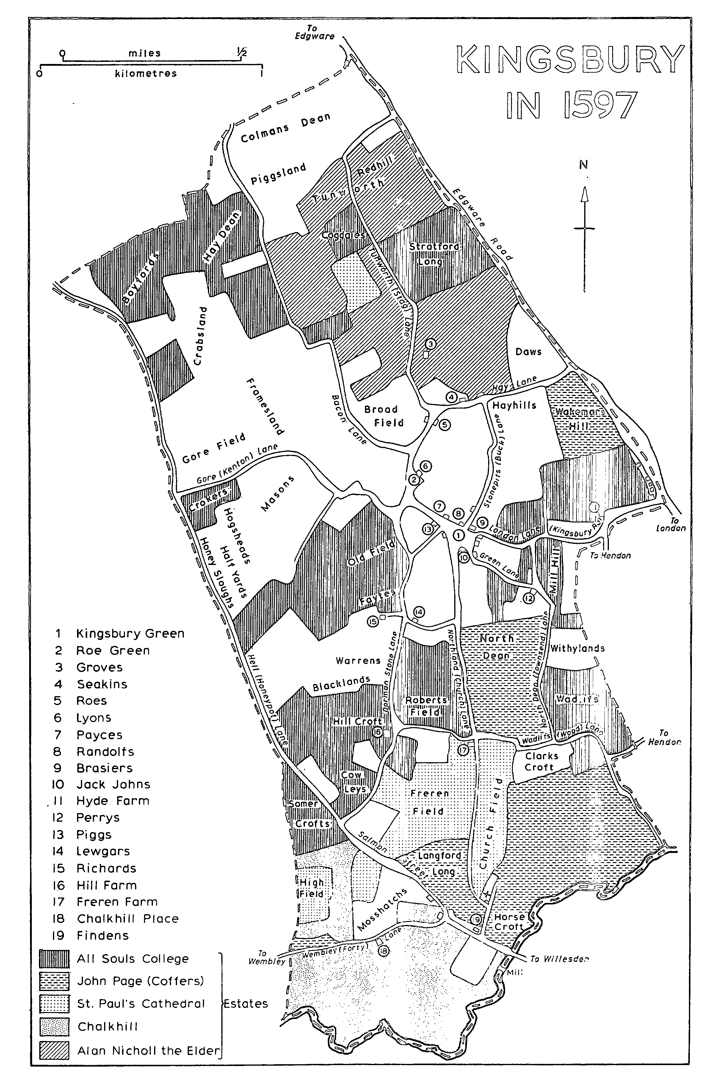
KINGSBURY IN 1597
The Hyde, another area of settlement, first appears as a surname in the 13th century, (fn. 89) although there is no evidence of any dwellings there before the 16th century. Edgware Road, bordered by dense woods infested with brigands and the scene of frequent violence during the 13th century, (fn. 90) was not likely to attract settlement. The first cottage was built on the waste at the Hyde in 1556-7. Another was built next to it in 1574-7 and a third in 1590-1. (fn. 91)
By 1597 there were 5 cottages at the Hyde and 26 houses in the rest of Kingsbury, although there may also have been labourers' cottages attached to some of the larger farms. (fn. 92) Fifty-two houses were listed under Kingsbury for the hearth-tax assessment of 1664. (fn. 93) In 1801 there were 45 inhabited and 5 uninhabited houses. (fn. 94) Maps show few topographical changes between 1597 and 1800. (fn. 95) Pasture had increased at the expense of arable and much woodland had been cleared but thick hedges still conveyed a wooded appearance. There had been little change in the pattern of settlement beyond the growth of the Hyde, where new houses and cottages had been built in 1675, 1684, and 1752, (fn. 96) one of them probably Shell Cottage at no. 44 Kingsbury Road, which was still there in 1971. (fn. 97)
Kingsbury's growth during the 19th century was erratic. The population trebled between 1801 and 1851 and the number of inhabited houses increased from 45 to 102. By 1881 there were 142 houses, yet in 1901 there were only 140 inhabited houses. (fn. 98) The pattern of settlement remained much the same. Apart from the scattered farms and their attendant labourers' cottages, most housing was concentrated around the two ancient greens, Kingsbury Green and Roe Green, and the Hyde. A new centre was Pipers Green, situated to the west of Kingsbury Green at the junction of Kenton Lane with Slough Lane. The name, which may have been derived from John Lyon, piper, who was mentioned in 1422, (fn. 99) was taken from a close called Pipers. A building, probably Pipers Farm, was erected next to Slough Lane between 1597 (fn. 100) and 1729-38. (fn. 101) Between 1839 (fn. 102) and 1865 (fn. 103) the Green Man and another house were erected to the west and the National school was built to the north; a smithy and a small group of terraced houses, probably Uxbridge Terrace, (fn. 104) were built on Kenton Lane to the west of Pipers Green. The house on the site of Pipers Farm was, from 1851 until 1880, called Rose Villa. (fn. 105) Another house at Pipers Green was in 1860 called Kingsland Villa. (fn. 106) The villas may have been rebuilt during the late 19th century, and from 1894 (fn. 107) until after the Second World War they were known as Fern Dene, the Glen, and Oakfields. (fn. 108)
Kingsbury unlike its neighbours Harrow and Hendon, was never the home of many wealthy or influential people, but each of its hamlets possessed some large villa-residences. In 1816 (fn. 109) there were 'a few residences of an ornamental character' at Kingsbury Green and in 1850 such villas included Kingsbury House and Mount Pleasant, as well as Grove Park, a 'distinguished seat'. (fn. 110) Kingsbury House, situated to the east of Kingsbury Green on the site of the medieval tenement of Wilkin John, (fn. 111) was probably rebuilt in the mid 19th century (fn. 112) and demolished c. 1930. (fn. 113) Mount Pleasant, which stood in Hay Lane on the site occupied in 1597 by Hopcock's cottage, (fn. 114) was demolished in 1926. (fn. 115)
Other houses at Kingsbury Green included St. Mary's Lodge, erected on the site of Piggs tenement between 1839 (fn. 116) and 1851 (fn. 117) and demolished c. 1949, (fn. 118) and Eden Lodge, erected on the site of Collins tenement by 1865 (fn. 119) and demolished in 1967 when the new synagogue was built. (fn. 120) At Roe Green in 1887 Roe Green House and Haydon House were 'pleasant little mansions half-buried in their surrounding foliage'. (fn. 121) Larger houses along Edgware Road included Springfield House, Grove House or Elm Lea, erected between 1839 and 1851 (fn. 122) and, in the north, Redhill House, erected between 1819 (fn. 123) and 1839, which from 1851 was called Oak Cottage or Lodge. (fn. 124)
One of the most striking of the 19th-century houses was Lewgars in Slough Lane. A house stood on the site probably from the 13th century. It was rebuilt in the 18th or early 19th century and enlarged in 1872 with a west wing in a fantastic castellated and ecclesiastical Gothic style by its new owner, Edward Nelson Haxell, a churchwarden and enthusiastic antiquary, who used materials from St. Andrew's church which had been discarded during the restoration of 1870. Lewgars was demolished c. 1952. (fn. 125) In 1899 a large, halftimbered house, designed by W. West Neve, was erected east of Valley Farm for Mary, dowager duchess of Sutherland, the wife of Sir Albert Kaye Rollit, M.P. Called the Cottage, Manor House and, after 1929, Kingsbury Manor, it was acquired by Middlesex C.C. in 1938 and used as an old people's home. (fn. 126)
Until the First World War and, in many parts of the parish, until the 1930s, (fn. 127) Kingsbury impressed outsiders by its totally rural appearance. Oliver Goldsmith wrote in 1771 of his sojourn at Hyde House as being in the country, where he had been strolling about the hedges, and in 1837 his biographer described the prospect from the farm-house of the wooded, undulating country towards Hendon. (fn. 128) A view of the Hyde in 1799 shows a cluster of probably weatherboarded cottages and a wide, rut-marked road with well-wooded verges. (fn. 129) In 1860 the view from Kingsbury church was rural in every direction, (fn. 130) and in 1887 praise was lavished upon Kingsbury's winding lanes overhung by luxuriant foliage, its hayfields and its buildings with their old world look. (fn. 131) Many writers (fn. 132) eulogized southern Kingsbury and Brent reservoir for the wealth of wild life found there.
The reality for most of the inhabitants must have been different, for the parish at that period was characterized by neglect. Its hedges were unkempt because cheap coal had replaced hedge-wood as fuel. (fn. 133) Its many winding lanes, difficult to maintain and a burden on the rates, were frequently uncared for and almost impassable in winter. (fn. 134) Its beautiful reservoir brought destruction to farm-land and death to injudicious bathers. (fn. 135) The small population meant that rates, though high, could not finance essential services and insanitary conditions and illhealth were prevalent. Perhaps the most important cause of neglect was the system of leasing. Almost all the picturesque farms and cottages were held on short leases and often sub-let, which meant that they were rarely in good repair and were frequently overcrowded and squalid. (fn. 136) The building of Holy Innocents church in 1884 was a belated recognition that the main area of settlement was central Kingsbury. From the two new farms, Gore and Valley farms, in the west, houses stretched through Kingsbury Manor, Pipers and Kingsbury greens and the terraced cottages built in Buck Lane in 1843 (fn. 137) to those which were creeping westward along Kingsbury Road from the Hyde; tall, narrow buildings known locally as the windjammers, (fn. 138) they were described in 1934 as 'the ugliest thing in rural Middlesex'. (fn. 139) In contrast, there was little development along Edgware Road itself between 1839 and the First World War, largely because of the difficulties of sewerage and inadequate public transport. (fn. 140)
The First World War and the siting of the British Empire Exhibition at Wembley Park hastened development. The number of houses rose from 140 to 1901 to 440 in 1921, 3,937 in 1931, and 11,776 in 1951. (fn. 141) Work started before the war in Stag Lane, near Edgware Road, where 20 houses were built in 1909-10 and 16 more by 1919. (fn. 142) The 1914-18 war brought the aircraft industry to northeast Kingsbury and in 1916 the Office of Works commissioned Frank Baines to design Roe Green Village for employees of the Aircraft Manufacturing Co. Ltd. He was to build 250 houses on a 24-acre site north-west of Roe Green, between Bacon Lane and Stag Lane; 150 had been built by 1919 but the slump following the war left about 75-90 houses unoccupied in 1920. (fn. 143)
The Metropolitan Railway Co. Estates Ltd., which was largely responsible for the development of Wembley, bought most of the Chalkhill estate in 1919. By 1924 large, detached houses had been built around the new Chalkhill and Barnhill roads. (fn. 144) The widening of Forty Lane and Blackbird Hill to give access to the British Empire Exhibition opened up the whole of southern Kingsbury to the builders and roads and houses to the east of Salmon Street, between Queens Walk and Old Church Lane, were constructed during the early 1920s. (fn. 145) During that period industry was established in Edgware Road and at Kingsbury Works in Kingsbury Road, (fn. 146) and 37 council houses were built at High Meadow Crescent near Kingsbury Green. (fn. 147)
Most development, however, took place in the late 1920s and early 1930s. From 1931 until 1933 houses were being erected at a rate of over 1,000 a year, mostly by private firms, (fn. 148) some of which, like Kingsbury Estates Ltd. (1925), (fn. 149) Salmon Estate (Kingsbury) Ltd. (1928), (fn. 150) Kingsbury Development Co. Ltd. (1934), (fn. 151) and Woodfields Development Co. Ltd. (1936), (fn. 152) were set up expressly to develop Kingsbury. Most of the housing in the area enclosed by Edgware Road, Stag Lane, and Roe Green was built after 1926 and complete by 1935. (fn. 153) In the south planning permission was granted for building near Wood Lane in 1926; (fn. 154) 108 houses were being built on Townsend Park estate in 1926, the council built 63 houses in Elthorne Road and Way in 1927-31, (fn. 155) and plans were submitted for 116 houses on Fryent Farm estate in 1928. (fn. 156) Shop sites and building land in Church Lane were being offered for sale in 1933 (fn. 157) and building was taking place along Salmon Street in 1934. (fn. 158) By 1935 houses filled the area east of Salmon Street and south of Lavender Avenue, and much of that between Forty Lane on the south and Salmon Street on the north-east. (fn. 159) The farm-lands of Gore farm and Hungry Down were sold in 1928 (fn. 160) and 1931 (fn. 161) respectively but growth in north-west Kingsbury really began with the construction of the Underground railway and opening of stations at Kingsbury and Queensbury in 1932 and 1934 and with the widening of Kingsbury Road in the 1920s and building of Honeypot Lane in 1934. (fn. 162) In 1932 development extended on either side of Kingsbury Road, along Valley Drive and some of its side streets to the south, and northward as far as Girton Avenue and Fairway Avenue. (fn. 163) Stag Lane airfield formed a gap in the advancing housing until it was sold to developers in 1933, after which building spread northward until by 1940 northern Kingsbury was entirely covered by roads, houses, schools, and small factories. (fn. 164)
There were few large areas left for building after the Second World War. All Souls sold the portion of Hill Farm east of Salmon Street and north of Lavender Avenue in 1948 (fn. 165) and 154 houses were built there by the council in 1949-51. (fn. 166) By 1951 Pilgrims Way had appeared to the south-west of Fryent Way (fn. 167) and the council built 91 houses and flats on either side of the northern part of Fryent Way between 1949 and 1952. (fn. 168) Most post-war development, however, was of small sites, farmhouses or large houses like Valley, Hill, and both Bush farm-houses, Chalkhill House, Lewgars, and Grove Park. There was rebuilding, mainly by the council, at Kingsbury and Pipers greens while Chalkhill was transformed from an area of lowdensity detached houses to one of high-density flats. (fn. 169)
By 1970, apart from old St. Andrew's church, a few 19th-century cottages and one or two larger buildings at the Hyde, nothing remained of old Kingsbury. Its identity as a parish had long since disappeared and Kingsbury Green, once the focal point of many lanes and the centre of the village, had been destroyed by the straightening of Kingsbury Road and subsequent building. No farmhouses remain. Instead continuous suburban housing obliterates all distinction between Kingsbury, Harrow, and Stanmore. Southern Kingsbury, with Brent reservoir and Fryent open space, and its detatched houses around the two churches of St. Andrew, retains traces of its former quiet, wooded appearance. The factories and shopping centres are concentrated in the north, (fn. 170) as are most of the churches and schools. Although it had lost some of its houses and trees, Roe Green Village, which had been made a conservation area in 1968, retained something of the atmosphere of a village green. In Slough Lane and Buck Lane there are some timbered, thatched houses, built between 1921 and 1930 by Ernest George Trobridge, aptly described as 'artificial old-world creations heavy with thatch and make-up'. (fn. 171) Also in Buck Lane are some striking castellated and turreted brick and stone houses and flats. Most of the area, however, is covered by the more conventional semi-detached brick houses characteristic of the period between the two World Wars, interspersed with some more modern-looking small blocks of flats.
There were 98 communicants in Kingsbury in 1547 (fn. 172) and 210 conformists and 1 nonconformist in 1676. (fn. 173) Far from increasing, the population may even have declined during the next 125 years: the number of houses, 52, was the same in 1795 (fn. 174) as in 1664. (fn. 175) The population in 1801 was 209. It rose to 606 in 1851 but decreased to 509 in 1861 because some cottages had been converted into larger houses and a boarding-school had closed. It rose to 759 in 1881 but remained stationary at the end of the century and was still only 821 in 1911. It more than doubled in the next decade, to 1,856 in 1921, and thereafter increased rapidly, to 16,636 in 1931 and 41,905 in 1951. After some inhabitants had been moved to new towns like Hemel Hempstead, the numbers fell to 38,687 in 1961. (fn. 176)