A History of the County of Middlesex: Volume 5, Hendon, Kingsbury, Great Stanmore, Little Stanmore, Edmonton Enfield, Monken Hadley, South Mimms, Tottenham. Originally published by Victoria County History, London, 1976.
This free content was digitised by double rekeying. All rights reserved.
A P Baggs, Diane K Bolton, Eileen P Scarff, G C Tyack, 'South Mimms: Introduction', in A History of the County of Middlesex: Volume 5, Hendon, Kingsbury, Great Stanmore, Little Stanmore, Edmonton Enfield, Monken Hadley, South Mimms, Tottenham, ed. T F T Baker, R B Pugh (London, 1976), British History Online https://www.british-history.ac.uk/vch/middx/vol5/pp271-282 [accessed 30 April 2025].
A P Baggs, Diane K Bolton, Eileen P Scarff, G C Tyack, 'South Mimms: Introduction', in A History of the County of Middlesex: Volume 5, Hendon, Kingsbury, Great Stanmore, Little Stanmore, Edmonton Enfield, Monken Hadley, South Mimms, Tottenham. Edited by T F T Baker, R B Pugh (London, 1976), British History Online, accessed April 30, 2025, https://www.british-history.ac.uk/vch/middx/vol5/pp271-282.
A P Baggs, Diane K Bolton, Eileen P Scarff, G C Tyack. "South Mimms: Introduction". A History of the County of Middlesex: Volume 5, Hendon, Kingsbury, Great Stanmore, Little Stanmore, Edmonton Enfield, Monken Hadley, South Mimms, Tottenham. Ed. T F T Baker, R B Pugh (London, 1976), British History Online. Web. 30 April 2025. https://www.british-history.ac.uk/vch/middx/vol5/pp271-282.
SOUTH MIMMS
South Mimms (fn. 1) parish occupied the most northerly part of Middlesex. Its main centre of population in the north-west lay some 14 miles from London. (fn. 2) South Mimms was first recorded in 1253, (fn. 3) the 'south' being added to distinguish it from the village of North Mimms in Herts. The parish contained the modern urban district of Potters Bar and a portion of High Barnet, also known as West Barnet or Mimms Side, which later became part of the London Borough of Barnet. South Mimms was until 1781 roughly the shape of an inverted triangle, bounded on the north by Northaw and North Mimms, on the west by Ridge, on the south by Chipping Barnet (all in Herts.), and on the east by Enfield and Monken Hadley. The former eastern boundary stretched from Summer Pool, or Sugar Well, to Ganwick Corner and was defined by Gannick Bank; it passed thence to Potters Bar. (fn. 4)
For the purpose of this article the boundaries are those established in 1781, when 1,062 a. were allotted (fn. 5) under the Act for dividing Enfield Chase (1777). (fn. 6) In 1871 the area was 6,386 a. (fn. 7) and the boundaries, except the eastern one, followed those of the county. The short southern boundary passed along the earthwork known as Grim's Dyke; it ran from the corner of Galley Lane, keeping north of Wood Street and including most of Union Street, to a point between Chipping Barnet church and the Rising Sun in Barnet High Street. The western boundary ran north from Chipping Barnet along Galley Lane, while the northern boundary ran eastward through Mimmshall wood, keeping to the south of the Causeway, Potters Bar. The eastern boundary, formed at the division of Enfield Chase, (fn. 8) ran from a little to the south of Union Street along the western edge of Hadley Green to Old Fold Manor golf club house, where it turned southeastward, rejoining the Great North Road for a few yards, and thence running north-eastward, crossing Wagon and Southgate roads and joining the northern boundary at Coopers Lane Road.
In 1889 76 a. at Mimms Side which had been in Barnet local board district, together with 9 a. administered by East Barnet Valley local board, were transferred to the administrative county of Hertford. Under the Local Government Act of 1894 South Mimms was divided into two civil parishes, the greater northern part coming under the jurisdiction of South Mimms R.D. and the 76 a. in Barnet U.D. becoming South Mimms U.D. The 9 a. which formed part of East Barnet Valley U.D. were added to Monken Hadley and in 1896 an additional 199 a. were transferred from South Mimms R.D. to South Mimms U.D. (fn. 9) In 1924 South Mimms R.D. gained 26 a. near Potters Bar, including the Causeway and Coopers Lane, from Enfield U.D. (fn. 10) and in 1926 part of South Mimms R.D. was exchanged for part of the parish of Ridge (Barnet R.D.). (fn. 11) In 1965 Potters Bar U.D.C., which had superseded South Mimms R.D., was added to the administrative county of Hertford and South Mimms U.D. was transferred from Hertfordshire to the London Borough of Barnet. (fn. 12)
The soil (fn. 13) is mainly London Clay. Beneath the clay lies a thick layer of chalk, which is exposed to the west of the Barnet by-pass and also in the valley of Mimmshall brook, where, resting on it, is a narrow band of Reading Beds. On the highest land are patches of pebble gravel, rarely more than 10 ft. thick. They cover a narrow ridge from Barnet to Bentley Heath, a wider area along Potters Bar High Street to Little Heath, and parts of Mimmshall wood, Dugdale Hill, and Dyrham Park. Other drift deposits include boulder clay in the north and north-east and alluvium fill in the valley of Mimmshall brook.
The ground (fn. 14) in the north-west, except for Mimmshall wood, is c. 250 ft. It rises very gradually from South Mimms village to the centre of the parish, where there are some steep hills. From Baker Street there is an abrupt ascent to a flat ridge of c. 400-420 ft., which runs from Barnet to Potters Bar along the Great North Road. The ridge forms part of the South Hertfordshire plateau and is a watershed between the drainage to Mimmshall brook on the west and the tributaries of the river Lea on the east. (fn. 15)
The main water-course (fn. 16) is Mimmshall brook which rises near Stirling Corner and flows northeast in a broad vale through Dyrham Park. Turning, it flows due north, and, except when full, disappears into swallow holes beyond the parish boundary. Holmshill brook, Clare Hall brook, and the Catherine Bourne are tributaries from the west, and the Barnet Ditches, Kitts End stream, Wrotham Park stream, Bentley Heath brook, and Potters Bar brook from the east. Potters Bar brook rises north of Ganwick Corner, passing under the railway line and flowing along the east side of the embankment to Darkes Lane bridge, whence it runs under the pavement, eventually emerging to cross Potters Bar golf course and join Mimmshall brook west of Warrengate Farm.
Most notable people connected with the parish were owners or lessees of large houses, or incumbents who are mentioned below. Some residents held minor offices at court, including Thomas Danyell, described in 1478 as a valet to the king. (fn. 17) Mary Turnor (née Ewer), wife of the judge Sir Edward Turnor (fn. 18) (1617-76), occupied property in South Mimms. (fn. 19) James Catnach (d. 1841), publisher, came to London in 1813 and bought the former White Lion at Dancers Hill in 1836. (fn. 20)
Considerable traces of a Roman road, linking London with Hatfield and Stevenage (Herts.), have been found north of Potters Bar; Cockfosters Road perhaps represents it farther south. (fn. 21) The main medieval roads ran north-south, to Barnet, and were crossed by east-west routes. The Great North Road ran along the eastern boundary (fn. 22) and occasioned many bequests in the later Middle Ages. (fn. 23) By the early 18th century it had been moved farther eastward, into the Chase, and that section between Hadley windmill and Ganwick Corner had been turnpiked. (fn. 24) Despite many Acts for its repair, (fn. 25) the road was still 'insufferably bad' in 1798. (fn. 26)
Just within the southern boundary, at Hadley Highstone, a road ran north-west to St. Albans (fn. 27) from the Great North Road. Mentioned c. 1220, (fn. 28) the old road to St. Albans followed a tortuous course through Kitts End, Dancers Hill, and Mimms Wash. It entered South Mimms village by Greyhound Lane, served as the main street, crossed a water-splash, and proceeded towards Mimmshall wood and Ridge Hill. (fn. 29) It was often flooded and in need of repair, (fn. 30) an Act for its improvement being passed in 1714. (fn. 31) According to Defoe in 1725, the work was so well done that 'the bottom is not only repaired, but the narrow places are widened, hills levelled, bottoms raised, and the ascents and descents made easy'. (fn. 32) Nevertheless in 1727 seven travellers were said to have died upon the road, one of them from drowning. (fn. 33) Further Acts for its repair were passed in 1735 and 1750. (fn. 34) It was superseded in the early 19th century by a road constructed by Thomas Telford as part of a plan to improve communications with Holyhead. The section of road from Barnet to South Mimms, completed c. 1828, (fn. 35) followed a fairly straight line to Ridge Hill, cutting through South Mimms village at an angle and by-passing the old main street. (fn. 36)
Farther east Southgate Road, a continuation of Cockfosters Road, (fn. 37) ran northwards from Cockfosters to Potters Bar. It was constructed between c. 1607 (fn. 38) and 1777. (fn. 39) Part of the western boundary of the parish was marked by Galley Lane, so called in 1475. (fn. 40)
During the Middle Ages a track in the extreme north led eastward from South Mimms castle, through Darkes, to the Chase. Parts of it survive as a footpath from Billy Lows Lane, across Potters Bar golf course, to the castle. (fn. 41) Another west-east route was Mutton Lane, in existence by 1473, (fn. 42) where possibly the moot of Edmonton hundred had met, (fn. 43) and in 1594 extending from Mimms Hall to the Chase. (fn. 44) Farther south the Great North Road and the old road to St. Albans had been linked by a road passing along the later northern edge of Wrotham Park. It was known as Ryverstrete Lane in 1479 (fn. 45) (Reeves Street in 1604), (fn. 46) as Green Dragon Lane in 1750, (fn. 47) and afterwards as Dancers Hill Road. Roads running north from Dancers Hill Road towards Wyllyotts included Baker Street (formerly Old Street), (fn. 48) which joined Darkes Lane, Bentley Heath Lane, recorded in 1479 as Alen Street, (fn. 49) and Sawyers Lane, first mentioned in 1475. (fn. 50) Various minor roads led from Potters Bar to Enfield Chase: Quakers Lane (1452), (fn. 51) and New Lane, later called Billy Lows Lane after the occupier of a cottage there (1425). (fn. 52)
By 1754 (fn. 53) the village of South Mimms was linked to Dyrham Park by Blanche Lane, while Bridgefoot and Dugdale Hill lanes (Updell Hill) connected Potters Bar with the Bridgefoot estate. Wagon Road, which joined the Southgate road, existed by 1781, and communication with Enfield had been improved by the construction of the Ridgeway. (fn. 54)
By 1730 that section of the Great North Road running from Ganwick Corner along Potters Bar High Street, across Morven and up Colliers Lane, (fn. 55) had been turnpiked, (fn. 56) after which it was much improved. (fn. 57) The route from Potters Bar to Hatfield was further improved in 1802, when Hatfield Road was built from the site of the war memorial to Little Heath, with a toll bar at the northern end of High Street, near the Green Man. (fn. 58)
The extension of the parks at Dyrham and Wrotham affected several public highways. In 1736 the earl of Albemarle closed two roads across Dyrham Park; part of the road known as Trotters Bottom replaced what became the carriage drive and another diversion was made west of the estate. (fn. 59) Green Dragon Lane, which ran from several cottages owned by the Byngs to North Lodge at the entrance to Wrotham, was diverted farther north in 1815 (fn. 60) The need for a straight road from the bottom of South Mimms churchyard to Mimms Hall which would avoid Water Lane was recognized in 1863. (fn. 61) Most of the land for the making of the road was provided by the marquess of Salisbury and it became known as Cecil Road. (fn. 62)
In the 20th century several major roads have been cut through the parish. The Great North Way, or Barnet bypass, was constructed in 1927 for three-lane traffic but converted to dual carriageways in 1965; a flyover was built in 1962 to take Cecil Road over it. In 1963 the South Mimms bypass was built to divert traffic on Telford's road to the west of South Mimms village. In 1973 work had begun on the D-ring road which was planned to run eastward across the parish to Enfield. (fn. 63)
Among early bridges were Walebridge (1345), Fynchenellys (1452), and Blountesbridge (1473). (fn. 64) A ford north-east of the church across Mimmshall brook (fn. 65) may have been the Longford mentioned in 1473. (fn. 66) Farther south stood a footbridge, recorded as Highbridge in 1489, (fn. 67) under which Mimmshall brook flowed into Wash Lane. (fn. 68) The bridge was repairable by the lord of the manor in 1661 (fn. 69) and was again in need of repair in 1706 (fn. 70) and 1812. (fn. 71) North of Highbridge the brook spread across the low ground of Mimms Wash and Water Lane, where it could still impede travellers after the building of a three-arched, brick road-bridge in 1772. (fn. 72) Dyrham Park Road bridge, two-arched and of brick, (fn. 73) was erected across Trotters Bottom by the lord of Dyrhams to replace the parish bridge inclosed in his park in 1736. (fn. 74) Farther east, on the old road to St. Albans (later Kitts End Road) was the bridge known in the late 18th century as Margery bridge. (fn. 75) In 1861 the vestry built a bridge at Mimms Hall Bottom. (fn. 76)
In 1637 a coach from London to St. Albans passed twice weekly through the parish. (fn. 77) By c. 1832 several coaches ran daily from Potters Bar to Hatfield and one ran every week-day to Luton (Beds.), Wellingborough (Northants.), and St. Albans. (fn. 78) Before the making of Telford's road coaches had been forced to travel at 5 m.p.h. but by 1836 they were running from London to South Mimms in 1 hour 40 minutes. Services declined with the coming of the railway to Potters Bar, although horse-drawn carriages operated from the station.
From 1912 a motor-bus ran from Golders Green via South Mimms to St. Albans. Between 1913 and 1916, and intermittently from 1919 to 1925, a Sunday service from Golders Green to Hatfield called at Potters Bar High Street. The London terminus was changed to Aldwych in 1926 but the service was soon withdrawn in favour of one which ran via the Barnet bypass. Barnet, an omnibus terminus from c. 1880, had been served by electric trams from 1907. In 1930 a motor-bus route was extended from Victoria station to Potters Bar station via Wood Green, and a local private firm started a peak hour service from Charing Cross to Brookmans Park, via Golders Green and Barnet, which operated until 1933. A subsidiary of the London General Omnibus Co., the Overground Co., which in 1930 had built the Potters Bar garage, in 1932 extended to Potters Bar its route from Victoria to Hadley Highstone. With the growth of Potters Bar motor-bus services quickly expanded, providing connexions with Chingford (Essex), Hitchin (Herts.), Enfield and St. Albans, and Hertford. Quicker services over longer distances were operated by Green Line coaches and Messrs. Birch Bros. The routes have changed little since 1939.
The main line of the G.N.R. was cut through Potters Bar in 1850, when an unfinished station was opened in Darkes Lane. (fn. 79) In 1850 eight trains a day ran from Potters Bar to London and five in the other direction. By 1861 there were ten trains from London and fourteen from Potters Bar, (fn. 80) the time from King's Cross varying from 31 to 40 minutes. (fn. 81) Most of the suburban trains were extended to Farringdon Street with (fn. 82) the opening of the Metropolitan Railway in 1863 and to Moorgate Street from 1869. From 1872 the G.N.R.'s line from Finchley to High Barnet served the south part of the parish; in 1940 the branch was linked to the Northern line tube. In 1875 a spur was constructed from Finsbury Park to Canonbury, providing a quicker service from Potters Bar to the City; trains at first were operated by the North London Railway and after 1923 by the L.M.S.R. Potters Bar inhabitants complained that neither waiting rooms nor platforms were large enough in 1885 (fn. 83) and extensive alterations to the old station at Potters Bar (fn. 84) were carried out in 1954. (fn. 85) Although the G.N.R. track was quadrupled to New Barnet in 1892, the widening of the Potters Bar section was not completed until 1959. In 1973 diesel trains ran half-hourly to and from Kings Cross. (fn. 86) Further rail facilities for the southern part of the parish were provided when the Cockfosters extension of the Piccadilly line was opened in 1933. (fn. 87)
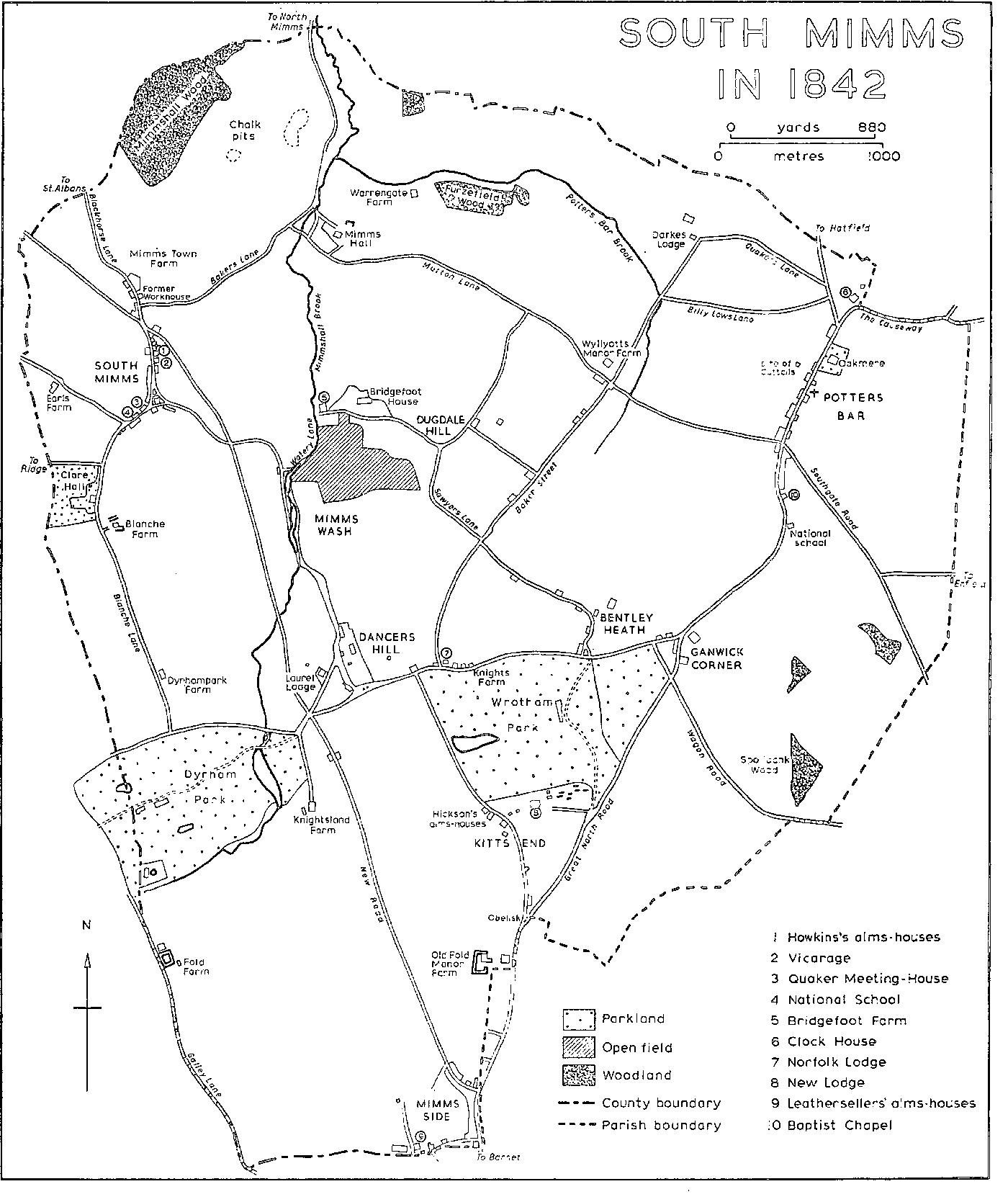
SOUTH MIMMS IN 1842
The broad pattern of settlement and communications remained virtually the same until the 19th century. The divisions within the parish are perpetuated in the modern districts of Potters Bar (including the village of South Mimms) and Barnet, part of which lies in Barnet L.B.
Early settlement seems to have avoided the wooded slopes of London Clay and to have sought the gravel-capped ridge, with its well-water, and also the shelter of the Mimmshall brook valley, where the soil could more easily be worked. Roman settlement along the high ground at Parkfield, Potters Bar, is indicated by finds of tiles, a small tile-kiln, and pottery of the 1st century A.D. (fn. 88) The early importance of the extreme north-west is shown by the building there of both a castle, on the site of what appears to have been a Saxon settlement, (fn. 89) and South Mimms manor-house. In the 13th century the manor-house, together with its mill, stood north of the main village, perhaps because increasing traffic, particularly after the establishment of Barnet market, made the route to St. Albans a more attractive position. Settlement centred upon the church and by c. 1220 there was a sprinkling of tenements along the roads leading towards it. (fn. 90)
Another village grew up in the north-east, at Potters Bar. Although the name is not recorded until 1381, (fn. 91) the first part is presumably derived from the 13th-century family of Le Pottere. The 'bar' is said to have been one of the gates of Enfield Chase, (fn. 92) although in 1594 it is shown well away from the boundary. (fn. 93) By c. 1200 the site of Cattalls had been established at the north end of High Street, along the gravel-capped ridge. The manor-house of Wyllyotts stood on the west side of Darkes Lane and to its south at Mutton Lane cross-roads was the manorial pound. Scattered tenements lay north of the house, several along tracks leading to the Chase. The moated site of Darkes, recorded in 1490, was linked to the manor-house by Darkes Lane and with other small tenements which lay along New Lane and the Causeway. Tenements belonging to the Moss family, such as Long Croft recorded by 1432, (fn. 94) stood north and south of New Lane, and houses at Tottenhalls and at the Clock House site were held by Simon Flexmore. Near the manor-house in the southern part of Potters Bar (fn. 95) lay several small tofts. Geffrons, recorded as early as 1278, (fn. 96) stood west of the Barnet road and south of a pathway which ran parallel to Mutton Lane and led from Goodwin Stile to Darkes Lane. (fn. 97) By 1455 Geffrons and a toft called Bovyngdons, also known as Pounses, (fn. 98) had passed to Sir John Fortescue; (fn. 99) they formed part of the manor of South Mimms in the 16th century. (fn. 100) Growth in the areas bordering on Enfield Chase and around the church is reflected in the election of aleconners for those two districts in 1345. (fn. 101)
By the 13th century Old Fold manor, with its well-defined moat, (fn. 102) was an important centre on the edge of Hadley Green. The manorial mill, standing on one of the highest points in the parish, was recorded in the 13th century and Old Fold park was early formed. (fn. 103) Blanche Farm in the west of the parish was recorded in 1420. To its south an earthwork and enclosure probably mark the early site of Dyrham Park manor-house. Farther west, adjoining Galley Lane and south of Fold Farm, is a small moated enclosure, with traces of brickwork. Another concentration of population in medieval times was in the middle of the parish at Dancers Hill, along the old road to St. Albans. By the 15th century many of the fields and property there were known as Mandeville or variants of Mandeville and belonged to the manor of South Mimms. (fn. 104) In 1489 several lanes led to small crofts and cottages in the area. (fn. 105)
In medieval times, however, there were large tracts of woodland or waste. Waste-land lay south of the village of South Mimms (fn. 106) and most of the area south of Dancers Hill Road was also originally common land, with two large gravel pits which later became fishponds. (fn. 107) The north-east part of the modern Wrotham Park was formerly Bentley Heath. Farther west lay the waste known in 1479 as Kitts End Heath, (fn. 108) and to the south was Kitts End Green. On part of the green was a cottage, with a moat (fn. 109) of which one side remains, known in the early 17th century as the hermitage and said to have been a chapel to which the dead had been taken after the battle of Barnet. (fn. 110) The battle had been fought on the borders of South Mimms and Monken Hadley in 1471 (fn. 111) and a chapel was afterwards built on the plain about half a mile from Barnet; in the late 16th century the chapel served as a dwelling. (fn. 112) By the mid 17th century the hermitage had come into the hands of John Howkins, (fn. 113) a local landowner and benefactor, who in 1651 planned to rebuild it. (fn. 114) In the 18th century it was incorporated in Francis Barroneau's estate of New Lodge. To the north-east lay an area called Dead Man's Bottom, perhaps also associated with the battle. A commemorative obelisk was erected on the line of the Gannick Bank in 1740 but in 1842 was moved to its present site south of Wrotham Park. (fn. 115)
In the 16th and 17th centuries several cottages were erected on the waste at Kitts End and encroachments were made on the Chase. (fn. 116) More notable was the construction of country residences by prosperous Londoners, some of whom are commemorated in the parish church. The Elizabethan manor-house of Durhams occupied the site of the later building and to its east in a hollow lay the farm-house of Knightsland. In the centre of the parish in Dancers Hill Road stood a house called Richards and to the north, on the site of the later Bentley Heath farm-lands, was the house known as Gannock, which existed by 1627. Farther north a house which later formed part of the Bridgefoot estate was recorded in 1567 and the 'capital messuage' at Cattalls Grove, Potters Bar, was built in 1596. Apart from Knightsland most of the the 16thcentury dwellings have been demolished. A residence called Knights, about half-way between the southern end of Baker Street and Bentley Heath on the north side of Green Dragon Lane, (fn. 117) belonged to John Adderley (d. 1652) (fn. 118) and afterwards to Col. William Webb, Surveyor-General of Woods. (fn. 119) When the lane (later Dancers Hill Road) was diverted in 1815, the house was pulled down and the gardens, which lay near the site of the Byng mausoleum, were incorporated in Wrotham Park. (fn. 120) Wicks Place at Dancers Hill was owned by John Nicholl of Hendon Hall in 1709, when it formed part of a settlement made on the marriage of his son John to Mary Pym; the property included several cottages and 29 a. of land. The house was bought in 1808 by Henry Heyman, who renamed it Laurel Cottage, and afterwards passed to the Trotters of Dyrham Park, who called it Laurel Lodge. It housed soldiers during the Second World War and was demolished in the late 1950s. (fn. 121) In c. 1670 a copyhold house called Ottways Garden, later known as Bridgefoot Farm, stood on part of the Bridgefoot estate. Seventeenth-century barns are recorded at Knightsland, Bridgefoot Farm, and Fold Farm. (fn. 122) A striking feature was the rebuilding or enlarging of several existing houses. Most of the fabric of Blanche Farm dated from c. 1600 and both the north part of Mimms Hall and the west part of Wyllyotts from the 16th century. The timber-framed house at Fold Farm was built in the 17th century on property which had belonged to the Cockett family in the later 16th century (fn. 123) and had passed to Thomas Ravenscroft, (fn. 124) a governor of Queen Elizabeth's grammar school and a benefactor of Chipping Barnet. (fn. 125)
In the 16th and 17th centuries the main area of settlement was still South Mimms village, which assumed a roughly triangular shape. (fn. 126) The church has been considerably enlarged in the 15th and 16th centuries, while buildings clustered to the north and south of it. (fn. 127) By the early 17th century several buildings had been erected on both sides of Blackhorse Lane. Sparrow Farm was built on its west side c. 1500 and later converted into three cottages. Its upper storey probably once projected on the east side of the middle block, whose upper floor appears to have been open to the roof; it was of three bays, with double-chamfered wall-posts supporting cambered tie-beams with curved braces. The end blocks probably formed the original cross-wings. (fn. 128) To the north-east lay a group which in the early 17th century seems to have comprised the rectory house, South Mimms poorhouse, Shenley poorhouse, and the later Black Horse inn. Fields stretched around, including the rectorial land known as Waldens. (fn. 129) North of the church and occupying a central position on the St. Albans road stood the White Hart inn and between the church and the small vicaragehouse were the five Howkins's alms-houses, erected in 1652 to the annoyance of some neighbouring inhabitants. (fn. 130) A few widely scattered houses south of the church also formed part of the village. (fn. 131) Two other inns existed briefly: the Prince's Arms, which later formed part of the Clare Hall estate, was recorded in 1683, (fn. 132) and the Red Bull, adjoining Chantry mead, in 1714. (fn. 133)
In contrast to the village of South Mimms, Potters Bar until the 18th century seems to have remained a hamlet of small crofts. Many of the dwellings were probably made of wood, and there are frequent references to 'moving a cottage'. (fn. 134) Two wooden houses survived in High Street until c. 1950 and others existed in the Causeway. In c. 1580, however, a brick house, with two storeys and attics, was erected in High Street; it was known as Goodwin Stile in the later 17th century, when it belonged to James Hickson of the Brewers' Company of London, and later as Ladbrooke Farm and stood until c. 1911. Two inns were also built along the Hatfield section of the Great North Road: the Swan with Two Necks, called the New Inn in 1658, and the Green Man, recorded in 1672. (fn. 135)
By 1658 a large hamlet was spreading along the old St. Albans road at Kitts End. Cottages lay scattered around the area later occupied by Home farm. The Bull's Head inn was first recorded in 1523 (fn. 136) and six alms-houses, built by James Hickson on the slope descending to Dancers Hill, stood there from 1687 to 1856. In the southern part of the parish, at Barnet, shops and cottages had been erected by 1553. (fn. 137) Several inns catered for the many travellers using the Great North Road: the Robin Hood, held of the manor of Barnet, was recorded in 1659, (fn. 138) although its location is uncertain, and the Blue Bell in 1668. (fn. 139) The Hart's Horns, next to the Bell and seemingly on the corn er of the later Union Street, was mentioned in 1553 (fn. 140) and stood west of the Great North Road; (fn. 141) it was converted into shops in 1929. (fn. 142)
Despite the growth of villages and hamlets much of the parish was still open in the late 17th and early 18th centuries. (fn. 143) Two highwaymen were buried in South Mimms churchyard (fn. 144) and the two major roads also brought vagrants and other unwanted fugitives (fn. 145) from plague-stricken London. In 1665 'above one hundred and more, which died of the plague in the same year' were buried at South Mimms. (fn. 146)
In 1754 (fn. 147) most inhabitants were still living along the Great North Road and the road to St. Albans, mainly in South Mimms village and at Kitts End. South Mimms village seems to have spread along Blackhorse Lane, although spaces remained between the houses. South of the church buildings lined the western edge of the road but few had been erected on the other side. Several brick cottages, some of which later became shops, had been built at the southern end of the village in Blanche Lane and Greyhound Lane. At Kitts End houses lay scattered along the road to St. Albans (Kitts End Road), whence they spread eastward towards the Chase. Most of them were small cottages. often divided into two or more tenements. In 1728 eight such cottages, together with 11 a. of land, were sold by William Pratt to Thomas Reynolds, the owner of Pinchbank, (fn. 148) and c. 1750 at least ten copyhold cottages at Kitts End were held by Admiral Byng. (fn. 149) The hamlet was said to have eight inns in 1756, (fn. 150) although two, the Windmill and the Two Brewers, were in Enfield Chase, adjoining Monken Hadley. (fn. 151) The largest inn was the White Lion which had beds for twelve men and stabling for forty-three horses. It stood near the Hermitage and probably close to the Two Sawyers and the Angel (formerly known as the Chequers). South of the old road through Kitts End stood the Crown, which in 1767 took the name of the Angel after the older inn had been pulled down. (fn. 152) Farther south was the weatherboarded Bull's Head, (fn. 153) which for a short time was called the Three Compasses, (fn. 154) and between Gannick Bank and the Great North Road stood the Maypole. (fn. 155) A group near the White Lion included two wash-houses to the inn (fn. 156) and beyond was a house which was probably that licensed in 1732 as the Bunch of Grapes. (fn. 157) North of the hamlet stood Pinchbank, at one time known as Strangeways.
Houses were dotted along both sides of Dancers Hill Road, which contained Stonard's house and copyhold land called Angels, (fn. 158) the rent-charge on which supported Howkins's alms-houses. At the junction of Wash Lane and Dancer Hill Road, known as Cuckold Corner, there were various tenements in the late 17th century. (fn. 159) By 1712 they included a cottage, a shop, and other buildings, (fn. 160) one of which was licensed as the White Lion in 1726. (fn. 161) Another small cottage and a smithy had been added by 1732. (fn. 162) East of Cuckold Corner and opposite the end of Kitts End Road stood an inn called Mandeville, recorded in 1623 and renamed the Green Dragon by 1635; (fn. 163) it was sold to George Byng in 1768 (fn. 164) and by 1842 had moved to a new site on Telford's road. (fn. 165) East of Wash and Water lanes were groups of buildings belonging to two farms. (fn. 166) In 1712 George Howes, the occupier of the copyhold farm which lay south of Aldwick, had pulled down part of a mansion in Water Lane. (fn. 167)
The growth of South Mimms village, Kitts End, and Dancers Hill in the 18th century reflects increasing traffic along the two major roads. While the rural character of South Mimms village was frequently noted, the roads possessed many inns, offering comfort rather than elegance. (fn. 168) At High Street, Barnet, 18th-century inns included the Roebuck, which was later replaced by the Rising Sun, and the Green Man, in 1753 the meeting-place for beating the bounds of the parish and later said to have been much frequented by Sir Robert Peel. Others were the King of Prussia (changed to King George in 1914) and the Green Dragon, which was converted into shops in 1928. (fn. 169) Scattered inns faced the St. Albans road as it passed through Kitts End and Dancers Hill. At Mimms Wash stood the Five Bells (fn. 170) and the Badger, which was part of the Bridgefoot estate. (fn. 171) The approach to South Mimms village was marked by another concentration of inns. They included the Black Horse and the Queen's Head in Blackhorse Lane and the Cross Keys, where the post office was housed in 1845 between the church and the White Hart. (fn. 172) The Greyhound, formerly the Dog and Badger, (fn. 173) stood until 1918, and the Live and Let Live was licensed until 1907, when it was replaced by a garage, and the Black Bull until 1909. Towards Ridge Hill stood the Red Lion, formerly the Sun, which lost its licence in 1931, and to its north the Plough, licensed until 1907. (fn. 174)
Improvements to the Great North Road between Ganwick Corner and Lemsfordmills (Herts.) (fn. 175) led to some growth at Potters Bar. A third inn, the Robin Hood and Little John, was built in High Street, and to its south on a new site stood the Swan with Two Necks which had been renamed the White Horse. (fn. 176) Several inns were also erected along the road from Ganwick Corner to the Causeway. The Duke of York at Ganwick Corner was licensed in 1752 and known for a short time as the White Horse. (fn. 177) Adjacent to the Southgate road, the Lion was formed in 1761 out of two cottages. (fn. 178) The Red Lion, in the grounds of Morven and mentioned in 1686, (fn. 179) served a group of timber cottages which stood at the northern end of High Street; access was impeded after the construction of Hatfield Road in 1802 and the site was leased to the owner of Morven in 1856. (fn. 180) North of Mutton Lane timber houses lined both sides of the Hatfield-London Road (fn. 181) and by the late 18th century both Methodists and Baptists had begun to meet in barns near by.
In the 18th century the parish was still notable for the number of seats occupied by Londoners. The improved turnpike road brought Potters Bar within easy reach of the City and new houses included Wrotham Park, Bridgefoot House, Dancers Hill House, Easy Lodge (later known as Parkfield), Salisbury House, and Blake Hall, as well as the rebuilt Dyrham Park. Whereas several houses still exist and the sites of others are known, no trace remains of Blake Hall; it is sometimes shown on the site of the later Elm Court in Mutton Lane but in 1754 it was marked farther west on the south side of the road. (fn. 182) Near South Mimms village the estate of Clare Hall was also formed in the early 18th century. The most imposing seat at Kitts End was New Lodge, which was built in 1767 by Thomas Nuthall, ranger of Enfield Chase and later Treasury Solicitor; it had spacious grounds, with a paddock of 13 a. formed out of common land south of the house. (fn. 183) The Thackeray family lived at Kitts End in the later 18th century, before moving to Monken Hadley manor-house. (fn. 184) William Makepeace Thackeray, an officer in the Bengal civil service, was residing there in 1780 and in the following year his son Richmond Thackeray, father of the novelist, was baptized at South Mimms church. (fn. 185)
Several farm-houses were built or altered during the 18th century. Bridgefoot farm-house was built c. 1750, weatherboarded barns were erected at Earls and Bentley Heath farms, additions were made to Fold Farm, and the whole of Knightsland was cased in brick. (fn. 186)
With the establishment of mansions in spacious parks humbler housing tended to be confined to the main roads. In 1770 there were said to have been thirty encroachments into Enfield Chase at Potters Bar, (fn. 187) but most new buildings there and at Mimms Green were timber-built cottages and barns on small plots. (fn. 188) Cottages, barns, several shops, including a wheelwright's, and what later became a school-house were built on Mimms Green. (fn. 189) In 1769 encroachments included a cottage and an inn called the Maypole on the edge of the Chase, between Gannick Bank and the new line of the Great North Road. (fn. 190) The property then belonged to Thomas Nuthall and eventually passed to George Byng in 1782. (fn. 191)
In 1781 the common lands at Bentley Heath and Kitts End were added to the South Mimms allotment of the Chase and the whole was inclosed. (fn. 192) There was no radical change in the pattern of settlement, for by 1864 the neighbourhood was still very sparsely populated, (fn. 193) but the landscape was greatly affected by allotments to the large estates, notably Wrotham, New Lodge, and Old Fold manor. (fn. 194) Kitts End Green was divided into seven portions, all of which, except that belonging to Turpin Bastick, were incorporated in the grounds of New Lodge. Francis Barroneau, the owner, also bought the Hermitage and other cottages from Lord Salisbury and in 1786 closed the road through the hamlet of Kitts End, since it ran between the paddock and the south front of his house. (fn. 195) New Lodge, standing in finely wooded grounds, was apparently a stuccoed building with side wings. (fn. 196) Joseph Farington, the Academician and diarist, stayed there in 1806 and was informed by Barroneau that a genteel establishment at that time could not be formed for much less than £10,000. (fn. 197) Adjacent to the hamlet of Potters Bar lay 108 a. from the Chase which formed part of the estate of Oakmere. (fn. 198) A house was built on land farther west and the grounds were landscaped.
The main change in the early 19th century was the reconstruction of the road from London to St. Albans, which diverted traffic from Kitts End, Dancers Hill, and the main street of South Mimms village itself. As a result 'the innkeepers and other frontagers relegated . . . to a stagnant backwater' (fn. 199) became impoverished, although the White Hart in South Mimms village had merely to acquire a new front in order to face the Telford road. The Cross Keys in South Mimms village (fn. 200) and the Angel and the Bull's Head at Kitts End were among the inns that disappeared. (fn. 201) The White Lion and near-by smithy at Dancers Hill reverted to private use, the smithy being pulled down in 1875. (fn. 202) The hamlet of Kitts End quickly decayed. Most of the properties and lands on the west side of the old Kitts End Road were bought by the Byngs of Wrotham Park, who replaced them with estate cottages. The Hickson alms-houses were moved from Kitts End to South Mimms village in 1856. A few years later New Lodge was demolished and its grounds were added to Wrotham Park. By the 1860s the old hamlet of Kitts End had been absorbed into the park, which then occupied a large triangle of land. (fn. 203)
Apart from the National school erected in 1834 very little building took place in South Mimms village, whose population declined between 1851 and 1861. There were 174 houses in 1871 but by 1901 the number had increased only to 200. (fn. 204) Many cottages fell into disrepair and were described in 1895 as insalubrious. (fn. 205) By the late 19th century an annual fair enjoyed only a lingering existence and the village was considered to be suitable for an isolation hospital.
Steady growth at Potters Bar in the early 19th century is evidenced by the building of a church, chapels, and a school. By 1851 the district of St. John's contained 187 houses and had a population of 992. The construction of the G.N.R. did not, however, lead to rapid change; the population dropped to 959 in 1861 and rose only to 1,691 in 1901, a much slower rate of growth than in the southern part of the parish. (fn. 206) Meanwhile several inns opened near the workmen's temporary camps in Dove Lane and Mutton Lane. The Railroad inn (or the Beer Engine House) in Mutton Lane lost its licence in 1906 and afterwards became known as Limerick House, the local headquarters of the British Red Cross Society. The Old Station hotel, opened in Darkes Lane c. 1880, was rebuilt c. 1938 and renamed the Potters Bar. (fn. 207) Two London speculators, George Singer and Robert Vickery, in 1855 became copyhold tenants of c. 30 a. of the manor of Wyllyotts and the next day purchased the enfranchisement, planning to develop the Osborne Park estate in the north of Potters Bar by laying out over 200 plots. Little, however, was actually built, apart from the Builder's Arms in Heath Road, some cottages and shops in Church Road, and a few houses in Osborne and Heath roads, one of which presumably later became Lochinver school. Other 19th-century building was mainly confined to large houses, notably Morven, Mount Grace in Church Road, and a few in Wagon Road and Baker Street, and to cottages on the south side of the Southgate road. (fn. 208) Morven was erected on the site of the 16thcentury Clock House, replacing a house built there by the Hammonds in c. 1750. Its occupier in 1856, Mrs. Catherine Lee, obtained a 99-year lease of part of the site from the Brewers' Company of London.
The fastest growth, however, was around Barnet, which was still an important thoroughfare and, especially after 1872, linked by good rail services to London. Union Street, adjacent to High Street, was laid out c. 1835 (fn. 209) and the boundary stone marking the division between the parishes of South Mimms and Chipping Barnet was placed 198 yards from the eastern end of it. (fn. 210) In 1838 six alms-houses were built by Richard Thornton, former master of the Leathersellers' Company of London, on land in Union street which had been acquired by the company in 1603. (fn. 211) Six more alms-houses were founded in 1850 and a lodge was erected c. 1860, when accommodation was limited to the aged poor of the company. A single-storeyed northern block was built in 1866 for seven inmates from John Hasilwood's alms-houses at St. Helen's, Bishopsgate (London), and a chapel was added in 1931. In 1966 the two-storeyed east and west blocks were rebuilt and in 1972 the Leathersellers' alms-houses, of light stone and in the Gothic style, formed three sides of a quadrangle around a garden.
By the 1850s there were many inns, shops, and schools near by in Union Street, especially along its northern side, and in High Street. (fn. 212) A Roman Catholic church was built in High Street in 1850 and replaced by one in Union Street in 1865, to which several schools were attached. (fn. 213) Christ Church and its schoolrooms were built in New Road in 1844-5 and within a decade buildings had spread along both sides of the road as far as the church: they included commercial premises, 'an academy', and the 18th-century White Lion. (fn. 214) By 1871 Christ Church parish contained 342 houses in which lived 1,598 persons, nearly 50 per cent of the total population of South Mimms. Twenty years later there were 699 houses in the Barnet portion of the old parish, compared with 180 in South Mimms village and 328 in Potters Bar. (fn. 215) In 1864 Alston and Stapylton roads and the Avenue had been laid out but contained only a few buildings. (fn. 216) Expansion (fn. 217) within the next thirty years consisted mainly of filling the gaps between Alston and Stapylton roads. Strafford, Carnarvon, and Salisbury roads, and the Drive had all been built by 1897, with Marriott and Ravenscroft Park roads to the west. More buildings were erected along Union Street, those on the south side standing especially close together. In addition to residential housing the Albion was opened in Union Street (fn. 218) and the Sebright Arms in Alston Road. Schools lined Salisbury and Strafford roads, mission rooms appeared in Alston Road and shops in Calvert Road, (fn. 219) until 1901 there were 942 houses in the area. (fn. 220) Afterwards the rate of growth slowed down, although building continued north of Alston Road, where a dental manufacturing works had been established. (fn. 221) By 1906 premises at nos. 95 and 97 High Street were occupied by Barclays Bank and more shops and coffee rooms had been opened. (fn. 222) In the later 19th and early 20th century several military battalions had barracks in Union Street, Stapylton Road, and Salisbury Road. (fn. 223)
In Potters Bar many large houses were built between 1850 and the First World War. (fn. 224) Banister Fletcher designed some detached houses in the Avenue, (fn. 225) 'of an economic character', (fn. 226) with cementcovered walls, steeply-pitched roofs, and tile-hung gables. (fn. 227) Plans to extend St. John's church had to be abandoned, largely because of opposition from the owners of family vaults. (fn. 228) Settlement, however, still tended to be concentrated along High Street, with very few buildings on the former Chase, apart from those belonging to Chase Farm. (fn. 229) By the early 20th century there was only a sprinkling of houses at the northern end of Darkes Lane, where a wooden hut was apparently the first shop in the 1930s. (fn. 230) In 1902 36 a. belonging to Wyllyotts manor at Dugdale Hill was sold to Lord Salisbury and in 1919 South Mimms R.D.C. bought 3 a. in Mutton Lane for a depot, although they failed to purchase Wyllyotts manor-house from the Brewers' Company of London. (fn. 231)
There was a lack of humbler housing despite some building in 1901 in Blanche Lane. (fn. 232) Three years later in both South Mimms village and Potters Bar the poor suffered from much overcrowding and high rents. (fn. 233) Six cottages were erected at Mimms End by E. L. Hamilton in 1914 and the R.D.C. built twelve more in 1915 on land adjoining the St. Albans road, part of which was occupied by a sewage disposal works. The twelve cottages, together with another ten built there in 1921, to be known as the Cecil Cottages. (fn. 234) In the 1920s, however, there was still much insanitary housing in South Mimms village and the vicar offered to sell a small piece of glebeland on the condition that only workers' homes should be built there. (fn. 235) In 1929 the council built 120 houses in Mutton Lane but in 1930 the chairman stated that four cottages which had been condemned forty years before were still occupied. By 1939 344 council houses had been built, mostly along Mutton Lane and on the Cranborne estate in the north-west part of Potters Bar. Private houses, mainly detached, were still under construction north-west of Potters Bar station in the Avenue, Heath Drive, and Mount Grace Road. (fn. 236)
New housing in the 1930s (fn. 237) consisted mainly of bungalows in the area between High Street and Darkes Lane, and around Baker Street. Residential roads, many of them closes, appeared on both sides of Baker Street, while between the Walk and Byng Drive blocks of flats were erected in Strafford Gate. Some building took place in the grounds of former mansions: in 1938 a school was built on land once belonging to Parkfield, and in 1937 and 1949 houses were erected on part of the Oakmere estate. The spread of housing in the western part of Potters Bar led to the building there of Cranborne school in 1933 and the establishment of a mission, from which developed the parish of King Charles the Martyr.
The first multiple stores appeared in High Street c. 1930 but the main shopping parade developed in the southern half of Darkes Lane. As early as 1895 a room had been rented by Messrs. Sharples, Lucas Tuke and Co., later amalgamated with Barclays Bank, who provided a one-hour banking service two days a week. A post office, first established at the Green Man, transferred to the premises later used by Barclays and afterwards moved to the Barnet road. In 1935 a sorting office was built in Darkes Lane and in 1963 a Crown post office was opened next to it. A telephone exchange was opened in 1903 at a private house in Hatfield Road but moved in 1930 to a large building at the corner of Billy Lows Lane, where new premises were built in 1972.
While housing spread west of High Street towards South Mimms village, it was not until the 1950s that there was much growth east of the road. Outside authorities eventually bought 80 a. there for council housing: in 1952 Edmonton B.C. compulsorily purchased land adjoining Mutton Lane and Barnet Road, while Tottenham B.C. acted similarly over land behind the Causeway and Tempest Avenue. The Torrington estate, a large private estate between Tottenham's property and the Causeway, was completed in the 1960s. Near-by estates, Trewenna and Bear Wood, were still under construction in 1973. There was also considerable building in the southern end of Potters Bar, which included old peoples' houses in Byers Close. High density building after 1950 gave rise to many maisonettes, including those in Rosary Court and on the Mutton Lane estate. Five-storeyed offices were erected in 1963 in High Street and a year later an eight-storeyed office block was built in Darkes Lane, opposite the station. A similar block was erected in Mutton Lane on land sold by the Congregational church.
Despite the spate of building the network of houses and roads in Potters Bar is broken up by large open spaces. On either side of High Street lie the parklands of Oakmere and Parkfield, with King George's field to the west and, beyond that, Potters Bar golf course. The area is fringed by woodland and residential roads are tree-lined. In 1973 there were striking contrasts between the suburban avenues covering the north-east of the parish in Potters Bar, the old village in the north-west, and 19th-century housing in Barnet. Much of the parish was still open, with farm-land mainly in the centre and some patches of woodland.
Although bounded by motorways, the village of South Mimms has retained a rural air. It is dominated by the church, with its bold tower and 'perfect village cemetery' (fn. 238) which stands west of Telford's road and south of Hickson's alms-houses. (fn. 239) To the south are the modern vicarage house (called 'the Rectory'), with its old garden wall and gateposts, and the glebeland. Blackhorse Lane, north of the church, contains three red-brick 18th-century cottages. North-east of council housing in the same road stands the Black Horse inn, red-brick and with an early-18th-century exterior. To its south, at the junction of the old and new St. Albans roads, is the timber-framed White Hart, late-17th-century but much altered and containing some 18th-century plaster panelling on the first floor and a plaster ceiling. The upper village has several 18th-century houses along Greyhound and Blanche lanes, among 19th-century grey-brick cottages and neo-Georgian 20th-century houses. South of the Rectory in Blanche Lane stand the 'Village Stores', an 18th-century redbrick cottage, and the Post Office Stores, early-18thcentury and of whitewashed brick, with some timberframing at the rear. At the corner of Blanche and Greyhound lanes stands the White House, a Regency building. In Greyhound Lane is Cedar House, red-brick and of the 18th century, with modern additions on the west; it has bow windows on either side of the door and two venetian windows on the first floor.
West of South Mimms village stands Earls Farm with its modern house and 18th-century weatherboarded barns. Blanche Lane leads southward past Clare Hall hospital, mainly huts to the north of a red-brick house almost opposite Blanche Farm. Its grounds contain a lake and examples of 19th-century landscape gardening. A new farm-house has been erected at Blanche Farm on the site of an earlier building. In contrast to the western fringes of the village, the eastern parts illustrate 20th-century growth. Beyond a garden centre at Bignell's Corner at the end of Greyhound Lane stand the modern Middlesex Arms and the Esso Motor hotel.
Fields stretch across the centre of the parish, interspersed by farm-buildings and several large houses. South-east of South Mimms village stands the mid-18th-century red-brick farm-house at Bridgefoot next to three 17th-century barns, one of five and the other two of three bays, weatherboarded and with pantiled roofs. North-east of the farm the modern Bridgefoot House has replaced the 18thcentury residence. Farther south-east in Bentley Heath Lane and near Elm Farm is the 17th-century house belonging to Bentley Heath Farm, of brown brick and with a stuccoed doorcase. There are two 18th-century barns, of seven and four bays respectively. West of the corner of Bentley Heath Lane and Dancers Hill Road, at which stands Trinity chapel, are several 18th-and 19th-century buildings, including Norfolk Lodge, and some cottages erected by 1875 by the Trotters of Dyrham Park on the site of the former smithy and cottage. (fn. 240) At the north end of Dancers Hill, along Wash Lane, is the stuccoed Dancers Hill House, long and narrow. To its north is the L-shaped house of Dancers Hill Farm, a stuccoed building with a green slate roof; the north çade has a flat rusticated doorcase and the west çade has a ground floor semicircular bay, above which are three-light semicircular windows. Two inns in the centre of the parish possess 18th-century buildings. West of the St. Albans road and south of Wash Farm is the whitewashed brick building of the Green Dragon, which previously had stood opposite Kitts End Road since at least the early 17th century. At Ganwick Corner, south of Potters Bar, stands the Duke of York, 18th-century and red-brick, with many later additions.
The area south of Dancers Hill Road is dominated by two large estates: Dyrham Park and Wrotham Park. Dyrham Park, in 1973 used by a private golf club, is surrounded by lodges and arched gateways. The long mansion stands in wooded grounds, which contain several lakes. To the east the ground rises steeply to the finely timbered park of Wrotham, overlooked by its imposing house and incorporating several lakes and the scattered remains of stone buildings. North and east of the park in Bentley Heath Lane, Dancers Hill Road, and the Great North Road, lie several groups of estate cottages, bearing the letter 'S' and erected by George Byng, earl of Strafford (d. 1886).
Scattered among the fields at the southern end of the parish are several old farm-buildings. Near the entrance to Dyrham Park is the 16th-century Knightsland Farm and on the east side of St. Albans Road is a 17th-century barn of half H-shaped plan. South-west of Knightsland, on the boundary in Galley Lane, is Fold Farm, with moat. The Lshaped farm-house, timber-framed and faced with brick, was built in the 17th century but later extended; 17th-century barns to its north and east have been much altered. East of Wrotham stretch fields, diversified by patches of woodland.
Just beyond the southern tip of Wrotham Park lies the area known as Hadley Highstone, whose northern part lies within South Mimms. Old Fold Lane and Taylors Lane, west of the Great North Road, are lined by cottages and terraces, some of them stuccoed and mostly 19th-century. To the north stands the former childrens' hospital and, farther north, Kitts End Lodge, a red-brick building in the Gothic style. West of Hadley Green the Byng Road playing fields and Old Fold Manor golf course are patches of green fringing the suburbia of High Barnet. West of Barnet High Street houses, mainly 19th-century, line a network of roads, whose character is varied by the grounds and Tudor-style buildings of Queen Elizabeth's grammar school and the Leathersellers' alms-houses. There are few old buildings in the neighbourhood, apart from some small 18th-century cottages and houses in St. Albans Road, among them the White Lion.
Barnet High Street is lined with 20th-century shop fronts, which in many cases conceal earlier structures.
Among the 20th-century housing, industrial estates, and shopping centres in Potters Bar, are some old survivals, most of them along the Great North Road (High Street). The Green Man, at the northern end of High Street, is timbered and plastered and apparently 17th-century, although 'much altered' by 1937. To its south stands the White Horse, a long low building of the early 18th century, plastered, with a Victorian verandah and bay windows. At the junction of High Street with the Southgate road is the Lion, a late-18th-century stuccoed building with later additions. Salisbury House, which became a private school in the 19th century, stands on the east side of High Street. A two-storeyed, red-brick house of the 18th century, it has a wooden doorcase and parapet wall, and an extension. Farther north-east is the Victorian mansion Oakmere House, with its wooded grounds, which include 3 a. of ornamental water. (fn. 241) Between High Street and the Causeway stands another Victorian house, Morven Park; it was acquired by the National Trust c. 1930 and almost half of its grounds lie outside the parish. The corner of the Causeway and Hatfield Road is dominated by the white and gold war memorial, designed in 1920 by C. F. A. Voysey. (fn. 242) To the south-west, in Darkes Lane, the timber-framed structure of Wyllyotts manor-house stands next to modern council offices and adjacent to the railway station, industrial estate, and main shopping parade.
The extreme north-west of the parish, where early settlement had focused, consists mainly of farm-land, through which several major roads pass. The few scattered buildings, all east of the road, include Warrengate Farm and the small 16th-century L-shaped manor-house at Mimms Hall. To the west, fields stretch out towards Mimmshall wood, crossed by public footpaths.
There were 340 communicants in 1547 (fn. 243) and 292 adult males who took the protestation oath in 1641. (fn. 244) In 1676 480 conformists and 20 nonconformists were recorded. (fn. 245) The population seems to have fluctuated in the 17th century, with outbreaks of plague in 1603, 1623-5, and 1665. Numbers increased during the 18th century, although smallpox contributed to a rise in infant mortality, (fn. 246) and rose steadily from 1,698 in 1801 to 3,238 in 1861. From 1871 to 1901 the population more than doubled, largely because of building around Barnet. The rise levelled off after 1911, only to increase again in 1931, when South Mimms R.D. contained 5,720 persons, at a density of 0.93 persons an acre, and South Mimms U.D. had 5,501 persons at a density of 20.2 persons an acre. Between 1931 and 1951 the population increased by 100 per cent; the number of persons in South Mimms U.D. (i.e. High Barnet) was 4,481, compared with 17,172 persons in Potters Bar U.D. In 1961 Potters Bar U.D. contained 23,376 persons. (fn. 247)