A History of the County of Middlesex: Volume 5, Hendon, Kingsbury, Great Stanmore, Little Stanmore, Edmonton Enfield, Monken Hadley, South Mimms, Tottenham. Originally published by Victoria County History, London, 1976.
This free content was digitised by double rekeying. All rights reserved.
A P Baggs, Diane K Bolton, Eileen P Scarff, G C Tyack, 'Tottenham: Growth after 1850', in A History of the County of Middlesex: Volume 5, Hendon, Kingsbury, Great Stanmore, Little Stanmore, Edmonton Enfield, Monken Hadley, South Mimms, Tottenham, ed. T F T Baker, R B Pugh (London, 1976), British History Online https://www.british-history.ac.uk/vch/middx/vol5/pp317-324 [accessed 2 May 2025].
A P Baggs, Diane K Bolton, Eileen P Scarff, G C Tyack, 'Tottenham: Growth after 1850', in A History of the County of Middlesex: Volume 5, Hendon, Kingsbury, Great Stanmore, Little Stanmore, Edmonton Enfield, Monken Hadley, South Mimms, Tottenham. Edited by T F T Baker, R B Pugh (London, 1976), British History Online, accessed May 2, 2025, https://www.british-history.ac.uk/vch/middx/vol5/pp317-324.
A P Baggs, Diane K Bolton, Eileen P Scarff, G C Tyack. "Tottenham: Growth after 1850". A History of the County of Middlesex: Volume 5, Hendon, Kingsbury, Great Stanmore, Little Stanmore, Edmonton Enfield, Monken Hadley, South Mimms, Tottenham. Ed. T F T Baker, R B Pugh (London, 1976), British History Online. Web. 2 May 2025. https://www.british-history.ac.uk/vch/middx/vol5/pp317-324.
Growth after 1850.
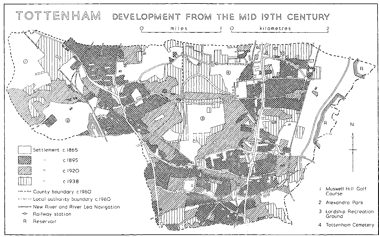
The arrival of the Northern and Eastern railway in 1840 did not markedly improve communications with London, nor did new centres of population arise around the first stations, east of Tottenham Hale and near Asplins Farm. (fn. 1) The situation of the stations, however, was responsible for buildings spreading eastward from High Road. By 1863 Tottenham Hale had been joined to the village around the high cross by buildings along the south side of High Cross Lane, while terraces lined part of the new Somerset and Chesnut roads a little to the north; Stamford and Markfield roads had been laid out east of Page Green, where 84 small building plots had been offered for sale ten years earlier, (fn. 2) although a stretch of Broad Lane still approached Tottenham Hale through fields. Farther north near Park station there were houses along part of Marsh and Willoughby lanes, where St. Paul's church had been built and Willoughby House had been demolished in 1858, (fn. 3) and many middle-class villas along a new link between the railway and High Road, called Northumberland Park. Tottenham, on a map, no longer appeared as a ribbon of settlement.
Several plans for further railways were canvassed in the 1840s and 1850s. (fn. 4) The prospect of better communications and public services, rather than the state of those already enjoyed, probably stimulated development in the 1850s, when the population rose by more than 4,000. (fn. 5) A new cemetery, amid fields north of the parish church, was consecrated in 1857, one year before the Drapers' Company of London bought the Elms opposite the high cross as the site for a boys' school and alms-houses. Tottenham's change from a select residential neighbourhood into a crowded, lower-middle- and workingclass suburb was hastened from 1858, when the City merchants and gentry who hitherto had dominated the local board were replaced by men who worked locally, notably doctors and builders, and who saw the district as ready for development. (fn. 6) Hasty building, allowing the population to rise by nearly 10,000 in the 1860s, (fn. 7) brought many crises over water supply and sewerage, for which Tottenham became notorious.
By the mid 1860s there was no open country along either side of High Road north of Tottenham Green, although many residences still stood in their own grounds. Between Seven Sisters and Hanger Lane (later St. Ann's Road) the only buildings were Stonebridge House on the west, Markfield House on the east, and a bridge carrying the Tottenham and Hampstead Junction railway. Housing was densest in the north, along lanes and alleys close to High Road south of White Hart Lane, with small terraced dwellings in William, Moselle, and Whitehall streets, formerly occupied by White Hall, as well as in Love Lane and Church Road. Development along the roads leading to the G.E.R. stations was partly balanced by housing along the chief roads to the west: Hanger Lane, West Green Road, Philip Lane, Lordship Lane, containing Bruce Terrace, and White Hart Lane. Only along the south side of Philip Lane, however, did it reach as far as another village, West Green.
In the eastern part of the parish most of the premises along High Road still backed on open country north of Tottenham Hale and south of Marsh Lane. Beyond the railway line the marshes contained little apart from Ferry Lane, leading past Tottenham lock to the recently gutted mills, and from Stonebridge lock, Asplins Farm, and a new rifle range in the extreme north-east. The centre of the parish was also rural, from Downhills park northward to Clay Hill. Beyond a group of houses around Bruce Castle, Lordship Lane ran through fields which stretched to Chapmans Green, the sole buildings being those of Broadwater and Grainger's farms. West of Tottenham Park, White Hart Lane similarly passed nothing except Tent Farm and a few cottages, while the lane to the north led past Clayhill (later Devonshire Hill) Lodge and River House, across the New River to Clayhill Farm on the boundary.
TOTTENHAM DEVELOPMENT FROM THE MID 19TH CENTURY
South of Downhills changes proceeded more rapidly. Farm-land still stretched westward from High Road to Green Lanes, along the course of Stonebridge stream, and, in places, bordered West Green Road and Hanger Lane, but there were clear signs that the entire length of West Green Road would soon be lined with houses. West Green itself retained some large dwellings, including West Green House, West Green Lodge, Woodlands, and Gothic House, and possessed a school and chapel. It was linked with High Cross not only along Philip Lane but by terraced housing in the new Clyde Road, where 36 a. of meadow had been offered for building in 1851; (fn. 8) Philip Lane and West Green Road were connected by Summerhill Road, where terraces had been built in 1856 and 1859, and by Bathurst (later Lawrence) Road, which contained a floor-cloth factory. To the west Stanley Street (later Road) and some neighbouring roads had been laid out, between the old village centre and the junction of West Green Road with Green Lanes. A few houses had been built south of the junction and others stretched northward, facing Ducketts Common, as far as Ducketts farm-house, then called Dovecote House.
Less than a half a mile south of West Green, a new centre was arising around St. Ann's church, consecrated in 1861. The church, together with its vicarage house, model cottages dated 1858, and schools, had been paid for chiefly by Fowler Newsam, who lived in High Road at Stamford Hill. It served the Chestnuts and St. John's, Suffolk, Oak, and York lodges, near by, and other large residences in the south part of the parish: the Retreat and the Hermitage, amid fields bordering Hermitage Road, Woodberry Lodge, Albion Lodge, Gothic House, and Barnfield House, farther east in Hanger Lane, and several mansions at Stamford Hill, where Coleraine House, the Shrubbery, and Sherborough House all stood on the Tottenham side of the boundary. Newsam's choice of a rural site had been attacked by those who felt that a church was more urgently needed at West Green or Tottenham Hale. (fn. 9) By the mid 1860s, however, the new parish was already losing its exclusive air; the Avenue and South Grove had been laid out near the church, the Tottenham and Hampstead Junction railway cut across both Hermitage Road and Hanger Lane, and the tile-works still existed in the extreme south-west.
Even more rapid growth took place at Wood Green, where the church built in 1844 was found to be far too small by 1863. A direct railway to London, foreshadowed by the G.N.R. line in 1850 and achieved with the opening of a station ten years later, combined with undulating, still partly wooded, country to make the area attractive to large institutions, as well as to speculators planning a new middle-class suburb. Wood Green was 'as charming a spot as its sylvan name implies' in 1847, when the foundation stone of the Fishmongers' and Poulterers' institution was laid immediately north of the church. (fn. 10) The institution, an asylum for 12 married couples, was opened in 1850. It was designed by Mee and William Webb as an imposing two-storeyed (fn. 11) range in the Tudor style, with a central turreted gateway. South of the church the Printers' alms-houses, another two-storeyed Tudor range designed by Webb, were founded in 1849 for 12 couples and opened in 1856. In 1871 two more wings doubled the accommodation, and twenty years later an extension was opened by the duchess of Albany, marking the first royal visit to Wood Green. (fn. 12) The Royal Masonic institution opened its boys' school in Lordship House, Lordship Lane, in 1857 and replaced it with a large new building, later the Home and Colonial training college, in 1865. In that year land in Nightingale Road was provided for John Fuller's alms-houses, after the original site in Shoreditch had been sold. (fn. 13) Wood Green's first elementary school was opened in 1859 and its first chapel was built, by Congregationalists, in 1864.
Wood Green began to grow neither around the old common nor the new station, but north of the church in the triangle between Green Lanes and Bounds Green Lane. Commerce, Nightingale, Finsbury, Truro, and Clarence roads were all laid out there in the mid 1860s. South-east of Wood Green common, Caxton and Mayes roads were also laid out and near the Hornsey boundary a tobacco factory and reservoir bordered the railway. Cherson House, Wood Green House, and other large residences still overlooked the New River near the common. To the east, along Lordship Lane, Elm Lodge stood with a few cottages at the former Chapmans Green. To the north-east Green Lanes ran past the entrance lodge of Chitts Hill House, which stood with a farm-house in some 31 a. in 1843, when it belonged to Mary Overend; (fn. 14) Mrs. Overend still lived there in 1862 (fn. 15) and Samuel Page in 1867. (fn. 16) In contrast with the rows of villas leading off the north side of Bounds Green Lane, building on the south side was confined to a group opposite the church and to Nightingale Hall opposite Commerce Road. Nightingale Hall, with grounds and farm-land totalling 72 a., was occupied by Thomas Pearson in 1843; (fn. 17) it passed in 1864 from Pearson to his widow, (fn. 18) afterwards Mrs. Pearson Kidd, who lived there for another 30 years. (fn. 19) Farther west the only buildings were at Bounds Green, which possessed some cottages, a tavern, and a brick-works, and at Tottenham Wood Farm, which was approached by a lane from Muswell Hill in Hornsey. The first Alexandra Palace was not built until 1873, although a pleasure ground along the Hornsey boundary was opened ten years earlier.
Building in the 1860s mostly took place in the hitherto neglected parts west of Tottenham High Road, particularly around West Green and at Wood Green. While the total population rose by nearly 10,000, Wood Green ward alone saw an increase of some 5,500. (fn. 20) By 1869 residents at Wood Green were demanding their own local board (fn. 21) and it was clear that their new suburb, enjoying a separate rail link with London, had a future of its own. (fn. 22) Inevitably development thereafter spread around High Road in the east of the parish, the railway lines in the south, and Wood Green in the west, leaving farm-land in the centre and north which was not touched until the 20th century.
The crucial factor in the sudden growth of the eastern part of Tottenham was the arrival of the G.E.R., ultimately running from Liverpool Street to Enfield, in 1872. The line itself destroyed most of the rural advantages still enjoyed by large houses on or near the west side of High Road, including those in Bruce Grove. More important, the issue of cheap early morning tickets to London, which was strenuously opposed in local newspapers, attracted thousands of working-class immigrants and finally ended Tottenham's reputation for health and gentility. (fn. 23) By 1876 housing stretched almost continuously along the two miles from Stamford Hill to Edmonton; much of it was considered commonplace and some of it wretched, although here and there wrought-iron gates or walls with overhanging trees recalled more stately days. (fn. 24)
The opening of stations on the Tottenham and Hampstead Junction line, beginning with South Tottenham in 1871, and the construction of the G.E.R. line through West Green in 1878, hastened the spread of building over the south of the parish. By 1875 villas around St. Ann's had been built on ground recently deemed an irreclaimable morass and West Green had been transformed: 'the old village is still there, but it is huddled up against Streets, and Villas, and Places, and all the other devices of modern investors.' (fn. 25) In consequence the population of the parish more than doubled during the 1870s, when the urgent demand for elementary education frustrated determined local efforts to avoid a school board, and had reached 97,174 by 1891. (fn. 26) The effects of the influx were recognized in 1888, when Tottenham, with West Green, was separated from Wood Green. Their differing characters were described in 1894: Tottenham, the most populous of all London's outlying districts, was mainly given over to the lower middle class, notably City clerks and warehousemen, whereas Wood Green had many well-to-do residents. (fn. 27) For much of the area, including the southern part of Wood Green, the assessment was flattering; standardized stock-brick terraces formed a working-class railway suburb, where houses stood 40 to an acre, 'with back gardens distinctly minimal and front gardens merely nominal'. (fn. 28)
Much building covered the sites of former mansions. Lordship Hall, on the south corner of High Road and Lordship Lane, was demolished for roadwidening in 1867. William Salte's house, auctioned after his death in 1817 and empty in 1870, made way for the shopping parade known as Criterion Buildings, dated 1880, and for Ruskin, Cedar, and Pembury roads. Soon afterwards Bruce Castle and Birkbeck roads were built up (fn. 29) on land which had been auctioned with Fair Lawn, on the north corner of Lordship Lane, in 1875. (fn. 30) Farther south in High Road the parade called Grove Terrace, opposite Page Green, was also built in 1880 (fn. 31) and Suffield Lodge, at the south corner of West Green Road, was offered as building land in the same year. The Rows' residence at Page Green was also sold for housing with 11½ a. in 1880, as were Markfield House with 80 a. in 1879 and 90 plots on the near-by Earlsmead estate in 1882. (fn. 32) Properties auctioned at West Green included West Green House in 1884 and the Woodlands in 1888. The British Land Co. bought Downhills in 1881 and the neighbouring Mount Pleasant estate was offered as 135 building lots along Mount Pleasant Road in 1890. (fn. 33)
Sometimes a large private house was adapted to serve an institution, as when Avenue House on Tottenham Green was acquired by the Evangelical Protestant Deaconesses' institution (later the Prince of Wales's general hospital) in 1868, when Elmslea was bought by the Drapers' Company of London for Thomas Corney's school in the same year, or when Suffolk Lodge became a priory for the Servite sisters in 1871. On part of the Elmslea estate, facing Bruce Grove, the Drapers' Company built alms-houses in 1869 to replace those at Bow belonging to the Jolles, Pemel, and Edmanson trusts; most of the dwellings were assigned to Edmanson's charity for sail-makers from which the whole group became known as the Sailmakers' alms-houses. (fn. 34) Alderman Staines's alms-houses were built in Beaufoy Road in 1868 on their removal from the Barbican, London. After the last three inmates had been pensioned off in 1899 the property was leased out by the trustees of the Cripplegate Foundation, who had taken over Staines's charity, until its acquisition by Haringey in 1965. (fn. 35) St. Katharine's college, for women teachers, was opened in 1878 by the S.P.C.K. in the Ferns, a large house north of Fair Lawn; (fn. 36) in 1880 it moved to former glebe land in White Hart Lane, where a threestoreyed building, later extended, was built in the style of William and Mary to the designs of A. W. Blomfield. (fn. 37)
Although most of Wood Green became a middle-class suburb, c. 100 a. of the farm-land of Ducketts, adjoining West Green, was bought in 1882 by the Artizans', Labourers', and General Dwellings Co. (from 1952 the Artizans' and General Properties Co.). (fn. 38) The company, founded by clerks and working men in 1867 and later with the earl of Shaftesbury as president, had already carried out similar schemes at Battersea, Queen's Park, and elsewhere. In 1883 work began on the Noel Park estate, which was named after the chairman, Ernest Noel, M.P., and had some 7,000 inhabitants within three years. (fn. 39) The first residents found that cheap tickets were available only for early trains, although the G.N.R. Co. conceded some half-price fares in 1886. Construction therefore outran lettings, causing work to be suspended for a time in 1887. Although not finally completed until 1929, most of Noel Park had been built by 1907, when its 2,000-odd dwellings formed the largest group belonging to the company, itself London's biggest provider of working-class housing from 1890 until it was overtaken by the L.C.C. The estate, from which public houses were excluded, contained the Empire theatre, shops, and several roads named after directors of the company, including Ashley Crescent, Pelham Road, and Farrant, Hewitt, and Lymington avenues.
By the mid 1890s neither Tottenham Hale, West Green, nor St. Ann's could be distinguished as separate hamlets. (fn. 40) The last open spaces along Tottenham High Road had gone, with terraced streets on the sites of Stonebridge House and Markfield House, although a few old residences bordered High Road at Stamford Hill. At Page Green the Hurst alone survived as a large house, until its auction in 1893. (fn. 41) Building covered almost the whole area between High Road and the G.E.R. line, although there were nursery gardens south of Tottenham Hale and in the extreme north, beyond Northumberland Park; the only fields were in the south-east, near the sewage works, around Down Lane south of the Carbuncle ditch, and along the Edmonton boundary. Between the railway and the Lea, however, the marshes had been little affected, apart from the Longwater pumping station. In the extreme south building stretched westward across Seven Sisters Road to Tiverton Road and was about to cover the south-western corner, where Vale Road had been planned and the Hermitage and the Retreat had gone. From 1892 the North-Eastern fever hospital (later St. Ann's) stood in 19 a. on the south side of St. Ann's Road opposite the Chestnuts, which itself was for sale in 1895. (fn. 42) Housing stretched in a broad belt across the parish, filling most of the land between St. Ann's Road, West Green Road, and Philip Lane. About 1890 development started on the Haringey House estate, extending from Hornsey into south-western Tottenham, where by 1900 'practically a new town' had arisen, with over 1,800 houses and shops. In that year the residents, generally better off than those of St. Ann's or West Green, secured the creation of their own ward, Harringay. (fn. 43) By contrast the centre of the old parish, in 1894 the north-western quarter of the new Tottenham U.D., was still open. The Avenue had been built from Bruce Grove, where Elmhurst was the first of the old residences to disappear, in 1896, (fn. 44) but the park of Bruce Castle and Tottenham cemetery helped to restrict building westward from High Road. From Downhills farm-land stretched across Lordship and White Hart lanes to Edmonton.
Wood Green by the mid 1890s was joined by buildings both to Southgate and to Hornsey. Near the Southgate boundary, around Whittington and Marlborough roads, the National Liberal Land Co. had auctioned many plots on the Bowes Park estate between 1880 and 1890. (fn. 45) Building along part of the south side of Bounds Green Lane was prevented by the survival of Nightingale Hall until c. 1896, when it made way for a bicycle track, which was soon replaced by Braemar Avenue and neighbouring roads. (fn. 46) Chitts Hill House also survived, although Woodside Road and parallel avenues had already been planned to cover its grounds. Westbury Avenue separated Wood Green in the south-east from Tottenham, and Granville Road had been laid out in plots as far as the boundary. There were fields, however, between Westbury Avenue and Noel Park, which ended at Gladstone Avenue, and in the north-east along White Hart Lane. The western part of Wood Green remained open, largely because Alexandra Palace stood in 180 a. of park-land with Muswell Hill golf club, established in 1894, as its neighbour to the north.
Both Tottenham and Wood Green grew ever more populous until the First World War, total numbers reaching 136,744 by 1901 and 186,787 by 1911. Much the higher density was achieved in Tottenham, with 34 persons an acre in 1901 and over 45 persons in 1911. (fn. 47) Although growth had started with families leaving London, whither householders travelled to work, it was inevitable that some of the land near the marshes or the railways, cheap but undesirable for housing, should be used for factories. (fn. 48) Firms began to move from London, the first large company being the furniture-makers Harris Lebus in 1900, and soon provided much local employment. By 1914 there were three main pockets of industry: in the extreme south around Vale Road, around Tottenham Hale, and north of Northumberland Park. (fn. 49) New buildings along High Road included extensive offices for the Tottenham and Edmonton Gas Light & Coke Co. in 1901, the Jewish home and hospital in 1903, Windsor Parade on the north corner of Dowsett Road in 1907, and a parade opposite Bruce Grove in 1907-8. A musichall was built on land of the Drapers' Company in 1908 and a skating-rink next door in 1909. The factories, offices, and shops, together with the railways and their yards, gave much of Tottenham an urban rather than a suburban appearance. To keep pace with the change the U.D.C. began to acquire open spaces, beginning with Bruce Castle park in 1892, and replaced the houses on the west side of Tottenham Green with an imposing row of civic buildings.
Wood Green possessed few factories and those were mainly close to the railway line and confined, like working-class housing, to the south part. Institutions were still attracted there: in 1904 Shoreditch council, which already owned Fuller's alms-houses, built St. Leonard's House and Porter's and Walter's alms-houses nearby in Nightingale Road. (fn. 50) Wood Green U.D.C. followed a similar policy to Tottenham but, with so much open space and a wealthier population, had less need to spend money. From 1907 its most imposing civic building was the library, while for the town hall a converted residence was still used. There was a density of little more than 21 persons an acre in 1901 and 30 in 1911. (fn. 51)
The north part of Tottenham began to be connected with Wood Green in 1901, when the L.C.C., despite local opposition, (fn. 52) bought some 225 a. of farm-land with the intention of housing 42,500 persons. The land, most of it in Tottenham U.D. but extending into Wood Green and Edmonton, lay in two blocks, of which the larger comprised 179 a. along the north side of Lordship Lane. By 1910 Tower Gardens had been laid out and 48 a. had been covered with 3- to 5-roomed terraced houses. (fn. 53) Immediately to the east the Peabody Donation Fund completed 154 terraced cottages in 1907. Since much of the district was already working-class, the L.C.C. was empowered to allow private firms to build more expensive houses on part of its land in 1912. (fn. 54)
The open country which existed in the 1890s had been much reduced by 1920. (fn. 55) In Tottenham some waste ground in the extreme south-east and a recreation ground at Down Lane (renamed Park View Road) constituted the only areas between High Road and the G.E.R. line that had not been built up, while the patches of industry were clearly marked by factories. The L.C.C. estate stretched westward to the Wood Green boundary, forming a belt between Tower Gardens Road and Risley Avenue, and houses also extended south-eastward from Wood Green's Noel Park estate as far as Boundary Road, in Tottenham. The central wedge of farm-land had thus been cut in two, leaving the fields of Broadwater farm from Downhills to Lordship Lane, together with more fields stretching from Risley Avenue across White Hart Lane northward into Edmonton and north-westward into Wood Green. The western part of Wood Green U.D. was still largely open, although Alexandra Park was separated from Muswell Hill golf course by housing between Albert and Alexandra Park roads and by similar housing which stretched from Muswell Hill to Grosvenor Road and the Avenue.
Farm-land finally vanished in the years between the World Wars. During that period the population continued to rise, giving Tottenham a density of over 52 persons an acre in 1931. (fn. 56) The L.C.C. pressed ahead with its plans, finishing 7 blocks around Topham Square in 1924 (fn. 57) and more than doubling the number of its tenants, to over 10,000, between 1919 and 1938. (fn. 58) Much of the Broadwater Farm estate along the Moselle was saved by the U.D.C. from building and opened as Lordship recreation ground in 1932, although new housing bordered it to the south along the Avenue and Higham, Wilmot, and Walpole roads. North of White Hart Lane the secne was transformed. Great Cambridge Road brought traffic from Edmonton, which was diverted around the L.C.C. estate along Roundway, and the rest of the countryside was covered with suburban avenues, interspersed with allotments and recreation grounds. Most of the roads north of Risley Avenue had been laid out by 1938; those where houses were planned or under construction included Gospatrick and Henningham roads, belonging to the L.C.C., Compton Crescent, Acacia, Laburnum and Oak avenues, and Creighton Road. Residents were served by new shopping parades, a hall and library built in 1935, and St. John the Baptist's church, near the junction of White Hart Lane with Great Cambridge Road.
Elsewhere in Tottenham building was confined to filling in those areas which had not been reserved for recreation. East of High Road, housing in 1938 stretched farther along Carew and other roads to leave no empty sites around Down Lane recreation ground. Lockmead and Riverside roads were laid out in the extreme south-east and factories built or planned from Northumberland Park as far as the Edmonton boundary in the north-east. Industry also spread beyond the G.E.R. line, along the edge of the marshes: the works of Keith Blackman were built north-east of Tottenham Hale in 1938 and the old farm-house of Asplins was hemmed in by factories, which were under construction along both sides of Garman Road. At West Green a space at the junction of Philip Lane and West Green Road was filled with housing along Mansfield Avenue and neighbouring roads to the west. In the extreme south-west land bordering the railway and Harringay Park station was covered by Harringay Stadium and Arena. Overcrowding was worst in the southern part of the borough, from Stamford Hill to Harringay, with a density of more than 97 persons an acre in Chestnuts ward. (fn. 59)
In the north-east part of Wood Green allotments and playing fields preserved some open land along White Hart Lane in 1938. Housing crept closer to the potteries, however, along Devonshire Hill Lane by the Edmonton boundary and along Perth Road and the Crossway to the south. In the north-west, building covered most of the ground from Bounds Green Lane to the G.N.R. line and reached the edge of Muswell Hill golf course south-west of the railway tunnel, on land belonging to the Church Commissioners as part of the Tottenham Rectory estate. (fn. 60) Durnsford Road and neighbouring avenues, from Bidwell Gardens and Crescent Rise northward to Cline Road, had been laid out by 1938.
Many estates in the period between the World Wars were the work of the local authorities. In 1920 Tottenham U.D. planned 636 houses around Rectory Farm and Devonshire Hill and also rather fewer at Bromley Road, on land belonging to the parochial charities. (fn. 61) Over 800 dwellings were built, to which another 300 houses and flats were added in the 1930s when the Weir Hall estate was laid out to the east of Great Cambridge Road on the Edmonton side of the boundary. (fn. 62) In Scotland Green and Parkhurst Road, Tottenham, old cottages were replaced by 36 small homes, which had been completed by 1941. (fn. 63) Wood Green in 1933 had two council estates, in White Hart Lane and Durnsford Road, together comprising 244 houses. (fn. 64) Soon afterwards a few more were built, in Perth Road. (fn. 65)
Many old features disappeared with piecemeal rebuilding along Tottenham High Road in the 1920s and 1930s. They included Phesaunt's and Sanchez's alms-houses, the shopping parade called Sanchez House being built in 1923, (fn. 66) and many villas in front of Tottenham Hotspurs' football ground, where a large stand was built in 1934. Inmates of the last parochial alms-houses, Reynardson's, left in 1938, after a parade had been built in front of the Wesleyans' oldest chapel, south of the junction with Bruce Grove. Most of those 17th- and 18th-century buildings which survived in 1937 stood north of Bruce Grove and on the east side of High Road. (fn. 67)
Municipal building increased after the Second World War, most of it on older sites and some of it on bombed premises. Temporary bungalows were built and in 1946 plans were made to re-house nearly 300 persons in the war-damaged Asplins, Manor, and Chalgrove roads. (fn. 68) Properties requisitioned during the war were maintained by Tottenham B.C., which in 1955 still had charge of 1,900 such family units. By that date there was virtually no new land left for housing in the borough and the council was preparing to build an estate of 300 dwellings at Potters Bar. (fn. 69) Wood Green by 1952 had more than doubled its permanent accommodation, with new houses in Durnsford Road, Tunnel Gardens, and Park Grove, 58 flats near by in Bounds Green Road and others elsewhere, including 56 in Vincent Road. (fn. 70)
During the 1950s and 1960s industry remained in the areas where it was already established; factory estates were opened off High Road and later at Bounds Green, and by 1966 an electricity transformer station on the marshes vied in size with the near-by gas-works, in Edmonton. (fn. 71) Slum-clearance and road-widening were helped by a fall in the population, despite the settlement of many coloured immigrants in south Tottenham. Much of the densest flow of traffic was borne by Tottenham High Road, south of Bruce Grove, (fn. 72) although Wood Green High Road was overcrowded owing to its growing popularity with shoppers; by 1961 total trade turnover in Wood Green High Road was more than thrice that of the shops around Bruce Grove. (fn. 73) The only considerable housing development on new land was the Broadwater Farm estate, where blocks of flats east of Lordship recreation ground were finished in the early 1970s. (fn. 74) Much sub-standard property was compulsorily purchased by Haringey L.B., which also acquired the old Palace Gates railway line, closed in 1963, for housing. The council bought the 2,175 properties on the Noel Park estate in 1966 (fn. 75) and, despite the sale of the former marshes to the Lee Valley regional park authority, was by far the largest landowner within the old parish in 1974.
Large-scale municipal rebuilding was planned in 1974, most of it in the south and east parts of Tottenham. Work was in progress between High Cross and Tottenham Hale, where houses had been demolished from Scales Road to Colsterworth Road, in patches on each side of Broad Lane, on land around the railway crossing between Seven Sisters and High roads, and on more westerly sites bordering Seven Sisters, St. Ann's, and West Green roads. Farther north off High Road, rebuilding was taking place around Stirling Road, south of Lansdowne Road, and around Tenterden Road, north-east of Bruce Castle park. New housing had been completed along Clyde Road, parallel with Philip Lane, and between Durban Road and the Edmonton boundary.
The reorganization of local government in 1965 stimulated proposals to redevelop the heart of Wood Green, both as the centre of the new London Borough and as a shopping district. (fn. 76) Already, in 1958, Wood Green B.C. had opened a new town hall, as part of a larger civic scheme, on the site of the Fishmongers' institution, while the years from 1961 to 1966 saw a rise in retail sales which left no rival shopping centre in north London nearer than Ealing or Ilford. Haringey council accordingly decided to discard earlier projects, to exploit the closure of the Palace Gates railway and, in conjunction with private firms, to carry out a comprehensive plan covering sites from the town hall southward to Turnpike Lane. Provision would be made for new shops, an arts and recreation centre around the Odeon cinema, student hostels, offices, factories, and much new housing. As part of the project the municipal library was demolished in 1973 and Woodall House was acquired from the Eastern Gas Board in 1974. By 1974 a few new buildings within the area had already been completed; they included the Post Office's sector switching centre, a block at the south corner of Bounds Green Road and High Road.
As a result of rebuilding much of Victorian Tottenham and Wood Green was transformed after the Second World War. In 1973 very little survived from before the mid 19th century, although the open spaces of the Lea Valley authority and the timbered slopes around Alexandra Palace were reminders that travellers once saw Tottenham as a roadside village, in low-lying farm-land, with wooded heights to the west. Tottenham High Road itself was a busy street, with few imposing buildings, often congested both by shoppers and by through-traffic. The Seven Sisters, replanted by 1876 (fn. 77) and again by 1909, (fn. 78) had disappeared with rebuilding at Page Green. Trees still sheltered a public garden at Tottenham or High Cross Green and the high cross itself, restored in 1929, (fn. 79) stood on the east side of the road.
Mid-19th-century houses flank the main block of the Prince of Wales's general hospital, facing Tottenham Green. (fn. 80) Holy Trinity church, with its Sunday school dated 1847, stands on the north side of the green, while the early-20th-century municipal range lines the west. Farther north several timberframed houses which survived on the east side of High Road in 1937 have since disappeared: nos. 824-6, 830-6, 864, and 884-890A. On the west side nos. 855 and 857 have gone, as has Brook House, which in 1951 stood on the site of B.R.S. parcels depot by the Edmonton boundary. The oldest buildings are Dial House, no. 790, perhaps dating from the early 17th century but remodelled and bearing a sundial dated 1691, and nos. 859-63, where a range of c. 1700 has been converted into shops. Dial House stands empty next to a mid-18th-century range, Percy House, whose wrought-iron gate and stone pillars of c. 1700 are the last relics of the genteel garden fronts which once faced High Road. Other residences include no. 581, a threestoreyed detached house of the late 18th century, nos. 583-5, a semi-detached pair of slightly earlier date, and nos. 695-7, early-19th-century houses next to the Baptist chapel, which was built in 1825; at Scotland Green a mid-19th-century house is used by the Y.M.C.A. A few other late-18th- and early-19th century structures can be seen above modern shop fronts.
A row of stately semi-detached yellow-brick residences of the early 19th century extends from the railway along the south-western side of Bruce Grove, where most of them serve as offices and some have been restored. Three sides of a spacious quadrangle and part of the north-east side of Bruce Grove near the junction with Lordship Lane are lined by the two-storey ranges of the 44 Sailmakers' alms-houses; they are of stock brick with stone dressings, with a chapel in the central range and a lodge at the south end. The future of the alms-houses, the last to survive in Tottenham or Wood Green, was uncertain in 1974. The junction itself is overlooked by Bruce Castle, in a corner of its park. Church Lane, close to the western wing of the mansion, leads northward from Lordship Lane past Parkside preparatory school, the much altered early-19th-century home of Albert Hill, and the walled garden of the early-17th-century Priory towards the parish church. Thence the lane turns east and north to join Church Road, the northern limit of the park, at Prospect Place, where there are five pairs of semi-detached brick cottages dated 1822. Beyond the churchyard and north-west of the park Tottenham cemetery provides a stretch of green as far as White Hart Lane. Heavy traffic uses Lordship Lane and skirts the L.C.C. estate west of Church Lane, yet tall trees and old buildings form a comparatively peaceful enclave between Bruce Castle and the church.
The demolition of Asplins farm-house, which survived in 1951, has left few other pre-Victorian buildings. The Ferry Boat inn, east of Tottenham Hale, has a stuccoed 18th-century façade of c. 1800. Bruce Terrace, a modest yellow-brick row, stands neglected by the railway line in Lordship Lane; it was built by an early-19th-century iron-founder, Thomas Finney, and some of the houses retain iron steps which were laid at the gate-ways instead of stone slabs. (fn. 81) Wood Green has nothing of comparable date, except a row of small brick houses on the south side of Bounds Green Lane, preserved in the plans for a new town centre. The former town hall, renamed Woodside House, is a three-storeyed brick building, with a southerly extension; it stands in its park, a solitary reminder of Wood Green's spacious mid-19th-century residences.
The residential avenues which cover the centre of the old parish contain little of note, except the older housing estates. At Noel Park the red-brick terraced houses, with small gardens, represent the Artizans', Labourers', and General Dwellings Co.'s original aim to supply working-class families with individual homes. They were designed by Rowland Plumbe, who proposed five classes of house. (fn. 82) Slight variations in porches and other details, together with taller buildings at the corners and rows of trees, help to soften the long, straight roads, which are laid out in a grid-pattern. (fn. 83) In Lordship Lane the Peabody Trust's cottages are terraces of stock brick, with red-brick dressings, in short tree-lined roads. The L.C.C.'s first houses, mainly two-storeyed terraces south of Risley Avenue, were designed by the council's superintending architect, W. E. Riley. They are of stock or red brick, some of them gabled and slatehung, in a style employed at Hampstead Garden Suburb. (fn. 84) They contrast with flats and houses north of Risley Avenue, designed after the First World War by G. Topham Forrest, who was much influenced by Belgian municipal schemes. (fn. 85)
The population of the old parish more than doubled in the two decades after 1851, reaching 13,240 in 1861 and 22,869 in 1871. (fn. 86) It had doubled again, to 46,456, by 1881 and yet again, to 97,174, by 1891. Thereafter the rate of increase slowed down, bringing the total to 102,541 in Tottenham U.D. and 34,233 in Wood Green U.D. ten years later. Tottenham had 137,418 inhabitants in 1911, 146,711 in 1921, and 157,772 in 1931, while in Wood Green numbers rose more slowly from 49,369 to 50,707 and, in 1931, to 54,181. As in neighbouring areas, the population fell during and after the Second World War: the figures for Tottenham and Wood Green respectively were 126,929 and 52,228 in 1951 and 113,249 and 47,945 in 1961.