A History of the County of Middlesex: Volume 12, Chelsea. Originally published by Victoria County History, London, 2004.
This free content was digitised by double rekeying. All rights reserved.
'The parish of Chelsea: Communications', in A History of the County of Middlesex: Volume 12, Chelsea, ed. Patricia E C Croot (London, 2004), British History Online https://www.british-history.ac.uk/vch/middx/vol12/pp2-13 [accessed 30 April 2025].
'The parish of Chelsea: Communications', in A History of the County of Middlesex: Volume 12, Chelsea. Edited by Patricia E C Croot (London, 2004), British History Online, accessed April 30, 2025, https://www.british-history.ac.uk/vch/middx/vol12/pp2-13.
"The parish of Chelsea: Communications". A History of the County of Middlesex: Volume 12, Chelsea. Ed. Patricia E C Croot (London, 2004), British History Online. Web. 30 April 2025. https://www.british-history.ac.uk/vch/middx/vol12/pp2-13.
In this section
COMMUNICATIONS
THE RIVER THAMES
The Thames, central to Chelsea's development, was probably its earliest means of communication with London and other settlements along the Thames valley, and the river's importance to Chelsea was marked by the number of wharves belonging to private residents, which allowed them to use their own barges to travel along the river. The rector had a wharf next to his rectory in 1388, (fn. 1) and in 1399 Master Nicholas Stoket had a wharf in front of his dwelling, formerly that of John Stoket, a local landholder and brewer. (fn. 2) Sir Thomas More had acquired a wharf c.1525 and kept a barge to travel to Westminster, (fn. 3) and the body of John, Lord Bray, was taken by barge to Chelsea church for his funeral in 1557. (fn. 4) In 1543-4 the wharves of the queen and the rector both needed repair. (fn. 5) Watermen were available for hire for those without a boat of their own, and in 1705 the journey to London by water or by coach took less than an hour. (fn. 6)
Ferries
To cross the Thames before 1771, when Battersea Bridge was opened, (fn. 7) travellers were carried by watermen or used the ferry. The passage over the Thames at 'Cenlee' mentioned in 1292-3 was perhaps Chelsea, (fn. 8) but the earliest positive reference to a passage across at Chelsea was in 1550, named as Chelsea ferry in 1564, when the owners in both cases were William Wylkyns and his wife Alice. (fn. 9) Chelsea was included in a list of horse ferries across the Thames in 1592. (fn. 10) The ferry was held freely of the manor of Chelsea, and in 1587 the heirs of Francis Bowes owed a quitrent of 10s. a year to the manor for the ferry. (fn. 11) It seems likely that the ownership of the ferry escheated to, or was bought by, the Crown as lord of the manor, as prior to 1618 the Crown granted away Chelsea ferry and its landing place, with 9 a. meadow called Thames mead and 47 a. in Kensington, to hold of the king in chief. The grant was probably to Thomas Fiennes, 3rd earl of Lincoln, John Eldred, and Robert Henley, as the three were granted a licence in 1618 to alienate all the property to William Blake. (fn. 12) In 1623 William Blake and his wife Mary sold Chelsea ferry and its appurtenances in Chelsea to Oliver St John, 1st Viscount Grandison (d. 1630), (fn. 14) who in 1607 had acquired the manor of Battersea, also served by the ferry, through his wife. (fn. 15) The ferry and the lands, but not the title, passed to his nephew, Sir John St John, Bt (d. 1648), and to Sir John's grandson Sir John, Bt (d. 1657), whose heir was his uncle Sir Walter St John, Bt (d. 1708). The ferry continued to pass with the estates to Sir Walter's son Sir Henry, created Viscount St John in 1716, to the latter's son Henry, created Viscount Bolingbroke in 1712, and to Bolingbroke's nephew Frederick, 2nd Viscount Bolingbroke, who in 1763 sold the Battersea estate including the ferry to John Spencer, Viscount Spencer (Earl Spencer from 1765). (fn. 16)
Chelsea Communications, 2002
The right to operate the ferry was leased out by the owners. In 1665 Thomasina Cootes, widow of a waterman, left the ferry and boats to her father Laurence Chase, (fn. 17) and in 1668 the lessee was Samuel Chase. (fn. 18) In 1696 and 1704 Bartholomew Nutt paid rates for the ferry; John Medley paid in 1735, and George Ludlow in 1750. (fn. 19)
By statute the Corporation of the City of London appointed watermen to oversee all wherrymen and watermen on the Thames as far as Windsor, and in 1668 Sir Walter St John and Samuel Chase brought a suit against the City's appointees and about 34 watermen of Chelsea, who claimed that the plaintiffs' exclusive rights to operate the ferry from Chelsea's 'Ferry Place', opposite Danvers Street, to Battersea only extended to the horseboat and not to footboats. They also claimed that the ancient ferry was near the Crown on the Chelsea side, and that long before the ferry there was a dock for dredging and trimming boats used by watermen, perhaps referring to the public draw dock at the east end of Cheyne Walk. The charges at that time were 1d. for every horse or beast and horseman in the horseboat, and ½d. for everyone on foot. (fn. 20) A ferrymen's petition in 1726 for compensation for loss of business to the proposed Putney Bridge was rejected. (fn. 21) In 1808 and 1812 plying places on the river where watermen could pick up passengers included a stretch under the trees opposite the Yorkshire Grey by Manor Street, where there were wooden stairs and a good causeway, opposite Lawrence Street where there were small stairs, and the original ferry place opposite Danvers Street and the White Hart, where there were 8-ft wide brick stairs alongside a brick wall and a 20-ft wide dock. (fn. 22)
Steam and Motor Boat Services
A steamboat service serving Chelsea seems to have operated by 1816, and boomed in popularity in the 1830s. (fn. 23) Chelsea was served by the London and Westminster Steamboat Company c. 1835, the Iron Steamboat Company from 1837, the Chelsea Steamboat Company from 1841, and the City (or Citizen) Steamboat Company from 1845. Traffic peaked in the early 1840s, with intense competition between the companies: in 1844 eight steamboats travelled between London Bridge and Chelsea, four times an hour, and traffic was increasing. Chelsea vestry saw steamboats - quick, cheap, and comfortable - as potentially the common transport of residents of the densely-populated shore, but by the 1850s improved railways and roads had begun the decline in both commuter and recreational traffic on the river. Despite benefits to navigation and the improved access to riverside thoroughfares for steamboat passengers brought about by the creation of the embankment in the 1870s, (fn. 24) winter services were gradually withdrawn in the 1880s, and commuting was negligible. Successive companies failed to maintain the service, which was minimal by 1900, although a summer service continued. (fn. 25) Under the Thames River Steamboat Service Act the LCC operated a service from 1905, but no winter service was offered in 1906-7 and the service was not restarted in 1908. Subsequently river travel was sporadic and recreational, primarily by private initiative. (fn. 26) In 1914 steamers, presumably privately operated, called at Cadogan and Carlyle piers. (fn. 27) A request in 1933 for a service by the London Passenger Transport Board was unsuccessful, (fn. 28) and river services ran only in summer in 1952. (fn. 29) In the 1990s, however, the rediscovery of the Thames as a public highway through London led to the introduction of regular motorboat services. In 1992 a private service between Chelsea Harbour (Fulham) and Canary Wharf (Poplar), which called at Cadogan pier every 20 minutes, proved more successful than the Festival of Britain boats had been in 1951 which, underpowered, could not fulfil a timetable. Even so, the backers soon failed, (fn. 30) but another service from Cadogan pier to Westminster and the City began in 2000.
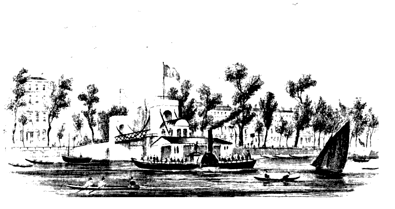
Cadogan Pier with a passenger steamboat with the Pier Hotel (left)
Piers
There was insufficient accommodation on the riverbank for the boats in the 1840s and piers were built into the Thames to accommodate them. Cremorne Gardens had its own landing place, with a regular service from London. (fn. 31) In 1840 Old Swan pier and Chelsea Mall pier served the steamboats, but by 1841 Earl Cadogan had erected Cadogan pier in Cheyne Walk, designed by N. Handford, catering for a large number of summer passengers. (fn. 32) In 1846 Chelsea improvement commission believed that additional piers were still needed, (fn. 33) but provision for piers in plans for the embankment c. 1852 was not put into effect. (fn. 34) Another pier was built east of Battersea Bridge by 1865, (fn. 35) known as Chelsea and later as Carlyle pier; it was presumably rebuilt following completion of the embankment in 1874. (fn. 36) Cadogan pier was also rebuilt c. 1875 to accommodate Albert Bridge. (fn. 37) By 1894 Victoria pier had been put up near the Royal Hospital, just outside the parish's eastern boundary, (fn. 38) but was disused in 1901. (fn. 39) The LCC acquired Cadogan pier from the Thames Conservancy Board and Carlyle pier from the Thames Steamboat Company and repaired them in 1905; passengers travelling higher up the river changed boats at Cadogan pier, but services operated from Carlyle for only a few months. (fn. 40) All three piers survived in 1963, (fn. 41) but only Cadogan pier still stood in 1996 when it was bought by Cadogan Pier (Chelsea) Limited from the Port of London Authority. (fn. 42) Public and private charter services operated from it in 2000.
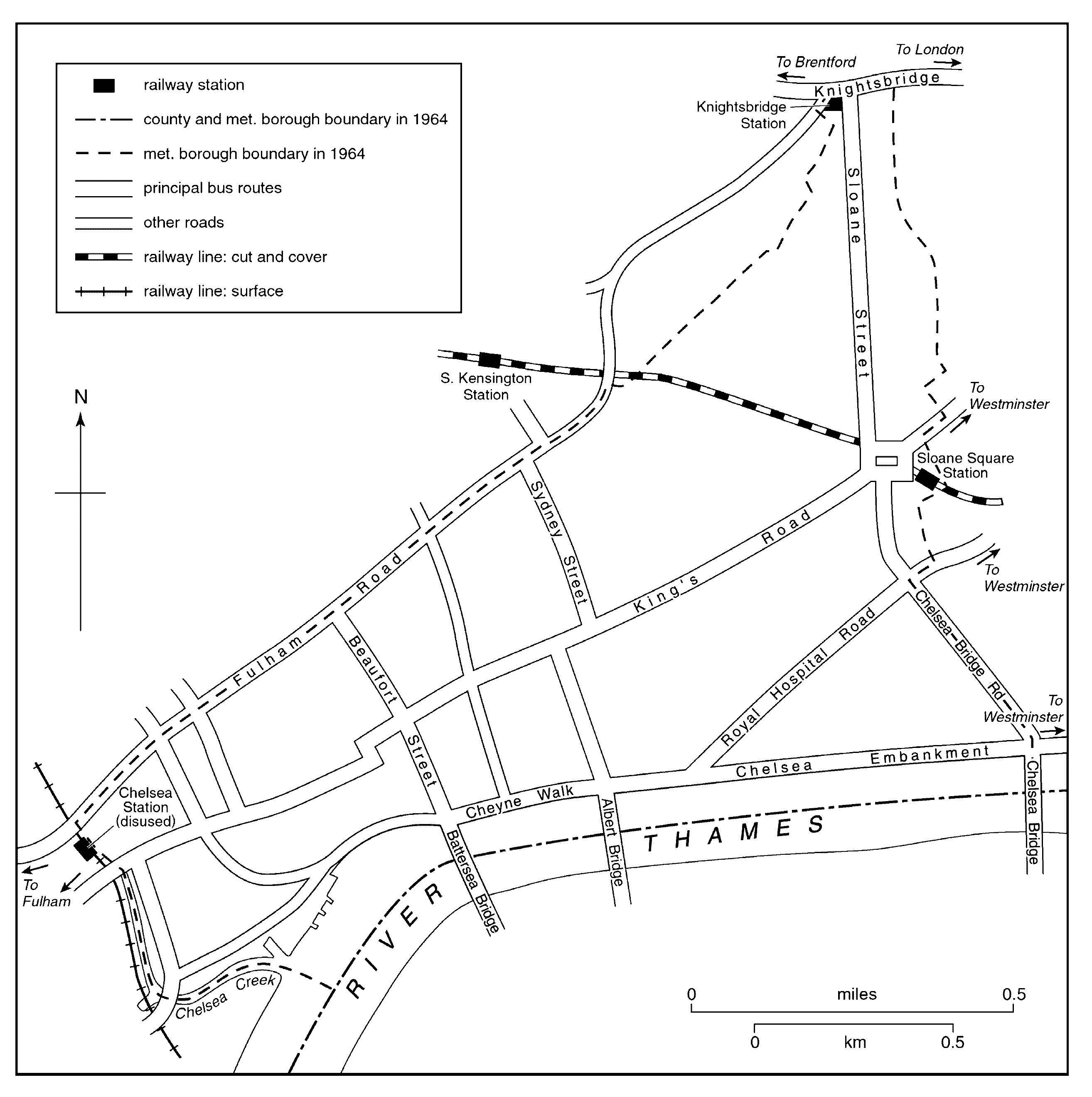
THE MAIN ROADS AND THEIR BRIDGES
Royal Hospital Road
Chelsea village was reached from the east by a road from Ebury and Westminster, presumably that mentioned in 1433. (fn. 43) It ran to the riverside, then turned northward by Chelsea church by 1620 before resuming a western course to Fulham; that latter part was later taken over by the King's Road. (fn. 44) After the Royal Hospital was built, the route in front was diverted northward, westward, and southward around Burton's Court in 1687-8: (fn. 45) the diversion was unpopular and inhabitants claimed a right of way across the Court. When that footway was closed at night in 1761, it added half a mile for pedestrians, and from 1762 Burton's Court was periodically perambulated. There were concerns about the danger of the longer route in 1785, and the Colonnade of the south front of the hospital was used as a public thoroughfare at night, to the annoyance of the Royal Hospital in 1804. In 1816 a new footpath across Burton's Court replaced the existing one, and public use by night of the Colonnade- which the vestry considered safer - was discontinued. However, the desire for a carriage road on that route was not fulfilled until the 1840s. (fn. 46) The closure of the road across Burton's Court in the 1680s meant that by 1836 much traffic to London used the longer route via Sloane Street and Knightsbridge. (fn. 47) The Metropolis Improvements Commission recommended re-opening a route between Royal Hospital Row and Paradise Row, and this was undertaken by Chelsea improvement commission in 1846: the road was called Queen's Road, later changed to Royal Hospital Road. (fn. 48)
Bridges The road from Westminster to Chelsea village was carried over the boundary by a stone bridge, documented from 1587; (fn. 49) it is probably the stone bridge which the vestry paid to mend in 1682. (fn. 50) By the early 19th century a single-arch brick bridge in Grosvenor Row (later Pimlico Road) had replaced the stone one. There was also a bridge over the watercourse at the Cheshire Cheese public house; to the south, a bridge built by the proprietors of Ranelagh gardens was by 1826 inaccessible for public use. (fn. 51)
Another stone bridge, recorded from 1409, is identified as carrying the highway across the western boundary, later Bull bridge or Stanley bridge on the King's Road. (fn. 52) A new bridge stood there at Sandy End by 1717, (fn. 53) in 1826 a single-arch brick bridge said to have been built by the Crown, who had maintained it to that date. (fn. 54) Under its Act Kensington Canal Company completed a new brick bridge in 1826. (fn. 55) In 1908-9 Chelsea MB contributed to the LCC's reconstruction of Stanley Bridge, which by then also crossed the railway. (fn. 56)
Fulham Road
London's major route westward bypassed Chelsea's northern tip at Knightsbridge, (fn. 57) but was connected to the parish by the Fulham Road, which coincided with all but the easterly stretch of the northern parish boundary and ran through the settlement of Little Chelsea. (fn. 58) The way from Fulham to London, presumably that road, was mentioned in 1372. (fn. 59) Parts of the road had various names, for example Little Chelsea Street in 1671, (fn. 60) while the section near Stamford bridge was Bridge Street in 1811. (fn. 61) The highway was connected to Chelsea village by one principal north-south route, Church Lane, and its continuation to Kensington (later Old Church Street) mentioned in 1566. (fn. 62) By 1717 another route (later Milman's Street and Park Walk) also extended from the highway at Little Chelsea to the river, and an irregular route ran from Fulham Road to the Royal Hospital via Blacklands. (fn. 63)
In 1672 the Fulham road had long suffered neglect, but in 1673 Chelsea's inhabitants claimed they could not make repairs owing to the wet season. (fn. 64) In 1687 two surveyors were amerced for not mending the highway from Queen's Elm, presumably to Stamford bridge. In 1689 the inhabitants repaired the highway between Queen's Elm and the King's Gate (presumably between Fulham Road and King's Road) and between Queen's Elm and the Dog Kennel after being presented. (fn. 65) By 1829 the high road had 'become a great thoroughfare', (fn. 66) presumably reflecting increased traffic on this route of long-standing importance.
Stamford Bridge 'Samfordbregge', mentioned in 1410 and referring to a sand ford, carried Fulham Road over Chelsea's western boundary. From 1590 the spurious Stamford and variants occur, and it was sometimes known as Little Chelsea bridge. Repair of the bridge was to be shared equally by the bishop of London and the lord of Chelsea in 1582. (fn. 67) In the early 17th century Sir Walter Cope, who lived in Kensington, enlarged the waterway, (fn. 68) and Stamford bridge (or 'two bridges') was widened. In 1635 inhabitants of Fulham and Chelsea were ordered to repair the bridge but thought that the lord of Kensington and the bishop were responsible, having repaired it for some 40 years; (fn. 69) in 1718 inhabitants complained of its condition. (fn. 70) It was rebuilt with a single arch of brick and stone in 1762 by Kensington turnpike trust, with contributions from the manorial lords of Fulham and Earl's Court, and was maintained thereafter by the trust. The Kensington canal proprietors failed to secure a contribution for rebuilding the ruinous bridge in 1824 as it was not a county bridge, (fn. 71) but it was rebuilt when the canal was made in 1828. (fn. 72) Stamford bridge was rebuilt again in 1860-2 and later partly reconstructed. (fn. 73)
The King's Road
In 1590 a causeway was to be made at Bloody Gate, a footway into the parish from the east. Under Charles II the king's private road, later simply known as King's Road, was formed from Westminster via Chelsea to Hampton Court along the route of this footpath through the fields, taking over an existing road to Fulham at the western end of Chelsea. King's Road was briefly opened to the inhabitants in 1718 while Stamford Bridge was under repair. (fn. 74) In 1719 Sir Hans Sloane led property owners in successfully petitioning for access via King's Road, which had been agreed when the road was formed but denied some years before. The Surveyor of the King's Private Roads argued that 50 to 60 vehicles using the road daily without right had inconvenienced 'persons of quality' under his predecessor; the inhabitants disclaimed knowledge of these 'foreigners'. (fn. 75) Tollhouses built in 1720 included three in Chelsea (north of the Royal Hospital; at Church Lane, later Old Church Street; and at World's End); three years later the keepers petitioned for payment. (fn. 76) Passes to use the road were issued, (fn. 77) and many counterfeits made, so that by 1783 the road was hardly private: the king had also granted permission for local roads to be cut into it, usage could not be limited to gentlemen ticket-holders, and commercial traffic increased, including hackney and stage coaches in the early 19th century. Scuffles between travellers and gatekeepers occurred frequently at junctions between royal and public routes. (fn. 78) A proposal to straighten the line of the road by Millman Row and otherwise improve it in the early 1820s was not carried out, and the three bars also remained. (fn. 79) From c. 1827 the road went unrepaired, and as it was recognized that the road had become public, responsibility was transferred from the Crown to the parish in 1830, which resulted in heavy expense. Controversial attempts by the Grosvenor Place trustees (Westm.) to limit commercial traffic (including omnibuses and stagecoaches) by a bar just outside the eastern boundary of Chelsea, inconveniencing the inhabitants, continued until 1836. (fn. 80) The gatehouse of 1720 north of the Royal Hospital was demolished in 1833, (fn. 81) and from 1843 the vestry, and from 1845 to 1855 the Chelsea improvement commission, solicited funds from the Crown to widen the stretch near the Royal Military Asylum which was too narrow for carriages to pass and lacked a footway: the resulting tendency of pedestrians to keep on the opposite side was said to disadvantage shopkeepers along the entire south side. The work was in progress in 1861. (fn. 82) By 1869 the formerly narrow King's Road had been transformed by numerous improvements. (fn. 83) The road, occupied in the early 19th century by few businesses except nurseries, (fn. 84) became the centre of building and commercial development in the parish, (fn. 85) altering the focus of the settlement away from the river. (fn. 86)
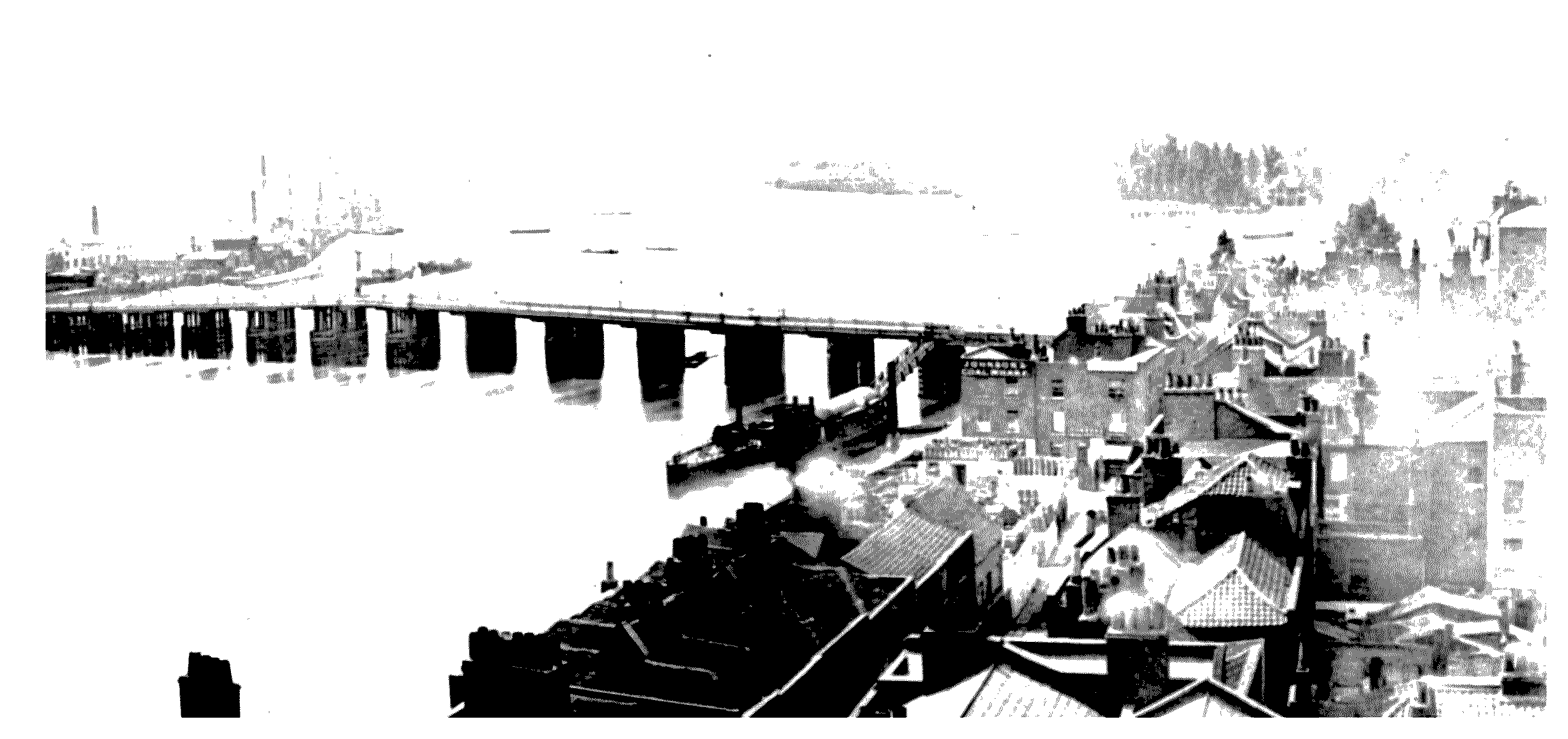
Old Battersea Bridge and Chelsea's riverside houses, before the embankment was built. The buildings and trees of Cremorne Gardens can be seen in the distance (right)
Bloody or Grosvenor bridge (fn. 87) The existing Blandel or Bloody bridge, presumably so-called by 1590, was reconstructed to carry the King's Road over the Westbourne. The single-arch brick structure built by the Office of Works before 1723 survived in 1826; it was later known as Grosvenor bridge. (fn. 88)
Turnpike Trust
An Act of 1725 formed a trust, usually known as the Kensington trust, which from 1726 maintained Chelsea's roads from Knightsbridge to Fulham ferry (Fulham Road); Westminster to Chelsea ferry (later Royal Hospital Road); and Chelsea church to Kensington (later Old Church Street); (fn. 89) turnpike gates were erected at Queen's Elm. (fn. 90) In 1728 the trust maintained almost two miles in Chelsea and around a quarter of a mile at the Royal Hospital, leaving over a mile of Chelsea's roads outside its care. The trustees compounded with Chelsea for £50 and with the Royal Hospital for £8 in lieu of statute work on the roads. (fn. 91) The trust's attempts to dig gravel on Chelsea Common, in dispute from 1726, were thwarted in 1736 by Sir Hans Sloane and other proprietors. (fn. 92) A further Act renewed the trust from 1741 and added Blacklands Lane (later Draycott Avenue), because of its poor condition caused by increased use by carriages. (fn. 93) The trust did not meet all the needs of the parish regarding the roads however. In 1770 the vestry had to get the trust to remedy the bad condition of the turnpiked roads, and in the 1780s Hans Town residents were unsuccessful in getting the trust to take over Sloane Street, though from 1795 the trust paid a composition to the Hans Town commissioners for its repair. (fn. 94) In 1794 the parish considered demanding concessions including watering to counter a feared increase in tolls, but in the event did not oppose the trust's Bill. (fn. 95) In 1825 the trust had gates at Chelsea Bunhouse, Queen's Elm, and Little Chelsea, and under its Act of 1825 set up a new gate in Royal Hospital Row (later part of Royal Hospital Road). (fn. 96) A proposal to replace the trust in 1821 was opposed by Chelsea vestry which was satisfied with its management, (fn. 97) but under an Act of 1826 the Metropolitan Roads Commission (MRC) succeeded the trust. (fn. 98) A Kensington trust post survived in Godfrey Street in 2000.
In 1838 the vestry wanted the MRC to remove the toll gate in Royal Hospital Row, (fn. 99) in 1841 claiming that traffic avoiding the gates there and at Queen's Elm increased the cost of highway repairs. (fn. 100) The Hans Town commission argued in 1844 that the Royal Hospital Row bar diverted traffic onto its roads. (fn. 101) Turnpike gates were removed throughout the parish in 1845. (fn. 102)
RIVER CROSSINGS
Battersea Bridge
Battersea Bridge, the first road to cross the Thames from Chelsea, was built after an Act was obtained in 1766 under John, Earl Spencer. (fn. 103) After a delay apparently caused by disputes among riparian landowners, (fn. 104) a wooden bridge 28 ft wide, paid for by subscription, was built by Mr Phillips, carpenter to George III, to Henry Holland's designs, opening in 1771 for foot passengers and in 1772 for carriages. (fn. 105) A commentator opined in 1771 that a toll-free stone bridge constructed by the Crown would be preferable to the 'mean' wooden bridge of an 'avaricious' proprietor. (fn. 106) The site, west of the ferry landing near Church Lane (later Old Church Street), was thought preferable for river navigation, (fn. 107) though in 1842 Punch thought that the bridge had been built with little regard to those passing under it. (fn. 108) Two piers were later removed to improve navigation. (fn. 109) The Battersea proprietors were compensated when Vauxhall Bridge (1811-16) was constructed, and they opposed proposals to remove tolls on Chelsea Bridge in the 1850s. (fn. 110) They secured a requirement that the Albert Bridge company acquire and maintain Battersea Bridge when Albert Bridge opened (1873). (fn. 111) Under the Metropolis Toll Bridges Act the MBW freed bridges including Battersea in 1879. (fn. 112) In 1883 vehicular use was discontinued. (fn. 113) Under Acts of 1881 and 1884 the MBW was empowered to erect a new bridge: (fn. 114) following demolition of the old bridge, construction began in 1887 of the new five-arch structure 40 ft wide, of iron on granite piers, designed by Sir Joseph Bazalgette; it opened in 1890. (fn. 115) It remained vulnerable to damage from shipping because of strong currents. (fn. 116)
Beaufort Street The Act of 1766 also authorized the creation of approaches to the bridge, probably leading to the building of Beaufort Row c. 1766, as the bridge was planned in line with it. (fn. 117) In 1839 proposed completion of the route between Battersea Bridge and Kensington was to include a road between Camera Street and Fulham Road. (fn. 118) In 1845 the bridge proprietors and improvement commission supported that improvement, the latter blaming the inanimate state of some neighbourhoods on its absence. (fn. 119)
Chelsea Bridge
Although Chelsea Bridge lay just outside the parish boundary, (fn. 120) it is treated here because of its name and significance for parochial communications. (fn. 121) Its site may have been an ancient ford. (fn. 122) The embankment and connecting road proposed in 1845 stimulated a private initiative for a Thames crossing, (fn. 123) also recommended by the Metropolis Improvements Commission, to make Battersea park (Surrey) more accessible. However, an Act of 1846 authorized construction by the Commission of Woods and Forests of a suspension bridge, as being compatible with river navigation. Work on Thomas Page's ornate iron bridge, begun under the Commission of Works in 1851, suffered various interruptions, (fn. 124) and Chelsea Bridge, 47 ft wide, opened in 1858. An attempt in 1857 to prevent the imposition of tolls, thought to negate its usefulness, was unsuccessful, (fn. 125) but an Act of 1858 for the abolition of foot passenger tolls after payment of the capital and interest was amended in 1875 to allow their abolition on Sundays and certain holidays; (fn. 126) all tolls were abolished in 1879. (fn. 127) Doubts about the bridge's strength resulted in modifications in 1863-4, (fn. 128) and periodic repairs included fixing additional chains in 1880; weight restrictions were imposed. The pinnacles on the towers were removed in 1921-2. Usage almost doubled between 1914 and 1929 to over 12,600 vehicles in one day's survey. The royal commission on cross-river traffic in 1926 recommended rebuilding to accommodate all traffic: in 1931 the LCC improvements committee advised reconstruction to give six lanes, and a Ministry of Transport contribution was eventually agreed for a four-lane bridge. Demolition proceeded in 1935. The new self-anchoring steel suspension bridge, 83 ft wide, opened in 1937, a plain design engineered by Rendel, Palmer, & Tritton, with the LCC architect G. Topham Forrest (succeeded by E.P. Wheeler in 1935); the Royal Fine Art Commission was also consulted. (fn. 129) Circa 1961 the bridge carried c. 16,000 vehicles a day. (fn. 130)
Chelsea Bridge Road Following the Metropolis Improvements Commission's recommendation in 1845 for a road to the proposed embankment, (fn. 131) an Act of 1846 empowered the Commissioners of Woods and Forests to form it, (fn. 132) but the line was only prepared in 1854, to join the embankment at Chelsea Bridge, and the road, originally called Bridge Road, was laid out in 1857-8 to James Pennethorne's designs. (fn. 133) The vestry took over its section of the road in 1862 following unsuccessful demands that the Office of Works pave the footpath. (fn. 134)
Albert Bridge
Proposals for a bridge between Cheyne Walk and Battersea were made from at least 1842, (fn. 135) but a scheme of 1843 was apparently transferred to form the original proposal for Chelsea Bridge. (fn. 136) The proposal to build Albert Bridge eventually secured its Act in 1864, although further Acts were necessary in 1869, 1871, and 1873; (fn. 137) construction was delayed by arrangements for the embankment. (fn. 138) Work progressed from 1870 on an earlier plan for an ornate three-span iron bridge by R.M. Ordish, supported by rigid bands radiating from the towers, according to his patented system; it opened in 1873. (fn. 139) Tolls were abolished in 1879. (fn. 140) Alterations planned by Sir Joseph Bazalgette, which involved adding new chains, were carried out by the MBW in 1887. (fn. 141) A five-ton weight limit was imposed in 1935 and a two-ton limit c. 1970. Proposed replacement by the LCC met opposition in 1957, and the GLC's proposal to prop the central span provoked debate about whether the bridge should be replaced, maintained for motor traffic, or reserved for pedestrians. Supporting piers were inserted in 1972. (fn. 142) A public inquiry of 1974 considered closure to vehicles, (fn. 143) but the bridge stayed open.
NEW MAJOR ROUTES
Thames Embankment
The riverbank was an uncertain responsibility in 1685. Disputes between the manorial lord and tenants, parish, turnpike trust, and neighbouring householders often left the walls out of repair. In 1815 the vestry required the lord and neighbouring freeholders to repair the dangerous wall opposite Lindsey Row (later part of Cheyne Walk) and Millman Row (later Milman's Street). Although the turnpike trust's claim that the lord of the manor was responsible for repairs was upheld in 1822, the question was not finally resolved. By 1829, however, the walls were repaired and the trust had improved the road and paved some footpaths. A long-standing scheme to widen Cheyne Walk by extending the embankment into the river, which would include removal of buildings south of Lombard Street and Duke Street (east of Battersea Bridge), was again considered in 1829 but not carried out. (fn. 144) In 1836 the vestry suggested improving the route from Battersea Bridge via the riverside and Royal Hospital to Westminster, as communication from lower Chelsea was inconvenient and lowered property values, and also suggested a new riverside route between Chelsea and Fulham, proposals which had local support. (fn. 145)
A proposal was drawn up in 1839 for embanking the north shore of the Thames between Vauxhall Bridge and Battersea Bridge, which would aid navigation and sanitation, provide a riverside road improving communications and opportunities for recreation, and benefit neighbouring areas. This was considered by the Metropolis Improvements Commission in 1843, and plans prepared by its engineer, Thomas Page, in 1845. Chelsea vestry supported the proposal, believing the embankment, which it wanted continued to Fulham, would stimulate other improvements. (fn. 146) The Commissioners of Woods and Forests were empowered to form the embankment, but as agreement was not reached with some proprietors the work was deferred. (fn. 147) The Commissioners of Works were substituted in 1852, but only empowered to construct an embankment as far as Chelsea Hospital's western boundary. (fn. 148) Chelsea improvement commission, however, campaigned for the full scheme, highlighting the inadequacy of communications, which were blamed for the defective condition of much of Chelsea, and arguing that the parish's improvement Act had been founded on the expectation of the full embankment. (fn. 149) The partial embankment was made c. 1853-7; foul mudbanks remained west of Battersea Bridge in 1859. (fn. 150) The embankment terminated with a turning place (which survived in 2001) in front of the Royal Hospital, just inside the parish boundary.
The MBW pressed to extend the embankment to Battersea Bridge, resulting in the Thames Embankment (Chelsea) Act, 1868. Engineered by Joseph William Bazalgette, the new embankment was built 1871-4, reclaiming 9½ acres from the river and extending three quarters of a mile with a 70 foot-wide road and river wall faced with hammer-dressed granite. The original route survives as Cheyne Walk. It transformed the riverside, involving the demolition of buildings south of Duke Street and Lombard Street (including Arch House which spanned the latter), and the removal of wharves and stairs: the MBW made three new sets of stairs c. 1875 on the river wall in lieu of former landing places. (fn. 151) When it opened, the embankment became an agreeable promenade for carriages and pedestrians, (fn. 152) but in separating Chelsea from the river it altered the focus of the parish and by the early 20th century its creation had become a source of regret. (fn. 153)
The vestry made several attempts to get the embankment extended still further: from 1872 they urged the MBW to extend it to Cremorne, and from 1889 they solicited extension by the LCC, to improve the narrow thoroughfare west of Battersea Bridge and remove unhealthy accumulations in the river. A vestry contribution was eventually agreed in 1896, but some inhabitants opposed the plan, and a parliamentary committee rejected it in the LCC (Improvements) Bill of 1897, principally on aesthetic grounds. The vestry continued to support the scheme. (fn. 154)
The growth in motor traffic in the 20th century led to proposals for new or enhanced routes through Chelsea, one of them along the riverside. By 1931 the Chelsea Society was concerned by the volume of traffic on the embankment which had become an arterial route through London, (fn. 155) but the Bressey report in 1937 advocated its extension to Putney Bridge to relieve other westbound routes in Chelsea and Fulham, a scheme which would have had far wider effects than the one of 1889. The subject again featured in the LCC plan of 1943. In 1951 the borough council's proposal to embank the stretch west of Battersea Bridge towards Lots Road, and perhaps to Fulham, was opposed by the Chelsea Society and others. The council rebuilt the river wall along the existing alignment in 1953-4, (fn. 156) but in 1954 it was felt unfair that it should have to maintain roads like Chelsea Embankment, which carried heavy through traffic but were of little local use. (fn. 157)
West Cross Route
The growth in motor traffic also led to proposals for a new route on Chelsea's western boundary. From 1951 a west cross route for Greater London was proposed to run north-south near the boundary to relieve Kensington and Chelsea, and from 1965 this was to form the western side of a larger motorway network (Ringway I) projected by the GLC. However, without a Thames crossing it was unacceptable to Chelsea residents, who feared that the traffic would be decanted onto Chelsea Embankment, and after a public inquiry in 1972 concluded that benefits would not justify the detrimental effects, planning permission was refused. A similar scheme in 1978 raised similar fears, but was scrapped in 1981. (fn. 158)
PUBLIC ROAD TRANSPORT
Coach Services
In 1822 coaches operated from Chelsea to St Paul's, the Strand, Charing Cross, Fleet Street, and Coventry Street (Leicester Sq.). (fn. 159) The caricaturist Thomas Rowlandson drew the Chelsea stagecoach at Paradise Row (later part of Royal Hospital Road) in 1824. (fn. 160) In 1825 ten coaches operated on the short stagecoach route from the City which terminated at Chelsea, making 25 return journeys a day. (fn. 161) In 1826-7 six operators ran coaches from Chelsea, ranging from twice to five times daily. (fn. 162) The stagecoaches started from Lawrence Street and Old Church Street, where there was extensive stabling. (fn. 163)
Omnibuses
In 1835 two omnibus conductors on a Chancery Lane-Chelsea route fought over the custom of two servant girls. (fn. 164) In 1838-9 ten omnibuses were licensed to run between Blackwall and Sloane Street and one between West Ham and Sloane Street; two between Bromley and Chelsea; one each to Bank, Leadenhall Street, and Whitechapel church; and 27 to Mile End Gate. (fn. 165) Traffic which in 1830 was carried on by 18 coaches (out and back) making 108 journeys daily was by 1845 operated by 72 omnibuses making 694 journeys. (fn. 166) The removal of turnpike gates throughout the parish in 1845 included that at Queen's Elm, enabling omnibuses to proceed beyond Brompton to Little Chelsea. (fn. 167)
The Man in the Moon was the starting place for the Chelsea and Brompton omnibuses, also allowed to wait at the Goat in Boots (Little Chelsea) and at the Cricketers (Cheyne Walk). (fn. 168) In 1847 the improvement commission allowed the Hoxton and Holborn omnibuses to start from the Colvill tavern (King's Road). (fn. 169) By 1857 omnibuses to Chelsea ran every five minutes from Hoxton, Bethnal Green, and Bank, via Fleet Street and Piccadilly; and from Angel (Islington) via New (later Euston) Road and Regent Street. (fn. 170)
In 1856 68 omnibuses were delivered to the London General Omnibus Company (L.G.O.C.) for routes having Chelsea or Sloane Street as a terminus. The L.G.O.C. had a depot and stabling at Chelsea, where in 1857-8 large-scale processing of horse feed began, (fn. 171) and also several cab-yards in Lawrence Street in 1900. (fn. 172) L.G.O.C. premises at the east end of Lots Road dated from 1894. (fn. 173) In 1952 it also had a training school and catering department in Milman's Street. (fn. 174)
In 1911 the L.G.O.C. ran three routes along Fulham Road (nos 5, 14, 15) and two along King's Road (nos 11, 19). In 1913 there were also buses along Edith Grove, Sydney Street, Oakley Street, and along the Embankment to Battersea Bridge, and by 1930 additions ran along Royal Hospital Road. Nine daytime routes served Chelsea in 1937. (fn. 175) From c. 1987 the C1 minibus service between Westminster and High Street Kensington ran via Sloane Square and Knightsbridge. (fn. 176) Eleven routes served Chelsea in 1993. (fn. 177)
Trams
Tramways were not introduced when first suggested, (fn. 178) and in 1878 the vestry opposed proposals for various routes through Chelsea: local opinion was particularly against the Chelsea Embankment and Royal Hospital Road route, fearing noise, damage to roads and annoyance to other users, and the impact on residences and recreational use of the embankment. (fn. 179) Further abortive proposals were made in the 1880s. (fn. 180) The LCC were empowered to construct a tramway from Battersea to the junction of Beaufort Street and King's Road in 1909: lines were laid over Battersea Bridge and the electrified route, no. 34, operated from 1911. In 1933 weekday services to and from south London operated about every four minutes. (fn. 181) In 1937 the London Passenger Transport Board sought powers to extend the route, for use by trolleybuses, to Fulham Road, returning via residential roads. Residents and Chelsea MB opposed the scheme, but an alternative via Paultons Square and Danvers Street was also unpopular and the scheme was dropped. (fn. 182) Trams continued to operate until the no. 45 motorbus replaced route 34 in 1950. (fn. 183)
CANAL AND RAILWAYS
Kensington Canal
Counter's Creek, also known as Chelsea Creek, the New Cut River, or Bull Creek, was the parish's western boundary. (fn. 184) Sir Walter Cope widened the river, presumably while living at Kensington, 1607-14, to the inhabitants' benefit, (fn. 185) and in 1673 Chelsea landowners were presented for failing to scour the watercourse, used by vessels from the Thames. (fn. 186) Canalization of the creek by a private company was authorized under Acts of 1824 and 1826, and the Kensington canal opened in 1828 with capacity for craft of 100 tons. (fn. 187) However traffic was poor, and the Birmingham, Bristol, and Thames Junction (after 1840 the West London) Railway was incorporated in 1836 to build a railway line over the northern stretch, outside Chelsea. (fn. 188) The company took the canal over, its muddy condition a source of concern. After the West London Extension Railway company was formed in 1859 the canal was transferred to it, and the section north of King's Road was used for the line in 1863 (below). The southern stretch remained in use by businesses with wharves along its banks. It passed to the British Transport Commission after nationalization in 1947. Right of navigation from King's Road southward to the gasworks dock in Fulham was extinguished in 1959, and a dam was formed. From 1963 the remaining stretch was managed by the British Waterways Board, but after 1967 traffic was minimal. The borough council's proposal in 1981 to fill in the derelict stretch between King's Road and the dam provoked opposition, (fn. 189) but by 2001 a stretch south of King's Road had been filled.
Railways
The West London railway built 1844 between the Great Western and London and North-Western lines in Willesden and the canal basin at Kensington was not a success, and in 1859 the two companies, with the London and South-Western and the London, Brighton, and South Coast Railway, promoted its extension to Clapham Junction. The line built in 1863 along the canal by the ensuing company, the West London Extension Railway, ran close to Chelsea's western edge with a stretch south of King's Road within the parish, but the line diverged from the boundary towards the Thames; Chelsea station, between Fulham and King's roads, was mostly outside the parish. (fn. 190) It was served from 1863 but the fabric apparently dated from 1866; (fn. 191) there may have been rebuilding in 1883. (fn. 192) The station was renamed Chelsea and Fulham from 1903. (fn. 193) The route, connecting northern and southern lines, was important for freight traffic; through passenger services operated only from 1904, and were not extensive. The line also catered for suburban passengers, (fn. 194) but suffered from competition with other modes of transport, and passenger services ceased in 1940, when Chelsea and Fulham station closed; (fn. 195) it was mostly demolished c. 1955. Freight traffic continued and from the 1960s use of the line for through passenger routes increased. (fn. 196)
Underground Railways
The Metropolitan District Railway Company opened the South Kensington-Westminster stretch of the District line in 1868, (fn. 197) with a station at Sloane Square on Chelsea's eastern boundary. (fn. 198) The line was electrified in 1905. (fn. 199) The station, which served some 150,000 passengers a week, was remodelled in 1940 to include a new ticket hall and escalators, (fn. 200) but was bombed later in 1940 and reconstructed in 1951. (fn. 201) The flats above ground level, by R. Seifert & Partners, were added in 1965. (fn. 202) The line was among London's busiest in 1985 with 24 trains an hour rising to 36 in peak periods. (fn. 203)
Proposals for tube lines through Chelsea c. 1901 failed, (fn. 204) but the northern end of the parish was served by the Piccadilly line's Knightsbridge station just outside the parish boundary, which opened in 1906; an entrance and ticket hall at the corner of Sloane Street opened in 1934. (fn. 205)
In 1989 the Central London Rail Study proposed a scheme for a Chelsea-Hackney line, (fn. 206) which was still awaiting financial backing in 2003.
Lots Road Power Station, on nearly 4 acres just east of the mouth of Chelsea Creek previously occupied by wharves, was built to supply the power which enabled the electrification of the Metropolitan District Railway, and also powered three other lines which formed the Underground Electric Railways Company of London (in 2000 the Northern, Bakerloo, and Piccadilly lines), controlled by the American financier Charles Tyson Yerkes. When built (1902-4) it was the largest electric traction station in the world. The 453-ft long structure in neo-classical style, probably designed by the company's engineer J.R. Chapman with its architect Leslie Green, comprised a steel frame clad in brickwork with terracotta detailing, enlivened by large glazed arches and four 275-ft chimneys. Boilers, fed with coal brought up the Thames and later also by rail, supplied steam to turbo-generators in the adjoining turbine hall. The station began supply in 1905. Current was distributed via Earl's Court station to substations in various parts of London. Reconstruction from 1927 renewed the machinery and increased capacity. Operated by the London Passenger Transport Board, in 1937 Lots Road supplied electricity to much of the Underground and to trams and trolleybuses. Following nationalization in 1948 the power station was controlled by London Transport. Further modernization (1963-9) included a change from coal to fuel oil, and two of the chimneys were removed in 1966. Gas replaced fuel oil in 1975. (fn. 207) In 2000 the power station was due to be decommissioned in 2001, and it finally shut down in October 2002, its output being replaced by electricity from the National Grid. Conversion to residential use was planned for the building. (fn. 207)