A History of the County of Middlesex: Volume 12, Chelsea. Originally published by Victoria County History, London, 2004.
This free content was digitised by double rekeying. All rights reserved.
'Settlement and building: Chelsea up to 1680', in A History of the County of Middlesex: Volume 12, Chelsea, ed. Patricia E C Croot (London, 2004), British History Online https://www.british-history.ac.uk/vch/middx/vol12/pp14-26 [accessed 2 May 2025].
'Settlement and building: Chelsea up to 1680', in A History of the County of Middlesex: Volume 12, Chelsea. Edited by Patricia E C Croot (London, 2004), British History Online, accessed May 2, 2025, https://www.british-history.ac.uk/vch/middx/vol12/pp14-26.
"Settlement and building: Chelsea up to 1680". A History of the County of Middlesex: Volume 12, Chelsea. Ed. Patricia E C Croot (London, 2004), British History Online. Web. 2 May 2025. https://www.british-history.ac.uk/vch/middx/vol12/pp14-26.
In this section
CHELSEA UP TO 1680
Evidence for prehistoric settlement in Chelsea has in the past largely consisted of finds taken from the Thames, such as an elegant Neolithic flint sickle, indicating harvesting in the area, and an early Neolithic wooden club, resembling a cricket bat with a rounded handle and a knob, which was found just west of Battersea Bridge and dated to 3540-3360 BC; several flint axes have also been retrieved. (fn. 1) More recent excavations have found flint flakes and burnt flint near Chelsea common, and worked flints and pottery fragments, probably from the Late Bronze Age, and other prehistoric material in later features near Chelsea Old Church. Similarly, Roman material has been found in later features on the east side of the church, and a Roman ditch with Roman pottery of the 3rd century AD on the north side. (fn. 2)
ANGLO-SAXON CHELSEA
Chelsea's Old English name may indicate some kind of settlement in the early Anglo-Saxon period, (fn. 3) but more concrete evidence of settlement emerges in the 8th century. Chelsea, first mentioned in 785, is one of the few places in Middlesex to have a recorded history before 1066. (fn. 4) Ten synods of the English Church were held there between 785 and 816, some of them also meetings of the Mercian royal council, (fn. 5) and other, unrecorded, church councils may have met there, probably also in the half century after 770. The synods were meetings of the province of Canterbury and as such promulgated canons for the whole of England south of the Humber, that of 816 being of special importance. They coincided with the ascendancy of the Mercian kings and are part of a wider pattern of holding such meetings within the diocese of London, and more particularly within the area of the ancient kingdom of Middlesex. (fn. 6) Though the presence of church councils does not necessarily mean the existence of a minster church in Chelsea, the Mercian kings, notably Offa, Egfrith, and Coenwulf, whose reigns covered the period 757-821, were frequently at Chelsea and are thought to have had a residence there. (fn. 7) A possible link between Chelsea and these kings is suggested by the name given to a detached portion of Chelsea parish lying north of Kensington: Kensal derives from the Old English cyning holt, 'king's wood'. (fn. 8) Given the small area of Chelsea and the seemingly artificial boundary separating it from Kensington along the line of Fulham Road, it seems likely that the whole of the territory had once formed a single unit. The hypothesis is given some support by the presence of a small detached portion of Kensington parish by the river, later in the grounds of the Royal Hospital. (fn. 9) Charters granting estates to church and laity were sometimes recorded as having been issued at Chelsea, although the only remotely local properties involved were Stanmore in 793, (fn. 10) and Harrow c. 800. (fn. 11)
In 898 Chelsea was the scene of a council attended by King Alfred, Archbishop Plegmund of Canterbury, Aethelred the leader of the Mercians and his sister Aethelflaed, and Bishop Waerferth of Worcester, concerning the refounding of London after the Danish wars. At that council adjacent lots of land at 'Aethelred's hyth' (Queenhythe) within the city were granted to Plegmund and Waerferth. The presence of Aethelred and Aethelflaed and the name of the wharf suggest that the Mercian rulers played an important role, and also suggests that the Mercian royal house had an important estate at Chelsea, which served for meetings in their dealings with the Church and London. (fn. 12)
Chelsea's attraction for Offa and his successors lay in its convenient riverside site and its proximity to the important trading centre of London, (fn. 16) which could be reached easily by water; it also lay close to Roman roads from London to the west and south-west. (fn. 17) Fertile riverside sites such as Chelsea were also attractive to more ordinary residents, however, and some archaeological evidence now exists for pre-Conquest settlement in Chelsea, particularly near Chelsea Old Church. On the east side of Old Church Street, at the rear of nos 6-16, some mid Saxon features have been found with a possible timber structure which may date from the same period, and also a Saxo-Norman ditch, possibly indicating continuity of use of that site, which in the medieval period was part of the manor house and its grounds and outbuildings. (fn. 18) Timbers found in 1996 in the Thames about 40 m. from the shore just west of Battersea Bridge, dating from the period 700-900 AD, were at first thought to be part of a mid Saxon wharf, but on further examination were reinterpreted as an Anglo-Saxon fish-trap. (fn. 19)
MEDIEVAL CHELSEA
The Anglo-Saxon settlement by the church and the river remained the heart of the only known area of settlement in the parish until the 17th century. Most of the parish was covered by two large open arable fields, Eastfield and Westfield, with Church Lane marking the division between them. A single reference to the north field (fn. 13) may refer to the westerly part of Eastfield, which lay north of the village. Within Eastfield were areas called Gosepool, found in the later furlong name of Gospelshot, adjoining the Westbourne, and Thamesshot also in the south-east; the location of Medshot and Crosshot in Eastfield are not known. (fn. 14) In the north-eastern part of the parish lay closes known by 1393 as Blacklands, (fn. 15) and closes called Landmedes, which lay next to Gospelshot and so probably lay between that part of Eastfield and Blacklands. The name does not appear in records after the 15th century and the closes, at least five in 1454 of which two contained 20 acres, were probably later also known as Blacklands, and may have been the area called Bloody Meadow c. 1700. Other meadows lay at Eastmead, probably in the south-east corner of the parish by the Thames and the Westbourne, where Thamesmead lay in the early 17th century, and in Westfield, where West meadow lay, in the south-west corner of the parish by Counter's Creek. Next to it by the creek and the Thames was the common meadow called the Lots, divided into portions of about a quarter of an acre each.
The existence of the celebrated 'great houses' of Chelsea and their occupants in the 16th century and later has overshadowed the community that existed there earlier. Alongside the famous and the outsiders Chelsea had several long-established families owning and working land, many of them also involved in trades and crafts. (fn. 20) By 1300 locals were seeking opportunities elsewhere: a spurrier and two tanners in London had Chelsea as a surname. (fn. 21) The population was probably small, however, for in 1334 Chelsea had the lowest total assessment, at £1 15s. 4d., in the hundred of Ossulstone. (fn. 22)
Though less is known about the residents of Chelsea in the Middle Ages compared with later periods, there are several indications of the presence of important figures in the parish well before the arrival of Thomas More and Henry VIII in the 16th century, and it is probable that from an early period Chelsea attracted the nobility, gentry, and court officials who wanted country houses near Westminster, especially those accessible by river. Letters and orders of Edward I dated at Chelsea in 1294 and 1305 suggest either the presence of the king or at least of his chancellor, and the king's brother, Edmund, also dated a letter at Chelsea in that period. (fn. 23) Thomas Beauchamp, earl of Warwick, wrote his will at Chelsea in September 1369 before going to France, and also wrote a letter there dated in January of an unknown year, (fn. 24) suggesting either periodic visits or a period of residency. The 'lord of Latymer', whose servant was presented at the manor court in 1374 for drawing blood, (fn. 25) may also have been resident rather than passing through. By the end of the 14th century a number of London citizens and professional men not only owned land in the parish but also had houses there. John Haverbarght, holder of a rectory in Lichfield diocese, was buried in the parish church and left 2 quarters of barley to the priest; Master Nicholas Stoket, a free tenant of the manor, was buried in the parish church, (fn. 26) and at least one lord of the manor was often resident and was buried in the parish: John Shoreditch junior and his wife Helen were both buried in the church in Shoreditch's chapel on the north side of the chancel. (fn. 27) During the 15th century the number of residents with occupations in the City of London or in the law courts and royal administration increased, though for most the location of their houses is unknown. Thomas Garthorp, citizen and fishmonger of London, died in 1412 holding lands in Chelsea; (fn. 28) John Aleyn, citizen and vintner, died c. 1449 leaving sums to both Chelsea and Kensington for tithes, for the church buildings, and for the poor; (fn. 29) and Reginald Boulers, bishop of Coventry and Lichfield, left a house in Chelsea to be sold in 1459. (fn. 30) John Palyng, citizen and goldsmith, died c. 1428 with property in Chelsea, (fn. 31) and one of his executors, John Frenshe, also a goldsmith, had a holding in Chelsea by 1447. Frenshe paid 12s. 10d. assized rent in 1453, (fn. 32) so it is almost certain that his house was one of those with commoning rights in the 17th century, (fn. 33) and it was evidently a house of some importance, since by 1464 the holder was Richard Beauchamp, bishop of Salisbury, (fn. 34) who died in possession of it in 1481: the duchess of Somerset, a distant cousin of the bishop's, was living there in 1477. (fn. 35) John Beauchamp, Lord Beauchamp of Powick (d. 1475), bequeathed a pair of organs he had left in Chelsea church towards his funeral in Worcester: he was a first cousin of the bishop of Salisbury and may also have lived in his house. (fn. 36) In 1484 Elizabeth Mowbray, the widowed duchess of Norfolk, was granted that property for life. (fn. 37) Sir Thomas Haseley (d. c. 1450), chancery clerk of the Crown, had an estate in Chelsea with a house which included a chapel and may have been sited not far from the rectory at the west end of the village. (fn. 38) In 1453 his widow Agnes paid the highest of the assized rents. (fn. 39) In 1465 Master Robert Kirkham, chancery clerk and Master of the Rolls, acquired a newly-built house in Chelsea from Haseley's successor, and leased some land there. (fn. 40) William Berkeley, Earl Marshal and marquess of Berkeley (d. 1491), had freehold property in Chelsea which he left to his wife for life and then to John Whiting, one of his supervisors. (fn. 41) Many of the freeholders in the parish were similar outsiders building up estates in Chelsea and Kensington.
MEDIEVAL HOUSES
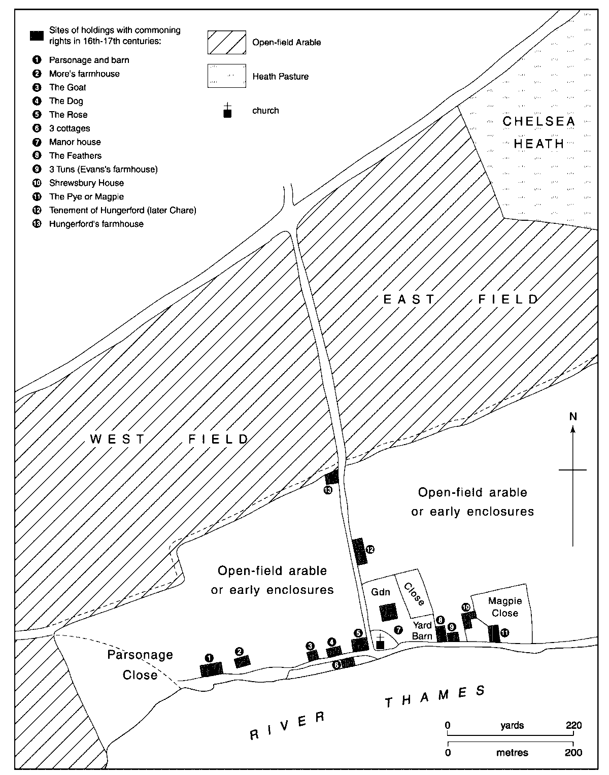
The core of the medieval village lay around the church. On the north and east sides of the church lay the manor house with gardens, courtyard and outbuildings, which with an adjoining close covered a compact area of 4 acres. The close lay on the east side of the site, north of Lordship Yard, probably with stables and outbuildings in the Yard to the south: yet further south stood a wharf by the Thames which belonged to the house in the 1630s, (fn. 42) and doubtless earlier. This all suggests that the manor house itself lay on the western side of the site, perhaps with a main entrance into Church Lane rather than by the riverside; there was a passage through from Church Lane into Lawrence Street just north of the church in 1706. (fn. 43) The belief that the manor house lay on the site of houses known in the 18th century as Monmouth House, at the north end of the later Lawrence Street, is unfounded: that narrow site adjoined the boundary pale of the manor house property and would be an unlikely location for the main house.
The medieval parsonage, mentioned in 1388 but implied in 1230 from the existence of a rector, (fn. 44) is presumably the one replaced in 1566 by a new house and land north of the medieval manor house. It lay strangely distant from the church, at the western extremity of the riverside road through Chelsea, and almost certainly fronted that road and the Thames, so it probably lay at the southern end of the present Milman's Street with Parsonage Close lying north and west of it. (fn. 45) The rector had a wharf on the Thames, presumably near to the house.
Plan of the medieval village, showing probable house sites
Houses which had rights of common of pasture in the late 16th and 17th centuries were almost certainly medieval in origin. The old parsonage had such rights which were transferred to the new one in the 16th century, but there is no evidence that other rights were transferred, though some may have been divided between parts of a property. Although obscure, the link between the assized rents and commoning does at least give some indication of the whereabouts of the main medieval houses. The other properties with such rights were the farmhouse on More's estate, later Lindsey House; a tenement belonging to Hungerford, later the Chare family's property, on the north side of the medieval manor house in Church Lane; the farmhouse on Hungerford's estate, later known as Wrennall's farm, opposite the new parsonage; the Pye or Magpie, next to Winchester House; Shrewsbury House; the Feathers next to Lordship Yard; the Goat in Duke Street by Danvers House; the Dog in Lombard Street with Waterman's Court; cottages next to the Dog owned by Thomas Creake in 1616; and the freeholding later known as Evans's farm, which may also have been near Lordship Yard. (fn. 46)
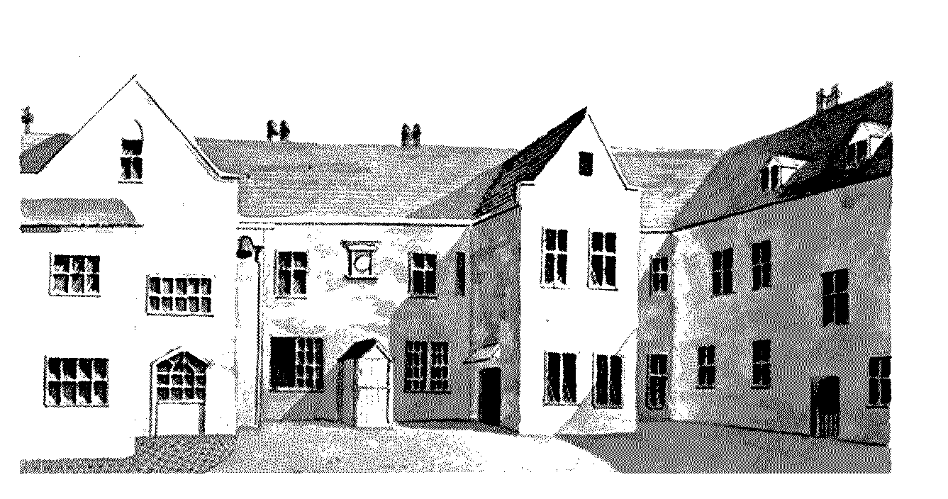
Shrewsbury House, from the south
The river also played an important part in Chelsea's life in the Middle Ages. Chance references, such as four people falling from a boat at Chelsea in 1235, (fn. 47) or the flooding which bought a drifting boat into the manor in 1379, (fn. 48) reveal little of how important river transport may have been at that time, nor how the river was used by Chelsea's inhabitants, but the wharves belonging to several individuals, mentioned from the 14th century, show a strong permanent link with the river. In the 15th century, and probably earlier, the availability of the river to reach London was probably a factor in attracting royal officials, lawyers, and London merchants to seek a residence in Chelsea: this was certainly the case in the 16th century.
16TH AND 17TH CENTURIES
Chelsea was one of a number of villages around Westminster which were popular in the 16th and 17th centuries with courtiers and royal officials who needed suitable residences near Whitehall but who could not find space in the limited and increasingly overcrowded settlement of Tudor Westminster. Alongside the famous, however, Chelsea also had an increasing population of farmers, craftsmen, and those providing food and services to the population, such as brewers and victuallers. In 1528 the population of Chelsea was reported to be 190 adults and children, including 16 households which grew no corn, and Sir Thomas More reported that 100 were fed daily in his household, (fn. 49) though not all those would have been living in the parish. In 1548 there were 75 communicants (16 years and over). (fn. 50)
The evidence for new building to accommodate increased demand is limited, but some older houses were undoubtedly enlarged or improved: illustrations of Shrewsbury House, for example, indicate an earlier timber-framed building refronted in brick in the Tudor period. Since few old buildings survive in Chelsea, and none of those are from the 16th century, the evidence for Chelsea's medieval and early modern houses is slight. Until the end of the 17th century, new building which took place in Chelsea was almost all on existing house sites or gardens or small plots of land associated with existing houses, and this limited both the number and the quality and size of individual houses. Even when building took place on new sites c. 1700 the new building tended to be ribbon development along existing roads, with only a few, very short, new streets. (fn. 51)
While a handful of farmhouses and mansions were built by the early 17th century along Fulham Road at Little Chelsea, inclosing open field as gardens, (fn. 52) the main settlement at Chelsea remained concentrated in the limited area of Chelsea village, in Church Lane and along the riverside. Two houses in particular played an important part in Chelsea's fame, but both are surrounded by some doubt.
HENRY VIII AND CHELSEA
Henry VIII's desire to live at Chelsea has always been emphasized by local historians. A visit he made to Sir Thomas More's house there is held to have inspired him with a love of the place, so that he obtained the manor from William Lord Sandys in an exchange to provide, it is said, a suitable nursery for his children. When he discovered that the manor house had been leased out he built, so the tradition goes, a new manor house, usually called Chelsea Place, a little to the east. (fn. 53) This tradition, however, exaggerates Henry's connection with Chelsea and in particular with the building of the manor house. It is clear that a manor house, which had been built a little to the east of the original one and possibly on a virgin site, was standing before Lord Sandys granted the manor to Henry VIII in 1536, because the Pye, a house which lay on the west side of it, was described as lying next to Lord Sandys' place, as late as 1538. (fn. 54) The Tudor house had probably been built by 1519, when the original manor house was leased out, and it is most likely to have been built by Sandys or his predecessor as owner of the manor, Sir Reginald Bray. (fn. 55)
There are also several anomalies in the traditional account of Henry and Chelsea. In fact, he showed little interest in getting a house there, disregarding More's own house, which had been forfeited to the king in 1535. The impetus for the exchange of property with Sandys may even have come from Sandys himself, who thereby acquired Mottisfont priory, which lay near his main seat and on which he lavished time and money and made his main residence to the end of his life. (fn. 56) Chelsea manor was one of several manors and houses acquired by the king by exchange or forfeit: during the period 1535-40 alone he acquired 15 such properties. The considerable work carried out on some former monastic properties, which provided staging posts on his journeys around the country, was dwarfed by the enormous alterations and additions at the King's principal houses, Greenwich, Whitehall, and Hampton Court. (fn. 57) No major building work was recorded at Chelsea, casting doubt on the tradition that Henry built the Tudor manor house. (fn. 58) It is most unlikely that Henry had anything in mind for the house when he first acquired it. The idea that he wanted to use the house as a nursery for his children apparently stems from the heading 'Chelsea Nursery' in one account for repairs in 1601, possibly a reference to the garden, and a statement in a letter by Sir John Lawrence in 1621 that Henry VIII built a nursery in Chelsea. (fn. 59) The places of residence of the royal children are very well documented, and there is no contemporary indication that Henry ever intended to use Chelsea as a nursery, nor that the royal children were ever resident there during his lifetime. (fn. 60)
Only in 1538 is there any evidence of interest by Henry in the house, when he made his only recorded visit to the parish since acquiring the manor, travelling from Hampton Court to Chelsea by river in May 1538, but only remaining a couple of days. (fn. 61) In July of that year the French ambassador wrote from Chelsea that Henry VIII had given him a house which had belonged to the late Master More for the summer, to avoid the plague in London, and that in the same village was lodged 'my lord privy seal' (Thomas Cromwell). Cromwell, who also dated letters there in June and July, (fn. 62) was probably occupying the king's house in order to avoid the plague also. It may be no coincidence that in that year the king bought the adjoining Pye from a freeholder, almost certainly to add more land on the west side of the house, as the Pye had a close attached. (fn. 63) The accounts for the garden that year (fn. 64) suggest that Henry may have had improvements in mind, but he does not seem to have spent any time in residence. In May 1541 Queen Katharine Howard and Princess Elizabeth are recorded as travelling by barge to and from Chelsea on various occasions, (fn. 65) and the king may have used Chelsea as a convenient stopping place on the river for journeys to Hampton Court, or as a pleasant garden to visit during the summer. Nevertheless, Henry's connection with Chelsea, however slight, was an important one for Chelsea's history. As a Crown possession for a hundred years the house was used as a residence for members of the royal family or highly-placed courtiers and royal ministers, which gave Chelsea a pre-eminent place in the locality.
In 1544 the king granted the manor of Chelsea to his wife Queen Catherine Parr for life as part of her dowry. (fn. 66) Catherine is said to have been interested in gardens and concerned herself with those of her dower manors, particularly at Chelsea. (fn. 67) After Henry's death she moved there from the court, and spent much of her time there, as a widow and as the wife of Sir Thomas Seymour, until her death in 1548. Princess Elizabeth lived with her there for several months until Catherine sent her away to protect her from the political consequences of Seymour's indiscretions with the princess. (fn. 68)
After Queen Catherine's death in 1548, the manor was occupied until 1638 by Crown lessees or those to whom the sovereign gave occupancy of the house. These included John Dudley, duke of Northumberland, 1551-3, who held meetings of the king's council at Chelsea; his widow Jane from 1554 until her death in 1555; Anne of Cleves who died there in 1557; Anne Seymour, duchess of Somerset, until her death in 1587; and from 1591 the Lord High Admiral Charles Howard, Lord Howard of Effingham and later earl of Nottingham, whose wife Catherine was a close friend of the queen. During the Nottinghams' residence at Chelsea Queen Elizabeth made frequent visits to dine with them. (fn. 69)
SIR THOMAS MORE'S HOUSE
Sir Thomas More moved to Chelsea in 1524, having previously lived in Bucklersbury in the City of London. As king's secretary he needed larger accommodation more in keeping with his position, doubly so when he became chancellor of the Duchy of Lancaster in 1525; Chelsea provided courtiers with space while being only 2½ miles by river from the palace of Westminster. (fn. 70) More bought at least three properties to create his estate in Chelsea and Kensington, but the known purchases do not account for all he held nor make clear where his principal house was located. (fn. 71) There is no contemporary evidence that More built the house he occupied, and since he had lost most of his income when he gave up his law practice to serve the king, and was therefore dependent on fees and royal gifts, he was unlikely to have had the resources to build a large new mansion. More's son-in-law, William Roper, mentioned only that More had constructed a new building containing a chapel, library, and gallery at a good distance from his mansion, where he could find solitude for prayer and study. (fn. 72)
The activities of later owners have complicated the problem of where More's house and new building were located. More's successor in the property, William Paulet, marquess of Winchester (d. 1572), carried out substantial building at his Chelsea house, as at his other properties: when he died Chelsea was described as his 'new buildings, chief mansion, capital messuage and manor house', (fn. 73) and his grandson maintained that by 1575 the house had cost £14,000 in building work. (fn. 74) In 1566 Winchester also acquired the parsonage and close which adjoined the western boundary of More's grounds, presumably to give more room for his mansion; his stable yard, which juts west from its grounds, was probably built on part of that close. The earliest depiction of Winchester's mansion, the core of the building later known as Beaufort House, is in what appears to be a survey plan of the house and grounds before alterations were made by Sir Robert Cecil c. 1597. The plan, reproduced in figure 8, shows a house set away from the road and on display to the river, progressive for the 1560s and certainly not characteristic of the 1520s.
More's mansion is much more likely to have been a building of medieval origin, close to the road running along the riverbank, and formerly one of those belonging to one of the 15th-century residents noted above. Since it is also unlikely that it was the house and Butts close and wharf that More gave outright to William and Margaret Roper in 1534, where Danvers House was later built, (fn. 75) it probably lay west of that site. The survey plan includes buildings at the south-east corner, which were entered through courtyards from the walled grounds and appear to have been service buildings, mainly timber-framed. Their complex arrangement and the fact that they are shown in plan form, like the main house, rather than in elevation like the stables and wharf buildings, suggest that these buildings provided significant accommodation. They may have been the remains of More's property, the rest perhaps having been demolished by Winchester to open up the view to and from the river. The site chosen by Winchester for his large mansion may have been that previously occupied by More's chapel, library, and gallery: this retired location, away from the busy riverbank and roads, would have been appropriate for a scholarly retreat, and its raised position accords with Roper's description of More 'going up into his aforesaid new building'. (fn. 76)
There has always, in fact, been some doubt about the location of More's house. The first resident of Chelsea known to have commented on the location was Sir John Danvers (born in the 1580s), who told the young John Aubrey that the marble chimney-piece in his chamber was the chimney-piece of More's chamber, and that where the gate to Danvers House stood, adorned with two pyramids, there had been a gatehouse with a pleasant prospect of the Thames and beyond from the leaded roof, where More had walked and contemplated. (fn. 77) This anecdote has led to the supposition that this or Danvers House itself was the site of More's new building, (fn. 78) but such a location, in the centre of the village a stone's throw from the church and the ferry, would hardly have given him quiet and solitude. Moreover, Danvers House and presumably its gate were on the land given by More to the Ropers and so unlikely to have included either More's house or study. By the late 17th century no-one had any certain idea where More had lived, and Arch House and Shrewsbury House were being mooted in addition to Beaufort and Danvers houses. (fn. 79)
The buildings and grounds formerly belonging to Sir Thomas More had by 1595 acquired the general layout shown on later plans and illustrations, (fn. 80) and the first detailed description in 1620 lists some additional embellishments. The two forecourts between the mansion and the riverside were walled in brick; a wharf by the riverside had brick towers at east and west ends and a high water tower on the west corner supplying a watercourse; on the east side of the forecourts, and also walled with brick, were an orchard, and a garden which had a pyramid in the centre and a terrace on the north side leading to a banqueting house. North and east of the house lay another garden called the great garden, also enclosed with a brick wall; east of that was Dovecote Close, and west of it was the great kitchen yard with stables and ground with a brick barn on it. Some of the 16th-century brick walling has survived. (fn. 81) North of the kitchen yard and garden was Brickbarn close, stretching northwards to Fulham Road. South of the orchard, on the site of the service buildings shown on the survey plan, was another house with a yard in front and a garden beside it, occupied by a tenant. (fn. 82)
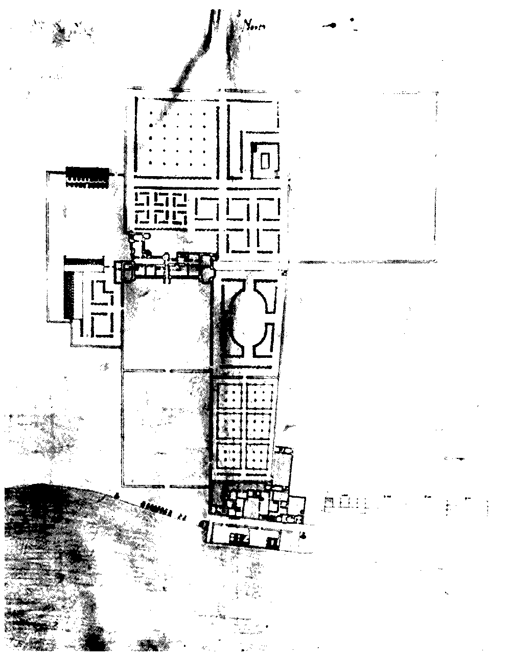
Plan of Sir Robert Cecil's Chelsea Great House and its grounds, c. 1595, stretching north from the Thames
CHELSEA VILLAGE
Chelsea had no more large mansions and famous or aristocratic residents than any other village around London, but their concentration in the village along the riverside emphasized their presence, which was commented on by visitors and topographers. The quiet backwater nature of the village, at a distance from the main highway and effectively at the end of a cul-de-sac for those without a boat, gave Chelsea peaceful qualities which a house by the river in Westminster or by a main highway into London lacked, yet for those who could afford a well-manned barge it was only a short journey by river to Westminster and Whitehall. Although Chelsea's emergence as a popular residence for courtiers did not start with Sir Thomas More and Henry VIII, the Crown's acquisition of More's estate and the manor did put Chelsea among the locations where the Crown could reward courtiers with property and house ministers, and thereby brought Chelsea's name into national history.
The peak for noble residents in Chelsea was the late 16th and early 17th centuries. The occupants of the Tudor manor house, discussed above, were all close to the Crown, and a succession of prominent residents followed the marquesses of Winchester at the mansion on More's estate: Lord and Lady Dacre, the earl of Lincoln, Sir Arthur Gorges, Lionel Cranfield, earl of Middlesex, George duke of Buckingham. Shrewsbury House saw the earl and countess of Devonshire after the earls of Shrewsbury. The use of Chelsea by courtiers as a pleasant and convenient residence near Westminster continued up to the Civil War, but the presence of such influential residents was not without problems. Sir John Lawrence not only had to complain about his pew being taken by Edward Cecil, Viscount Wimbledon, in 1621, but also that several persons of quality holding lands valued at £260 a year had been taken off the Ship Money assessment in 1638 with the result that he, the countess of Devonshire, and Sir John Fearne had had to make up the difference. (fn. 83) Chelsea was also vulnerable to the plague carried by refugees from the City and Westminster, and a draft proclamation of 1630 threatened to punish inhabitants encouraging disease by entertaining strangers. A pest house suggested by the king's physicians in 1631 was not built, though one existed by 1666. Otherwise, the village had a healthy reputation which contributed to its status as a fashionable suburb in the 17th and 18th centuries and it was favoured for convalescence. (fn. 84) More visitors of all ranks came to Chelsea, and from the 17th century there are frequent references to watermen, who carried passengers on the river, and whose poorer members received many bequests. (fn. 85) Most of the principal houses and some brewhouses and other commercial premises on the riverside included private wharves as part of their property. (fn. 86)
Demand for accommodation led to the building of a handful of new mansions or country houses in Chelsea, (fn. 87) though most building effort before the 1680s went into rebuilding and improving existing houses or adding gardens to them. Information on more humble residences is erratic but suggests steady infilling and increase in smaller houses in the village.
Riverside
Chelsea had two principal streets in its main settlement, the highway by the river and Church Lane. Buildings known in the early to mid 16th century included a house called the Rose or Great Rose which stood 'next to the church', probably meaning facing the river on the opposite corner of Church Lane from the church, which was surrounded by property belonging to the manor house. It belonged in 1549 to Thomas Beane, who also owned three other houses, that occupied by Thomas Sander, a butcher's house next door, and a house occupied by John Colman, gardener to Queen Catherine at the Tudor manor house in 1547. (fn. 88) The Great Rose probably stood on the site of the later nos 64-7 Cheyne Walk, and the house or a later building on this site, which included two gardens and a wharf by the river opposite, formed all or part of the building where Richard Fletcher (d. 1596), bishop of London, lived from at least 1592 until his death. It was later occupied by Sir Thomas Baker, and sold by his widow Constance in 1625, possibly to Sir Edward Powell, Bt, whose wife lived there from 1636 to 1651. Powell also bought the house with gardens and stables in Church Lane which adjoined the north side of his mansion in 1646 and incorporated them into his property. Further alterations were made by Sir Edward's nephew, Sir William Powell alias Hinson, Bt, in 1679, and it was possibly then that the mansion was turned into four houses. At some point the westernmost of the four houses was extended across Lombard Street onto the wharf by the riverside, and was known thereafter as Arch House. (fn. 89)
West of Arch House some houses on the north side of the riverside road were probably medieval in origin: the Dog tavern, later renamed the Sun, at no. 68 Cheyne Walk, was with Waterman's Court a freeholding of the manor with rights of common. (fn. 90) To the west the later no. 72 Cheyne Walk was possibly 16th-century, and may have been part of the gatehouse or outbuildings of Danvers House or part of earlier buildings on Butts close, with another house adjoining to east; it apparently had a pre-existing passage on the west side, which had been built over. Before 1892 it had a narrow plastered street front with two storeys and another window in the single gable, which retained the remains of terracotta classical ornament. It is said to have had rights of common, and may have been the property belonging to Thomas Creake in the early 17th century. (fn. 91) By 1595 the westernmost end of the street was also built up on the northern side. (fn. 92)
The riverside road also had private property on the south side, which seems to have consisted in the late 16th century of wharves, surrounded by pales or brick walls, with a few buildings standing on them. In 1624 Sir John Danvers bought 'waste ground' with new buildings on it next to the river, formerly part of the Hungerford estate, which adjoined ground built with houses by the late 16th century. (fn. 93) Some wharves, such as the horseferry place, remained open, but gradually other sites became built up with houses, and eventually the river lay hidden from the street behind the houses and shops on the south side of the road. The western end of the street was called Beaufort Street by 1735; (fn. 94) after the modern Beaufort Street was so-named in the later 18th century, the riverside road was known as Duke Street, and the part between Danvers Street and Church Lane was known as Lombard Street by 1795. (fn. 95)
Church Lane
As part of the main settlement of the village, piecemeal rebuilding took place constantly in Church Lane, leaving little trace of earlier dwellings. On the east side the southern half was part of the grounds of the medieval manor house, belonging to the Lawrence family from 1584. (fn. 96) By 1665 their property consisted of the old manor house with its outbuildings and gardens, three adjoining cottages on the north side of Lordship Yard, and probably eight cottages on the east side of Church Lane. (fn. 97) A partially legible tablet naming Church Lane and the year, later placed on the south wall of a rebuilt no. 9 on the east side, suggests some rebuilding in the street in the 1660s, and nos 11-15 were also built or rebuilt in the 17th century. (fn. 98) The medieval manor house was occupied by the family until at least 1675, and possibly 1685, and it may have been divided and occupied by others as well. (fn. 99) Between the north side of the Lawrence property and the south side of the rectory estate in Church Lane was a house which had been part of Thomas Hungerford's estate in 1566 and had rights of common. (fn. 100) Robert Chare, citizen and fletcher of London, who bought it from Elizabeth Young in 1611, was presented in 1617 for converting the house into four dwellings, (fn. 101) and by 1642 his son John Chare, a London tradesman, had 6 or 7 houses on the site, one of which he occasionally occupied, especially in summer. He leased an acre of glebe behind his houses to give access to the rear and better gardens. By c.1660 his heirs had leased the acre to Thomas Collett, who enclosed three-quarters of it, dug sand, built a wall, and laid gravelled walks in the garden. (fn. 102) Coins of 1610 and an iron plate dated 1652 were recorded at houses on the west side at nos 16 and 18 Church Street. (fn. 103) At the junction of the lane with King's Road, opposite the rectory, William Arnold built four new brick houses beside the former Wrennall's farmhouse, garden and barn before 1676. (fn. 104)
ADDITIONS TO THE VILLAGE AREA
East and west of the village centre, some major houses were built in the 17th century as well as lesser buildings. At the west end of the village, Gorges House was constructed south of the stableyard of Lord Winchester's mansion, probably between 1617 and 1619. On the east side of the mansion's grounds Danvers House was built c. 1624. (fn. 105) Some indication of the development of this area is given by a settlement made by Sir Arthur Gorges in 1622. The properties included 4 houses and gardens, an orchard, a wharf, a lane and commoning rights. Significantly, they also including part of a ruined building, possibly part of the former parsonage, already in the course of redevelopment. This structure was fifty feet long, of five bays with a walled courtyard in front, and bounded by the Thames to the south, a common way to the north, and Gorges's coachhouse to the east. It continued westwards, where a house had recently been built on this part of the structure by William Whitehand. (fn. 106)
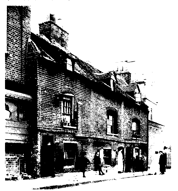
Nos 55-9 (odd) Milman's Street, at the southern end of the east side, probably built in the mid 17th century
In 1646 Sir Arthur Gorges junior with his wife and son leased a brick barn and adjoining ground where a dovehouse formerly stood, enclosed with a brick wall, to William Cox, bricklayer of Chelsea, for 41 years, on condition that Cox spent £50 in converting the barn into dwelling houses. Cox converted the barn into, or built, five houses on the site, claiming he had spent more than £100. Three of the houses were later assigned to Thomas Rosse. (fn. 107) The site seems to have been near Lindsey House and Gorges House, and may account for some of the smaller houses recorded in the Hearth Tax assessments as lying near Lindsey and Gorges houses, some of which belonged to Rosse. These probably included the three brick cottages, of two storeys with dormers in the tiled roofs, which appeared to date from the middle of 17th century, and were later incorporated into the east side of Milman's Street as nos 55-9. (fn. 108) The farmhouse on More estate was apparently rebuilt during the 17th century and later known as Lindsey House: it was occupied by Sir Theodore Mayerne 1639-55, who may have rebuilt it, before alterations or rebuilding by the 3rd Earl of Lindsey. (fn. 109)
At the east end of the village at Chelsea Place, the Tudor manor house, the new owner James, duke of Hamilton, began extensive building soon after acquiring the manor in 1638. He repaired it and extended it by almost doubling the width of the Tudor west range and adding three ranges to form a second courtyard. With the outbreak of the Civil War in 1642 the Hamiltons left Chelsea and the house was later let, probably as two separate dwellings; it was certainly two houses in 1655, divided between Charles Cheyne and Sir Henry Herbert. Cheyne bought the whole manor and sold the freehold of the new part of the house in 1664 to the bishop of Winchester to become Winchester House. (fn. 110)
East of the Tudor manor house and garden the highway left the riverside and led through the fields to Westminster. At the beginning of the 17th century the road ran through the open Eastfield, with meadows by the river, and possibly some closes. In 1606 James I granted part of Eastfield called Thamesshot, lying between the road and the river, as the site for King James's Theological College, laying the foundation stone of the college building himself in 1609. The college was discontinued during the Commonwealth and was empty in 1652, when it was described as a brick and tile building 130 ft from east to west and 33 ft deep: on the ground floor was an entry, kitchen, two butteries, two larders, a hall, and 2 large wainscotted parlours with a closet in each; above were six rooms and 4 closets, and over the whole a very large gallery with a little room at each end and turrets above. It had a yard enclosed by a brick wall at the east end and on part of south side, within which was a kitchen, stable and lofts, again in brick and tile. A walled garden lay on the other part of the south side and the west side. On the north was a yard with walls at the east and west ends, fenced with pales on the north side. The whole site was estimated at one acre. (fn. 111) The building was used for various purposes, including as a prison for Dutch prisoners, until in 1667 the lease was granted to the Royal Society. In 1682 they conveyed it back to the Crown for the Royal Hospital. (fn. 112)
Possibly encouraged by the building of the college, the part of Eastfield west of the college lying between the highway and the Thames also saw some building by the mid 17th century. The Swan Inn and wharf with other buildings had been built on an acre of arable between the highway and the Thames by 1664, and belonged to Francis Smith, maltster, and his son Samuel Smith, citizen and weaver of London. (fn. 113) Samuel Smith was assessed for a property of 7 hearths between the college and Chelsea Place in 1674. (fn. 114) In 1672 John Baker took a lease from Charles Cheyne of two brick messuages lying towards the college, one of them called Sweed Court, and two plots of land, one enclosed with a wall, on which he built premises for glass-making, which continued until c. 1681. (fn. 115) A plot of c.4 a. towards the west end of the highway was leased to the Society of Apothecaries, who built a wall around it in 1674 and three barge-houses by the river, and created their physic garden there. (fn. 116) Daniel Wayte of St Martin-in-the-Fields had a half acre of freehold east of the Apothecaries' garden with a house built on it by the highway before 1684, and was granted a long term of years in another half acre by Charles Cheyne with houses built there. He spent £300 on building a new house on part of the freehold adjoining the Thames. (fn. 117)
Charles Cheyne granted a 31-year lease from 1675 to Richard Robinson of London, clothworker, of ground in Chelsea and all the buildings on it or to be built during the lease, at a peppercorn rent. Robinson built five houses there and obtained an 11-year extension to the lease; at his death in 1687 he was in possession of eight houses and gardens in Chelsea and property elsewhere. (fn. 118) He probably gave his name to Robinson's Lane (now Flood Street) and may have been the builder of the countess of Radnor's house at the corner of the later Paradise Row and Robinson's Lane. (fn. 119) William Cox leased a close nearby, also on the north side of the highway, and built houses there; it was still known as Cox's close in 1862 when it was the site of George Place. (fn. 120)
LITTLE CHELSEA
By the early 17th century a small settlement, called New Chelsea in 1631 but more usually Little Chelsea, had grown up along Fulham Road, with buildings on both the Chelsea and Kensington sides separated by fields from other settlements in the two parishes. The reason for the growth of a settlement here is not known, though two major farms with lands in both parishes had farmhouses here on the Kensington side. (fn. 121) By 1631 some 14 acres in Chelsea's Westfield at the rear of houses in Little Chelsea had been enclosed for gardens. (fn. 122) A house had been built on 5 acres adjoining Fulham Road which were let to Richard Stocke by 1618, (fn. 123) and between 1634 and 1644 Johanna Abell built or rebuilt a mansion and three other houses on the site of two houses and gardens fronting Fulham Road, probably on 5 acres on the west side of Stocke's house. (fn. 124) In 1666 there were 7 houses at Little Chelsea rated for hearth tax under Chelsea, the main one belonging to Sir James Smith with 18 hearths, followed by Dr Baldwin Hamey with 13, two houses with 8, and three others with 6, 4, and 3 hearths respectively. There were two or three more houses by 1674, all of 4 hearths. (fn. 125)
Also enclosed out of Westfield were the gardens attached to the house later known as Stanley House, which stood isolated on the north side of King's Road close to Counter's Creek; its 7 acres of grounds stretched from King's Road to Fulham Road. The house seems to have been that sold to Dudley, Lady Lane, by her mother Lady Elizabeth Gorges by 1630, and extended by Lady Lane, who had taken part of an 11-acre inclosure in Westfield for a garden. (fn. 126) In 1643 Lady Elizabeth Gorges sold the house and grounds to another daughter, Elizabeth Stanley, later the wife of the 4th earl of Lincoln. The house had 11 hearths in 1666. (fn. 127)
CHELSEA BY 1680
In 1674 there were 172 houses in Chelsea chargeable for hearth tax, 8 of which were listed as lying at Little Chelsea; the exempt were not apparently listed. 50 of the houses were marked as empty, including some of the largest: Buckingham's house (formerly Lord Winchester's), with the most hearths at 61, the house thought to be Danvers House with 48, and Chelsea college with 12. (fn. 128)
It is clear that though a few substantial country mansions were built or created in Chelsea in the early 17th century, by the middle of the century the demand for housing in Chelsea was more for substantial or middling town houses rather than for great mansions. In the 1650s the enlarged Tudor manor house was divided into two separate dwellings, occupied as though they were semi-detached mansions, one of which became Winchester House. Shrewsbury House had also become two dwellings by 1674, and by 1695 one part was a school. This was also the use that Gorges House had been put to by 1676, while Danvers House was demolished by 1700. (fn. 129) The owners of the duke of Buckingham's mansion had difficulty in selling it at the Restoration, and when it was up for sale again the 1st duke of Beaufort, who bought it in 1681, had difficulty persuading his wife that such an old house could be given modern comforts. (fn. 130) After the duke and duchess died, it remained largely empty until it was demolished. (fn. 131)