A History of the County of Middlesex: Volume 12, Chelsea. Originally published by Victoria County History, London, 2004.
This free content was digitised by double rekeying. All rights reserved.
'Settlement and building: From 1680 to 1865, Hans Town', in A History of the County of Middlesex: Volume 12, Chelsea, (London, 2004) pp. 47-51. British History Online https://www.british-history.ac.uk/vch/middx/vol12/pp47-51 [accessed 12 May 2024].
"Settlement and building: From 1680 to 1865, Hans Town", in A History of the County of Middlesex: Volume 12, Chelsea, (London, 2004) 47-51. British History Online, accessed May 12, 2024, https://www.british-history.ac.uk/vch/middx/vol12/pp47-51.
"Settlement and building: From 1680 to 1865, Hans Town", A History of the County of Middlesex: Volume 12, Chelsea, (London, 2004). 47-51. British History Online. Web. 12 May 2024, https://www.british-history.ac.uk/vch/middx/vol12/pp47-51.
HANS TOWN
Until the 1770s the large eastern area of the parish stretching from Knightsbridge in the north to King's Road was still fields and market gardens, with few buildings apart one or two along King's Road, and on the small Lowndes estate in the extreme north-east corner of the parish. The Lowndes estate consisted in the 17th century of a close of pasture held in the 1660s under a Crown lease, (fn. 1) and in or soon after 1670 Henry Swindell, the sub-lessee, built a house there with extensive grounds which became a well-known pleasure resort, originally called Spring Gardens. In the 18th century the large building on the site was called Rural Retreat and later Grove House, where Theresa Cornelys, who had once held fashionable balls and masques in Soho Square, as Mrs Smith tried to restore her fortunes by opening a suite of breakfast rooms, a venture which had failed by 1797. Her successor, William Ick or Hicks, had an archery ground at the rear, still there in 1813. (fn. 2) On King's Road a building stood on the north side by 1745, probably in conjunction with the garden ground which lined the road there. (fn. 3)
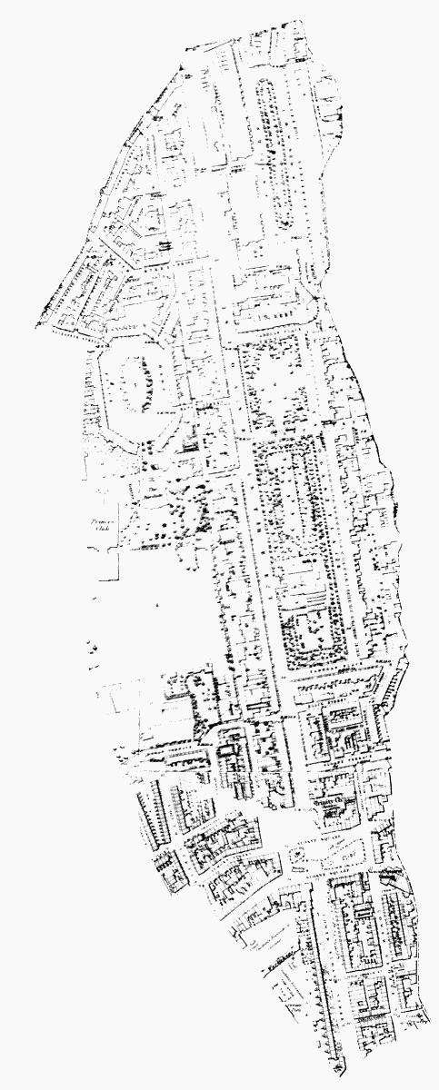
Section of OS 1st edition map showing the Hans Town area, including Hans Place (west), Cadogan Place (east), and Sloane Square (south)
In 1771 Henry Holland the elder, builder, and his son Henry the architect put forward an ambitious scheme for the 89 acres of fields along the eastern boundary of the parish, which then belonged to the heirs of Sir Hans Sloane and was later part of the Cadogan estate, (fn. 4) and an agreement was drawn up between the owners and Henry Holland junior. (fn. 5) Hans Town, as it was originally known, became the model for the many new 'towns' which sprang up around central London. The agreement covered the land from Knightsbridge in the north to the backs of the houses in Turk's Row and White Lion Street in the south, and included a short lane which led from the highway at Knightsbridge into the fields. Building was delayed, however, and in 1776 Holland proposed a building lease for c. 34 a. on which he would spend £15,000 on buildings, with a lease to him for the rest of the land with liberty to build. By late 1777, when this arrangement was confirmed in a new agreement, Holland had already spent a large sum on buildings which were about to be completed along the new north-south street he had laid out running from the old lane at its junction with the highway at Knightsbridge south to King's Road. Holland agreed that before 1784 he would build a uniform street of houses without bow windows or any other projections except door-cases, porticoes, and iron rails, on 23 of the 34 acres, which took in a strip 150 ft deep on both sides of Sloane Street from Knightsbridge approximately to Sloane Terrace. By September 1783 he would build other similar uniform houses on both sides of Sloane Street at the southern end where it met the King's Road, and before 1785 would build similar buildings on each side of the extension of Sloane Street south of the King's Road, in all covering another 10 acres. Sloane Street was to be 80 ft wide, narrowing to 70 ft at the northern end; the street accounted for nearly 8 acres of land. Holland's rent was to start at £367 a year for 4 years, rising in three stages to £705 after 8 years, with an additional £10 an acre if he took any of the remaining 47 acres for building. Neither the street acreages nor the plan in the agreement show Sloane Square laid out nor Hans Place or the other side streets, though the square for Cadogan Place was delineated, so it is unclear whether the street plan for the whole area had in fact been decided by then. (fn. 6)
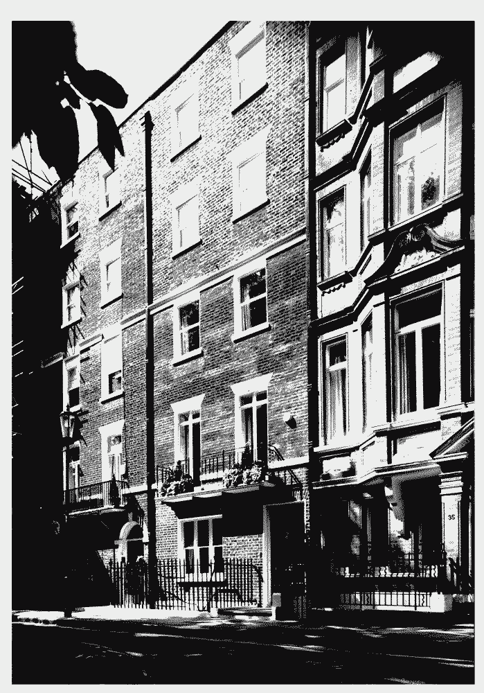
Nos 33-4 Hans Place, surviving examples of the original 18th-century houses, later heightened
Holland intended an estate of moderately-sized houses along Sloane Street, and himself built some of the first groups of houses, of white brick, in Sloane Street. Most sites, however, were taken by others to build on and subleases were granted by Holland for one or two houses as they were completed. Many of those taking plots from Holland included his cousin Richard Holland, his nephew Henry Rowles, and several men who had worked with him elsewhere. In 2003 few of the houses, mostly of stock brick with 2 bays and 2 or 3 storeys with basements and attics, and a variety of doorcases, survived and none unaltered. One group on the west side of Sloane Street at the south end was superior, with houses of 3 bays which had more unusual enriched timber doorcases, none of which apparently survived in 2003. (fn. 7) Leases for houses on the west side of Sloane Street date from 1777 and by 1780 nearly all the plots had been taken, (fn. 8) though the leases followed a few years later. Leases and agreements were granted in 1783 and 1786 for the west side of Sloane Street, (fn. 9) for houses on south side of North Street 1788, (fn. 10) land at the corner of North and Exeter streets in 1790, (fn. 11) the west side of Lower Sloane Street in 1790, (fn. 12) and George Street in 1792. (fn. 13) Sloane Square was laid out where Sloane Street crossed the king's private road, and was largely occupied by 1780. Lesser streets were laid out on the west side of the street, and some leases for houses in the mews behind Sloane Street (now Pavilion Road) date from 1788.
The most unusual feature of the scheme was Hans Place, a rectangle with the corners cut off, entered by streets on north-west, north-east and east, and with a wide opening on the south. It was laid out by Holland on part of the 47 acres he held in reserve, and he took 3 acres to the south of it to build for himself a house, framed by the southern opening of Hans Place, which he occupied by 1789; it was initially called Sloane Place but later the Pavilion, a reference to Holland's work for the Prince of Wales at Brighton. The entrance to the house was on the north side and two narrow wings, which housed coachhouse, stable, and drawing office on the east, and laundry, dairy, and scullery on the west, extended northwards enclosing a courtyard. When it was built the house was approached by a short avenue from Sloane Street on the east, with a covered entrance to the courtyard through the ground floor of the wing. A dung-heap was shown on the plan of 1790 at the northern boundary of the site near the west wing, (fn. 14) which suggests that the later approach and entrance from Hans Place, which existed by 1794, (fn. 15) had not then been planned.
On the south side the simple, 5-bayed villa, faced in timber tiles, had an iron-railed balcony running the length of the house above a loggia, looking out over 3 acres of gardens. The kitchen garden on the west had hothouses, a vinery, and walls lined with fruit trees. Beyond the immediate grounds was a meadow of 16 acres, which was laid out with a small lake between 1813 and the 1830s. (fn. 16) In 1829 it had a Gothic ice-house on the west side of a lawn and ruins of an ancient 'priory' with shrubberies and walks, and a courtyard had been formed on the west side of the priory ruins with a gateway leading to a private carriage-road to the west which ran into the green lane (Green Lettuce Lane) connecting with Blacklands Lane. (fn. 17) A square was planned to lie south of the park, but this was not built. (fn. 18)
| Hans Town in 1795 (fn. 24) | ||
| Location | No of Properties (mainly houses) | Including: |
| Great Sloane St (W side) | c. 134 | stables, school, workshop, pub. ho., coachhos. |
| Great Sloane St (E side) | 16 | plus land |
| Sloane Terrace | 5 | |
| Sloane Square | 55 | sheds, bakehouse, workshop |
| Great George Street | 16 | stables and warehouse, shop, 2 lodging-houses |
| Union Street (by par. boundary) | 3 | plus row of 22 properties by the brook with a slaughter ho. |
| Little George St | 10 | a lodging-house |
| Lower Sloane St E | 33 | plus vacant land |
| Chelsea Market | 18 | |
| Lower Sloane St W | 46 | |
| King's Rd in Hans Town | 8 | 2 gardens and cottage |
| New Road (Pavilion Road) | 44 | 6 coachhouses and stables, workshop |
| Wonder What Place | 12 | hos rated very low at £5 |
| Exeter Street | 19 | 4 coachhouses and stables |
| Exeter Place | 10 | |
| New Street | 3 | 1 coachhouse and stables |
| North Street | 57 | 2 shops, 4 coachhouses or stables, 1 warehouse, 1 milkhouse |
| Elizabeth Street | 12 | |
| York Street | 11 | |
| Hans Place | 42 | 10 unlet or unfinished. Henry Holland rated at £188. |
Except for a few houses at the north end there was no development on the east side of Sloane Street before 1790. Holland had initially planned an Anglican chapel to face the approach to his house, but though he had the support of the rector of Chelsea, opposition came in 1791 from the chaplains of three existing chapels outside the parish at Ebury, Brompton, and Knightsbridge, who feared diminished congregations. Holland stated that 340 houses had already been built with a population of c. 1500, making a chapel necessary, and he had the support of the bishop of London, but the plan was dropped; (fn. 19) it took some 40 years until Holy Trinity church was opened at the southern end of Sloane Street. (fn. 20) Also in 1791 the decision was made to lay out unbuilt land on the east side of Sloane Street in a long narrow garden divided by Pont Street, with terraces of houses on the north, east, and south, many of which survive on the east side. At the north side lay Upper Cadogan Place with 12 houses plus another larger one with a garden at the east corner. By 1804 this terrace and nine similar houses on the east side had been completed, with six more south of Pont Street. In 1804 Holland leased to Henry Rowles the garden ground and other premises on the east side of Sloane Street, to be called Cadogan Place, for 80 years, and three months later Rowles made an agreement with the Hans Town Commissioners to enclose the ground in the centre of Cadogan Place with an iron railing and not to build there for the duration of his lease. (fn. 21) The gardens in the two halves of Cadogan Place were laid out separately, the northern part to a design by Repton, the larger southern part in 1807, occupied by Salisbury's Botanic Garden, which had moved from Lambeth Marsh. (fn. 22) Leases were granted from 1791 for Ellis and D'Oyley streets, south of Cadogan Place, and Sloane Terrace and Charles and Earl streets were built at about the same time. (fn. 23) Plots south of Sloane Square had also been laid out by 1791 as far as Turk's Row.
The properties rated in Hans Town in 1795, summarized in the table above, show the mixed nature of the Hans Town development. Premises in many of the streets, for example those north of Hans Place and north-east of Sloane Square, were utilitarian in character: stables to serve the larger houses, and workshops and modest houses for local tradesmen. The social mix of the area was further emphasized by the opening of a Methodist chapel in Sloane Terrace and an Independent one in Pavilion Road, both in 1811. (fn. 25)
The land in Holland's 1777 agreement formed the district of Hans Town, for which an Act was obtained in 1790 for the creation and repair of the public streets and passages with powers to light, clean, repair and pave, and to appoint watchmen, with commissioners given powers to raise rates for the purpose. Thereafter the residents of Hans Town were excluded from the rating for highways in the rest of Chelsea on payment of a total of £4 a year to the vestry. The powers of the commissioners in respect of cleaning and repairing of streets were enlarged by an additional Act in 1803. (fn. 26)
Following the creation of Sloane Street, some terraced houses were built along the west side of Spring Gardens, and by 1810 Henry Rhodes, surveyor to the Lowndes estate, was making plans to exploit the property in conjunction with the adjoining Grosvenor estate in Belgravia (Westm.). An Act was obtained in 1813 to allow parts of the Lowndes estate to be sold or let on long leases, but only in 1819 did the process begin with a joint application by the two estates for permission to lay drains. In 1823 shops, houses, and the floorcloth factory, which lay just outside Chelsea's boundary, were demolished, (fn. 27) but Lowndes Terrace fronting Knightsbridge, on the part of the estate lying in St Margaret Westminster, and openings out of the south side of Knightsbridge road which became William Street and Charles (later Seville) Street were the only development carried out before Thomas Cubitt took over the work in 1826. (fn. 28) He received approval for William Street in 1827, (fn. 29) but most of his work there took place in the 1830s and 1840s when he finally built up much of Lowndes Square and the rest of the estate in Westminster. (fn. 30)
The link with Knightsbridge made Hans Town part of the metropolis rather than part of Chelsea village, but it also brought less desirable problems with the proximity to the capital's barracks. In 1824 three Life Guards who had been drinking and playing skittles at the Bedford Arms in Pont Street wrecked the public house and then attacked the watch sent to stop them; a posse of 15 watchmen and the two Hans Town constables were unable to apprehend them, and they had to get men from Knightsbridge barracks to assist them. (fn. 31) The creation of Hans Town district reinforced the separateness, and the Cadogan Estate managed and developed the area in a similar way and with similar objectives to other West End landowners such as the neighbouring Grosvenor Estate. Hans Town also increased the desire of local property owners for the creation of the embankment, which would open up the rest of Chelsea and hopefully lead to a similar demand for high-class residential use.