A History of the County of Middlesex: Volume 12, Chelsea. Originally published by Victoria County History, London, 2004.
This free content was digitised by double rekeying. All rights reserved.
'Settlement and building: From 1865 to 1900', in A History of the County of Middlesex: Volume 12, Chelsea, (London, 2004) pp. 66-78. British History Online https://www.british-history.ac.uk/vch/middx/vol12/pp66-78 [accessed 25 April 2024]
In this section
FROM 1865 TO 1900
This section covers building in the whole parish from 1865 to the end of the century, covering improvements made by private landlords who built up Cremorne and World's End, by local authorities, and by philanthropic bodies, and the effect of the embankment and new building near the river, as well as the redevelopment of Hans Town and nearby open spaces. Between 1865 and the start of the 20th century nearly all of the remaining undeveloped land was covered by building, and some areas were rebuilt by private landlords, principally the Cadogan Estate.
PRIVATE DEVELOPMENT
CREMORNE AND WORLD'S END
The largest area of land in Chelsea still unbuilt in 1865 formed most of the south-western corner of the parish, bounded by King's Road on the north, Chelsea Creek and the Thames on the west and south, and Blantyre Street on the east. The lessee of Cremorne Gardens, T.B. Simpson, (fn. 1) bought the freehold of the whole area stretching from Hob, or Cremorne, Lane to Chelsea Creek, except for the part of Lots meadow sold by the parish to the Kensington Canal Company c. 1828. (fn. 2) He presumably bought the land with a view to building, which had already started by 1866 with three terraces of houses on the south side of Lots Road, with access left to the land behind stretching to the river. (fn. 3) By his death in 1872 Simpson had built 18 houses at a cost of £18,000, and paid £1,000 for embanking Poole's Lane, £2,000 for embanking the Cremorne frontage, £3,150 for sewers, £500 to the Thames Conservancy for the privilege of embanking, and another £1,500 for erecting two piers. (fn. 4) In 1876 his widow Jane sold land between Lots Road and the Thames to John Bennett Lee and George Hervey Chapman, London timber merchants, on which Cremorne wharf was built, (fn. 5) and part was sold to the vestry for a pumping station the following year. (fn. 6)
In 1870 the area between Poole's Lane and the canal comprised the large site (c. 1 a.) at the north end by King's Road with buildings north and south of an open yard, let to Thomas Ferguson and including a house, mill, and iron foundry; the flour mill and stable let to James Edward Christie; a stone wharf, stable, and dwellings let to William Christie; and south of that an acre of open land described as 'wharves' and occupied by Simpson himself. One acre of land had been taken for new roads (Poole's Lane and Lots Road). (fn. 7) William Christie was among those involved in building new houses, taking a lease in 1869 for a newly-built house on the east side of Poole's Lane, one of at least six built on the south side of the junction with a new road. (fn. 8) In 1871 the MBW was considering applications to form new roads on the Ashburnham Estate, (fn. 9) and presumably the street plan for all Simpson's land was drawn up by the early 1870s. (fn. 10) Cremorne Road was extended from Cheyne Walk north-westwards to King's Road; the other streets ran north-south or east-west. The vestry stopped up Hob Lane and replaced it with a new street, Dartrey Road, a little to the west, completed in 1879. (fn. 11) Cremorne Gardens finally closed in 1877 when the site was required for building. (fn. 12)
By 1894 almost the entire area between Dartrey Road and the former Poole's Lane was built over with streets of small terraced houses, many having only small yards at the rear, and south and west of Lots Road adjoining the canal and the Thames were a string of wharves and other industrial and commercial premises. Much of the building was carried out in small lots and most of the known building leases were granted in the 1880s. (fn. 13) After open-air services, St John's CE iron church was built in 1873 at the apex of a triangular site between Tadema and Ashburnham roads, and the incumbent also started a mission church at the junction of Dartrey Road and Blantyre Street in 1880. (fn. 14) The Ashburnham board school opened in Upcerne Road in 1885. (fn. 15) In the 1890s the Ashburnham Park Nursery still fronted King's Road between Ashburnham Road and Edith Grove but was largely built with glasshouses: Wimsett & Company occupied the northern half, Bull & Son the southern. (fn. 16)
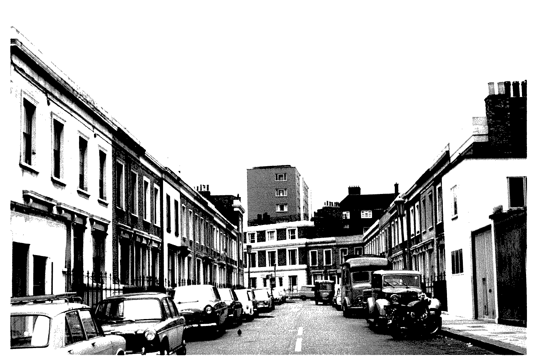
East of Dartrey Road the land belonging to George Norris was being built over in the 1860s to create Blantyre, Luna, and Seaton streets: most of Blantyre had been laid out by 1865 with 2- and 3-storeyed houses with area basements, and 3-storeyed houses with basements were built in Seaton (fn. 17) under leases granted in 1866-7, and in Luna Street under leases of 1868. (fn. 18) In 1870 the MBW renumbered World's End Passage, incorporating Heathfield Terrace, Cremorne Terrace, and Davis's Place in the numbering. (fn. 19)
On the west side of Milman's Street George Stephenson built Strewan Terrace in 1875, which included the corner house by the entrance to his builder's yard on part of the land, (fn. 20) and by 1878 Strewan Square had also been laid out behind with an entrance between nos 10 and 11 Strewan Terrace. (fn. 21) On the east side of Milman's Street, building had been extended northwards to cover the nursery ground at the north-east corner with a terrace of houses and shops fronting Milman's Street and King's Road by 1894. (fn. 22) In Ann Place off the east side of Milman's Street, casual wards were built in 1893 with a small frontage onto Milman's Street. (fn. 23)
Blantyre Street looking north from Cheyne Walk, showing houses of the early 1860s
CHELSEA RIVERSIDE
The development around Cremorne followed a traditional pattern for mid Victorian London suburbs, but elsewhere in Chelsea the year 1874 marked the introduction of two new developments which changed Chelsea radically, both in its appearance and in its social structure: Chelsea Embankment, and the Hans Town improvements.
Before 1874 Chelsea's riverside was a collection of commercial wharves, public stairs, and various small houses and other premises. (fn. 24) The embankment constructed in Westminster in the 1850s stopped at the Royal Hospital, but after much campaigning it was extended westwards to Battersea Bridge in the 1870s. (fn. 25) Despite widespread support for the embankment, however, not all the changes it involved were welcomed. Although the inhabitants of Chelsea had often been hostile to the dirty conditions and other problems created by the wharves, they were reluctant to see the Cheyne Walk public draw dock closed, (fn. 26) but the MBW refused to provide a replacement behind the embanked roadway. (fn. 27) The parish then solicited a wharf west of Battersea Bridge, (fn. 28) and the matter was resolved by the vestry's acquisition of premises at the junction of Chelsea Creek with the Thames in 1876-7. (fn. 29) By 1894 the wharves built along the western end of Chelsea's riverside and along Chelsea Creek included Chelsea vestry wharf just east of the creek's mouth, and Kensington vestry wharf just west of Cheyne Walk; Lindsey wharf, west of Battersea Bridge, was an older wharf which survived construction of the embankment. (fn. 30)
The Impact of the Embankment
The creation of the embankment made a radical change to Chelsea, and especially to its picturesque riverside. As the vestry and improvement commissioners had hoped, it raised property values, or at least encouraged rebuilding or modernizing of older properties to provide the substantial middle-class houses that would bring in more affluent residents. In this period the more affluent wanted spacious modern houses which fronted major roads not side streets, and the embankment which replaced the old riverside road was a more appropriate setting for those houses. The old houses and wharves on the south side of Duke and Lombard streets abutting the river were swept away, land was reclaimed from the river to create Chelsea Embankment, and between the old church and the east end of Cheyne Walk strips of garden were laid out between the houses in Cheyne Walk and the roadway to provide some barrier from the increasing traffic there. Some small 18th-century houses formerly on the north side of Lombard Street and used as shops remained as Lombard Terrace between Danvers and Church streets, but by the 1890s the site at the eastern corner of Beaufort Street, built over since at least the late 16th century, had also been cleared between Beaufort and Danvers streets and rebuilt. Albert Bridge was built in 1873, displacing the Cadogan pier eastwards, and with the earlier Battersea (1771) and Chelsea (1858) bridges linked Chelsea more firmly with London on the south bank.
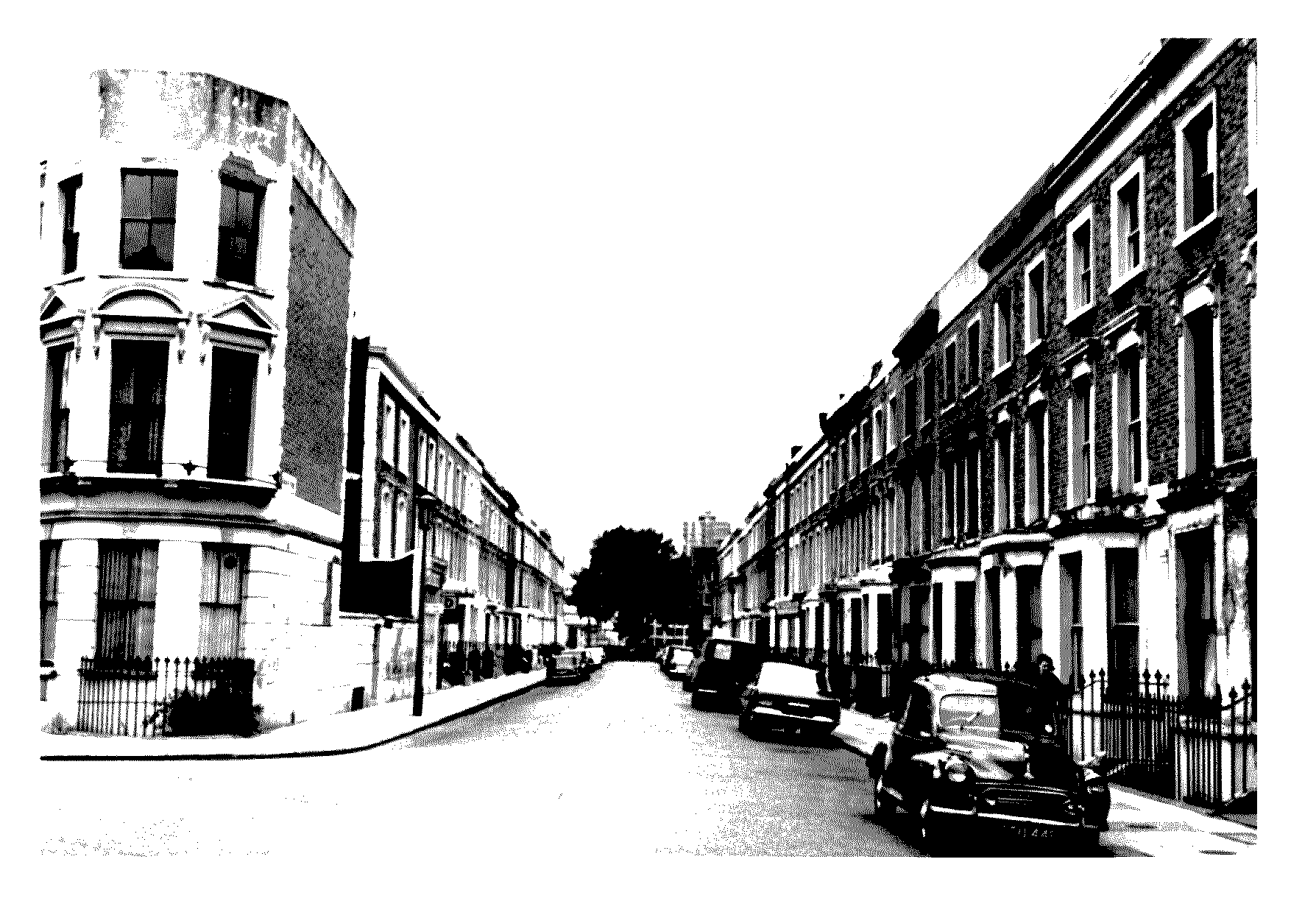
Seaton Street looking south, with houses of the late 1860s
The desire to take advantage of an improved market after the creation of the embankment led to piecemeal rebuilding and improvement of older houses near the river, especially on the Cadogan Estate. In Cheyne Walk, no. 2 was refronted in 1879 from designs by S.B. Clark, (fn. 31) no. 1, at the corner of Flood Street, was rebuilt in 1887-8 from designs of Frederick Hemings, (fn. 32) and nos 7-12, were also rebuilt during the 1880s in Queen Anne style. Hemings also designed 4-storeyed mansion flats in or near Cheyne Walk in 1888. (fn. 33) The extended gardens behind the Cheyne Walk houses were replaced by Cheyne Gardens on the west side of Manor Street, a terraced row set back behind a strip of trees, and at about the same time the houses on the opposite side of Manor Street were rebuilt in a similar style and also renamed Cheyne Gardens. Near the old church the 6-storeyed Carlyle Mansions (1886 by W. Seckham Witherington) (fn. 34) and the Children's hospital (1888) were built either side of Lawrence Street, the latter replacing nos 59-61 Cheyne Walk. (fn. 35)
From the late 1870s most new buildings in Chelsea, like Cheyne Gardens, were built in the red brick and terracotta which were the preferred materials of the new Queen Anne style and for which the eastern part of Chelsea became famous. The new embankment led to an influx of the style, when sites for building on Chelsea Embankment between the eastern end of Cheyne Walk and the Royal Hospital, and in the newly-created Tite Street, were made available by the MBW from 1877. The houses on Chelsea Embankment were almost all built in the late 1870s, a collection of 18 individualistic and grand red-brick town houses in Queen Anne style, some of the first to break with the stucco of Belgravia and Kensington, and designed by some of the leading proponents of the style. The sites facing the river, large enough for substantial mansions, were quickly taken and architects engaged to work in the new style, mainly for 'rich people with artistic inclinations': (fn. 36) Richard Norman Shaw designed no. 8 (Clock House) 1878-80, nos 9-11 in 1878-9, no. 15 (Delahay, formerly Farnley, House) 1878-9, no. 17 (Swan House) 1875-7, and no. 18 (Cheyne House) 1875-7. E.W. Godwin designed nos 4-6 in 1877-8; Bodley & Garner, no. 3 (River House) 1876; I'Anson, no. 13 (Garden Corner) c. 1878-80, refurbished inside by C.F.A. Voysey in 1906; R. Phené Spiers, no. 7 in 1878-9. (fn. 37)
The southern end of the gardens of Gordon House, part of land belonging to Chelsea Hospital, was taken for building in 1897. The score or two of lofty red-brick houses in Embankment Gardens and flats called Chelsea Court, designed by Delissa Joseph, dwarfed the Hospital, and aroused public fears that the government intended to build over the Hospital's grounds. Joseph had to respond that though the triangular site belonged to the Hospital, it had never been part of the grounds, and had been vacant since the site of the naval exhibition was held there in 1891. (fn. 38)
Changes Behind the River Frontage
By 1900 changes had also spread to areas behind the river frontage, with infilling on vacant sites and replacement of older houses with blocks of flats. Kings Mansions was built in Lawrence Street by 1894 and Tennyson Mansions nearby soon afterwards. The house and pottery occupied by William de Morgan from 1876 to 1882, at no. 36 Cheyne Row (Orange House) at the northern end, was demolished and replaced in 1894 by the Holy Redeemer RC church. (fn. 39) Mansion flats called Carlyle Gardens were built on the west side at the corner of Lordship Place by 1902. Several ranges of mansion flats were also built between St Loo Avenue and the houses in Cheyne Walk, with St Loo Court on the north side and Rossetti Mansions on the south side of St Loo Avenue, both with frontages onto Flood Street, (fn. 40) and Rossetti Studios were built in 1894 further north in Flood Street. (fn. 41)
Building on the glebe estate continued from 1867 with leases granted for houses on the west side of Oakley Street (1867-8), houses and shops on the south side of King's Road and in Cook's Ground (1868-9), and 12 houses on the west side of Cook's Ground (1869-70), where a solid row of houses was built on the west side of the northern arm of the street; on the east side groups of larger houses with some open space, including Glebe Studios were built 1888-9. (fn. 42) Leases were granted 1868-9 for the east and west sides of Caledonian Terrace running north from Cook's Ground, and the 8 houses on each side of the road were extended northwards by another six on each side by 1878; by 1894 it was extended to join King's Road and renamed Bramerton Street. (fn. 43) By 1870 almost all the glebe had been leased and was in the process of being built over. The rectory stood in a heavily populated area and nearly surrounded by buildings; its grounds fronting King's Road were considered highly convenient for building, and an Act was obtained to allow the land to be leased for that purpose. (fn. 44)
The embankment also influenced new building north of Royal Hospital Road, in particular on the Cadogan Estate. In the 1870s the last of the nursery gardens in this area of Chelsea together with a detached mansion called Manor House in Smith Street and its grounds stretching westwards to Queen (later Flood) Street was laid out with Tedworth Square and Redesdale and Redburn streets; nos 38-50 Tedworth Square were built by Edward Wright under an agreement of 1876. (fn. 45) Lord Cadogan extended the line of Tite Street north of Royal Hospital road and leased land on the east side to Henry John Wright, builder, in 1883, who had built no. 25, (fn. 46) and made further attempts to upgrade existing parts of the estate, in 1886 agreeing to provide land to widen Flood Street and Queen's Road West (later Royal Hospital Road) if he was allowed to stop up George Place, a narrow cul-de-sac which ran northwards from Queen's Road close to the junction. (fn. 47)
HANS TOWN AND LENNOX GARDENS
The Queen Anne Style
Rebuilding in the Queen Anne style took place piecemeal over most of the Cadogan Estate after 1874, but in Hans Town the Estate engaged in wholesale rebuilding as well as developing the remaining open land, seeking a style and type of building which united the Hans Town area with the upper middle-class areas to the east, while much of the rest of Chelsea was to remain for some decades a fairly poor backwater of lower middle-class housing. The red-brick and terracotta Queen Anne was radically different from the existing stock brick and stucco in neo-classical or Italianate style that existed in Hans Town and neighbouring Belgravia. (fn. 48) Its use for individual houses had already started on Chelsea Embankment, but in Hans Town the style was used in a new form for mainly speculative building.
The Queen Anne style seemed to be an appropriate response to a demand for a new urban style. The version developed here, with forms and motifs borrowed from 17th-century Flemish town houses, emphasized the individuality of each house, stressed vertical rather than horizontal lines, and replaced 'the hated sham of stucco with the honesty of brick'. In planning, too, the new development broke new ground: houses had deep and ingenious plans, and on the south side of Cadogan Square J.J. Stevenson adopted almost standard plans with varied frontages, a novel idea for speculative development. (fn. 49) By adopting the new style the Cadogan Estate placed itself in the forefront of advanced taste, and no London estate in the later 19th century, except possibly Grosvenor, enjoyed a more favourable treatment by the architectural press. The new development, with a garden square named after the freeholder, was laid out along the usual lines, enforcing conformity with all houses faced with red brick, mainly enlivened by moulded brick and terracotta. (fn. 50) This startlingly different style eventually eliminated the use of the once ubiquitous Italianate, and its description by Sir Osbert Lancaster as 'Pont Street Dutch' made its association with the rebuilt Cadogan Estate even stronger. (fn. 51)
Pont Street, Cadogan Square, and Lennox Gardens
Between Marlborough Road (later Draycott Avenue) and the eastern boundary of the parish, only Prince's cricket ground, belonging to the Smith's Charity Estate, and the grounds and paddock of the Pavilion, belonging to the Cadogan Estate, remained open land in 1865. In 1874 the Cadogan and Hans Place Improvements Act was passed, (fn. 52) which enabled the newly-formed Cadogan and Hans Place Estate Ltd, which carried out the development on the two estates, to extend Pont Street through the unbuilt area west of Sloane Street to Walton Street and to build other new streets. The chairman of the company, Col. W.T. Makins, already had some connection with John James Stevenson, one of the leading innovators in the Queen Anne movement, and its use for the company's buildings probably derived from Makins' taste. (fn. 53) The extended Pont Street ran west passing close to the southern end of Hans Place, and turned to meet Walton Street at right angles. South of the street, Henry Holland's Pavilion was demolished and Cadogan Square and adjacent streets were built over the site and the field behind on the Cadogan Estate, while Lennox Gardens, Lennox Gardens Mews, and Clabon Mews were laid out on the former cricket field belonging to Smith's. Building was under way in Pont Street in the late 1870s; (fn. 54) the houses built were mainly held on 99-year leases from 1874. The Cadogan and Hans Place Company by 1881 was responsible to Smith's for ground rents on eight houses at the west end of the new Pont Street, with part of Pont Street Mews behind. For this ground J.J. Stevenson designed nos 42-58 Pont Street, with angular bays and balconies supported on curving consoles, 1876-8, but building continued into the mid 1880s. No. 67 (Farm House) was built in 1884 for Sir Herbert Stewart to designs by C. W. Stephens, a red brick structure with tile-hanging to the upper storey and half-timbering in the gables. (fn. 55)
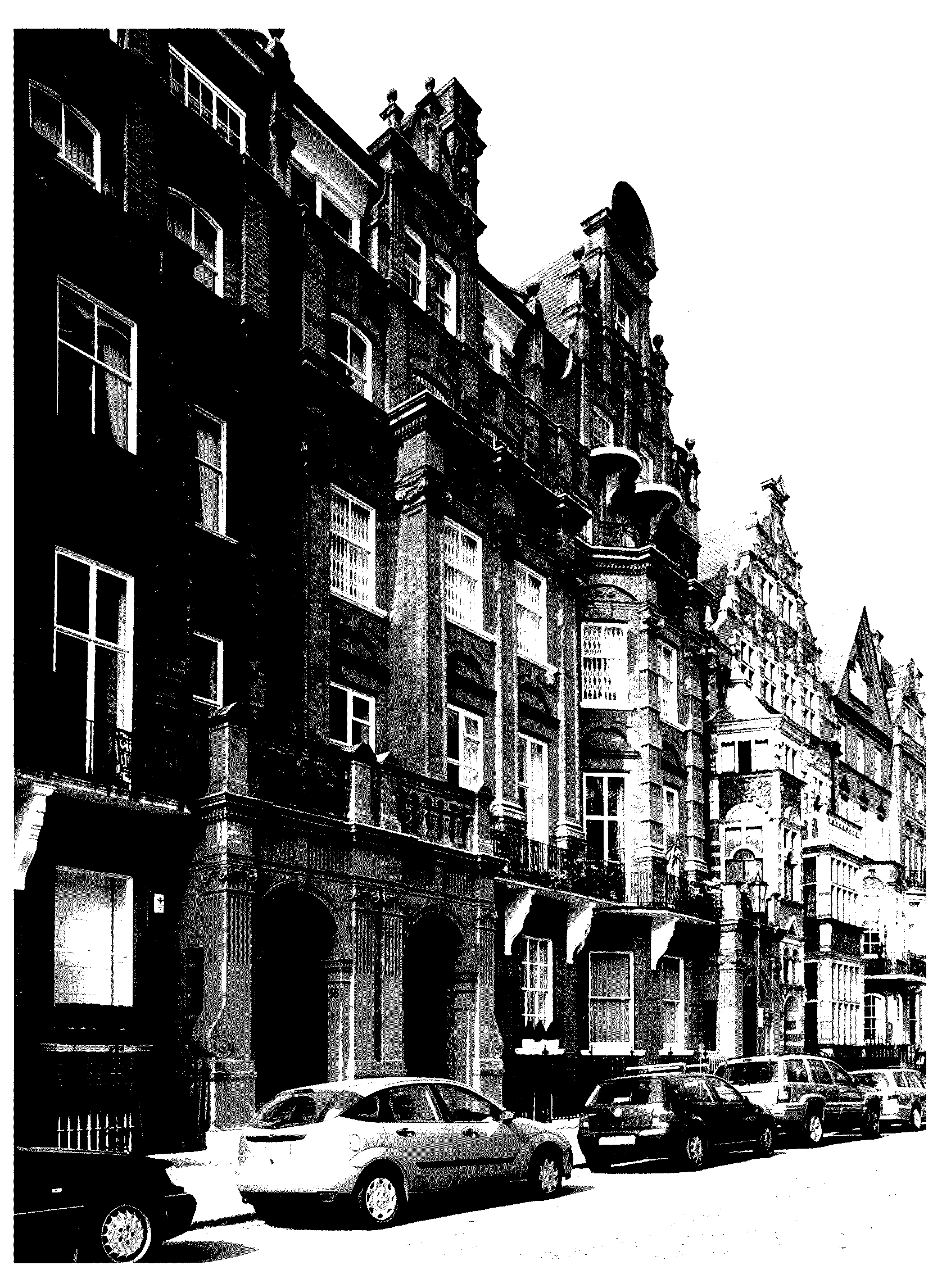
No. 56 Cadogan Square (west side)
Cadogan Square was built between 1877 and 1888. The west side, of 1877-84, had the greatest variety of houses, all variations on the same Flemish-influenced theme; nos 54-8 were designed by William Young in 1877 for Lord Cadogan, and Stevenson was largely responsible for the south side, built 1879-85. The east side was built 1879 by G.T. Robinson, with no. 61 an early example of high-class mansion flats, and no. 61a a studio-house for F.W. Lawson. (fn. 56)
The 54 houses in Lennox Gardens were under construction in 1882 and completed by 1886; in the centre just over an acre was laid out as a shrub and ornamental garden accessible to the householders. Lennox Gardens Mews, laid out on the west side of Lennox Gardens and running past St Saviour's school, which remained, and Clabon Mews were built in same period. (fn. 57) In 1882 the Smith's estate trustees granted a 99-year lease from 1874 of a plot in Pont Street near Walton Street for the Scottish Established Church; work began in 1883 on the new church, on the site which included some land from the Cadogan and Hans Place company. (fn. 58)
In 1890 the Cadogan and Hans Place Estate company was wound up, having built the streets and greatly improved the values on the estates; the capital was returned to the shareholders. (fn. 59) Successor companies were subsequently formed to carry out later phases of development. (fn. 60)
Southern Hans Town
The new streets laid across previously open ground caused only aesthetic alarm; the demolition of streets at the southern end of Hans Town caused social strife, as the Cadogan Estate decided in the 1880s to extend their successful Pont Street revolution into areas heavily populated by small shops and lower middle- and working-class inhabitants.
Lord Cadogan and the Chelsea vestry agreed in 1886 to reorganize the roads south of Sloane Square: Lower Sloane Street was widened, while Little George Street, Chelsea Market, Evans Cottages, Viner Place, George Place, and Woods Buildings, all east of Lower Sloane Street, were closed; Lower George Street was also closed and its upper end was replaced by the wider Sloane Gardens, linking into Lower Sloane Street. The straight Holbein Place replaced The Ditch, which had curved along the line of the Westbourne, and was linked to Lower Sloane Street by Holbein Mews. (fn. 61) All the houses in this area between Sloane Square and Pimlico Road were demolished, and the block formed by Holbein Place and Mews, Pimlico Road, and Lower Sloane Street was reserved for industrial dwellings in 1888, (fn. 62) presumably to rehouse some of the displaced working-class inhabitants.
The work of rebuilding was carried out by William Willett under an agreement made with Lord Cadogan in 1887. (fn. 63) He began in 1888 by forming the new roads and widening existing roads; he agreed with the vestry to pave on the south of side Sloane Square, east side of Lower Sloane Street, and west side of Lower George Street (Sloane Gardens). (fn. 64) By 1894 the area on the south side of Sloane Square was occupied by shops and flats and Willett had built substantial houses on the west side of Lower Sloane Street and both sides of Sloane Gardens. The two large blocks of working-class flats called Holbein Buildings had also been built behind the Baptist chapel of 1865 and the old, narrow 4-storeyed shops and houses fronting Lower Sloane Street and Pimlico Road, which had not been demolished. (fn. 65) Willett, who was also extensively concerned with development of the Holland estates in Kensington, opened one of his two principal estate offices in Sloane Square. (fn. 66)
Willett was also involved in improvements at the southern end of Marlborough Road, where Lord Cadogan had offered to improve some streets running between King's Road and Cadogan Street, if he was permitted to stop up some of the narrow cul-de-sacs north of King's Road near Blacklands House. (fn. 67) In 1890 the Cadogan Estate bought out the Blacklands lunatic asylum and gave one acre of Blacklands and Whitelands to the Guinness Trust for working-class housing. (fn. 68) Willett bought land nearby at the west end of Draycott Place including Blacklands and Whitelands from the Cadogan Estate, and built new houses there under leases dating from 1898-1900. (fn. 69) The part of the estate to the east was rebuilt under an agreement made between Cadogan and J.J. Wright in 1887, covering the area between Cadogan Terrace and King's Road, either side of Leete Street (renamed Cadogan Gardens) and including the east end of Draycott Place. (fn. 70)
Demolitions for higher-class modern houses involved sweeping away not only picturesque architecture and old memories, but also a large body of working-class inhabitants. In 1886 an open-air 'indignation meeting' was organized by working people to protest against Lord Cadogan's 'inhuman policy in breaking up workmen's homes to fill his own pockets', which would seriously affect them. Over 4,000 would be displaced by Cadogan's demolitions of cottage property, while the new model artisans' dwellings, separated from the better class by a mews, would only house 400. The displacement not only affected the residents but also the shop keepers and tradesmen whose businesses depended on them. Evidence given to the Select Committee on Town Holdings in 1887 specifically criticized the fact that the Cadogan Estate's improvements schemes were called philanthropic, when instead of replacing working-class property with better houses for the working class, it was demolished to make room for residential property of a higher class. (fn. 71)
The north side of Sloane Square was also partially rebuilt soon afterwards. A building agreement was made in 1897 between Lord Cadogan and George Edward Wade to rebuild on the sites of no. 7 and parts of 6 and 8 Sloane Square, on the north side stretching back to Holy Trinity church and close to the junction with Upper George Street. Wade was to demolish the existing buildings, and by the end of the year build a house with a shop below, of grey stock brick with red brick on the frontage and Portland stone or terracotta dressings, in accordance with plans and elevations to be approved by Lord Cadogan or his surveyor; he would receive an 85-year lease running from 1895. (fn. 72) Wade had not finished the building nor received his lease by 1900, when he assigned his right to the lease to George Bernard and Amos Ballard, who built the Royal Court Hotel on that northern block of Sloane Square. (fn. 73)
The old-fashioned houses at the south-east corner of Sloane Square were replaced by a large block of shops and flats called Wellesley House, completed in 1906, and the houses adjoining the Royal Court Theatre on the east side were also replaced during the early years of the 20th century; only the west side retained the original houses of Sloane Square. (fn. 74) The original leases for the side streets east of Sloane Street between Cadogan Place and Sloane Square expired in 1887 and the Cadogan Estate then issued several short-term leases for houses in D'Oyley, Ellis and adjoining streets, possibly with future redevelopment in mind, (fn. 75) for which negotiations were underway in 1890. (fn. 76) The large mansion on the north side of Cadogan Place at the junction with Lowndes Street, no. 13 Cadogan Place, later no. 28 Lowndes Street, was acquired by Lord Cadogan in 1850 as his London residence and known as Chelsea House. In 1874 it was demolished and a new Chelsea House designed by William Young was built on the site, a ponderously eclectic stone-built house of 4 storeys with basement and attics, whose 21 rooms included a white marble hall and a large dining room on the ground floor, and an L-shaped drawing room cum ballroom on the first floor. It remained the Cadogans' London house until 1915, and was demolished in the 1930s. (fn. 77)
Though the social consequences of the estate's rebuilding policy engendered criticism, the aesthetic ones were on the whole greeted with pleasure and emulation: landlords of adjacent estates encouraged the new style, which spread through Chelsea and Kensington like a fiery rash, and was seen as a triumph of individualism. Some aesthetic criticism did emerge, however: crowded together the rows of tall red brick houses in Cadogan Square and Lennox Gardens ruined the effect of the architectural detail; there was too much 'cleverness' in picturesque planning, and too much confused variety of detail, far more than would ever have appeared in a genuine Queen Anne town (or country) house. There was also a fundamental incompatibility between the individualistic Queen Anne style and the traditional layout of the homogeneous urban square or terrace.
Whatever the aesthetic or social merits of the policy, it enhanced the residential character and social prestige of the estate. (fn. 78) The rebuilding and improvements which took place in eastern Chelsea in the last two decades of the 19th century were responsible for creating a handsome quarter of London out of what some observers had considered quite an unattractive place: Cadogan Square and Pont Street were constructed on a formerly 'poor neighbourhood', while Sloane Gardens had replaced the 'dismal rows' of 4-storeyed houses which had lined both sides of Lower Sloane Street, converting the neighbourhood from 'a poor quarter of London into an abode of the wealthy classes'. (fn. 79) A few remaining houses from the Holland period still stood in 2003 in Hans Place and Sloane Street, (fn. 80) and their slender elegance contrasted strongly with the larger and opulent late Victorian buildings. While in the early 21 (fn. 81) century the houses of the late 18th seemed very attractive and desirable, to those living around 1900 the old houses, grubby from London's smog or poorly maintained, must indeed have seemed 'poor' and 'dismal'. However, it is hard to be sure whether the criticism was because of aesthetics or of class: if the houses were being criticized chiefly because they housed lower middleand working-class inhabitants.
DEVELOPMENTS IN WESTERN CHELSEA
Chelsea Park
The 1870s also marked the end of open space and new building further west, mostly with large but austere terraced houses. Chelsea Park house was demolished in 1875 and its grounds of cedars, elms, and mulberries cut down: (fn. 82) Park Road was extended across the site to Park Place and the whole length renamed Elm Park Road, where rows of houses were built from 1875 to 1882. The main part of the site of the house and grounds was laid out as Elm Park Gardens (1878-85), designed by George Godwin. The white brick houses formed three sides of a square open to Fulham Road, with two rows of houses on the east and west sides, and one row on the south facing north to the remaining open ground in the centre. In the centre of the Fulham Road frontage the small detached Park House, later called Elm Park House, was built in the same brick but in gothic style in 1884. (fn. 83) The building leases were granted 1878-83 to Alexander Thorn, builder, of Cremorne Wharf, Chelsea, whose family still held at least some of the leases in 1932. (fn. 84) Also built were Elm Park Terrace (1876-7); Elm Park Gardens Mews (1879-84) on the west side of the Gardens; and Henniker Street (1876-9), which continued from Park Road East to Fulham Road and was later renamed as a continuation of Beaufort Street; Henniker Mews (1886-8); and additional houses in Park Road West (1888-90) renamed Callow Street. New houses were also built on the south side of Fulham Road between Park Walk and the western side of Elm Park in 1869, 1879-80, and 1886-8. (fn. 85)
Fulham Road
Further west the south side of Fulham Road was dominated by St George's Workhouse, where after the creation of St George's union imposing additions designed by H. Saxon Snell were made 1876-8, including a large brick infirmary with seven blocks, each of 4 storeys, the north-western one fronting Fulham Road with a tower. Further additions to the south-west were made by E.T. Hall, 1899, including a nurses' home. (fn. 86) South and south-west of the workhouse the vacant land, just being laid out in the 1860s, was rapidly filled thereafter. The spacious villas of the earlier 19th century had not been continued over the southern part of the area; later building was in terraced rows of 3-storeyed Italianate houses with attics and basements, though the width of streets such as Langton, Shalcombe, Hobury, and Stanley Villas gave the area an open, gracious look.
By 1894 Veitch & Sons' Royal Exotic Nursery still stood on an expanded site stretching between Fulham and King's roads, but most of the area was glass-houses for delicate plants rather than open land, as was the other smaller nursery site on the east side of Gunter Grove, belonging to Bull's nursery. The original Stanley House, also known as Stanley Grove and now called St Mark's College, still had its grounds and ancillary buildings. Another Stanley House, belonging to the Veitch family, with substantial grounds stood next to it by 1894 on the King's Road end of the Royal Exotic Nursery.
PUBLIC IMPROVEMENTS
STREET IMPROVEMENTS
While striking changes were being made to Chelsea by private enterprise, the Chelsea vestry worked in more low-key ways to improve the now urbanized parish. With the increase in building and traffic much of their effort was concerned with roads, assisted by the MBW, which between 1864 and 1887 contributed to some 35 vestry street improvements, chiefly widening schemes, particularly along King's and Fulham roads and, in 1874, the extension of Beaufort Street to link Fulham Road with Battersea Bridge, which had been under consideration as early as 1860. (fn. 87) Another extension, of the new Oakley Street to link the proposed Albert Bridge and Fulham Road, was authorized in 1864 and still sought in 1873, (fn. 88) but was never made, and the route to Fulham Road ran indirectly via Sydney Street. Gates or rails across Upper (later Chelsea) Manor Street, Lincoln Street, Lowndes Square, and Lowndes Street survived until legislation of 1893 empowered the LCC to remove them. (fn. 89) By 1905 there were 33½ miles of highway in Chelsea. (fn. 90)
THE EFFECTS OF THE SANITARY ACT
More important, however, were the vestry's efforts to ameliorate housing problems in the parish. Chelsea was one of two London districts in which the overcrowding clauses of the Sanitary Act of 1866 were applied seriously, largely through the efforts of the medical officer, Dr Barclay, until his death in 1884. As the vestry had found house-to-house inspection effective during the cholera epidemic in 1866, they immediately obtained approval for bylaws which enabled their medical officer to inspect and register houses in multi-occupation, to limit the number of people to accord with the room sizes, and to have improvements made to water supplies, sanitation, and ventilation where necessary. In 1884 the parish was still applying the bylaws, and reported on the value of the system. Out of 11,000-12,000 houses in Chelsea, 1,700 houses in 100 streets were registered: this did not include all houses occupied by more than one family, but those the medical officer thought were the most important to cover, where a family with children occupied only one room, for instance, or where there were more than two families in a house, as opposed to single lodgers. By 1884 there were very few houses left where there were more than two adults of different sexes in one room. The houses registered were of all sizes, some two-roomed, but some very large, having been occupied by wealthier classes when Chelsea was a riverside pleasure town: a few were registered for occupancy by as many as 40 people. One year's typical activity by the sanitary inspector saw 300 houses wholly or partially cleaned under the regulations, 14 cases of overcrowding abated, 129 water supplies and 9 cases of ventilation improved, 37 cases where he prevented kitchens from being used as sleeping rooms, 146 cases of trapping sinks and drains, and 68 yards paved. He reported little opposition from property owners or others to the regulations, the only problem being the use of the term 'lodging-house' to describe houses with more than one family, as it was confused with the common lodging-houses registered by the police which in Chelsea were 'rather low places'. (fn. 91)
Although the early 1880s had seen a great deal of demolition and the building of better houses, Chelsea still had a large number of old houses and courts remaining, generally the very houses which required registration. Built originally for a wealthy family, they only had sanitation and water supplies suitable for one family, and when let out room by room there was an obvious lack of those facilities, especially for the occupants of the upper floors. The demolitions which took place in some parts of Chelsea did increase overcrowding in a few streets, but not, it was felt, in the whole parish. (fn. 92)
Chelsea was more fortunate than some inner London areas in that much of its 19th-century housing north of King's Road was two-storeyed: despite being prone to overcrowding it had none of the ventilation problems found in other areas. This part was occupied in 1884 chiefly by working people, with a considerable number of Irish in some streets, such as Oakham Street and Wickham Place: the latter was described as about the worse place in the parish. (fn. 93) No doubt Chelsea's accommodation problems were less severe than in areas close to the City of London, for example, but clearly the keenness of Dr Barclay in regulating overcrowding prevented Chelsea from developing the widespread crowded and unhealthy slums which bedevilled some other districts of inner London.
PRIVATE AND PHILANTHROPIC IMPROVEMENTS
Some efforts were apparently made to tackle the more blighted parts of Chelsea, occasionally by private companies. In 1869 the Belgrave Market Act was obtained to create a market in Chelsea for selling food and other commodities. The subscribers to the Belgrave Market Company were permitted to stop up the courts and alleys on the north side of Turk's Row, and with the permission of Lord Cadogan could take the part of the Cadogan estate bounded by White Lion Street, Franklin's Row, Turk's Row, and Queen's Road East. They could remove up to 15 working-class houses, and besides the market and market-house they were empowered to build dwelling-houses and shops, and to take tolls from shops, butchers' stalls, and vegetable and other stalls. (fn. 94) The Act was evidently an attempt to improve a decayed area of small alleys and slum houses, but there is no indication that the market was ever built. A second Act was obtained in 1873 to extend by two years the time allowed to purchase compulsorily the land and houses in the block, (fn. 95) but seemingly to little effect. In 1876 the Turk's Row block with 155 houses was referred by Chelsea's medical officer to the MBW for clearance under the Artizans' and Labourers' Dwellings Improvement Act of 1875: a scheme was under consideration in 1877, but seems to have been dropped by the Board by 1884. (fn. 96)
The six small houses built by the Chare family in Church Street south of the parsonage were by 1874 condemned by the sanitary authorities and partly demolished. The Church's surveyors recommended that the houses be bought to add to glebe: though they described the property in Church Street apart from the rectory itself as 'inferior' and the street narrow, they referred to a recent improvement in the value and character of property in district. (fn. 97) The houses, nos 50-60 (even) Church Street, had been demolished by 1888 when the site, measuring 110 ft along the street and 71 ft deep, was sold by Lord Cadogan to Queen Anne's Bounty to augment the rectory. (fn. 98)
Working-class housing was provided in Chelsea in the second half of the 19th century by philanthropic housing trusts and semi-philanthropic industrial dwellings companies. In the late 1860s, one of the first blocks built in London by the Peabody Trust was in Lawrence Street, in which tenancies began by 1870, (fn. 99) a densely-developed site using a block plan with staircases rather than corridors, which reduced the length of the block and made site planning more flexible. (fn. 100)
The industrial dwellings companies provided working-class housing in blocks of flats for a rent which allowed a return of five per cent to their shareholders. Octavia Hill was managing some working-class dwellings, producing a return on investment of 5 per cent, in Chelsea by the 1870s, (fn. 101) possibly Onslow Dwellings, built by 1862, (fn. 102) or the Gothic Hereford Buildings on the west side of Church Lane, designed by Elijah Hoole in 1878 for associates of Octavia Hill. (fn. 103) Other companies opened blocks later in the century. In 1885 the Chelsea Park Dwellings Company built an estate accommodating 60 families at the eastern corner of King's Road and Park Walk. Also designed by Elijah Hoole, it had three blocks on three sides of a courtyard garden, planted with trees to give a rural style. The north and south blocks were of four storeys with walkways facing the courtyard, and the 3rd linking block was two-storeyed. The more picturesque southern block had shops fronting King's Road, nos 374-84, and the flats were approached through a gateway between nos 378 and 380 King's Road. (fn. 104) The cottages in Bull's Gardens on the east side of Marlborough Road, with their gardens stretching east to Richards Place, were replaced by Marlborough Buildings, two blocks of 6 storeys housing 500 and facing across a courtyard with the principal entrance in Walton Street; they were built by the Improved Industrial Dwellings Company and opened in two phases in 1890. (fn. 105)
In 1890 the Cadogan Estate gave one acre of the grounds of Blacklands House and part of Whitelands, lying behind Marlborough Road and adjoining the burial ground of St Mary's RC church and St Joseph's convent, to the Guinness Trust to build working-class housing. (fn. 106) The Trust's Draycott Avenue estate of eight blocks was designed by Joseph & Smithem, and opened in 1892, one of the Trust's earliest schemes, (fn. 107) surrounded by housing on three sides and the burial ground on the fourth. Provision of social housing was not without a human cost however. In 1900 the medical officer of Chelsea estimated that since 1885 6-7,000 people had been displaced by private landlords and the industrial dwellings companies, and only 1,500 had been rehoused by their schemes. (fn. 108)
East and west of Marlborough Road (later Draycott Avenue) stood a variety of housing belonging to the Cadogan Estate and other freeholders, and some of it in a very bad state. In 1891 a notice was given by the vestry to Lord Cadogan that houses in Wickham Place and Oakham Street, on the former Common, were unfit for habitation, but the Estate was unable to act as they were held under a lease not expiring until 1908. (fn. 109) However, the likelihood of improvements taking place eventually on the Cadogan estate influenced some of this poorer property, well before leases had fallen in. The block on the east side of Marlborough Road stretching almost to the Metropolitan District railway, between Smith (later Ives) Street on north to Green (later Mossop) Street on the south was typical of the buildings in the area, with eight houses in 1899 fronting Marlborough Road including a public house and various shops: no. 86 was an entry leading back into a court with stabling for 27 horses and carriage houses occupied by several businesses, including a slaughter house and animal sheds approached by a private road from Green Street. The property was let partly at ground rents and partly at moderate rack rents and together with some houses on the north side of Smith Street the income amounted to £695 a year, but was valued at £1,525 a year if it was all rack rented. The leases were due to fall in c. 1909, and when the freehold was put up for sale in 1899 it was suggested that the value was likely to increase considerably because of the great improvements which would probably have taken place on the adjoining Cadogan estate by then: the main lot between Ives and Green streets was advertised as a valuable building site for high-class shops and flats. (fn. 110)
SOCIAL CHARACTER OF CHELSEA C. 1890
As elsewhere in London in this period, the rich and poor lived in close proximity: the rich occupied the houses lining the main streets and squares, while the smaller streets and mews behind were filled with a range of tradesmen and working-class residents. In 1887-9 a survey of Chelsea was made by School Board visitors to assess the need for public education, and comments made by them on the type of housing and occupations of residents were used by Charles Booth in his study of social and economic conditions in London in this period. His own survey of Chelsea, mentioned below, was carried out in 1899. Between Pont Street and Knightsbridge in the 1880s there were first-class shops in Sloane Street, and wealthy people living in Lowndes Square, Cadogan Place, Pont Street, and Hans Place; the remainder were smaller shopkeepers and assistants, coachmen, mechanics, labourers, painters, and tailors, some rather poor but generally 'respectable'. From Little Cadogan Place on the eastern parish boundary to Marlborough Road, in the eastern part people were mainly far above the school board visitor's scheduling, except for coachmen, but the other part was thickly populated by artisans and labourers, many of whom let furnished lodgings. Between Cadogan Street/Whitehead's Grove and King's Road west to Markham Street, most people were of decent comfortable class; poorer houses were being demolished and mansions erected on the site; many coachmen and servants resided there and a fair number of lodging-house keepers. Between Sloane Square and the river most of the area was taken up by the Royal Hospital and Chelsea Barracks; the only signs of poverty were six common lodging houses in Turk's Row, used by a very rough class. South of King's Road between Smith and Flood streets there was very little poverty; the fairly well-to-do majority included artisans in regular work, policemen, and clerks. Houses were generally in fairly good repair, many of them being quite modern, with some very large mansions on the Embankment. Between Flood and Church streets some old cottage property was inhabited by poor, rough, labouring people, many in casual work, while mechanics, policemen, clerks, and agents were found in houses fronting the streets and in Peabody model dwellings; there were some small shops in Church, Manor, and Flood streets. North of King's Road between Markham Street and Marlborough Road across to Sydney Street, quiet streets, inhabited by decent artisans, clerks, and labourers, were mixed with a few busy streets with shops doing a fair business; there were many Irish in the poorer streets and some doubtful characters in Oakham Street. Between Sydney Street and Church Street there were no extremes of poverty nor wealth, but a gradient from decent regular labourers and artisans to comfortable middle-class people living either in good lodgings or owning houses above the School Board's schedules. Further west, between Fulham Road and King's Road west of Church Street, a district formerly bordering on Cremorne Gardens had been peopled by some 'very queer characters'. By 1887, however, it was much improved in tone, although perhaps poorer, with rough labourers in some of the streets. South of King's Road and west of Church Street the western half was newly built, partly on the Cremorne site, generally with 8-roomed houses occupied by decent mechanics, police, shop assistants, clerks, and labourers. Some poor people lived in the neighbourhood of World's End Passage, and Church Street was very mixed. (fn. 111)
Booth commented generally about the streets in the well-to-do parishes in Knightsbridge and Belgravia in 1899 including north-eastern Chelsea. Although there were some poor the number of them was rapidly decreasing: the back streets where they had lingered, such as Exeter Street, were being absorbed by great shops or used for flats and blocks of dwellings for the wealthy. Only near Marlborough Road did poverty remain, and it had increased as poor displaced by redevelopment elsewhere found homes there. The newly-built and smart region west of Sloane Street was only separated by a narrow borderland of respectable but shabby houses from a group of mean streets similar to the East End, though the poverty was described as of a respectable kind without the squalor and vice which was then establishing itself at World's End. (fn. 112) Chelsea Old Church district had mostly lost its poor near the river, and the late rector, incumbent for more than 39 years, had reported genuine improvement: there might be fewer rich and more crowding, but there was less distress, and people were individually better off. (fn. 113)
It was the western end of the parish which aroused most concern and analysis, though Booth's map of 1889 showed that most of the area had a reasonable level of comfort and earnings. The western arm of Lots Road adjoining the industrial premises, World's End Passage and Riley and Milman's streets had a mixed population, with some poor and some comfortably off, and a few groups of the poor lived in the alleys off World's End Passage. Nevertheless, the majority of the streets of the area were filled with people described as fairly comfortable with good ordinary earnings, while in the houses fronting King's Road, Cheyne Walk and Edith Grove the residents were described as well-to-do and middle class. (fn. 114)
Two districts at the western extremity of Chelsea were singled out as especially disreputable, compared to the rest of Chelsea: St John's, Tadema Road, and - especially after 1890 - St Luke's, West Brompton. In St John's the prostitutes were apparently a relic of the Cremorne Gardens. With the closure of the Gardens and new building they were displaced from the streets behind the gardens and moved more to the north; in doing so they had apparently become better behaved and fewer in number, notorious houses had been closed, and the women lived in private apartments and mainly pursued their trade elsewhere. However, some places in the poorer parts of the district had changed a good deal for the worse in the 1880s, as a result of demolitions elsewhere, partly on the Cadogan estate though the worst of the influx was connected with clearances made in Westminster and near the Strand, which in Booth's opinion had made those bits of Chelsea almost as bad as anything in London. The area he referred to covered World's End Passage and Davis Place, Riley and Milman's streets and the courts between. There was not apparently any extreme poverty; he thought that enough money was obtained, as the children looked fat and healthy, and the cats 'sleek', but there were many signs of low life and filthy habits: broken and patched windows, open doors, drink-sodden women, and dirty children. The taint of poverty was merely carrying on an old tradition, but the advent of the rowdy semi-criminal, or quite criminal, element was new. Booth judged, however, that the affected areas were so small and the surrounding property so valuable, that landlords could, if supported and stimulated by public opinion and local administrative action, prevent this element from obtaining a permanent foothold. He believed that the decline of those streets was the direct result of the plan on which much of the land was laid out, with houses so crowded together and so high that the back windows were sunless, which had an immediate deleterious effect. (fn. 115)
Overcrowding in working-class areas which had increased in all central districts of London up to 1891, decreased thereafter in all the metropolitan boroughs including Chelsea. It continued to decrease there in the first decade of the 20th century in contrast to the general trend in the central area. (fn. 116) In 1891 only 5 per cent of Chelsea school board district was from the two lowest, very poor, categories, and of those only 0.3 per cent lived in philanthropic block dwellings. (fn. 117)
THE PERCEPTION OF CHELSEA
The creation of the embankment had swept away much of the remaining old Chelsea, and greatly diminished the charm of the riverside village. Whereas writers on Chelsea in the 18th and early 19th centuries could emphasize the distinguished people connected with houses still standing, the advantages in situation and the management of the parish, later writers emphasized the nostalgic element and dwelt on the Chelsea of the past. They had a catalogue of losses to record and were writing largely about buildings large and small which had disappeared. The principal writer on Chelsea from the earlier period, Thomas Faulkner, saw changes as an improvement and when he dedicated his two-volume history in 1829 to the Cadogan family, he praised the increase in buildings and population under their ownership, 'equal to a great city'. (fn. 118) The most detailed later account, by A. Beaver, Memorials of Old Chelsea, first published in 1892, started off by commenting on development which had led to the disappearance of the palaces, the squalid streets which had replaced open land around the village, and the present 'wave of destruction once more at the full'. (fn. 119)
Another topographical writer of London's suburbs in the 1890s a remarked on the 'grim old tower and church by the riverside' and the quaint effect of the monumental tablets encrusted onto the outside walls, but also the modern pseudo-Dutch mansions which lined Chelsea Embankment, remarkable for their variety of design, and thought that in 20-30 years when the trees are fully grown and the red brick had mellowed, they would add much to the picturesque attractions of that part of the river. (fn. 120) Cheyne Walk was said to have a charming old-fashioned air with its old red-brick houses, but the writer went on to recall the picturesque Cheyne Walk of 20 years before, when the old houses lined the riverbank with trees at the water's edge guarded by a white rail, while innumerable wherries and watermen were always clustered near, creating animation and bustle. Everything was trim and orderly but the writer was disheartened to read accounts of walks in the early 19th century and see how much had disappeared. (fn. 121)
Not all observers regretted the passing of picturesque Chelsea, however. Some praised the improvements which took place in Chelsea in the last 20 years of the 19th century, particularly the construction of Cadogan Square and Sloane Gardens, and felt that the Chelsea of c. 1880 had been quite an unattractive place, apart from the Royal Hospital and the old residences in Cheyne Walk which had literary and artistic associations. (fn. 121)