A History of the County of Oxford: Volume 12, Wootton Hundred (South) Including Woodstock. Originally published by Victoria County History, London, 1990.
This free content was digitised by double rekeying. All rights reserved.
'Begbroke: Introduction', in A History of the County of Oxford: Volume 12, Wootton Hundred (South) Including Woodstock, (London, 1990) pp. 3-5. British History Online https://www.british-history.ac.uk/vch/oxon/vol12/pp3-5 [accessed 26 April 2024]
Introduction
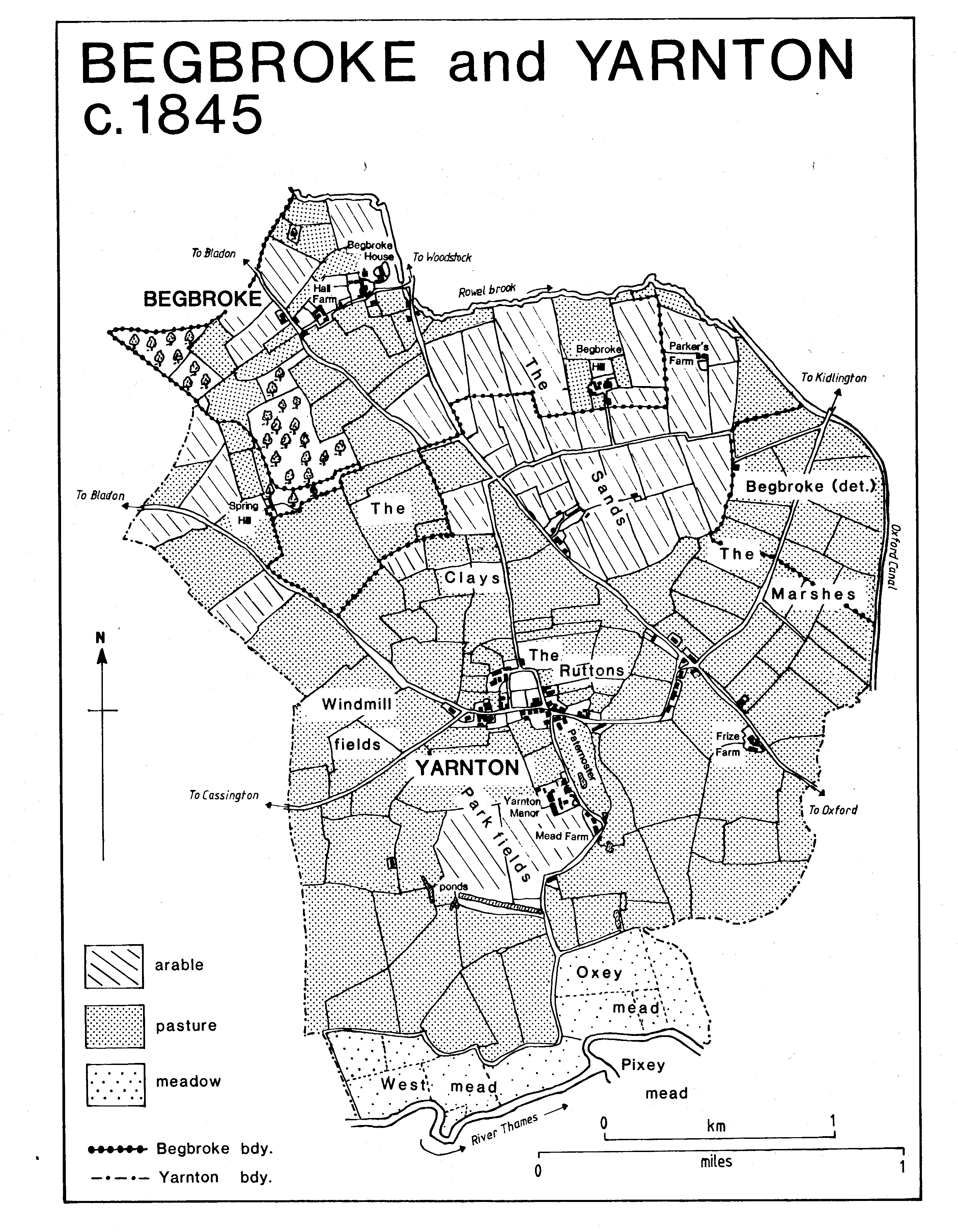
Begbroke is a small parish 4 ½ miles (c. 7 km.) north–west of Oxford on the Oxford–Woodstock road. (fn. 1) Its area until 1932 was 577 a., including a detached portion of 118a. in the north–east corner of Yarnton parish which was then taken into Yarnton. (fn. 2) In 1948 part of Kidlington, c. 144 a. east of the Oxford–Woodstock road and north of Rowel brook, was transferred to Begbroke, (fn. 3) bringing the total area of the civil parish to 603 a. (244 ha.). The ancient parish was bounded on the north by Rowel brook and on part of the south–west by Frogwelldown Lane, an ancient route; elsewhere the boundary had an artificial appearance, following straight field boundaries.
The land slopes gently from c. 100 m. in the west to c. 70 m. at the village, while to the east it is almost flat. Most of the parish lies on Oxford clay, but there is an area of sand and gravel east of the Oxford–Woodstock road, and it was there that the manor house and farm buildings of Begbroke Hill were built in the early 17th century; (fn. 4) the main settlement is on the clay, relatively unusual in Oxfordshire. The geological division within the parish is reflected in field names such as the Clays in the west, and the Sands in the east. The western edge of the parish is well wooded. Begbroke wood, comprising 40 a., of which 8 a. lie in Yarnton, was mentioned from the late 17th century, (fn. 5) and was valued both for its timber and for its 'far famed' reputation as a game preserve. (fn. 6) Muntjac deer have been introduced into the wood in the 20th century.
The Oxford–Woodstock road was turnpiked in 1718 and disturnpiked in 1878. (fn. 7) The road from the turnpike into the village, known in the early 19th century as Watery Lane, was said in 1820, shortly before it was widened and remade, to be a 'hollow lane, dark, damp, and dirty', too narrow to allow carriages to pass. (fn. 8) Dalton, or Dolton, Lane running south from the west end of the village to the Oxford–Woodstock road may have formed part of an ancient route; it was called Green Lane in 1844, (fn. 9) and further north continues as a footpath to Bladon. A lane which ran from Watery Lane east of the rectory was suppressed in 1823. (fn. 10) Begbroke was served by carriers operating to and from Oxford, and occasional carrying services were offered by landlords of the Sun inn. (fn. 11)
Traces of early settlement have been discovered in Begbroke and Yarnton near Begbroke Hill, (fn. 12) but the Saxon village of Begbroke ('Becca's brook') (fn. 13) was built c. ¾ mile to the northwest. Its population was small in 1086, when 9 tenants were recorded, and in 1279, when there were 13. (fn. 14) There had probably been a fall in population by 1377, when only 33 persons over the age of 14 were assessed for poll tax. (fn. 15) Later assessments suggest little expansion before the 19th century: in 1428 there were said to be fewer than 10 households in the parish, (fn. 16) 20 people took the Protestation Oath in 1642, (fn. 17) 5 households were assessed for the hearth tax of 1662, (fn. 18) and 41 adults were recorded in 1676. (fn. 19) Between 1738 and 1774 the number of households in the parish varied from 11 to 15, (fn. 20) and there were 15 in 1801, when the population was 80. A rise to 118 in 1811, followed by a fall to 102 in 1821, was attributed to the temporary presence of a girls' boarding school. The population remained at c. 100 thereafter until falling to 80 in 1871 and to a low point of 68 in 1881. A slight recovery followed, and in 1931 the population was 111. In the 1930s workers in Oxford began to live in Begbroke, and by 1951, with the inclusion of 101 people transferred from Kidlington in 1948, Begbroke's population had risen to 360. Between 1971 and 1981 it rose from 567 to 755, proportionally one of the largest increases in the area. (fn. 21)
The old village lies west of the Oxford–Woodstock road and is approached by Spring Hill Road, formerly Watery Lane, overhung by mature horse–chestnut trees which serve to insulate the village from the heavy traffic of the main road. A narrow road, St. Michael's Lane, branches north to the church, which stands at the north–east edge of the village, and Spring Hill Road continues south–westwards to the junction with Dalton Lane. There seem to have been two main areas of housing, at each end of the village street and perhaps representing two manorial centres. East of the church and rectory house stands St. Philip's Priory, whose predecessor may once have been the chief house of Studley priory's Begbroke estate. Nearby, west of the church and south–east of the village street, were houses of the FitzHerbert manor. Orchard House, bearing the dates 1692 and 1694 and the initials of Thomas FitzHerbert (d. 1700), stands south–west of the church, possibly on the site of what was the FitzHerbert manor house until the building of Begbroke Hill. It is a plain, twostoreyed, stone house, greatly altered and enlarged in the 19th and 20th centuries. A drawing of the church in 1801 appears to show a dovecot west of the churchyard wall, presumably belonging to the house. (fn. 22) At the west end of the street, known as Village End, there were formerly some cottages, and the end is dominated by Hall Farm, possibly the site of the manor house of the Lyons, later the Spencer, manor. South–east of the farmhouse was the parish pound. (fn. 23) Begbroke lacks, and perhaps never had, the large number of small 17th– and 18th–century yeoman houses common elsewhere in the area. In 1838 more than half the houses in the village were dismissed as 'poor cottages', (fn. 24) and several, along the main road near the Royal Sun inn and along the lane leading to the church, were demolished in the 19th century. (fn. 25) The Royal Sun was probably the 'disorderly house' reported to the magistrates in 1711 and 1745 as kept by the Tarrant family. (fn. 26) Referred to from 1774 as the Sun, (fn. 27) it acquired its prefix c. 1915. (fn. 28) It is an 18th–century building of coursed rubble, and retains a double rectangular plan, but the interior has been repeatedly altered.
Begbroke and Yarnton c.1845
The former schoolhouse, dated 1820 but of an earlier build, was demolished in the 1960s and replaced by a large stone house incorporating the datestone of the earlier dwelling. (fn. 29) In 1844 an isolated cottage, part of the FitzHerbert estate, stood next to the Bladon path at Village End; parts of the building appear to survive in a later house on the site, but they have been almost completely submerged by later additions. On the north side of Spring Hill Road east of Hall Farm a pair of brick labourers' houses of the later 19th century stand on sites occupied by two cottages in 1844. (fn. 30) Until its closure in 1984 St. Juliana's convent school, opposite the southeast corner of St. Michael's Lane, occupied the site of a house included in the partition of the FitzHerbert estate in 1804. (fn. 31) That house or a successor, known as the Elms in the later 19th century, (fn. 32) was rebuilt in ironstone in 1888. (fn. 33) It was bought in 1905 by Charles Robertson, who enlarged it in 1906, renamed it Begbroke Place and gave it in 1908 to be a hostel for Roman Catholic priests, a role it served until 1924. (fn. 34) It has become, with the addition of school buildings in 1940 and 1968, (fn. 35) the largest group of buildings in the village. It was bought in 1986 by Solid State Logic Ltd., a leading manufacturer of broadcasting and recording equipment, which transferred its headquarters there from nearby Stonesfield and began a large–scale expansion on the site. (fn. 36) Since the demolition of the cottages south of the Royal Sun the only houses along the west side of the road are a stone house in the grounds of St. Philip's Priory, and, to the north, Priory Cottage. The only remaining 19th–century house east of the main road is a small stone house with brick dressings in Fernhill Road, formerly in Kidlington.
It was said in 1935 that no new houses had been built in Begbroke since 1918, and that a fifth of the families in the parish were living in overcrowded conditions. (fn. 37) Although there are a few modern houses in the old village the wide and busy main road to some extent divides Begbroke into two communities. Housebuilding east of the road began in the 1930s, in response to demands from newcomers to the area, many of them workers at the Cowley motor factories. The earliest houses and bungalows, along the main road and in Begbroke Lane and Fernhill Road, were of good quality and were on spacious plots typical of the better garden suburbs of the period. Development after 1945 was more intensive, and housing estates have spread steadily eastwards on both sides of Begbroke Lane. Begbroke was connected to the Oxford water supply in 1934. (fn. 38) A village hall was built in 1947 in Begbroke Lane, (fn. 39) and was rebuilt c. 1975. (fn. 40)
The Agricultural Research Council's Weed Research Organisation was established at Begbroke Hill in 1960, and acquired an international reputation. (fn. 41) Government economies forced its closure in 1985, and its staff was dispersed to other research establishments.