A History of the County of Stafford: Volume 17, Offlow Hundred (Part). Originally published by Victoria County History, London, 1976.
This free content was digitised by double rekeying. All rights reserved.
A P Baggs, G C Baugh, C R J Currie, Johnson D A, 'Smethwick: The growth of the town', in A History of the County of Stafford: Volume 17, Offlow Hundred (Part), ed. M W Greenslade (London, 1976), British History Online https://www.british-history.ac.uk/vch/staffs/vol17/pp88-96 [accessed 30 April 2025].
A P Baggs, G C Baugh, C R J Currie, Johnson D A, 'Smethwick: The growth of the town', in A History of the County of Stafford: Volume 17, Offlow Hundred (Part). Edited by M W Greenslade (London, 1976), British History Online, accessed April 30, 2025, https://www.british-history.ac.uk/vch/staffs/vol17/pp88-96.
A P Baggs, G C Baugh, C R J Currie, Johnson D A. "Smethwick: The growth of the town". A History of the County of Stafford: Volume 17, Offlow Hundred (Part). Ed. M W Greenslade (London, 1976), British History Online. Web. 30 April 2025. https://www.british-history.ac.uk/vch/staffs/vol17/pp88-96.
THE GROWTH OF THE TOWN.
Before the 19th century the main centre of population seems to have been Bearwood Hill at the junction of the Birmingham-Dudley road and the road from Harborne (now Bearwood Road). (fn. 1) It was an inhabited area by 1278, (fn. 2) and the name Bearwood Hill was in use by the early 18th century. (fn. 3) The name was also used for the adjoining stretch of the BirminghamDudley road, which was renamed High Street c. 1906. (fn. 4) Cottages which stood until c. 1906 at what is now the northern end of Cheshire Road dated from at least the early 18th century. (fn. 5) The earliest buildings surviving in 1971 were the two pairs of early19th-century cottages on the north side of Firs Lane. The area in the fork between the two main roads, by 1971 cleared of buildings and planted as a public garden, was formerly known as Newlands Green, apparently after William Newland, a Congregationalist wheelwright who lived there and owned property there in the early 19th century; (fn. 6) the name is still used for the street linking the two roads. The Red Cow inn, dating from at least the 18th century, formerly stood at Newlands Green; it was rebuilt on its present site further north in High Street in 1936-7. (fn. 7) The Sow and Pigs, which existed by 1818, (fn. 8) stood to the south of the former site of the Red Cow. Smethwick Cross at Bearwood Hill is mentioned in the 17th and earlier 18th centuries; it may have been a wayside cross, or the name may simply refer to the road junction. (fn. 9) Waterloo Road to the south-east (formerly Shireland Lane) formed part of an old road leading to Handsworth; it was the scene of the final stages of the battle in 1643 which resulted in Prince Rupert's capture of Birmingham. (fn. 10) By 1771 there was settlement west of Bearwood Hill at Bosoms End (also called Blossoms End by 1839), which lay around the triangle formed by the streets now called the Uplands, Cemetery Road, and Parkes Street. A road ran south-east from the area across Bearwood Road to Waterloo Road—the line of the present Uplands, Church Road, and Grange Road. (fn. 11)
It was not until the end of the 19th century that extensive development began to take place around Bearwood Hill. By the beginning of the 20th century nearly all the streets of houses south-east from Bearwood Hill to Waterloo Road and on the southwest around Wellington Road had appeared, and in 1900 Cheshire Road was being built up, particularly on its eastern side. The block of streets to the north-east of the Bosoms End triangle had also appeared, and the terrace on the west side of Cemetery Road was built in 1900-1. (fn. 12) Victoria Park was laid out to the east of Bearwood Hill in 1887-8 on 35½ a. around Pool Farm (formerly Berwoods Hill Farm) bought by the local board from Majorgeneral E. M. Studd; it was extended in 1894 when land near Crockett's Lane was added. (fn. 13) Harry Mitchell Park north of Parkes Street was laid out on 6 a. of the land which Henry Mitchell conveyed to the corporation in 1899 in memory of his son Harry. (fn. 14) The Council House was built in 1905-7 in High Street at the north-west corner of Victoria Park. (fn. 15) By 1914 the streets west of Cheshire Road and the streets between the Uplands and the cemetery had been built up; Capethorn Road, running from Waterloo Road to Bearwood Road, was built up after the demolition in 1908 of Capethorn, a house of c. 1800. (fn. 16) The council estate at the corner of Bearwood and Church Roads was built around 1950; it consists of four-storey blocks containing twostorey dwellings one above the other and twostorey blocks of old people's maisonettes. (fn. 17) The flats on the south side of Newlands Green are a little later. (fn. 18) Bearwood House, a 15-storey block of council flats at the north end of Bearwood Road, was opened in 1966. (fn. 19)
Until the period between the World Wars the district further west remained open country, with several farms and large houses. (fn. 20) Smethwick Old Church was built there in 1732 and its school about the same time. Old Chapel farm, part of the estate with which Dorothy Parkes (d. 1728) endowed the church, lay to the west. (fn. 21) The Old Chapel public house to the north of the church dates from c. 1800. Smethwick Hall (formerly Smethwick House), which stood at the west end of Stony Lane until 1937, is said to have been built in 1746, and Spout House to the south-east, also demolished in 1937, existed by the late 18th century. (fn. 22) Between the World Wars, however, the area, like the adjoining part of Oldbury which was added to Smethwick in 1928, was used for new council estates, with the earliest of the borough's council housing being built in Hales Lane. Over 42 a. south of Church Road and in Hales Lane, including Old Chapel Farm, were sold by the trustees of Dorothy Parkes in 1927 and laid out for housing. The footpath running from Cemetery Road to Londonderry Lane became Manor Road, and streets of houses were built on either side. (fn. 23) In 1928 the corporation acquired the Smethwick Hall estate and opened Smethwick Hall Park on part of it in 1930; in 1939 schools were opened on the site of the Hall. (fn. 24) The corporation continued to use the western district for new estates after the Second World War, but because of the shortage of land it built blocks of flats and maisonettes instead of houses. The blocks in Cemetery Road known as Thompson Gardens were erected in 1959-61 on the site of the Uplands, a villa built in 1847 by Samuel Thompson and demolished in 1958. The development includes a 15-storey block of flats, the first of several of that height in the town. Brookview at the junction of Stanhope Road and Beakes Road is a similar development of the same date and includes a 12-storey block. (fn. 25)
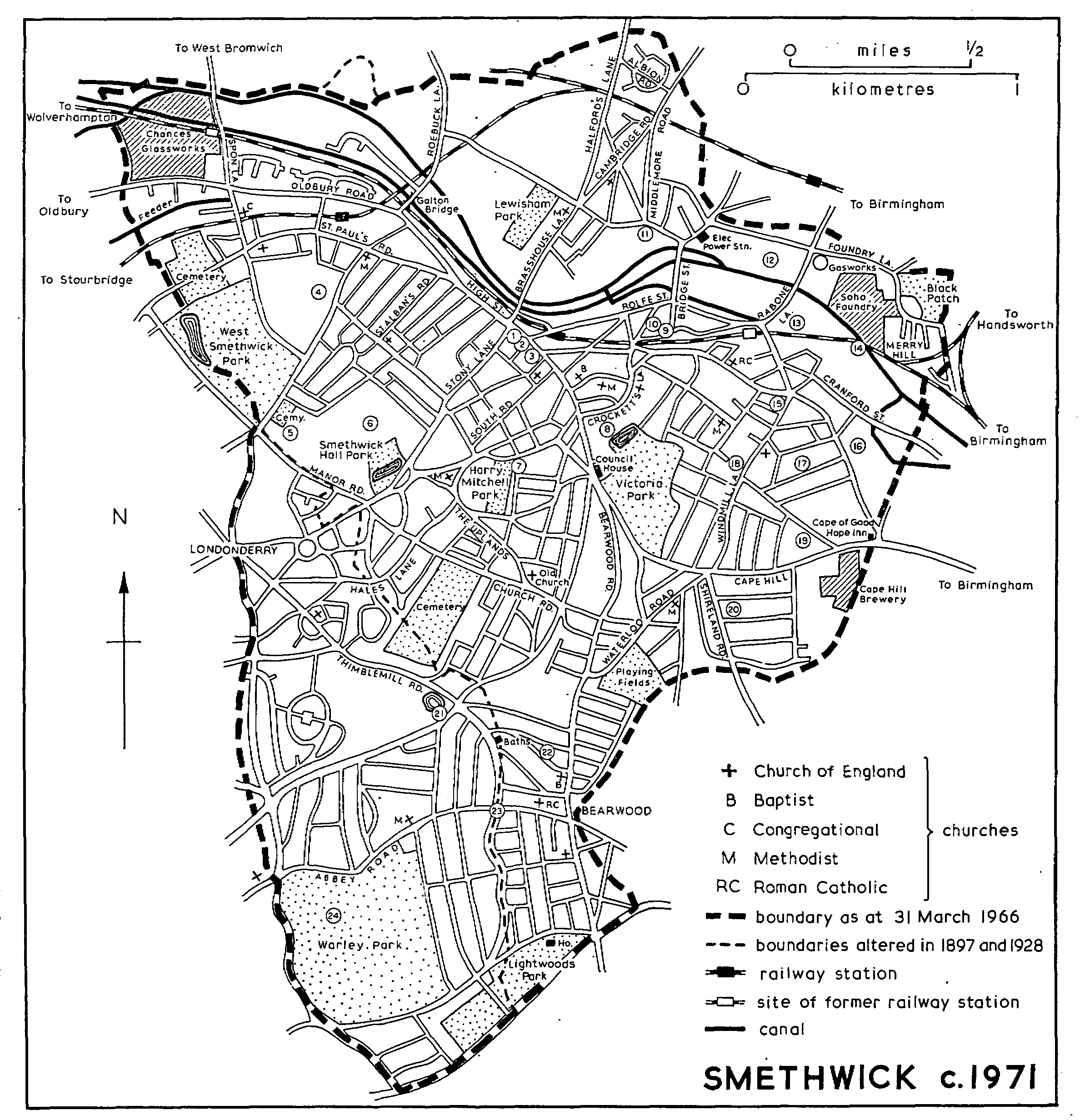
SMETHWICK c. 1971
KEY 1. Site of former public library 2. Central library, formerly the public buildings 3. Sikh temple, formerly Congregational church 4. Former Holly Lodge 5. Midland Centre for Neurosurgery and Neurology, formerly infectious diseases hospital 6. Site of Smethwick House, later Smethwick Hall 7. Henry Mitchell Alms-houses 8. Chance Building, Warley College of Technology 9. Site of 1826 Wesleyan Methodist chapel 10. Site of 1856 Wesleyan Methodist chapel 11. Site of the Ruck of Stones 12. Site of Smethwick Hall 13. Site of the French Walls 14. Site of Piddocks (later Cranford) Farm 15. Site of Presbyterian church 16. Site of Smethwick Grove 17. Site of the Woodlands 18. Site of windmill 19. Site of the Coppice 20. Site of Shireland Hall 21. Site of Thimble Mill 22. Site of Beakes Farm 23. Site of Three Shires Oak 24. Site of Warley Abbey
The district to the north of Bearwood Hill became the new centre of Smethwick in the 1830s. Earlier it consisted of scattered settlement along the Birmingham-Dudley road. The Blue Gates inn on the corner of Stony Lane probably existed by the 1770s. (fn. 26) There were then some buildings at the end of Crockett's Lane (which as late as 1868 was also known as Berwood Lane). (fn. 27) Building-plots at the corner of Stony Lane and apparently at the corner of Cross Street were offered for sale in 1824. (fn. 28) With the opening of the new line of the Birmingham Canal in the later 1820s the New Village grew up; it lay on the east side of the main road and was predominantly an area of factories and workers' houses. (fn. 29) By 1836 Cross, New, and Bridge Streets had been laid out and numerous houses had been built there. (fn. 30) Holy Trinity Church was being planned in 1835 and was built in 1837-8 on a site on the west side of the main road. (fn. 31) At that point the main road reaches the top of a slope, and the height of the summit was lowered at the time of the building of the church to ease the climb up from the Blue Gates. (fn. 32) Schools too were being opened in the area from 1836. (fn. 33) Rolfe Street existed by 1839, and by the middle of the century it had become the commercial centre of Smethwick, lined with shops, works, business premises, and numerous public houses. A railway station was opened there on the Birmingham, Wolverhampton & Stour Valley line in 1852. Rolfe Street retained its pre-eminence until the later part of the century when Soho Street became the shopping centre of the town; the decline was apparently caused by the closure of several works and also by the demolition of property in the late 1880s when a railway bridge replaced a level crossing. (fn. 34) Union Street was being built up by 1841. (fn. 35) Both it and Cross Street had apparently been laid out by one of the Downing family. (fn. 36) Regent Street was begun between 1868 and the late 1870s. (fn. 37) Piddock Road dates from c. 1907. (fn. 38) Most of the housing in the streets on the east side of the main road was demolished in 1970-1.
The area west of the main road developed at first as a middle-class district around Holy Trinity Church. J. W. Unett of the Woodlands laid out the streets flanking the churchyard on the north, west, and south in the later 1830s. Within the next decade he had also built Broomfield south-west from Queen Street, itself described as new in 1842. South Road was built up from the 1840s by John Harley, a Smethwick builder, who was later joined by his son James; by 1850 Belle Vue Terrace had been built there, with business and professional men as residents. As the development spread westwards the houses became larger; they are characterized by heavy stucco decoration. The district north-west to Holly Lane dates mainly from the late 19th and early 20th centuries. (fn. 39) Several of the streets between Stony Lane and Holly Lane have Devonshire names because Samuel Dibble, the founder of the firm that built them, and George Bowden, the architect, were natives of that county. Plans for making that part of the area into a separate parish were first mooted in 1899. By 1903 some 3,000 people were living there, and it continued to expand as a working-class district. (fn. 40) Most of the streets to the south-west of Devonshire Road were built up from the early 1930s. (fn. 41) There was rebuilding on the west and north sides of Holy Trinity Church in the 1950s and 1960s, with government offices on the site of the 1839 vicarage house and a post office on the site of the National school of 1840-1. (fn. 42) A council estate was being completed in 1971 between High Street and Holly Street, obliterating Queen and James Streets.
The area in the north-west of the former borough, known as West Smethwick by 1857, (fn. 43) developed in the 19th century as a distinct community focused on the Chance glass-works, with shops around the southern end of Spon Lane. (fn. 44) Spon Lane itself is mentioned in 1694. (fn. 45) In the later 18th century there were houses along the Birmingham-Dudley road (the present Oldbury Road) and several small farms, some of which survived until the later 19th century. (fn. 46) Blakeley Hall farm, said to have belonged to Halesowen abbey (Worcs.), lay on the north side of the main road, between Spon Lane and the Oldbury boundary, and in 1810 was 35 a. in extent. (fn. 47) Holt Hill farm, the home of the Birch family in the earlier 18th century, covered 79 a. in the Roebuck Lane area in 1780. (fn. 48) A farm on the west side of Holly Lane can also be traced from the earlier 18th century. (fn. 49) The Swan inn, which stands on the corner of Holly Lane and Oldbury Road, apparently existed by 1733, (fn. 50) although the present inn dates from the 20th century. The earliest surviving building is a late-18th-century house, no. 493 Oldbury Road, by 1971 used as commercial premises; near by on either side of the road there are some terraced cottages of the earlier 19th century. By 1810 part of Blakeley Hall farm had been divided into building plots, and several cottages were subsequently erected there. (fn. 51) The development of the area, however, began with the opening of Thomas Shutt's glass-works beside the Birmingham Canal on part of the farm apparently in 1815; the works was bought by R. L. Chance in 1822. (fn. 52) By the mid 1840s there were about 300 people living in Scotch Row in some 40 cottages belonging to the works. (fn. 53) George Street on the east side of Spon Lane existed by the mid 1840s, and by 1857 the area was built up as far as West Street. (fn. 54) With the completion of the Birmingham, Wolverhampton & Stour Valley railway through Smethwick in 1852 a station was provided in Spon Lane. (fn. 55) When St. Paul's Church was opened in 1858, it was stated to have been built for the needs of a population of over 2,700 in the Spon Lane area. (fn. 56)
The part of West Smethwick lying south of Oldbury Road developed later. The stretch of what is now St. Paul's Road from High Street to Holly Lane had been built by 1816, (fn. 57) but its continuation westwards was described as newly made in 1857. (fn. 58) In 1826 there were two newly built streets running south from Oldbury Road: Downing Street (the site of which is occupied by Smethwick West station of 1867) and Pleasant Street (the present Nine Leasowes). (fn. 59) Church Street West (now Mallin Street) and Church Street (now Marriott Street) were newly laid out in 1857 but were not then built up. (fn. 60) Much of the district had been developed by the later 1880s, but the area south-east of St. Paul's dates from the late 19th and early 20th centuries and the Lonsdale Road area from the early 20th century. (fn. 61) West Smethwick Park was opened in 1895 on 43 a. given, laid out, and endowed by James Timmins Chance (later Sir James Chance, Bt.); he added more land in 1896, bringing the park to 50 a., a small part of it on the Oldbury side of the borough boundary. At first it was in the hands of trustees, but they conveyed it to Smethwick corporation in 1912. Chance also built Park Road (now West Park Road) and Victoria Road (in Oldbury) along the eastern and western boundaries of the park. (fn. 62)
An estate of prefabricated houses was built in Summit Crescent between the two levels of the Birmingham Canal west of Roebuck Lane in the later 1940s; (fn. 63) by 1971 they had been replaced by an industrial estate. The council estate on the north side of Oldbury Road, which has obliterated the 19th-century street pattern, dates from the late 1960s, and the multi-storey flats on the opposite site of the road are of the same period. (fn. 64) In 1971 further redevelopment was in progress on the south side of Oldbury Road to the east of Marriott Street. The small area of West Bromwich added in 1966 (fn. 65) is occupied by a stretch of the M5 motorway and part of the West Bromwich ring road.
The district in the extreme north of the town beyond the Birmingham Canal developed as an industrial area mainly in the later 19th century and included the only colliery in Smethwick as well as numerous factories. It is crossed by an old road which joins the Birmingham-Wolverhampton road at the former Street House in the south-east of West Bromwich. The road has had several names, the oldest being Bowling Alley Lane and Street House Lane; land in Street House Lane variously called the Bowling Alley and the Bowling Green was owned by the Pope family in the earlier 19th century. The name Brasshouse Lane was also in use by the mid 1830s, and Halford's Lane was yet another version by 1851, deriving from the name of the family who had occupied Street House. By the later 1880s the southern part of the road, as far as the junction with Dartmouth Road, was called Brasshouse Lane and the rest Halford's Lane. A footbridge over the railway replaced a level crossing as part of the improvements in the area in 1888-90; the High Street end of Brasshouse Lane was thus blocked to vehicles, and North Western Road was built as a link to Rolfe Street. (fn. 66) Much of the area was formerly occupied by the Ruck of Stones farm, which can be traced from the late 16th century. (fn. 67) Another farm, between Halford's Lane and Roebuck Lane, can be traced from the early 18th century. (fn. 68) Galton House between the two levels of the canal on the east side of Roebuck Lane existed by 1790. It was probably connected at one time with the Galton family, but it was owned by the Birmingham Canal Navigations by 1842 and was occupied by the company's agents for some years; it was demolished c. 1916. (fn. 69) Hadley House on the east side of Brasshouse Lane south of Lewisham Road existed by 1816. It was the home of Joseph Hadley, an ironmaster, in the mid 1830s and of T. R. B. Bindley, founder of a near-by glue factory, in 1851; it still stood in 1913 but has since been demolished. (fn. 70) A spring issuing from the side of the canal cutting near Roebuck Lane and known as the Sugar Well from the white deposit left by the water formerly attracted people from a considerable distance because the mineral content of the water was said to be good for eye complaints. (fn. 71)
The brasshouse from which the lane took its name existed by 1790; there were a steelworks and rolling-mills on the north bank of the canal east of Brasshouse Lane by 1842; drain-pipes were being made in Pottery Lane from c. 1850. (fn. 72) There were several houses in Brasshouse Lane and in Ruck of Stones Lane (now Lewisham Road) by the mid 1830s. (fn. 73) They included the block of twenty houses in Brasshouse Lane which evidently existed by 1816 and which was known by the 1850s as Twenty House Row. (fn. 74) About 1840 Daniel Holloway, a coaldealer, built himself a house in Halford's Lane which c. 1860 became the public house called The Old House at Home; in 1855 he also built eight cottages on adjoining land. (fn. 75) What was called Arthur Street in 1851 and Great Arthur Street by the late 1880s existed by 1842, and houses had been built there by 1857; only the eastern part existed then, and it was extended to Roebuck Lane apparently in the 1940s. (fn. 76) By 1851 St. George Street (now Perry Street) was being built up. (fn. 77) There was also some building by 1852 at the east end of what was later called Dartmouth Road, but most of its course to Roebuck Lane was evidently still a track; the road was made c. 1865 and follows a more northerly line. (fn. 78) The Birmingham, Wolverhampton & Dudley Railway was opened through the area in 1854. (fn. 79) In 1864 the Birmingham Wagon Co. (later the Birmingham Railway Carriage and Wagon Co.) built its works beside the railway off Middlemore Road; (fn. 80) the manager, Edmund Fowler, built himself a house, the Laurels, to the north-east and converted Middlemore Road from a bridlepath into a highway. (fn. 81) In 1874 the first sinking was completed at the Sandwell Park Colliery, also beside the railway. (fn. 82) By 1881 the area had a population of over 2,500 and was still expanding. Some 60 cottages were being built towards the end of that year, and a large number of building sites had been marked out. (fn. 83) By the later 1880s Mornington Road, Pope Street, and part of Middlemore Road had been built up, and the terraces known as Sandwell Place between Halford's Lane and Oxford Road had been erected. Oxford, Cambridge, and Sydenham Roads had been laid out, and they were built up soon afterwards. Mafeking and Kimberley Roads date from the early 20th century. (fn. 84) Lewisham Park on the south side of Dartmouth Road was leased to the town by Lord Dartmouth at a nominal rent and was opened in 1905; the area had been part of a bowling alley and later a football ground for the Birmingham Railway Carriage and Wagon Works. (fn. 85) Several factories have been built on either side of Dartmouth Road in the 20th century; the earliest was the 1905 portion of the works of Henry Hope & Sons on the corner of Halford's Lane. (fn. 86) Middlemore Industrial Estate was developed on the 56-acre site of the Birmingham Railway Carriage and Wagon Works after it had ceased production in 1963. (fn. 87) Extensive demolition of the 19th-century terraced housing was in progress in 1971. In 1966 the northern boundary was changed by the transfer to West Bromwich of the area on either side of Halford's Lane north of the railway, occupied largely by the Albion council estate built between the World Wars. (fn. 88)
The area in the north-east of the town became steadily industrialized from the late 18th century, with factories being built on either side of the Birmingham Canal. It is crossed by an old road to Handsworth, known in 1815 as New Inn Lane and by 1851 as Rabone Lane. (fn. 89) Bridge Street existed by the 1770s, running from Rabone Lane to the Ruck of Stones area. (fn. 90) Slough Lane (now Wellington Street) on the Birmingham boundary occurs from 1622 as Slowe or Sloe Lane; Slowe Moor too occurs in the area from that date. (fn. 91) The name may even have been in use c. 1275 when Agnes de Slouf occurs among the tenants of Smethwick manor. (fn. 92) It was stated in 1884 that the name derived from the sloes that had abounded in the area within living memory; (fn. 93) the earlier existence of Fenfield in the area (fn. 94) suggests 'slough' as an alternative derivation. A farm called the French Walls, Piddocks farm, and probably Smethwick Hall (later Rabone Hall) existed by the mid 17th century. (fn. 95) Soho Foundry was opened in 1796, and a gun-barrel factory was built at the French Walls about the same time. (fn. 96) A row of cottages off Foundry Lane, used in 1972 as offices by the Foundry, existed by 1814. (fn. 97) Part of the Merry Hill area near the Birmingham boundary became known as the Soap Hole from the soapworks established there by 1818. (fn. 98) By the mid 1830s there were numerous houses as well as new factories. (fn. 99) The French Walls became the site of G. F. Muntz & Co.'s metal works in 1842 and Rabone Hall the site of Tangye Bros. & Price's Cornwall engineering works in 1864. (fn. 100) The area is crossed by the Birmingham, Wolverhampton & Stour Valley Railway, completed in 1852; a station was opened at Soho in 1853. (fn. 101) The gas-works in Rabone Lane dates from 1881 and the power station in Downing Street from c. 1900. (fn. 102) The area occupied by Black Patch Park in the north-east corner of Smethwick was originally part of a larger open space extending into Handsworth and Birmingham and used in the later 19th century as a gypsy encampment. The owners of the land evicted the gypsies in 1904, and the park was laid out by the city of Birmingham in 1910-11. In 1966 it was taken over by the new borough of Warley. (fn. 103) In the mid 1960s the Vittoria Street area was redeveloped with council housing, including a 15-storey block; (fn. 104) the street was divided into two separate parts, the northern half becoming Boulton Road. The north-eastern boundary was changed in 1966 by the addition of a small part of Birmingham. (fn. 105)
The Cape Hill, Windmill Lane, and Shireland Road areas to the south-west of this industrialized part of the town developed largely as a district of workers' houses, with factories on the eastern boundary and a new commercial centre along the Birmingham-Dudley road and part of Waterloo Road. Besides the main road two other old roads cross the area, running north to Handsworth along Grove Lane (formerly Cape Lane) and along Windmill Lane (taking its name from the windmill built at the beginning of the 19th century). (fn. 106) There were formerly several farms and extensive woodland; the area was also one where Birmingham business and professional men settled from the later 18th century. (fn. 107) In 1850, however, it was stated that anyone proceeding along Grove Lane to the New Village would see 'nothing but new-formed streets, and others staked out, and group after group of tenements'. (fn. 108)
The Cape Hill district takes its name from the Cape of Good Hope inn which stood by 1814 at the junction of Grove Lane and the main road. The present building, apparently the third on the site, was opened in 1925. (fn. 109) There was still little building in the area in 1842, although the present Raglan Road, Reynolds Street, and Wills Street were then described as 'intended new streets'; twelve houses were being built in Reynolds Street. (fn. 110) At the junction of Waterloo Road and the main road stood Berwood Cottage. It belonged to William Spurrier (d. 1848), a Birmingham lawyer, who owned 214 a. in Smethwick. He had lived in Smethwick earlier in the century, but by 1842 Berwood Cottage with 7 a. attached was occupied by William Mather. It was known locally as Blood Hall because Spurrier acted for the Crown in prosecutions for forgery and coining. The Elms was built on the site by Dr. William Sutton c. 1875 and was replaced by Lloyds Bank in 1907. (fn. 111) Cranford Street existed by 1847, presumably taking its name from Cranford farm, (fn. 112) and Poplar and Lower Cross Streets were built by J. W. Unett of the near-by Woodlands c. 1848. (fn. 113) The area east of Grove Lane had by then become industrialized. (fn. 114) In 1854 the site for St. Matthew's Church on the east side of Windmill Lane was conveyed by Unett; the conveyance mentioned land to the north-east and south-west belonging to Unett over which it was planned to make new streets. (fn. 115) By 1857 Upper Grove Street and London Street existed, both with some houses; there was also building around the Six Ways junction at the north end of Windmill Lane. (fn. 116) The failure in 1856 of Fox, Henderson & Co. of the London Works in Cranford Street caused a decline in the district for some years. Richard Tangye visited the area soon after the failure and later recalled the deserted and grassgrown streets and rotting doors and windows; the workers had left, and the small shopkeepers were ruined. (fn. 117) The first part of Cape Hill Brewery was built on the south side of the main road in 1878-9. (fn. 118) Further development took place in the 1880s after the break-up of the Coppice and Woodlands estates, and the whole triangle between Windmill Lane, Grove Lane, and the Cape Hill stretch of the main road was built up by the beginning of the 20th century. (fn. 119) The two-storeyed blocks on the south side of Cape Hill inscribed 'Smethwick Market' and 'Cape Hill Market' (now shops on the ground-floor and living accommodation on the first floor) had been built by the late 1880s and represent the beginning of the shopping centre which now extends part of the way along Shireland and Waterloo Roads. (fn. 120) Covered markets have been held in Windmill Lane since at least the later 1920s in place of earlier open-air markets. (fn. 121) Extensive redevelopment of the area between Raglan Road, Windmill Lane, and Grove Lane with council housing, including multi-storey flats, started in the earlier 1960s. (fn. 122)
The west side of Windmill Lane began to be developed about the mid 19th century. Earlier in the century there was only the windmill, Oakfield farm to the east, and a row of houses (called High Park Row and later Hill Row) on the west side of what is now Soho Street. (fn. 123) About 1850 the group of streets between the windmill and the main road were laid out—Ballot, Suffrage, Corbett, and Hume Streets. Building there, however, was piece-meal over the next half century. (fn. 124) By the mid 1850s Price Street and the streets north to Messenger Road (formerly part of High Park Road) had been laid out, but building there too was scattered. (fn. 125) High Park Road occurs by the mid 1850s and was then known also as Hyde Park Road; there was a Hyde Park Leasow on the east side of Soho Street in 1842. (fn. 126) The streets south from Price Street to Ballot Street were built in the earlier 1880s; nearly 70 years later an old man recalled the process: (fn. 127)
About 1882 a man named Mackey started to build in Exeter Road, about twelve houses near Corbett Schools . . . Then in '83 or '84 Dibble came on the scene, started to make streets, and Sewer started to build in Tiverton Road in blocks of eight. They flew up, not much foundations . . . Brickies first, then slaters, carpenters, doors and windows already made, and that is how Tiverton, Exeter, Bolham, and Bampton Roads were made.
Devonshire names were given to several of the streets because Samuel Dibble was a native of Devonshire. (fn. 128) The Windmill Brewery in Windmill Lane was built in 1886-7. (fn. 129) The Soho Street area became the shopping centre of Smethwick c. 1890 with the decline of Rolfe Street but was later superseded by Cape Hill. (fn. 130) The whole area between the main road and Messenger Road had been built up by the beginning of the 20th century; Victoria Park Road and Pool Road were also being built up by then. (fn. 131) The corporation began to redevelop the area north from Suffrage Street to Messenger Road in 1954, and building was still in progress in 1971. It consists almost entirely of blocks of maisonettes and flats, some of them 15 storeys high, and there is also a shopping precinct. (fn. 132) Council flats were also built to the north of Messenger Road in the mid 1960s. (fn. 133)
The Shireland Hall estate to the south of Cape Hill existed by the later 17th century. (fn. 134) The northern half of Montague Road had been built by 1854, (fn. 135) and in 1856 there were plans for developing part of the estate. (fn. 136) In fact it was some time before the new district began to be laid out. Shireland Road had been built apparently by 1877, (fn. 137) and in 1881 mention was made of the large and rapidly increasing population on the Shireland Hall estate, consisting mainly of workers who wanted to live nearer their place of work. (fn. 138) Houses were being erected in Florence Road in 1886 by Thomas Butler, a Handsworth builder. (fn. 139) Most of the streets between Montague and Waterloo Roads had been laid out by the later 1880s. An appeal in 1901 for the new church then being built in Shireland Road in place of a mission church of 1882 gave the population as over 7,000; it was still rapidly increasing and consisted entirely of workers in the factories of the district. (fn. 140) Hadley Playing Fields at the south end of Waterloo Road were opened in 1962; much of the site had long been used for recreation. The land was left to the corporation by Sarah Hadley (d. 1936) of the adjoining Bell House, which stood on the corner of Waterloo Road and Bearwood Road and was demolished in 1959 to allow for road widening and the laying-out of the playing fields. (fn. 141)
Bearwood, which forms the southern extremity of Smethwick, was in the later 18th century still an area of extensive woodland, a feature from which the 18th-century Lightwoods House takes its name. (fn. 142) A tree known as the Three Shires Oak stood at what is now the junction of Three Shires Oak Road, Thimblemill Road, Wigorn Road, and Abbey Road, where Staffordshire adjoined detached portions of Shropshire and Worcestershire; it was cut down in 1904. (fn. 143) A plot of arable on the south side of Three Shires Oak Road was known as the Bear Wood in the 1830s. (fn. 144) The Beakes, a moated farmhouse formerly standing west of Bearwood Road, existed by the late 17th century. (fn. 145) By 1775 there was some building at the cross-roads formed by the ancient road running from Harborne to Smethwick (the present Bearwood Road) and the road from Rowley Regis to Edgbaston (here following Three Shires Oak Road and Sandon Road, formerly Bear Lane). The buildings included the Bear inn, which may have existed by 1718; the present building dates from 1906-7. (fn. 146) The southern boundary of Smethwick was formed by the Birmingham-Halesowen road, and by 1775 there was some building where the Harborne-Smethwick road crosses it. (fn. 147) Bearwood remained rural until the late 19th century. By the later 1880s there was some building along the west side of Bearwood Road. Poplar Road, Warley Road (now the eastern part of Anderson Road), and Milton Street (now Rutland Road) had been built, and Ethel Street on the east side of Bearwood Road also existed. (fn. 148) A church was erected in 1887-8, (fn. 149) and in the 1890s the population increased rapidly. (fn. 150) By 1903 new streets of houses had been built on the west side of Bearwood Road to the borough boundary as far north as Rawlings Road, and Reginald Road had been constructed, though it was not yet built up. (fn. 151) About that time the houses at the southern end of Bearwood Road began to be converted into shops. (fn. 152) By 1914 the built-up area had been extended further north to Beakes Road and also included new streets on the east between Bearwood and Merrivale Roads. (fn. 153) The Lightwoods estate became a public park in 1902. (fn. 154) In 1966 a small area of Birmingham was added to the new borough of Warley at Bearwood, the former Smethwick boundary being extended eastwards to run along Sandon Road to Barnsley Road. (fn. 155)
The Warley Woods portion of Oldbury, which was added to Smethwick in 1928, was then partly rural. By the early 20th century, however, the built-up area of Bearwood had spread over the Oldbury boundary as far as Warley Park and Rathbone Road, and by 1914 new streets were being laid out west of Rathbone Road. (fn. 156) In the 1920s, even before the extension of the boundary, Smethwick corporation had begun two estates in Warley Woods, one to the west of Rathbone Road and the other at Londonderry, and by 1938 nearly the whole area had been laid out with council housing. (fn. 157) The main exception was Warley Park, originally an estate centring on the 19th-century Warley Abbey. It became a public park in 1906 when Birmingham corporation acquired the estate. The Tudor-style mansion was used as a golf club-house until 1957 and was then demolished. (fn. 158) The Londonderry Playing Fields in Londonderry Lane were laid out on 13 a. of Queens Head farm, a property which Smethwick corporation bought in 1921. (fn. 159)