A History of the County of Stafford: Volume 17, Offlow Hundred (Part). Originally published by Victoria County History, London, 1976.
This free content was digitised by double rekeying. All rights reserved.
A P Baggs, G C Baugh, C R J Currie, Johnson D A, 'Walsall: The growth of the town', in A History of the County of Stafford: Volume 17, Offlow Hundred (Part), ed. M W Greenslade (London, 1976), British History Online https://www.british-history.ac.uk/vch/staffs/vol17/pp146-165 [accessed 30 April 2025].
A P Baggs, G C Baugh, C R J Currie, Johnson D A, 'Walsall: The growth of the town', in A History of the County of Stafford: Volume 17, Offlow Hundred (Part). Edited by M W Greenslade (London, 1976), British History Online, accessed April 30, 2025, https://www.british-history.ac.uk/vch/staffs/vol17/pp146-165.
A P Baggs, G C Baugh, C R J Currie, Johnson D A. "Walsall: The growth of the town". A History of the County of Stafford: Volume 17, Offlow Hundred (Part). Ed. M W Greenslade (London, 1976), British History Online. Web. 30 April 2025. https://www.british-history.ac.uk/vch/staffs/vol17/pp146-165.
THE GROWTH OF THE TOWN.
The following survey begins with the area covered by the pre-1835 borough and then, starting with its northeasterly expansion into the foreign, works clock-wise area by area round the central district. Next the growth of Bloxwich is traced, and finally there is a clock-wise survey of each area round Bloxwich.
The street-plan of the early borough has been described as a cross with its head at St. Matthew's Church, its shaft continuing along High Street, Digbeth, and Park Street, its foot lying at Townend, and its arms formed by Rushall and Peal Streets. That basic plan had evolved by the beginning of the 14th century. Open fields lay in three of the four spaces between the shaft and the arms, and meadow land occupied the fourth. (fn. 1) The settlement, in existence by the mid 12th century when Walsall is first mentioned, was presumably on the top of the limestone hill where the church stood by 1200. (fn. 2) Settlement spread westwards down High Street, the 'alta via' with its market-place of the 1309 borough charter, (fn. 3) and Digbeth, so named by 1583, (fn. 4) to the bridge over Walsall Brook, in existence c. 1300. (fn. 5) There was a mill to the north of the crossing by the mid 13th century, with a large pool fed by the Holbrook and Ford Brook. (fn. 6) Park Street continues west from the bridge to Townend, and there was evidently settlement in it by the end of the 14th century; (fn. 7) the earliest known mention of it by name, however, is in 1462. (fn. 8) Townend occurs by name in 1557, (fn. 9) but it may be the 'head of the town' mentioned in the 1309 charter. (fn. 10) At Townend the road divided into three, one branch running to the manor-house and Wolverhampton, one to Birchills, and one to Bloxwich.
Rushall Street running north from the top of High Street existed as the road to Lichfield probably by the earlier 13th century and is named in 1339. (fn. 11) By the mid 15th century buildings there included one called 'my lord's inn', then in the hands of a tenant. (fn. 12) Peal Street running south from High Street is apparently the Hole End of 1380 and the Newgate Street of 1385-6; both names were in use in the 16th and 17th centuries, with Hall End as another variant. The name Peal Street was in use by 1763. (fn. 13) Until 1831 it was the first part of the road to Wednesbury and Darlaston, which continued along Dudley Street. (fn. 14) Steps ran up to the church from the top of High Street by the mid 16th century, and by the late 18th century they were flanked by buildings all the way up, although some old ones were then removed. (fn. 15) Church Street leading up from Peal Street apparently existed by the later 17th century. (fn. 16) Ablewell Street, running from Rushall Street below the east side of the church hill, occurs in 1403 and was one of the roads out of the town to Birmingham and London; the area occurs as 'Abelwellsych' in 1309. (fn. 17) Two roads led up to the church from Ablewell Street by the later 17th century, the Ditch and Hill Street; by the later 18th century they were linked below the church by Bullock's Row (or Road), while Pain's Yard, mentioned in 1733, ran between the top of the Ditch and Rushall Street. (fn. 18) Birmingham Street, running up from the southern end of Ablewell Street to New Street, is mentioned in 1535. New Street links it with Peal Street so that there was a second route out of the town to Birmingham and London. (fn. 19) In 1914 Springhill Road was built to bypass the curve on the southern end of Ablewell Street; in 1964 that part of Ablewell Street was closed and absorbed into the site of the new Blue Coat School. (fn. 20) By the later 18th century Gorton's Yard ran from the junction of Birmingham Street and New Street over the top of the hill to St. Matthew's. (fn. 21) Hall (or Haw) Lane ran from Digbeth to Dudley Street round the south-west of the town by the later 17th century; (fn. 22) George Street (formerly Castle Lane and also called New Row and St. George Street until the earlier 19th century) linked it with High Street by the later 18th century. (fn. 23)
The inner streets of the borough were densely built up by the later 17th century. (fn. 24) The recipients of Mollesley's Dole on Church Hill and in Hole End numbered 526 in 1619 and 746 in 1661, those in High Street, Park Street, and Townend 516 in 1619 and 711 in 1661, and those in Rushall Street 580 and 784. (fn. 25) The borough had a population of 5,177 in 1801. (fn. 26) The area of the borough township as defined in 1814 was 95 a. (fn. 27)
In the later 18th century there came the first in a succession of major changes in the street plan of the borough when under an Act of 1766 Bridge Street was built from the bridge east to Ablewell Street as a bypass to the town centre with its steep and narrow streets. (fn. 28) In the mid 1820s St. Paul's Street was built from Bridge Street to the new St. Paul's Church and continued to Townend parallel with Park Street. (fn. 29) Lord Bradford, having succeeded in 1825, began developing his land to the south-west of the town in the later 1820s, with his agent Peter Potter directing the operation. The old route to Wednesbury and Darlaston was bypassed in 1831 when Bradford Street was opened from the bridge to Vicarage Place. (fn. 30) In 1832 John Eglington, a Walsall builder, took a lease from Lord Bradford of land on the east side of Bradford Street. He laid out Newport and Little Newport Streets, named after Viscount Newport, Lord Bradford's eldest son, and built 28 houses there. In Bradford Street, between Newport Street and Cross Street (now the lower end of Caldmore Road), he built a classical terrace of houses which Potter described in 1837 as 'very magnificent'. It is a long symmetrical range with emphasized centre and end blocks. By 1974 it had been much altered, notably by the removal of the stucco ornament, and was occupied as shops and offices. Other terraces of about the same date survive to the south. Cross and Mountrath Streets are of the same period. (fn. 31) The new area was described in 1834 as forming a 'handsome and commodious' approach to the town. (fn. 32) Lord Bradford continued to grant leases in the area until the 1850s, (fn. 33) and a further improvement came in 1886 when Bradford Place was completed at the junction of Bradford and Bridgeman Streets; the cenotaph there was unveiled in 1922. (fn. 34) Also in the early 1830s Goodall Street was built between High Street and Bridge Street, with Freer Street running off it. (fn. 35) There was subsequently some development on the hill-top by St. Matthew's. Temple Street was built through to New Street in place of a winding alley apparently c. 1835. (fn. 36) In 1852 and 1853 dilapidated houses which closed the church in on the south were cleared away and the former grammar-school building was also demolished. Little Hill, the narrow foot-way leading to the church from the top of High Street, was widened into what is now Church Hill, and the market house at the foot of it was pulled down. (fn. 37)
CENTRAL WALSALL 1876
In the mid 19th century the town centre shifted westwards to the bridge and Park Street. Part of the water-course by the bridge had been covered over c. 1815, and in 1851 the open space there was enlarged by further culverting. Houses and shops were then built, and in 1855 Bridge Square (soon called simply the Bridge) was described as 'the centre and most strikingly beautiful portion of the town'. (fn. 38) About 1851 too the level of Digbeth and Park Street was considerably raised. (fn. 39) In the late 1850s two Russian cannons captured during the Crimean War, a clock on a pillar, and a drinking fountain presented by F. B. Oerton, mayor 1854-5, were placed in the centre of the Bridge. In 1879 the cannons were sent to Woolwich Arsenal, and in 1886 the clock and fountain were replaced by a statue of Sister Dora. (fn. 40) The railway, opened in 1847, helped to establish the new centre. The first station, off Bridgeman Street, was replaced in 1849 by one in Station Street off Park Street. Station Street was described in 1855 as comprising 'a long range of neat, uniform buildings', mainly private houses but including the large Railway Commercial inn; a second hotel was being built. Although it is now largely a commercial street, many original redbrick houses survive. (fn. 41) In 1856 Lord Bradford's agent noted the decline in the value of property in the higher part of the town 'as the trade of the place has a tendency to follow in the direction of the railway'. (fn. 42) Upper Rushall Street had been described in 1847 as 'a third-rate street' where it was difficult to let houses as shops. (fn. 43) In 1855, however, it was described as 'composed of some good oldfashioned houses and shops and may be considered a fair business street'; Lower Rushall Street, on the other hand, contained 'some spacious dwellings, most of which, however, exhibit unmistakable signs of broken-down pride'. (fn. 44) The population of the borough township, which had risen to 8,761 by 1851, then fell and had dropped to 5,729 by 1901. (fn. 45)
In the later 1930s there was extensive slum clearance in Lower and Upper Rushall Streets, Peal Street, Dudley Street, Hill Street, the Ditch, and Bullock's Row, but there has been little rebuilding. (fn. 46) An exception is Warewell Close in Lower Rushall Street, council flats dating from the mid 1950s. (fn. 47) Slum clearance began by St. Matthew's in 1948, and by 1953 Temple Street had disappeared and there was an open space south of the church named St. Matthew's Close. The Memorial Gardens to the west were opened in 1952. Clearance continued, and flats were built along the south side of St. Matthew's Close in the mid 1950s. (fn. 48) In the 1960s a new shopping precinct was created in the upper part of Digbeth and in the Old Square running north from Digbeth to Freer Street. The Digbeth portion was completed in 1966 and was largely the work of a consortium of local traders, Digbeth (Walsall) Development Ltd. (fn. 49) The Old Square precinct, designed by Birch & Caulfield of Walsall, was completed in 1969. (fn. 50) Townend Square, a two-level shopping precinct at the north end of Park Street and St. Paul's Street, was opened in 1971. (fn. 51)
WALSALL (Southern part) 1974
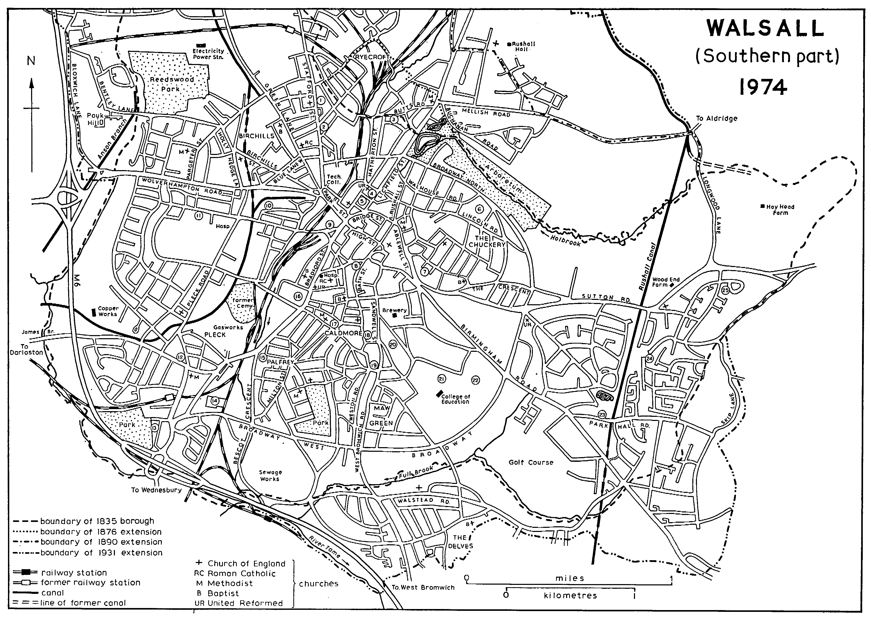
1. Former Primitive Methodist chapel. 2. Former Wesley Centenary chapel. 3. Site of St. Mark's Church. 4. Central Library. 5. Council House and Town Hall. 6. Lincoln electrical works. 7. Crump's Alms-houses. 8. Harper's Alms-houses. 9. Former Municipal Institute. 10. Aluminium works. 11. Site of manor-house 12. Nanak Sar Sikh temple, formerly a Primitive Methodist chapel. 13. Site of Bescot Hall. 14. Fellows Park football ground. 15. Site of New Mills. 16. Henry Boys Alms-houses. 17. White Hart inn. 18. Marsh's Almshouses. 19. Guru Nanak Sikh temple. 20. Former windmill. 21. Cricket ground. 22. Site of Gorway House. 23. Site of Park Hall. 24. Site of Gillity Greaves. 25. Site of Daffodil Farm.
The area to the north-east of the town centre was developed in the 19th century mainly by John Walhouse and his successors the barons Hatherton, who owned most of the land. (fn. 52) Indeed Peter Potter, while developing the Bradford Street area for Lord Bradford, saw Walhouse as a competitor for 'the benefit of the increase of this town'. (fn. 53) The district is in the main residential, with houses ranging from large villas to working-class cottages. Much of the smaller property, however, has been replaced by council houses and flats, while many of the villas have been turned into offices.
The chief building before the 19th century was Reynold's Hall, near the present Arboretum Road. It was the house on which the Walhouse estate centred until John Walhouse demolished it in the late 18th century as limestone working developed in the area. The home farm survived until 1897. (fn. 54) The side road now called Intown Row existed by the later 17th century as part of a way leading from Rushall Street to Park Street. That way was presumably one leading from Rushall Street to Walsall field mentioned in the 15th century; it seems to have crossed the Holbrook by a stone bridge by the later 16th century. (fn. 55) Holtshill Lane, running up the hill to the east of Rushall Street, existed as Holt Lane in 1367. (fn. 56) The Holtshill area occurs as the Holt in the 14th century; the name Holtshill was in use by 1440, and Holtshill Top occurs in 1512. (fn. 57)
Lichfield Street was built from Bridge Street under an Act of 1830 and replaced Rushall Street and Dovegrove Street (renamed Ward Street c. 1864 in honour of Alderman William Ward) as the main road to Rushall and Lichfield. (fn. 58) In 1831 John Walhouse began to grant building-leases in Lichfield Street, (fn. 59) and by the 1850s the resulting villas had made it 'a street of remarkable beauty and not only the most picturesque but the most fashionable portion of the town'. (fn. 60) By the 1880s villas had been built along it to a point beyond Mellish Road and by the beginning of the 20th century nearly as far as the borough boundary. (fn. 61) A library was opened at the southern end in 1831. The Council House to the north was built on the site of Teddesley House in 1902-5; the central library further north on the other side of the new Tower Street was opened in 1906. Public baths had been opened behind the library site in 1896. (fn. 62)
On the western side of Lichfield Street Hatherton Place, now the eastern end of Hatherton Road, existed by 1832; it was originally known as Littleton Place, a name in use by 1834 when a building-lease was granted there. Hatherton Street had been built north from it by 1836, and part of Littleton Road, now Littleton Street West, existed by then; Lower Forster Street was being planned. It had been built by 1843, and Littleton Road had then been extended east to Lichfield Street. Brook, later Albert, Street existed by 1839. (fn. 63) In 1855 Hatherton Place was described as a pleasant little street with particularly beautiful houses, while the Littleton Street area was one 'where streets and habitations are daily springing up on every side'. (fn. 64) Upper Forster Street was being planned in 1844, and by 1857 it was linked by Warwick Street with Teddesley Street, both of which were built up in the later 1850s and earlier 1860s; (fn. 65) the area consists mainly of terraced houses. Darwall Street was built in the late 1870s by the trustees of C. F. Darwall, and Leicester Street linking it with Bridge Street dates from the same time. (fn. 66) Hatherton Road running from Lichfield Street to St. Paul's Road dates from c. 1933. (fn. 67) By 1883 several factories, mainly tanneries and sawmills, had been built between Hatherton Street and Ford Brook. (fn. 68) Hatherton, Teddesley, and Upper Forster Streets run into the area known as the Butts, which was added to Walsall from Rushall in 1876 but had been part of the Walsall improvement commissioners' district from 1848. (fn. 69) Lord Hatherton granted leases in the area from 1840, and a working-class district grew up. (fn. 70) A school was opened in 1868 and a mission chapel in 1871. (fn. 71) Two new streets, William and Cecil Streets, were laid out over Lord Hatherton's land in the later 1870s. (fn. 72) The area to the north around Westbourne Road, a street existing by 1880, dates mainly from the late 19th and early 20th centuries; it consists largely of better-class terraces built on land belonging to Lord Hatherton and William Guy, a retired currier. (fn. 73) In 1974 much of the district was being redeveloped by the council, notably the area between Littleton Street East and Butts Road; several blocks of multi-storey flats had been built in the 1960s. (fn. 74)
To the east of Lichfield Street is a district mainly of villas and better-class terraces. Walhouse Street was built as far as Lower Rushall Street at the same time as Lichfield Street; the first lease was granted in 1831. (fn. 75) Persehouse Street, the southern end of which existed by the early 19th century, was laid out in the early 1850s. (fn. 76) Walhouse Street had been extended to meet it by 1856 and was renamed Lower and Upper Walhouse Streets. (fn. 77) A buildinglease was granted in Holtshill Lane in 1828 and others from the 1840s; the 1860s, however, were the time when extensive building of terraces was carried out there, some of them with long front gardens. (fn. 78) The west end of Denmark Road, now part of Broadway North, existed as Littleton Place by 1857; it was extended c. 1865 and renamed in honour of the Princess of Wales. (fn. 79) Persehouse Street was extended north of Denmark Road in 1867 to accommodate 'buildings of good style and some pretension'; a building-lease was granted to Henry Farrington, who himself lived in one of the villas, Hatherton Hill House (now St. Patrick's Convent). (fn. 80) The extension is now called Arboretum Road. Rowley and Charlotte Streets were built in the later 1860s, being named after Charlotte Rowley, who married Lord Hatherton's eldest son in 1867; Upper Walhouse Street was extended to Charlotte Street at the same time. (fn. 81) St. George's Church was built at the corner of Persehouse and Upper Walhouse Streets in 1873-5, and many 'superior' houses were being built round it in 1874. (fn. 82) In the late 1890s Denmark Road was extended east, Reynold's Hall Farm being demolished to make way for it in 1897; the extension was named Foden Road after E. A. Foden, who as Lord Hatherton's agent was involved in the development of the area from 1867. (fn. 83) Both Denmark and Foden Roads became part of the ring road completed in 1929 and had been renamed Broadway North by 1934. (fn. 84) In 1925 Lower and Upper Walhouse Streets were renamed Walhouse Road, which in the years immediately following was extended to the ring road; Calder Avenue was built across the extension. (fn. 85) The first stage of the flats called St. George's Place in Persehouse Street was completed in 1955; houses have been built opposite on the site of St. George's Church, demolished in the mid 1960s. (fn. 86)
The area to the north which is now occupied by the Arboretum was partly in Rushall until 1876. Limestone was being quarried there by the late 18th century. Operations had ceased by the earlier 1840s, leaving two flooded pits, the larger of which was known as Hatherton Lake by 1845. Victoria Terrace to the north was built as Hatherton Lake Villas by Henry Farrington in the earlier 1850s. (fn. 87) In 1858 it was suggested that a public park should be made in the area, (fn. 88) and from 1868 Lord Hatherton's agent was supporting the idea as a means of improving the locality and encouraging development. (fn. 89) The Walsall Arboretum and Lake Co. Ltd. was formed in 1870, and in 1873 it took a lease from Lord Hatherton and Sir George Mellish (fn. 90) of the two lakes and 7 a.; the land was to be laid out as 'an arboretum or pleasure grounds and gardens'. The park was opened in 1874, with lodges and boundary wall designed by Robert Griffiths of Stafford, the county surveyor. (fn. 91) It failed to pay its way, and in 1877 it was taken over by a committee, which made it a commercial success with such attractions as an aquatic fête featuring Captain Matthew Webb, the Channel swimmer, a steam launch, and a band of Zulu warriors. In 1881 the borough council, after much pressure, took a three-year lease of the Arboretum and opened it as a public park; it bought the freehold in 1884. The Arboretum was extended south-eastwards several times between 1891 and 1952 and now covers 145 a., of which 69 a. are playing-fields and over 40 a. free-play areas.
The district north-east of the Arboretum, which was part of Rushall until 1890, is a middle-class residential area with open country around Calderfields Farm. (fn. 92) The road running from the Butts to Aldridge is an old way; in 1869 the western end was straightened across the Moss Close area as Mellish Road, which takes its name from the Mellish family, owners of the estate centring on Rushall Hall. (fn. 93) Buchanan Road existed by 1874 and was named after the family into which Frances Mellish had married in 1839. (fn. 94) The area contains houses of the late 19th and earlier 20th centuries, but the most extensive development has been since the Second World War, some of it over the site of earlier industrial working.
Of the streets on the east side of Ablewell Street Bott Lane existed by 1501. (fn. 95) A lane called Brygens Lane leading from Ablewell Street to land called Paddoke was mentioned in 1567 and was presumably Paddock Lane, which existed by 1782. (fn. 96) Lime Pit Bank (now Bank Street) was an area of metalworking by 1767. (fn. 97) What is now Pool Street existed by 1782. (fn. 98) An early lane ran along what are now Balls Street, Balls Hill, and Dog Kennel Lane. (fn. 99) The western end of Tantarra Street was built c. 1830, taking its name from the plot of land which it crossed. (fn. 100) Union Street, linking Paddock Lane and Holtshill Lane, existed by the mid 1840s and was so named by 1855. (fn. 101) The systematic building up of the area, with workshops, factories, and houses, began in the 1850s, Lord Bradford and Lord Hatherton both granting leases. (fn. 102) Tantarra Street had been extended eastwards by 1857 and was continued to Dark Lane in the early 1870s. (fn. 103) Warewell Street apparently dates from the later 1850s. (fn. 104) Pasture in Bott Lane was offered for sale in 1860 as building land for houses and factories 'in this extending part of the town'. (fn. 105) Box Street was built in the late 1860s. (fn. 106) Selborne, Eldon, Burleigh, and Walsingham Streets were laid out by John Farrington Crump, a solicitor, on land which he bought from Lord Hatherton in 1872. (fn. 107) Bernard Street was named in 1874, (fn. 108) and Lime and Richmond Streets apparently date from about the same time. (fn. 109) Paddock Lane and Tantarra Street were cut in two in the 1960s when five multi-storey blocks of council flats were built across them. (fn. 110) The main industries of the area in 1974 were metal- and leather-working.
The streets in the mainly residential area to the east known as the Chuckery date largely from the turn of the 19th century. The name may be derived from Churchgreave, the name of one of the common fields; the boundaries of the field seem to have followed the line of several of the present streets in the area. (fn. 111) A track ran from Holtshill Lane to the Sutton road by 1763; called Dark Lane until the 20th century, it followed more or less the line of the present Lincoln Road (named after the Lincoln electrical works opened there in the 1920s) and Prince's Avenue. (fn. 112) Lord Hatherton granted building-leases in the northern part in 1869 and 1870. (fn. 113) The main development in the area, however, was on land belonging to Lord Bradford, who granted leases in Lumley Road and Kinnerley, Florence, Moncrieffe, and Tong Streets between 1898 and 1903. The southern end of Beacon Street too dates from about that time. (fn. 114) Although Sutton Crescent (that part of the street now called the Crescent west of Broadway North) existed by the 1870s, houses were not built there until the early 20th century. (fn. 115) Some of the large houses to the south in Prince's Avenue are of the later 19th century, but those to the north of the Crescent, built on Lord Bradford's land, date mainly from the early 20th century. (fn. 116) The residential area was further extended between the World Wars. In the same period the Sutton road, which at least until the building of Sutton Crescent ran along Prince's Avenue and the Crescent, was realigned to run south of the Crescent. (fn. 117)
The district to the east contains an area of early settlement at Wood End, which straddled the Sutton road near the parish boundary and was inhabited by 1317. (fn. 118) There were around 30 recipients of Mollesley's Dole in the earlier 17th century. (fn. 119) The main road there was known as Wood End Lane in the 18th century, and at the point where it crossed the boundary the Epistle and Gospel were read during perambulations of the parish and manor. (fn. 120) Skip Lane, which runs from Great Barr in Aldridge to the Sutton road and follows the boundary for a short distance, occurs as Hogfield Lane in 1479. (fn. 121) Longwood Lane running north to Aldridge Road may be the lane leading to Caldwell Wood mentioned in 1630. (fn. 122) There was limestone quarrying at Wood End by the later Middle Ages and at Hay Head to the north by the late 16th century. (fn. 123) Both sides of Sutton Road are lined with privately built houses mainly of the period between the two World Wars; the road was realigned at Wood End Farm as part of its general improvement at that time. The area to the north of the road is open country. The area to the south is also occupied by middle-class housing; a few of the roads had been laid out by 1938, but most of them date from the 1950s and 1960s. (fn. 124)
The area along Birmingham Road in the southeast of the borough has developed as a middle-class suburb. Until the late 18th century the road to Birmingham, known as Peakhouse Lane, followed a winding course along the present Jesson Road and through Five Ways along Park Hall and Lonsdale Roads, but it was straightened to its present course apparently c. 1788. (fn. 125) In the earlier 17th century Five Ways, then called Five Lanes End, had about 20 recipients of Mollesley's Dole. (fn. 126) Five Lane End farm occurs in 1696 and was also known as Sergeant's Coppice farm in the earlier 19th century. (fn. 127) By 1763 there were a few houses along and near the Birmingham road, including what was later called Gorway Farm. (fn. 128) The northern end of the road, known as King Street in the earlier 19th century, contained commercial premises by 1813, and although it was outside the borough it was populous enough to be included in the improvement commissioners' district in 1824. (fn. 129) Spring Hill House, in the part of Jesson Road now occupied by St. Mary's Roman Catholic school, existed by 1813 as Springfield, the home of Richard Jesson, an attorney. (fn. 130) Gorway House was built in the later 1820s by Peter Potter, Lord Bradford's agent. (fn. 131) The Terrace in Dandy's Walk off King Street (now part of the Blue Coat School) had been built by John Forster by 1834. (fn. 132) By then in fact the area was noted for its 'several neat villas'. (fn. 133)
In the 1860s a suburb of 'villas and terraces of villettes' developed around the northern part of the Birmingham road. It was considered by one writer to be the most attractive part of Walsall: 'above the lamplights and level pavement the branching trees spread their network of interchanging leaves after the manner of Parisian boulevards . . . and the denizens have had to consult horticultural encyclopaedias to find euphonious titles for their trim villas.' (fn. 134) Belvidere Road existed by 1860 when Lord Bradford began to grant building-leases there. (fn. 135) Lysways Street was described as a new road in 1866; it consists largely of better-class terraces and pairs of houses built by 1885. Emery Street, linking it with Lodge Street (now Sandymount Road) and containing smaller terraces, existed by 1885, but only the northern end had then been built up. (fn. 136) Highgate Brewery at the west end of Sandymount Road was opened in 1898. (fn. 137) The Highgate area further south contains many later-19th-century villas and some smaller houses of that period and the early 20th century. Highgate House was built in the mid 1850s by F. B. Oerton, a saddlers' ironmonger who had lived in a house by his works in Bath Street; he was mayor in 1854-5. Gorway Road linking Highgate Road with Birmingham Road dates from the late 19th century. (fn. 138) Park Hall was built in 1863 and from c. 1897 was the home of W. J. (later Sir William) Pearman Smith (d. 1939), a Walsall solicitor who was mayor 1899-1902. (fn. 139) By the mid 1880s roads had been laid out west of Birmingham Road at Sargent's Hill and on either side of the south-eastern boundary; the latter at least seem to have been connected with a private scheme which was promoted in 1871-2 by Samuel Wilkinson, the town clerk, for developing the 60-acre Park Lodge estate. In fact most of the houses there and at Sargent's Hill were not built until the years between the two World Wars and after. (fn. 140) The course belonging to Walsall Golf Club to the west of Sargent's Hill was opened in 1906. (fn. 141) A municipal golf-course was opened in the Gorway area on the north side of Broadway in 1930; it was ploughed up during the Second World War and is now part of the site of the West Midlands College of Educa tion, opened in 1963. (fn. 142) The college also took over Gorway House and 7 a. in 1966 and built college extensions there in 1970-2 after demolishing the house. (fn. 143) The building of houses and flats has continued throughout the area, some on the sites of demolished villas. Broadway, built in the 1920s, is lined with houses of the period between the two World Wars. (fn. 144) In the south-east of the area there are many houses built privately since the Second World War over Brookhouse farm and much of the Park Hall estate. (fn. 145) Park Hall itself was demolished in the 1950s and a primary school opened on the site in 1970. (fn. 146)
Maw Green around what is now the junction of West Bromwich Road, Delves Road, and Highgate Road was an inhabited area by the 18th century. (fn. 147) Maw Green Farm to the south-east, which existed by the early 19th century, may have been there by 1747. (fn. 148) Collins Farm to the south at what is now the junction of West Bromwich Road and Tame Street occurs as the property of John Persehouse in 1608. (fn. 149) It may be identifiable with Cannock Farm at Caldmore which was held of the Crown by the Collins family in the earlier 1590s. (fn. 150) Folly House in Folly House Lane to the east of Maw Green existed by the early 19th century and was described in 1855 as an ancient habitation; later known as Rock's Cottage, it was demolished in 1931. (fn. 151) There was settlement by the 18th century at Fullbrook where the West Bromwich road crosses the former southern boundary. (fn. 152) It was not until the late 1890s that the Maw Green area began to be built over. Terraces were then built on Lord Bradford's land at the northern end of West Bromwich Road and in the new Weston Road; more were built in the early 20th century. (fn. 153) Council houses were built over much of the area in the later 1920s; Collins Farm was demolished in 1928 and Maw Green Farm in the 1930s. Broadway was built across the area in the 1920s, and privately owned houses had been built along it by 1938. Houses were built both by the council and privately along West Bromwich Road south of Broadway in the same period. (fn. 154)
On either side of West Bromwich Road south of the old boundary is the portion of the Delves that was transferred from Wednesbury in 1931. The purpose of the transfer was to provide Walsall with land for houses, and most of the housing, both council and privately built, dates from the 1930s. (fn. 155) From the 1930s factories were built in the west of the area. (fn. 156) Houses were built south of Brockhurst Crescent c. 1970, and the M6 motorway, opened in 1970, (fn. 157) crosses that area. In the centre of the Delves is Delves Green, a 19-acre open space maintained by the corporation. (fn. 158)
The Caldmore area lies between the old roads to West Bromwich and Wednesbury. The West Bromwich road (fn. 159) ran along New Street, the southern part of which was formerly called Fieldgate, (fn. 160) and Sandwell Street, formerly called Windmill. (fn. 161) The Wednesbury road ran along Dudley Street and Vicarage Place until the opening of Bradford Street in 1831. (fn. 162) Though mainly common arable, (fn. 163) Caldmore was an inhabited area by the early 14th century. Thomas Faukes of Caldmore occurs in 1307, (fn. 164) and in 1317 a house there formerly held by William the reeve was in the hands of Richard Paynel. (fn. 165) The vicarage house of St. Matthew's stood to the south of Vicarage Place until the 19th century, probably occupying the same site from the Middle Ages. (fn. 166)
The main settlement was round Caldmore Green, where several old ways meet: Caldmore Road (formerly Caldmore Lane), Corporation Street (formerly Coal Pit Lane), West Bromwich Street, and Watery Lane. (fn. 167) Caldmore Lane ran into Bath Street along what is now Little Caldmore, and those roads presumably formed the highway from Walsall to Caldmore, mentioned in 1693. (fn. 168) Bath Street occurs as Prospect Row in the early 19th century and was renamed when the baths in Dudley Street were opened in 1850. (fn. 169) A house called Shur Hall stood at the southern end of Spout Lane by the early 19th century; by 1974 it was used as commercial premises. (fn. 170) Little London at the southern end of Sandwell Street was an inhabited area by the later 17th century. (fn. 171) There were 102 recipients of Mollesley's Dole in Caldmore in 1619 and 219 in 1661; the second figure, however, and probably the first also, included Pleck. (fn. 172)
There was development in patches throughout the area by the 18th century. At Little London there was spur-making by the earlier 18th century. (fn. 173) By the 1760s an industrial suburb of metal-workers had developed along Fieldgate and in Windmill Street between Sandwell and Bath Streets, and there were also metal-workers at Caldmore itself. Doveridge along West Bromwich Street south-east of Caldmore included four metal-workers in 1770 as well as two farmers. (fn. 174) The Roman Catholic church of St. Mary was opened in 1827 on St. Mary's Mount above the vicarage, (fn. 175) and near by St. Mary's Row was built in the later 1840s, 'a neat row' consisting of the works and houses of Messrs. Harvey & Buffery, platers and harness-makers. (fn. 176) The Windmill area was further developed in the 1830s and early 1840s when Lord Bradford granted building-leases in Orlando Street and the north end of Sandwell Street. He granted further leases in the same area and in Cemetery Road (now Barleyfields Row) in the 1850s. (fn. 177) Newhall Street existed by 1843 and was so named by 1851. (fn. 178) The Walsall Freehold Land Society, established in 1851, bought nearly 3 a. for development in Caldmore Lane in 1855. (fn. 179) The streets on either side of Corporation Street were laid out in the 1860s and 1870s. (fn. 180) Lord Bradford granted several building-leases on the west side of Wednesbury Road in the 1870s, but the houses in that road date largely from the later years of the century. (fn. 181) An Anglican mission was established at Caldmore in 1866 and a school opened in 1867; St. Michael's Church in Bath Road was opened in 1871, and St. Michael Street (called Stratford Street until 1925) dates from about then. (fn. 182) Hope Street to the north was built c. 1876. (fn. 183) Oxford Street to the south of St. Michael's was renamed Carless Street in 1923 in memory of Seaman J. H. Carless, V.C., a native of Walsall who was killed in action in 1917. (fn. 184) The glebe land in the north of the area was built over in the 1880s and 1890s when Vicarage Street and Glebe Street were laid out along two lanes called Vicarage Walk and were built up with terraces; Vicarage Terrace, however, in the southern part of Vicarage Street had been built in 1868 and the near-by Prospect House in 1872. (fn. 185) Vicarage Street was extended to Bradford Street via Cross Street in the mid 1930s and the whole became part of Caldmore Road. (fn. 186) Bath Street was extended south across Peg's Piece as Bath Road c. 1885 to join the street now called Little London, and the new road was built up during the next few years. (fn. 187) Arundel, Windsor, and Cambridge Streets on the south side of West Bromwich Street were laid out by 1875, but most of the terraces date from the late 1880s and the 1890s; Thorpe Road too was added then. (fn. 188)
There has been some redevelopment of Caldmore since the 1950s. The council houses and flats in Orlando Street replaced 100 slum properties; work began in the late 1950s and the first new dwelling was let in 1961. The multi-storey flats in Little London were first occupied in 1967. (fn. 189) An area in Spout Lane was cleared in 1962, but no rebuilding took place and the site became infested with rats and mice. (fn. 190) As a result the Caldmore Residents Action Group was formed in 1970, and in 1971 the council began rebuilding the area with flats and houses. The action group established a housing association in 1972, with offices and an aid centre in a converted shop on Caldmore Green. The council declared part of Caldmore a general improvement area in 1971, the first in Walsall. In 1973 several of the streets south from West Bromwich Street were planted with shrubs and plants. Some restrictions have also been placed on motor traffic. The Caldmore district (including much of Palfrey to the south) remains a working-class community; in 1974, however, 60 per cent of the population were owner-occupiers. Thirty per cent of the community were immigrants and their families, mainly of Asiatic origin.
Palfrey is continuous with Caldmore and has its centre upon Milton Street. Before the later 19th century, however, there was little settlement in the area. Palfrey Green occurs in 1386 as demesne pasture and lay at the southern end of what is now Lord Street. (fn. 191) Other early lanes included one mentioned in 1587 running from Palfrey Green to Friar Park smithy in West Bromwich (fn. 192) and one which followed the lower part of the present Alexandra Road and part of the present Weston Street to the West Bromwich road in the Redhouse Farm area. (fn. 193) Milton Street is part of an early way running from Caldmore (along Watery Lane) and continuing to Bescot (along Wallows Lane). (fn. 194) The northern end of Milton Street ran by the pool of the early-17th-century New Mills and was formerly called Stank Lane. (fn. 195) There was evidently ironworking near Palfrey Green in the later Middle Ages. (fn. 196) In 1770 an awl-blade maker and a spurmaker were recorded at Whitehall between Palfrey and Caldmore. (fn. 197) This suggests the existence by then of the house called White Hall which still stood in 1843 at what is now the junction of Dale Street and Alexandra Road. Old cottages there were demolished in 1928. (fn. 198) Palfrey Farm in the area between Dale and King Streets existed by the early 19th century. (fn. 199)
Development began when the Walsall Freehold Land Society acquired a 22-acre estate at Palfrey in 1852. The land was divided into 145 lots and distributed among 78 people. Building had started by 1853. (fn. 200) This was the beginning of Cobden Street and its side streets, Queen Street (renamed Queen Mary Street in the later 1920s), King Street, and the west end of Dale Street, all of which contained houses by 1861. Whitehall Road, cut in the later 1860s, was built up by the mid 1870s, and Tennyson Street (now the east end of Dale Street), Alexandra Street (the north end of Alexandra Road), and Villiers Street existed by then. There were also buildings on the corner of Milton and Lord Streets. (fn. 201) The north end of Sun Street was described as a new street in 1881, and schools were built there in 1884; it had been extended to Dale Street by 1893. (fn. 202) Palfrey Park was opened in 1886 on 8 a. to the south of Dale Street, the two ends of which were presumably linked about that time; the park was extended to its present 16 a. c. 1935. (fn. 203) From the mid 1880s Lord Bradford was developing the area to the north of New Mills between Milton Street and Wednesbury Road. Several building-leases were granted in Stank Lane and Milton Street between 1885 and 1888. Earl Street and Countess Street were laid out in the early 1890s and building-leases granted in 1893, 1894, and 1899. (fn. 204) The streets to the south date from about the same time, and much of the building in Lord Street is of the late 19th and early 20th centuries. (fn. 205)
Building spread southwards to the borough boundary between the World Wars, with both council and privately built estates. Alexandra Street was extended south to Lord Street along Love Lane as part of the Palfrey council estate and renamed Alexandra Road. Broadway West was built across the southern area in the 1920s and is lined with privately built houses of the inter-war years. Bescot Crescent, dating from the same period, contains much light industry. (fn. 206) Many immigrants have settled in the old part of Palfrey. The Whitehall Road area has been included in the Caldmore improvement scheme. Demolition of several of the terraces was in progress in 1974, and there had been some rebuilding on cleared sites.
The Pleck, a name meaning a small plot of ground, occurs as a small area of waste in 1576 and 1617. (fn. 207) In the later 18th century at least it lay at the junction of Darlaston Road (then called Pleck Lane) and Old Pleck Road. (fn. 208) The oldest settlement in the vicinity was Bescot. The name suggests Saxon occupation ('Beorhtmund's cottage'), (fn. 209) and the place is mentioned in Domesday Book as a waste carucate. (fn. 210) It occurs as an inhabited area in the earlier 13th century (fn. 211) and contained a manor-house by the early fourteenth. (fn. 212) The area to the north between Darlaston Road, Pleck Road (formerly Park Lane), and Wolverhampton Road was occupied in the Middle Ages by the park and Walsall manorhouse. (fn. 213) The Pleck itself was an inhabited area by the 17th century. (fn. 214) In 1619 there were 16 recipients of Mollesley's Dole at Bescot and 4 at the Park. (fn. 215) The area to the north-east between Pleck Road, Wednesbury Road, and Bradford Street remained undeveloped until the 19th century, except for the race-course of the 1770s. (fn. 216) Several cottages had been built over the Pleck by 1763, when it was crossed by what are now Narrow Lane and Wellington Street (formerly Horseshoes Lane). There were also a few houses to the east along Wednesbury Road and Wallows Lane and to the west along Darlaston Road, including one on the boundary at James Bridge. There were several houses in the area of the former park; they included one with an 84-acre holding attached, known as Park House and the forerunner of what was called Parks Farm in the early 19th century. Bescot Farm at the end of what is now Slater's Lane also existed by the later 18th century. (fn. 217) The Walsall Canal was built through the district in the later 1790s. (fn. 218)
Extensive growth came in the later 19th century, but there had been some building earlier in the century. At Pleck itself a National school was opened in 1825 and a Wesleyan meeting was started c. 1827. (fn. 219) Chapel, Regent, and Oxford Streets had been laid out by 1843 in the angle of Old Pleck and Wednesbury Roads. Chapel Street took its name from the Wesleyan chapel opened there in 1840; it was renamed St. Quentin Street to commemorate the storming of the Hindenburg Line at the St. Quentin Canal in 1918, an operation in which Walsall men took part. Regent Street was renamed Caledon Street after the ship in which J. H. Carless, V.C., served. (fn. 220) In the area south of Wolverhampton Street there was limestone working by 1813. (fn. 221) It was there too that Bridgeman Street was built from Bradford Street to Pleck Road by Lord Bradford c. 1836. Two houses were being built near the bridge over Walsall Brook early in 1838, and Bridgeman Place near by existed then; as Bridgeman Terrace it was described in 1855 as 'a handsome row of fashionable houses with stucco fronts', one of them the home of Charles (later Sir Charles) Forster, M.P. for Walsall. (fn. 222) By 1843 Navigation Street had been built north from Bridgeman Street, and a road (now the eastern end of Moat Road) continued Bridgeman Street over Pleck Road beside the union workhouse of 1838. (fn. 223) There were brickworks at James Bridge and in the Park area by 1834, and James Bridge Colliery was working by 1843. (fn. 224)
The extension of mining and the building of ironworks from c. 1850 led to a great increase in the population of the Pleck area, said to be over 2,500 in 1858 when St. John's Church was opened in Pleck Road. (fn. 225) Most of the growth was east of Pleck Road where from the 1850s factories and streets of workers' cottages were built over Lord Bradford's land. The railway had been opened through that part in 1847, with a station first in Bridgeman Place and from 1849 in the new Station Street. (fn. 226) In the 1850s building-leases were granted not only in Bridgeman Street, Navigation Street, and Pleck Road but also in the new Rollingmill, Long (at first George), Queen (at first Earl), Frederick, Augustus, Henry, Weston, Brineton, and Wharf Streets. A cemetery was opened at the southern end of Queen Street in 1857. Development continued throughout the area in the 1860s and 1870s, and Short, Brook, and Brockhurst Streets and part of Charles Street were built. (fn. 227) Corporation Street West, continuing Queen Street to Wednesbury Road, dates from c. 1880. (fn. 228) By the 1880s there were works along both sides of the canal, mainly ironworks and tube works; Henry Boys's Waterloo Colliery and Brickworks had been opened by 1868, and the corporation's gasworks dates from 1877. (fn. 229) By the 1880s too development was extending eastwards over the racecourse. Midland Road had been laid out by 1885, (fn. 230) and Tasker Street, which occurs as Tasker's Lane from 1587, was being built up by 1889. (fn. 231) Meadow Street dates from c. 1892. (fn. 232) In 1904 it was stated that upwards of 3,000 people lived close to the mission church in Rollingmill Street. (fn. 233) By 1974 the area was mainly industrial, and many of the factories were new. Some houses still stood in Queen Street, but few were occupied. (fn. 234)
The rest of the Pleck district also developed from the later 19th century, mainly as a residential area. (fn. 235) There was then, however, extensive coalmining between Wolverhampton and Darlaston Roads and at Bescot. The last colliery, James Bridge, was abandoned in 1901. Brick-making apparently ceased c. 1897, but sand and gravel were still worked on both sides of Darlaston Road in 1916. James Bridge remains an industrial area.
In Pleck itself Lord Bradford granted buildingleases round St. John's Church in the late 1850s, and terraces were built along the west side of Pleck Road, also on the Bradford estate, shortly afterwards and in the early 1880s. (fn. 236) Houses were built at the Pleck end of Darlaston Road in 1867 and 1871. (fn. 237) Several villas had been built in Bescot Road by 1875, and a station was opened there in 1881; Slaney Road, though largely occupied by houses and flats built privately after the Second World War, dates from the late 19th century. (fn. 238) The development around the Pleck end of Wednesbury Road, now the shopping centre of the area, took place in the 1890s and the early 20th century. (fn. 239) Prince Street was laid out c. 1893. (fn. 240) The southern end of Scarborough Road and the terraces along the south side of Darlaston Road date from c. 1900. (fn. 241) The streets between Darlaston Road and Slater's Lane date mainly from the early 20th century. (fn. 242) Some terraces were built on Lord Bradford's land at the north end of Pleck Road in the later 1850s, and Moat Street (now Road) existed by 1860. Most houses in that area, however, date from the end of the century. Checketts Street was built by Walter Checketts on land leased from Lord Bradford in 1891 and 1893, and Forrester Street was being built up throughout the 1890s. The east end of Ida Road dates from the late 19th and early 20th centuries. (fn. 243)
In the 20th century much of the area has been used for council housing. The estate around Ida and Alumwell Roads dates from the later 1920s and the 1930s, and it was continued west to Primley Avenue from the later 1940s. (fn. 244) There is also an estate at the end of Slater's Lane, built both before and after the Second World War. Another, which includes several multi-storey blocks of flats, was laid out in the cleared Oxford Street area in the later 1960s. (fn. 245) Rebuilding in the Wolverhampton Road area was still in progress in 1974. The streets of privately built houses on either side of Bescot Road date from the years between the two World Wars; those on the west were laid out over part of the grounds of Bescot Hall after its demolition in 1929-30. (fn. 246) The 28-acre Pleck Park covers more of the grounds; the first portion was opened as a war-memorial playingfield in 1926, and the corporation bought more land in 1938. (fn. 247) The M6 motorway was opened through the west of the area as far as Bescot in 1968. (fn. 248)
Birchills occurs as an area of wood and waste in the earlier 14th century. (fn. 249) About 1540 40 trees were felled there, (fn. 250) and Birchills was described as 30 a. of common waste in surveys of 1576 and 1617. (fn. 251) Deadman's Lane, renamed Hospital Street c. 1872, existed by 1545. (fn. 252) Birchills Lane, running between Walsall and Birchills and also known as Green Lane by 1763, is mentioned in 1559, and there was a cottage beside it in 1587. (fn. 253) Coal was mined at Birchills by the early 17th century, (fn. 254) and there were about 20 recipients of Mollesley's Dole in the middle of the century. (fn. 255) The lane leading from Birchills to Bentley Hay, mentioned in 1729, (fn. 256) was presumably Bentley Lane, which existed by 1763. The roads now known as Birchills Street, Hollyhedge Lane, and Old Birchills also existed in 1763, and there was then settlement along all the roads in the area, including the present Wolverhampton Road. (fn. 257) Birchills Hall east of Green Lane apparently existed by the late 18th century; although part of it survived into the 20th century, by 1850 it was surrounded by pits and ironworks and much of it had then recently been demolished. (fn. 258)
By 1770 there were many metal-workers at Birchills. (fn. 259) The Wyrley and Essington Canal was built through the district at the end of the 18th century, and Birchills was the principal area of coalmining in Walsall in the earlier 19th century. There was also iron-working and limestone mining. (fn. 260) A large population had grown up by the 1850s, (fn. 261) concentrated north of Blue Lane West. Burrowes Street existed by 1851. Regent Street and the eastern end of Farringdon Street were being built up in the 1850s on Lord Bradford's land, and the block of streets between Birchills Street and Wolverhampton Road dates from then. A Primitive Methodist centre was opened in 1850 in a schoolroom in Old Birchills, and a National school and Anglican mission were started in a building in Hollyhedge Lane in 1855. Building-leases on the Bradford estate in that area were granted in 1857, the later 1860s, and 1873, and also on the east side of Green Lane between Upper and Lower Union Streets (now Croft and Mary Streets) in the mid 1850s and mid 1860s. (fn. 262) Newland Street off Blue Lane West was built to provide new working-class houses in conjunction with the corporation's clearance of the adjoining Townend Bank area in the later 1870s. (fn. 263)
Birchills was a poor locality. In arguing the case for converting the derelict mining ground at Reedswood north of Bentley Lane into a park in 1879, the vicar of St. Peter's, Stafford Street, spoke of the pale and haggard looks of the inhabitants and the 'shoals of little ones at the entrance of court after court, making mud pies in the gutters or prying down the gullies of the common sewers in the streets'. (fn. 264) In 1886 the Anglican mission district was described as 'the poorest part of the poorest parish in Walsall'; out of a population of 5,000 or more there were only five households that kept a servant. (fn. 265) Although there was strong opposition in the town to the idea of reclaiming the ground at Reedswood, Lord Bradford conveyed 46 a. there to the corporation in 1885 for a nominal sum, and it was laid out as a park. (fn. 266)
By then building was spreading westwards. Raleigh Street was laid out c. 1882 by J. F. Crump and P. Pargeter, and Jessel Road and the north end of Pargeter Street were built about the same time. (fn. 267) The terraces at the east end of Bentley Lane were also begun, (fn. 268) and those in Dalkeith Street were built in the 1890s on land leased from Lord Bradford. (fn. 269) Neale Street was built in the early 1890s with the factory of Walsall Locks and Cart Gear Ltd. at the end of it. (fn. 270) Edward Street was built at the beginning of the 20th century. (fn. 271) More houses were built along Green Lane; Farringdon Street was extended and terraces were built there. The area around Lewis Street south of Hospital Street was built up c. 1892. (fn. 272) The houses at Bentley Moor, both council and privately built, date mostly from the years between the two World Wars. (fn. 273) The area lying north of Blue Lane includes maisonettes which were built in the earlier 1950s in Green Lane and multi-storey blocks of flats of the later 1950s in Burrowes Street. (fn. 274) The council was still rebuilding the rest of it in 1974. The part of Green Lane north of Hospital Street remains industrial, with engineering works, tubeworks, and a power station; in 1973 derelict land by the canal to the north of Stephenson Avenue was reclaimed and landscaped. (fn. 275)
The area on either side of Bentley Lane added to the borough in 1931 includes the Pouk Hill quarry. The dolerite deposit there was worked in the later 17th century and was largely exhausted by the 1880s. Some quarrying, however, continued until the Second World War. (fn. 276) By 1974 much of the neighbouring area was covered with new streets of privately built houses. It also contained cash-andcarry warehouses and some light industry.
The Townend Bank area in the north-west of the town is an inverted triangle, with its base on Blue Lane (so named by 1768), its sides along Wolverhampton Street (formerly Hampton Lane) and the southern end of Stafford Street (formerly Bloxwich Lane), and its apex at Townend Bank itself at the end of Park Street. Six newly built cottages on the waste at Townend were mentioned in 1617, and by 1763 there were many more cottages there, mainly towards the apex. There were also several cottages in the stretch of Bloxwich Lane north of the area. Metal-working was being carried on in the area by 1767. (fn. 277) The Walsall Canal, opened in 1799, ended at a wharf in Marsh Lane to the south-west of Townend Bank. (fn. 278) By the early 19th century buildings had appeared along the southern end of what was by then called Stafford Street, and there were also some at the western end of Blue Lane. (fn. 279) By the 1830s Wisemore to the east of Townend Bank was densely built up, and Blue Lane and Portland Street were becoming so. The streets immediately north on either side of Stafford Street were laid out c. 1840. (fn. 280) In one of them was a school dating from 1840, and in Stafford Street a Wesleyan chapel was opened in 1840 and St. Peter's Church in 1841. (fn. 281) Littleton Street West dates from about that time. (fn. 282) Lord Hatherton granted leases in Stafford Street in the later 1840s and early 1850s, and in 1855 it was stated that the Stafford Street area had grown remarkably in the previous five years. (fn. 283) In the Town end Bank part of Green Lane Lord Hatherton granted several building leases between 1849 and 1861. (fn. 284) Houses and commercial property still standing on the north side of Wolverhampton Street in 1974 probably date from the earlier 19th century. North Walsall station was opened in 1872. (fn. 285) Terraces were built northwards up both sides of Stafford Street and its continuation Bloxwich Road as far as the canal during the later 19th century. Northcote Street on the west side existed by the beginning of the 20th century and Gladstone Street linking it with Hospital Street by 1913. (fn. 286)
The western end of the town was described in 1867 as one 'of smoke and lime-kilns, gasworks, and Irish hordes', and in 1886 St. Peter's parish was said to be the poorest in Walsall. (fn. 287) Improvements were carried out at Townend Bank in the 1870s and earlier 1880s by Lord Hatherton and by the corporation. Margaret Street was built in the earlier 1870s. From 1876 the slums of Townend Bank were cleared. Marsh Street, consisting largely of commercial buildings, was laid out, and some of the properties remaining in 1974 are early examples of the use of moulded-brick ornament in Walsall. The south-eastern end of Shaw Street was also built as part of the improvements; it was continued northwestward to Blue Lane West along the line of an existing footpath in the early 20th century. Algernon Street was laid out partly on the line of an old tramway. (fn. 288) Slums were cleared in Wisemore and in Short Acre and Long Acre Streets west of Stafford Street in the 1930s. (fn. 289) Part of the Townend Bank area had been demolished by 1974, and there had been some rebuilding. Most of Wisemore was obliterated by the technical college, built in stages from 1949 to 1969. (fn. 290) By 1971 competition from the new shopping areas in the town centre and uncertainty about the course of the projected ring road had led to the decay of the shops in Stafford Street. (fn. 291)
Ryecroft to the east of Stafford Street was in Rushall parish until the 19th century when it became an extension of Walsall's urban area and was taken into the borough. (fn. 292) By 1834 it was noted for its sand quarries. (fn. 293) Proffitt Street, part of an old road, was known as Sandwell Street in the earlier 19th century; (fn. 294) the streets on the south side were being built up by the early 1840s. (fn. 295) A Primitive Methodist chapel was opened in North Street in 1845. (fn. 296) Marlow Street on the Walsall side of the boundary was built about the late 1850s. (fn. 297) Twenty-five houses were built in Long Ann Street c. 1855, nine of them fronting the street and the rest in 'a roomy court'. (fn. 298) The urban part of Ryecroft, having been included in the improvement commissioners' district in 1848, was added to the borough in 1876; a further part was added in 1890. (fn. 299) The cemetery in Coal Pool Lane was opened in 1894. (fn. 300) At the beginning of the 20th century a small estate was built on the north side of the railway on the site of the North Walsall Brickworks. (fn. 301) A council estate extended it northwards to Forest Lane in the later 1920s. Another council estate was built in the years between the two World Wars to the west off Coal Pool Lane, where the corporation bought Ryecroft farm in 1919. It also laid out 19 cottage holdings of 1 a. each on part of the farm for ex-servicemen. A council estate was built to the north of Proffitt Street, and in the 1930s the corporation rebuilt the slums in the old streets to the south. (fn. 302)
The name Bloxwich ('Blocc's dwelling') suggests Anglo-Saxon settlement, (fn. 303) but the place occurs in Domesday Book only as an area of woodland. (fn. 304) A distinction was drawn between Bloxwich and Great Bloxwich in 1300; (fn. 305) the first was presumably Little Bloxwich, a name in use in 1307. (fn. 306)
Great Bloxwich was the main settlement. A chapel of ease, the first in the parish, was built there apparently in the early 15th century. (fn. 307) The original centre was probably at the southern end of the present High Street in the Pinfold area, with building spreading north as encroachment on the waste. There was metal-working by the early 17th century, and probably earlier, and coal-mining c. 1597. (fn. 308) There were 419 recipients of Mollesley's Dole in 1619 and 611 in 1652. (fn. 309) By the later 18th century there was settlement not only in the Pinfold area but also around Chapel (later Elmore) Green where the church stands and round Short Heath to the north, approximately along the line of the present Wolverhampton Road, Sandbank, Bell Lane, Lichfield Road, and Park Road. There was also settlement at Wallington Heath further north round the junction of the Stafford road and Stoney Lane. (fn. 310) That was still the basic pattern in the early 1840s; there were also 11 new houses dating from c. 1840 along what is now Field Road. (fn. 311) New Street and Church Street date from 1850, (fn. 312) and the railway station to the south-west was opened in 1858. (fn. 313) By that time Bloxwich was becoming the chief coal mining area in the parish. (fn. 314) Reeves Street existed by 1861 and Harrison Street by 1870. (fn. 315) The streets between Elmore Green Road and New Street apparently date from the later 1870s. (fn. 316) Wolverhampton Street had been cut by 1879 when the first of several terraces was built there; it was renamed Parker Street in 1890. (fn. 317)
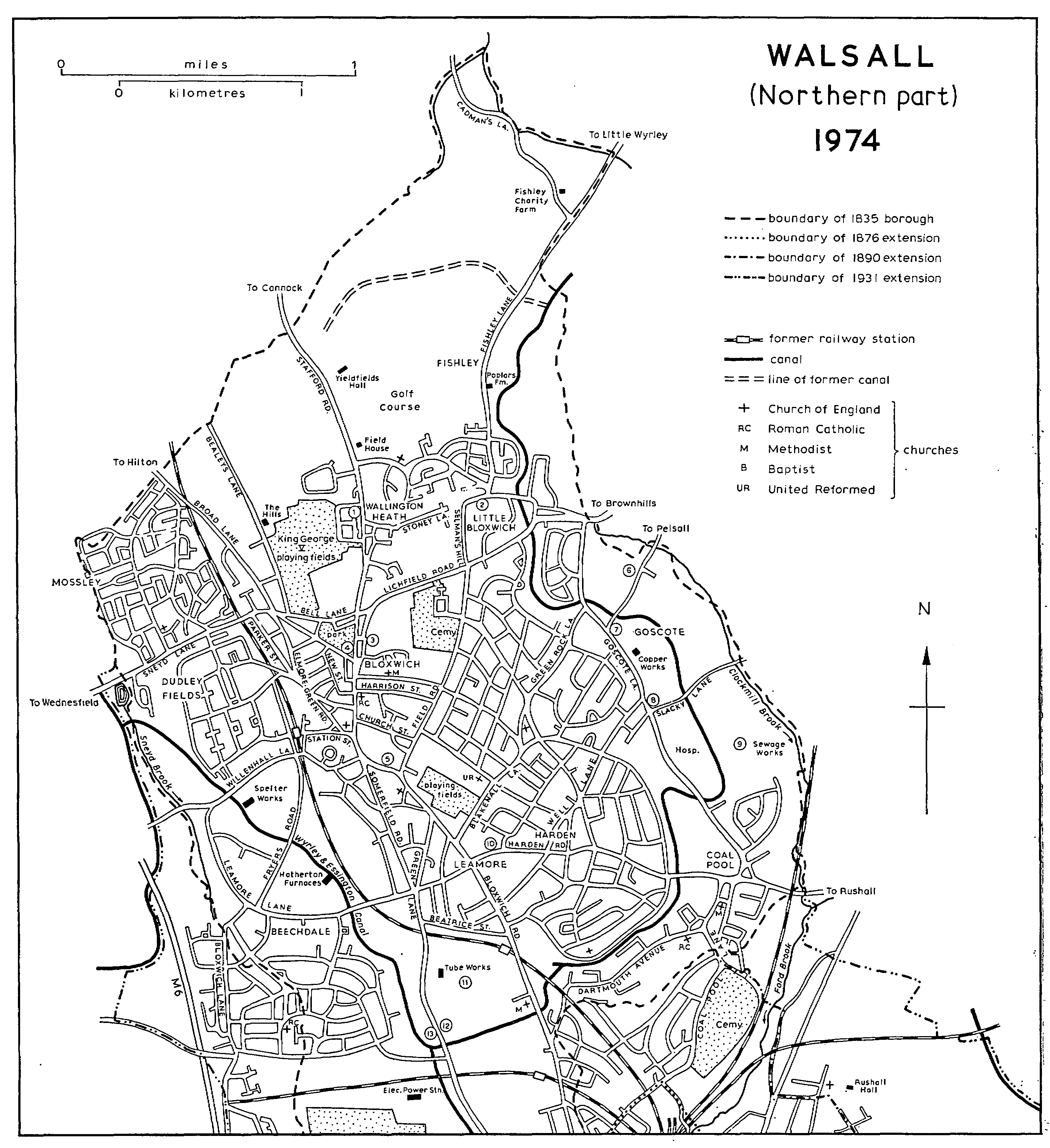
WALSALL (Northern part) 1974
KEY 1. Site of Wallington House 2. Site of Lower farm 3. Former Wesleyan chapel 4. Former Bloxwich Music Hall 5. Site of Primitive Methodist chapel 6. Site of Goscote foundry 7. Site of Goscote manor-house 8. Site of Goscote Hall 9. Site of Goscote Lodge 10. Former R.C. chapel 11. Site of Birchills Hall 12. Site of New Birchills furnaces 13. Site of Green Lanes Furnaces
To commemorate Queen Victoria's golden jubilee the council acquired 13 a. of the manorial waste in 1888 and laid out a 10-acre park on Bloxwich Green (the remains of Short Heath), opening it in 1890. (fn. 318) Houses were built on Lord Hatherton's land at the southern end of Field Road at the end of the century. (fn. 319) Some larger houses were built along the main road towards Wallington Heath about the same time. (fn. 320)
Between the World Wars council houses were built on the south side of Bloxwich and in Field Road and Broad Lane. The main areas of privately built houses were Victoria Street, Lichfield Road, Field Road, and Wallington Heath. The playingfields on the west side of Blakenall Lane originated as a war-memorial playing-field bought in 1925; it was laid out by the Miners' Welfare Committee in the early 1930s. The King George V Playingfields west of Wallington Heath date from the later 1930s. (fn. 321) Since the Second World War several more council estates have been built. They include one south of Lichfield Road and another at Dudley Fields south of Sneyd Lane, both dating from the later 1940s, and the Mossley estate north of Sneyd Lane dating from the later 1950s. (fn. 322) At Dudley Fields there is also an industrial estate of the later 1960s. (fn. 323) There are several estates of council flats. Those on cleared ground on either side of Alfred Street date from 1957 and the multi-storey blocks at the south end of High Street from the 1960s. (fn. 324) The Sandbank estate, consisting of three 12-storey blocks and one of 16 storeys, was begun in 1962 on a cleared site of 6 a. (fn. 325) Private building of houses has continued in the Wallington Heath area, including an estate laid out over the grounds of Wallington House after it had ceased to be a convent in the mid 1960s. (fn. 326) The area north of Wallington Heath to the boundary remains open country, occupied as farm-land (fn. 327) and by Bloxwich golf-course which dates from 1923 and has the 19th-century Field House as the clubhouse. (fn. 328)
By the later 18th century Little Bloxwich lay in the area formed by Little Bloxwich Lane (now Lichfield Road), Stoney Lane, and Selman's Hill. (fn. 329) It may originally have centred on the stretch of Stoney Lane between Fishley Lane and Selman's Hill where Little Bloxwich Green lay in the later 18th century. (fn. 330) Lower Farm, a late-medieval crucktrussed house, stood in that part of Stoney Lane until its demolition in 1963. (fn. 331) The site of Poplar Farm in Fishley Lane was formerly moated. (fn. 332) Little Bloxwich had its own common fields. (fn. 333) It also lay on the Walsall-Stafford road until 1766, when the route was diverted to run through Great Bloxwich, and it had a coaching-inn. (fn. 334) There were 182 recipients of Mollesley's Dole in 1619 and 259 in 1661. (fn. 335) The Wyrley and Essington Canal runs through the area, and by the 1880s there was a canal basin off Fishley Lane. In the later 19th and early 20th centuries there was coal-mining in the Fishley area to the north of Little Bloxwich, and there was a steam mill near the basin in the earlier 20th century. (fn. 336) Selman's Hill and Sanstone Road contain privately built houses of the period between the World Wars, and after the Second World War Little Bloxwich became an area of mixed council and private housing. The first council houses date from the late 1940s, and by the early 1960s there were 270 of them. (fn. 337) The Lower Farm estate centres on nine blocks of council flats completed in 1963, eight of three storeys and one of six; a block of shops and maisonettes was built at the same time. (fn. 338) Fishley is an area of farm-land.
Blakenall was mentioned c. 1300 when it was crossed by the road from Leamore to Goscote, the present Blakenall Lane and Green Rock Lane. (fn. 339) It was described as a heath in 1544. (fn. 340) By 1763 a settlement of cottages had grown up round the common on the triangle now formed by the streets called Blakenall Lane, Blakenall Heath, and Ingram Road, (fn. 341) and there were several metal-workers there by the early 19th century. (fn. 342) A school and mission centre was opened on the heath in 1843. (fn. 343) By 1843 houses had been built to the south-east of the heath along Harden Lane (now Walker Road) and Barracks Lane (so called by the 1880s). (fn. 344) By 1859 houses were being built to the south-west of the heath along Blakenall Lane; Foster Street existed then, and the district was described as 'thriving and rapidly improving'. (fn. 345) A Primitive Methodist chapel was built c. 1866 in Chapel Street. (fn. 346) The first part of Booth Street was built in 1871 on Lord Hatherton's land. (fn. 347) Between the two World Wars streets of council houses were built round the settlement and some privately built houses were also erected. (fn. 348) It was in Blakenall Lane in 1920 that the first council house in the borough was completed, (fn. 349) and by 1927 450 houses had been built on the Blakenall estate. (fn. 350) Houses, maisonettes, and multi-storey flats have been built since the Second World War, including an estate in Green Rock Lane dating from the later 1940s. (fn. 351)
The hamlet of Goscote, a name meaning a hut in the gorse, (fn. 352) existed by the end of the 13th century and apparently lay towards the north end of Goscote Lane. (fn. 353) There were 54 recipients of Mollesley's Dole in Goscote and Coal Pool in 1619 and 68 in Goscote alone in 1661. (fn. 354) Goscote Hall on the corner of Goscote and Slacky Lanes existed by the mid 18th century, and Goscote Lodge Farm between Slacky Lane and the present Hildicks Crescent by the early 19th century. (fn. 355) The Wyrley and Essington Canal was built through the area in the 1790s. (fn. 356) Mining of coal and ironstone started then, and there was a foundry by the early 1800s. (fn. 357) By 1834 there were four lock-makers. (fn. 358) There were two brickworks by 1858. (fn. 359) An isolation hospital was opened in Goscote Lane in 1930 and a sanatorium was added in 1933. (fn. 360) Council estates were built west of Goscote Lane and Livingstone Road in the later 1930s and after the Second World War; they included 50 houses on 6 a. previously occupied by pit mounds. (fn. 361) Also in Goscote Lane are an electro-plating works and a copper refinery dating from the later 1940s. (fn. 362)
Coal Pool, at the junction of Harden, Goscote, and Coal Pool Lanes, was an inhabited area by the 1540s when the Stone family held Coal Pool House. (fn. 363) There was a water-mill there by the late 17th century. (fn. 364) Land near the boundary called Far and Near Coal Pit Pieces in 1843 (fn. 365) suggests mining at some period. In the later 19th and earlier 20th centuries the main part of Coal Pool consisted of three rows of terraced houses east of Coal Pool Lane built evidently in the 1850s and occupied in 1861 mostly by coal-miners; they were demolished between the World Wars. A Wesleyan chapel was opened near by in 1852. (fn. 366) In the later 1930s a council estate was built at the south end of Goscote Lane, and a private estate had been built in Dartmouth Avenue by 1938. (fn. 367) The first council housing in Walsall after the Second World War was built at Coal Pool in the later 1940s, and more has been built there since. (fn. 368) In 1974 there was still some open ground along the canal north of Harden Road.
Harden, a hamlet lying around the junction of Harden Road, Broadstone Avenue, and Well Lane, existed by the late 13th century. (fn. 369) It had its own common fields. (fn. 370) There were 120 recipients of Mollesley's Dole in 1619 and 166 in 1652, figures which probably include Blakenall also; the combined recipients in Harden, Blakenall, and Coal Pool in 1661 numbered 171. (fn. 371) Coal was mined at Harden by the earlier 1850s, and mining continued in the vicinity until 1905. (fn. 372) The area now consists mainly of council estates, dating from the 1930s and the later 1940s; (fn. 373) there are also some privately built houses erected between the World Wars.
There was settlement in the Leamore area around Leamore Lane, Broadstone (now Bloxwich Road), and the northern end of Green Lane by 1775. (fn. 374) By the early 1840s there had been development on the south side of Leamore Lane, and Comwall Street, Portland (later Portsea) Street, and Providence Lane there were being built up by the 1880s. (fn. 375) Mining was in progress at Leamore in the 1850s and 1860s. (fn. 376) A Wesleyan chapel was opened in 1863, a board school in 1873, and an Anglican mission chapel in 1883. (fn. 377) The area was described by the vicar of Blakenall in the early 1880s as 'populous yet poor'. (fn. 378) By the beginning of the 20th century West Street on the north side of Leamore Lane had been laid out, and houses had been built along the east side of Bloxwich Road and on the south side of Hope Street. To the south of the railway two brickworks had been opened, and Carl Street, dating from 1895, had been built on the west side of Bloxwich Road. (fn. 379) May and Beatrice Streets, named after the daughters of the builder, John Wilkes, were laid out c. 1904. (fn. 380) A council estate, including flats, was built in the later 1920s; some of the houses were built on empty sites in existing streets, and the estate also included the new Somerfield Road, which runs from Green Lane directly to Bloxwich. (fn. 381) In 1959 the corporation began clearing 8½ a. south of Leamore Lane in order to replace 180 slum properties with a multi-storey estate of 280 dwellings. The work was completed in 1964. (fn. 382)
The area to the west and north-west (including part of Bentley transferred to Walsall in 1931) (fn. 383) consisted by the 1880s mainly of derelict ground covered with old mine shafts; the Hatherton Brickworks, the Hatherton Furnaces, and the Walsall Glue Works had been built along the Wyrley and Essington Canal. (fn. 384) That stretch of the canal remains industrialized, (fn. 385) and an industrial estate has been built in Leamore Lane since the Second World War. The large Beechdale (formerly Gipsy Lane) housing estate was built by the council in the early 1950s. (fn. 386)