A History of the County of York East Riding: Volume 6, the Borough and Liberties of Beverley. Originally published by Victoria County History, London, 1989.
This free content was digitised by double rekeying. All rights reserved.
A P Baggs, L M Brown, G C F Forster, I Hall, R E Horrox, G H R Kent, D Neave, 'Common Lands', in A History of the County of York East Riding: Volume 6, the Borough and Liberties of Beverley, ed. K J Allison (London, 1989), British History Online https://www.british-history.ac.uk/vch/yorks/east/vol6/pp211-218 [accessed 2 May 2025].
A P Baggs, L M Brown, G C F Forster, I Hall, R E Horrox, G H R Kent, D Neave, 'Common Lands', in A History of the County of York East Riding: Volume 6, the Borough and Liberties of Beverley. Edited by K J Allison (London, 1989), British History Online, accessed May 2, 2025, https://www.british-history.ac.uk/vch/yorks/east/vol6/pp211-218.
A P Baggs, L M Brown, G C F Forster, I Hall, R E Horrox, G H R Kent, D Neave. "Common Lands". A History of the County of York East Riding: Volume 6, the Borough and Liberties of Beverley. Ed. K J Allison (London, 1989), British History Online. Web. 2 May 2025. https://www.british-history.ac.uk/vch/yorks/east/vol6/pp211-218.
In this section
COMMON LANDS
The Agrarian Interests of the Town
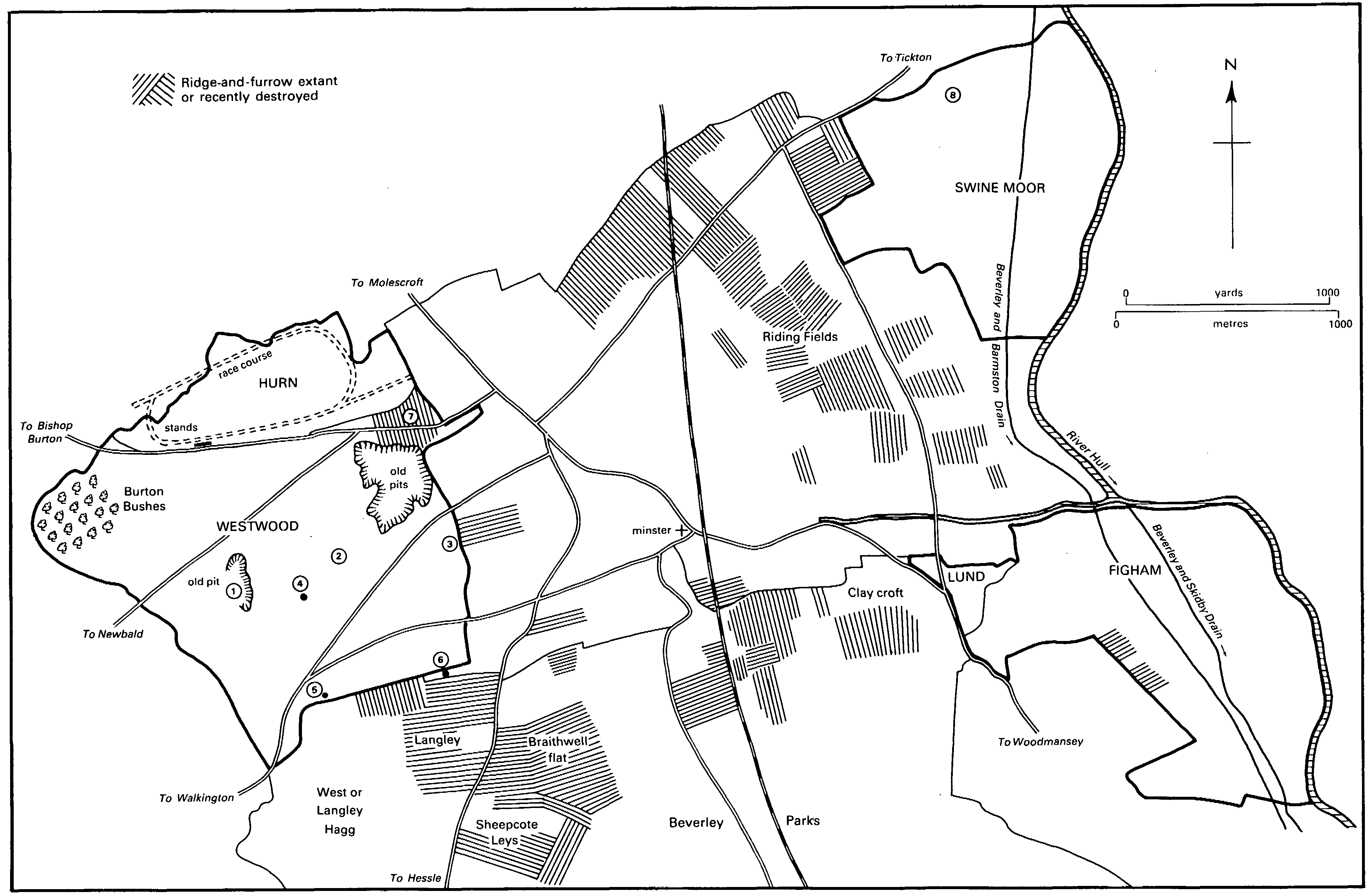
The common pastures of Figham, Swine Moor, and Westwood with Hurn, which still have a prominent place in the landscape around the town, (fn. 1) occupy a formerly wooded area on the wold slopes and low-lying grounds, at one time ill drained, beside the river Hull. By the later Middle Ages the ground between the builtup area and the common pastures was occupied by many crofts and closes, which were especially extensive on the east side of the town and which belonged to numerous individuals and institutions. It was presumably there that much of the land for seven ploughteams recorded in 1086 (fn. 2) lay and it is tempting to suppose that the arable land was in the earlier Middle Ages managed as open or common fields. There are no definite references to open fields at Beverley. The word 'selion', usually meaning a strip of open-field land, was, however, later used to describe ground in the closes. By the early 15th century, for example, there were selions, then used as meadow, at Grovehill, and others in 'the field of Ridding'. (fn. 3) Ridding, meaning cleared or assarted land, lay between the town and Swine Moor, and the name Riding fields survived into the 20th century. (fn. 4) Parcels within meadow closes such as Keldgate leys were also occasionally described as selions. (fn. 5) Other names suggestive of open-field land were given to grounds adjoining the archbishop's deer park, south of the town. Thus two culture, one called Langley, were recorded c. 1280, (fn. 6) and a cultura called Clay field and a close known as Braithwell 'flat' were mentioned in 1309. (fn. 7) The only other indication of former open-field land is the ridge-and-furrow which survives in various places around the town, including Riding fields and the grounds beside the park, and which was until recent years much more extensive. (fn. 8)
Although it did not explicitly refer to the open fields, an agreement made by the townspeople and Sewall de Bovill, archbishop 1255-8, (fn. 9) suggests that the fields may have been involved in the conflict over pasturage and other rights which had existed between people and archbishop earlier in the century. (fn. 10) The archbishop conceded that a boundary should be made between Westwood and the arable land so that no more of the pasture was converted to tillage. That arable land may have lain between Westwood and the archbishop's park or between Westwood and the town ditch, places where ridge-and-furrow still exists. He also granted the townsmen meadow and arable land called 'Utengs' or Out ings, lying between New dike and Figham. Out ings, the precise location of which is not known, may later have been incorporated in Figham. Part of Figham adjoining Woodmansey was evidently at some time in cultivation for it still contains ridge-and-furrow. The archbishop also gave the townsmen free pannage in the woods of Hagg and Westwood. (fn. 11) In return they gave up their claim to common of pasture in the park and in Stone carr, in Weel. After renewed dispute the agreement was confirmed by Archbishop Wickwane in 1282. (fn. 12) Any open-field land that may have existed south of the town, adjoining the park, had evidently been inclosed by the 14th century, (fn. 13) and the open fields elsewhere around the town were presumably also inclosed by then.
Beverley: Common Lands, 1988
1. Site of limekiln 2. Site of Low Mill 3. Site of Butt close and mill 4. Remains of High Mill 5. Remains of Union Mill (golf club house) 6. Remains of mill 7. Low Green 8. Site of spa
If open fields there were, their inclosure and the consequent loss to the townsmen of common rights in fallow and harvest fields may explain the rights of average which the burgesses collectively later enjoyed in many of the closes and crofts: those rights may have been given in compensation. Average was usually enjoyed from 29 September to 2 February, (fn. 14) and it was stinted; (fn. 15) sheep were excluded and average was mostly used for horses. (fn. 16) The first known reference to average was in 1407, when a survey was made after some landowners had deprived the burgesses of it; 13 crofts were listed, together with a few lanes and roads, and in one of those crofts average had been withheld for as long as five years. (fn. 17) In 1429 disfranchisement was threatened for those who withheld the average of their crofts, and two men were temporarily disfranchised in 1440; (fn. 18) others were occasionally punished for the same offence. (fn. 19) An order to let the average for three years, denying it to the commoners, was made in 1434 but rescinded the next year. (fn. 20) The leasing of the average of two crofts in 1441 (fn. 21) was, however, followed by other leases in the 16th and early 17th century, (fn. 22) and the whole of the town's average was occasionally let to butchers or others for their sheep. (fn. 23) In 1567-8 a claim by the townsmen to enjoy average after harvest in the open fields of Molescroft was upheld, (fn. 24) a privilege not recorded again. It was apparently in 1599 that the townsmen first laid claim to average in Langley and Langley Hagg, adjoining the former archbishop's park, and they were successful after several years of dispute with lessees of Sir Michael Warton. (fn. 25) There were at least 36 closes, including Keldgate leys, in the average in 1573 and at least 74, including 26 in Langley, in 1606-7. (fn. 26)
The town's financial straits led to a decision in 1627 to survey the average and offer it for sale to the owners of the closes, and over £220 was raised in 1628-30. (fn. 27) Those who did not wish to buy were offered leases in 1631 for a high fine and nominal annual rent, and both the sale and letting of average continued until 1684: the sale of average in Keldgate leys that year (fn. 28) probably saw an end to that source of the borough's income.
The Common Pastures
The origins of the townsmen's rights in the common pastures are unknown. (fn. 29) In 1201, after the archbishop had dispossessed the townsmen of their pasturage and other rights, the king gave them full seisin 'according to their charters'. (fn. 30) The charters of c. 1122 and later, however, made only a vague reference to pasturage by the grant of 'free ingress and egress in the town and without the town and in the plain and wood and marsh in ways and in paths and other conveniences except in meadows and cornfields'. (fn. 31) Figham and Westwood have not been found mentioned by name until the agreement with Archbishop de Bovill c. 1255. (fn. 32) Figham evidently already belonged to the town. The archbishop retained the ownership of Westwood but granted the townsmen free pannage and gave up his own agistment there. Ownership of Westwood was eventually granted to the town by the archbishop for £5 a year in 1379-80. (fn. 33) Swine Moor was mentioned from 1277, when it was called the pasture of Peter of Chester, provost of Beverley. (fn. 34) It had apparently passed to the town by 1344. (fn. 35) In 1399 rights there were enjoyed by the inhabitants of Stork and Sandholme, (fn. 36) and presumably also by the townsmen. Several small pieces of waste ground were also sometimes described as common pastures. (fn. 37)
No changes in the boundaries of Swine Moor have been recorded. Figham may have been enlarged by the incorporation of Out ings after c. 1255 (fn. 38) and of the Tong after 1501. It has been suggested that the Tong, which lay on the south side of Beverley beck near its junction with the river, was a common pasture, (fn. 39) but it was in fact a close of which the herbage was let by the town in the Middle Ages. It was lost to the town by exchange in 1501 (fn. 40) but it was evidently regained and by the 18th century was part of Figham. (fn. 41) For long periods Figham included ground called Lund, which also belonged to the town. Lund, or Little Lund, was used as common pasture at least from 1416-17, (fn. 42) but in 1609 it was decided that it should no longer be laid open to Figham but kept several for the town's purposes, (fn. 43) and later it was often let. (fn. 44) In 1764, however, Lund was ordered to be joined to Figham once more and, although execution of the order was delayed by flooding, (fn. 45) it has since remained so. In the late 19th and the 20th century parts of Figham near the beck were taken for a rifle range, used from 1872 to 1894, (fn. 46) and for the depositing of sludge from the sewerage works, and they were still fenced off from the pasture in 1988; other ground was sold in 1979 as the site for a pumping station. (fn. 47) Several changes have been made to the boundaries of Westwood. Inclosures known as the North and South parrocks were mentioned in the 16th century (fn. 48) and the northernmost part of Westwood was known as Hurn at least from 1547. (fn. 49) A close called Horse or Low Green, beside the York road next to the town, was added to Westwood in 1656, when the corporation acquired it from Michael Warton. (fn. 50) Butt close, on the eastern edge of Westwood, may have been taken out of the pasture by the town. It was mentioned from 1580. (fn. 51) In 1861 a crowd of burgesses, asserting that the close should be theirs, destroyed the hedge around it and the mill house within, but the corporation maintained its right to the close and soon afterwards let it to a new tenant. In 1863, however, the tenant sublet it to the pasture masters (fn. 52) and it has since remained open to Westwood. (fn. 53) Small additions to Hurn were made to improve the racecourse there. (fn. 54)
When the acreage of the pastures was reliably set down in 1836 Figham comprised 297 a., Hurn 110 a., Swine Moor 263 a., and Westwood 504 a., and the pasture masters leased from the corporation Figham banks and Swine Moor banks, each containing 14 a., and the 15-a. Lund. (fn. 55) Those were still regarded as the approximate acreages in 1977, when the pastures were registered as common land; Lund and Butt close were excluded from registration. (fn. 56)
Use of the common pastures was not entirely restricted to the townsmen of Beverley. Thus rights in Swine Moor were enjoyed by the inhabitants of Stork and Sandholme from the late 14th century, and they still had 40 gates there in the early 19th century. (fn. 57) Four gates there belonged in the early 19th century to the corporation, which had obtained them in 1787 from the Keld family. (fn. 58) Sixteen others belonged to the Brighams. They had been sold in 1713 by Edward Thompson to Sir Charles Hotham, Bt., in 1766 by Hotham's grandson Sir Charles Hotham, Bt., to John Johnston, in 1773 to Sir James Pennyman, Bt., in 1781 to William Bethell, in 1799 to William H. Pennyman, and in 1805 to William Brigham. (fn. 59) Rights in Figham were withdrawn by Archbishop de Bovill from the inhabitants of Woodmansey as part of the agreement made c. 1255. (fn. 60) In Westwood the archbishop's grant of the pasture to the townsmen in 1379-80 reserved to him and his tenants at Bishop Burton the right to feed their pigs there. (fn. 61) The townsmen later found that right irksome. They disapproved of free-roaming pigs, and in 1572 Bishop Burton men were ordered to ring their animals. (fn. 62) The townsmen impounded a Bishop Burton man's sheep discovered in the pasture in 1663. (fn. 63) It was ordered at York assizes in 1685 that swine should be ringed, but Beverley had to remind Bishop Burton of that order in 1693 (fn. 64) and another suit between them was in progress in 1717. (fn. 65) In 1836 it was said that the common of pasture for pigs belonging to Bishop Burton in that part of Westwood called Burton Hill had not been exercised for many years, and it was then extinguished upon payment of compensation to the parish officers. (fn. 66) The right belonging to Bishop Burton may explain why trees, which were cleared from the rest of Westwood, were left on the high ground at Burton Bushes. (fn. 67) Killingwoldgraves hospital, in Bishop Burton, also had a right to use Westwood, perhaps dating from 1399 when the hospital sought licence from the town to keep a bull, 12 sheep, and 20 pigs there. (fn. 68) After the suppression of the hospital, Crown grants of its property in the late 16th century included pasture for 2 bulls and 6 cows in Westwood. (fn. 69) The corporation disputed the right in 1588, alleging that the hospital's licence had been given annually and was not permanent, (fn. 70) and again in 1657. (fn. 71) In the early 19th century 4 cows from Killingwoldgraves farm were still depastured there, (fn. 72) and the corporation had 4 other gates which it had obtained from the Kelds in 1787. (fn. 73)
Management until 1836
In the earlier 15th century two of the town keepers were designated each year to supervise each of the pastures, which also had their own shepherds. Later in the century a salaried supervisor was appointed for each pasture. (fn. 74) In the following century unpaid masters were chosen from among the governors. Thus in 1558 Figham, Swine Moor, and Westwood each had two masters, together with a cowherd, (fn. 75) while in 1577 Westwood was managed by two surveyors and two masters and Figham and Swine Moor together by a similar quartet of officers. (fn. 76) By the 1640s four pasture masters each were chosen for the three pastures, those of Westwood occasionally being called woodmasters. (fn. 77) In 1660 it was the custom for each group to consist of two governors and two burgesses (fn. 78) and by the early 19th century of two aldermen and two capital burgesses. (fn. 79) The Westwood officers also looked after Hurn. The pasture masters were responsible for such matters as driving the pastures, enforcing stints, collecting 'head money', and supervising the upkeep of ditches and fences and the improvement of the pasturage. (fn. 80)
Each pasture may originally have been intended for one kind of animal, as is suggested by the names Swine Moor and Figham, from 'Fegang' or 'cattle track', (fn. 81) and by the suitability of the oak woodland of Westwood for pigs. Any such rigid specialization was later discarded. (fn. 82) Payments made for burgesses' animals suggest that 'head money' was collected from Figham and Swine Moor by the 14th century and from Westwood by the mid 16th century. (fn. 83) To preserve the pasturage animals were excluded for a period each year: in the 16th and 17th centuries the pastures were usually 'laid' on 2 February or 25 March and 'broken' or opened up on 3 May. (fn. 84) By the 16th century the pastures were stinted, and those guilty of surcharging were frequently fined. (fn. 85) The privilege of stocking the pastures was enjoyed mainly by resident burgesses, although in the 16th century and later a few officers and town clergymen were allowed honorary horse gates. (fn. 86) Burgesses were not permitted to put in other men's animals, and from the late 16th to the early 19th century the corporation tried to stop the fraudulent use of the pastures by non-resident burgesses. (fn. 87) The total number of animals kept in the pastures is known only for Hurn and Westwood from 1744 to 1761 and from 1798 to 1831, for Figham from 1762 to 1792, and for Swine Moor from 1787 to 1836. There were usually 150-200 horses a year in Hurn; the cows in Westwood usually numbered 200-300 a year c. 1750, 300-400 in 1798-1811, often 400-450 in 1812-30, and over 500 in 1831; and there were another 50 horses and 20 cows after the two pastures were put together each August. In Figham there were 100-200 horses and at first fewer than 100 cows, but from 1780 often 100-150. In Swine Moor there were usually 200-300 animals, sometimes more, especially after 1820; when details were given horses usually outnumbered cows. (fn. 88)
The improvement of the pastures was pursued energetically in the 18th and early 19th century, when the corporation frequently provided money for it. On Hurn and Westwood the work involved stubbing up old tree roots, clearing bushes, levelling mounds, spreading soil, mowing thistles and 'yellow weed', and sowing grass seed. In 1814 a man was paid for cleansing the walks in Burton Bushes, presumably for the use of strollers from the town. (fn. 89) Water was available on Westwood at several springs and wells. The pit in which Cobbler well lay in the 19th century was presumably the shoemakers' pit mentioned in 1577. (fn. 90) The reliability of the wells is suggested by the granting of permission in 1568-9 to the inhabitants of Walkington to water their cattle once a day on Westwood 'until God sends them water'. (fn. 91) In 1784 a new watering pond was made on Westwood by John Gardener, (fn. 92) perhaps a relative of Robert Gardener of Kilham, who was said to have perfected a method of making dew ponds c. 1775. (fn. 93) Other new ponds were made in the 19th century and a reservoir was constructed at one of them in 1859; (fn. 94) only one pond remained on Hurn and Westwood in 1987. Cottages were provided for the cowherds at the main entrances to the pastures: those for Figham and Swine Moor were built in 1824 and 1869 respectively, and that for Westwood was rebuilt in 1856. (fn. 95)
On Figham and Swine Moor drainage was a serious problem. Both pastures suffered from flooding (fn. 96) and much attention was given to the maintenance of river banks and sluices. (fn. 97) Because of the difficulty of discharging water directly into the river, the archbishop agreed in 1536 that water from Figham might be taken southwards through Thearne. (fn. 98) An attempt was made by the corporation to render the Figham sluice more effective by building an 'engine', apparently a steam pump, in 1749 but it broke down in 1767. (fn. 99) Under an Act of 1785 Figham was placed within the jurisdiction of the new Beverley and Skidby Drainage Board; by the award made in 1788 the whole of Figham and Lund, together with 13 a. of adjoining closes, was rated to the drainage. (fn. 100) Swine Moor was dealt with by the Beverley and Barmston Drainage Board, formed under an Act of 1798; (fn. 101) the new main drain was dug across Swine Moor in 1802, and by the award made in 1811 most of the pasture and well over 100 a. of closes in Beverley were rated to the drainage. (fn. 102) The Beverley and Barmston drain also crosses Figham but has no part in its drainage.
Management since 1836
The corporation's ownership of the common pastures and its powers to regulate them were thrown into doubt by the Municipal Corporations Act of 1835. Early in 1836 the freemen therefore placed a Bill in parliament to vest the pastures in a body of pasture masters. The corporation objected to the terms of the Bill, in particular the vesting of the ownership of the soil in the freemen, and heated public debate took place before the Act was passed later in the year. (fn. 103) The Beverley Pastures Act (fn. 104) provided for the keeping of a list of resident pasture freemen who should annually elect 12 pasture masters and 2 auditors: that was first done in October 1836. Resident widows were to keep their husbands' rights, and the pasture freemen were to be allowed to sell their gates if they did not wish to use them. The pasture masters were empowered to collect 'head money' from the freemen for their animals, make regulations for the pastures, maintain fences, roads, and the like, impound and sell cattle pastured illegally, and buy gates from owners to extinguish them. It was expressly stated, however, that the Act was not to affect anyone's claim to the ownership of the soil, and it was not to debar the public from using the pastures for exercise, amusement, and recreation.
Disputes soon arose after 1836 between the town council and the pasture masters over the latter's right to enjoy any assets other than pasturage, i.e. trees, windmills, chalk, and the racecourse grandstand. (fn. 105) In 1839, however, the council resolved that the pasture masters should be entitled to those assets provided that they consulted with persons appointed by the council before felling trees so that some should be left for ornament. That surrender was evidently objectionable to some councillors and many ratepayers. (fn. 106) Continuing dissatisfaction with the existing arrangements came to a head in 1898 with a long debate in the town council; a resolution that the management of the pastures should be vested in the council was, however, lost. (fn. 107) Soon afterwards the Beverley Pasture Freemen's Association was formed to protect the interests of the freemen, though it was evidently short lived. (fn. 108) Management was not thereafter in question, and it was not until 1968, when registration of the pastures as common land was sought, that it became necessary to settle the question of the ownership of the soil. A public inquiry was held in 1977 to consider the rival claims of the pasture masters and Beverley Borough council, the district council which had succeeded the town council at local government reorganization in 1974. In 1978 the Chief Commons Commissioner found in favour of the council; the working of the 1836 Act was not to be affected by his decision. (fn. 109)
After 1836 many freemen and widows benefited by receiving a payment from the pasture masters out of the annual income of the pastures, rather than by putting in their own stock. In 1842-3, for example, 202 people put 407 animals in Figham, 124 put 397 in Swine Moor, and 295 put 759 in Westwood and Hurn, a total of 621 stockers and 1,563 animals; at the same time there were 483 non-stockers. (fn. 110) During the later 19th century there were often 500-600 nonstockers, and in 1896-7 only 143 people used their gates. (fn. 111) In the early 20th century well over 1,000 animals were pastured each year but there were often c. 400 non-stockers applying for payment. (fn. 112) By 1922 the pasture masters were concerned about their reduced income because of the ever-decreasing number of freemen in the borough and the consequent reduction in stocking. At a special meeting of all pasture freemen it was therefore decided to allow unwanted gates to be let, at £3 each, to nonfreemen. (fn. 113) In 1928, a good year, 743 gates were taken by freemen and 131 by non-freemen, but in 1929 numbers were down to 563 and 113. In 1930 they stood at 514½ and 169½ respectively but in 1932 at only 417½ and 65. The number of non-stockers was still 350-400 each year. (fn. 114) During the Second World War parts of Figham, Hurn, and Westwood were put under the plough. (fn. 115)
Few of the so-called privilege gates belonging to others than freemen were bought and extinguished by the pasture masters as authorized by the 1836 Act. The 16 gates belonging to William Brigham were sold by his grandson Henry Brigham in two lots in 1875. Eight went to James Dawson (d. 1899) and later belonged to his trustees. (fn. 116) The others went to Thomas Stephenson (fn. 117) and in 1920 were sold in two lots: four of them were extinguished by the pasture masters in 1947 (fn. 118) but the other four still existed as late as 1965. (fn. 119)
By 1968 the total number of gates in the pastures was limited by the pasture masters to 540. About 350 freemen and widows were entitled to gates, each of which comprised 1 horse or 1 beast or 4 hogs or 2 sheep. In addition the corporation and the owners of Killingwoldgraves farm each still enjoyed 4 gates on Westwood and Hurn, and the corporation had 4 and the Dawson trustees 8 on Swine Moor. (fn. 120) The 40 gates on Swine Moor belonging to Storkhill and Sandholme passed to the owner of Storkhill farm and were also still enjoyed in 1985. Only four freemen then used their gates and most of the animals on the pastures belonged to 47 local farmers who rented gates. (fn. 121) The drainage of Figham and Swine Moor was taken over from the Beverley and Barmston Drainage Board in 1941 by the River Hull Catchment Board and from the Beverley and Skidby Drainage Board at its abolition in 1956 by the Hull and East Yorkshire River Board; (fn. 122) responsibility later passed to the Yorkshire Water Authority. Parts of both pastures, but more especially of Figham, were still wetland in 1988. The construction of larger banks to prevent flooding from the river Hull began in 1986.
Other Uses of the Pastures
Apart from their primary value the common pastures have provided a variety of other assets for the corporation and the townspeople. Trees and other vegetation have been cut, and chalk and clay dug and burnt. Windmills were built on Westwood, a well on Swine Moor was converted to a spa, (fn. 123) and Westwood and Hurn have been the scene of horse racing and other sports, besides military gatherings and manoeuvres over a long period. (fn. 124)
Westwood and Hurn seem to have been originally largely wooded. They presumably comprised the pasturable woodland measuring 3 by 1½ leagues that was recorded in 1086, (fn. 125) and 'the wood called Westwood' was often referred to later. (fn. 126) Most of the trees were oaks but there were also many ashes and willows. (fn. 127) The underwood was regularly cut for 'kids' or faggots, (fn. 128) and bracken was gathered by the burgesses. (fn. 129) On Figham and Swine Moor willow loppings contributed to the income from faggots, and 'basses' or rushes were also cut. (fn. 130) The woodland also provided cover for game-birds and several 'cockshoots' on Westwood were let by the town. (fn. 131) Fishing and fowling on Figham and Swine Moor were enjoyed by the burgesses or were let. (fn. 132)
In the Middle Ages trees from Westwood were used to repair town property, some were sold, and others were felled and stolen by townspeople. Large-scale felling apparently began in the 16th century as a financial expedient. Some trees were no doubt taken at random, but use may also have been made of the local practice of dividing woodland into 'haggs' or 'springs' which were cut and protected in turn. (fn. 133) A new hagg on Westwood was mentioned from 1573 (fn. 134) and a hagg in Hurn in 1595, (fn. 135) and another in Hurn was ordered to be made in 1604. (fn. 136) The first large sale of timber recorded was of more than 300 trees in 1562-3 and others included 818 trees and stumps in 1584-5 and 1,174 in 1585-6. (fn. 137) It was decided in 1594, when money was urgently needed, to sell the trees in Westwood from Farley Green to the cockpit and from South parrock into Newbald dale, and in 1595 to cut all the wood in Hurn except 1,000 oak and ash 'standers', 300 more to be left only if the mayor and governors would pay for them. (fn. 138) Sales continued in the early 17th century. (fn. 139) In 1638 all the trees in Westwood were said to be decayed and were being stolen and their sale was therefore ordered, and in 1649-50 nearly 150 trees were taken from Hurn. (fn. 140) Another 454 trees from Hurn were sold in the 1690s. (fn. 141) Finally, in 1765, all the oaks in Westwood and Hurn that were not 'improvable' were sold. (fn. 142) By then little was left but the trees in Burton Bushes, a piece of woodland at the farthest edge of Westwood which may have been preserved to provide food for the pigs from Bishop Burton. (fn. 143) Some new trees were planted from the 1750s, (fn. 144) but an order made in 1792 that plantations should be made was revoked the next year so that the burgesses should not be deprived of herbage. (fn. 145) In 1896-7, as the result of gifts and subscriptions, several long avenues of trees were planted along the roads crossing Westwood. (fn. 146)
A limekiln was reserved to the archbishop when he granted Westwood to the town in 137980. (fn. 147) A chalk quarry there with one or two limekilns was let by the town at least from the late 14th century (fn. 148) until the early 19th. (fn. 149) The remaining kiln was last used in 1813 and demolished in 1818. (fn. 150) It presumably stood in a chalk pit near the Newbald road, not far from the borough boundary. (fn. 151) There were other chalk pits near the York road, close to the town. Sand, gravel, and stones were also dug on Westwood, (fn. 152) and clay there was occasionally used for brickmaking as when Sir Charles Hotham, Bt., had leave to do so in 1716. (fn. 153) In the 17th century potters dug clay on Swine Moor, (fn. 154) there was a brickyard there, (fn. 155) and a man was allowed in 1667 to take sods from there to make a bowling green. (fn. 156)
The rising ground of Westwood was a convenient site for windmills. A corporation mill mentioned in 1577-8 and later was presumably a windmill, (fn. 157) and a windmill was certainly built on Westwood a few years before 1625, when it was alleged to be prejudicial to the water mills in Beverley and Beverley Parks. (fn. 158) The corporation certainly had a windmill on Westwood from 1646-7, (fn. 159) later known as First, Low, or Hither Mill. It was blown down shortly before 1715 and may have stayed down until it was rebuilt in 1742. (fn. 160) In 1773 a new lessee undertook to rebuild it in brick and that had been done by 1775. (fn. 161) The mill, which stood in the middle of Westwood, was ruinous in 1856 and the machinery and remains of the building were sold the same year. (fn. 162) A second windmill, variously known as High, Far, Black, or Baitson's Mill, was later built by the corporation a short distance from Low Mill. As 'new mill' it was mentioned from 1654-5. (fn. 163) A new lessee in 1802 undertook to rebuild the mill and had done so by 1803. (fn. 164) The sails were blown down in 1868 and the mill was dismantled, but the tower was repaired (fn. 165) and remained in 1988. In 1761 the corporation let part of Butt close, on the eastern edge of Westwood, with licence for the lessee to build a windmill. (fn. 166) Butt close or Fishwick's Mill was a post mill; (fn. 167) it was demolished in 1861. (fn. 168) Another mill was built in a close adjoining the southern boundary of Westwood in 1802. (fn. 169) It was worked until the 1890s (fn. 170) and the lower part of the tower still stood in 1988. The Union Mill Society was formed in 1799 (fn. 171) to run a co-operative mill, and in 1800 built the Anti-mill as it was sometimes called near the south-western corner of Westwood. (fn. 172) The society still existed in 1864 (fn. 173) but the mill was later worked privately, probably until the 1890s. (fn. 174) The lower part of the tower survived, as part of the golf course club house, in 1988.
A golf course was laid out on Westwood after the Beverley and East Riding Golf Club was formed in 1889. A pavilion was erected near Black Mill in 1891 (fn. 175) and moved in 1906 to the Anti-mill, with which it formed a new club house. (fn. 176) The racecourse is discussed elsewhere. (fn. 177)