Survey of London: Volumes 29 and 30, St James Westminster, Part 1. Originally published by London County Council, London, 1960.
This free content was digitised by double rekeying. All rights reserved.
'St. James's Square: General', in Survey of London: Volumes 29 and 30, St James Westminster, Part 1, ed. F H W Sheppard (London, 1960), British History Online https://www.british-history.ac.uk/survey-london/vols29-30/pt1/pp56-76 [accessed 30 April 2025].
'St. James's Square: General', in Survey of London: Volumes 29 and 30, St James Westminster, Part 1. Edited by F H W Sheppard (London, 1960), British History Online, accessed April 30, 2025, https://www.british-history.ac.uk/survey-london/vols29-30/pt1/pp56-76.
"St. James's Square: General". Survey of London: Volumes 29 and 30, St James Westminster, Part 1. Ed. F H W Sheppard (London, 1960), British History Online. Web. 30 April 2025. https://www.british-history.ac.uk/survey-london/vols29-30/pt1/pp56-76.
In this section
CHAPTER IV
St. James's Square
The grant by Charles II of the freehold of the site of St. James's Square and other adjacent property to trustees for the Earl of St. Albans was made on 1 April 1665. The square itself took shape in the 1670's. But the building activities of St. Albans and his plans for the freehold area dated from the lengthening, in September 1662, of his leasehold interest in Pall Mall (St. James's) Field until 1720. This had been accompanied by a licence to his trustees, Harvey and Coell, to 'frame erect alter take downe new build and sett up' as many houses as they thought fit, 'according to such designes and plotts as . . . his . . . majestie his heires or Successors under his or their Privy Signett Privy scale or greate Scale and his or their Surveyor Generall' should approve. (fn. 44) (fn. 1)
On the strength of this lease St. Albans began to develop the field, and there are a number of references to his activities in the following year. Sir Balthazar Gerbier's Counsel and Advise to all Builders of 1663 contains among its numerous dedications one to St. Albans and mentions the burning of lime by 'your Lordships Builders in St. James-fields'. In May the French traveller Monconys described Pall Mall as situated 'au côté d'une grandissime place qui peut être quatre fois la place Royale et deux fois Belle-Cour; elle appartient au Milord St. Alban, qui y va faire faire des bâtiments qui la détruiront'. (fn. 45) In the following month a Bill was introduced into the House of Commons renewing the attempt to prevent by legislation the further growth of London. The Bill seems not to have progressed beyond the committee stage. (fn. 46) It provoked, however, the printing of an unsigned petition stating 'the Case of the Builders in and near St. James's Fields'. (fn. 47) They pointed to the profit which the Crown would derive from the development when the leasehold interests of the builders expired. But the petitioners' chief argument was that 'his Majesty intending those Places near unto his Majestie's Pallaces of White-Hall and St. James's should be Built for the conveniency of the Nobility and Gentry who were to attend upon his Majestie's Person, and in Parliament; and for the better Ornament of the Place, Directed by his Officers, not only the said Buildings, but the form and Manner also'. They claimed explicitly that they had had 'his Majestie's Officers for the Plotters, Designers and Contrivers of the said Buildings'. (fn. 47) The Crown's control of building-design required in the lease of 1662 may therefore have been in some degree a reality.
Hostility to the development was felt by the City of London, probably from fear of competition for water supply: but the royal support for St. Albans's project discouraged opposition. In September Pepys wrote: 'my Lord Mayor told me . . . that this City is as well watered as any city in the world, and that the bringing the water to the City hath cost it first and last above £300,000; but by the new building and the building of St. James's by my Lord St. Albans, which is now about (and which the City stomach I perceive highly, but dare not oppose it), were it now to be done, it would not be done for a million of money.' (fn. 48)
The royal interest had been cited by St. Albans himself when in August 1663 he had petitioned for a grant of the freehold of the intended site of the square. This rehearsed that 'ye beauty of this great Towne and ye convenience of your Court are defective in point of houses fitt for ye dwellings of Noble men and other Persons of quality, and that your Majesty hath thought fitt for some Remedy hereof to appoint yt ye Place in St. James Field should be built in great and good houses'. At that time the intention was that the square should consist of houses of the greatest size. It had evidently been found that it would not be possible to dispose of sites for such large mansions under sub-leases and that they would only be taken if the occupier could enjoy the freehold. St. Albans therefore represented that 'unlesse your Majestie be pleased to grant ye inheritance of ye Ground whereon some 13 or 14 houses yt will compose ye said Place are to stand, it will be very hard to attaine ye end proposed for yt men will not build Pallaces upon any terme but yt of Inheritance'. (fn. 49) St. Albans thus early declared his intention to sell outright and not merely lease his property surrounding the square. (fn. 2)
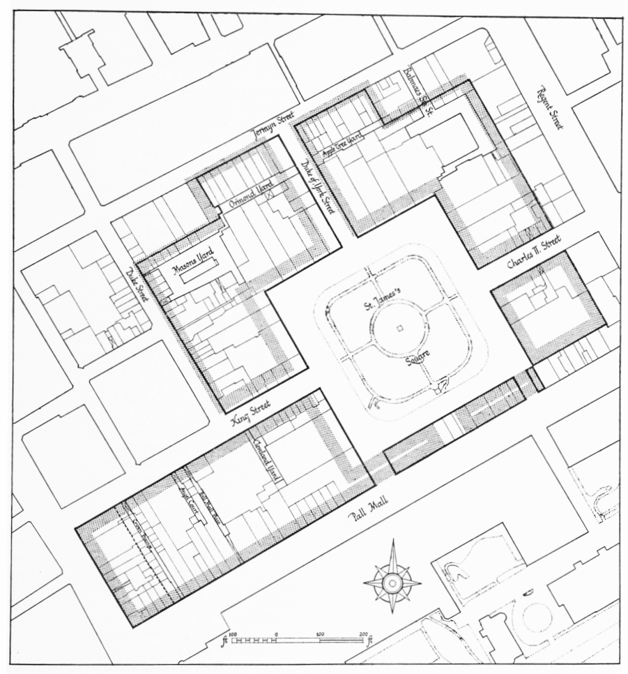
Earl of St. Albans's freehold, layout plan. Based on the Ordnance Survey and plans in the Public Record Office
The bold line indicates the boundary of the freehold as built. The stippled portion indicates the layout originally intended in 1665. The broken line west of Crown Passage probably indicates the eastern limit of the Physic Garden (see page 25, n.)
Some building went on throughout 1664 and was commented on by Sorbière. Like Monconys he remarked on the size of the project compared with Belle Cour at Lyons, perhaps because both thought the square was to occupy all the area then unbuilt. (fn. 50) In August of the same year John Evelyn complimented St. Albans, together with Lords Clarendon and Southampton, on his part in the erection of 'large and magnificent Structures'. These, under royal encouragement, were introducing a 'renascence' of architecture. (fn. 51)
The grant of the freehold was not made immediately, perhaps partly because, as St. Albans complained in an urgent letter of December 1663, his petition was mislaid by the Secretary of State, Sir Henry Bennet, later Lord Arlington, during a trip to Bath. (fn. 52) It was in fact a year or so after St. Albans's petition that a warrant was made out for the grant, on 23 September 1664. In January and February 1664/5 the preparation of the grant proceeded through its appointed stages, (fn. 53) but there appears to have been a final slight delay, and on 25 March Arlington, who a few months later was to be the first purchaser of a site in the square, was obliged to direct the Lord Chancellor to put the great seal 'without any more delay to My Lord of St. Albans grant . . . and this though your Lordship should not have My Lord Treasurers recommendation'. (fn. 54) The Lord Treasurer was the Earl of Southampton: it is not known whether solicitude for the success of his own estate then being developed in Bloomsbury was responsible for any deliberate obstruction of St. Albans's project on his part.
On 1 April 1665 the grant of the freehold site was made by letters patent to Baptist May, Privy Purse and 'court pimp', and Abraham Cowley, the poet and St. Albans's protégé, in trust for St. Albans. (fn. 55) A ground-rent of £80 per annum was reserved. The control of building-design imposed in 1662 was reaffirmed. The area granted was described in eleven plots. A plan accompanying the patent, which survived in 1740 and was then copied, (fn. 56) shows that the intended layout differed somewhat from that actually built (fig. 3). This difference will be discussed below, but an added complexity resulted from a blunder in drafting the patent.
When the first warrant for the grant had been made out in September 1664 the description of the area to be conveyed was substantially as in the final patent. But the warrant included in addition 'one other square intended for a Mercate Place and Mercate howse in ye said feild, conteineing in length from East to West 265 feet and in breadth from North to South 195 feet and foure Inches'. This market place was already being laid out by St. Albans eastward of the future site of the square, in a position it occupied until 1816. The total area thus authorized to be granted was said to be twelve acres, three roods, twenty-two perches. The grant was to exclude the 'square Place' forming the open area of the 'piazza' and also the streets leading into or adjacent to it. (fn. 57)
The next warrant, of January 1664/5, had been similar, but by the time a further warrant was made out on 7 February an alteration had been introduced which was carried into the letters patent of the following April. The market place and market house were excluded from the grant. But the alteration was effected very absurdly and confusingly. The statement of the total area inclusive of the market place as twelve acres, three roods, twenty-two perches was retained though no longer apposite. The words descriptive of the intention to establish a market, together with the dimensions of 265 feet by 195 feet 4 inches, were also retained and erroneously appended to the description of the 'square place' forming the 'piazza' which was, with the surrounding streets, again excluded from the grant. (fn. 3) This meaningless statement of a total area no longer relevant and the conflation of the market place with the open space of the piazza led to subsequent confusion.
Some years later when the development of the square was in progress, in August 1674, further grants of freehold were unsuccessfully sought on behalf of St. Albans. One request was for the open space of the piazza, 'to the End it may never bee built upon', and another was for 'the Markett place'. This was said, a little disingenuously, to be 'but to cure a Defect in my Lords former Grant . . . wherein the Market place beinge added just after an Exception therein contained may admitt of a construction in Law whether it passed or noe, although in the Warrant it is Granted by Expresse wordes' : (fn. 58) in fact the reference to the market place in the letters patent, though confusing, is unequivocally as an exception from the grant. No supplementary grant was made. The market continued to be held as leasehold and the space forming the square must be considered to have remained Crown property.
The Act which in 1726 constituted Trustees to beautify and maintain the square did not vest in them the soil of the square, although they noted in their early minutes that the ornamental basin of water with which they had adorned it was to remain their property. (fn. 59) In 1778 'works' in the square, probably affecting the basin only, were being superintended by officers of the Board of Works, but they may have been independently employed by the Trustees. That some confusion had existed about the ownership of the soil of the square was shown in 1818. Encroachments on the south side at that time caused the Trustees to consult counsel. It was found that when an opinion had been taken in similar circumstances at an unspecified earlier date (perhaps 1760) it had then been thought that the soil of the square was vested in 'the surviving Trustee of the Earl of St. Albans'. In 1818, however, the Trustees under the 1726 Act were advised that 'the Soil still remained in the Crown'. They thereupon sought a grant of it from the Commissioners of Woods and Forests, who were willing to accede to the request but required authorization from Parliament. In June 1821 the Trustees' minutes record that a clause to vest in them the soil of the square was to be added to a Parliamentary Bill enlarging the powers of the Commissioners of Woods and Forests as Commissioners under the New Street Act. This addition to the Bill was not made, and a year later the minutes record that the necessary clause was to be added to the next Bill connected with the Land Revenue of the Crown. (fn. 60) Again, however, this was not done, and the soil of the square presumably remains Crown property. (fn. 4)
As built, the area of the freehold was slightly greater than was warranted by the dimensions of the plots constituting the grant. These seem to have totalled some 514,475 square feet (or, to the nearest perch, eleven acres, three roods, ten perches). A direct calculation of the freehold area from a modern large-scale Ordnance Survey map gives 521,926 square feet (or, to the nearest perch, eleven acres, three roods, thirty-seven perches), (fn. 5)
During the years 1738 to 1740 the extent of the freehold area was the subject of discussion, probably precipitated by the imminent expiry of the St. Albans leasehold interest in the latter year. At the end of 1738 the officers administering Crown lands became aware that the east-to-west dimension of the area built and occupied as freehold between the east side of Duke Street and the west side of the square was appreciably greater than the 200 feet specified in the letters patent. They found, however, that this was caused far less by any extension of building beyond the permitted area than by an overall modification of the intended layout, and in particular by the narrowing of York Street (fig. 3). (fn. 61) No action, therefore, was taken to reclaim for the Crown a disputed slip of land on the east side of Duke Street.
Early in 1740 the bailiff of the Bailiwick of St. James, who held leases of Crown property on the south side of Jermyn Street, suggested that adjacent houses which were regarded as part of the St. Albans freehold were in fact Crown land, and that he should be granted leases of these also. He pointed out that the letters patent had described the northern boundary of the freehold merely as 'the first street northward' (along the line of York Street). This, he argued, indicated not Jermyn Street but the line of the present Ormond Yard and Apple Tree Yard. Calculations by the Surveyor General of Crown Lands showed, however, that the exclusion from the freehold of the ground between this line of street and Jermyn Street would reduce the freehold too much compared with the total area indicated in the letters patent. (fn. 6) Again no action was taken to alter the accepted boundary. (fn. 62) The bailiff's argument was renewed by others in 1778, (fn. 63) without success. (fn. 7)
The original layout of the square intended in 1665 was symmetrical, with broad streets, sixty feet wide, entering the square in the centre of each of its four sides (fig. 3). As actually built the eastward and westward streets, Charles (now Charles II) Street and King Street, were reduced slightly in width, to about 54 feet and 51 feet respectively, while the northward street, York (now Duke of York) Street, was reduced more substantially, to about 40 feet. The short central street on the south side was replaced by two narrower streets communicating with Pall Mall. This side of the square was built irregularly as the back of the row of houses fronting southward on to Pall Mall.
The elimination of the central southern street increased the seclusion of the square and, together with the narrowing of York Street, broke the line of communication between Pall Mall and Jermyn Street provided in the original plan. There are some slight indications that there may have been an early intention to carry this line even further north, to Piccadilly, across the site later chosen for St. James's Church. C. L. Kingsford has drawn attention to a map dated between 1673 and 1680 which seems to show York Street carried north to Piccadilly, and to Ogilby's reference, in 1675, to access from Piccadilly apparently direct to the square. (fn. 64) It may be worth noting that the description in the letters patent of 1665 of Jermyn Street as 'the first street northward' from the square along the line of York Street conceivably indicates that this latter line of street was postulated to run northward across Jermyn Street to a 'second' street, that is, Piccadilly. The present site of the church is not known to have been decided upon before 1674, and there is some evidence that in 1668 the churchyard had been intended to be in Pall Mall (see page 31, n.).
The general plan for the freehold bears a resemblance to the Earl of Southampton's for his estate in Bloomsbury which was being developed in the years immediately preceding St. Albans's. Both included a square and market, with the noble estate-developer's house forming part of the layout. As in Bloomsbury the market was one of the earliest parts to be built, although, unlike Southampton, St. Albans did not own the freehold of the market place. Moreover, St. Albans, again unlike Southampton, chose or was obliged to sell, not merely lease, the sites round the square.
The first measures by St. Albans to dispose of plots in the square followed closely on the letters patent of April 1665, but soon afterwards development was halted. In May preparations were evidently made for a grant to Sir Philip Warwick, treasurer to the Earl of Southampton (see page 157, n). (fn. 8) These did not materialize. But in July the Earl of Arlington was granted a hundred-foot frontage on the east side of the square. Building did not take place on this site for some years, and before any building at all had begun in the square the furtherance of St. Albans's plans was hindered by 'plague Warr and Fire'. (fn. 65) The commencement of the liability to pay the Crown's ground-rent at Michaelmas 1666 thus found the major part of the projected development still unrealized. The first house to be built in the square was St. Albans's own residence in the south-east corner, which was occupied by 1667, but he was not able to dispose of any other sites on the three principal sides of the square, except Arlington's, until March 1669/70. Lord Belasyse then took a site north of St. Albans's house, on the corner of Charles Street, and Lord Halifax another corner site on the north side of King Street. The remaining sites, except for two retained by the Jermyn family, were disposed of, or covenanted for, during the years 1670–5 and were built up during the years 1672– 1677. (fn. 9) The small houses fronting Pall Mall, which formed the south side of the square, were, however, built by 1670. (fn. 66)
It was thus during the 1670's that the square took its shape. The style in which it was built conformed to that of St. Albans's own house of 1667. It is not clear, however, whether this uniformity, if it derived from the controlling influence of the Crown officers, is to be attributed more essentially to those holding office in about 1665 or to those in office in the next decade. (fn. 10)
The change in the layout already noticed was probably decided on early in the period of renewed building. It seems to have been during 1670 that the depth of the plots granted between the square and Duke Street was increased from 200 to a nominal 210 feet.
At this time the intended allocation of sites around the square was altered, and the original intention to build thirteen or fourteen 'palaces' abandoned. Perhaps because of the disasters which had halted the progress of the square, it had evidently become impossible to dispose of such large plots. The number of these was therefore increased to twenty-two, with frontages of very various widths. The new house which St. Albans built for himself had a frontage of some 120 feet, almost twice as wide as his first house in the square, while No. 14, with only twenty-seven feet, was hardly wider than the normal terrace house: the usual width was around fifty feet.
Thus in the end most of the house plots were noticeably wide, and the scale of the single houses in the square is still larger than is normal in London. (fn. 11) The site depths of 200 feet or more gave room for gardens at the back, an amenity which drew favourable comment from Lord Berkeley in 1713 and from Soane in 1805, and which the owners of Nos. 15 and 16 were at pains to preserve in 1804. Only one survives in recognizable form, at the back of No. 4.
The western part of the freehold area, between Pall Mall and King Street, might be expected to have included substantial mansions fronting the new street to St. James's Palace, but in fact was developed in quite small plots. It may be that the church and churchyard had originally been intended to occupy part of this area (see page 31, n.).
As first built the chief visual characteristics of the square, or rather of its three principal sides, were a high degree of uniformity and a remarkable lack of architectural elaboration. This is indicated by Kip's view of London and Westminster of c. 1714–22 (Plate 4) and is particularly clearly shown in Sutton Nicholls's view of c. 1722 (Plate 128), an apparently accurate representation. (fn. 12) Both artists show that the house fronts, irrespective of width, conformed to a fairly regular pattern composed of plain piers, evidently of fine red brick, between slightly projecting features of stone, each containing three superimposed windows, simply dressed with architraves and cornices, and linked by plain aprons. These uniform fronts were finished with a modillioned eaves-cornice of wood, below a steeply pitched roof containing a range of pedimented dormers. Already, however, the prevailing order had been challenged by the heightened fronts of No. 3 on the east side and No. 14 on the west side.
For all its simplicity, however, St. Albans's 'piazza' had the distinction of being visually a more effective 'square' than the existing examples in Covent Garden, Lincoln's Inn Fields and Bloomsbury, or the majority of the many squares subsequently created: the entry of the streets left three of the four corners to form unbroken angles creating in some measure a sensation of deliberate enclosure. Indeed, with its more or less regular succession of plain door- and window-openings and a central space uncomplicated by any aspiring statue the square must at first have had the air rather of a very large quasi-collegiate quadrangle rather than an assemblage of the capital's most fashionable residences.
This simplicity may well have been chosen by deliberate taste. It is not known how far it was determined also by the need to reduce the cost of the project. If the uniform employment of this simple style had not already been settled on when development recommenced in 1670 it may then have been adopted as affording better opportunity to vary the width of frontage (hence facilitating the sale of sites) than a more elaborate or centralized overall treatment.
For despite the square's visual uniformity the method of selling the house plots was flexible. The sites, as well as being of various sizes, were sold to diverse types of purchaser; some to the intending occupant who then employed a builder, some to a builder who erected a house before or after finding a further purchaser. The first sales made or proposed between 1665 and 1670 were to grandees, Sir Philip Warwick, Lord Arlington, Lord Belasyse, Lord Halifax and St. Albans's nephew, Thomas Jermyn. Then from early in 1673 to the summer of 1675 most of the sites were sold to builders—Richard Frith, who bought three sites and had a temporary lien on a fourth, Edward Shaw, Abraham Storey (both of whom bought two sites), John Angier, who bought a site from St. Albans as well as Thomas Jermyn's house, Nicholas Barbon and George Clisby. One site was sold to a trustee for the Duke of York's mistress, and the last two to be disposed of were to Sir Cyril Wyche and Sir Thomas Clarges.
After the first few years almost all the houses were in separate ownership. (fn. 13) For most of the square's history the houses were usually occupied by the owners of the freeholds. It is noteworthy, however, that in this most fashionable of squares one house, No. 16, was owned until the 1780's by the family of the carpenter who built it.
The houses erected on sites owned by builders were probably treated like most speculatively built houses and left with their interiors to be completed according to the taste of the purchaser. This was so at No. 3, while at Nos. 6 and 7 some of the 'finishing' was supervised by Robert Hooke, who had helped to negotiate the sale. At No. 4 Barbon is known to have built the house and then found a purchaser for it.
Angier, Storey and Clisby were to some extent associates, but the other builders, Frith, Barbon, Shaw, and those employed by owner-occupiers, like John Downes and John Day, are not known to have been associated in their work in the square. Where building was commissioned by the owneroccupier the usual practice of employing a chief contractor who was responsible for engaging other building-tradesmen was probably used. (fn. 14)
At one site, that of Nos. 1–2, the rates at which the bricklayer charged are recorded: these included £5 5s. per rod for the main brickwork, and 20s. and 27s. per square for pantiling and plain tiling respectively.
The details of St. Albans's own method of exploiting his freehold property are not known. The earliest grant he made, in 1665, did not reserve any ground-rent but the grantee covenanted to pay a proportionate part of St. Albans's ground-rent payable to the Crown, estimated at 1s. 2d. per foot frontage. In all his other grants a ground-rent was reserved, usually at 6s. 2d. per foot frontage. (fn. 15)
The ground-rent of one house, No. 19, was paid to the Earl of Shaftesbury. The reason is not known but Shaftesbury's acquisition of an interest in the square probably dates from his period of court favour and ministerial office in c. 1672.
The provisions for the abortive grant to Sir Philip Warwick in 1665 include a reference to a sewer to be made by the grantee as directed by 'the Commissioners for ye said Earle [of St. Albans] or any three of them'. (fn. 67) It is not known who these were or what their function was: possibly they were the four trustees for St. Albans's freehold and leasehold interests. A similar designation, 'the Commissioners for his Lordship', was used by the Surveyor General of Crown Lands in February 1661/2 for the lessors of parts of St. Albans's leasehold property in Pall Mall Field, then recently leased to builders. (fn. 68)
In the absence of St. Albans's papers the financial history of the development of the freehold as it affected him is not known. In 1666 he had been borrowing £3000 of which £2000 was secured on the mortgage of some of his leasehold property in Pall Mall Field, (fn. 69) but he can hardly have had much need for capital in the development of his freehold or leasehold property, beyond what he needed for the building of his own two houses. It is not known how much the outright sale of sites in the square brought him: the ground-rents yielded the comparatively small sum of about £260 per annum. In the 1670's, when the average size of the plots to be disposed of in the square was being reduced, he had a second much larger house built for himself; but at his death he seems to have left very substantial debts.
Dasent has supposed that 'with the establishment of the Square and the adjacent streets as a centre of fashionable life Lord St. Albans seems to have endeavoured to convert his speculation into a monopoly, for on March 11th, 1677, a Bill was brought into the House of Commons, presumably at his instance, to prevent the erection of any new buildings in London'. (fn. 70) There seems no reason, however, to think that the Bill first read in March 1677/8 (not 1677) was instigated by St. Albans. (fn. 7) It was intended to raise funds for the1 French war by taxing recent building in London, and according to Marvell (fn. 72) the clause prohibiting further building was introduced only in the committee stage. The prohibition of new building in London was in any event a customary subject of ineffectual legislation. Such prohibition was certainly thought likely to increase the value of existing buildings and was, as Marvell says, 'esteemed some reparation to those who must pay, making their Houses more estimable'. (fn. 72) But the record of the debates does not seem to include any references to St. Albans's recent building or to reveal the voices of his spokesmen. Further, by 1678, all the available sites in the square had been sold off, and St. Albans's financial interest in the Bill would have been limited in the main to the residue of unsold freehold. The purchasers of sites in the square from St. Albans were more immediately concerned and in May 1678, when the Bill was in the committee stage, Richard Frith, the owner and vendor of No. 15, had to give his purchaser a bond of indemnity against any tax laid on the house by reason of the impending Bill. (fn. 73) In June, however, the Bill was rejected.
It was probably against this Bill that the undated Arguments concerning the New-Buildings in . . . London (fn. 74) had been directed. This pamphlet urged that earlier enactments had been intended to prevent the erection only of poor men's houses, and, like a previous pamphlet, sought justification from the Crown's interest in the development of such estates as St. Albans's: 'for, it would be very strange, if Noblemen and Gentlemen might not Build Houses for their Habitations, which are Ornaments to the place, as the square in St. James's-Fields, Southampton-Buildings, and other places, built by Vertue of His Majestie's Letters Patents, and the Express Contrivance of his Officers'.
It is indeed clear from the high degree of outward uniformity in the square—the Place Royale, as it was for a time called—that for all its unpretentiousness there was an effective measure of control over the elevations. The legal force of the control over St. Albans's grantees is not very apparent. The earliest grant and form of grant of 1665 reproduced the requirement of conformity to designs approved by royal officers which had been a condition of the Crown's grant to St. Albans, and explicitly specified that the building should be as already approved by the Surveyor General of Works, Sir John Denham. A subsequent agreement in 1670 between the owner of a site granted in 1665 and his builder conformed to this requirement in so far as the Surveyor General was appointed the ultimate arbitrator in any dispute arising out of the builder's work (see pages 77–8). The later grants from St. Albans are not known to have included a similar provision respecting the Surveyor General. Most of them are recorded only in enrolments or recitals which may omit some of the conditions. (fn. 16) But two original grants, of the sites of Nos. 6 and 19 in 1674–5, are known, and contain no such provision as in 1665. It should be noted, however, that both refer to earlier agreements between St. Albans and the grantees, and it may be that in the 1670's the requirement to build as approved by the Crown officers was embodied in separate building agreements before the sites were granted away: indentures prior to the actual grants are also known to have been signed in respect of Nos. 12, 13 and Halifax House.
It is not known how far Denham may have been personally concerned with the design and layout of the square, (fn. 17) The Paymaster, and later Comptroller of the Works, was Hugh May, a cousin of St. Albans's trustee, Baptist May. He had a warrant to act as Surveyor during Denham's illness in 1666, (fn. 75) but there is nothing to connect him with the square.
Most if not all of the actual building was carried out after Denham had been succeeded in 1669 by Wren, who had become acquainted with St. Albans in France in the year of the latter's freehold grant and whose subsequent employment to design the church was probably with St. Albans's personal approbation (see page 32). The simple uniformity of the square may well have been as acceptable to Wren as it had evidently been to his predecessor.
After St. Albans had granted away the freehold of sites in the square it would not seem that any practical measure of control could be exercised by him or his representatives unless they had brought an action for breach of contract. It is to be noted, however, that control by the Crown of the character of building in the square was thought still to demand respect in 1724, when Halifax House was about to be rebuilt. Permission to redevelop with 'handsome Houses' that would be 'not unsuitable to the other buildings in the said Square' was then obtained under the royal sign manual. This had been sought not because of any restrictions imposed by St. Albans but because of the restrictions placed by the Crown grant of 1665 on his trustees, May and Cowley, and 'their Heires or Assignes'. It is remarkable that this should have been thought applicable in the 1720's to a subsequent purchaser at two removes. Perhaps the fact that two houses were to be built in the place of one made it seem desirable to seek the permission that was readily granted.
With the building of the northern side in 1675–6 the square was finished: the northern part of York Street and the part of Jermyn Street north of the square were also built at about this time, and the layout completed by the building of St. James's Church in 1676–84 on a well-chosen site between Piccadilly and Jermyn Street. At first the church was separated from Piccadilly by a row of buildings and the main access was from Jermyn Street where the church was commonly said to be situated. The principal, southern, door looked down York Street to the square. The site was leasehold until its conveyance to St. Albans's heir in 1684 to permit its surrender for the church's consecration. But though not part of the significant St. Albans freehold, the church was visually and historically connected with St. Albans's project in the square.
By the time the church was consecrated St. Albans had died, in January 1683/4. He left his estate, after provision for the payment of his substantial debts, in trust for his nephew Thomas who succeeded him as Lord Jermyn and who, with Martin Folkes, a lawyer from St. Albans's county of Suffolk, was appointed executor of his will. (fn. 76) In June 1684, Baptist May, as St. Albans's surviving trustee, conveyed the legal estate in the freehold to Folkes and John Molins of St. Martin's in the Fields, esquire, in trust successively for St. Albans's nephews Henry and Thomas, (fn. 77) and in August 1686 Folkes released his interest to Molins. (fn. 78) In April 1703 Thomas, Lord Jermyn, died, leaving five daughters. The equitable interest in the freehold passed to his younger brother and St. Albans's other nephew, Henry, Lord Dover. On Dover's death in April 1708 his interest passed, subject to his widow's life-interest, to Edmund Poley of Badley, Suffolk, and Thomas Folkes of Bury St. Edmunds, as trustees for Dover's five nieces and coheiresses. (fn. 79) In March 1712(/13 ?) John Molins's interest was conveyed by his cousin John to the same Poley and Folkes. (fn. 80) In the 1730's the freehold interest was divided between Folkes as surviving trustee (and subsequently his son-in-law, Sir Thomas Hanmer of Flint), and the score or more representatives of the five daughters of Thomas, Lord Jermyn, most of whose interests apparently became merged in that of Sir Jermyn Davers of Rushbrooke, Suffolk, husband of the eldest daughter. The ownership of the surviving freehold interest is now vested in Sir Charles Bunbury of Rendlesham, Suffolk, as a descendant of Sir Thomas Hanmer's nephew.
On St. Albans's death his heirs were confronted with the need to pay his debts, apparently amounting to upwards of £60,000. By a marriage settlement of June 1675 St. Albans had, with others, assigned part of his leasehold estate, worth some £1000 per annum, principally in trust for his nephew Henry and his newly wedded wife. (fn. 81) In November 1686 Henry (by then Lord Dover) and his wife petitioned the Court of Chancery to authorize the sale of this leasehold interest to pay St. Albans's debts, instead of any of the freehold inheritance appointed for that purpose in St. Albans's will, 'conceiving it the benefit and interest of themselves and Family and those in remainder after him her or them that the said Inheritance should not be sold'. It is not known whether the desired decree was made, but it is probable that it was: it may be that the sale of the lease of the market house in 1695 was made under such a provision.
In 1674, when the King's financial difficulties were compelling the sale of many fee-farm rents at comparatively low prices, (fn. 82) St. Albans had sought to purchase, and thus extinguish, the ground-rent of £80 per annum payable for the freehold. He had not in fact then paid any rent, and eight years' arrears brought the total purchase price, including the valuation of the rent at sixteen years' purchase, to £1920. (fn. 83) The request was not immediately granted, (fn. 84) and it was not until the autumn of 1675 that the sale to St. Albans was prepared. (fn. 65) The rent was still unpaid, but because of the delay in building St. Albans was to be charged for the arrears only from the beginning of 1672. The sale was not, however, concluded, and a warrant of August 1684 for the sale to be made to St. Albans's heir, Thomas, Lord Jermyn, rehearsed that this was because part of the purchase money (excluding the arrears) had been paid by the King's verbal order to servants of the Queen Mother, and could not be accepted in payment. The sale was therefore to be made to Lord Jermyn, apparently without further payment in respect of purchase price or arrears. (fn. 85) Once more the sale was not made, for an unknown reason, and it was not until June 1710 that the rent was finally extinguished by sale to Edmund Poley and Thomas Folkes as devisees of the late Lord Dover. All arrears were again cancelled. (fn. 86) Thus the rent was in fact never paid.
Most of the ground-rents payable to the St. Albans estate for sites in the square were extinguished in May 1730 when Thomas Folkes and a score of the late Lord Dover's coheirs sold them to at least twelve of the freeholders in the square. (fn. 18) Of the remaining rents one, for No. 6, was disposed of elsewhere in 1734 by representatives of the St. Albans interest, who in the same year sold off the parts of Babmays Mews not attached to the house plots surrounding the square. (fn. 87) It may be that all their remaining financial interest in the square was ended at about this time. (fn. 19)
It was at this period also that the maintenance of the general fabric and amenities of the square was largely taken over by the inhabitants under authority of an Act of 1726. (fn. 88)
Previously, the provision of some of the general services seems to have been governed by covenants exacted by St. Albans when he granted sites in the square, although the practical means of enforcing these, like the covenants respecting the manner of building, is not apparent.
The water supply was presumably provided individually for the residents by Francis Williamson and Ralph Wayne, who had petitioned the King in May 1664 for leave to convey 'to the inhabitants of Piccadilly, St. James's Fields, Haymarket, and the neighbourhood' water from springs on land held from St. Albans by Sir William Pulteney, both of whom had given their consent. (fn. 89) St. Albans may possibly have had an interest in the project, as Williamson seems to have been employed in some capacity by or for him (see page 157 n). The licence was granted in May 1665, for sixty years. (fn. 90) In the autumn of 1674, after Williamson's death, a petition from Wayne and Ralph Bucknall for leave to convey Thames water to the same areas from the newly formed waterworks in York House Garden was favourably reported on by Wren, but seems not to have been granted. (fn. 91) In 1697 the occupant of No. 15 obtained water from the New River Company by a form of lease, and in 1708 old St. Albans House was also being supplied with 'New River' water.
The lighting in the square was at first, and probably until 1727, confined to the lamps at the doors of the houses. In about 1688 these lamps were apparently lit by a company calling itself the 'Copartnership of the New Invention of Lights', (fn. 92) which about the same time lit Jermyn Street and St. James's churchyard (see page 51).
Drainage was provided by a sewer which St. Albans had laid before the houses. His earliest grant and form of grant in 1665 included covenants whereby the grantees were to pay a proportionable part of the cost of its construction and also of any sewers to be made from Mason's Yard and Babmays Mews. (fn. 93) By 1670 'the Earl of St. Albans sewer' was the responsibility of the Westminster Commissioners of Sewers. (fn. 94)
St. Albans similarly exacted covenants respecting the paving of the square. The 1665 grant and form of grant contained obscure undertakings by the grantees 'to pave the halfe of the ground and streete before the premises'. (fn. 95) The grant of 1670 to Lord Belasyse contained a more precise stipulation 'that he should pave the intended piazza sixty feet in breadth in front of the house he designed to erect with "square Purbeck stones" '. (fn. 96) In 1675 St. Albans's grantee and builder of No. 3 agreed with his prospective purchaser to complete, inter alia, the pavement in front of the house 'according to the Earl of St. Albans' articles'. (fn. 97)
Sutton Nicholls's view of the square (Plate 128) shows, however, that only a foot pavement, perhaps some eleven feet wide, was constructed before the houses. Posts divided it from a cobbled carriageway rather more than fifty feet in breadth.
The bare central space shown by Sutton Nicholls, surfaced with gravel and surrounded by posts and rail, remained unelaborated until 1727, although in 1703 there were 'trees' in the square, probably planted by individual residents before their houses. (fn. 98) This simplicity was doubtless at first effective, setting off the regularity of the surrounding buildings, but with time the central space became disfigured with booths and rubbish. That the accretion of debris was very considerable is suggested by the removal of 3792 cubic yards of soil from the surface of the square when it was replanned in 1727. (fn. 99) (fn. 20)
Dissatisfaction with the conditions of the open central space had by then led the residents to petition Parliament in February 1725/6, for leave to present a Bill for the better maintenance of the square. (fn. 100) The Bill was introduced into the House of Commons on 7 March. On 28 March it was sent up to the House of Lords, where, after an unimportant amendment, it received the royal assent on 26 April. (fn. 101) It was the first Act of its kind for the maintenance of a London square. (fn. 102)
The Act (fn. 103) empowered the residents on the three principal sides of the square, who were said to be 'desirous to clean repair adorn and beautify the same, in a becoming and graceful Manner' and who were observed to be in general both occupiers and owners of their houses, to levy a rate on themselves for this purpose. In consideration of this they were exempted from the parish scavengers' rate. All the residents on the east, north and west sides, with the exception of Lady Betty Germain, were made Trustees to put the Act into effect, and were authorized to raise £6000 from the residents on the three main sides of the square, by the sale of annuities, to pay for the initial work of cleaning and embellishment. The Trustees were given the right to fine anyone laying filth in the square 20s. and anyone guilty of an encroachment £50: the seclusion of the square was to be further ensured by the imposition of a fine on hackney coachmen plying for hire. An annual meeting was to be held in the parish vestry room.
The first meeting of the Trustees was on 23 June 1726 when ten of the residents assembled. Until about 1730 they met frequently, sometimes at only a few days' interval, but thereafter they normally met only very formally once a year. After June 1817 they no longer met in the vestry room but in a house in the square.
At their first meeting the Trustees appointed a clerk, who was also to collect the rates, at a salary of £30 per annum. Two day and two night watchmen or constables were subsequently appointed, and provided with two movable watch houses. The night watchman was to cry the hours from 10 p.m. to 6 a.m. These servants of the Trustees were to prevent encroachment or the deposit of rubbish, as provided for in the Act: they were also to keep beggars and disorderly persons out of the square, a duty for which the authority is less apparent but which was sometimes exercised. (fn. 104) This policing of the square was strengthened in 1816 after Samuel Thornton, the evangelical banker who lived in the south-west corner of the square near Pall Mall, had complained of the behaviour of street-walkers before his house. The Trustees sought help from the parish officers in removing them and were recommended to appoint a 'Square Patrole'. Both the patrol and a watchman evidently continued to be employed until 1830 when they were discharged on the coming into operation of the new Police Act. (fn. 105)
One of the first acts of the Trustees was to have the square surveyed by Thomas Ackres. (fn. 106) (fn. 21) By November 1726 they had decided to introduce an ornamental basin of water into the centre of the square and tenders were invited from the Chelsea, New River and York Buildings water companies. (fn. 107) The York Buildings Company, for which the Duke of Chandos had been canvassing as early as March 1725/6, (fn. 108) was chosen. (fn. 22) A contract was concluded with the company in March or April 1727. (fn. 109)
By February 1726/7 the layout had been determined. It was the work of the landscape gardener, Charles Bridgeman. In March 1726/7 the agreement was concluded with him, for work at an estimated expense of some £5630, less the value of the old pavement, which was calculated at £510. (fn. 110) The main work was finished in 1728. It is shown in the altered version of Sutton Nicholls's view, which was not, however, revised to show any of the changes that had been made since c. 1722 in the houses surrounding the square (see Plate 129).
The basin of water was a circle of 150 feet diameter, surrounded by a gravel walk within an iron railing of octagonal form, at the angles of which stood eight stone obelisks surmounted by lamps. Outside the railing the square was paved in Purbeck stone with 'Square Cubick Stones, commonly called French Paving'. (fn. 111) The neatness of the paving, possibly laid by the paviour, Mist, (fn. 112) was regarded by eighteenth-century critics as a great beauty of the square.
The water company had been requested to provide 'a Constant Flux of Water coming into the said Bason' which at that time was probably less stagnant than Dasent suggests. (fn. 113) In its centre a fountain played daily. (fn. 114)
The form of the fountain, a single jet in a low square plinth, was perhaps chosen with regard to another project for the adornment of the square, which had a peculiarly protracted history. This was the erection of a royal statue.
The original concept of a simple regular square crossed by centrally entrant streets would perhaps have received a fitting visual accentuation from a statue at the centre of the square. But the first known reference to the proposal was in December 1697 when it was announced that 'the kings statue in brasse is ordered to be sett up in St. James's square, with several devices and mottoes trampling down popery, breaking the chains of bondage, slavery, etc.' (fn. 115) This spirited work was to stand 'on a fine Pedestal of Marble'. (fn. 116) The square was inhabited at that time by many of William III's most influential adherents, (fn. 23) who might well have been willing to celebrate his victories, manifest their loyalty and adorn the place of their residence. Nothing came of the proposal, however. The next project was for a statue similar in general conception to that ultimately erected, for which a former resident of the square, Lord Ranelagh, made conditional provision in his will of 1710/11. In certain (apparently remote) contingencies any surplus funds were to be applied towards 'erecting in Saint James Square the Statue of my Dear Master King William on Horseback in Brass'. (fn. 117) This again led to nothing, and in 1721 a similar proposal for a statue of the then sovereign came from the Chevalier de David who 'endeavoured to procure a subscription of 2500 l. . . . for the erection of an equestrian statue of George I in the centre [of the square], and to be sculptured by himself'. (fn. 118) At that time the square had its usual complement of prominent ministerialists, (fn. 24) but other residents might have welcomed less wholeheartedly a statue to George I. (fn. 25) Whatever the reason, the Chevalier, obtaining only £100, 'relinquished the design and returned the money to the subscribers'. (fn. 118)
A few years later the bequest was made by which the statue of William III was finally erected. This was in the will made in 1724 by Samuel Travers of St. James's, Westminster, member of Parliament, Auditor General to the Prince of Wales and (probably) Surveyor General of Crown Lands, who like Lord Ranelagh envisaged an equestrian statue in brass. His will (fn. 119) included a legacy to erect 'in St. James's Square or on Cheapside Conduit an equestrian statue in brass to the glorious memory of my master William the Third'. Contemporary newspapers reported the bequest (fn. 120) and the will was proved in November 1725, but it was apparently disputed, and it was not until November 1767 that letters of administration were granted to the Governors of Christ's Hospital, the residuary legatees. In the meantime the adornment of the square had been undertaken by the Trustees. No reference to the intended statue was made in the Act constituting them, but in March 1726/7 one of the Trustees, Lord Palmerston, was deputed 'to apply to the Executors of Samuel Travers Esq. lately deceased, in Relation to the Late King William's Statue', (fn. 121) and it may be that it was with a view to the eventual accommodation of a statue that the fountain-jet was placed in a large flat plinth. This is suggested by the parish clerk, (fn. 122) who in 1732 described this plinth as 'a Pedestal about 15 Feet square, for a Statue of King William III on horseback'. (fn. 26) (fn. c1) Nothing further about the statue appears in the Trustees' minutes until April 1753 when a brief memorandum was made to speak about the statue with Mr. Cary, an executor or descendant of an executor of Samuel Travers. (fn. 123) Again nothing more is heard at that time. In 1778 the plinth was probably removed. (fn. 124)
It was not until 1794 that measures were taken which led, fourteen years later, to the erection of the statue. In April of that year the Trustees declared that a majority of them were in favour of having the statue placed in the square. Their 'consent' was to be communicated to Mr. Maberly, the 'agent' of Christ's Hospital, with the proviso 'that the water shall not be injured'. (fn. 125) The work was commissioned, probably by the Christ's Hospital authorities, from the most prominent and prolific sculptor of the day, John Bacon, senior, who a month or so later showed his 'sketch of my design for the equestrian statue' to three Trustees, Lord Dartmouth, Lord Amherst and the Duke of Leeds. By January 1795 he was ready to submit a design formally to the Trustees for their approval. (fn. 126) In April Bacon and Mr. Maberly showed the Trustees 'a Drawing of the figures [sic] with the Enclosure of Iron Railing to be fix'd on a proper Portland Kirb in place of that now standing'. The Trustees declared that although they consented to the erection of the statue they would not be responsible for any attendant expense. (fn. 127) This may have caused some difficulty: the statue was not in fact erected by the time of Bacon's death in 1799 and no more is heard of it in the Trustees' minutes.
In 1807 it was said that the statue would 'soon be placed' on the pedestal in the centre of the water. (fn. 128) By July 1808 the European Magazine could report that the statue was 'now erecting'. (fn. 129)
The statue bears on its pedestal the date 1807 and the name of Bacon's son, John Bacon, junior. On the authorship the European Magazine commented : 'As this statue has been supposed by some persons to be one of the works left unfinished by the late Mr. Bacon, it is proper to add, that it has been executed entirely since the death of that artist, by a separate contract entered into with the present Mr. Bacon, on whose premises, in Newman Street, the whole was cast.' (fn. 129) It is nevertheless clear that the elder Bacon had prepared designs, and his obituary includes 'an equestrian bronze of William the Third, for St. James's square' among his works. (fn. 130) The memoir by the author of the obituary, published in 1801, gives the same description to a monument which Bacon had 'under his hand' at the time of his death. (fn. 131) It seems probable that the existing statue is the work of the younger Bacon based on a design or model made by his father. (fn. 27)
The statue still occupies its original position in the centre of the square, facing north up Duke of York Street (see Plate 132). In 1911 two Trustees assumed ownership of the statue to convey it, under the provisions of the Public Statue Act of 1854, (fn. 132) to the Commissioners of Works. The Office of Works then repaired the statue and gave it 'a new near hind leg'. (fn. 133)
The design of the statue was probably influenced by that of Rysbrack's equestrian statue of the same monarch in Queen Square, Bristol, with which it compares well. As in Rysbrack's work, William III is portrayed as a Roman general holding a baton in his right hand, his richly curled hair bare, and his martial cloak flung back. He rides a more highly spirited horse than Rysbrack's, with a splendid mane and tail, its head held high, and its right foreleg and left hindleg raised.
The statue is placed so that the horse and rider face north, on a high stone pedestal raised on an oblong sub-plinth. The pedestal itself is bowed at each end and has a moulded base, a high die, a plain frieze-band, and a moulded cornice surmounted by a blocking-course. Each side face of the die has a sunk panel with bronze lettering GVLIELMUS III placed high in the panel, and the east panel alone bears near the base an incised inscription I. BACON, IVNR. SCVLPTR. 1807.
The erection of the statue was the greatest change in the centre of the square since the improvements of 1727. Some other changes, however, had meanwhile been made. In or shortly before 1759 the gravel surrounding the basin inside the railing was replaced by grass; (fn. 134) in 1770 eight more lamps were added to the railing, (fn. 135) and at about the same period the Purbeck paving was replaced in the 'Gangway', or roadway, by granite. (fn. 136) In 1778 Kenton Couse, secretary to the Board of Works, superintended 'the works in St. James's Square' in the absence and at the request of Thomas Fulling, another official of the Board. This probably involved the removal of the plinth in the basin, and provoked 'a very Idle and Impertinent Letter' from an anonymous author. He was suspected of having 'some interest in the Ducks', which had presumably been incommoded by the destruction of this 'Island in the Bason'. (fn. 124)
In 1799 the octangular railing was replaced by one of circular form. (fn. 137) The oil lamps were replaced by gas in 1817, when the Gas Light Company agreed to light twelve lamps 'round the ring'. They also laid a main before the houses, leaving the residents to contract individually for the use of gas if they chose, which 'a great majority' had signified their intention of doing: (fn. 138) by 1819 the expense of lighting 'the private Lamps, hitherto paid by the Owners of Houses' was defrayed from 'the General Fund'. (fn. 139) On introducing gaslighting into the square the Trustees offered to light with gas also the lamps at the street-corners, which had presumably been lit by the parish, provided the parish would contribute what it had cost it to light them with oil. (fn. 140)
Within a year or so the twelve lamps 'round the ring' were replaced by eight lamps disposed round an enlarged enclosure. For it was at this time that the first general rearrangement since 1727 was made, with the enclosure and planting of an enlarged central space. This was decided on in June 1817 and carried out in 1817–18. (fn. 28) The work was supervised without payment by John Nash, whose plan was presented to the Trustees in October by one of their number, Samuel Thornton. (fn. 141)
The innovations included 'a screen of plantation extending round the interior of the railing of about ten feet in width'. It was possibly hoped to obscure the unsightly appearance of the houses on the south side of the square, which was annoying the Trustees at this time, as it had frequently done in the past. (fn. 142) Whatever the reason, this period saw the end of the virtually unobstructed view across the square. (fn. 29)
In May 1818 the Trustees were still discussing whether the statue should be moved to the north side of the square and replaced by a 'jet d'eau', or the basin filled in and planted. They decided to leave the statue and basin unaltered. (fn. 143) Further discussions with Nash continued during the summer, when 'the Ladies of the Square', at the invitation of the Trustees, decided that there should be a fence round the basin. The planting was probably carried out in the autumn of 1818 and by March 1819 keys were being issued to the residents on the three principal sidesof the square. (fn. 144)
These alterations enlarged the enclosure to its present size and shape. The plantation required the employment of a gardener (fn. 30) who was paid £50 per annum. (fn. 145)
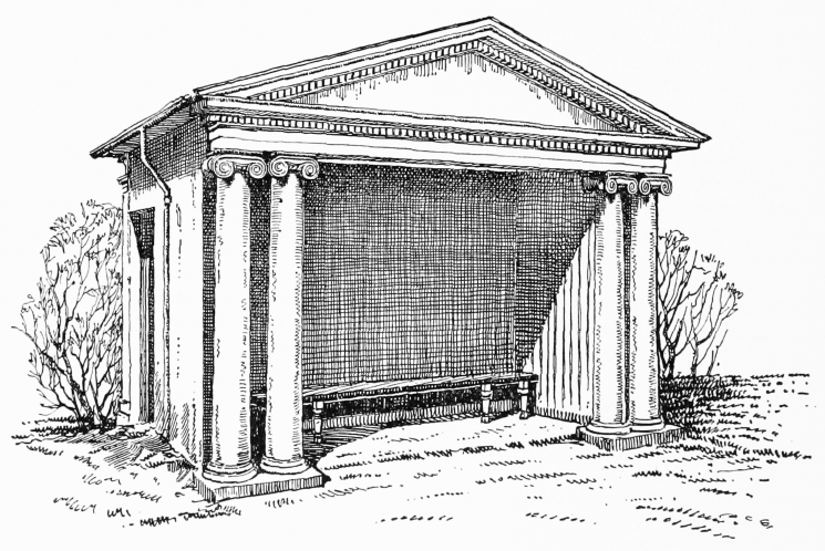
In 1822 the Trustees put up a garden seat, with £100 given for this purpose by the Duke of Northumberland. Nash supervised the work and probably designed the seat, which is doubtless the pedimented wooden structure which still stands in the garden (fn. 146) (fig. 4).
In the same year, 1822, the Trustees decided to have the roadway on the south side of the square macadamized. They were attended by James Macadam, who explained 'his principles of Road making', and in 1823 the Trustees decided to extend this resurfacing to the whole roadway, engaging Macadam to supervise the work at £40 per annum for five years. (fn. 147)
Since their earliest days the Trustees had been worried by the dustiness of the square and had carefully provided for it to be swept and thereafter watered 'as the Dust etc dos begin to fly'. The new surfacing did not solve this problem and Macadam had to be told that his arrangements for watering the square were insufficient. (fn. 148)
Nash's plantation was evidently of shrubs only, and in 1825 the Trustees decided to introduce 'a few Forest Trees'. Limes and laburnums were ordered to be planted. (fn. 149)
The plantation perhaps made the basin retained at its centre more dank than decorative, and by 1853 The Builder was reporting complaints about the 'scrubby wilderness'. (fn. 150) The following year the basin was filled in. (fn. 151) In Dasent's opinion (fn. 152) 'one of our periodical panics of cholera' contributed to the decision. (fn. 31)
When assuming ownership of the statue in 1911 the Office of Works had suggested to the Trustees that 'some arrangement should be made by which the statue could be viewed from the various roads converging on the Square', and that the garden should be 'suitably bedded out with flowers in the Summer'. The improvement of the garden was also suggested at the same time by some of the clubs in the square; (fn. 153) a request by one of the clubs for the formation of tennis courts was re- fused. (fn. 154) In the following year plans were made for the paths to be rearranged to give four straight approaches to the central space surrounding the statue. (fn. 155) This was not, however, carried out until after the war of 1914–18, during the last year of which a hostel for American officers was erected in the garden by the Y.M.C.A. of America. (fn. 156) In 1921 a report seems to have been obtained from Sir Edwin Lutyens by Mr. Gaspard Farrer, (fn. 157) who occupied No. 7, and in 1922–3 Mr. Farrer was instrumental in having 'extensive alterations' made, (fn. 158) when the approaches to the statue were straightened, and flowering trees planted. (fn. 159)
In May 1923 The Times commented appreciatively on the improvement, compared with the 'thicket of grimy shrubs' of 1913. 'What authority has done is to restore the ancient openness and keep the amenity of a garden. Many big trees have been cut down. Shrubberies have been uprooted and wide lawns laid out. Magnolias and other flowering things ring the circuit. There is space, light, grateful shadow, gentle grandeur. (fn. 160) From then until 1940 Mr. Farrer paid for the upkeep of the garden.
In 1922 the Trustees made keys of the garden available to the occupants on the south side of the square, (fn. 161) and in 1933 the garden was opened to the public at lunch-time during August: (fn. 162) the period of public use has since been extended.
Since the reshaping of the garden the chief alteration in the aspect of the centre of the square has been caused by the use of the roadway as a carpark. (fn. 32)
Garden seat, St. James's Square. Re-drawn from a photograph in London County Council collection
The original social character of the square has indeed been totally transformed. It is now not easy to realize how intensely aristocratic the square was in its early days. This character it retained in modified form into this century, but it was perhaps in its first fifty years or so of existence, before the great extension of fashionable London westward and northward, that it was most remarkably the centre of political and social eminence. When in 1682 the Duke of Ormonde was given an English dukedom and bought a house in the square his son congratulated him on the purchase, remarking 'how ill it would look now you are an English Duke to have no house there'. (fn. 163) The strong representation of eminent statesmen in the square in 1697 and 1721 has already been noticed: in the latter year no fewer than six dukes lived there— Chandos, Dorset, Kent, Norfolk, Portland and Southampton—as well as seven earls, a countess, a baron, a baronet, three untitled gentlemen (one of whom became Earl of Wilmington and another Viscount Palmerston), a baronet's widow and the widow of a French marquis. It was particularly in its first fifty years or so that the political significance of the square as a place of residence was reflected in the large number of embassies housed there. By 1732, at least ten of the houses had accommodated diplomatic envoys. (fn. 33) In about 1682 and again about 1716–18 the square contained three embassies simultaneously. (fn. 34)
From the middle years of the eighteenth century the political importance of the square's residents was rather less, but the general social distinction remained. Perhaps the first 'merchant' to take a house in the square was Sir Richard Child who lived at No. 5 from 1704 to 1711, and a dozen or so occur in the square during the eighteenth century. A notable intrusion was Wedgwood's showroom which occupied No. 8, on the corner of York Street, between 1797 and 1829. From 1807 to 1816 the Union Club occupied No. 21, but in the main the residential character of the square was little altered until about 1830. In the succeeding quarter of a century, however, ten of the houses ceased to be occupied as private residences, eight of them changing their character in the decade 1836–46, and by 1844 The Builder (fn. 164) could observe that the square was 'rapidly losing caste' following the introduction of club-houses and the removal of fashion to Belgrave Square. (fn. 35) Business houses, government offices and lodging-houses were also appearing, and by 1857 the three principal sides of the square contained a bank, an insurance society, two government offices, the London Library, two lodging-houses and three clubs. Side by side with these, however, the private houses retained their former character. The Builder of 1876 could remark that the square 'still remains the most aristocratic square in London' and cite Disraeli that it might 'be looked upon as our Faubourg St. Germain'. (fn. 165) When Dasent published his history of the square in 1895 he prophesied that 'the old Square, although no longer exclusively composed of private houses, will continue to maintain its ancient fame for many years to come'. (fn. 166) At that time ten private residences survived, and the only business houses were the bank and insurance society which had been established in the square since the mid-century. Thirty-five years later Messrs. Hampton and Sons, when unsuccessfully offering Norfolk House for sale in 1930, were still able to describe it as 'eminently suitable for a Nobleman's Town House . . . or for a Club, Embassy or Colonial Office' and to emphasize its convenience as an ambassadorial residence with adjacent chancery close to the Court of St. James. But they also noted that it 'provides a Site for Commercial Purposes' (fn. 167) and when the site was finally sold in 1937 the house was demolished to allow the provision of office accommodation, which by then was the square's chief function. In 1939 only Nos. 4–7 and 11 were privately occupied. The number of sites occupied by business premises on the three main sides had increased to nine. At present (1960) about a dozen of the original sites are occupied for business purposes, and only two clubs remain compared with seven in 1939. Four houses are occupied by the Ministry of Labour. A single house is occupied mainly as a private residence, No. 5, in the north-east corner.
This part of the square seems to have been characterized by length of tenure, and the families owning and occupying Nos. 4, 5 and 6 were neighbours for nearly two centuries, from 1712 until early in this century. They, together with the owner-occupiers of Nos. 2, 19, 20 and Norfolk House, constituted a group of seven families who resided together in the square for 120 years from 1771 to 1891.
In the eighteenth and early nineteenth centuries particularly there were some notable instances of personal continuity among the inhabitants: the earliest years of the square, though socially distinguished, saw fairly frequent changes of ownership and occupation, and by the midnineteenth century institutions were intruding into the square. But in between there were long years when many of the private residents did not change. For the sixteen years from 1724 to 1739 eleven of the residents remained unaltered, (fn. 36) including seven adjacent neighbours. For thirty-one years, from 1742 to 1773, the Duke of Cleveland, Lord Bathurst and the Duke of Leeds lived side by side at Nos. 19–21. For twenty-seven years, from 1807 to 1833, five adjacent neighbours were unchanged : (fn. 37) for twenty of these years seven immediate neighbours remained unaltered. (fn. 38)
The end of the first half-century of the square's history, bringing with it a rather greater continuity in the ownership and occupation of houses, initiated a further fifty-year period during which more than half the houses in the square were rebuilt. (fn. 39) The original construction was not uniformly of the best and some of the houses may have been becoming dilapidated. At the same time an increased stability of tenure would naturally be accompanied by a greater readiness to undertake the trouble and expense of rebuilding. But changing architectural taste, bringing a desire for a more sophisticated plan and a more modish appearance, was doubtless a stronger motive. It is noteworthy that by 1715 when Leoni published the first volume of his edition of Palladio interest in this more codified expression of taste was sufficiently general in the square for seventeen of twenty-one known residents to become subscribers. (fn. 40) The architectural character of the rebuilding between 1726 and 1754 was not, however, very strongly marked, and the square retained a considerable measure of uniformity, with unelaborated façades in various shades of brick dressed with stone: the circumstances of the rebuilding of the Halifax House site in 1726 raise, rather unexpectedly, the question whether regard for the unifying control sought to be exercised by the Crown in 1665 still affected the manner of new building. Some of the architects or builders employed at this time have not been identified but those known do not, in fact, seem to include the most modish of the Palladians. The solid Palladian virtues of Matthew Brettingham, however, won him considerable employment in and near the square.
The exterior modesty concealed an interior splendour, and the frescoes and architectural paintings of some of the best French and Italian artists were introduced into the square, partly supplanting the older fashion of wainscot, tapestry and gilt hangings. At No. 7 Louis Laguerre and Dutch decorative painters adorned the house for Lord Radnor, whilst the fashion for Venetian wall painting was reflected in the work carried out for the Duke of Portland, between 1710 and 1719, by Pellegrini or Ricci, for the Duke of Chandos between 1720 and 1722 by Bellucci, and for the Earl of Tankerville in about 1730 by Amigoni and Brunetti. All of this work has vanished. A similar taste for Italian work was shown in 1736 at No. 10 where Sir William Heathcote was willing to pay for the plasterwork of his staircase to be executed by an Italian stuccoist.
Bowles's view of c. 1752 (Plate 130), although not wholly accurate, shows the appearance of the square at that time, lacking its original uniformity but still mainly unostentatious in its outward aspect. As late as 1776 Sir John Fielding summarized the chief characteristics of the square which had pleased earlier eighteenthcentury critics and also the underlying attitude which relished its outward plainness: 'St. James's Square is beautiful and spacious. . . . Although the Appearance of the Square hath an Air of Grandeur, yet that by no Means resulteth from the Pomp and Greatness of the Structures about it; but rather from a prevailing Regularity throughout, joined to the Neatness of the Pavement. The Bason in the Middle contributes not a little in producing the Effect. The Houses are built more for the Convenience of their opulent and noble Possessors, than for causing Surprize in the Beholders.' (fn. 168) By the time this was written, however, a significant break had been made in the regularity of the square, with the erection in 1764–6 by James Stuart for Thomas Anson of No. 15, with its stone façade forming a more individual and assertive unit than earlier rebuildings. In the next decade brick was replaced by stucco or stone also at Nos. 11 and 20 by Robert Adam and probably at Thomas Brand's house by Sir William Chambers, although the latter change, if it took place at this period, was caused by no lack of appreciation of the brickwork on the part of the architect. The homogeneity of the square was thus impaired. (fn. 41)
For the first century or so of its history the square is not known to have been associated very closely with the most fashionable names in English architecture. But thereafter two of the architects most widely employed by the aristocracy, Adam and Soane, worked quite extensively in the square, although the frustration or reconstruction of their designs has prevented this being apparent. In the 1770's Adam built or refaced the exteriors of Nos. 11, 20 and 33 and produced an unexecuted design for No. 14: he also worked on the south side of the square. No. 20 remains, as the nucleus of a modern building, but at Nos. 11 and 33 his preservation of the earlier carcase, and later alterations, have made his work difficult to recognize. Between 1795 and 1823 Soane, besides being employed to make surveys of Nos. 8, 15 and 18, altered the façade of No. 21, built the Charles Street extension of No. 33 and carried out internal extensions and reconstructions at these two houses and at No. 3. He also made unexecuted plans for Samuel Thornton's house and supervised its repair. All this has disappeared except the Charles Street front of No. 33, which has been altered. The later phase of Soane's work at Nos. 3 and 33, after the ending of the French war, was coincident with a good deal of important building activity in the square: John Field rebuilt No. 6 and the Cockerells No. 32, while some work by Robert Abraham was introduced into Norfolk House. (fn. 42)
The 1830's and 1840's saw the rebuilding or refacing of Nos. 12 and 18 and the building of the Army and Navy club-house. But the half-century from 1847 to 1896 was a period of comparatively little important outward change. The clubs housed on the three principal sides of the square, many of which were short-lived, did not in general reconstruct their premises, which remained outwardly domestic, and during this period the only intrusion of obviously institutional architecture was the East India United Service club-house. Nos. 5 and 8 were refaced in stone or stucco, but the appearance of the square was not drastically altered. The small scale and irregular aspect of the south side of the square was, however, greatly changed by the building of the Junior Carlton club-house.
In 1896–8 the rebuilding of the London Library and No. 19 gave the west side of the square, already partly reshaped, a predominantly undomestic appearance. The building of the new Cleveland House, at No. 19, with a higher and more assertive roof-line than any previous building, was perhaps the first redevelopment wholly to disregard the existing character of the square. But the north and east sides remained until 1930 outwardly unbroken ranges of aristocratic town houses.
The square was still of sufficiently tranquil aspect in 1899 for the Trustees to be disturbed by Lady Strafford who 'continually used the Square for Cycling'. There was nevertheless a good deal of through-traffic which the present use of the roadway as a car-park has obstructed, and in 1910 the District Surveyor, when recommending the widening of John Street, spoke of 'the large amount of fast traffic which passes through the Square to Victoria via Pall Mall'. (fn. 169) In 1914 the present appearance of the square was foreshadowed when a resident complained to the Trustees of 'the increasing use of the Square as a standing place for motors'. (fn. 170)
The transformation of the square to its present visual character was effected chiefly between 1933 and 1939, with the rebuilding in a radically new manner of Nos. 3, 8 and Norfolk House, and the aggrandizement of the façade of No. 20 over two sites. A similar radical rebuilding has since been carried through on the site of Nos. 1–2, and only the range of building between Duke of York Street and the north-west corner of the square retains as yet the scale of large but private residences.
The redevelopment in the 1930's was marked by a notable increase in the height of building, coupled with a reduced and uniform floor-to-floor height occasioned by the use of sites to provide office accommodation. This increase in height and reduction in architectural scale, appearing on the south side also in the accretions to the roof of the Junior Carlton club-house, has brought about a visual transformation which the retention of some of the stylistic elements of seventeenth- and eighteenth-century architecture has not counteracted. The only restriction of height which could then normally be enforced was the eighty-foot limit (exclusive of two storeys in the roof) imposed by section 51 of the London Building Act of 1930, (fn. 171) modified by the system of angular measurements made in relation to adjacent open spaces, prescribed in section 44 of that Act. Both the Junior Carlton Club and No. 3 exceeded this height but their very juxtaposition to the square was held to justify this. Comment on the new building at No. 3 recognized that its height was determined by the need to obtain an adequate rental from the development of this 'costly site', and fears were expressed at the prospect of the piecemeal and out-of-scale rebuilding of the square. In 1938 the application for permission to build the new Norfolk House higher than eighty feet was strongly pressed, and its rejection by the Minister of Health discouraged the pursuit of a similar application in respect of No. 8.
The rebuilding of Nos. 8, 21 and Norfolk House took place after the Town and Country Planning Act of 1932 (fn. 172) had made formal provision for attempts to preserve buildings of historical or architectural interest by local authorities, conditional upon ministerial approval of Town Planning Schemes, which became effective in the London area in May 1935. (fn. 173) The possibility of preserving old Norfolk House was considered, but it was not thought justifiable to take action which, under the provisions of the Act, would probably have occasioned a forbiddingly large claim for compensation. Dasent's observation in 1895 on the demolition of Cleveland House, that 'the intrinsic value of the site was too great to permit the retention of such a mouldering vestige of antiquity', was in substance still apposite. (fn. 174) Unlike Nos. 3, 8 or 21, however, Norfolk House was recorded in photographs and measured drawings before it was pulled down, and one room was removed to the Victoria and Albert Museum.
The London County Council's refusal to permit the new Norfolk House to be built higher than eighty feet did not rest on the visual relationship of the new building to its immediate environment or to the traditional roof-line of the square, although a general suggestion by the Minister of Health that in future such considerations might be found relevant was mentioned at the appeal. Among the considerations pressed were the undesirability of increasing the volume of traffic in central London (which also caused the Council to insist on the provision of a garage at Norfolk House) and the need to encourage the dispersal of 'development' over the whole county rather than its concentration in central London.
In 1960 perhaps a dozen houses still preserve in their aspect something of the square's ancient character. But with the rebuilding of Nos. 3, 8, 21 and Norfolk House before the war, and of Nos. 1–2 and 6 subsequently, none of the sides of the square has retained its wholly residential appearance. Under the Town and Country Planning Act of 1947 the powers of the Council, as planning authority, to control development have been increased. The sheer height of façades to the square is likely in future to be limited approximately to that of the older houses: this height has been respected in the rebuilding of No. 6. Building Preservation Orders have been placed on Nos. 5, 9–12, 18, 32 and 33, those on Nos. 5 and 9–10 having been confirmed by the Minister of Housing and Local Government.
The South Side of the Square
Since 1884 the properties on the south side of the square have been numbered consecutively with those on the other sides: previously they were numbered separately and incompletely, some bearing only a Pall Mall number. Until comparatively recently this row of buildings was formed mainly of the backs of properties facing Pall Mall: the frontages to the square and Pall Mall are still held in common and are architecturally conformable to each other. The plots here were formerly quite narrow. Until the building of the Junior Carlton Club in 1866–9 there were sixteen plots in this row, with an average width of some twentytwo feet.
As has been seen, an original intention in the 1660's had been to bisect this side of the square by a wide roadway from Pall Mall. The width of only sixty feet between that street and the square would, however, probably have prevented the building of large mansions comparable with those intended in the rest of the square, and from the beginning the houses here faced south. They can first be identified in the ratebook of 1670, when they were listed in Pall Mall.
In 1734 Ralph called the south side of the square 'scandalously rude and irregular'. (fn. 175) That the frontage of this side was left partly unbuilt is shown in Rocque's map of 1746 and Zachary Chambers's of 1769, and still so appears in Horwood's map of 1795. Some buildings fronting the square, presumably of very humble appearance, were erected in the eighteenth century on shallow sites at the back of the Pall Mall houses. (fn. 176) John Gwynn's London and Westminster Improved of 1766 contained a suggestion for the entire removal of this row of buildings to open the square towards a proposed palace on the south side of Pall Mall. (fn. 177) The suggestion to remove the south side was repeated from time to time and was renewed by The Builder in 1851. (fn. 178)
When the residents on the three principal sides of the square had obtained their Act to finance the upkeep of the square in 1726 the south side was excluded from its operations: the residents there were not rated or entitled to serve as Trustees under the Act. The doors, bow windows, areas and coal-shoots made on the south side were regarded as 'encroachments' by the Trustees, who tried to exact payment for the privilege of opening communication into the square; with what success is not known. (fn. 179) From time to time counsel's opinion was sought. (fn. 180) In 1766 the Trustees were evidently charging for such encroachments at 2s. 6d. per foot frontage of the property. (fn. 181) The house built at that time by Adam for Andrew Millar in Pall Mall (see page 325) was given a plain back to the square, with a central opening in which provision was evidently made for the insertion of a doorway if this proved practicable. (fn. 182)
In 1809 the Trustees gave permission for the inhabitants on the south side to pave a footway before their houses and set up lamps: (fn. 183) it is not known whether this was in fact the first time a pavement was laid here. After gas-lamps had been installed in the square the Trustees agreed to place one on the south side as soon as the occupants there set up four lamps themselves. (fn. 184) At that time the Trustees were particularly concerned at the aspect of the south side, where some of the inhabitants had opened shops and exhibited trade signs. (fn. 185)
At the west end Alexander Adair had a large house with a bow window on to the square (see page 327). He subscribed towards the cost of Nash's plantation of the centre of the square and was the only occupant on the south side to be given a key to the enclosure. (fn. 186) It was not until 1922 that keys of the garden were made generally available to occupants on the south side. (fn. 187)
The irregular aspect of this side must have contrasted piquantly with the greater houses around the three principal sides. At No. 29, built in about 1820 and demolished in the 1930's, a small balconied front (Plate 197b) looked on to the square. (fn. 188) The building of the Junior Carlton Club in 1866–9 and its extension in 1885–6 transformed half this side of the square, and the subsequent merging of adjacent plots has increased the size of the building-unit. In this century the frontages to the square have been reconstructed with more architectural pretension, and now have an appearance consonant with that of the Pall Mall frontages and not very different from that of the more recent buildings on the principal sides of the square.
Mason's Yard and Babmaes Street
Since 1937 Babmaes Street has been the name of the street previously called Wells Street and of the yard to which it leads from Jermyn Street, previously called Babmays (corrupted to Babmaes) Mews.
Mason's Yard and Babmays Mews were laid out on the St. Albans freehold at the same period as St. James's Square, on two plots of ground each 200 feet square. From the first they were intended as stable yards for the houses built on the St. Albans freehold (fn. 189) and were known as the West and East Stable Yards respectively. The parts adjacent to the backs of houses in the square were held with those houses, but neither stable yard communicated directly with the square.
Access to West Stable Yard was principally from Duke Street (where Ogilby and Morgan's and Blome's maps show a single entry and Strype in 1720 (fn. 190) mentions the two entries that exist today), and by a narrow passage from Ormond Yard, which also still exists. Part of the yard was held in the late seventeenth and early eighteenth centuries with St. Albans (later Ormonde) House: (fn. 191) possibly for this reason Blome in c. 1689 and Strype in 1720 named it St. Albans Mews. It was called Halburn Yard Mews by Rocque and Hacburny Mews by Zachary Chambers (fn. 192) in 1769, while the ratebooks called it Ormond Yard until about 1790.
By 1740, however, it was already being called Mason's Stable Yard. (fn. 193) The owner of two houses fronting both Duke Street and the yard was at about that time Henry Mason. (fn. 62) He was presumably the licensed victualler of that name who had bought a stable in the north-east corner of the yard from the representatives of the St. Albans interest in May 1730. (fn. 194) There had been occupants of premises in the yard named Henry or William Mason back to 1717, (fn. 66) and the present name doubtless derives from that family. (fn. 43)
The stables here were of some consequence and in 1748 the London Evening Post reported the death 'at his House in Duke-Street' of a Mr. Margison 'who for several Years kept the great Stable-Yard in that Street call'd Mason's Mews'. (fn. 195)
In 1772 a house in the yard was in use as an 'Accademy or School' in the tenure of a Mr. John Paterson. (fn. 196)
Ogilby and Morgan's map of 1681–2 and Blome's of c. 1689 show that the general form of Mason's Yard has remained unaltered throughout its history, the central isolated block of building having existed from the beginning. A rebuilding of this block was carried out by Benjamin Timbrell in 1728. (fn. 197)
The East Stable Yard, unlike the West, was approached by a fairly wide street called Wells Street, linked with Piccadilly by Eagle Street. Wells Street, which was not part of St. Albans's freehold, first appears under that name in the ratebooks in 1671. It was presumably laid out by John, George or Francis Wells, the first a victualler of St. Marylebone and the others perhaps a bricklayer and a carpenter. (fn. 198) The yard itself by the time of Rocque's map was called Babmay's Mews, a name clearly deriving from Baptist May. Rocque's and Zachary Chambers's (and earlier) maps show this as an open rectangular yard. Rhodes's map of 1770 (fn. 199) shows an isolated block in the centre and by the time of Thomas Chawner's map of 1794 (fn. 200) the open space had been reduced approximately to its present form.
Until recently both Mason's Yard and Babmaes Street were used in part for the modern equivalent of their original purpose. Babmaes Street had been almost wholly transformed in appearance, and the centre of the former Babmays Mews is now being rebuilt as offices with a garage in the basement. Mason's Yard continues to be used partly as garages and preserves a little of the general aspect of an old stable yard.