Survey of London: Volumes 29 and 30, St James Westminster, Part 1. Originally published by London County Council, London, 1960.
This free content was digitised by double rekeying. All rights reserved.
'Pall Mall', in Survey of London: Volumes 29 and 30, St James Westminster, Part 1, (London, 1960) pp. 322-324. British History Online https://www.british-history.ac.uk/survey-london/vols29-30/pt1/pp322-324 [accessed 26 April 2024]
In this section
CHAPTER XVII
Pall Mall
The street now known as Pall Mall was laid out in its present position in 1661, on the site of the old pall mall alley (see page 24). It replaced the ancient highway which until then had led from Charing Cross to St. James's Palace along a line roughly parallel with, but south of, the present street (fig. 58). The present Warwick House Street formed the eastern extremity of this ancient highway which, to the west of the palace, continued along what is now Cleveland Row and thence across the fields which are now Green Park to Hyde Park Corner. Its course is shown on Faithorne and Newcourt's map, published in 1658 (Plate 1).
No evidence has been recorded to suggest that this highway was a Roman road but, as the westward continuation of the Strand, it was probably in existence in Saxon times. (fn. 3) References to the highway occur in documentary sources from the twelfth century onwards, (fn. 4) chiefly in connexion with St. James's Hospital which lay on its south side. When Henry VIII laid out St. James's Park a boundary wall was erected along the south side of the highway (Plate 1) and this later served to define the boundary of St. James's parish. (fn. 5) Between the wall of the park and the road there was apparently a strip of waste land, for in 1620 the High Sheriff of Middlesex was ordered to remove 'divers base sheddes and tentes sett up under St. James Park wall betweene Charinge Chrosse and St. James House, . . . whiche are all offensive and noe way fitt to be suffered to stand'. (fn. 6) A few months later the vestry of St. Martin's parish gave instructions to the churchwardens 'to Levell the ground adioyning to St. James wall where the Tents were pulled downe and as soone as conveniently may be make a new paire of Butts in the place where the ancient Butts did stande'. (fn. 7) Shortly after the Restoration a new pall mall alley was laid out within St. James's Park on the south side of the park wall, but the dust from the coaches travelling along the old highway blew over the wall and proved Very troublsom to the players at Mall'. (fn. 8) In July 1661 posts and rails were therefore set up 'to barre up the old way', (fn. 9) and by September a new road on the site of the old pall mall alley (from which it took its name) had been railed in and opened to public use.
During the development of Pall Mall Field in the 1650's a row of houses (C on fig. 58) had been built along the southern fringe of the field bordering the north side of the old highway. As a result of the opening of Pall Mall these houses lay on the south side of the new road, and in a petition addressed to the King in 1664 the tenants stated that their houses had been 'built applicable to it [the old road] and cannot be turned without great damage and charge'; they went on to request that a grant of the site of the old road might be confirmed to them 'to augment their gardens'. (fn. 10) This request was successful, for in April 1665 the Earl of St. Albans's trustees received a sixty-year lease of the greater part of the site of the old highway in order that they might grant sub-leases to the tenants. (fn. 11)
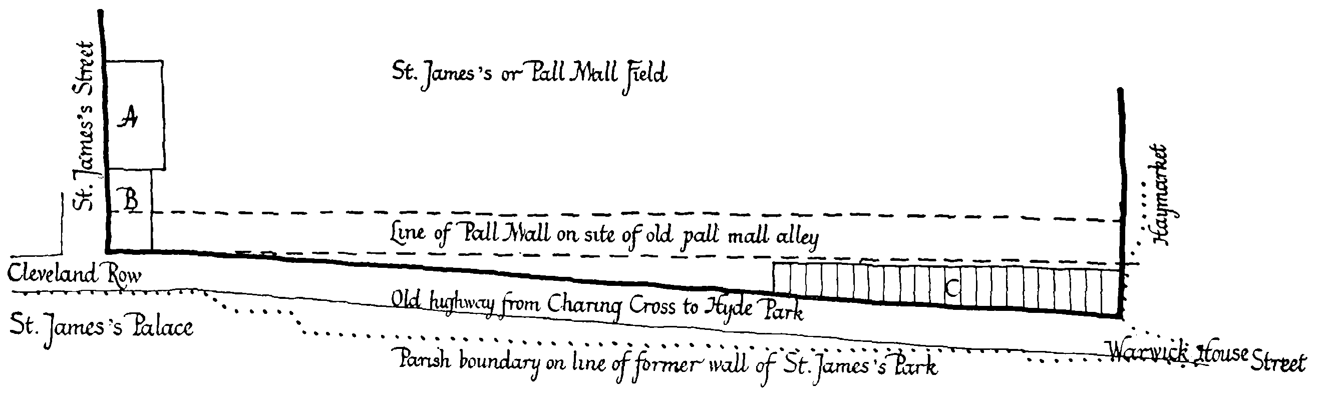
The old highway from Charing Cross to St. James's Palace, stopped up in 1661, and the old pall mall alley (now Pall Mall). Not to scale A. Physic Garden. B. Tennis court, c. Houses on the north side of the old highway
Other parts of the old highway were granted to Sir Philip Warwick (later the site of Warwick House, Warwick House Street, see page 427), and Sir John Denham (later incorporated into the grounds of Marlborough House); that part between St. James's Palace and the tennis court was built over (see below), and another part was given to the Duchess of Cleveland and became the site of Nos. 8–12 Cleveland Row and Stornoway House (see pages 504–5).
The western section of the old highway was probably closed in 1668 when the fields through which it led were enclosed to form what is now Green Park. Ogilby and Morgan's map of 1681–2 (Plate 2) shows the road terminating abruptly at the edge of the park.
In 1662 Pall Mall was included among several streets 'thought fitt immediately to be repaired new paved or otherwise amended', and was placed under the control of paving commissioners appointed by an Act of Parliament. (fn. 12) The commissioners, one of whom was the Earl of St. Albans, (fn. 13) were empowered to remove encroachments and to offer compensation for the removal of any buildings which had stood for thirty years or more. (fn. 12) Two such buildings were the old tennis court and the house attached to it (see page 25), which must have almost blocked the west end of the new street (B on fig. 58), and in 1664 the commissioners notified Martha Barker, the then owner of the Crown lease, that they 'thought fitt to have it [the tennis court] taken down to enlarge the said way'. She was offered £230 as compensation but was unwilling to accept, and her under-tenant, Robert Havercampe, claimed that satisfaction should be offered to him, as he had already lost custom to the value of a hundred pounds through rumours of the impending demolition of the court. (fn. 13) The tennis court was eventually cleared away in or before 1679, thus opening up the west end of Pall Mall. (fn. 14)
About 1680 several houses and shops were built on part of the ground originally let with the tennis court and on part of the disused highway which separated it from the front of St. James's Palace. (fn. 15) These buildings, one of which became Ozinda's chocolate house, were erected in line with the frontage of the other houses on the south side of Pall Mall. They are shown on Rocque's map (Plate 5) immediately to the north of St. James's Palace and on the west side of the passage marked 'Fryery'. They were demolished in 1748 (fn. 16) and the site laid into the roadway in front of the palace. (fn. 17) Subsequently the frontage of the palace at this point was extended forward; the old frontage line is marked by the boundary plates of the parishes of St. Martin and St. James on the east wall of the palace.
Between 1814 and 1818 the narrow eastern extremity of Pall Mall was widened in connexion with the improvement of the Opera House; a row of houses on the north side between Market Lane (now occupied by the Royal Opera Arcade) and the Haymarket was demolished. (fn. 18)
In 1928 the gateway to Marlborough House was set back to its present position (see page 383); it had previously stood in line with the fronts of the adjoining houses on the south side of the street.
At the beginning of the eighteenth century Pall Mall was 'the ordinary Residence of all Strangers, because of its Vicinity to the Queen's Palace, the Park, the Parliament-House, the Theatres, and the Chocolate and Coffee Houses, where the best Company frequents'. (fn. 19) In 1720 John Strype described it as 'a fine long Street. . . . The Houses on the South side have a Pleasant Prospect into the King's Garden; and besides, they have small Gardens behind them, which reach to the Wall [of St. James's Park] and to many of them there are raised Mounts, which give them the Prospect of the said Garden, and of the Park.' (fn. 20) By 1764, however, the beauty of the street was said to be 'greatly disfigured by several mean houses of the lowest mechanicks being interspersed in it in many places, and many of them joining to the most sumptuous edifices'. (fn. 21) This contrast persisted into the early nineteenth century, when Charles Oilier described Pall Mall as a 'stately aristocraticlooking street' with 'private mansions fit for the residence of the wealthy and noble' but at its east end 'bordered with filthy alleys, inhabited by abandoned characters'. (fn. 22)
With the abolition of St. James's Market and the formation of Regent Street the architectural contrast in modern Pall Mall is no longer between the east and west ends of the street, but between the north and south sides. In general the buildings on the south side, with their prospect towards Carlton Gardens and St. James's Park, have always been on a grander scale than those on the north, but the difference is also partly attributable to the ownership of the land on the two sides of the street. With the one exception of the site of No. 79 Pall Mall, (fn. 1) the freehold of all the ground on the south side belongs to the Crown, and ever since the tightening up of the administration of the Crown lands by John Fordyce in the last decade of the eighteenth century, the granting of leases and the design and maintenance of buildings has been closely supervised by successive bodies of commissioners acting on behalf of the Crown. But on the north side of the street the freehold of all the ground between St. James's Street and the east side of St. James's Square was granted by the Crown to the Earl of St. Albans's trustees in 1665 (see fig. 3) and subsequently passed to a number of private individual owners, (fn. 1) The result has been that in general the buildings have narrow frontages and are of inferior design to those on the south side. To the east of the east side of St. James's Square the freehold of this ground on the north side of the street still belongs to the Crown; a number of the buildings here form the return fronts of those in Waterloo Place, and their design has been dictated by the need for harmony with that street.
A list of distinguished residents and lodgers in Pall Mall whose names are not mentioned in connexion with individual buildings in Chapters XVIII to XXI is contained in the Appendix.