Survey of London: Volumes 33 and 34, St Anne Soho. Originally published by London County Council, London, 1966.
This free content was digitised by double rekeying. All rights reserved.
'Estate and Parish History', in Survey of London: Volumes 33 and 34, St Anne Soho, ed. F H W Sheppard (London, 1966), British History Online https://www.british-history.ac.uk/survey-london/vols33-4/pp20-26 [accessed 30 April 2025].
'Estate and Parish History', in Survey of London: Volumes 33 and 34, St Anne Soho. Edited by F H W Sheppard (London, 1966), British History Online, accessed April 30, 2025, https://www.british-history.ac.uk/survey-london/vols33-4/pp20-26.
"Estate and Parish History". Survey of London: Volumes 33 and 34, St Anne Soho. Ed. F H W Sheppard (London, 1966), British History Online. Web. 30 April 2025. https://www.british-history.ac.uk/survey-london/vols33-4/pp20-26.
In this section
CHAPTER I
Estate and Parish History
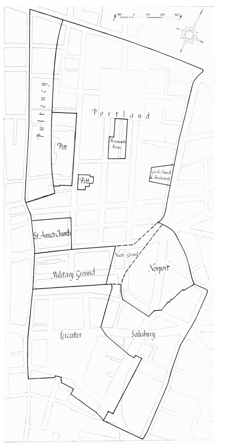
Volumes XXXIII and XXXIV of the Survey of London describe the parish of St. Anne, Soho, which was formed out of part of the parish of St. Martin in the Fields in 1686 (fig. 1). The ground on the east and south sides of Leicester Square, which was never in the parish of St. Anne, has also been included in order to present a complete account of the Leicester estate, of which it formed part.
The Northern Part of the Parish
The area to the north of Shaftesbury Avenue was bounded on the north by Tyburn Road (now Oxford Street), on the east by Hog Lane (later Crown Street, now Charing Cross Road), on the south by the road from St. Giles's towards St. James's (later King Street, now Shaftesbury Avenue) and on the west by Colman Hedge Lane (now Wardour Street). This area was known in the sixteenth century as St. Giles's Field (see the plan of 1585 reproduced on Plate 1a). The greater part of this ground, later called Kemp's Field and Bunch's Close or Soho Fields, belonged in the Middle Ages to the Master of the Hospital of Burton Saint Lazar in Leicestershire, who was custodian of the leper hospital of St. Giles in the Fields. The remainder, a long narrow strip on the east side of Colman Hedge Lane, belonged to the Abbot and Convent of Abingdon. In 1536 the lands of both the Master of the Hospital of Burton Saint Lazar and of the Abbot and Convent of Abingdon were surrendered to Henry VIII for the formation of a royal park for the Palace of Whitehall, and later became part of the Bailiwick of St. James. (fn. 7) (fn. 1)
The whole of the Bailiwick of St. James was subsequently given by Charles I to Queen Henrietta Maria. After the Restoration Henry Jermyn, Earl of St. Albans, who had accompanied Henrietta Maria into exile in France in 1644, became possessed of Soho Fields and other lands within the bailiwick by successive grants from the Queen and from Charles II for a term expiring at Michaelmas 1734. (fn. 8) In 1673 St. Albans and his trustees leased nineteen of the twenty-two acres of Soho Fields to Joseph Girle of St. Marylebone, brewer, (fn. 9) who three years later obtained a royal licence to build there. (fn. 10) In 1677 Girle disposed of both his lease and his licence to Richard Frith, citizen and bricklayer of London, (fn. 9) who with a number of associates was responsible for building development here (see Chapter II). In 1698 William III granted the Crown freehold of the greater part of this area to William, Earl of Portland. (fn. 11) The Crown freehold of most of the remainder, comprising land in Dean Street in which the Pitt family had had a leasehold interest, was disposed of in 1830 by exchange for other lands elsewhere in the West End of London, and by sale in 1833 (see Chapter IX). The only part of the nineteen acres retained by the Crown after 1833 was the site of Monmouth House on the south side of Soho Square, which was disposed of piecemeal, the last portion in 1955. (fn. 12)
The three acres of Soho Fields which were not included in St. Albans's lease of 1673 to Joseph Girle became, after an exchange, the site of St. Anne's Church (Chapter X) and of the Greek Church and St. Martin's almshouses in Crown Street (Chapter XI). The Crown freehold of the latter was granted in 1684 to Thomas, Lord Jermyn, in trust for the parish of St. Martin, to whose trustees he conveyed it in 1686; (fn. 13) the site is now occupied by the St. Martin's School of Art in Charing Cross Road.
To the west of Soho Fields lay the long narrow strip of ground referred to above, which until its surrender to the Crown in 1536 had belonged to the Abbot and Convent of Abingdon. The Abingdon lands continued to be held together for many years under leases granted by Henry VIII and his successors, but in February 1721/2 the freehold of part of these lands in Soho was conveyed to the trustees of the will of Sir William Pulteney, in whom the leasehold interest was then vested. (fn. 14) In 1830 the Crown disposed, by exchange, of some of its remaining land here to Sir Richard Sutton, who had inherited the Pulteney family estate. (fn. 15) The rest of this strip on the east side of Wardour Street, whose history is described in Chapter XII, is still in the possession of the Crown and is now vested in the Crown Estate Commissioners.
Estate boundaries in the late seventeenth century
The Southern Part of the Parish
The area to the south of Shaftesbury Avenue was bounded on the north by the road from St. Giles's towards St. James's (later King Street, now Shaftesbury Avenue), on the east by the road leading from St. Giles's Church to St. Martin's (later Upper St. Martin's Lane and West Street), on the south by the royal mews, and on the west by Colman Hedge Lane (now Whitcomb Street and Wardour Street). This area formed part of St. Martin's Field (see the plan of 1585 reproduced on Plate 1a). Its early history is not altogether clear, but the greater part of it (or possibly all of it) came into the possession of Henry VIII between 1536 and 1547. The previous owners included the Abbot and Convent of St. Peter's, Westminster, the Abbot and Convent of Vale Royal in Cheshire, the Abbot and Convent of Abingdon (?), John Digby and the Countess of Oxford (the latter as heiress to the ground previously held by the Beaumont family).
Most of these lands in the southern part of the parish only remained in the possession of the Crown for a very few years, and only two acres were ever described as being within the Bailiwick of St. James. In 1554 Queen Mary sold two portions, containing some seven acres in all, (fn. 16) and other Crown grants of the freehold were made in 1590 (fn. 17) and 1623. (fn. 18) The last piece of Crown land, consisting of two acres of the Military Ground, was granted by Charles II in 1676 to Charles, Baron Gerard, (fn. 19) who in the following year leased the whole of the Military Ground to Dr. Nicholas Barbon, the building speculator, and John Rowley, timber merchant (fn. 20) (Chapter XVI)—the only case within this area where the Crown grantee was in any way concerned in the subsequent development. Everywhere else in this southern part of the future parish of St. Anne there were intermediaries through whom the ownership of the ground ultimately coalesced to form (in addition to Gerard's Military Ground) three estates—that acquired by Robert Cecil, first Earl of Salisbury, in 1609 (fn. 21) and 1610 (fn. 22) (Chapter XIV), that acquired by Robert Sidney, second Earl of Leicester, in 1630 (fn. 23) and 1648 (fn. 24) (Chapters XVII–XXI) and that acquired by Mountjoy Blount, Earl of Newport, in 1634 (fn. 25) and 1654 (fn. 26) (Chapter XV). Part of the ground acquired by the Earl of Salisbury now belongs to the Salisbury Settled Estates, but the Sidney family's ground was sold at the end of the eighteenth century while that of Lord Newport was sold by his heir in 1682 to Dr. Nicholas Barbon, (fn. 27) who already held the lease of the adjoining Military Ground estate.
The Parish and Vestry of St. Anne
The lands which later comprised the parish of St. Anne had in medieval times been within the parishes of St. Margaret, Westminster, and St. Martin in the Fields. St. Martin's Field (the area to the south of Shaftesbury Avenue) had been partly in St. Margaret's and partly in St. Martin's, while further north a small piece of St. Giles's Field had also been in St. Margaret's parish. (fn. 28)
Henry VIII's westward extension of the Palace of Whitehall across the road from Charing Cross to Westminster resulted in the 1530's in travellers having to pass through the precincts of the palace, and the bodies of the parishioners of St. Margaret's who died in the part of the parish to the north and east of Whitehall had to be carried through the palace for burial at the parish church. In order to avoid risk of infection from the bodies of those parishioners who 'doe Dye of any Desease Pestilence Ague or any other Contagious Sickness', Henry VIII in 1534 directed the Abbot of Westminster that all 'Parishioners of Your Parish of St. Margarett dwelling within . . . St. Martins . . . by North & East Our said Mannor [i.e., the King's Palace of Whitehall] be Seperate . . . from the Parish & Parishioners of St. Margaretts & . . . from henceforth . . . taken for Parishioners of St. Martins'. (fn. 29) By letters patent of 1542 Henry VIII rearranged the boundaries of the two parishes, and transferred all the area between the Church of St. Clement Danes and the royal palace of Westminster, formerly part of St. Margaret's, to the parish of St. Martin in the Fields. (fn. 30) (fn. 2) Thus when the westward expansion of London in the latter part of the seventeenth century required the building of a new church for the Soho district, the parish of St. Anne was formed by detaching part of the parish of St. Martin, and St. Margaret's was unaffected.
The building of a new church in Soho seems to have been first contemplated in 1676 (see page 256), one year before Richard Frith began to develop Soho Fields. In February 1676/7 ten gentlemen from St. Martin's and the intended new parish of St. James met to discuss the bounds of that new parish, (fn. 31) which was also to be formed out of St. Martin's. By August 1677 the site of the new church in Soho had evidently been decided, for in that month trustees acting on behalf of St. Martin's parish exchanged the small piece of land in Soho Fields which the Earl of St. Albans and his trustees had leased to them in 1674 for two other pieces of ground which later became the sites of St. Anne's and of the Greek Church and St. Martin's almshouses (fn. 32) (see page 256).
In February 1677/8 the vestrymen of St. Martin's were meeting ('by seaven of the clock in the morning') to discuss the boundaries of the new parish intended for 'the Church now in building by the Bishopp of London in Kemps Feild' (i.e., Soho Fields), (fn. 33) and in March a Bill to establish the new parish was introduced into the House of Commons. (fn. 34) By this time the dedication to St. Anne had also been decided, (fn. 35) possibly as a compliment to the thirteen-year-old Princess Anne whose mentor was the Bishop of London.
This first Bill was sent to committee after its second reading in May, but no more was heard of it and in that month leave was given for the introduction of a second Bill with the same purpose, which received the royal assent on 15 July 1678. (fn. 36) The Act set forth the boundaries of the intended new parish and provided that this 'precinct' should become a separate parish on the Lady Day (25 March) following the consecration of the church. The inhabitants should then become subject to the general laws in force for the choice of churchwardens, overseers of the poor, surveyors of the highways and scavengers, the first of whom were to be chosen by the vestry of St. Martin shortly after the consecration of St. Anne's Church. At the same time the Westminster Court of Burgesses was to appoint constables and beadles and make rules for watch and ward. (fn. 37) The provisions in the Act for the completion of the church are described on page 259.
The establishment of the new parish and vestry depended upon the completion of the church. From 1678 to 1684 nothing is known about the progress of this work, but on 30 April 1685 Bishop Compton established a twelve-man commission to be 'supervisors of and for the building of the said church', and recommended that if there were not enough money for the church, the commissioners should seek statutory power 'to raise money of the Inhabitants and Owners' within the future parish. (fn. 38) Shortly afterwards the commissioners decided to act on the bishop's advice and on 3 June 1685 the House of Commons gave leave for a Bill to be brought in to 'build' the church at the cost of the inhabitants. (fn. 39) The Bill received the royal assent on 27 June. (fn. 40)
The Act directed the bishop within thirty days to appoint thirty 'of the best and most discreet Inhabitants in the said Precinct' to complete the church, and after its consecration to be (together with the rector and churchwardens) the vestrymen of the new parish, with power to fill vacancies as they occurred. (fn. 41) On 8 July 1685 Compton appointed this second commission, (fn. 42) which on 21 March 1685/6, the date of consecration of the church, (fn. 43) became the Select Vestry of the parish of St. Anne. (fn. 3)
In March 1741/2 a number of the principal inhabitants of the parishes of St. Anne, St. George, Hanover Square, St. James, St. Margaret and St. Martin in the Fields, all of which were governed by Select Vestries, presented a petition to the House of Commons protesting against the 'managing the Affairs of the said Parishes, exclusive of and without the Knowledge and Concurrence of, the rest of the Inhabitants.' (fn. 44) The petition was referred to a committee, but leave to bring in a Bill for the reform of Select Vestries was refused. (fn. 45) At St. Anne's, however, the reformers did not give up, and on 24 January 1743/4, when the Select Vestry was holding a meeting to fill vacancies caused by death, 'several other Inhabitants of this Parish came into the said Vestry Room and opposed their proceeding to an Election, asserting that there was no Select Vestry legally Constituted . . . but that all parish Business there ought to be done in an open or General Vestry'. The vestrymen decided to seek counsel's opinion. (fn. 46) What happened next is not clear—many years later the vestry clerk stated that 'certain inhabitants entered the vestry-room, and turned out the gentlemen who were acting as select vestrymen, and burnt their books' (fn. 47) —but by 21 May 1744 an Open Vestry, at which all ratepayers could attend, had taken over the management of the parish. (fn. 48)
This Open Vestry survived until 1855. Polls at which all ratepayers (including female ratepayers (fn. 4) ) were entitled to vote were frequently held, usually for the appointment of parish officers, but (although some 1,400 persons were qualified to attend and vote) the affairs of the parish were said in 1829 to have been conducted in an orderly manner. (fn. 47) After 1818 both the polls and the proceedings of the vestry appear to have been conducted under the system of plural voting established by the Act of that year (fn. 49) for the regulation of parish vestries, (fn. 47) but the vestry of St. Anne decided not to adopt the Act of 1819 (fn. 50) authorizing the establishment of Select Vestries for the management of the relief of the poor. (fn. 51) Hobhouse's Act of 1831 for the better regulation of vestries was not adopted at St. Anne's. (fn. 52)
The Act of 1855 which established the Metropolitan Board of Works provided that the vestry of St. Anne should in future consist of the rector, two churchwardens and twenty-four vestrymen, the latter to be elected by all ratepayers who had been assessed for the relief of the poor for at least one year. The Act also provided for the unification of the parishes of St. Anne, St. Paul, Covent Garden, St. Mary le Strand, St. Clement Danes, the Precinct of the Savoy and the Liberty of the Rolls, which together were to form the Board of Works for the Strand District. The members of the board were to be elected by the constituent vestries and liberties. (fn. 53)
The main functions of these local boards were the paving and cleansing of the streets, the maintenance of sewers (other than main sewers) and the making of minor street improvements. Under the provisions of the London Government Act of 1899 all the vestries and district boards of works ceased to exist, and their powers were transferred to the twenty-eight newly established metropolitan borough councils, of which the Westminster City Council was one. (fn. 54)
Watching
The history of the parish watch-house is described on page 276. Until 1736 the parish beadles and the unpaid constables had been responsible for the maintenance of law and order, but this arrangement had proved inadequate, and by five Acts of Parliament passed between 1734 and 1736 all the parishes of Westminster except St. Clement Danes and St. Mary le Strand obtained power to raise a watch rate and employ watchmen to guard the streets by night. One of these Acts, passed in 1736, recited that the beadles in the parish of St. Anne had proved to be 'of great charge and little use' and that the method of raising money to pay them had 'been also precarious and unwarrantable'. The Act therefore authorized the vestry to appoint watchmen and pay them out of a watch rate not exceeding sixpence in the pound. (fn. 55) In 1739 there were six constables, four beadles and twenty watchmen. (fn. 56)
In 1829 the parish watch came under the jurisdiction of the new Commissioners of Metropolitan Police.
Paving, Cleansing and Lighting
An Act of 1762 established commissioners for paving, cleansing and lighting the streets of Westminster and certain adjoining parishes. (fn. 57) By an Act of 1771 the Westminster Paving Commissioners' powers were considerably diminished, each vestry being authorized to elect a committee to supervise newly paved streets, except the so-called 'optional' streets where the occupants preferred to remain under the authority of the commissioners. (fn. 58) In 1783 another Act transferred the sole power to pave, clean and light all the streets in the parish of St. Anne (including the optional streets) to a twenty-one-man committee whose members were to be elected annually by the inhabitants in vestry assembled. There were also ten trustees, who had to have an estate worth at least £300 per annum, or personalty of at least £10,000, and who were to supervise the committee. (fn. 59) The streets were maintained under this Act until 1855, when responsibility was transferred to the Board of Works for the Strand District.
The Origin of the Name Soho
The Oxford English Dictionary defines the word Soho as 'an Anglo-French hunting call, probably of purely exclamatory origin', and cites examples of this usage from the early fourteenth century onwards. The first known use of Soho as a placename in this locality occurs in 1636, as a heading in a list of ratepayers in the parish of St. Martin in the Fields. (fn. 60) In October 1641 Anna Clerke, 'a lewd woman', was bound over to keep the peace after 'threteninge to burne the houses at So:ho', (fn. 61) and in September 1642 William Colley, yeoman, was accused of using foul language against Noah Cliffe, one of the parish constables, and of 'threateninge to burne the houses at Sohoe'. In the same month John Walker, yeoman, was arrested by Cliffe for 'quarrellinge at 3 of the clocke in the night at Soho'. (fn. 62)
A parliamentary survey of Crown lands made in 1650 describes 'the severall tenements situate at a place called So:ho' and makes it clear that they were on the east side of the modern Wardour Street and extended from Oxford Street southward to Bourchier Street. The southernmost of these houses, evidently at or near the north corner of Wardour and Bourchier Streets, was built of brick and tile and was valued at four pounds per annum. It contained three rooms below stairs, a chamber and garret above, and was 'commonly called or knowne by the name of So:ho'. (fn. 63)
The field at the north end of the west side of the modern Wardour Street was known in the seventeenth century as Doghouse Close, (fn. 64) and although no evidence of a canine association has been found, it is evident that hunting took place over the lands to the west of Wardour Street. The Lord Mayor and aldermen of the City of London used periodically to inspect the water conduits, including that leading 'from the Town of Tyburn [i.e., Marylebone] by Pipes of Lead into the City'. An account of one such expedition, in 1562, records that 'the Lord Mayor . . . Aldermen, and many worshipful Persons, and divers of the Masters and Wardens of the twelve Companies, rid to the Conduit Heads for to see them, after the old Custom: And, afore Dinner, they hunted the Hare, and killed her, and thence to Dinner at the Head of the Conduit [at the Lord Mayor's banqueting house, formerly on the site of Stratford Place]. There was a good Number, entertained with good Cheer by the Chamberlain. And, after Dinner, they went to Hunting the Fox. There was a great Cry for a Mile; and, at length, the Hounds killed him at the end of St. Giles's. Great Hallowing at his Death, and Blowing of Horns: And thence the Lord Mayor, with all his Company, rode through London to his Place in Lombard-street'. (fn. 65)
This evidence suggests that in the 1630's and 40's the name Soho denoted a particular house or group of houses, probably at the north corner of Wardour and Bourchier Streets, and was soon used to describe the range of adjoining houses extending as far north as Oxford Street. (fn. 5) By the 1680's the northern part of the street was also known as Wardour Street (from Edward Wardour, who owned ground on the west side), but the short stretch between Meard and Old Compton Streets is marked on Rocque's map of 1746 (Plate 4) as 'Old Soho'. This name was used by the rate collectors until 1841, when it was superseded by Wardour Street. Possibly the house described in 1650 as 'commonly called or knowne by the name of So:ho' was an inn used as a hunting rendezvous. (fn. 6)
In common parlance Soho now denotes the large area bounded on the north by Oxford Street, on the east by Charing Cross Road, on the south by Leicester Square and Coventry Street, and on the west by Regent Street; it thus includes part of the parish of St. James as well as almost all of St. Anne's. In the second half of the seventeenth century the greater part of the parish of St. Anne to the north of the modern Shaftesbury Avenue was known as Soho Fields, and after the completion of building development here this area was often referred to as Soho. But the parish was referred to throughout the eighteenth century as St. Anne's, Westminster, although in the second half of the century the church was sometimes called St. Anne's, Soho, presumably because of its proximity to the original area of Soho. By 1829 the parish was also being called St. Anne's, Soho, (fn. 47) and ten years later Soho was described as 'an extensive tract of ground, occupied by numerous streets in the neighbourhood of Leicesterfields, up to Oxford-street, and abutting on Golden-square on the western side'. (fn. 66)