A History of the County of Gloucester: Volume 4, the City of Gloucester. Originally published by Victoria County History, London, 1988.
This free content was digitised by double rekeying. All rights reserved.
'Medieval Gloucester: Topography', in A History of the County of Gloucester: Volume 4, the City of Gloucester, ed. N M Herbert (London, 1988), British History Online https://www.british-history.ac.uk/vch/glos/vol4/pp63-72 [accessed 30 April 2025].
'Medieval Gloucester: Topography', in A History of the County of Gloucester: Volume 4, the City of Gloucester. Edited by N M Herbert (London, 1988), British History Online, accessed April 30, 2025, https://www.british-history.ac.uk/vch/glos/vol4/pp63-72.
"Medieval Gloucester: Topography". A History of the County of Gloucester: Volume 4, the City of Gloucester. Ed. N M Herbert (London, 1988), British History Online. Web. 30 April 2025. https://www.british-history.ac.uk/vch/glos/vol4/pp63-72.
Topography
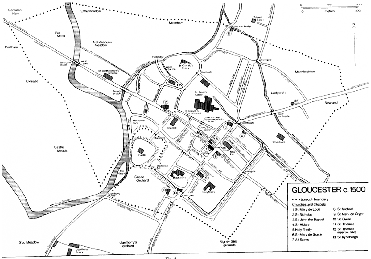
The basic plan of Gloucester owes much to its Roman origins, but its street pattern was laid down in the Anglo-Saxon period, with possibly a planned development in the early 10th century. (fn. 1) Infilling and suburban expansion continued throughout the 11th and 12th centuries. By the 13th century, when a clear picture begins to emerge from the documentary evidence, the town had already acquired the form that has its earliest visual representation in Speed's map of 1610; (fn. 2) with few exceptions, the streets and side lanes can all be traced in the 13th-century records. (fn. 3) Medieval Gloucester took shape, therefore, in centuries for which there is little written record and, until fuller archaeological evidence becomes available, its development must remain largely a matter for conjecture.
In the immediate post-Conquest period one of the most significant changes was the provision of stronger defences. (fn. 4) Using the foundations of the Roman walls and water from the southern branch of the river Twyver (also called the Full brook), a circuit of walls with gates and a moat was built to enclose on three sides the inner eastern part of the town. On the north side of the town two outer gates were built on the northern branch of the Twyver to mark the limits of the suburbs which had grown up in late Anglo-Saxon times on Hare Lane and along the London road. In the north-west part of the town the inner defences were provided by the precincts of Gloucester Abbey, which were walled and extended between 1104 and 1113 and again extended in the early 13th century, (fn. 5) and the precincts of St. Oswald's minister. In the south-west part of the town the defences were strengthened soon after the Conquest by the building of a castle, which involved the removal of several houses. The first motte-and-bailey structure, incorporating the mound later known as the Barbican, was replaced in the first years of the 12th century by a more elaborate castle. (fn. 6)
On its west side Gloucester was defended by the river Severn, which flowed past the town in three channels. Apart from the western channel flowing by Over on the far side of the tract of low-lying meadowland called Alney Island, (fn. 7) two channels ran close to the town. The middle channel was thought to be man-made; a tradition recorded at the beginning of the 18th century attributed its creation to an unspecified date in antiquity when the monks of St. Oswald's persuaded the townspeople to dig it in the hope of preventing flooding of their minster from the channel near the town. (fn. 8) The name Old Severn was in use for the easternmost channel in the early 16th century (fn. 9) and Leland described it as the chief arm of the river. (fn. 10) It was, however, the middle channel which carried the greater volume of water in the late Middle Ages: in 1370 and again in 1475 it was referred to as the Great Severn and the easternmost channel as the Little Severn, (fn. 11) and the surviving records suggest that Westgate bridge, spanning the middle channel, was much more of a burden to repair than the Foreign bridge, spanning the easternmost. (fn. 12)
Within its defences the core of the Anglo-Saxon burh, where most of the 300 royal burgesses of Edward the Confessor's reign had lived, (fn. 13) was based on the four main streets which met at the central crossroads where the town's high cross stood by the early 13th century. (fn. 14) Those four streets, named from the gates by which they entered the town, were sometimes distinguished as 'great' streets, as in 1473 when they alone were made subject to paving powers. (fn. 15)
The longest and most important street was Westgate Street. It was more usually known in the Middle Ages as Ebridge Street ('the street leading to the river bridge'), (fn. 16) for its importance resulted from the Severn bridges which gave Gloucester control of a route into South Wales. Along the street from west of the river also came much of the town's local market trade and the Forest of Dean iron that supplied its most significant industry. The upper part of Westgate Street was the main market place by the mid 12th century (fn. 17) and two churches, St. Mary de Grace and Holy Trinity, were built there with parishes that straddled the street. (fn. 18) Further down the street stood the Boothall or guildhall (recorded from 1192), which was both the administrative centre of the medieval town and its chief market hall, (fn. 19) and the mint which operated at Gloucester until the mid 13th century had premises near Holy Trinity church. (fn. 20)
Upper Westgate Street was presumably a much less constricted area when it first became the site of market trade. It may be only the remnant of an irregularly shaped market place, which occupied the whole area bounded on the north by the Gloucester Abbey precinct and which perhaps also included the west side of upper Northgate Street bounded by Grace (later St. John's) Lane, the eastern limit of the precinct. The irregular shape of the area bounded by upper Westgate Street, upper Northgate Street, and the precinct was governed partly by the fact that the main east-west route through Gloucester, that between London and South Wales, made a sharp turn in the centre of the town, entering by Northgate Street but leaving by Westgate Street; the ancient alignment of Ermin Street on the first Roman fort at Kingsholm, rather than on the later Roman town, had made Northgate Street, which joined Ermin Street at Wotton Pitch, the London road. If the irregular central area had once been an open market place, the infilling with the long and narrow burgage plots was early in date. A plot extending between Holy Trinity church and the precinct wall contained a house and three shops in 1176, (fn. 21) and the whole of the area adjoining the south and east sides of the precinct was evidently closely built up by 1223 when fires raged from the Cross along the west side of Northgate Street and along both sides of Westgate Street as far as the present College Street. (fn. 22) The burgage plots laid out along the north side of upper Westgate Street remained separated from the abbey wall by a narrow lane running from Three Cocks Lane to St. John's Lane. (fn. 23) By the late Middle Ages other buildings, including houses and shops and the covered butter market called the King's Board, had been put up in the centre of upper Westgate Street, dividing it into two narrow lanes. (fn. 24)
Together with the routes from London and Wales, the third significant route into the town was that from Bristol which entered by Southgate Street. That street was a site of market trading by the early 13th century when it was the usual pitch for sellers of fish, (fn. 25) and by the beginning of the 16th century a covered wheat market stood near its north end. (fn. 26) The pillory stood nearby in 1455. (fn. 27) Though Southgate Street, like all the main streets, was closely built up for its full length by the 13th century, there had been little building behind the houses at its southern end; in the 1230s two friaries found sites there, the Franciscan house, on the east side, being given an extensive plot which occupied the whole south-east corner of the intramural area. (fn. 28) A side lane, later known as Blackfriars, was built c. 1246 to give access to the Dominican house on the west side of the street. (fn. 29)
Eastgate (or Ailesgate) Street was originally the least favoured of the four main streets, being the Jewish quarter until 1275. (fn. 30) It led out to the two bartons from which the royal and abbey estates adjoining the town were administered (fn. 31) and to the small market town of Painswick, but its importance as a route of commerce probably dated only from the end of the Middle Ages with the development of the Stroud Valley clothmaking area.
Of the principal side streets, those in the eastern half of the town running back from Northgate Street and upper Southgate Street to the town wall— St. Aldate Lane, Oxbode Lane (later also called Mitre Street), Grant or Rosse Lane (later New Inn Lane), and Travel (later Bell) Lane — have been suggested as the result of late Anglo-Saxon planning. (fn. 32) In the south-western part of the town the pattern was less regular. The main side street, the smiths' street (later Longsmith Street), led westwards from Southgate Street to the castle and was the seat of the ironworking industry. Gore (later Bull) Lane and Broadsmith (later Berkeley) Street linked the smiths' street to upper Westgate Street. From lower Westgate Street, Castle Lane led to the castle and to Bearland, an open space fronting the castle which was used to muster troops, (fn. 33) and the fullers' street (later Lower Quay Lane) gave access to the quay and the clothworking quarter adjoining it.
On the north side of Westgate Street lanes ran to the abbey precinct. Craft's Lane or Ironmongers' Row (later College Court) led to the small gate later called St. Michael's gate. Lich Lane (later College Street) gave access to the lich (later King Edward's) gate into the abbey churchyard, where, before the parish churches gained burial rights, many of the town's inhabitants were carried for burial. Further down, Abbey (later Three Cocks) Lane gave access to the abbey's west gate, St. Mary's, and by its continuation (later called Half Street) to St. Oswald's Priory and to the blind gate, which led into the northern suburb. Further west was Archdeacon's (later also called Leather Bottle) Lane which took its name from the residence of the archdeacon of Gloucester. (fn. 34)
Between Abbey Lane and Archdeacon's Lane was a block of Gloucester Abbey property, lying outside its main gate and grouped around its church of St. Mary de Lode. (fn. 35) That area, later known as St. Mary's Square, was evidently the site of the abbey's ancient burgage property, numbering 52 houses c. 1100. (fn. 36) From the west side of the square two lanes led down to the Old Severn, that on the north connecting with a crossing point, presumably the 'lode' from which St. Mary's church was named. In 1518 the river was crossed there by a footbridge, which the monks of Gloucester Abbey, who used it for access to their meadows across the river, planned to rebuild on a more substantial scale. (fn. 37) A large abbey barn, called Wood Barton, which stood nearby on the north side of the lane, (fn. 38) presumably provided storage for the hay crop from the meadows.
Development beyond the town's inner defences in late Anglo-Saxon times had apparently been confined to the north side. The Hare Lane suburb, on the route leading out to the royal palace at Kingsholm and to Tewkesbury, comprised three parallel lanes, Hare Lane, Back Hare Lane (later Park Street), and, some way to the west, the vanished Bride Lane. (fn. 39) Part of that suburb lay in St. Oswald's (later St. Catherine's) parish and some of the 60 houses held c. 1100 by the archbishop of York in right of St. Oswald's minster (fn. 40) were probably there. Most of the St. Oswald's property, however, lay along Watering (later St. Catherine) Street, which ran from the blind gate near the minster round to Alvin gate at the head of Hare Lane. Watering Street took its name from a place called the Wateringstead, which was situated on the Old Severn and was being used in the mid 14th century by townspeople for collecting water from the river. (fn. 41) In 1536 the St. Oswald's property in the northern suburbs comprised 28 houses and 6 cottages in Watering Street, 8 houses or cottages in Hare Lane, 6 cottages or houses in the street (later Pitt Street) which ran along the north wall of the abbey precinct, and a number of gardens, probably once the site of dwellings, in Hare Lane, Bride Lane, and on the Tewkesbury road just beyond Alvin gate. (fn. 42) On the London road another suburb, still described by that term in the 14th century, (fn. 43) stretched out beyond the inner north gate to the outer gate on the Twyver; it, too, seems to have been a pre-Conquest development.
On the west side of the town the extension of the built-up area across the Old Severn into the area known as the Island, (fn. 44) bounded by the middle channel of the Severn on the west and south and by an ancient ditch on the north, (fn. 45) may be no earlier than the 12th century. (fn. 46) The name Foreign bridge given to the bridge carrying Westgate Street over the Old Severn suggests that it once marked the limits of the borough and in 1220 or 1221 land in the Island was claimed as part of Maisemore parish. (fn. 47) Development of the Island was apparently in progress in Henry II's reign, traditionally the date of the establishment of St. Bartholomew's Hospital there, (fn. 48) and the area was well built up by the mid 13th century. (fn. 49) The Island remained subject to flooding, which led to the rebuilding of St. Bartholomew's on a higher foundation in the early 16th century, (fn. 50) and the fact that it was ever developed at all is an indication of the importance of the western route into the town.
The borough boundary, as described in a perambulation of 1370, was fixed at roughly the centre point of Over causeway and marked by a stone cross, (fn. 51) but there was no attempt to build beyond Westgate bridge. Alney Island remained an area of periodically flooded meadows: those adjoining the town and partly within its boundaries were Common Ham (later Town Ham) and Pulle (Pool) Meadow, on the north side of the causeway, and Nun Ham and Priest Ham (later called respectively Oxlease and Portham) on the south side. Those meadows, together with Little Meadow, Meanham, and Archdeacon Meadow, north-west of the town between the Old Severn and the middle channel, belonged to Gloucester Abbey, but rights of common with the abbey and its Maisemore tenants were claimed there by the burgess community, a cause of continual disputes. In the early 16th century the borough pound was just east of Westgate bridge, giving its name to Pen Meadow. (fn. 52)
The main expansion of the town during the 12th century and the early 13th occurred on monastic land beyond the outer north, east, and south gates, creating the roadside suburbs which were largely destroyed at the siege of Gloucester in 1643. Beyond the outer north gate several parcels of Gloucester Abbey land were granted away in the period 1179–1224 at Newland on the south-east side of the London road near the borough boundary, at Fete Lane (later Alvin Street) on the north-west side of the road, and at Ladycroft between Fete Lane and the Twyver. As the abbey's land was usually granted in perpetuity at the period, being taken in hand again only as escheat or for rent arrears, the grants probably represent the earliest settlement of the area. (fn. 53) In the mid 1260s suburban growth in the area was represented by 23 houses in Newland and 10 in 'Lullescrofte', probably Ladycroft, which were held from the abbey's Abbot's Barton manor for cash rents and with no land attached. The abbey then had 10 houses in Brook Street, (fn. 54) which led out of the postern gate at the north-east corner of the town walls alongside the southern branch of the Twyver to Morin's Mill. (fn. 55) Soon afterwards the land between the London road and Brook Street was filled by the premises of the Carmelite friary founded c. 1269. (fn. 56)
The roadside suburb called Barton Street outside the east gate had also been formed by the 1260s: 24 houses without land owed cash rents and a few agricultural services to Abbot's Barton manor. (fn. 57) They were probably ranged along the street both within and without the borough boundary (marked there by a ditch called the Lawday ditch (fn. 58) ) as far as the junction with a lane to Tuffley where the barton of the manor stood. (fn. 59) In 1455 there were a few abbey tenants south of the entrance to Barton Street on the lane (later Parker's Row) which ran along the outside of the town ditch (fn. 60) and which had its equivalent (later Dog Lane) on the other side of Barton Street, leading along the ditch to Brook Street. (fn. 61)
GLOUCESTER c. 1500
On the south side of the town there was some early building just beyond the wall, in what became St. Owen's parish when that church was built outside the south gate in the late 11th century. All or most of the 15 burgesses who held their houses from Walter of Gloucester c. 1100 (fn. 62) lived there. At the time when Walter built the new castle in the early years of the 12th century 13 houses (according to a later account) stood on Shipsters Lane which ran from the south gate westwards along the south wall and castle ditch; several were occupied by Walter's servants, including his huntsman, and kennels for his hounds stood by the Severn at the west end of the lane. Six of the houses in the lane were destroyed by the enlarging of the town ditch in the 1260s. (fn. 63)
By the mid 13th century there had been considerable building further south on land which formed part of Llanthony Priory's original endowment in 1137, both within St. Owen's parish and outside the borough boundary on the north part of land called the Hide. (fn. 64) Within the boundary houses were built along the part of the Bristol road later distinguished as lower Southgate Street, the houses on the west side backing onto a parallel back lane called Small Lane, running south from St. Owen's churchyard. (fn. 65) Also developed by the mid 13th century was Severn Street, which ran from the south end of lower Southgate Street to a quay on the Severn, (fn. 66) and at the same period was mentioned a new lane to Llanthony, running south of and parallel to Severn Street. (fn. 67) In 1539 at its dissolution Llanthony Priory's property included 13 houses and 5 cottages described as in Small Lane, but probably including those in lower Southgate Street, and 22 houses and 13 cottages in Severn Street. (fn. 68) Another street, called Sudbrook Street, on which cottages had been built by the late 14th century, (fn. 69) was apparently the roadside development later called Littleworth, along the Bristol road south of the junction with Severn Street. (fn. 70)
The principal trading area of the town in the Middle Ages remained around upper Westgate Street, the Cross, and upper Northgate Street. The houses and shops on the north side of upper Westgate Street were occupied mainly by the mercers, together with beltmakers and coifmakers, while on the south side were the butchers' shambles. (fn. 71) Shoemakers and drapers had their premises at the top of Northgate Street on the west side. (fn. 72) Shops clustered at the Cross around the churches of All Saints, St. Michael, and St. Martin. (fn. 73) There were, however, premises for trade along the length of the main streets and in the principal side lanes. Two shops outside the east gate at the entrance to Barton Street and two in the Island between the bridges were mentioned c. 1285, and seven shops fronting a tenement in the Island were mentioned in 1318. Oxbode Lane was lined with shops, fronting the tenements, in 1315. (fn. 74) Craft's Lane on the north side of Westgate Street took its alternative name of Ironmongers' Row from premises of the ironmongers. The main industrial quarter near the centre of the town was formed by the smiths' forges in Longsmith Street and, presumably, Broadsmith Street. Other industrial activity took place on the outer fringes, with fulling and dyeing at the quay and by the Twyver, in the north-eastern suburbs, and tanning based in Hare Lane. (fn. 75)
Parish assessments of the early 16th century give some idea of the wealth of the different areas of the town at the end of the Middle Ages. St. Nicholas, a very populous parish comprising the central and lower parts of Westgate Street with the Island and the quay, was then the wealthiest, closely challenged by St. Michael, which included Eastgate Street and the inner part of the Barton Street suburb, and St. John, which had part of the central trading area in upper Northgate Street and some of the old inner suburbs on London road and Hare Lane. Holy Trinity, St. Mary de Grace, and All Saints, in upper Westgate Street, though the three smallest parishes were in the middle rank in terms of wealth, together with the large but fairly thinly populated parish of St. Mary de Crypt, based on Southgate Street. St. Oswald, with parts of the northern and north-eastern suburbs, was among the poorer parishes, together with St. Aldate and St. Mary de Lode, including small areas on the fringes of the town away from the main trading area, and St. Owen, made up of the lower Southgate Street suburb with a small area within the south gate. The great diversity in size and population between the 11 parishes makes detailed comparison pointless, but the figures do emphasise the relative wealth of Westgate Street and the central area around the Cross, as opposed to the outer fringes of the town and the suburbs where few wealthy men lived. Of 25 men in Gloucester who were assessed in 1513 on equipping two or more men for the muster, only one lived in the area covered by St. Owen, St. Oswald, St. Aldate, and St. Mary de Lode, while St. Nicholas and St. Michael had five each and All Saints four. The assessments given in Table III cover only the areas which lay within the borough boundary, or the liberty of the mace, as it was known, omitting the outlying hamlets which were attached to St. Mary de Lode, St. Oswald's, and St. Michael's parishes.
The fires which devastated large areas of Gloucester in 1122, 1190, 1214, 1222, and 1223 (fn. 76) evidently occurred in a town of wooden houses, and timber framing was to remain the dominant building material until the mid 17th century. Stone-built houses were exceptional and were distinguished as such in early deeds: Gloucester Abbey owned one in Longsmith Street in the mid 12th century and there was another near Holy Trinity church in Westgate Street in 1215. (fn. 77) A house built in the 13th century on the east side of Hare Lane, later used as the hall of the tanners' company, is the only medieval domestic stone house in Gloucester of which any detail is known. (fn. 78) Stone-vaulted cellars were probably common features beneath the houses on the main streets. One, possibly of the 12th century, survives under the Fleece inn on the south side of Westgate Street and another under nos. 74–6 in the same street, (fn. 79) and there was formerly one of the 13th century under a house in Eastgate Street. (fn. 80) Other cellars were mentioned in 1379, running beneath a group of 11 shops at a place called Rotten Row east of St. Nicholas's church, (fn. 81) and in 1415 under a new-built house at the corner of Westgate Street and Bull Lane. (fn. 82) Stone in the form of re-used blocks of ashlar, presumably of Roman origin, was also used for some party walls and passages at ground-floor level, for example at nos. 11 and 26 Westgate Street. Tile was the usual roof covering by 1273 when thatched roofs were being penalized as a fire risk. (fn. 83) Houses built at the beginning of the 13th century on a plot in Eastgate Street, each comprising a small hall, a chamber, and a kitchen, were described as of boards and plaster with tiled roofs. (fn. 84)
On the main streets the burgage plots, narrow-fronted and commonly running back 100 ft. or more, were an important determinant of the plans of the timber-framed houses. The houses were gabled to the street and extended back some distance along the plot, as with no. 68 Westgate Street and no. 3 Northgate Street (now demolished), both of the late 15th century. (fn. 85) They were generally of three storeys at the street end but might be lower at the back. Where the frontage was wider there might be a cross range parallel to the street and a ground-floor passage leading to a narrow court, as at the early 16th-century no. 84 Northgate Street (now demolished), formerly the Red Lion inn. (fn. 86) There were only a few large plots, most of them occupied by inns, having a courtyard and a wide passage from the street. The New Inn, built in the mid 15th century, has a galleried courtyard, (fn. 87) and a house which stood opposite St. John's church, built in the early 16th century as the Ram inn, had an open court approached through a central passage way. (fn. 88) The elevations of the principal houses had exposed close studding with mid rails to each storey, while elevations of lesser importance had box framing with prominent tension braces. Each storey, including the attic gables, was usually jettied on one elevation, and at the New Inn the jetties continued round two sides and had elaborately carved corner posts.
The character of the smaller cottages which lined the side lanes of the central area and the outer areas, such as St. Mary's Square, Hare Lane, and Watering Street (later St. Catherine Street), (fn. 89) is indicated by a building lease of 1413 for four tenements on the west side of Craft's Lane (later College Court). Each was to have a hall and shop on the ground floor and a solar on the jettied upper floor, while a lean-to penthouse (shura) with brick chimneys was to be built along the back of the tenements to house kitchens. (fn. 90)
By the end of the period many additions, in the form of penthouses, (fn. 91) posts to support jetties, and the occasional new chimney, had been made to houses on the principal streets and side lanes of the central area. The resulting encroachments, though an added source of income, (fn. 92) were sometimes a matter of concern to the town corporation, as in 1497 when it disputed alterations made by Gloucester Abbey to a house in the central row of buildings at the top of Westgate Street. Built wider and given cellar steps, steps up to the doorways, and shutters to the windows, it had narrowed the roadway on either side. (fn. 93)