A History of the County of Stafford: Volume 14, Lichfield. Originally published by Victoria County History, London, 1990.
This free content was digitised by double rekeying. All rights reserved.
'Townships: Burntwood', in A History of the County of Stafford: Volume 14, Lichfield, ed. M W Greenslade (London, 1990), British History Online https://www.british-history.ac.uk/vch/staffs/vol14/pp195-205 [accessed 7 May 2025].
'Townships: Burntwood', in A History of the County of Stafford: Volume 14, Lichfield. Edited by M W Greenslade (London, 1990), British History Online, accessed May 7, 2025, https://www.british-history.ac.uk/vch/staffs/vol14/pp195-205.
"Townships: Burntwood". A History of the County of Stafford: Volume 14, Lichfield. Ed. M W Greenslade (London, 1990), British History Online. Web. 7 May 2025. https://www.british-history.ac.uk/vch/staffs/vol14/pp195-205.
In this section
OUTLYING TOWNSHIPS
By the late 17th century the Lichfield parishes of St. Michael and St. Chad covered a large area outside the city. Besides the townships treated below, the area included Haselour and Statfold some miles east of the city which were claimed as part of St. Michael's. Both had become independent by the 1830s (fn. 1) and are reserved for treatment in a future volume.
BURNTWOOD
The urban parish of Burntwood was formerly a township in the north-west of the parish of St. Michael, Lichfield. (fn. 2) In 1929 the name of the civil parish was changed from Burntwood, Edial, and Woodhouses to simply Burntwood. (fn. 3) Besides those three early hamlets the parish includes Chasetown and Chase Terrace, which grew up as mining villages in the later 19th century. Since the 1960s, following the closure of the last mine, there has been extensive residential development around Burntwood itself and in Chasetown and Chase Terrace, along with some industrial growth, and in 1974 the parish was designated an urban parish. The east and north-west parts remain agricultural.
The township originally covered 4,417 a. (fn. 4) In 1879 an area of 8 a. around the present Ashmore Brook House was added from Curborough and Elmhurst. (fn. 5) In 1929 an area of 613 a. around Abnalls and Ashmore Brook was transferred to Farewell and Chorley, and in 1934 one of 93 a. covering Pipe Grange farm, Hilltop farm, and the fishponds at Maple Hayes was added to Wall. Burntwood was thus reduced to 3,719 a. (1,506 ha.). (fn. 6) In 1980 nearly 251 a. (101. 2 ha.) in the corner of the parish south of Lichfield Road at Edial were transferred to Hammerwich. (fn. 7) This article covers the parish as it was constituted before the boundary changes of the 20th century.
Several streams form stretches of the parish boundary. On the north-west the boundary runs along Big Crane brook and follows it through Biddulph's Pool, evidently formed in 1734. (fn. 8) Further south the brook is joined by Little Crane brook and becomes Crane brook, mentioned in 1300. (fn. 9) The area below the confluence was formerly occupied by Norton bog, but c. 1798 Crane brook was dammed to form Norton Pool, a reservoir for the Wyrley and Essington Canal. The pool was renamed Chasewater in 1956 and is now part of a pleasure park. (fn. 10) The boundary runs through the middle of it.
On the north the boundary follows a stream known in the early 19th century as Dry or Bye brook to its confluence with Redmoor brook and then runs along the line of the former mill stream taken off Redmoor brook for Coney mill. (fn. 11) It then turns east along Chorley Road as far as the bridge over Maple brook (formerly Chestall brook); the bridge existed by 1597 when it was known as Maple bridge. (fn. 12) The boundary follows Maple brook as far as Creswell Green. Parts of the former boundary on the north-east followed Bilson brook (formerly Bourne brook). (fn. 13) On the south-east a short stretch of the boundary follows the upper reaches of Leamonsley (or Pipe) brook. (fn. 14) Much of the pre-1980 southern boundary was formed by Black brook (formerly Hammerwich Water). (fn. 15)
The ground rises from around 300 ft. (91 m.) along the eastern boundary to 500 ft. (152 m.) in the south-west along Chasewater and 650 ft. (198 m.) in the north-west where it rises steeply on the edge of Cannock Chase. There is some undulation in the east where the level rises to 401 ft. (122 m.) north-west of Abnalls but falls again to Ashmore brook, with a similar rise and fall to Bilson brook. Hobstone Hill to the north-west of Woodhouses rises to 489 ft. (149 m.).
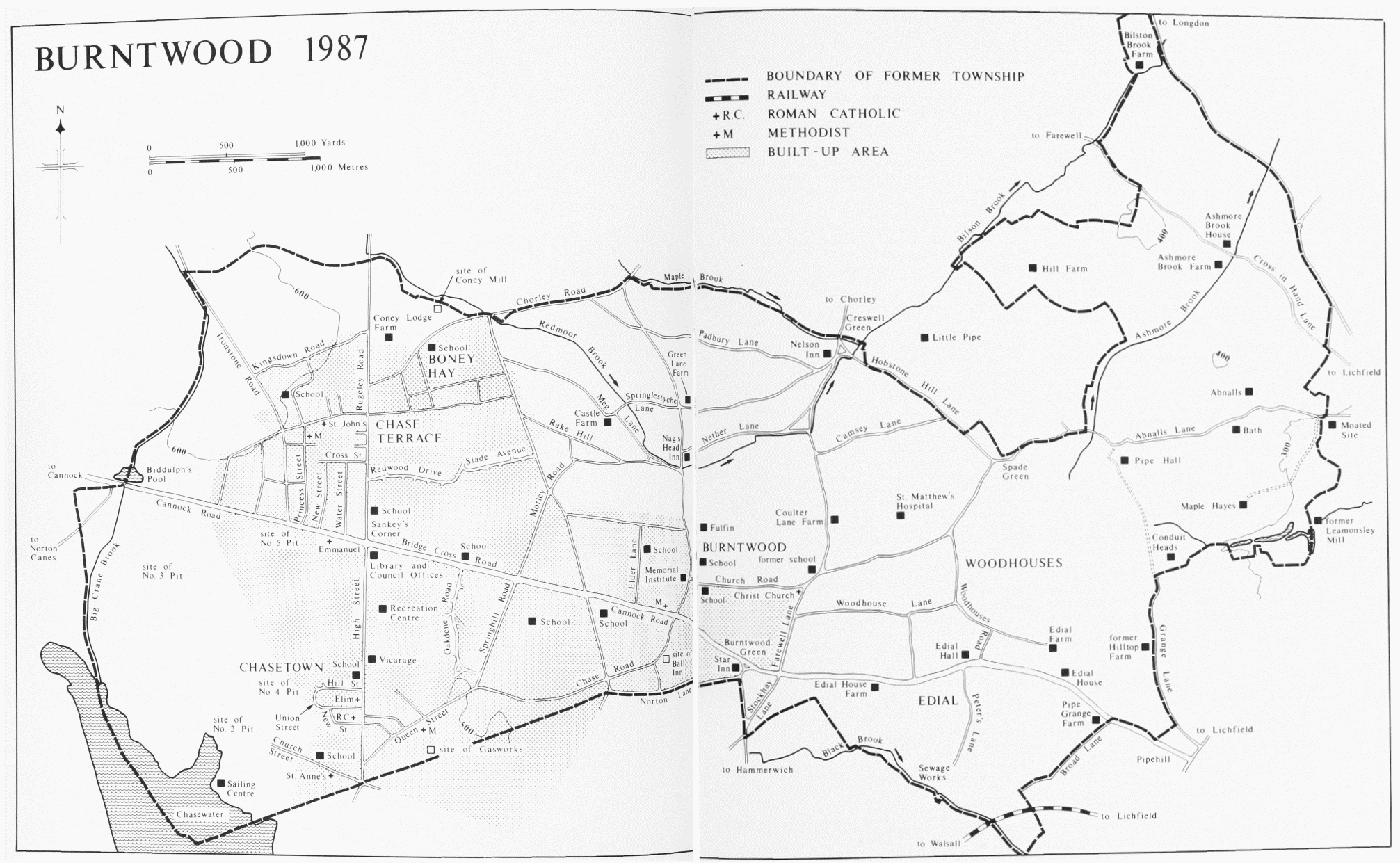
BURNTWOOD 1987
Most of the area overlies the Keuper Sandstone, and on the east Cross in Hand Lane and Abnalls Lane are cut deeply through it. There is an area of Bunter Upper Mottled Sandstone in the south part of Chasetown. The Eastern Boundary Fault of the Cannock Chase Coalfield runs down the western edge of the parish. There is extensive Boulder Clay in the west part of the parish, which remained heathland until its inclosure in 1861. (fn. 16)
Sixty people were assessed for hearth tax in 1666. (fn. 17) In 1801 the population was 582, and it increased steadily to 749 in 1841 and 781 in 1851. (fn. 18) With the development of mining, numbers rose to 1,632 in 1861, 4,525 in 1871 (but including 549 in the lunatic asylum opened in 1864), 6,270 in 1881, and 7,113 in 1891; many of the newcomers were Irish. (fn. 19) The slowing down in the rate of growth was due at least in part to a depression in the coal trade: the master at the school in Chasetown recorded in January 1877 and April 1882 that the depression was causing families to leave the area in search of employment elsewhere. (fn. 20) The population was 8,195 in 1901, 8,636 in 1911, and 9,302 in 1921. After the boundary change of 1929 the reduced parish had a population of 8,883 in 1931. Numbers had risen to 10,750 by 1951 and 12,085 by 1961. The rapid growth of the area as a residential district in the 1960s brought the population to 23,088 in 1971. It had risen to 26,186 by 1981. (fn. 21)
GROWTH OF SETTLEMENT.
The whole township lay within the part of Cannock forest which became Cannock Chase in the 13th century. The eastern side had the earlier settlement and was known as Pipe c. 1140. (fn. 22) The name may have derived from the conduit south of Pipe Hall which supplied water to Lichfield Close or simply from the watercourse (Leomansley or Pipe brook) which rises near the conduit. (fn. 23) A manor house evidently existed at Pipe by the mid 12th century. (fn. 24) There was settlement at Abnalls and Ashmore Brook and probably Edial by the later 13th century and at Woodhouses by the mid 15th century. Burntwood itself was not recorded as a hamlet until the later 16th century and was never part of Pipe manor. The north-east part of the township was known as Childerhay by 1298, (fn. 25) with the area further west around Spade Green known as Childerend Pipe and Childerhay End in the later 16th century. (fn. 26)
The name Burntwood was in use by 1298 when the bishop had 300 a. of common pasture in 'Brendewode'. (fn. 27) The spelling Brundwood became normal in the later 16th century and was itself superseded by the modern spelling in the 17th century. (fn. 28) It has been suggested that the name derives from the burning of a heath in Cannock forest by the vill of Hammerwich; a presentment of the incident was made at the forest proceedings in 1262. (fn. 29) It may, however, derive simply from the clearance of woodland by burning for agricultural purposes. There was settlement at Burntwood by 1570, (fn. 30) and in 1600 a blacksmith of Burntwood was licensed to keep an alehouse there. (fn. 31) The hamlet probably centred on the green at the junction of Norton Lane and Cannock Road. Norton Lane was mentioned in 1449. (fn. 32) Cannock Road was formerly Cannock Street, mentioned in 1698, the name being changed in the early 20th century. (fn. 33) The green was apparently known as Hanley green in the late 17th century, but it was called Burntwood green in 1724. A house which stood there in the early 17th century was occupied as the Star inn by 1790; it has since been rebuilt. (fn. 34) It may have taken its name from Star Lane (later Hammerwich Road) leading south from the green and so named by 1453. (fn. 35) A beerhouse known as the Three Horseshoes stood on the south side of the green by 1770 and was still there in the mid 19th century. (fn. 36) 'Stok' Lane mentioned in 1437 (fn. 37) may have been Stockhay Lane, which runs south-west from the green. By 1775 there was settlement further west on the edge of the heath in Norton Lane and in the northern end of what was later called Chase Road. The former Ball inn, which stood in Chase Road by 1824, may already have been there in 1775. (fn. 38)
There was also scattered early settlement north of the green up to the parish boundary. There were buildings in what is now Church Road by 1775, (fn. 39) and in 1769 a school was opened nearby at the southern end of Coulter Lane, itself mentioned in 1670. (fn. 40) A church was opened in 1820 at the junction of Church Road and Farewell Lane (known as Chorley Road until 1974). (fn. 41) Coulter Lane Farm probably dates from c. 1800. Creswell Green on the boundary at the northern end of Coulter Lane was an inhabited area by 1380 when Henry of Cressewalle was assessed for tax. (fn. 42) There was evidently settlement in the Padbury Lane area to the south-west by 1298 when John of Padbury held land in Pipe. (fn. 43) Padbury Way was mentioned in the early 16th century, and there were buildings in Padbury Lane by 1775. (fn. 44) The Nelson inn at Cresswell Green existed by 1824. (fn. 45)
Fulfen on Rugeley Road to the west was an inhabited area by the 1530s; Fulfen Way was mentioned in 1446. (fn. 46) Cottages had been built at Fulfen by 1577 as encroachments on the waste. (fn. 47) The Nag's Head inn at the junction of Rugeley Road and Nether Lane existed by 1799 and probably by 1775. (fn. 48) A farm occupied the site of Green Lane Farm near the junction of Green Lane and Rugeley Road by 1700, and by 1753 there were two small farmsteads there. (fn. 49) West of Rugeley Road there was settlement by 1775 in the Rake Hill area. (fn. 50) There was waste called Rackhill in 1597, and Rakehill Lane was mentioned in 1670. (fn. 51) The road now called Rake Hill was known as Stephen's Hill in the early 19th century. (fn. 52) Castle Farm in Meg Lane dates from c. 1700. The nearby Springlestyche Lane was mentioned in 1597 as Springlesuch Lane. (fn. 53)
Boney Hay west of Ogley Hay Road became a populous area in the later 19th century. It evidently derives its name from waste called 'le Burnehew' in 1361. (fn. 54) The area was known as Burnehey and Bornehay by the 16th century, and in 1571 there was a house there. (fn. 55) Coney Lodge and Coney mill on the heath to the north-west evidently existed by the 17th century. (fn. 56)
Twenty-nine people in Burntwood were assessed for hearth tax in 1666. (fn. 57) The hamlet and its outlying area had a population of 426 in 1841 and 483 in 1851. (fn. 58) Nailing had by then become important. (fn. 59) With the development of coalmining on the west side of the heath in the 1850s and the inclosure of the heath in 1861 the landscape was transformed. New centres of population developed rapidly. Old roads were realigned or obliterated and new ones were laid out. In particular a new road had been made by 1859 north-west from Burntwood green to the boundary at Biddulph's Pool whence it continued to Cannock. (fn. 60)
The village of Chasetown, at first known simply as Cannock Chase, developed on either side of an existing road running north across the heath; at first the road was called Rugeley Road, but by 1881 it had become High Street. Colliery Road, renamed Church Street by 1881, gave access to the mine opened at its west end in 1852. (fn. 61) There was initially no housing for miners near the pits on either side of the boundary with Hammerwich, and many settled in and around Burntwood hamlet and in Hammerwich. (fn. 62) Three pairs of cottages were built on the north side of Colliery Road c. 1854, and the adjoining Uxbridge Arms existed by 1856. (fn. 63) In 1858 building plots were advertised along Rugeley Road and Lichfield Road (Queen Street by 1881), 'situations where houses are very much in demand'. (fn. 64) An Anglican mission centre was started in the late 1850s, with a church from 1865; there was a school by 1859. The Queen's hotel in Lichfield Road was being used for meetings by Wesleyan Methodists in 1860. (fn. 65) Two shopkeepers, three beer retailers (besides the landlord of the Uxbridge Arms), a builder, a drill owner, a shoemaker, and a market gardener were listed at the village of Cannock Chase in 1860. (fn. 66) A new road (later Edwards Road) linked Rugeley Road and Lichfield Road by 1861. (fn. 67) After the inclosure of that year terraces of houses were built along both sides of those two main roads. (fn. 68) By 1867 the village was known as Chasetown. (fn. 69) The credit for devising the name is variously given to George Poole, vicar of Burntwood, and his wife and to Elijah Wills, master of the boys' department at the school. (fn. 70) New Street and Union Street were so named by 1881, and by 1883 building extended to Hill Street and beyond. (fn. 71) New houses were built further north along High Street in the early 20th century. (fn. 72) In 1902 a clock with three gas lamps was erected at the junction of High Street and Queen Street as a memorial to local people killed in the Boer War. It was knocked down by a lorry in 1967. It was replaced by a new clock in 1969, but that too was damaged in 1979 and no longer stands. (fn. 73)

Chasetown and Chase Terrace 1915: scale 6 in. to 1 mile (1:10,650)
By the early 1860s mining had spread north, with new mines on the south side of Cannock Road. (fn. 74) There was a beer retailer at Biddulph's Pool by 1864. (fn. 75) A new mining village known by 1870 as Chase Terrace developed in the area north of Cannock Road and west of Rugeley Road. Two Oaks inn, in the road called High Street by 1870, existed by 1868 and probably by 1864. (fn. 76) Building land near the inn was advertised in 1868 and 1870 and in Ironstone Road in 1868; Ironstone Road itself was an old road across the heath. Building plots in a new road leading off Ironstone Road were advertised in 1871. (fn. 77) The same year 101 plots were advertised fronting on Cannock Road, Rugeley Road, and other roads then being made. It was stressed that houses were in great demand and rents high; many of the miners employed in the nearby pits had to walk many miles to work. (fn. 78) A Primitive Methodist chapel was opened in Prince's (by 1915 Princess) Street in 1870 and a school in Cannock Road in 1875. (fn. 79) On the east side of Rugeley Road Boney Hay was already a predominantly mining community in 1861, and it continued to develop as such over the next two decades. (fn. 80) In 1884 the Chase Terrace area had a population of nearly 2,000. (fn. 81) Chase Terrace itself continued to expand. Cross Street and New Street had been formed by 1900 and Water Street by 1915; by then the corresponding side of Rugeley Road had been built up. (fn. 82) By 1928 the population of the area was 3,350. (fn. 83)
Several farms were formed after the 1861 inclosure. Bridge Cross farm, south-east of the crossroads on the Cannock and Rugeley roads, dated from 1864; Byrdes Crosse, a place name found in 1578, was probably an early form of Bridge Cross. (fn. 84) Thomas Sankey was evidently the first occupant of the farm, and by 1900 the area round the crossroads was known as Sankey's Corner. (fn. 85) Bridge Cross House Farm further east on the north side of the main road had been built by 1866, with Morlings Farm to the north-east and Spinney Farm at Boney Hay by 1883. (fn. 86)
A large number of houses were built between the two World Wars, notably along the Cannock road, Springhill Road, and the northern stretch of High Street, Chasetown. (fn. 87) Parks were laid out. That at the southern end of High Street, Chasetown, was opened in 1923 as a war memorial. The ornamental gateway was erected by miners' subscriptions in memory of Arthur Sopwith, general manager of the Cannock Chase Colliery Co. 1873–1918. (fn. 88) Burntwood park at the junction of Cannock Road and Elder Road was opened in 1931 and Chase Terrace park between High Street and Cross Street in 1932. (fn. 89)
Soon after the Second World War the Oakdene estate east of Chasetown was begun, and it was still expanding in 1958, when it was the largest council estate in Lichfield rural district. (fn. 90) The last mine in the area was closed in 1959, but between 1961 and 1971 the population nearly doubled as Burntwood became an overspill area for people from Birmingham and the Black Country. The western side of the parish developed as a predominantly residential district with both council and privately built housing. (fn. 91) Building continued in the 1980s; council estates have included one of 26 houses and flats on derelict ground between Queen Street and High Street in Chasetown completed in 1986 and the Rake Hill estate begun that year. (fn. 92) There has been industrial development on the mining sites south-west of Sankey's Corner and also in Chasetown and Burntwood, but most of the working population are commuters whose employment is outside the area. (fn. 93) Sankey's Corner has become the commercial and administrative centre, with the development of an industrial estate, the opening of the Burntwood Town Shopping Centre and the market in 1970, and the completion of the library and the parish council offices in 1987. (fn. 94)
The hamlet of Edial developed along the stretch of the Lichfield road east of Burntwood known by 1409 as Edial Lane. (fn. 95) A house in the area passed to the Kynchall family in 1299; the place from which they took their name evidently lay around the junction of Lichfield Road and Broad Lane where the late 18th-century Pipe Grange Farm stands. (fn. 96) Broad Lane, so called in 1453, may be the Kynchall Lane of 1412. (fn. 97) An inn kept by the Webbs of Edial at least between 1417 and 1466 was probably the inn in the township mentioned in 1496. (fn. 98) A predecessor of Edial House Farm existed by the later 17th century and probably earlier, and the Edial Hall demolished in 1809 probably dated from the late 17th century. (fn. 99) Edial Farm was built as a small house in the later 18th century and was extended twice in the 19th century; it has farm buildings of the late 18th and early 19th century. (fn. 100) Edial House originated in the late 18th century as a small brick cottage. It was enlarged by the addition of a new block towards Lichfield Road in the early 19th century and another to the east late in the century; it was further enlarged to the west in the later 20th century. (fn. 101) Forge Lane was so named by 1616. (fn. 102) Peter's Lane existed by 1725. (fn. 103) A stretch of the railway opened in 1849 from Walsall to Wychnor via Lichfield (fn. 104) runs across the area south of Broad Lane. In 1666 sixteen people in Edial were assessed for hearth tax. (fn. 105) The population was 98 in 1841 and 76 in 1851. (fn. 106)
The rest of the parish lay within the hamlet of Woodhouses and included small settlements at Abnalls and Ashmore Brook. In 1666 at least 17 people in Woodhouses were assessed for hearth tax. (fn. 107) The population was 225 in 1841 and 222 in 1851. (fn. 108)
Woodhouses presumably originated as a clearing in the woodland, and the place name 'Wodehousleye' is found in the area in 1374. (fn. 109) Woodhouse green was mentioned in 1433. (fn. 110) Settlement spread along Woodhouses Road, with two open fields to the east extending to the township boundary along Grange Lane. (fn. 111) There was a farm at Hilltop on the Woodhouses side of Grange Lane by the early 17th century; the name Hilltop was in use in 1693. (fn. 112) Woodhouse Lane, formerly called Pinfold Lane and Green Lane, was probably the road described in 1656 as the common road from Pipe-Woodhouses to Cannock heath. (fn. 113) A county lunatic asylum was opened in 1864 on Hobstone Hill north-west of Woodhouses. (fn. 114) A way at Hobbestone mentioned in 1392 may have been the Hobbestone Lane of 1571 and the Hobstone Hill Lane which runs south-east from Cresswell Green along the parish boundary. (fn. 115) Spade Green on the boundary further south-east was mentioned in 1538 and was an inhabited area by 1690 when Spade Green House was mentioned. (fn. 116) Thirteen poplars were planted at Spade Green to commemorate the battle of Waterloo; the last was cut down in 1930. (fn. 117)
Abnalls on the road from Lichfield to Chorley was an inhabited area in 1275, (fn. 118) but its name, probably Old English in origin and meaning Abba's nook of land, (fn. 119) suggests earlier settlement. The moated site on the Lichfield side of the boundary may have been that of the medieval manor house. (fn. 120) The road, now Abnalls Lane, was known as Pipe Lane at least between 1464 and 1683. (fn. 121) The point where it goes over the boundary was described in 1597 as 'the place where the broken cross in Pipe Lane stood'; a ditch at Broken Cross was mentioned in 1467. (fn. 122) There was a farm at Maple Hayes south of Abnalls by the early 18th century; the present house there dates from c. 1790. (fn. 123)
The grounds of what was formerly the home farm of Maple Hayes on the south side of Abnalls Lane contain the remains of the botanic garden laid out by Erasmus Darwin in the late 1770s. The 7½-a. site on an east-facing slope was described by Anna Seward as 'a little, wild, umbrageous valley, a mile from Lichfield, amongst the only rocks which neighbour the city so nearly. It was irriguous from various springs, and swampy from their plenitude.' It included a spring called Unett's Well and the bath built over the spring by Sir John Floyer in 1701, 'the only mark of human industry which could be found in the tangled and sequestered scene'. There Darwin 'widened the brook into small lakes' and also 'taught it to wind between shrubby margins'. He planted a variety of trees and plants, 'uniting the Linnean science with the charm of landscape'. (fn. 124) Darwin left Lichfield in 1781, and William Jackson, a fellow member of the Lichfield Botanical Society and a proctor of the bishop's consistory court, then looked after the garden until his death in 1798. (fn. 125) In 1799 Darwin conveyed the lease to his son Erasmus, although he successfully opposed his son's plan to build himself a cottage there. (fn. 126) The younger Erasmus's widow Elizabeth conveyed the lease in 1804 to John Atkinson, who the same year had bought Maple Hayes. (fn. 127) The site was advertised for letting in 1823 as the Abnalls 'with the Bath and fruit trees'. (fn. 128) Terraces and low banks there may indicate former garden features. The deeply cut stream along the south side is fed by at least two springs, and several pools formed by damming it survive. The larger spring is enclosed by the bath.
By the late 13th century there was settlement at Ashmore Brook, which lies on the road from Lichfield to Farewell mentioned in 1292. (fn. 129) The route of the London-Chester road formerly followed the lane as far as the Lichfield-Burntwood boundary and there branched off along the boundary. (fn. 130) By the later 17th century a hamlet on the boundary by the fork was known as Cross o' th' Hand. It took its name from 'the cross with the hand' mentioned in the later 15th and early 16th century, evidently a direction post. A post stood there in 1675, but it had gone by 1728 when the highway surveyors of St. Chad's parish were presented for not erecting 'a hand to direct travellers' at Cross o' th' Hand. (fn. 131)
To the north the boundary follows the line of the London-Chester road to a point beyond the bridge over Bilson brook; a bridge existed by 1597. (fn. 132) Bilston Brook farm in the north-eastern tip of the township was held by Thomas Bilson in 1580 and 1592, and his grandfather had held it before him. (fn. 133) The grandfather was probably the Thomas Bilston who was described as of Longdon Way c. 1540. (fn. 134) The farmhouse has a timber-framed cross wing which probably dates from the 17th century. (fn. 135) Hill farm to the south-west existed by the earlier 18th century. (fn. 136)
SOCIAL AND CULTURAL ACTIVITIES.
In the Middle Ages the inhabitants of Burntwood held their wake on the Sunday after Michaelmas. (fn. 137) A mid-October race meeting on the heath was started in 1835; the course, just under a mile round, was in the Ball's Mount and Spring Hill area west of Burntwood hamlet. The last meeting was held in 1854. (fn. 138) In 1896 land known as the old Burntwood racecourse, 12 a. in extent and fronting on the Lichfield-Cannock and Rugeley-Brownhills roads, was sold as 100 building plots. (fn. 139)
What became known as the Chase Wakes originated in the wakes at Chasetown held to celebrate the opening of St. Anne's church in September 1865. They became an annual event held on the third Monday, Tuesday, and Wednesday in September. In the mid 1870s they were transferred to the first Monday, Tuesday, and Wednesday. (fn. 140) A flower show was introduced on the Tuesday and Wednesday in 1868. (fn. 141) In 1877 a group of leading inhabitants started an athletics meeting on the Wednesday in a field in Church Street near the Colliery school, the aim being to keep people occupied 'at a time when, being out of harness, there is a tendency to give way to extravagant and pernicious practices'. From 1878 the meeting was held on the Tuesday also, and the sports became the central event of the wakes. In 1879 the proceedings on both days began with a procession which 'perambulated the country from Brownhills to Burntwood' and consisted of 'a cavalcade of inhabitants representing various characters in picturesque and grotesque costumes'. (fn. 142) A fun fair had been added by 1883. The date had by then been changed to the second Tuesday and Wednesday in August, evidently in order to coincide with the school holidays. (fn. 143) In 1919 the wakes were moved from Church Street to the Cannock Chase Colliery Co.'s sports ground on the east side of High Street, Chasetown. With the decline of coal mining in the area support for the wakes dwindled, and they ceased in 1959. In 1970 they were revived by Burntwood parish council on the same site, and they continue to be held on the first Saturday in August. (fn. 144)
The High Street ground was also used by the colliery company's football team, formed c. 1875. In the 1935–6 season it won the Walsall and District League Championship, the Fazeley Charity Cup, and the Walsall Senior Cup. (fn. 145) In the early 1930s there was a Princess Street Albion Football Club in Chase Terrace. (fn. 146) Chasetown Football Club originated in 1954 as Chase Terrace Old Scholars Youth Club, adopting the new name in 1972. Its pitch was on the High Street ground until 1983 when it opened the Scholars ground and clubhouse at the west end of Church Street. The facilities are also used by a number of other sports and social clubs. (fn. 147) By 1868 Chasetown had a cricket club, probably the colliery cricket club in existence by 1870 with a ground apparently in Church Street. (fn. 148) In 1883 a cricket match was played between Burntwood and Hammerwich, evidently under the auspices of the respective incumbents; the Burntwood club was probably attached to the Burntwood Young Men's Friendly Society. (fn. 149) St. Matthew's cricket club dates from 1897. (fn. 150) There was a lawn tennis club at Chasetown by 1888. (fn. 151) In 1963 the National Coal Board leased the sports ground in High Street, Chasetown, to Burntwood parish council, which opened a swimming bath there in 1969; the present recreation centre includes squash courts and a table tennis room added in 1975 and a sports hall added in 1980. (fn. 152)
By the summer of 1899 Norton Pool was attracting local people and others from further away with a steamer and other boats provided on weekdays by Donaldson & Sons, apparently of the Uxbridge Arms in Church Street. (fn. 153) In 1956 the pool, having been taken over by Brownhills urban district council, was renamed Chasewater and opened to the public. The development of the pool and the adjoining land as a sailing centre and pleasure park was continued from 1966 by Aldridge-Brownhills urban district council and after further local government reorganization in 1974 by Walsall borough council and Staffordshire county council. (fn. 154) The premises of Chase Sailing Club and Staffordshire Schools Sailing Centre are situated on the Chasetown shore. In 1986 reclaimed mining land on the same shore was opened as a park of 50 a. whose facilities include several sports pitches. (fn. 155)
Chasetown had a cinema by 1915, the Palace de Luxe near the junction of High Street and Church Street. It was closed in the early 1920s and reopened in 1933 as the Plaza, which was advertised for sale in 1957. In 1987 the building was used by a car-spraying business. The Chase Cinema at Sankey's Corner was opened in the mid 1930s and was a bingo hall by 1987. (fn. 156)
There was a Chasetown brass band by 1868, probably the colliery company's band which by the late 1870s played at the athletic sports meeting and led the processions. (fn. 157) By 1893 it was performing at the Lichfield Greenhill Bower, and it was regularly engaged by the Bower committee in the earlier 20th century. (fn. 158) Having won second prize in a competition in 1919, it became known as the Cannock Chase Colliery Silver Prize Band. (fn. 159) A Chasetown Temperance Brass Band was formed in 1897, and in the summer of 1899 it gave sacred concerts on Sundays on the dam of Norton Pool on the Hammerwich side of the boundary. (fn. 160) A drum and fife band was formed at Christ Church, Burntwood, in 1886 with 24 members, (fn. 161) and there was a brass band attached to Boney Hay mission room, opened in 1893. (fn. 162) Chase Terrace had a choral society in 1882. (fn. 163)
J. R. McClean (d. 1873) established a free lending library for the colliery company's employees, with the books kept at the Colliery school and available on Tuesday evenings. (fn. 164) By 1881 Chasetown had a reading room which was considered superior to that at Lichfield 'for variety and judicious selection of publications'. (fn. 165) In 1899 a reading room for young people was opened over two shops in Eastgate Street, Chase Terrace, with upwards of 30 members and a subscription of 2d. a week. (fn. 166) When the county council established its circulating library service in 1916, the first centres included three council schools in Burntwood, Chasetown, and Chase Terrace; the Roman Catholic school in Chasetown was added later in the year. (fn. 167) A branch library was built at Sankey's Corner in 1955 and was enlarged to house a children's section in 1965. (fn. 168) Rebuilding began in 1984. Part of the new building was in use in 1986, and the whole was opened in 1987. The name was changed from Chase Terrace Library to Burntwood Library. (fn. 169)
A working men's institute was built in 1888 on a site given by the colliery company at the southern end of High Street, Chasetown. The idea for an institute developed out of a bible class run for the young men of the neighbourhood by Catherine Sopwith, wife of the general manager of the colliery company, Arthur Sopwith. The building originally consisted of a reading room and a billiard room and was lit by electricity generated by the company. The cost of building, some £700, was met by donations and fund-raising events. A hall for entertainments was added within a few years; the billiard room was enlarged shortly before the First World War and again in 1939. Before the nationalization of the coal industry in 1947 the institute bought the freehold of the site from the colliery company. (fn. 170) The institute was closed in 1986 after the trustees had tried unsuccessfully to raise money for refurbishing it. (fn. 171) The building was subsequently demolished.
In 1921 a village institute was opened in wooden premises in Rugeley Road, Burntwood, as a memorial to local people killed in the First World War. There too the cost was met by donations and fund-raising events; W. W. Worthington of Maple Hayes contributed £100. A new building was opened in 1935 and extended in 1948, 1956, and 1957. It was rebuilt in 1971. (fn. 172) The Morley Road Social Centre in Burntwood was opened in the early 1970s. (fn. 173) A women's institute was started at Burntwood in 1922. (fn. 174)
The boy scout movement was introduced into the area in 1914. A troop was formed at Chasetown, meeting in an upstairs room at the Uxbridge Arms. Another troop was formed at Chase Terrace, meeting first in private houses and then at the Cannock Road school. A building in Ironstone Road was bought for it in 1928; extended in 1935, the building remained the headquarters in the 1980s, when there were also groups at Boney Hay and Burntwood. (fn. 175)
There was a friendly society at Burntwood by 1799, from which year the overseers paid 'club money' on behalf of certain poor. (fn. 176) It was probably the Burntwood Friendly Society which owned a meadow in the Boney Hay area in 1815. (fn. 177) A new Burntwood Friendly Society was founded in 1831 and was meeting at the Star in 1876. (fn. 178) The Burntwood Female Friendly Society was formed in 1835 and also met at the Star; it still existed in 1849 but not in 1876. (fn. 179) The Loyal Star of Hope Lodge of Oddfellows was founded in 1872 and met at the Star in 1876. (fn. 180) A Young Men's Friendly Society was formed in connexion with Christ Church, Burntwood, in 1883. (fn. 181) In 1894 the Pink Friendly Society, evidently for women was meeting at the Star. (fn. 182)
Chasetown had six registered friendly societies in 1876: the Engineers' Lodge of Oddfellows, founded in 1861 and meeting at the White Lion; the United Adult and Juvenile Independent Friendly Society, founded in 1862 and meeting at the Staffordshire Knot; the Court McClean of the Ancient Order of Foresters, founded in 1862 and meeting at the Uxbridge Arms; the McClean Cannock Chase Colliery Lodge of Oddfellows, founded in 1867 and meeting at the Colliery school; the Chasetown Primitive Methodist Benevolent Society, attached to Zion's Hill chapel and registered in 1868; and the Pride of the Chase Lodge of United Free Gardeners, founded in 1876 and meeting at the Staffordshire Knot. (fn. 183) A Female Friendly Society in association with the Primitive Methodist chapel at Chase Terrace was formed apparently in 1883, (fn. 184) while a Chasetown Female Benevolent Society was meeting at the no. 3 board school in 1888. (fn. 185) In 1899 there were two other female societies, the Victoria at Chasetown and one associated with the Methodist New Connexion chapel at Chase Terrace. (fn. 186)
The Rechabite movement was introduced into the area in the earlier 1890s by A. H. Atkins, assistant master at the no. 1 board school in Burntwood, and his wife Edith, a draper. Atkins established a tent for men and another for juveniles at Chasetown; his wife established a female tent there and a juvenile tent at Burntwood. About 1920, after her husband's death, Edith founded a mixed tent at Burntwood named after him and was running that and the Burntwood juvenile tent in the late 1930s. She was still living in 1941 when her son F. H. Atkins, also a staunch Rechabite, died. (fn. 187)