A History of the County of Durham: Volume 3. Originally published by Victoria County History, London, 1928.
This free content was digitised by double rekeying. All rights reserved.
'The city of Durham: Rivers, bridges and mills', in A History of the County of Durham: Volume 3, (London, 1928) pp. 62-64. British History Online https://www.british-history.ac.uk/vch/durham/vol3/pp62-64 [accessed 25 April 2024]
RIVER, BRIDGES AND MILLS
The River Wear, one of the most important physical features that influenced the development of Durham, did not always follow its present course. Formerly after flowing from Shincliffe Bridge north-westward to Maiden Castle Wood, instead of taking a turn to the north-east, as it now does, it skirted the northern slope of Maiden Castle and took a U-shaped curve back to its present course. At the end of the curve lay Scaltok Mill (fn. 1) belonging to the convent, to which the inhabitants of the borough and barony of Elvet owed suit. (fn. 2) The alteration in the course of the river possibly made this mill useless, as the leases of it cease after about 1559. (fn. 3) The progress of the river northward of the curve is barred by the Gilesgate ridge; it therefore flows westward for half a mile and then, instead of following the route of the preglacial river, through the sand filled hollow connecting the castle plateau with Gilesgate, it cut its way southward through the rocky ridge on which the higher part of Elvet and Crossgate stand. (fn. 4) Just before the turn in the river here there is a modern iron bridge erected in 1889, which replaced a wooden bridge built in the middle of the 19th century. Further southward was the old ford connecting the borough with Elvet, which was replaced by Elvet Bridge. The approach to the ford on its borough side is by Paradise Lane, but on the opposite side it has recently been blocked by the sewerage works.
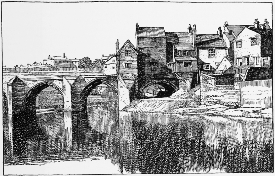
Elvet Bridge, Durham
Elvet Bridge was built by Bishop Pudsey (fn. 5) (1153–95), and with the exception of the two centre arches, which have been rebuilt, the old bridge is intact. It was guarded by a gate and towers and had a chapel at each end; that on the east side still remains. (fn. 6) At about 300 yards south of Elvet Bridge stood Bow Bridge in the 15th century, (fn. 7) which has now completely disappeared. The approach to it on the Bailey side was by Bow Lane, and on the Elvet side by Water Lane. Below the site of Bow Bridge the river, after a semicircular turn, takes a northward direction. Just past the turn here is the Prebends' Bridge built in 1777 from designs by Richard Nicholson. This bridge is a fine stone structure of three semicircular arches with voussoirs springing from piers with triangular starlings surmounted by semi-hexagonal projections, upon which the recesses of the footways are carried. The spandrels are filled by plain recessed panels, and the whole is crowned by a shallow cornice and plain parapet, the latter having panels of balustrading over the centres of the side arches. There was in early times a ferry boat here maintained by the convent, which gave access to their mill, fishponds and orchards at Crossgate. (fn. 8) This ferry was replaced by a footbridge in 1574, which was swept away by the great flood of 1771, and a temporary bridge was erected that remained until the present bridge was built.
Passing the Prebends' Bridge, we reach the first of the weirs, which seems to have been maintained at the common charge of the bishop and convent. (fn. 9) At the western end of the weir were the sites of a corn mill and a fulling mill, both belonging to the convent, (fn. 10) and at the eastern end were two corn mills belonging to the bishop and known as the Jesus Mill and Lead Mill. These latter mills provided for the castle area and were bought by the prior from the bishop in the 15th century. (fn. 11) In 1792 one of these mills on the eastern side was leased for carding of wool and cleaning of cloth. A further lease dated 1813 contains covenants to raise the water in the river 12 in. by planks and not to grind corn at the mill at the western end of the weir between midnight and 6 a.m. from 1 May to 11 November. These mills appear to have fallen into disuse shortly after this date.
A quarter of a mile below the weir the river is crossed by Framwellgate Bridge, or the Old Bridge, as it was called in mediaeval times to distinguish it from the later Elvet Bridge. This bridge was originally built by Flambard in 1120, but it was swept away by a flood in 1400. For a time a crossing was maintained by a ferry boat, but the present bridge was built in the 15th century by Bishop Langley (1406–37) and was widened in the early part of the 19th century. It consists of two arches, each of 90 ft. span, and was formerly fortified by towers and gates at each end. In 1316 a fight took place between Richard Fitz Marmaduke, the bishop's steward, and Robert Neville, 'the peacock of the north,' 'for dispute who might rule the most.' Fitz Marmaduke was defeated and killed. (fn. 12) Below this bridge is another weir, at the east end of which was the Bishop's Mill, where the inhabitants of the borough owed suit. This mill is mentioned in the Boldon Book, (fn. 13) and was usually leased separately from the borough, but sometimes with it. (fn. 14) In 1543 it had fallen out of repair by the violence of the stream, when Bishop Tunstall granted a lease of the River Wear from the Milburn to Lowicke Haugh to Robert Rawe, bailiff of Durham, and Ralph Surtees, merchant, for 70 years in order to build another mill. A mill was accordingly built, but certain inhabitants withdrew their suit and erected a horse mill on the site of a burgage held from the dean and chapter. In an action that followed the bishop's lessee obtained judgment and damages. (fn. 15)
At the western end of the weir the Milburn, which now runs in a culvert under the North Road, flows into the Wear. Formerly its waters were used to drive the Clock Mill at the foot of Milburn Gate. At it the inhabitants of the old borough of Crossgate had to grind their corn. This mill was granted by Bishop Flambard to Kepier Hospital, (fn. 16) and afterwards passed to the almoner of the convent, (fn. 17) and only ceased to be used as a mill within living memory. Threequarters of a mile below this second weir there used to be another weir for supplying power to the mill attached to Kepier Hospital.
The bishop appears to have had the fishery of the river, and in 1312 granted to the prior and convent a free fishery between Elvet Bridge and Framwellgate Bridge, (fn. 18) and from time to time leased the waste ground between the castle walls and the river. (fn. 19)