A History of the County of Essex: Volume 5. Originally published by Victoria County History, London, 1966.
This free content was digitised by double rekeying. All rights reserved.
'The borough of Barking', in A History of the County of Essex: Volume 5, ed. W R Powell (London, 1966), British History Online https://www.british-history.ac.uk/vch/essex/vol5/pp235-248 [accessed 30 April 2025].
'The borough of Barking', in A History of the County of Essex: Volume 5. Edited by W R Powell (London, 1966), British History Online, accessed April 30, 2025, https://www.british-history.ac.uk/vch/essex/vol5/pp235-248.
"The borough of Barking". A History of the County of Essex: Volume 5. Ed. W R Powell (London, 1966), British History Online. Web. 30 April 2025. https://www.british-history.ac.uk/vch/essex/vol5/pp235-248.
In this section
BARKING
THE GROWTH OF BARKING.
The medieval plan of Barking town can be seen from the map of 1653, (fn. 1) used in conjunction with earlier records of street names. North Street, Hithe (now Heath) Street, East Street, Baker (now Axe) Street, Loxford (now Tanner) Street, and Vineyard Lane (now Ripple Road — King Edward's Road), are all mentioned in 1456. (fn. 2) Fish Row (1456) was possibly identical with the later Fisher Street (now Abbey Road South). In 1653 the town contained about 170 houses. During the next 150 years it grew little: the only important change was the construction in the early 19th century of New (now London) Road, mentioned above. (fn. 3)
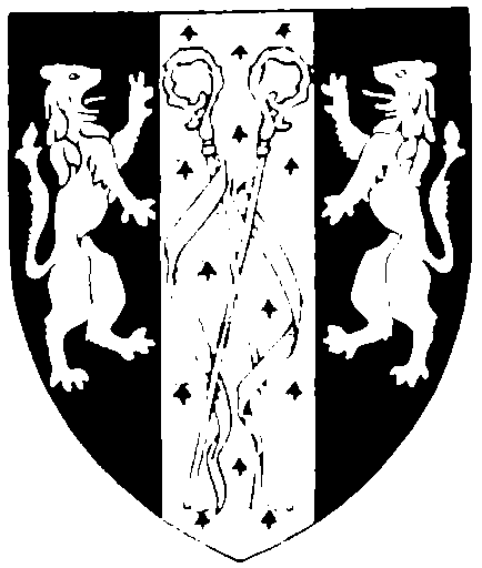
Barking Municipal Borough. Sable, on a pale ermine between two lions rampant combatant, two abbess's crosiers in saltire, or
The old nucleus of the town, clearly shown on the map of 1653, was the market place, which lay south-east of the abbey site and immediately east of St. Margaret's churchyard. At its centre stood the market hall or court house, built in 1567–8, (fn. 4) surrounded by shops. Barking had long had its shops. The first known reference to one is in 1254 (fn. 5) and from the 14th century onwards they were sufficiently numerous to indicate that Barking was no longer a mere village. (fn. 6) In the same area, by 'Horspole' — probably the horse pool outside the abbey gate — a tavern stood in 1456. (fn. 7) Here too, the principal builtup streets converged. Back Lane, and its continuation Heath Street, led south and west from the market place to Barking Creek and the town wharf. (fn. 8) The wide pool which lay at the head of the creek was spanned at its north end by a causeway with bridges and sluices, now High Bridge Road. To the north of it stood Barking Mill. (fn. 9) This general layout survived until after the First World War. (fn. 10) By the 20th century, however, the gradual cessation of the Saturday market had caused the market-place area to decline in importance and at the same time the vital function of the wharf in the town's economy had almost disappeared.
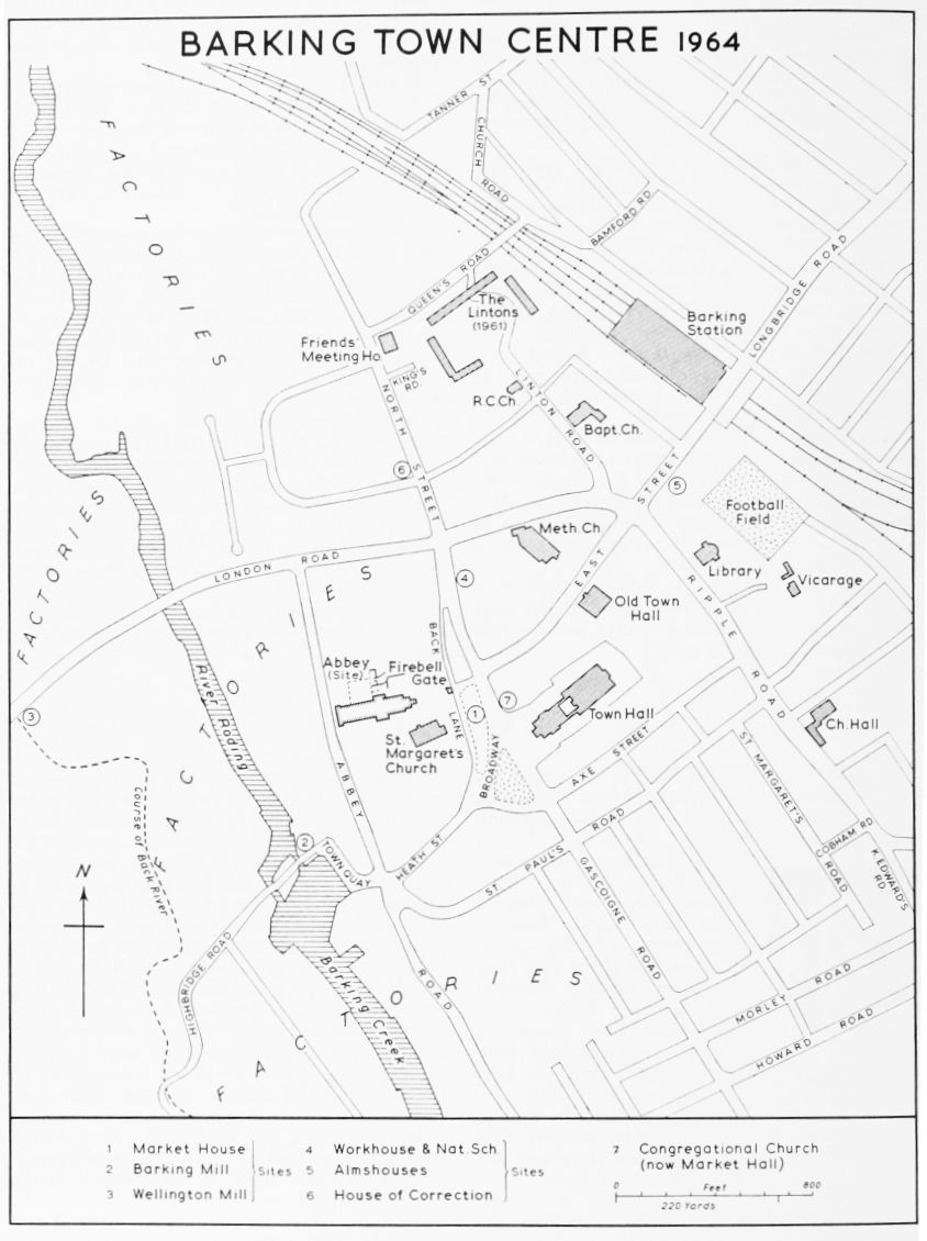
BARKING TOWN CENTRE 1964
In 1801 the population of Barking was still very small: only 1,585 in the town ward and 280 in Ripple ward. It rose steadily to 4,930 (town) and 435 (Ripple) in 1851. (fn. 11) The increase in the town ward was remarkable in one important respect: it took place within an area little bigger than that of the 17th-century town. (fn. 12) It is clear that during the earlier 19th century the new inhabitants, attracted by the growth of the fishing industry, crowded into tenements built or converted for the purpose in and behind the old streets. This conclusion is borne out by the 1851 census schedules; (fn. 13) and indeed the creation of slums at that time was one of the main causes of the great clearance which has taken place in the old town since the First World War.
In the 1850's the population rose little, but its growth was resumed in the 1860's, and continued in spite of the collapse of the local fishing industry in 1865. (fn. 14) By that time other industries were beginning to develop, near the town quay and also at Creekmouth, and the town's first railway line had been opened, linking it with London. In the later 19th century the increasing population was matched by an expansion of the urban area. By 1862 several new streets had been laid out in the north of the town, including King's, Queen's, and Station (now Linton) Roads, to the west of the railway, and Church Road and Bamford Place (now Road) to the east of it. (fn. 15)
At the north end of North Street and in some of the roads to the west of the railway, there were a few detached and semi-detached houses; elsewhere building took the form of terraces of small houses or cottages. The development to the east of the railway, originally known as Barking New Town, was continued during the late 19th and early 20th centuries. The streets were built up with continuous terraces of uniform two-storied houses, each with its bay window, small front enclosure, and back yard or garden. These dwellings, slightly larger than cottages, were probably built for occupation by 'white-collar' workers, going daily by train to the City. (fn. 16)
Meanwhile the town was also expanding southwards: most of the streets between Fisher Street (now part of Abbey Road) and King Edward's Road were laid out between 1880 and 1900. Terraces in St. Paul's Road, Cobham Road, and St. Margaret's Road are dated 1881–8, and in Gascoigne Road 1891–4. This appears to have been a less 'genteel' area than Barking New Town, perhaps intended for occupation by workers in local industry. Here the first council houses, also in continuous terraces, were built in 1902. (fn. 17) By 1920 some building had taken place east of King Edward's Road. (fn. 18)
The population of Barking sub-district (i.e. Barking town and Ripple wards) rose from 5,591 in 1861 to 35,523 in 1921. (fn. 19) The growth of the town made an internal by-pass necessary, and in 1909–10 the council built Abbey Road from Heath Street to London Road across the former abbey lands. The land to the west of the new road, beside the Roding, was sold for industrial development. (fn. 20) Outside the old town ward there was little building before the First World War. In the later 19th century a few houses were built near the factories at Creekmouth, (fn. 21) but the rest of the old Ripple ward remained rural.
In the 1920's the town spread east, along Ripple Road and Longbridge Road, and in the area between these roads, and by 1931 the population was 51,270. (fn. 22) Meanwhile the L.C.C. was building the Becontree housing estate. Work on the Barking part of the estate, comprising about 9,000 houses, started in 1930, and was completed by 1935. (fn. 23) The new area thus built up stretched from the Dagenham boundary west to Lodge Avenue. By 1938, when the expansion of the borough was virtually complete, the estimated population was 76,790. (fn. 24) Its recent decline, to 72,293 in 1961, (fn. 25) has been due partly to the change in the age-distribution pattern, especially on the Becontree estate, and partly to re-development. The period between the two World Wars saw great changes in the older part of the town. With the decay of the market-place area, the town centre was tending to move north-eastwards, towards the station and the now busy junction of East Street and Ripple Road. Until c. 1910 an 18th-century house called Paddocks had stood at this junction, while Ripple Road itself was almost clear of houses. (fn. 26) In the early 20th century and between the wars this area became the site of public buildings, banks, and the larger retail shops. Meanwhile clearance was taking place in the old town to the west. The market hall was taken down in 1926 and the block of buildings to the north of it, which included the old vicarage, in 1935. (fn. 27) A row of houses between the market place and the churchyard was also demolished. The extension of London Road in 1937 necessitated clearance between North Street and Linton Road. Demolition also took place east of Broadway, where a large site was designated for the new town hall, and at the junction of Broadway, Axe Street, and Heath Street. Heath Street itself, the narrow built-up thoroughfare leading to the wharf, was completely cleared. Old Barking mill was demolished in 1922 and when, some years later, the buildings along the town quay were taken down, the environs of Barking Creek lost much of their maritime character. (fn. 28)
The town council has played an active part in the growth of Barking during the last sixty years. Even before the First World War it had started clearance in the old town and built new houses in King Edward's, Howard, and Morley Roads. (fn. 29) Between the wars slum clearance was accelerated and the council built housing estates at Greatfields, Eastbury, Upney, and elsewhere. (fn. 30) Since the Second World War the new town hall, opened in 1958, has been built. More clearance to the west of it has prepared the way for a large open space to be laid out between Broadway and St. Margaret's churchyard; eventually this will cover much of the site of the old town. A major redevelopment at the north end of Linton Road consists mainly of 'slab' blocks of flats in pre-cast concrete, including one structure of 16 stories. (fn. 31) Nearby are the new almshouses in a 2-storied block. (fn. 32) The largest of all the council's housing schemes has been the Thames View estate, south of the Barking by-pass, comprising over 2,000 dwellings, built in 1954–60. (fn. 33) This is notable not only for its size but for its location; the site was formerly marshland, thought unsuitable for housing but reclaimed by means of piles and rafts. The scheme includes terraced housing, blocks of flats, maisonettes, places of worship, schools, and a shopping centre.
Very few buildings in the borough are more than a century old. The medieval parish church, the Fire Bell Gate and other remains of the abbey, the 18th-century vicarage, and Eastbury House, a fine mansion of red brick built by a 16th-century merchant, have been described elsewhere. (fn. 34) The 18th-century manor house of Bifrons, south of Axe Street, was demolished in 1815–16. (fn. 35) Notable buildings destroyed since 1900, besides those already mentioned, include Fulks manor house, the former workhouse, and the original Friends' meeting house, all in North Street, the manor houses of Jenkins and Porters, and the windmill near the London Road. (fn. 36) A few early-19th-century buildings survive in East Street but in general all the houses, shops and public buildings in the centre of the town date from the last hundred years. The most notable recent buildings, apart from the town hall, are the new station booking hall, opened in 1961, and St. Margaret's church hall on the site of St. Paul's church in Ripple Road, built in 1955. (fn. 37)
MARSHES AND SEA DEFENCES. (fn. 38)
The marshes of Barking lie between Ripple Road and the Thames, and between Back River and the Roding, a total of some 1,300 a. In most parts of this area the land is now less than 10 ft. above mean sea-level. During the Middle Ages it was probably several feet higher, (fn. 39) but even then flooding was frequent. (fn. 40) Serious floods could cause the temporary loss of large tracts of valuable pasture land, and from the 13th century, if not earlier, attempts were being made in this parish to keep out the sea by means of walls and drainage ditches. (fn. 41) The primary responsibility for this rested on the tenants of the marshland, and especially on the Abbess of Barking, as lady of the manor and owner of the demesne farms of Eastbury and Westbury. In spite of her great wealth she sometimes found the burden too heavy, and had to seek tax reliefs and other concessions from the government. In 1291 she was licensed to sell timber from Hainault Forest in aid of her land in the marshes. (fn. 42) After the severe floods of 1377 she was excused muster duty (fn. 43) and three years later, in consideration of her great expenses in repairing the Thames dykes, she was allowed to commute, for a small annual rent, her duty to repair 1½ mile of the inclosure of Havering Park. (fn. 44) In 1382, when it was stated that her income had been reduced by 400 marks a year as the result of floods, she was licensed to appropriate Hockley church. (fn. 45) Similar concessions were made in 1392 and on several occasions in the 15th century. (fn. 46)
Through her manor court the abbess was able to put pressure on her tenants to share in the maintenance of the sea defences. In 1440–1 land drainage was being supervised through a special session of the manor court called the 'watergang', which imposed fines for failure to scour ditches. (fn. 47) The watergang apparently did not concern itself with the maintenance of sea walls, but there is no doubt that marshland tenants were expected to share the burden of this with the abbey. (fn. 48) How they did so varied according to circumstances. The walls themselves were private property appurtenant to marshland tenements, (fn. 49) the ownership of which carried with it the obligation to maintain the walls. (fn. 50) As long as this was done there was no need for outside action. Serious flooding, however, created an impossible situation for small tenants by simultaneously destroying their assets and increasing their responsibilities. In that situation a man might abandon his holding in despair. (fn. 51)
By the mid-13th century the Crown was beginning to supplement contractual obligations by efforts of its own. (fn. 52) An early instance of such intervention occurred in 1255, when the sheriff was ordered to distrain upon those abbey tenants in Barking Marsh who were failing to pay, as they were bound to do, their contribution towards the repair of the marsh walls. (fn. 53) In the 14th and 15th centuries such obligations were enforced by means of commissions of walls and ditches (de walliis et fossatis). (fn. 54) The commissioners appointed in 1380 and 1384 (fn. 55) were authorized to employ men to repair the walls on the abbey's behalf. In the second case the commissioners enforced the labour but the abbey paid the workmen's wages. After 1427 such commissions began to acquire a statutory basis and eventually evolved into commissions of sewers set up under the Statute of Sewers of 1532. (fn. 56)
The 'levels', or areas within which commissioners of sewers carried out their duties, began to emerge in the later 16th century. In 1563 Barking was under the jurisdiction of a court of sewers, whose area extended from West Ham to Mucking. (fn. 57) The Barking levels then comprised 1,276 a. They included, from east to west: Ripple Marsh (853¼ a.), Poole's Marsh (42 a.), Eastbury Marsh (192½ a.), Westbury Marsh (82¼ a.), Little West Marsh (106 a.). The survey of that year shows that before the Dissolution Barking Abbey had owned 706 a. of land in those marshes. By 1563 the Crown had sold 336 a. of this, but still retained 370 a., mainly in Ripple Marsh, which it had put out on lease. The survey lists 48 owners, including lessees of the Crown, in the Barking levels. Each owner was responsible for the repair of specified lengths of sea wall. (fn. 58) The accounts for Ripple Marsh, 1561–74, show that the commissioners of sewers were raising money by means of taxes, and were also receiving loans from the government. (fn. 59) The Barking marshes later came under the control of the commissioners for the Havering levels, whose jurisdiction, in and after the 18th century, extended from Bromley (Mdx.) to Hornchurch. (fn. 60) By 1740 the total area under the administration of the commissioners of sewers in the Barking levels had increased to 1,480 a. Ripple level, a small part of which lay in Dagenham parish, comprised 1,034½ a., Eastbury and Westbury levels together 352½ a., and Little West Marsh and North Grange and South Grange levels, which together were the equivalent of the Little West Marsh of 1563, contained a total of 93 a. (fn. 61)
Under the Land Drainage Act (1930) the Barking levels came under the control of the Essex Rivers Catchment Board, which by an Act of 1948 was merged in the Essex River Board. The Act of 1930 empowered the catchment boards to levy rates from upland areas not themselves subject to flooding as well as from the marshland tenants. (fn. 62) During the great flood of 1953 Barking escaped with comparatively little damage, though 50 people were made homeless. (fn. 63)
TRADE AND INDUSTRY.
Barking owed much of its early importance to its position beside the 'pool' where the River Roding joins an inlet of the Thames. There are several early references to trade: in 1203 two ships taking bacon to Normandy evidently embarked part of the cargo at Barking; (fn. 64) later, in the 14th century, leather and wool are mentioned. (fn. 65) Serious flooding in the late 14th and early 15th centuries temporarily crippled the econnomy of Barking Abbey (fn. 66) and probably affected the port adversely. A decline in the normal trade of the area is suggested by the cessation before 1398 of a fair at North Woolwich. (fn. 67) In the 17th century, and probably at other periods, much timber was shipped at Barking for naval use elsewhere. (fn. 68) There were no further important developments until 1737— about the same time that the town wharf was repaired (fn. 69) — when the Roding Navigation Act provided for the river to be made navigable from Barking Mill to Ilford Bridge. The sponsors of the act believed that it would be 'very convenient for the carriage of corn, coals and other foods and merchandises to and from Great Ilford . . . and to and from London and other parts, as likewise for the carriage of chalk and other manure . . .'. (fn. 70) These hopes were realized: in the 19th century there was a good deal of trade through the wharf at Ilford. (fn. 71) The ownership of the navigation, after passing through several hands, was bought in 1832 by Sir Charles Hulse, lord of the manor of Barking. (fn. 72)
From the 14th century until the mid-19th the most important industry of Barking was fishing. There was a fishery there in 1086 but this was probably only in the Roding. (fn. 73) The earliest mention of salt-water fishing by Barking men was in 1320, when several of them were prosecuted by the authorities of the City of London, conservators of the Thames, for the illegal use of kiddle nets, with too fine a mesh. (fn. 74) Barking fishermen were in similar trouble in 1349 and again in 1406; on the latter occasion they aggravated the offence by rioting against the official who had seized their nets. (fn. 75) In 1456 there was a Fish Shambles and also a Fish Row in Barking, and although few of the abbey's tenants were then described as fishermen others no doubt made fishing a part-time occupation. (fn. 76)
From the 16th century the fishing industry began to grow. It was probably stimulated by the connexion with the Royal Navy and by the enterprises of men like David Ingram of Barking, who sailed with John Hawkins to West Africa and the Caribbean in 1567–9. (fn. 77) In 1574 it was said of Barking that 'all that inhabit there are fishermen'; (fn. 78) and in 1601 the town was stated to be dependent on the fishing industry. (fn. 79) These statements may have been exaggerated, for Barking does not appear to have been among the principal Essex ports during the early 17th century. (fn. 80) In the 1630's a number of Barking fishermen were in trouble for using trawl nets forbidden by a recent government order. (fn. 81) From about that time Barking smacks seem to have ventured further afield, perhaps as the result of restrictions in the Thames. In 1642–73 George Asser and others from Barking were taking oysters in the Crouch and Roach rivers, in defiance of the Earl of Sussex and his successors who claimed a monopoly there. (fn. 82) In 1656 11 ketchmen of Barking joined with others to seek exemption from impressment on the ground that they were supplying London with mackerel and herrings. (fn. 83) This suggests fishing in the North Sea, and some Barking fishermen were going on even longer voyages in the 17th century. Two men, who went to Greenland in 1636 to avoid the press gang, may not have been in Barking ships, but two Barking fishing boats captured by the Irish in 1649 must have been far from home. (fn. 84)
Defoe's description of Barking, which he visited in 1722, gives the impression of a busy little port fishing for the London market. (fn. 85) A document drawn up about that time lists 14 of the Barking smacks, each of which had a master and 4 men. (fn. 86) The industry continued to flourish in spite of increasing competition from Harwich, which in 1712 started using well-decked smacks designed to bring the fish into port alive. (fn. 87) During his visit Defoe spoke to a 'very substantial and experienced' fisherman who convinced him 'that all the pretences to bringing fish alive to the London market from the North Sea and other remote places on the coast of Great Britain by the new-built sloops called fish-pools have not been able to do anything but what their fishing smacks are able on the same occasion to perform'. (fn. 88) This conservative view was mistaken, for well-decked boats later became widely used by fishermen from the Thames ports, including Barking. (fn. 89)
A document of 1805 lists 23 smack owners of Barking. (fn. 90) In 1814 there were said to be 70 smacks of 40 to 53 tons burden. (fn. 91) In 1833 there were 120 and the number went on rising until about 1850 when it reached its maximum of some 220. (fn. 92) The number of smack owners also increased during that period. In 1848 75 'smack owners and masters' were listed. (fn. 93) In 1851 1,370 men and boys were directly employed on the boats. (fn. 94)
Much of this development, by which Barking became one of the greatest fishing ports in England, was due to the enterprise of the Hewett family. (fn. 95) Scrymgeour Hewett came to Barking from Scotland about 1760. He married the daughter of a smack owner named Whennell, and financed by his father, Alexander Hewett, entered the fishing business himself. Samuel Hewett, second son of Scrymgeour, took over the business about 1815. He was the first to organize the fleeting system by which a large number of smacks worked together, transferring their catch daily to fast cutters which took it to market. Three other smack owners, Morgan, Reid, and Forge, also started fleets, but Hewett consolidated his supremacy until his Short Blue Fleet and Home Fleet came to include most of the vessels sailing from Barking. About 60 smacks were wholly owned by him, he had a part interest in some and he welcomed to his fleets boats belonging to others, including trawlers from Brixham (Devon), which at one time joined the Short Blue Fleet for summer fishing. He also introduced the use of natural ice for preserving fish. Most of this came from the marshes and fields around Barking; sluice gates were opened at the onset of winter to flood the marshes and watchers were employed to see that the ice was not disturbed before it was ready for cutting. When it had been cut it was stored in ice-houses, of which there were at least two, built shortly before 1848. (fn. 96) For a time ice was also kept in an old hulk at Rainham and in an ice-house at Dagenham. (fn. 97) The cutters each carried about 18 tons of ice for packaging. Hewett installed at Barking the first artificial ice-making plant in England. This proved too expensive and was discontinued but Hewett later bought artificial ice from a firm at Shadwell (Lond.). He also introduced trunks and boxes for packing fish instead of the wicker 'peds' formerly used.
The Barking smacks of this period were about 75 feet long and of some 50 tons burden. Each carried a crew of 8 or 10, half of them apprentices. They fished the Dogger Bank and coasts of Holland, Germany, Denmark, and Iceland. (fn. 98) The cutters of the Short Blue Fleet could sail faster to windward than any other vessels afloat, and in spring some went to Spain for cargoes of early fruit. (fn. 99) Models of several Short Blue vessels, including one of a well-smack, are in the possession of the Hewett family.
The Barking fishing industry began to decline shortly before 1860. (fn. 100) The 1863 directory lists only 27 smack owners. (fn. 101) The main cause of the decline was the extension of the railways to east coast ports nearer the fishing grounds, which made it possible to get the fish to market without the delays caused by weather conditions in the Thames. Even before the coming of the railways the Barking smacks had sometimes landed fish at Yarmouth and sent it to Billingsgate in horse-drawn vans which did the journey in 12 hours. There were other causes. The Barking fishermen used small and inefficient trawls, and they refused to share in the catch as part of their wages, which made their smacks expensive to operate. (fn. 102) The decline was probably accelerated by a disaster of December 1863: the Barking fleet was badly damaged when fishing off the Dutch coast by a gale which caused the deaths of some 60 men and damage estimated at £6–7,000. (fn. 103) In 1865 Robert, son and successor of Samuel Hewett, transferred most of his trawlers to Yarmouth and Gorleston (Norf.) and this was the end of large-scale fishing out of Barking, although steam carriers continued to operate from there until 1899. Only three Barking smack owners were listed in 1870. (fn. 104)
Barking seamen were often involved with the navy. During the wars of the 17th and 18th centuries Barking fishing boats were used by the navy as fleet auxiliaries. (fn. 105) The fishermen themselves were frequently pressed into naval service, (fn. 106) though some managed to gain exemption: during the reign of Elizabeth I eight of them did so by contracting to supply the Comptroller of the Navy with fish during Lent; this privilege, later commuted for a money rent, was still being enjoyed by their heirs in 1637. (fn. 107) The petition of ketchmen in 1636 for protection from impressment has been mentioned above. (fn. 108) In 1739, and again in 1803, there was violent and largescale resistance to the press gang. (fn. 109)
The Barking seamen were not averse to carrying on their own naval operations, however. During the revolutionary and Napoleonic wars with France a number of Barking vessels sailed as privateers, including the Essex and the Fifeshire, both of which were captained by Scrymgeour Hewett. (fn. 110) At other times the fishermen of Barking acted without official sanction: in the 15th century some of them were charged with piracy; (fn. 111) in 1597 Henry Parish and others were suspected of taking supplies to the Spanish forces at Calais; (fn. 112) in 1667, during the second Dutch war, it was thought that Barking fishermen were acting as spies for the enemy, who allowed them to fish unmolested. (fn. 113) Occasionally, also, there was trouble with revenue officers, in which the men of Barking were not always at fault. (fn. 114)
The port of Barking was sometimes used during the reign of Henry VIII for the repair and fitting out of royal ships, no doubt because it was near the new dockyard at Woolwich. (fn. 115) Some of the timber landed in the 17th century must have been put to this use in Barking. The local skill which this indicates suggests that fishing boats were being built as well as repaired at Barking from the Middle Ages onwards, but there is no direct evidence of this until 1655, when the Nonsuch and the Endeavour are mentioned as newly built there. (fn. 116) In 1666 there is a reference to masts lying in Mistress Naylor's yard at Barking. (fn. 117) A rope-maker occurs in 1683. (fn. 118) In the early 19th century and especially during the fishing boom of 1830–50, shipbuilding and its ancillary industries flourished. (fn. 119) The 1848 directory lists 5 shipwrights, 6 sail-makers, 4 rope- and line-makers, 5 mast-, pump- and block-makers, 3 ship-smiths, and 2 ship-chandlers. (fn. 120) In 1863, when fishing was decreasing, a later edition of the same directory lists only 4 shipwrights, 2 sail-makers, 2 rope-makers, and 4 mast-, pump- and block-makers; there were still 2 ship-chandlers. (fn. 121) Shipbuilding declined more slowly than fishing. Hewett & Sons continued to build and repair fishing boats at Barking until about 1899. (fn. 122)
In the 17th century and later the tavern signs reflected the maritime occupations of the town. In 1640 the 'Dolphin' was said to have been recently converted into a dwelling-house. (fn. 123) Its name recurs in 1754 and 1770. (fn. 124) The 'Ship', and the 'Ship and Shovel', the names of which still survive, the 'Anchor', the 'Bell', the 'Royal Sovereign', and the 'Royal William', also occur in 1754. (fn. 125)
Tanning was carried on at Barking during the Middle Ages. Odo the tanner occurs in 1232–3, (fn. 126) and others of his trade are mentioned in later documents; (fn. 127) they gave their name to Tanner Street. The industry had close connexions with London. In 1367 the king ordered his customs officer in the Port of London to allow Nicholas Snypeston to take a boat-load of hides to Barking to tan. (fn. 128) A Barking tanner, Henry Noble, was in debt to a London cordwainer in 1371. (fn. 129) Tanning was still being carried on in 1520, when John Burr supplied the king with 428 oxhides. (fn. 130) At that period, also, two London skinners held property in Barking. (fn. 131)
In the 14th century wool was being produced on the Barking Abbey estates. (fn. 132) In 1389–90 Nicholas Marchant of Barking was trading in wool, apparently with Holland via Sandwich. (fn. 133) A lease of 1555 mentions 'Teintourcroft' and 'Teynterfelde', probably places in which there were or had been tenters for stretching cloth. (fn. 134) A dyer occurs in 1456. (fn. 135)
The lease of 1555 also refers to land called 'Brykfeld'; this may have been the brickfield which in 1653 was in North Street. (fn. 136) Brewing is suggested by the name Brewer's Croft (1626) and by references, in 1734–93, to the business premises of a maltster. (fn. 137) A basket-maker occurs in 1683. (fn. 138) In the 18th century this industry, much of which was probably concerned with the furnishing of fishpeds, was carried on by several members of the Andrews family. (fn. 139) There were two basket-makers in Barking in 1863. (fn. 140)
The decline of the fishing industry might have had serious consequences for Barking had not other industries been established. One of the first of these, and for a time the most important, was jute-spinning, which was carried on from 1866 to 1891 in a factory in Fisher Street, now Abbey Road. (fn. 141) At the same period several chemical factories were opened. The factory of the Lawes Chemical Co. at Creekmouth, which makes artificial fertilizer and sulphuric acid, was established in 1857 by (Sir) John Bennet Lawes, who sold his interest in it in 1872. (fn. 142) Between 1862 and 1882 Edward Steane had a soap factory in Fisher Street. (fn. 143) Edward Crow was making chemicals at Barking Creek in 1862–70. (fn. 144) By 1878 Daniel de Pass had opened the Barking Guano Works (now de Pass Fertilizers) at Creekmouth. (fn. 145) William Davey's tar distillery, Barking Creek, existed in 1878–1906. (fn. 146) By 1906 there were at least 20 manufacturers in the town, about half of whom were making chemicals. (fn. 147) Since then, and especially since the end of the First World War, the industries of Barking have greatly increased in number and variety. (fn. 148) In 1959 the Barking Manufacturers Association had a total membership of 105: some of the constituent firms were not directly engaged in manufacture, but there were a number of other manufacturers outside the association. (fn. 149) At least 30 firms were engaged in metal production or engineering, 20 in the making of chemicals, and 7 in branches of timber manufacture and joinery. Other local products include cement, asbestos, celluloid, icecream, pickles and sauce, life-saving apparatus, and rubber. (fn. 150) The main industrial areas are in the south of the borough, near the Thames, and on both banks of the Roding near the old town.
LOCAL GOVERNMENT SINCE 1888. (fn. 151)
After the formation of Barking Local Board the parish vestry played little part in local government. It continued to appoint the burial board until 1897, when the functions of the board were taken over by the urban district council. (fn. 152) The local board, formed in 1882, acted vigorously to improve the town. (fn. 153) The board took over the town wharf in 1893. (fn. 154) Barking Urban District Council, which succeeded the local board, in 1897 obtained powers for an electricity and tramway undertaking, (fn. 155) and started a slum-clearance scheme. (fn. 156) These and other public works carried out by the council are more fully described elsewhere. (fn. 157) In 1903 the council took over the functions of the Barking School Board. (fn. 158)
The building of the London County Council's housing estate at Becontree, after the First World War, brought serious administrative problems to Barking and the other local authorities involved. Of the 3,000 a. comprising the estate 900 a. were in Barking. In 1920 it was suggested that Dagenham, then a parish of Romford Rural District, should be divided between the urban districts of Ilford and Barking, but the proposal was rejected by Essex County Council. (fn. 159) In 1929, when boundaries in this area were again under review, the County Borough of East Ham, and Dagenham Urban District, submitted proposals for annexing part of Barking, and it was also suggested that Ilford, Barking, and Dagenham should be amalgamated. In order to strengthen its position Barking Council applied for a borough charter, which was granted in 1931. (fn. 160) In 1933 the borough council acquired additional statutory powers. (fn. 161) The borough is now (1963) divided into 8 wards.
Soon after incorporation the council began to plan a new town hall, but the project was delayed by the Second World War. After the war the scheme was resumed with only slight modifications to the original design, which was by Herbert Jackson and Reginald Edmonds of Birmingham. Building work was carried out by the works department of the borough council and the new town hall was opened in 1958. The buildings, on the courtyard plan, occupy a large island site between East Street and Axe Street, and include an assembly hall approached from the Broadway. They are of red brick in the neo-Georgian style, having stone dressings and sash windows; a tall clock tower, surmounted by a cupola, stands in the centre of the entrance front. The total cost was about £520,000. (fn. 162) The old town hall, in East Street, which cost £12,000 in 1894 (fn. 163) has been sold to the Essex County Council for use as a magistrates' court. It is a gabled building, of brick with stone dressings, in a domestic early Renaissance style, perhaps inspired by Eastbury House. (fn. 164)
PUBLIC SERVICES.
Gas works were opened in Barking in 1836, and a company was formed in the following year. (fn. 165) By 1841 the streets were lighted by gas, and a gas rate was being levied by inspectors appointed by the vestry. (fn. 166) In 1867 a new company, the Barking Gas Co., was incorporated. (fn. 167) This continued to supply Barking with gas until 1912, when it was absorbed by the Gas Light and Coke Co. (fn. 168) The works were subsequently sold and used for other purposes. In 1870 the Gas Light and Coke Co. had opened the Beckton Gas Works, which lie partly in Barking, and after 1912 Barking was supplied from these works. (fn. 169) Since 1948 Barking has been within the area of the North Thames Gas Board.
Barking Urban District Council acquired powers to supply electricity in 1897. (fn. 170) A power station was built soon after (fn. 171) and the council operated it until 1927, when they contracted with the County of London Electric Supply Co. for a bulk supply. (fn. 172) This company had established a power station at Creekmouth, in Barking, in 1925; the site offered space for expansion, good communications by rail and river, and an abundant water-supply. The original (now 'A') station was enlarged by the building of 'B' station, which began to work at full capacity in 1939, and later of 'C' station. In 1948 Barking Power Station was transferred to the British Electricity Authority (London Division). Although originally built to supply the county of London it now serves a wider area, including part of Kent, as well as the national grid. It is one of the largest steam generating stations in Europe. (fn. 173)
The growth of population in Barking town during the 19th century was not, at first, accompanied by any substantial improvement in sanitation. In 1848 the vestry set up a committee to investigate nuisances, but little seems to have been done. At that time much of the sewage ran along an open drain. (fn. 174) Later complaints led, in 1853, to a public enquiry, (fn. 175) but it was not until 1882 that the local board initiated a sewerage scheme for the town ward, at a cost of £21,000. (fn. 176) In 1910–11 the urban district council sewered Creekmouth. (fn. 177) Housing development after the First World War caused the formation, in 1930, of the Ilford and Barking Joint Sewerage Committee, which, between 1930 and 1935, completely re-organized the local sewage system, and made provision for a total population of 320,000. By 1935 there were hardly any houses lacking main drainage. (fn. 178) The new arrangements included the use of the great Northern Outfall Sewer; this had been constructed in 1861–2 to carry London sewage across south Essex to works near the west bank of Barking Creek, whence the effluent was discharged into the Thames. (fn. 179)
The mains of the South Essex Waterworks Co. had reached Barking by 1873. (fn. 180) A water-tower had been built at Barking by 1894. (fn. 181) In 1898 the company's supply was said to be expensive and inefficient. (fn. 182) The East London Waterworks Co., which since 1853 had had statutory powers to supply Barking, had not yet done so, although it had sunk wells there. (fn. 183) Barking was one of the local authorities which in 1898 attempted to replace the South Essex company by a public board. (fn. 184) By 1914 only 16 houses in Barking were without a main supply, out of a total of 5,714. (fn. 185) The Metropolitan Water Board, in which the East London company had been merged, was by that time supplying a small area in the west of Barking; the South Essex company served the remainder of the urban district. Supplies were by then satisfactory. (fn. 186)
In 1884 a burial board was established for the ecclesiastical parish of Barking, and laid out the cemetery, still in use, at the corner of Upney Lane and Ripple Road. In 1897 the functions of the board were taken over by the urban district council. (fn. 187)
Barking Park, Longbridge Road, was opened in 1898. (fn. 188) It comprises 76 a., and includes a boating lake, an open air swimming pool, and a miniature railway. (fn. 189) Mayesbrook Park (116 a.), in Longbridge Road and Lodge Avenue, was given to the borough council by the L.C.C. in 1934. It includes boating lakes and a baseball pitch. (fn. 190) There are several smaller public parks, including St. Margaret's churchyard, which was taken over by the council in 1930, and the Abbey Playing Fields, in which are the excavated remains of Barking Abbey. (fn. 191) The public baths, East Street, were opened in 1899. (fn. 192)
In 1873 Barking Vestry was considering the purchase of fire-fighting hoses. (fn. 193) A volunteer fire brigade is first mentioned in directories in 1886. (fn. 194) A new fire-station, adjoining the town hall, was opened in 1894, and in 1897–8 the council bought a steam fire-engine. (fn. 195) By 1935 there were 25 permanent and 8 part-time firemen. (fn. 196)
The Barking U.D.C. were pioneers in the provision of working-class houses. As early as 1902 they built 85 in King Edward's Road, by 1919 313 council houses had been built, and by 1939 the total was 2,194. There are now (1963) over 6,000 tenancies. Some of the most recent building has followed slum clearance in the older parts of the town, as in Linton Road, where blocks of flats, including one of 16 stories, have been erected. (fn. 197)
The Barking and East Ham Provident Dispensary was in existence by 1863 (fn. 198) and continued until about 1933. (fn. 199) Its premises were at first in Heath Street, later in Broadway. Upney Infectious Diseases Hospital, now Barking Hospital, was opened in 1932. (fn. 200) This is now part of the Ilford and Barking group of hospitals.
Barking was the first place in Essex to provide a free public library. Its libraries were described in an earlier volume of this History. (fn. 201) They now (1964) comprise a central library and three branches, including the part-time Thames View branch, opened in Farr Avenue in 1960. (fn. 202) The council's tramways are described above. (fn. 203)
THE HOUSE OF CORRECTION.
A house of correction, to serve Becontree hundred, had been established in East Street, Barking, by 1609. (fn. 204) It was repaired and extended in 1686–8 (fn. 205) and was further repaired in 1718 and 1725. (fn. 206) When examined by Howard in 1776 (fn. 207) and by the Essex magistrates in 1790 (fn. 208) it consisted of a 'fore-gaol' (15' × 10½') for men and a 'back-gaol' (13½' × 11') for women. There were no chimneys and both wards contained offensive sewers. Sick rooms and work rooms were lacking and there was no means of segregating felons from misdemeanants. Through the window in the men's ward, which looked upon the street, liquor, arms and tools could be passed into the prison. Like this ward, the yard also was insecure and could not be used by the prisoners, who, presumably for similar reasons, were denied access to the pump. There had been but one prisoner, a misdemeanant, in 1776, and three such prisoners in 1782, (fn. 209) but shortly before 1791 seven persons had been imprisoned simultaneously. (fn. 210)
In 1791–2 a new house, to serve a somewhat wider area than the hundred, was erected in North Street, from designs by the County Surveyor, John Johnson. (fn. 211) Its predecessor was then abandoned. The new house stood on a ½ a. site surrounded by a garden and consisted of a keeper's house, separate yards and work-rooms for men and women, and an infirmary. A pump yielded 'excellent' water. The men picked oakum. (fn. 212) Prisoners numbered 6 in 1793 (fn. 213) and 14 in 1806. (fn. 214) In 1819, when the building was considered to be overcrowded, there were 120. (fn. 215) In 1833 Quarter Sessions decided to build a new house at Little Ilford. (fn. 216) The Barking house was sold (fn. 217) in 1834 and soon after was demolished.
CHURCHES FOUNDED SINCE 1830.
Between 1830, when the new parish of Ilford was formed, (fn. 218) and the end of the First World War, the parish of St. Margaret, Barking, was not further divided, but during that period a chapel-of-ease and two mission halls were opened in St. Margaret's parish. The chapel, dedicated to ST. PAUL, was erected in 1893 and completed in 1914, on a site in Ripple Road given by the Marquess of Salisbury. It was destroyed by bombing in 1944. (fn. 219) In 1956 a new church hall was built there. (fn. 220) The mission hall in Fisher Street (now Abbey Road) was built in 1878. (fn. 221) A mission church was opened at Creekmouth by 1894. (fn. 222) It probably closed before 1928. (fn. 223)
After the First World War the parish of St. Margaret was divided by the formation of several new parishes. The temporary church of THE ASCENSION, Tudor Road, was built in 1924 to serve the Eastbury district. (fn. 224) In 1939 a new parish was created, and in 1940 the church of ST. PATRICK was built in Blake Avenue, replacing The Ascension, which became a parish hall. (fn. 225) The church was designed by A. E. Wiseman (fn. 226) and is built of brown brick. It consists of a nave with passage aisles and an apsidal chancel surmounted by a circular tower. The Vicar of Barking is patron of the vicarage of St. Patrick. In 1959 CHRIST CHURCH, Bastable Avenue, on the Thames View estate, was built as a chapel-of-ease to St. Patrick's. (fn. 227)
In 1934 a Peel district was constituted for the area north of the railway, and the temporary church of ST. ERKENWALD, Levett Road, was built in the same year. (fn. 228) A permanent church was erected in 1954, (fn. 229) partly with funds from a War Damage payment in respect of the destroyed church of Holy Trinity, Canning Town. (fn. 230) St. Erkenwald's is built of dark red brick in a traditional style and consists of aisled nave, chancel, south transept, north porch, and north-east tower. Several windows contain notable engraved glass. The advowson is held by the Crown and the Bishop of Chelmsford alternately.
The parish of St. Thomas, Becontree, (fn. 231) formed in 1922, included part of north-east Barking, and four of the parishes into which it was itself subsequently divided lie in Barking. These are as follows.
The temporary church of ST. CHRISTOPHER, Raydons Road, Dagenham, was opened for a Peel district in 1931. In 1932 the permanent church of ST. ELISABETH, Wood Lane, was built, with funds subscribed by Chelmsford Diocese Mothers' Union. It is a red-brick building with stone mullioned windows and consists of aisled nave, chancel, organ chamber, Lady chapel, and north-west bellcote. St. Christopher's continued as a mission church until it was closed in 1962. (fn. 232) The Bishop of Chelmsford is patron of the vicarage of St. Elisabeth.
A Peel district was also formed in 1931 for the church of ST. ALBAN, Urswick Road, where a permanent stone building in the Gothic style was erected in 1935 with funds given by Dame Violet Wills. It has a very large unaisled nave with an open roof, a chancel flanked by Lady chapel and organ chamber, and a west tower. Dame Violet Wills and other trustees hold the advowson of the vicarage. (fn. 233)
In 1934 a Peel district was formed for the church of ST. JOHN, Goresbrook Road, which was built in 1935 at the expense of Mrs. Lavinia Keene. It is of dark red brick with round-headed windows and a tower in the centre of the south front. It consists of a nave with passage aisles, west baptistery, chancel, Lady chapel, and organ chamber. The advowson of the vicarage is held by the Bishop of Chelmsford. (fn. 234)
The church of ST. CEDD, Lodge Avenue, was erected for a Peel district in 1936. A new church on an adjoining site was consecrated in 1964. It was designed by Thompson and Whitehead in a mid20th-century style and is an octagonal brick structure with a copper roof and small flèche; a west vestibule is divided from the main church by folding doors. The Crown and the Bishop of Chelmsford have alternate presentation to the vicarage. (fn. 235)
ROMAN CATHOLICISM SINCE 1830.
A church, dedicated to ST. ETHELBURGA, was opened in 1858 in temporary premises at the back of the Red Lion public house in Station (now Linton) Road. (fn. 236) The first priest was Edward Lescher; he was succeeded about 1860 by James Gilligan, who remained for some thirty years. (fn. 237) In 1863 services were being held in the Roman Catholic school. (fn. 238) The present church of ST. MARY AND ST. ETHELBURGA, Linton Road, was built in 1869. (fn. 239) It is in the 'Early English' style of the period and is of brown, red and blue brick with stone dressings. It consists of an apsidal chancel and a nave with cast-iron columns, an open roof, and a west gallery. The roof is surmounted by a wooden bell turret with a small spire.
The church of ST. THOMAS MORE, Longbridge Road, was built in 1935 by the Pallotine Fathers, to whom the parish had been assigned in 1934. (fn. 240) It is a small building of brown brick consisting of nave, chancel and west tower. Within this parish is also the church of ST. ANNE, Woodward Road, Becontree, opened in 1960 to replace a temporary building erected before 1937. (fn. 241)
PROTESTANT NONCONFORMITY.
Churches founded since 1830.
The Congregational and Wesleyan chapels, and the Quaker meeting in Barking, all founded before 1830, have been treated above. (fn. 242) The Baptists, who had made abortive attempts to establish themselves at the end of the 18th century, and again in 1821, (fn. 243) were at last successful about 1848, when open-air services led to meetings in Fisher Street (now Abbey Road), and later in Bull (now East) Street, (fn. 244) where there was a small congregation in 1851. (fn. 245) A church was formally constituted in 1850, with help from the Ilford Baptists, and in 1851–2 a building was erected in Queen's Road. During the vigorous ministry of W. J. Tomkins (1873–85) the church withdrew from the Strict Baptist Association, and in 1884 adopted Open Communion. Membership rose to 101 in 1881, (fn. 246) and land was bought in Linton Road for the eventual erection of a new building. In 1878 a day school was opened. (fn. 247) G. T. Gillingham, minister in 1885–6, led some seceders to form a church in Ripple Road, but this closed after his departure about 1889. (fn. 248) In 1893, during the ministry of D. H. Moore, the Queen's Road Baptists built the Tabernacle in Linton Road. The old chapel was retained as a Sunday school until 1898, when it was sold to the Peculiar People. The Tabernacle, a red-brick building with stone dressings and an ornate Renaissance front, had been badly built, and was repaired in 1905. In 1914 an institute was erected by church members using second-hand bricks. Further building was undertaken in 1937. During the Second World War the church was damaged by bombing. After the move to Linton Road the membership rose, to 302 in 1911, but since the First World War it has declined. (fn. 249) Throughout its history the church has usually had a settled minister.
From about 1862 there was a Baptist mission room in North Street, presumably as a branch of Queen's Road; this continued until about 1908. (fn. 250) In 1909 members of the Tabernacle started a mission in Heath Street, which was later transferred to Abbey Road, as the Abbey Hall Mission, and subsequently to Gascoigne Road as Emmanuel Mission.
Upney Baptist Church, Cavendish Gardens, was erected in 1935 on land given by Mr. J. R. Leftley, who was then building a housing estate in the neighbourhood. The church was at first a branch of the Linton Road Tabernacle but in 1937 became independent. The original building was extended in 1937 and 1954. (fn. 251)
A Primitive Methodist Church was in existence in Barking in 1861. (fn. 252) It was in Manor Road, which later formed the north end of Linton Road. (fn. 253) In 1895 and later it was in the West Ham Circuit. (fn. 254) It appears to have closed between 1929 and 1933. (fn. 255) Porters Avenue Methodist Church, on the Becontree estate, was opened in 1936. (fn. 256)
Barking was one of the earliest centres of Salvation Army work. (fn. 257) In 1873 station number 15 of William Booth's Christian Mission was opened by William Corbridge, in a building called the Old Bethel at the Town Quay. Miss Anne Davies was appointed to command the station in 1875. The first Salvation officer of the Barking Corps, Captain Skidmore, was appointed in 1878. The Old Bethel proved inadequate and in 1889 a hall was taken in Ripple Road. In 1922 a new hall was built in the same road; this was burnt down in 1934, and in 1935 a new set of buildings, containing a main hall and a Young People's hall, was built. The Young People's hall was destroyed by bombing in 1941, but a new one was opened in 1951.
About 1846 a group of 'Protestant Christians' built a meeting house in Axe Street; in 1851 this was managed by Edward Glenny. (fn. 258) In 1862, and for many years after, it was described as a chapel of the Brethren; (fn. 259) perhaps it had been taken over by the group of Brethren who in 1858 were meeting in Fisher Street. (fn. 260) It was subsequently known as Park Hall, and in 1890 and later was managed by Edward H. Glenny. (fn. 261) In 1931 it was rebuilt on a neighbouring site in Axe Street devised for the purpose under Glenny's will. (fn. 262) It is now (1963) an undenominational church called the New Park Hall. E. H. Glenny was a founder, and for many years secretary, of the North Africa Nonconformist Mission, whose offices were in Linton Road, Barking. (fn. 263)
An Apostolic church was established in Linton Road by 1933. (fn. 264) In 1960 the building was taken over for demolition as part of a municipal development scheme, and the congregation amalgamated with one at Ilford. (fn. 265)
A small group of Latter Day Saints (Mormons) was meeting in Heath Street in 1851 and in North Street in 1854. (fn. 266) It survived for a few more years. (fn. 267) The Peculiar People met in Queen's Road from 1898, when they bought the old Baptist chapel; the building was demolished in the municipal redevelopment of 1961–2. (fn. 268) An Elim church was established in Ripple Road about 1926. (fn. 269) The original iron building was replaced in 1954 by one of brick. (fn. 270) On the Becontree estate the London City Mission built the A. C. Dawson Gospel Hall, Hedgeman's Road, in 1930, (fn. 271) and the Shaftesbury Society built the Greig Hall, Stamford Road, in 1933. (fn. 272)
SYNAGOGUE.
There was a synagogue in Heath Street by 1926. (fn. 273) In 1939 this was closed by compulsory purchase as part of a municipal re-development scheme. After the Second World War the congregation met in various buildings at Barking until 1949, when it amalgamated with that of Becontree. (fn. 274)
SCHOOLS.
A school board was formed for Barking in 1889. (fn. 275) There were then four elementary schools in the parish, of which two belonged to the Church of England, one to the Wesleyans, and one to the Roman Catholics. Three were in the town, the fourth at Creekmouth. (fn. 276) Between 1889 and 1903 the school board built two large elementary schools in the town, and two smaller ones, at Creekmouth and Rippleside. During the same period the Wesleyan school in the town and the Church school at Creekmouth were closed.
Under the Education Act (1902) Barking Urban District Council became a 'Part III' authority with responsibility for elementary education. Between 1903 and 1930 it built two all-standard schools (1904 and 1913), a special school (1920), and a selective central school (1926). The Creekmouth school was closed in 1928. In 1927 the Roman Catholics opened a new elementary school and re-organized their old one for seniors. Meanwhile, in 1922, the county council had opened Barking Abbey secondary school.
The last part of the Becontree housing estate, built in 1930–4, was mainly in Barking, and added nearly 10,000 to the school population. Between 1930 and 1939 the Barking education committee opened nine new schools, rebuilt the central school, and re-organized all its schools on the lines proposed in the Hadow Report. (fn. 277) In 1936 the county council opened the South East Essex Technical College, which also housed a technical school.
Under the Education Act (1944) the Borough of Barking exercised its right to become an excepted district within the county's system of divisional administration. (fn. 278) A county infants school was opened in 1957 and a Roman Catholic primary school in 1960. A secondary (modern) school was closed in 1947 and another in 1962.
All the county primary schools in Barking are now organized separately for juniors and for infants. This may mean that what was originally a single school has become a pair of schools, often on the same site and with a common name.
In the following chronological sections the account of each school is placed according to the date of its original foundation. Since there has been much rebuilding and re-organization the information in a section overlaps the date contained in the heading.
Elementary schools founded before 1889.
In 1595 a school was being conducted in a large room over the court house. (fn. 279) Nothing more is known of this school.
Barking Church of England primary school (Back Lane). Sir James Cambell, owner of Clayhall, by his will proved in 1642, gave £667 to found a free school in Barking. (fn. 280) In 1648 a jury appointed by the Commissioners for Charitable Uses found that Cambell's executors had built a school and bought a house for the master, but had appointed a man of 'mean ability' to the post. The jury could not discover how much of the bequest had so far been spent. As a result of this inquiry the executors were ordered to account for their expenditure to the Chancery and to use any outstanding money, with 5 per cent. interest, to endow the school. (fn. 281) Sir Thomas Abdy, Bt., Cambell's last surviving executor, by his will dated 1682, placed a rent-charge of £20 on Cambell's estates. (fn. 282) This provided the income of the charity until 1922, when the charge was redeemed for £800 stock. The free school, in North Street, is marked on a map of 1653. (fn. 283) No more is known of it until the late 18th century. A parish lecturer who died about 1770, and one or two of his immediate successors, acted as schoolmasters, probably of Cambell's school. (fn. 284)
Under the Barking Workhouse Act (1786) the school was taken over by the directors of the poor, who used part of the site for their new workhouse. (fn. 285) In a petition to Parliament, which preceded the Act, the parishioners of Barking described the 'free grammer school' as having two large buildings, one of which was the master's house. The endowment of £20 was used for the master's salary, and there was no provision for repairing the buildings, which were said to be ruinous. (fn. 286) The workhouse was completed in 1788, (fn. 287) and in the same year the directors reopened the free school for 20 boys and 20 girls between the ages of 7 and 11. The boys were to learn reading, writing and arithmetic, the girls reading, writing, and 'home spun work'. Only the minimum of corporal punishment was to be permitted. The children were to be given dinner in the workhouse. (fn. 288) In 1792 the school master was given permission to take 12 private pupils and to hold an evening class for girls. (fn. 289)
In 1810 the school was re-organized by a local committee which raised funds to provide more places and to augment the teachers' salaries. (fn. 290) From this time the committee seems to have been mainly responsible for the administration of the school, though until 1836 Cambell's rent-charge remained under the control of the directors of the poor, who continued to pay £10 each to the master and mistress. (fn. 291) In 1818 there were 200 children in the school, the master's total salary was £37, and that of the mistress £30. By that date the committee was also supporting a school at Barkingside, in Ilford. (fn. 292) In 1824 the school came into union with the National Society. Attendance was still increasing, and in 1827 a new building was erected in the workhouse garden, on the site of the original Cambell school. (fn. 293) The expansion of the school in and after 1810 was due mainly to Oliver Lodge, parish lecturer 1809–36, who is said to have raised the number of children in the parish receiving free education from 40 to nearly 400. (fn. 294)
In 1836 the girls' and infants' classrooms, and the residences of the teachers, were in the workhouse. The boys' department, and the house of another teacher, were at the north end of the workhouse, detached from it: this was presumably the new building of 1827. (fn. 295) By 1846–7 there were 335 children in the school. (fn. 296) In 1872 a new building, costing about £4,000, was erected in Back Lane. (fn. 297) This was enlarged in 1875 and again in 1889. In 1896 a new infants department was built, also in Back Lane. In 1948 the school was re-organized for juniors and infants and in 1950 it was granted Aided status. (fn. 298) Cambell's rent-charge continued to be paid to the school until 1898, when it became part of Barking and Ilford united charities. Since then it has been used for the general purposes of those charities. (fn. 299)
A Wesleyan school had been opened in East Street by 1845. (fn. 300) It was receiving a government grant by 1867. (fn. 301) In 1878 there was accommodation for 300 children. Average attendance was then 152, and by 1887 it had risen to 336, necessitating further enlargement. By 1899, however, attendance had fallen to about 140 and the school seems to have been closed soon after. (fn. 302)
St. Ethelburga's Roman Catholic school was opened by 1862, in a building in Linton Road erected by Lord Petre and also used as a chapel. (fn. 303) It was rebuilt in 1889 and further enlarged in 1902. (fn. 304) In 1927 the school was re-organized for seniors.
A Congregational school, in connexion with the chapel in the Broadway, was in existence by 1863. (fn. 305) In 1878, when the school was receiving a government grant, the average attendance was 50. (fn. 306) The school was closed about 1889. The school board, formed in that year, used the building for a temporary school. (fn. 307)
Rippleside National school was in existence by 1870. It had been closed by 1894. (fn. 308)
Creekmouth National school was in existence by 1872, when it was receiving a government grant. By 1899 only 20 infants were attending and the school was closed soon after. (fn. 309)
Bifrons school (Axe Street), which was probably connected with the Plymouth Brethren, was in existence by 1872. It seems to have been closed by 1885. (fn. 310) It was probably the building in Axe Street used about 1889 as a temporary board school. (fn. 311)
A Baptist school in Tanner Street, built in 1878, was closed by 1894. (fn. 312)
Elementary schools founded between 1889 and 1930. (fn. 313)
Gascoigne county junior and infants schools (Howard Road). Gascoigne board school was opened in 1892. It was re-organized in 1931, when the senior department became a separate school for boys. Northbury county junior and infants schools (North Street). Northbury board school was opened in 1897. It was re-organized in 1931, when the senior department became a separate school for girls. (fn. 314) Barking Castle school, Rippleside, was opened by the school board in 1897. It was closed in 1932, on the opening of the Monteagle school. Creekmouth school was opened in 1901 by the school board in association with the Lawes Chemical Co. (fn. 315) It was re-organized for juniors and infants in 1925, and was closed in 1928. Westbury county junior and infants school (Ripple Road). Westbury council school was opened in 1904 and was reorganized for juniors and infants in 1931. Ripple county junior and infants schools (Suffolk Road). Ripple council school was opened in 1913, and reorganized for juniors and infants in 1931. St. Joseph's Roman Catholic primary school (Linton Road). The original buildings of this school were opened in 1927 in Morley Road. These were destroyed by bombing in 1941 and St. Joseph's was then transferred to the buildings in Linton Road previously occupied by St. Ethelburga's school (see below). (fn. 316)
Senior and secondary schools founded before 1930.
Barking Abbey county secondary (grammar) school (Longbridge Road) was opened in 1922. Although situated just inside Ilford it was designed mainly to serve Barking.
Park county secondary (modern) school (Sandringham Road). Park selective central school was opened in 1926 in Rosslyn Road by Barking Education Committee. (fn. 317) The present building was erected in 1939.
St. Ethelburga's Roman Catholic secondary (modern) school (North Street) originated in 1927, when the old elementary school in Linton Road was re-organized for seniors. In 1941 the Linton Road building was taken over by St. Joseph's Roman Catholic primary school, whose buildings had been destroyed by bombing. St. Ethelburga's was then accommodated in Northbury county schools, where it has since remained. (fn. 318)
Elementary schools founded between 1930 and 1939.
Barking Education Committee opened the following schools in this period. Cambell junior and infants school (Langley Crescent) (1930); Dawson junior and infants school (Ellerton Road) (1931); Eastbury infants (Dawson Avenue) (1931); Roding junior and infants (Hewett Road and Bowes Road) (1931–2); Monteagle junior and infants (Burnham Road) (1932); Dorothy Barley junior and infants (Ivinghoe Road) (1933) and Manor junior and infants (Sandringham Road) (1936).
Senior and secondary schools founded between 1930 and 1939.
The following schools were opened by Barking Education Committee as senior schools, and are now secondary (modern). Cambell school (Langley Crescent) was built in 1930, Eastbury (Dawson Avenue) and Erkenwald (Marlborough Road) in 1931, and Bifrons (Bromhall Road) in 1934. Two other senior schools were formed in 1931 by the re-organization of existing buildings, at Gascoigne school (boys) and Northbury school (girls). In 1947 Gascoigne secondary school was reorganized as a mixed school and Northbury secondary school was closed. Gascoigne secondary school was closed in 1962.
The South East Essex county (technical) school (Cannington Road) was opened in 1936, in part of the buildings of the South East Essex technical college, Longbridge Road. It moved to its present buildings in 1960.
Primary schools founded since 1945.
The Thames View county infants school (Bastable Avenue) was opened in 1957. St. Teresa's Roman Catholic primary school was opened in 1960 at Roding school, Hewett Road.
Special school.
Faircross special school for physically and mentally handicapped children (Hulse Avenue), was opened in 1920. (fn. 319)
Private schools.
At the archdeacon's visitation in 1590 it was found that the wife of Richard Dawes of Barking taught school without a licence. The archdeacon ordered that she should not teach any boy over the age of 10 until she was licensed. (fn. 320)
In 1815 Miss Dupray announced the opening of a school for girls near the New Road. The curriculum included needlework, writing, and French. (fn. 321) Six private schools were listed in a directory of 1848 and 13 in one of 1863. (fn. 322) Between 1870 and 1886 three or four were usually listed but after that hardly any. (fn. 323)
Fowke's educational charity.
John Fowke, by will dated 1686, endowed places at Christ's Hospital (Lond., now Horsham (Suss.)) for eight boys, of whom two were to be from Barking. By a scheme of 1890 the places were allotted by examination to two boys from public elementary schools in Barking and Ilford. (fn. 324)