A History of the County of Essex: Volume 7. Originally published by Victoria County History, London, 1978.
This free content was digitised by double rekeying. All rights reserved.
'Romford: Introduction', in A History of the County of Essex: Volume 7, ed. W R Powell (London, 1978), British History Online https://www.british-history.ac.uk/vch/essex/vol7/pp56-64 [accessed 30 April 2025].
'Romford: Introduction', in A History of the County of Essex: Volume 7. Edited by W R Powell (London, 1978), British History Online, accessed April 30, 2025, https://www.british-history.ac.uk/vch/essex/vol7/pp56-64.
"Romford: Introduction". A History of the County of Essex: Volume 7. Ed. W R Powell (London, 1978), British History Online. Web. 30 April 2025. https://www.british-history.ac.uk/vch/essex/vol7/pp56-64.
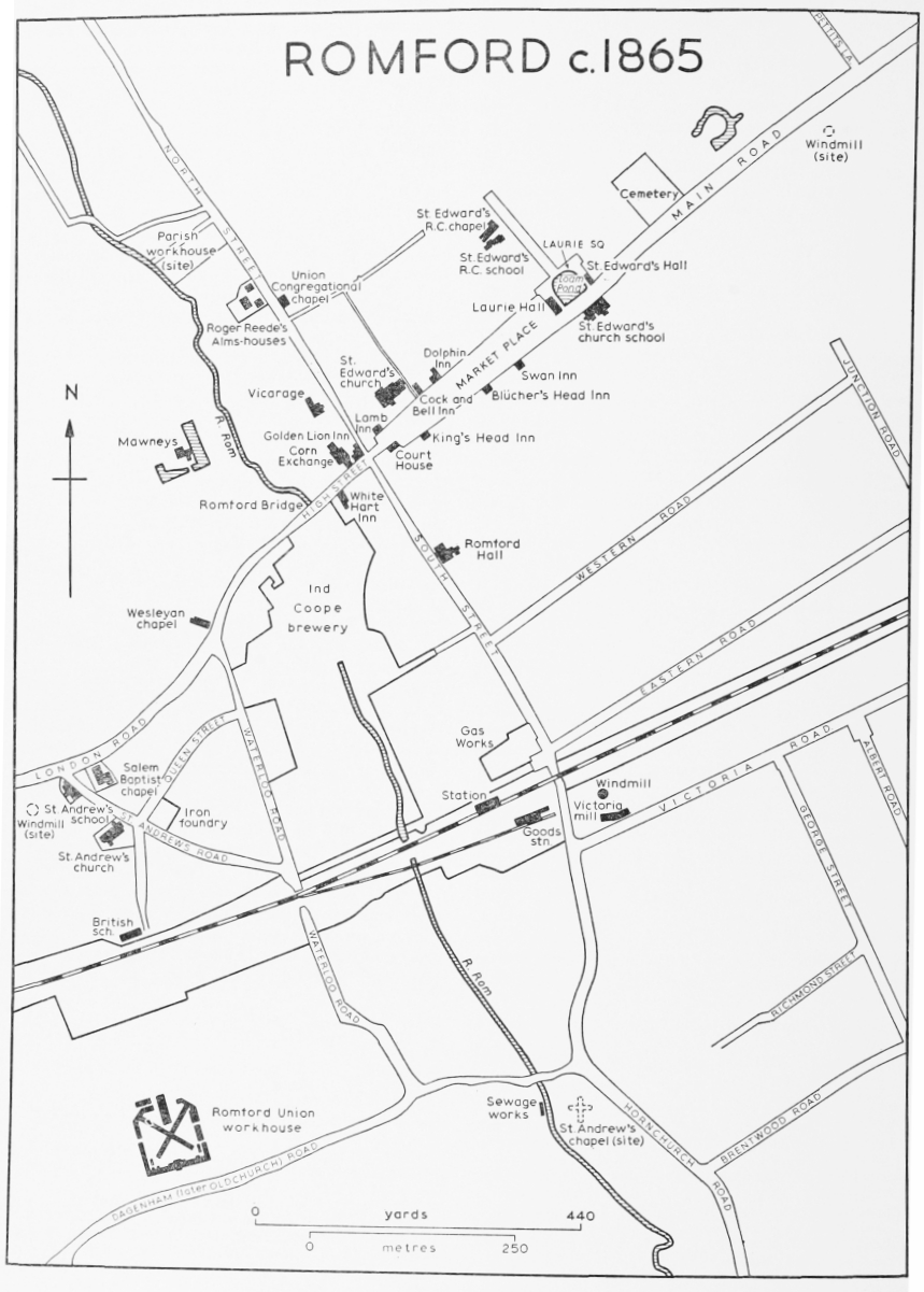
ROMFORD
Manors and other Estates, p. 64. Economic History, p. 72. Early Mills, p. 74. Market, Fair, and Corn Exchange, p. 75. Forest, p. 76. Local Government, p. 76. Public Services, p. 79. Parliamentary Represencation, p. 82. Churches, p. 82. Roman Catholicism, p. 87. Protestant Nonconformity, p. 87. Judaism, p. 91. Education, p. 91. Charities for the Poor, p. 96.
Romford, about 12 miles east of the city of London, is part of the London borough of Havering. (fn. 1) During the Middle Ages a small market town grew up here along the main London-Colchester road. Romford market still flourishes, but the old town has been engulfed by commuter suburbs stretching east to Gidea Park and north to Collier Row and Chase Cross. The large Harold Hill housing estate, built by the London county council in 1948–58, forms the north-east corner of Romford.
Romford, or 'Romford side', was a chapelry of the ancient parish of Hornchurch, containing five wards: town, Harold Wood, Collier Row, Noak Hill, and Havering. (fn. 2) It remained subject to Hornchurch for church purposes until the 19th century, but for civil purposes was virtually independent by the 16th century. Havering ward became independent for civil purposes in the later 17th century. A local board, later urban district council, was formed for Romford in 1851. The boundary of its district, several times altered, was in 1934 finally enlarged to 9,324 a., an area identical with that of the five ancient wards of Romford side. (fn. 3) The district became a municipal borough in 1937. In 1965 it was united with Hornchurch U.D. to form the London borough of Havering.
The old town is about 50 ft. above sea-level, on the upper edge of the gravel terrace that rises from the Thames. Farther north, on the London Clay at Collier Row, the land rises to over 150 ft. The main watercourse is the river Rom, which flows south through Romford and Hornchurch to join the Thames as the river Beam. (fn. 4) The old town sometimes suffered from floods, notably that of 1888. (fn. 5) By 1936 much of the Rom at the town centre had been culverted. (fn. 6) The river Ravensbourne, a tributary of the Rom, flows south and west from Gidea Park. Weald brook, which is the boundary between Romford and South Weald, to the east, flows south into Hornchurch, continuing as the river Ingrebourne to the Thames. (fn. 7) Carter's brook, rising at Noak Hill, becomes Paine's brook, as it passes through Harold Hill to join the Ingrebourne. (fn. 8) The Loam pond formerly stood at the eastern end of the market-place. In the later 18th century Romford vestry sometimes met the cost of fencing it. (fn. 9) The pond was bought by the local board in 1871, and was filled in in 1874. (fn. 10)
Schemes for a canal from Romford to the Thames were canvassed several times in the 19th century. (fn. 11) Between 1875 and 1880 such a canal was actually started, but it was never finished. (fn. 12) Remains of it, near New Road on the Hornchurch-Dagenham boundary, were identified and partly excavated in 1972. (fn. 13)
The Roman settlement of Durolitum was probably at or near Romford, but its exact site is not known. (fn. 14) Most of the Roman remains found there have come from Collier Row, Noak Hill, and Harold Hill. (fn. 15) Romford, first recorded in 1153–4, (fn. 16) probably means 'wide ford,' from which the river Rom took its name by back-formation. (fn. 17) The chapel of St. Andrew, Romford, first mentioned in 1177, stood east of the Rom, on the south corner of Oldchurch Road and South Street. (fn. 18) In the 17th century an area of 34 a., extending west of the river for 660 yd. along the south side of Oldchurch Road, was occupied by 6 fields called ruin meadow, lower ruins, great ruins, and three little ruins. (fn. 19) There must have been a settlement there, including a number of stone or brick buildings. It is unlikely that it was, wholly or mainly, a medieval site, since masonry was rarely used in Essex between the 5th and 15th centuries, except in churches and other large buildings. Twelfth-century Romford may have stood west of St. Andrew's chapel, amid or beside the ruins of a Roman town (fn. 20); but the Oldchurch site has not been excavated, and no Roman or medieval remains, apart from the chapel, have been recorded there.
If the medieval nucleus of settlement ever was at Oldchurch it had ceased to be there by 1410, when St. Andrew's chapel was abandoned, and the chapel of St. Edward was built about ½ m. to the north, on the present site in the market-place, then a piece of roadside common at the east end of the town. (fn. 21) Romford had been given a weekly market in 1247, with an annual fair in 1250, (fn. 22) and the growth of the town along the main London-Colchester road probably dates from that period.
Until the 20th century Romford remained a small country town. In c. 1618 the urban area was confined to the market-place, High Street, the east end of London Road, and the south end of Woolford (now North) Street. (fn. 23) There were hamlets fringing the commons at Collier Row and Noak Hill, and on the main road at Hare Street (now Gidea Park). The face of the parish did not change much in the next 200 years. (fn. 24) The population has been roughly estimated as 1,345 in 1580, 1,485 in 1680, and 1,846 in 1735. (fn. 25) In 1670 there were 323 houses in Romford, of which 184 were in the town ward, 56 in Collier Row, 50 in Harold Wood ward (the present Gidea Park and Harold Hill), and 33 in Noak Hill. (fn. 26)
In 1801 Romford had a population of 3,179, occupying 522 houses. (fn. 27) In size and character it was then similar to Epping, another Essex market town with a busy coaching trade on a main road to London. (fn. 28) Unlike Epping, however, Romford was linked to a main railway line as early as 1839, and continued to grow steadily throughout the 19th century. The population increased to 5,317 in 1841, to 8,239 in 1871, and to 13,915 in 1901. After the First World War it grew rapidly, from 19,442 in 1921 to 35,918 in 1931, 88,002 in 1951, and 114,584 in 1961. (fn. 29)
The first large development in the 19th century was on the old barrack ground, south of London Road. The site comprised about 12 a., extending south to the railway. It was sold c. 1840, and during the next 15 years some 200 artisans' cottages and at least two factories were built there. (fn. 30) The area, which was known in the 1840s as New Romford, included Waterloo Road, St. Andrew's Road, and Queen Street. Since the Second World War it has been redeveloped with council flats.
At the other end of Romford, east of the market-place, the small middle-class suburb of Laurie town was built c. 1850 by John Laurie (d. 1864), a London saddler of Scottish descent who lived at Marshalls, Romford, from 1846 to 1864. (fn. 31) It originally included two public halls, St. Edward's hall and the Laurie hall, standing respectively east and west of the Loam pond, in St. Edward's (later Laurie) Square. On the north side of the square were four pairs of semi-detached villas. All those buildings were in existence by 1853. (fn. 32) A few more houses were built c. 1857 in Park End Road, north of the square. (fn. 33) When complete the square included, on its south side, a dwarf wall with ornamental pillars. (fn. 34) St. Edward's hall was demolished soon after John Laurie's death. (fn. 35) In 1874, when the Loam pond was filled in, the ornamental wall was also removed. (fn. 36) The centre of the square was converted into a public garden and war memorial in the 1920s. In 1965 the two pairs of villas on the NE. side of the square were demolished to make way for the new central library. The villas on the north-west side were removed in 1968, when St. Edward's Way was being built, and the Laurie Hall in 1970. (fn. 37) The site of the square then became a traffic roundabout, with pedestrian subways named Ludwigshafen Place, from the West German town (Rheinland Pfalz) which is 'twinned' with Romford.
A much larger development was undertaken in 1851 by the National Freehold Land Society, which had acquired the manor of Stewards, comprising some 200 a. on the east side of South Street, near Romford station. (fn. 38) By 1854 Western and Eastern Roads, and the southern end of Junction Road had been built, and many plots sold. Victoria Road was laid out c. 1855, and the first houses were erected there c. 1856–8. (fn. 39) Building started in Albert Road c. 1860, George Street c. 1864, Carlisle, Shakespeare, Milton, and Shaftesbury Roads c. 1866, and Richmond Street (now Road) c. 1869. (fn. 40)
Romford did not grow much in the 1870s, but in 1883 the manor of Mawneys, containing 265 a. north-west of High Street, was sold for building, which by 1889 was proceeding rapidly, and by 1899 stretched from Mildmay Road east to Linden Street, and from Marks Road north to Forest Road. (fn. 41) During the 1880s the manor of East House, north of the town, was also cut up for building, but progress there was slower, and as late as 1901 only 50 houses had been built, in Havering, Rosedale, and Hainault Roads. (fn. 42) North-east of the town the Hill Park estate, comprising Kingston, Erroll, and Gilbert Roads, was laid out in 1898–9, and at the same time Junction Road was extended to join Main Road. (fn. 43)
By 1900 Romford was also expanding westwards. The small Birkbeck estate, comprising Birkbeck, Grosvenor, Wolseley, and West Roads, at Rush Green, was being built by 1885. (fn. 44) The Shrubbery estate, lying between London Road and Sheringham Avenue, was developed c. 1899–1900. (fn. 45) Meanwhile the town was continuing to spread south and southeast. There was more building in Victoria Road, and at its eastern end Manor, Prince's, and King's Roads were laid out c. 1886. (fn. 46) By 1908 building had extended south to Clydesdale Road, while farther east, beyond the Romford-Upminster railway line, the large Heath Park estate was being developed. (fn. 47) The only large area near the town centre which had not yet been built-up was the Marshalls estate, comprising some 120 a. between North Street and Pettits Lane. That came on the market in 1924, and was developed during the following years. (fn. 48) The growth so far mentioned was nearly all within a mile of the old town and Romford railway station. Beyond that radius there was little urban building in the 19th century. At Prospect Place, in Collier Row Lane, a new hamlet, of about 30 cottages, occupied by artisans, was in existence by 1846. (fn. 49) Factory Road (now Elvet Avenue), Squirrels Heath, containing about 50 houses, was built about the same time for workers at the Eastern Counties Railway Co.'s tarpaulin factory. (fn. 50) It was redeveloped in 1964 with council flats in towers. (fn. 51)
ROMFORD c.1865
The Gidea Park garden suburb, built in 1910–11, was the most notable development in Romford up to that time. (fn. 52) In 1897 the Gidea Hall estate, containing some 480 a., had been bought by (Sir) Herbert Raphael, (Bt.) (1859–1924), of Rose Court, Havering, who earlier in that year had narrowly failed in his second attempt to secure election as Liberal M.P. for the Romford division. (fn. 53) He gave a strip on the western edge of the estate for a public park, opened in 1904. On the eastern side of the estate 90 a. were already occupied by Romford golf club, which he had founded in 1894. (fn. 54) In 1910 Raphael joined with two other Liberal M.P.s, Charles McCurdy and (Sir) Tudor Walters, to form Gidea Park Ltd., for the purpose of building a garden suburb on the remainder of the Gidea Hall estate. Gidea Park Ltd. had close links with the Hampstead Garden Suburb Co., in which Raphael, McCurdy, and Tudor Walters were all shareholders. (fn. 55) As originally planned Gidea Park garden suburb was to occupy about a square mile, extending east to Gallows Corner, and north to the present Rise Park. The company arranged with the Great Eastern Railway for the building of Squirrels Heath (now Gidea Park) station, and bought an additional 60 a. land, south of Main Road, to control access to it.
Gidea Park Ltd. offered to sell building plots or completed houses, to design houses for purchasers' requirements, and to provide 100 per cent mortgages. The foundation stone of the garden suburb was laid in 1910. The designs of the first houses were open to competition, and about 100 architects entered, including such well-known men as Barry Parker and (Sir) Raymond Unwin, M. H. Baillie Scott, T. Gordon Jackson, Philip Tilden, and Clough WilliamsEllis. By the following year 140 houses had been built. The first part of the suburb was laid out around Gidea Hall, between Raphael Park and Heath Drive. Most of the area south of Main Road was not formally included in the suburb, but a few houses were also built there, in Balgores Lane and adjoining roads. Nearly all the houses were detached. The competition was restricted to 'small houses' of 4 bedrooms, costing £500, and 3-bedroom 'cottages', costing £375. Stress was laid on convenient and labour-saving plans. Many of the houses were in Tudor styles, roughcast, colour-washed, or sometimes half-timbered. (fn. 56) The area was well landscaped, and the plots were of good size. There was a separate town planning competition for future development.
The Gidea Park garden suburb was not completed as planned. Eastern Avenue, the arterial road built in the 1920s, cut across the northern side of it. In 1934 Gidea Park Ltd. held another competition in an attempt to sell more building plots. (fn. 57) By that time Gidea Hall had been demolished. A small area east of the golf course had been laid out as Links Avenue and Hockley Drive. The golf course itself had been considerably enlarged, and a sports ground had been made adjoining Gallows Corner. Most of the plots offered for sale were along Eastern Avenue. Nearly 500 designs were entered for the competition, and 35 houses were built in Brook Road and the adjoining part of Eastern Avenue. The houses were divided into 5 classes, with prices ranging from £650 to £1,475. Those in the two cheapest classes were semi-detached. All were in contemporary styles, some being built of concrete, and most with flat roofs. In promoting the competition Gidea Park Ltd., though stressing architectural innovation, had abandoned the garden suburb idea, and their original town planning designs, referring always to the Gidea Park Estate, and proposing ribbon development along Eastern Avenue. Most of that development did not, however, take place, and there has been little building on the estate since 1934.
By the 1930s the area immediately south of the garden suburb was being rapidly built up, and the name Gidea Park was adopted for a ward of the town, comprising the area round the railway station. Some of the new building was by Gidea Park Ltd., which in 1934 was offering flats to let in Geddy Court, Hare Hall Lane, a large 4-storey block near the station. It was, however, in the north of the town that Romford's main development took place between the two world wars. Collier Row had been growing slowly since c. 1900, but was still largely rural until 1929, when 80 a. were released for building. By 1939 more than half the area of the ward had been built up, the peak year being 1937, when some 1,500 house plans were passed. (fn. 58) Romford's leading developer between the two world wars was Thomas England (d. 1960), who had started his business career as an assistant in a local chemist's shop. (fn. 59)
Schemes for further building in the north of the borough were checked shortly before the Second World War by the Green Belt legislation. (fn. 60) Since the war there has been more building, including some large borough council estates, at Collier Row, and farther east at Chase Cross and Rise Park, but the main area of growth has been Harold Hill, where in 1948–58 the London county council built some 8,200 houses, and some factories, on the former Dagnam Park estate. (fn. 61) The site had more natural variety than Becontree, (fn. 62) and two large areas of park-land were retained. The houses, most of which are of two storeys, semi-detached, or in short terraces, are notable for their restrained design and the frequent use of a dark red facing brick and plain tiles. (fn. 63) In the past five years there has been some further building in vacant corners of the estate. In the town centre a new shopping precinct, completed in 1972, has been built between the Market Place and Western Road.
Until the coming of the railways Romford's communications with the outside world depended mainly on the London-Colchester road, that part of which was maintained from 1721 by the Middlesex and Essex turnpike trust. (fn. 64) There were also lanes running south to Dagenham and Hornchurch, east via Squirrels Heath to Upminster, and north to Havering and South Weald. In 1814, when the commons were inclosed, new roads replaced the old tracks running east from Collier Row to Noak Hill, and south to Gallows Corner. Eastern Avenue, opened in 1925 as part of the arterial road from London to Southend, (fn. 65) ran through Romford about 1 mile north of the town centre. The old London road remained as a busy thoroughfare through the centre until 1970, when St. Edward's Way was opened as the northern section of a projected ringroad. (fn. 66)
Romford bridge, which carried the London road (High Street) over the Rom, was presented at the Essex sessions in 1627 as needing repair. (fn. 67) It was again presented there in 1648, when it was stated that the king was responsible for repair, but in 1649 the county ceased proceedings after learning that the inhabitants of the liberty of Havering were responsible. (fn. 68) In 1650 the tenants of the liberty claimed that the bridge had formerly been maintained by the Crown, and should now pass to the state. (fn. 69) It was apparently rebuilt c. 1737 at the cost of the Crown. (fn. 70) A new bridge, built in 1906, was reconstructed in 1921. (fn. 71)
There are also several minor bridges along the London-Colchester road. In 1768 they were recorded as Putwell, Paine's, and Romford Gallows bridges, in Colchester Road, Watermill bridge, in Main Road, Romford Gore and Pigtail Wash bridges in London Road. (fn. 72) Putwell (or Delle) bridge is reserved for treatment under South Weald. Paine's bridge was mentioned in 1567. (fn. 73) Watermill bridge, styled Watermen's bridge c. 1772, was rebuilt to the design of James Paine c. 1776, when Gidea Hall park was landscaped. (fn. 74) It became known in the 19th century as Black's bridge. In 1893 it was taken over by the county council. (fn. 75)
In the 1830s some 30 coaches called at Romford daily, travelling to or from London, Chelmsford, Colchester, Harwich, Bury St. Edmund's (Suff.) and other places. (fn. 76) The Eastern Counties railway from London was opened to Romford in 1839, extended to Brentwood in 1840, and Colchester in 1843. (fn. 77) Squirrels Heath, later Gidea Park, station was opened in 1910. (fn. 78) The line was electrified in 1949. The London, Tilbury, and Southend railway's line from Grays, opened to Upminster in 1892, was extended to Romford in 1893. (fn. 79) A separate L.T. & S., later L.M.S., station was built in South Street, opposite and linked with the G.E.R., later L.N.E.R. station. The two stations were amalgamated in 1934, the L.M.S. entrance and booking hall being closed and converted into shops. (fn. 80) At the beginning of the present century attempts were made to promote the building of tramways in Romford. (fn. 81) They were unsuccessful, but in 1912 the London General Omnibus Co. started services from Mile End to Romford. (fn. 82) There was a civil aerodrome at Maylands Farm, Harold Hill, for a few years up to 1937. (fn. 83)
Romford was a post town by 1687. (fn. 84) In c. 1790 the post office was at the Cock and Bell inn, Market Place. (fn. 85) It was in the market-place in 1838 and 1848, and in High Street by 1863. (fn. 86) In 1870 it was in South Street, where it has since remained. (fn. 87) A telegraph line was being installed in 1869. (fn. 88)
Little remains in Romford that is older than the 19th century. (fn. 89) Even before modern development began there had been much rebuilding. In the Middle Ages there were manor-houses on 12 sites; Mawneys, Stewards, Marshalls, East House, and Gidea Hall were in or near the town, Wrightsbridge at Noak Hill, Dagenhams, Cockerels, and Gooshayes at Harold Hill, Risebridge near Chase Cross, Gobions at Collier Row, and Marks on the northwest boundary. In 1976 there were houses on only three of those sites: Gobions and Risebridge, both rebuilt in the 19th century, and Wrightsbridge, rebuilt in the 18th century and remodelled c. 1920. Adjoining Wrightsbridge, however, is the former Little Wrightsbridge, now Angel Cottages, which dates from the late 14th or early 15th century, and is Romford's oldest surviving building. (fn. 90) Of the other large domestic buildings known to have existed before the 19th century only five survive. Crown Farm, formerly Pigtails, London Road, is a late-16th- or early-17th-century house extended at the back and re-arranged internally in the later 18th century; further additions, for service rooms, were made in the earlier 19th century. (fn. 91) Widdrington Farm, formerly Wolves and Joyes, Church Road, Noak Hill, stands on a medieval site. (fn. 92) It retains a timber-framed cross-wing of the 17th century, but the main range appears to have been reconstructed in the 18th century, and the whole building was encased in brick and re-roofed in the 19th century. Maypole Cottage, Collier Row Road, is a timberframed house of the late 17th or early 18th century. The Morris Dancer, formerly New Hall, Melksham Close, Harold Hill, is an early-18th-century brick building now serving as a public house.
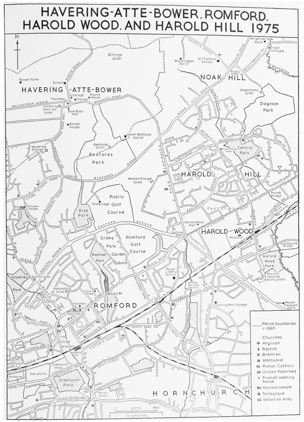
HAVERING-ATTE-BOWER, ROMFORD, HAROLD WOOD, AND HAROLD HILL 1975
Hare Hall, Upper Brentwood Road, Gidea Park, now part of the Royal Liberty school, stands on the site of an earlier house called Goodwins. It is a small Palladian mansion built in 1768–9 by John A. Wallenger to designs by James Paine. (fn. 93) The main, north front is of five bays, with a rusticated basement storey, above which the two upper storeys are unified by a giant attached portico and pilasters at the angles. Attached to the south front by short corridors there were pavilions containing service rooms. The principal rooms were on the first floor, and were approached by a central staircase with curved ends and an iron balustrade. The main front was of Portland stone, but the south front was of red brick, and in 1896 the house was considerably enlarged on that side by filling in the space between the pavilions. The Royal Liberty school was opened at Hare Hall in 1921, and in 1929–30 new red-brick buildings were erected to the south of the old house, forming a quadrangle. Nothing remains of the landscape designed by Richard Woods in 1771.
Among the more important old houses which have disappeared in the present century, and of which there are dated descriptions, were Lowland's Farm, London Road, Hawkins atte Well, Pettits Lane North, both of the 17th century, and Bell House, Rush Green Road, of the late 16th. (fn. 94) Several other old houses, possibly dating from the 16th century, still survived c. 1880. They included Familiarum, later Canons, North Street, and London House, Market Place. (fn. 95)
Small houses built before c. 1800 have survived in somewhat larger numbers. In the town there are several in North Street and at the east end of the market-place. The oldest of them, now nos. 98 and 100 North Street, is a timber-framed building of the late 17th century. At Gidea Park nos. 202–10 Main Road, also timber-framed, are a group of cottages of the late 18th or early 19th century, surviving from the hamlet of Hare Street. There are a few other cottages of that period in Noak Hill Road, Noak Hill.
As a market town on the main London Road Romford had many inns. In 1686 those in the town contained beds for 139, and stabling for 404 horses, and those at Hare Street 18 beds and stabling for 38. (fn. 96) In 1762 there were 22 licensed houses in the town and 3 at Hare Street. (fn. 97) Of those in the town only the Golden Lion, formerly known as the Lion or the Red Lion, still functions in its ancient buildings (fn. 98) The Lion existed in 1440, and there are later references from 1501. (fn. 99) The building, which is largely timber-framed, has a short elevation to High Street, and a much longer one, with a visible jetty, to North Street. It is made up of at least three sections of various dates from the early 16th century to the early 17th. That next to the corner was formerly jettied on both streets, and has a carriageway entrance in High Street. The next section along North Street had a first floor gallery towards the west, where there was an open court. The remaining sections have been much reduced by fire, and much altered internally, but are probably latest in date. In the 18th century the High Street front was raised by one storey and given a new brick elevation, which was remodelled in the 19th century. The south end of the courtyard is now built over. Recent restoration has exposed much of the internal timber framing.
Three other ancient inns in the town continue in modern buildings. The White Hart, High Street, can be traced from 1489. (fn. 100) During the Civil War it was used for meetings of the Deputy Lieutenants and Parliamentary Commissioners. In the later 18th century public entertainments were held in the White Hart assembly room. (fn. 101) The inn was rebuilt in 1896. The King's Head, Market Place, existed in 1678. (fn. 102) It is said to have been rebuilt in 1714 and again in 1898. (fn. 103) In 1971 the inn was moved to new buildings in the Liberty. (fn. 104) The Lamb, Market Place, mentioned in 1681, was rebuilt in 1852–3 after a fire. (fn. 105) The Cock and Bell, formerly the Chequers, Market Place, is no longer an inn, but its 16thcentury building survives as Church House. (fn. 106)
The Angel, which dated from 1488 or earlier, (fn. 107) and the Crown, recorded from 1620, (fn. 108) both in High Street, still existed in 1762, but had gone by 1864. (fn. 109) The Coach and Bell, also in High Street, was recorded by that name from 1694, and was probably identical with the Bell, mentioned in 1595 and 1631. (fn. 110) It was rebuilt in 1895 and demolished in 1956. (fn. 111) The Dolphin, Market Place, recorded from 1630, was closed in 1890 and demolished in 1900. (fn. 112) The Swan, or White Swan, Market Place, existed in 1468. (fn. 113) Its history has been traced from 1598 until 1967, when it was demolished. (fn. 114) The inn signs of the Dolphin and the White Swan are in Havering reference library, Romford. The Duke of Wellington, Market Place, was demolished in 1967. (fn. 115) Until 1914 it was the Blücher's Head, a name which had presumably been adopted c. 1815. (fn. 116) The Queen's Head, Market Place, was mentioned in 1732, but was not among the licensed houses in 1762. (fn. 117) The building still existed c. 1908 as Charles Ellingworth's dining rooms. A writer at that time thought that it was probably identical with the Queen's Arms, mentioned as the lodging of pretty Bessie in the Elizabethan ballad of the 'Blind Beggar's Daughter of Bethnal Green'. (fn. 118) In 1599 the comic actor William Kemp spent two days at a Romford inn, not named, during his morris dance from London to Norwich. (fn. 119)
At Hare Street, now Main Road, Gidea Park, the Ship and the Unicorn both existed in 1762. (fn. 120) The buildings of the Ship date from the later 16th or 17th century, though much altered. (fn. 121) The Unicorn, mentioned in 1679, and later, has been rebuilt in modern Tudor style. (fn. 122) In 1762 there were 5 inns at Collier Row and 3 at Noak Hill. (fn. 123) The Bear, Noak Hill Road, Noak Hill, was formerly the Goat, and was given its present name in 1715. (fn. 124)
During the agrarian boom of the mid 19th century many farm-houses in Collier Row, Harold Wood, and Noak Hill wards were built or rebuilt. At the same time those areas, still rural but within a mile or two of Romford station, were attracting the gentry, and wealthy business men working in London. (fn. 125) Notable among the new farm-houses was Heaton Grange, Straight Road, built c. 1815 by John Heaton, rebuilt c. 1905, and demolished c. 1955. (fn. 126) Another example, still surviving as a community centre at Harold Hill, is Red House, North Hill Drive, built in 1873. (fn. 127) Lawn House, Lawnsway, Collier Row now Lawn social club, was built c. 1850, apparently by the owner of the adjoining windmill, and was soon enlarged into a gentleman's residence, in a small park. (fn. 128)
Harold Wood Hall, Neave Close, Harold Hill, was built c. 1847, perhaps by William Heard, land surveyor, who was living there 1848. (fn. 129) Later occupants included Alexander Croll, c. 1859–63, William George, c. 1876–8, and Edward Bryant, c. 1890–1926. (fn. 130) Harold Wood Hall is now (1976) a mental health day centre of Havering L.B. It is an Italianate villa of double pile plan with a main front of 5 days. Late in the 19th century it was extended at both ends, and the interior was extensively refitted. A small building in the grounds, used as an elementary school, c. 1859–76, and as a nonconformist chapel, c. 1861–82, no longer exists. (fn. 131) The Priory, later called Dagnam Priory, Wrightsbridge Road, Noak Hill, was built c. 1840 in a curious mixture of Gothic and Tudor styles. (fn. 132) It was demolished in 1956. (fn. 133)
Until the 19th century Romford's principal public building, apart from the church, was the court house of the liberty of Havering, which stood at the west end of the market-place. It was demolished in 1933. (fn. 134) The parish workhouse, North Street (1787), and the Corn Exchange, High Street (1845) have also been demolished, as well as St. Edward's Hall and the Laurie Hall, already mentioned, but Romford union workhouse (1838) survives as part of Oldchurch hospital. (fn. 135) Romford county court, South Street, built in 1858, was demolished in 1936. (fn. 136) Modern public buildings include the town hall (1937), and the central library (1965), both in Main Road.
During the 17th century military musters were often held at Romford. (fn. 137) Troops were stationed in the town during and after the Civil War, and occasionally later. (fn. 138) In 1795, during the Revolutionary War with France, barracks for six troops of cavalry were built in London Road. (fn. 139) They were demolished c. 1825. (fn. 140) The Havering company of volunteer cavalry was raised c. 1802 for service in the Napoleonic Wars. (fn. 141) The Romford rifle volunteers were formed in 1859. (fn. 142)
The Liberty of Havering and district association for the protection of property and the prosecution of felons was founded in 1835. (fn. 143) Its area was gradually extended, and by 1933, when there were about 50 members, included places as far apart as Woodford and West Thurrock. The association, which met at Romford, prosecuted offenders against its members and offered rewards to persons helping to obtain convictions. It eventually became an exclusive club of farmers and tradesmen, popularly known as 'the Felons', but it never entirely abandoned its original aims. It was wound up in 1941 or shortly after.
Romford literary and mechanics' institute, founded in 1848, survived for about 40 years. (fn. 144) Romford philanthropic theatre, which in 1831 played for a summer season in the town, contained professional actors as well as amateurs. (fn. 145) The Laurie cinema, at Laurie hall, was opened in 1913 and closed in 1939. (fn. 146) By 1937 there were two other cinemas in the town, and another was being built. (fn. 147) In 1951 there were four in the town and another at Collier Row, but by 1971 only two survived, the Odeon, and the A.B.C. (threein-one), both in South Street. (fn. 148)
Horse races were being run at Romford in 1758. (fn. 149) Occasional race meetings were also held there in the 1840s. (fn. 150) The Priory polo club, founded in 1887, played at Dagnam Priory, Noak Hill, until 1895, when it moved to Hutton. (fn. 151) Romford cricket club, founded 1862, still survived in 1971. (fn. 152) Romford football club, founded in 1929, soon became one of the leading amateur clubs. (fn. 153) Romford golf club, Gidea Park, was founded in 1894, (fn. 154) and Maylands golf club, Harold Park, in 1937. (fn. 155) Romford swimming club was founded in 1902. (fn. 156) Romford greyhound racing stadium, London Road, was opened near the Crown hotel in 1929. (fn. 157) The present stadium, on the opposite side of London Road, was opened in 1933. In 1974 some 70 sports clubs were meeting in Romford. (fn. 158) At that date there were also about 50 cultural and recreational societies, with activities ranging from wine-tasting to war games, and from morris dancing to the study of underground railways. That number does not include societies meeting in Hornchurch, many of which were available to Romford people, or religious, political, trade, or professional bodies. Romford historical society, founded in 1956, has since 1968 been publishing an annual journal of local history.
Among persons connected with Romford were Sir Anthony Cooke (d. 1576) of Gidea Hall, politician, religious reformer, and tutor to Edward VI, and his learned daughters, Mildred, wife of William Cecil, Lord Burghley, and Katherine, wife of Sir Henry Killigrew. (fn. 159) Seventeenth-century figures included Francis Quarles (d. 1644), of Stewards, poet, (fn. 160) Laurence Wright (d. 1657), physician, of Dagenhams, Joachim Matthews (d. 1659), of Gobions, Parliamentary colonel and M.P. for Maldon, (fn. 161) and William Mead (d. 1713), Quaker, of Gooshayes. In the 18th century Gloster Ridley (d. 1724) and his son James Ridley (d. 1765), both writers, were successively curates of Romford. (fn. 162) Humphry Repton (d. 1818), landscape artist, lived at Hare Street, in a house at the corner of Balgores Lane which was long known as Repton Cottage. (fn. 163) Anthony Grant (d. 1883), vicar of Romford, and archdeacon of St. Albans, was for many years an influential local figure. (fn. 164) Thomas Bird (d. 1900) was a keen antiquary as well as chairman of the local board. (fn. 165) A. Bennett Bamford (d. 1939), topographical artist, lived at Romford for the earlier part of his life. (fn. 166) Arthur S. Hunt (d. 1934), papyrologist, was born at Romford Hall. (fn. 167) Kenneth Farnes (d. 1941), Essex and England cricketer, was brought up at Gidea Park. (fn. 168) Two conspirators are supposed to have plotted at Romford: Thomas Blood (d. 1680), who stole the Crown jewels, (fn. 169) and Christopher Layer, Jacobite, who was executed in 1723. (fn. 170) John Wilson (d. 1799), butcher of Romford, was notoriously fat. (fn. 171)