A History of the County of Essex: Volume 7. Originally published by Victoria County History, London, 1978.
This free content was digitised by double rekeying. All rights reserved.
'Romford: Local government', in A History of the County of Essex: Volume 7, ed. W R Powell (London, 1978), British History Online https://www.british-history.ac.uk/vch/essex/vol7/pp76-82 [accessed 30 April 2025].
'Romford: Local government', in A History of the County of Essex: Volume 7. Edited by W R Powell (London, 1978), British History Online, accessed April 30, 2025, https://www.british-history.ac.uk/vch/essex/vol7/pp76-82.
"Romford: Local government". A History of the County of Essex: Volume 7. Ed. W R Powell (London, 1978), British History Online. Web. 30 April 2025. https://www.british-history.ac.uk/vch/essex/vol7/pp76-82.
In this section
LOCAL GOVERNMENT.
The manorial government of Romford is treated above. (fn. 1) Romford, like Havering, was originally a chapelry of Hornchurch. By the 16th century Romford chapel vestry was virtually independent for civil purposes, governing Romford town, Collier Row, Harold Wood (or Hare Street), Noak Hill, and Havering wards. (fn. 2) By the late 17th century Havering chapel vestry had gained control over Havering ward for civil purposes, (fn. 3) and Romford vestry thenceforward governed only the town, Collier Row, Harold Wood, and Noak Hill wards. (fn. 4)
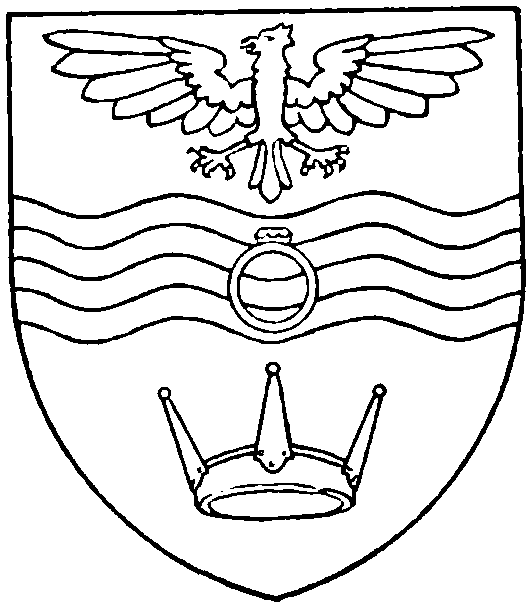
Romford Municipal Borough. Azure, on a fesse wavy, barry wavy of four, argent and azure, between in chief an eagle displayed and in base a Saxon crown, or, a ring also gold, gemmed proper.
[Granted 1938]
There are Romford vestry minutes from 1660 to 1924. (fn. 5) The oldest surviving book includes a few extracts from earlier parish books going back to 1490. There are also rate books for 1802 and 1829–36. (fn. 6)
By 1662 Romford vestry was meeting monthly to deal with poor-relief. (fn. 7) There are occasional later references to monthly meetings, although the vestry minutes record only the most important meetings. Attendance, as indicated by signatures to the minutes, was usually between 7 and 14 until after 1810, when figures of 12 to 16 or more were normal. Carew Hervey alias Mildmay (d. 1676) and his son Francis Hervey Mildmay (d. 1703), successive owners of Marks, often attended the vestry, and nearly always signed first. (fn. 8) Between 1660 and 1769 the chaplain of Romford usually attended. James Hotchkis, 1706–34, and his successors customarily signed first. From 1770 to 1792 the chaplain was hardly ever present, and signatures suggest that one of the churchwardens presided. Between 1793 and 1836, when the chaplains were often non-resident, successive assistant curates usually took the chair.
Romford had two chapel-wardens. In the 17th and 18th centuries the vestry customarily elected one warden from the town and one from one of the 'upland' (i.e. rural) wards; each served for two years, with one retiring each year. The chaplains of Romford did not establish their right to appoint one warden until the early 19th century, although they attempted to do so on at least two previous occasions, in 1743 and 1768. Five collectors of the poor, including one for Havering, were appointed by Romford vestry in 1561. (fn. 9) In the earlier 17th century there were similarly five overseers of the poor, one for each ward. (fn. 10) From 1660 the town ward had two, so that there were six in all. From c. 1680 Havering nominated its own overseer. In the 1830s Romford vestry was appointing a paid assistant overseer. In the earlier 17th century there were usually two surveyors of highways, but occasionally one, three, or four. (fn. 11) In 1648 the number was fixed at three, and so remained at least until 1689. By the end of the 18th century there were apparently five: two from the town and one each from the other three wards. A high constable for the town, and five petty constables, two for the town and one each for Collier Row, Harold Wood, and Noak Hill, were appointed by ancient custom in the court leet of the manor of Havering. (fn. 12) Minor officers included the vestry clerk, beadle, sexton, dog-whipper, and a varying number of sidesmen. There are occasionally references also to a pewopener, and to a book-keeper.
Here, as at Hornchurch, there seem to have been separate rates for the different parish purposes, though there is little information concerning assessment before the 19th century. In 1660 the vestry adopted a series of resolutions proposed by the senior church warden, Nathaniel Beadle, with the aim of improving the financial administration of Romford. The churchwardens were directed to provide casual relief, presumably out of the churchrates, to relieve the poor-rates. An auditor of accounts was to be appointed, and illiterate churchwardens, if otherwise suitable for office, were to be provided with clerical help. The charity incomes were to be carefully administered, and the parish houses repaired. Beadle's plan was imperfectly realized, for in 1662, when he completed his term of office, his accounts were in confusion, and had to be subjected to a special audit. (fn. 13)
By the late 17th century Romford was well provided with charities, including Roger Reede's alms-houses. (fn. 14) There were also several poorhouses, which lay near the Loam pond in the market-place. One of them was said in 1660 to have been appropriated by the vestry after the death of its owner, a pauper named Mrs. Greenwood. (fn. 15) The others formed the endowment of Simpson's charity as well as accommodating poor people. There was also a pest house, at Collier Row. (fn. 16) In 1719 the vestry appointed a committee to prepare a scheme for a workhouse, and at the same time resolved to repair the Half Moon in Romford town, a house belonging to Ann Elsden's charity. These two measures may have been connected, for in 1753 the Half Moon was being used as the workhouse. (fn. 17) In 1765 the vestry used £55, part of the capital of Margaret Burch's and Joachim Matthews's charities, to build another poorhouse, possibly the one at Rush Green mentioned below.
The Romford Workhouse Act of 1786 transferred most of the responsibility for poor-relief in the 'parish' of Romford from the vestry to a new body called the directors and guardians of the poor. (fn. 18) The directors were, in the first instance, the 30 persons named in the Act, together with the chapel-wardens. Vacancies were to be filled by co-option from persons occupying premises rated at £10 a year or more. The directors were to hold quarterly general meetings, and weekly committees. They were empowered to appoint and to pay a clerk, a treasurer, and other officers. The overseers of the poor were still to be appointed, but their functions were limited to levying the poor-rate and relieving the casual poor, and even in those they were under the directors' control. The directors were required to establish a workhouse, and were empowered to borrow up to £3,500. The existing workhouse, and all the poorhouses belonging to the parish, including one recently built for the sick at Rush Green, were to be vested in the directors. The directors were authorized to punish misconduct in the workhouse without recourse to the magistrates, by 'moderate correction', confinement, hard labour, distinction in dress, or abatement in diet.
The directors immediately bought land in Collier Row Lane (North Street) and contracted with Abraham Godden and Richard Moore, bricklayers of Romford, to build a new workhouse, completed in 1787. (fn. 19) In 1788, they sold to Moore 8 parish houses near the Loam pond. (fn. 20) The new workhouse was used until 1836. Apart from a set of rules drafted in 1787 (fn. 21) there are no records of its administration, or of the other activities of the directors of the poor. It seems likely, however, that the Act of 1786 helped to keep down the costs of relief, which during the following decades rose much more slowly in Romford than in Hornchurch. (fn. 22)
In 1836 the chapelry of Romford became part of Romford poor-law union. Romford workhouse was used temporarily by the union from 1836 to 1838. (fn. 23) In 1840 it was demolished and the materials and the site were sold. (fn. 24)
An Act of 1819 set up a body of commissioners with power to levy rates, not exceeding 2s. in the pound annually, for paving, lighting, watching, and cleansing Romford town. (fn. 25) The vicar, all resident magistrates, and the surveyors of highways of Romford were to be commissioners ex officio. The Act named 24 other commissioners, and provided for the appointment of new ones, subject to a property qualification, to fill vacancies. The commissioners were empowered to employ paid officers, and to borrow on the security of the rates. The Act was to apply only to a small area, corresponding with the present town centre: Market Place, High Street, and adjoining areas of South Street and North Street. These limits were precisely defined, and there was no provision for their extension as the town grew. In 1848 the cmmoissioners' total expenditure was £468, including £108 contributed to the cost of the county police. (fn. 26) By that time the growth of Romford had begun to create slums at the west end of the town, and the vicar, Archdeacon Anthony Grant, organized a petition to the government calling for an enquiry into sanitary conditions. The enquiry provided ample evidence of the dangers to public health, (fn. 27) and in 1851 a local board of health of 12 members was set up, with responsibility for the whole parish of Romford. (fn. 28) In 1855, after complaints against the board, and another public enquiry, the government reduced the area of the board's district to include only the town ward of Romford. (fn. 29) The district was slightly extended in 1878. (fn. 30)
The local board met at St. Edward's Hall, Laurie Square (1851–3), and later at the old court house of Havering liberty, in the market-place (1853–69). (fn. 31) From 1869 until 1883 or later it leased a building in the market-place for offices and to house its surveyor. In 1892 the old court house was bought, with the market, from the lady of the manor, and this was subsequently used for municipal offices. (fn. 32)
The first chairman of the local board was the vicar, Grant, 1851–2. Between 1852 and 1873 the chair was successively occupied by six others of whom Edward Collier, miller, 1854–61, and Thomas Haws, farmer, 1861–5 and 1869–71, served longest. Thomas Bird, a manager at Romford brewery and a keen antiquary, was chairman of the board and of its successor the urban district council from 1873 until 1900. (fn. 33)
The members of the board served in rotation for three year terms. Most of them were tradesmen or farmers. Among others were William T. Jones, 1852–5, chaplain of Romford union workhouse, and William J. Skilton, 1866–9, rector of St. Andrew's. Both these clergymen joined the board as reformers; Skilton seems to have been the more successful in stirring the board to action.
The local board originally appointed a part-time clerk, a superintendent of roads, and a rate-collector who was also inspector of nuisances. In 1853 roads, rate-collecting, and nuisances were all entrusted to one man, but he was dismissed for embezzlement in the following year, and his duties were again divided between two officers. In 1865 the board first appointed a surveyor as its chief outdoor officer. During the 1870s two successive surveyors were dismissed for embezzlement, and a third for corruption. A part-time medical officer of health was first appointed in 1875, after pressure from the government.
The local board was at first slow and inefficient in dealing with the modest problems of a small town. The first sewage works, opened, after long delays, in 1861, was never satisfactory. (fn. 34) In its later years the board was more effective. The purchase in 1869 of Bretons farm, Hornchurch, for a new sewage works, showed foresight in allowing room for expansion. Another decision which proved wise was the purchase of the market rights from the lady of the manor in 1892. (fn. 35)
Under the Local Government Act, 1894, the local board was succeeded, in 1895, by an urban district council, also with 12 members. At the same time the parish of Romford was divided into two for civil purposes. (fn. 36) The new parish of Romford (Urban) was placed under the U.D.C., while that of Romford (Rural) remained part of Romford rural district. Later in 1895 Noak Hill was taken out of Romford (Rural) as a separate civil parish. (fn. 37) In 1900 the civil parish of Romford (Rural) was united with that of Romford (Urban) and included in Romford Urban District, while the U.D.C. was enlarged to 16 members, representing 5 wards. (fn. 38) In 1934 the civil parishes of Havering and Noak Hill were added to the urban district, and the number of wards was increased to 7, represented by 20 councillors. (fn. 39)
The U.D.C. continued to meet in the old court house until 1931, when it moved to temporary premises in South Street. It opened public baths (1900), and joined with Romford R.D.C. to build an isolation hospital (1901). The first public park, part of which was a gift, was opened in 1904. After the First World War, with the town growing rapidly, the U.D.C. expanded its administration and improved its services. (fn. 40) A separate finance department was set up in 1932. A full-time clerk of the council was appointed for the first time in 1933, and a full-time medical officer of health in 1934. The U.D.C. acquired several new parks and began to build council houses. It carried out important road works, notably the widening of South Street, and in 1934 combined with Hornchurch U.D.C. in a new sewerage scheme. (fn. 41)
Romford became a municipal borough in 1937, with 21 councillors, representing five wards, and 7 aldermen. (fn. 42) In the same year a new town hall, designed by Collins & Green of Bournemouth, was opened in Main Road. (fn. 43) The council was enlarged in 1952 to 24 councillors, for 8 wards, and 8 aldermen, and in 1953 to 27 councillors (9 wards) and 9 aldermen. (fn. 44) Before the Second World War most of the seats on the council were held by Independents or by the Romford Ratepayers' Association. (fn. 45) The Labour party, which had begun to win seats in the early 1930s, increased its representation in 1945, and from 1955 to 1965 controlled the council. (fn. 46) The Conservatives, who were officially represented for the first time in 1950, were the largest group from 1951 to 1955, and the second largest from 1955 to 1965. During the Second World War Romford suffered much bombing, mainly in 1940–41 and 1944–5. Most of the houses in the borough received some damage and there were 143 deaths. (fn. 47) After that war the borough council embarked on a series of major housing schemes, and at the same time provided municipal services for the new L.C.C. estate at Harold Hill.
THE LONDON BOROUGH OF HAVERING.
In 1965 the borough of Romford was joined with the urban district of Hornchurch to form the London borough of Havering, with an area of 29,650 a., and a population, estimated in 1976, of 242,000. (fn. 48) The borough council consists of 55 councillors, representing 20 wards, and 9 aldermen. Since its formation it has been controlled by a coalition between the Conservatives and the Ratepayers' Association, except between 1971 and 1974, when there was a small Labour majority. It has built a new theatre at Hornchurch, opened in 1975, and a shopping precinct at Romford, completed in 1972, and opened an 18-hole golf course (1972) at Risebridge farm, Chase Cross, and a sports complex (1975) in Lamb's Lane, Rainham. Its main offices are at the town hall, Romford.
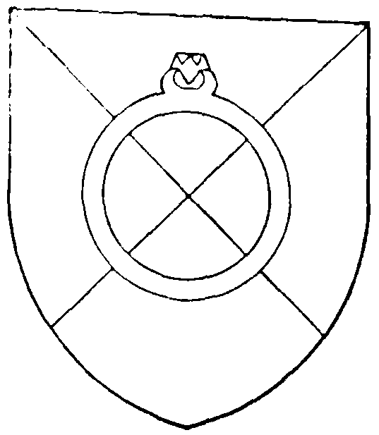
Havering London Borough. Per saltire argent and azure a gem ring or set with a ruby proper. [Granted 1965]
PUBLIC SERVICES.
Romford's first gas undertaking, with works in South Street, is said to have been established by George M. Bell in 1825. (fn. 49) In 1847 the Romford Gas & Coke Co. was formed and took over the works from Bell, who remained manager. (fn. 50) In 1892 the company built new works in Nursery Walk, south of the railway station; (fn. 51) by 1938 these covered 25 a. The rebuilding and enlargement of the works was begun in 1947. In 1949 the company was taken over by the North Thames gas board. (fn. 52)
The County of London Electricity Supply Co. obtained powers in 1913 to supply a large part of south Essex, including Romford, from a power station which was to be built at Barking. (fn. 53) This scheme was delayed by the First World War. In 1915, as a temporary measure, the company contracted to buy current from the private generators at Ind, Coope's Romford brewery, and used this to supply a small surrounding area. The company itself took over the operation of the brewery's generators in 1917, and maintained them until 1924, when a new sub-station was opened at Romford. The sub-station received supplies from the generators of Jurgens Ltd., margarine manufacturers, at Purfleet, in West Thurrock, until 1925, when Barking power station was opened. In 1948 Romford was placed under the Eastern electricity board. (fn. 54)
Romford had no main water supply until the later 19th century. The Loam pond, and the mineral springs at Havering Well and Gidea Hall, are mentioned elsewhere. (fn. 55) In 1859 the local board made a public well, with a pump, at the east end of the market-place. (fn. 56) The South Essex Waterworks Co., founded in 1861, began to lay mains in Romford in 1863. (fn. 57) The main offices of the company were transferred to South Street, Romford, in 1887. By 1905 the mains extended through the town in all directions, to Ilford, Collier Row, Ardleigh Green, Brentwood, and Hornchurch. (fn. 58) By 1936 the company had two deep wells in Romford, a covered reservoir at Heaton Grange, and a water tower at Havering. (fn. 59) The South Essex Waterworks Co. became part of the Essex Water Co. in 1970. (fn. 60)
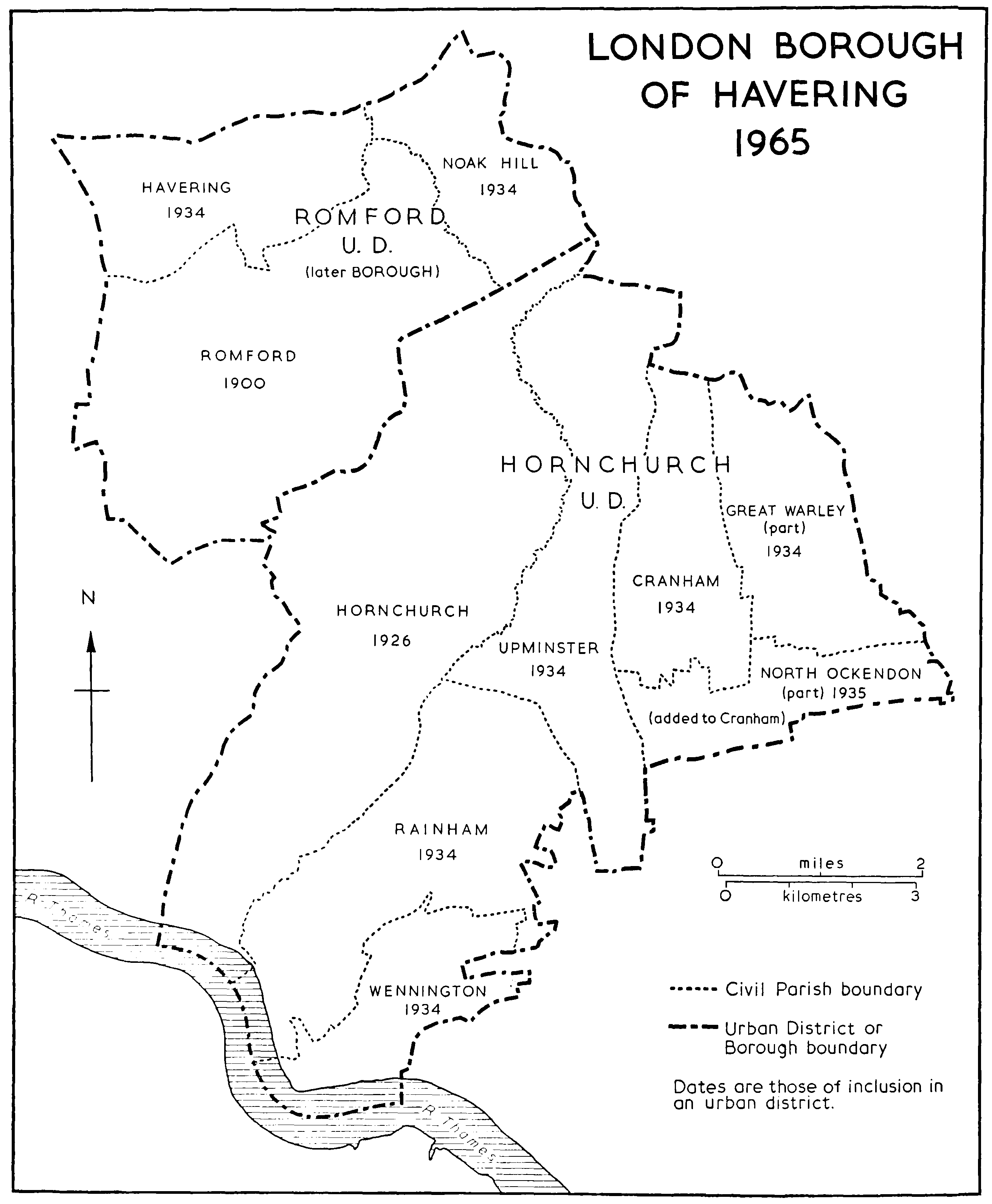
LONDON BOROUGH OF HAVERING 1965
Romford local board in 1852 drew up plans for main drainage, but took no steps to carry them out until 1858, when Dagenham parish successfully prosecuted them for polluting the river Rom. (fn. 61) Sewage works, at Oldchurch, were then put in hand, and were completed in 1862 at a cost of about £7,000. (fn. 62) They were badly sited and inefficient, and in 1869, after further complaints about the pollution of the river, the board bought Bretons farm, Hornchurch, and built new works there. (fn. 63) By 1881 nearly all the town was said to be connected to the main sewers. (fn. 64) As early as 1886 the local board agreed to allow parts of Hornchurch to drain into the Romford sewers. (fn. 65) In 1934 the urban districts of Hornchurch and Romford formed a joint sewerage committee, and during the following years the Bretons farm works were enlarged to serve both districts. (fn. 66) In 1965 responsibility for sewage disposal passed to the Greater London council, and the treatment of the sewage from Romford and Hornchurch was subsequently transferred to the Riverside works at Rainham Creek in Hornchurch. (fn. 67) The Bretons farm sewage works were closed in 1969. (fn. 68)
Raphael park, Main Road, formerly part of the Gidea Hall estate, was opened by Romford U.D.C. in 1904. (fn. 69) The original portion of 20 a., given by (Sir) Herbert Raphael, was later enlarged by purchase to 55 a. (fn. 70) After the First World War the U.D.C. acquired other parks, including Mawney (1928), of 28 a., Bedfords (1933), of 215 a., and Rise park (1937), of 23 a.; the last was given by Thomas England. (fn. 71) In 1937 Romford had some 400 a. of public open spaces. (fn. 72) By 1960 the figure had risen to 640 a., which included Oldchurch park and two large parks at Harold Hill. (fn. 73)
The public baths, Mawney Road, Romford, were built by the U.D.C. in 1900, and modernized in 1937. (fn. 74) They were closed in 1974 and demolished in 1975. (fn. 75) The much larger pool in Gooshays Drive, Harold Hill, was planned by Romford borough council and opened by Havering L.B.C. in 1966. (fn. 76)
Romford vestry was maintaining a parish fireengine by 1787. (fn. 77) One or two engine masters were regularly employed. In 1805 they were empowered to recruit six firemen when required. (fn. 78) An engine house was built in the workhouse garden in North Street, apparently in 1823; this was retained when the workhouse was sold in 1840. (fn. 79) In 1852 the fireengine was taken over from the vestry by the newly formed Romford local board. (fn. 80) A volunteer brigade, supported by the local board, was formed in 1890. (fn. 81) The founder was Samuel Davis, a local builder. He captained the brigade for many years, and most of the firemen were drawn from his firm. (fn. 82) A new fire station was built in Mawney Road, near Davis's premises, soon after the formation of the brigade. (fn. 83) It remained in use until 1960, when Essex county council, which had taken over the brigade after the Second World War, opened a new station in Pettits Lane North. (fn. 84)
Romford U.D.C. began building council houses after the First World War, at Park farm, London Road, and later at Rush Green. (fn. 85) By 1939 the borough council had 358 houses. (fn. 86) Between 1945 and 1965 it completed a further 3,929, concentrated mainly at Collier Row, but including several other estates in the borough, and one outside it, at Hutton, in Brentwood urban district. (fn. 87) From 1965 Havering L.B.C. continued Romford's building programme and also took over from the Greater London council 2,600 houses at Harold Hill. By 1973 Havering owned over 8,000 houses in the Romford section of the borough. (fn. 88)
Victoria hospital, Pettits Lane, was opened in 1888 as a voluntary cottage hospital, on a site given by William Mashiter. (fn. 89) By 1937, after three enlargements, it had 31 beds. (fn. 90) Oldchurch hospital, Oldchurch Road, occupies the site, and includes the buildings of the former Romford Union workhouse. The original workhouse, designed by Francis Edwards, was built in 1838. (fn. 91) A hospital was added in 1893, and was enlarged in 1924. (fn. 92) On the dissolution of the poor-law union in 1930 the institution was taken over by the public assistance committee of Essex county council, which in 1935 transferred it to the public health committee. (fn. 93) Since 1930 Oldchurch hospital has been greatly enlarged. The original building of 1838 is of two storeys. The plan is a square enclosing a cross set diagonally. The main, south front is of 25 bays with the centre emphasised. There are later 19th-century buildings on the north side, but all these are dwarfed by the 20th-century hospital buildings on the north and east. Rush Green hospital, Dagenham Road, Dagenham, built in 1900 jointly by Romford U.D.C. and Romford R.D.C., as an isolation hospital, has been treated elsewhere. (fn. 94)
A parochial cemetery was opened about 1849 on a site of 1 a. in Main Road, originally intended for a new parish church. (fn. 95) This soon became full, and in 1871 Romford burial board, which seems to have been formed about two years earlier, opened a new cemetery in Crow Lane, Rush Green. (fn. 96) Romford U.D.C. took over the cemeteries in 1900. (fn. 97) The old cemetery in Main Road was in 1953 laid out as Coronation Gardens; the Romford war memorial was placed there in 1970 after being removed from Laurie Square to make room for the new ring road. (fn. 98)
Romford library, the first full-time branch of the Essex county library, was opened in 1930 in the former St. Edward's charity school in the marketplace. (fn. 99) Temporary branches were established at Havering and Collier Row before the Second World War. (fn. 100) After the war the county council built branch libraries at Hilldene Avenue, Harold Hill (1959), Balgores Lane, Gidea Park (1962), and Collier Row Road, Collier Row (1964). (fn. 101) It also built a large central library in Laurie Square, Romford. This was designed by the county architect, Mr. H. Connolly, in reinforced concrete clad with Empire stone, and cost £180,000. It was taken over by Havering L.B.C. and was opened in 1965. (fn. 102) The old market-place branch was then closed.