A History of the County of Hertford: Volume 2. Originally published by Victoria County History, London, 1908.
This free content was digitised by double rekeying. All rights reserved.
'Wheathampstead with Harpenden: Introduction', in A History of the County of Hertford: Volume 2, ed. William Page (London, 1908), British History Online https://www.british-history.ac.uk/vch/herts/vol2/pp294-297 [accessed 30 April 2025].
'Wheathampstead with Harpenden: Introduction', in A History of the County of Hertford: Volume 2. Edited by William Page (London, 1908), British History Online, accessed April 30, 2025, https://www.british-history.ac.uk/vch/herts/vol2/pp294-297.
"Wheathampstead with Harpenden: Introduction". A History of the County of Hertford: Volume 2. Ed. William Page (London, 1908), British History Online. Web. 30 April 2025. https://www.british-history.ac.uk/vch/herts/vol2/pp294-297.
WHEATHAMPSTEAD WITH HARPENDEN
Huuaethampstede, Watamestede, xi cent.; Wethamstede, xiii cent.; Wathamstede, xiv. cent.; cum Harpenden, Harpeden, xiii cent. to xvi cent.; Harden, xvii cent.
The old parish of Wheathampstead, now divided into the separate parishes of Wheathampstead and Harpenden, is situated at the north-west of the county on the Bedfordshire border. It is irregular in shape, being about six miles across from east to west, and about three from north to south. The parish before the division comprised 10,279 acres of land, and 19 acres of land covered with water, and in 1905 the parish of Wheathampstead consisted of 3,173 acres of arable land, 1,328 acres of permanent grass, and 115 acres of woodland, and that of Harpenden of 2,756 acres of arable, 890 acres of permanent grass, and 152 acres of woodland. (fn. 1) The River Lea runs from west to east through the parish; the valley in which it lies is about 270 ft. above the ordnance datum, and is formed by hills rising to a height of 400 ft. to 420 ft. above the same datum. The greater portion of the parish is undulating or hilly, and more nearly approaches the higher of the two levels mentioned. The subsoil is of chalk, and the upper soil of the hills on the western or Harpenden side is of clay with flints; eastward of Harpenden Common it is mostly of flint, gravel, and sand, with alluvial deposit in the valley of the Lea. Brick-earth, gravel, and chalk are worked, especially on and near to the extensive commons in the parish.
Wheathampstead Village
The land is mostly arable, and produces excellent wheat. It is well wooded, and the combinations of hill and valley, pasture, common, arable and woodland produce some pleasing and picturesque views. There are two parks in the parish—Rothamsted and Lamer—which are both well stocked with timber. The commons and greens are numerous and extensive. Harpenden Common is the largest, and at one time covered a very much greater area than it does at present; but notwithstanding the inclosures which have been continuously made since the thirteenth century, it is still of considerable size. (fn. 2) The rights over this common were the subject of a suit between the dean and chapter of Westminster and Sir John Lawes, lord of the manor of Rothamsted, about 1850; the matter was however compromised by a partition of the common between the parties, and about 1882 the dean and chapter sold their interest in the waste to the late Sir John Lawes. Horse-races are held here every summer on the Saturday before Epsom races, and golf is much played. Kinsbourne Green, where the kennels for the Hertfordshire Hunt are, lies about a mile north-west of Harpenden, and covers a considerable area. Gustardwood (Gusthamstedewode, xiv cent.), another very large common, lies to the north of the village of Wheathampstead, on high ground, where there is also a large golf club. Nomansland Common is now divided between the parishes of Wheathampstead and Sandridge. It was, at one time, as its name implies, extra-parochial, and was the source of frequent disputes between the monastery of St. Albans and that of Westminster, both claiming it to be within their respective parishes and manors of Sandridge and Wheathampstead. In 1427 the abbot of Westminster erected a gallows here, which the servants of St. Albans Abbey promptly destroyed. On another occasion the body of a shepherd, who had died on the common, was claimed for burial by the incumbents of both parishes, and in his haste to assert his right to bury the body, the rector of Wheathampstead neglected to let the coroner view it. (fn. 3) In 1429 an arrangement was come to by which both abbeys should have grazing rights over the common. In the early part of the nineteenth century horse-races were yearly run here.
There are many less extensive parcels of waste, such as Hatching Green (Hacche End Grene) in Harpenden, Marshall's Heath near Mackerye End, Bower Heath (Bourehethe) to the north-west of the parish, Down Green to the west of Wheathampstead, and others which were attached, probably, to the various hamlets and manors with which this parish abounded. There are still some open fields at Manland Common and elsewhere.
Three main roads run through the parish—Watling Street, on the western boundary; the road from St. Albans to Luton, which passes over Harpenden Common and through the village of Harpenden; and the road from the Watling Street in St. Albans to the Great North Road at Hitchin, which passes through the village of Wheathampstead. There are also numerous cross roads.
There are three railway stations in the parish, the principal, on the main line of the Midland Railway at Harpenden, opened on 1 October, 1868, and the others at Harpenden and Wheathampstead, on the Luton and Dunstable branch of the Great Northern Railway, opened in September, 1860.
The greater part of the population is engaged in agriculture. Straw hat-making is still carried on by women in the cottages, though the bulk of the work is done at the straw-hat factories, of which there are three at Harpenden and one at Wheathampstead. There are also factories for the manufacture of india-rubber and waterproof goods at Harpenden. Watercress is grown in the parish to some extent for the London market.
The most important undertaking is undoubtedly the Rothamsted Experimental Farm, begun on a small scale in 1834, and carried on systematically from 1843 by the late Sir John Bennet Lawes to ascertain the effect of chemicals as manures upon different crops and plants. In the latter year the late Sir J. Henry Gilbert became associated with Sir John Lawes, and by their joint enterprise the Rothamsted farms have become of world-wide renown. With the exception of Boussingault's station in Alsace, this is the earliest experimental station that has anywhere been founded. In order to ensure perpetuity of the experiments, Sir John Lawes, in February, 1889, set apart £100,000 with a considerable area of land and the laboratory, which were placed in the hands of trustees, and a representative committee of management was formed. (fn. 4) In 1893 a boulder of Shap granite, bearing an inscription, was erected by public subscription opposite the laboratory, to commemorate the completion of fifty years of continuous experiments.
In regard to older industries in the parish we have evidence of pottery works by the discovery of a fourteenth-century kiln, in 1892, to the north-east of Gustardwood. Some fragments of the pottery found in the kiln are now preserved at the Hertfordshire County Museum, St. Albans. In 1573 a potter was presented at the manorial court for taking clay from Harpenden Common for making pots. (fn. 5) Torpen, the potter, was, in 1733, presented for taking clay from Balmwell Wood in Harpenden. Brick-making was much practised in the early part of the eighteenth century, and in 1728 and 1742 persons were presented for digging chalk and clay for making bricks (fn. 6) on Nomansland and Harpenden Commons. In 1759 there were brick kilns on Nomansland Common, (fn. 7) and the industry still continues in the parish. Pickford Mill, in Harpenden, was, in the early part of the nineteenth century, a paper-mill. (fn. 8)
It is not known that a market was ever held in this parish, but on the Court Rolls of the manor there are orders for proclaiming estrays in the church and in the market-place (in foro). A 'statute fair' is held at Harpenden on 16 September, but by what authority is unknown. It was formerly for the hiring of servants, but is now only the resort of itinerant shows. Efforts have been made to have it discontinued.
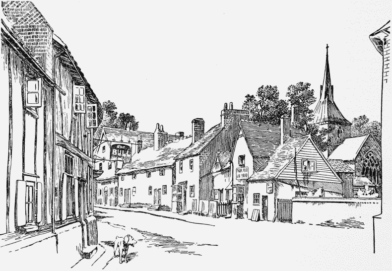
The village of Wheathampstead lies on both sides of the road leading from St. Albans to Hitchin, principally in the valley of the Lea, and on the steep hill which descends to the river on the south side. It is well wooded, and the approach from the south, looking down from the top of the hill, is very picturesque.
The older cottages and houses are half timbered with plaster work or pargeting, of which we find two forms of ornamentation, the zigzag and basketwork patterns, and are usually tiled. There are a few cottages built entirely of wooden boards, but the majority are of either red or Luton bricks, and slated or tiled. A few of them, built about the beginning of the nineteenth century, have the chequer pattern of black headers and red stretchers so frequently used in Hertfordshire.
Wheathampstead Place, or Place farm, as it is now called, is a red brick house of two stories, with gables, and a tiled roof with some fine Tudor chimney-stacks. It stands immediately to the north-east of the bridge crossing the river Lea in the village of Wheathampstead, and dates back to the time of Elizabeth, or possibly earlier, when it was the home of the Brockett family, whose monuments are in the church.
Wheathampstead House, the residence of the earl of Cavan, a little to the north of Wheathampstead Place, at the angle formed by the roads leading to Gustardwood and Codicote, is a modern house; the western wing is built of white brick, slated, with a battlemented turret on the south-west corner, and the eastern is of red brick and tiled.
Delaport is a small estate near Gustardwood. It took its name probably from James Delaport, who purchased land here in 1663. (fn. 9) It was held in the eighteenth century by the Sibley family, and now belongs to Mrs. Upton Robins.
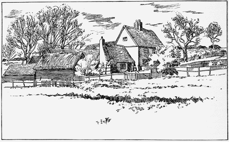
Creswell Farm, Wheathampstead
Creswell (Kerswell, 1388; Caswell, 1650) farm is a seventeenth-century farm-house, about a mile from Wheathampstead on the road to Batford Mill. It is of two stories, and is a plastered timber house, the older work being wholly covered with pargeting of basket-work pattern. The property formerly belonged to the Brockett family, and John Brockett appears to have retired to it after he sold Mackerye End. (fn. 10) It is now a portion of the Lamer estate.
Aldwickbury is an estate with a modern house on the road between Wheathampstead and Harpenden, and is now the residence of Mrs. Alfred B. Loder.
From an early date Harpenden has been a separate district or tithing for civil purposes, and Wheathampstead and Harpenden each had its own constable, beadle, ale-taster, and headborough, (fn. 11) or 'bosburg,' (fn. 12) as he is sometimes termed, elected at the abbot of Westminster's court-leet, and there have been separate churchwardens and registers for the parish church of Wheathampstead and chapel of Harpenden from the sixteenth century. As early as 1650 the commissioners appointed by the Parliament to inquire into the state of church livings (fn. 13) recommended that Harpenden should be made a distinct parish, and on 17 December, 1656, an order was made for its separation, tithe being allotted to each parish. We have no evidence that this order was carried out; if so, it was set aside at the Restoration, and Harpenden remained a chapelry till 1859, when it was finally separated, and 5,111 acres allotted to form the new parish.
The old village of Harpenden, which skirts the common, and lies scattered along the road leading from St. Albans to Luton, with the old houses and duck-pond on the east, and the tower of the church to be seen above the houses on the west side, still forms a pleasant picture. On account of its being on the main line of the Midland Railway, Harpenden has a largely increasing suburban population. The development of the parish as a residential district was facilitated by the placing upon the market, in 1882, of a large property known as the Pym and Packe estate, which included what is now the St. Nicholas estate, then the Church Farm, Park View estate, Manland Common, Couters End Farm, and smaller properties, much of which has been cut up into building sites and laid out in roads, along which detached and semi-detached houses have been erected. By an Order in Council under the Local Government Act of 1894, dated 10 February, 1898, Harpenden was formed into an urban district, with a council of twelve members.
There are several hamlets in the parish, viz.: Marford, on the Lea; Gustardwood; Amwell or Hamwell, on the south-west of Wheathampstead village; Bowling Alley, to the south-east of Harpenden, which takes its name probably from the game; (fn. 14) Cold Harbour, a mile to the north of Harpenden; and Kinsbourne Green.
Few antiquities have been discovered. Palaeolithic implements have been found in the gravel at Nomansland Common, and there are earthworks, (fn. 15) of probably the Celtic period, known as the Slad or Moat and the Devil's Dyke, to the east of the parish of Wheathampstead. A stone sarcophagus of the Romano-British period, containing a glass vessel and pottery, now in the British Museum, was found in 1827 in Mill Field, near Pickford Mill. (fn. 16) The remains of another Roman interment were found a little to the south-east of Harpenden station, on the Great Northern Railway, and some Roman coins in Harpenden churchyard. (fn. 17) An Anglo-Saxon glass bowl and a curious Frankish bronze pot of late sixth or early seventh-century work were found near Wheathampstead railway station, and the latter is now in the British Museum.
In 1312, after the death of Piers Gaveston, the barons stayed at Wheathampstead with their forces on their way to London, and it was here that they refused to receive the envoys and letter from the pope, demanding that the king, Edward II, should treat with them personally. (fn. 18) This parish was visited by the plague in 1667. (fn. 19)