Survey of London: Volume 26, Lambeth: Southern Area. Originally published by London County Council, London, 1956.
This free content was digitised by double rekeying. All rights reserved.
'Kennington: Introduction and the demesne lands', in Survey of London: Volume 26, Lambeth: Southern Area, (London, 1956) pp. 18-31. British History Online https://www.british-history.ac.uk/survey-london/vol26/pp18-31 [accessed 25 April 2024]
In this section
CHAPTER I - Kennington

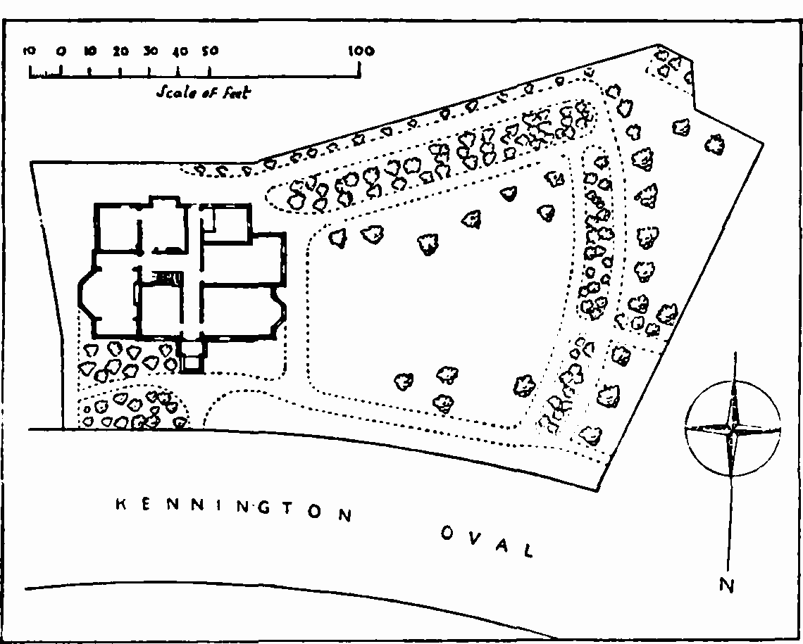
Key map of part of Kennington Manor. This map is based on Hodskinson and Middleton's survey of the Manor in 1785; the broken lines show the modern street plan. The names of the owners or lessees in 1785 are given below, against the numbers of the plots ringed in the map.
The whole of the part of Kennington which falls within the scope of the present volume is a section of the Duke of Cornwall’s Manor of Kennington. Much of the early history of the Manor has been traced in Volume XXIII of the Survey of London, and it is only necessary here to consider in detail the development of the roughly triangular section of the Manor, bounded by Kennington Lane, the line of Vauxhall Creek (also known as the River Effra), Kennington Common and Kennington Park Road, which is shown on the key map in fig. 3. Material for the history of the Manor is extensive. An incomplete survey made in 1554 (fn. 1) deals primarily with copyhold land. Other surveys were made in 1615 by John Norden, (fn. 2) in 1636 by Sir Charles Harbord dealing only with the demesnes, (fn. 3) in 1649 (fn. 4) and 1652 (fn. 5) by order of Parliament, and by John Hodskinson and John Middleton in 1785–6. (fn. 6) Of these surveys, Norden’s, Harbord’s, and Hodskinson and Middleton’s (the last two accompanied by maps which are reproduced in Survey of London, Vol. XXIII, Plates 1 and 2) are the most useful and are constantly referred to in the following text. The enrolments in the Manor court and the correspondence between the officers of the Duchy of Cornwall and tenants of the Manor preserved at the Duchy Office in Buckingham Gate are invaluable for the detailed history of development, and many of these sources of information have been gathered together in E. R. L. Clowes’ excellent though unpublished History of the Manor of Kennington. (fn. 7)
The part of the Manor covered by this volume falls naturally into two sections, south-western and north-eastern, divided by Kennington Road. In 1636 there were few buildings on either section. A single house stood on copyhold land in the south-western section near the site of the present Windmill public house. In the north-eastern section a house called the Buckshorns stood in Kennington Park Road, and there were a few buildings scattered along Kennington Lane. The general impression of the Manor at this date is of an area of meadow and pasture chequered by drainage channels. Kennington Lane, Which bounds the part of the Manor under consideration, follows much the same line today as it followed in 1636. At that date, the section of the Lane between South Lambeth and Kennington Roads was known as the Kingston Road and the section leading into Newington Butts as the “Sohowe” later these were known as Upper and Lower Kennington Lane respectively. The names “Upper” and “Lower” were abolished and the houses renumbered in 1936. (fn. 8)
Between 1636 and the publication of Rocque’s map in 1745, (fn. 9) the appearance of the Manor had changed little; Ketleby’s Rents had been built at the junction of Kennington Lane and Newington Butts, and a few houses lay thinly scattered along Kennington Lane. Within twenty years, however, the Manor began to assume its modern pattern. The opening of Westminster Bridge in 1750 (fn. 10) and the building of Kennington Road under an Act of 1751, (fn. 11) brought an increasing volume of traffic through the Manor, and gave easy access to the cities of London and Westminster. The building of Blackfriars Bridge and its approach roads between 1760 and 1769 (fn. 12) made Kennington even more accessible and desirable as a place for country residence; and in the last quarter of the century the ancient manorial customs of both the demesne and the copyhold lands were modified to meet the requirements of building development.
Under the charter granted by Edward III in 1337 the lands of the Duchy of Cornwall were to be held by Edward the Black Prince and his heirs, the eldest sons of the Kings of England, and in default of such heirs they were to revert to the Crown until a son should be born who was heir apparent to the realm. The lands of the Duchy were therefore sometimes vested in the Sovereign and at other times in the Duke of Cornwall, and consequently their tenure being somewhat insecure, little encouragement was given to tenants to improve their property. In 1622 however, an Act of Parliament (fn. 13) permitted the Duchy to grant leases for a maximum of three lives, or for 31 years. In 1776 William Clayton, lessee of the demesne lands of Kennington Manor, obtained a private Act (fn. 14) enabling him to grant building leases and in the following year he obtained a new lease from the Duchy for a long term of 99 years dependent on three lives. (fn. 15) As regards the copyhold lands the Prince’s Council of the Duchy decided in 1791 that copyholders might be granted licence to demise their property for 99 years instead of the more usual 31 or 61 years. (fn. 16)
In the north-eastern section of the Manor described in this volume these more flexible arrangements resulted in the development of the relatively small parts of the demesne in the decade after 1777. The Cleaver, East and Crooke copyhold estates, containing nearly half of this section of the Manor, were also developed at this time, and when Hodskinson and Middleton produced their survey Opal Street (then Pleasant Row), Cottington Street (Mansion House Row) and Kennings Way (White Hart Row) had been laid out, and part of Stannary Street (Kennington Place) ran north-eastwards from Kennington Road; along each of these roads were groups of houses. Almost continuous lines of houses stretched along Kennington Lane and Kennington Park Road, which Elmes later described as “those merchant’s and sugar-baker’s boxes which crowd the sides of Clapham Road and Kennington Common”. (fn. 17) By the time that Horwood’s map was published in 1799, the modern pattern of this part of Kennington had been set, except for alterations on the East estate some sixty years later.
The south-Western section between Kennington Road and South Lambeth Road was developed more slowly than the other. Nearly all of it was low-lying and in constant danger of flooding from the tidal creek, and there was no ready access from the main roads. Hodskinson and Middleton’s survey shows only a few houses along Kennington Lane and South Lambeth Road, and a group of buildings at the junction of Kennington and Kennington Park Roads; the rest of the area was set out as nursery ground and pasture, with one or two buildings attached to the various holdings. An agreement of 1789 between William Clayton and Isaac Bates and a number of associates for the development of the demesne lands in this area initiated building, (fn. 18) and produced the laying-out of the Oval and its communicating roads. The financial difficulties of Sir Joseph Mawbey, who held a considerable proportion of the copyholds in this area, led to his granting a number of building leases at the end of the 18th and the beginning of the 19th centuries along the main road frontages of his property. The Mawbey property away from Kennington Lane and Kennington Road was not developed until the building of Harleyford Road under an Act of 1818, (fn. 19) when the pattern of the area was finally established.
By 1834, when the lease of the demesne lapsed on the death of Sir William Clayton and the Mawbey estate had been broken up, there was little room for further development, except on small pieces of land later used for the Vestry Hall and the houses at Kennington Cross. Soon Kennington ceased to be a semi-rural suburb and the value of the property in the area began to decrease. In 1856 Thomas Farmer wished to enfranchise his property, part of the former Crooke estate, and the Steward of the Manor admitted that “it cannot be denied that the Rentals of such a class of Property … are very uncertain and precarious”. The Duchy was not, however, prepared to concede that decreased rentals should be taken into account when assessing the Lord’s fine for enfranchisement, lest the future value of the estate might be disparaged. (fn. 20)
At the end of the 18th century, and for some considerable time afterwards, the Duchy of Cornwall did not exercise any close control over the standard of building which, being left to the discretion of the builder, was very mixed. The negotiations with Farmer are an indication of the changed attitude of the Duchy towards the Kennington estates during the second half of the 19th century. After 1850 a period of redevelopment began in the Manor, and the influence exerted by the Duchy was more rigid and direct than before. When the Lambeth Vestry wished to add another storey to the Vestry Hall, the Duchy would neither grant permission nor sell the land, as “an unsightly structure may take the place of the present edifice … and diminish the value of the Houses in the neighbourhood” (fn. 21) The same control was exercised in 1887 when Sir Gilbert East applied for a licence to demise the sites of Nos. 140—162 Kennington Park Road for rebuilding. The Duchy declined to grant a licence until plans for rebuilding had been submitted, and remained adamant despite East’s complaint that no builder would incur the expense of preparing plans without the promise of a licence. (fn. 22) The houses were not rebuilt.
The Duchy was not always restrictive in its influence. Redevelopment of the former Cleaver copyhold estate received its encouragement, (fn. 23) and on the demesne lands the practice of granting a lease determinable on one or more lives was abandoned in favour of a definite term of years, as an encouragement to improvement. The increasing power of the Vestries and the Metropolitan Board of Works over the formation of roads and the enforcement of building lines also affected the character of the area, notably on the East estate. In 1913–15 the Duchy itself carried out the redevelopment of the land (outside the area covered by this volume) in the angle between Kennington Lane and Sancroft Street, and achieved, in Courtenay Square at least, a standard of urban design that recalls the best work of the 18th century. The architects were the late Stanley Davenport Adshead, the first occupant of the Lever Chair of Civic Design in the University of Liverpool, and Stanley C. Ramsey. (fn. n1)
Since the abolition of copyhold tenure, the power of the Duchy has been supplemented by the increasing powers granted to Borough and County Councils for clearance, rehousing and town planning. A considerable amount of rehousing has already taken place in Kennington, and the blocks of flats on the north-east and south-west borders of the Oval have replaced the old houses.
THE DEMESNE LANDS
Most of the demesne lands in the part of Kennington Manor under consideration in this volume lay together in the south-western section of the Manor, and were bounded on the south-east by Kennington Park Road, and on the south by the Manor of Vauxhall. There were five closes, the Gallows Field, the Great Meadow, the Eight Acres, the Sluice Field, which took its name from a sluice on Vauxhall Creek approximately at the junction of Harleyford Road and the Oval, and the Little Field; together these were known as the Forty Acres. To the north-east lay the Six Acres, the Three Acres, the Three Acres pasture and the Two Acres, all of which lay between Kennington Lane and Kennington Park Road. These closes were all subsequently subdivided, probably during the Clayton leases of the demesne.
The Clayton family and particularly Sir William, the last Clayton to hold a lease of the demesne, had an important influence on the development of the Manor. Under the Act of 1622 (fn. 13) leases of the Duchy lands could be granted for a maximum of three lives, or for 31 years. Several leases of the demesne followed; that granted to Lord Moore in May 1661 was assigned to Robert Clayton (later Lord Mayor of London and President of St. Thomas’ Hospital) and John Morrice. In 1670 a new lease in reversion was granted to Clayton and Morrice, and from that time until the death of Sir William Clayton in 1834, the Clayton family retained their interest in the demesne. (fn. 24)
In 1776 William Clayton, realising that the value of his leaseholds in Kennington was rising rapidly, obtained an Act of Parliament to enable him to grant building leases. He believed “that many Persons would be willing to enter into Contracts … for the Purposes of building, or Improvement … and that if such Leases could be granted, the Estate would be considerably increased in the future Value and annual Rents thereof”. (fn. 14) In the following year he obtained through Sambrook Freeman, a Trustee of his marriage settlement, a new long lease for 99 years instead of 31 years, determinable on three lives, (fn. 15) to encourage development. In fact, development did not follow immediately, but it was well under way in the north-eastern section of the demesne by 1785.
The development of the demesne land in the south-western section of the Manor dates from articles of agreement made on July 1, 1789 between William Clayton, and John Harwood, plasterer, of Lambeth, Thomas Dickinson, plasterer, of St. John, Westminster, Isaac Bates, brickmaker, of Kennington, and Richard Wooding, surveyor, of Bouverie Street, London. In the agreement Clayton covenanted to make subleases to the other parties when they had built houses “not to be less in number than one hundred and ten”. (fn. 18) There was an attempt to provide an attractive layout of the area (Plate 40b), for the roadway round the Oval was laid out at this time, together with the roads linking it to Kennington Park and Kennington Roads, and in 1790 the lease of the Oval was granted to a market gardener (see below); the whole must have provided a pleasant retreat from the traffic along Kennington Park Road. The leases covenanted for were executed on March 1, 1797, (fn. 18) although the development of the demesne, as Horwood’s map of 1799 shows, was still far from complete. The house which was later adapted for St. Mark’s Vicarage was then standing, but even in 1824 there was vacant land on which St. Mark’s School could be built. It was not until 1845 that the Oval was taken over for cricket, and the modern pattern of the demesne lands set.
The Oval
Fig. 3, plots 1—6
In 1615, when Norden made his survey of the Manor, the site of the Oval was part of five closes containing 38 acres, bounded by the Common, the common watercourse (Vauxhall Creek), and the lands of John Groome, Edward Carpenter and William Cockerham; these closes were in lease to Richard Salter and occupied by John Hubbard. (fn. 7) By 1636 the tenement was held by Mrs. Marie Coxe, widow, (fn. 3) and in 1649 by George Coxe; (fn. 4) from about this date the five closes seem to have been known collectively as the Forty Acres. In 1667 John Morrice and Robert Clayton, the lessees of a considerable part of the Manor, (fn. 24) appear to have erected a brick wall on the Forty Acres for growing fruit. (fn. 25) The area remained in lease for horticultural purposes, for William Malcolm, who had a sub-lease dating from 1758 of the part of the demesne now crossed by Clayton Street and Bowling Green Street, was required to provide in addition to a money rent “one hundred of Asparagus in the Month of January in every Year”. (fn. 14) In 1785 the area of the five closes had been divided into three tenements, one occupied by Malcolm, another by Thomas Ellis, landlord of the Horns, and others, and a third by James and George Mitchelson; (fn. 6) this last included the greater part of the site of the Oval. The Mitchelsons’ tenement is described as six fields of meadow, pasture and nursery ground, together with an old brick dwelling house, barn, stable, seed shop and sheds. (fn. 6) In 1790, after the laying-out of the Oval roadway, the tenements were redivided. The Mitchelsons’ tenement now included only the area within the Oval, mostly taken from their old holding, but it also included part of Malcolm’s, and a new lease was granted for 64½ years. This lease was later assigned to John Archer, and after his death it was put up to auction in 1826 and purchased by the Rev. William Otter, minister of St. Mark’s and later Bishop of Chichester. (fn. 16) The Clayton interest having lapsed in 1834, Otter was granted a head lease of the property, described as nursery or garden ground, by the Duchy on January 8, 1835, for 99 years determinable on one life, (fn. 27) which was later extended to three lives. (fn. 28)
Otter’s purpose in buying the lease of the Oval was to provide a site for the minister’s house and, by building over the remainder, an endowment for the living; this appears to have been the first building project at the Oval. When the subject was laid before the Prince’s Council of the Duchy, one of its members, Lord Bexley, produced a “General Idea of Improvement”. He proposed to “Inclose an Oval of an Acre or an Acre and a half in the Centre, and plant it with Lime Trees, to form an open Grove, with Gravel Walks round and across it, under the Trees”. Apart from a roadway to the grove, the remainder was to be divided into 21 lots, one for the minister’s house and the remainder for cottage villas, which were to be of “a general similarity, tho’ not exact uniformity of appearance”. (fn. 26) With the lapse of negotiations over the minister’s house, the plan was, however, forgotten.
Otter found the nursery ground unprofitable and converted it into a market garden, but in 1836 he petitioned the Duchy for a building lease because “the market gardens in the immediate vicinity of London have gradually declined in value”. (fn. 29) The Duchy was prepared to accede to this request despite the advice of the surveyor, James Bailey, that the value of the surrounding property would be greatly decreased, as the Oval afforded “not only the advantage of a large, open space, for the free circulation of air; but, also, a pleasant and agreeable object … to look upon”. (fn. 29) A building plan made by Bailey at this date is preserved in the Duchy office; it shows a road running across the Oval from south-east to north-west, flanked by six pairs of houses, with other pairs facing outwards around the Oval roadway. Negotiations with Otter until his death in 1840, and thereafter with his Trustees, were continued. Another building plan (Plate 40a) was suggested, with a similar arrangement to Bailey’s first plan, but with more pairs of houses, this time arranged about a road running north-east to south-west. However, the Duchy’s terms were considered too high, and the Otter Trustees looked for another way of using the land. The last building proposal for the Oval was in 1851, when the Duchy proposed to promote a Bill in Parliament for building two crescents there; but at the instigation of the Prince Consort the plan was dropped and the Oval remained an open space. (fn. 30)
The Otter Trustees were at last successful in their search for a new use for the land; in March 1845 they reported that they were “desirous of letting it to a Gentleman who proposes to convert it into a Subscription Cricket Ground”. (fn. 31) The new lessee was William Houghton of Brixton Hill, President of the Montpelier Club. The Club was formed about 1840 and played on the grounds of the Bee Hive Tavern at Walworth; these were, however, required for building in 1844. Soon afterwards the Treasurer, W. Baker, and William Ward, M.P. (who had already helped to preserve Lord’s Cricket Ground from being built over) entered into negotiations with the Otter Trustees, nominating William Houghton as lessee. (fn. 32) The first cricket match appears to have been played in May 1845. (fn. 33) Considerable preparations had been necessary, for the Oval was “in a most ruinous condition and from the effluvium arising from decayed vegetables a nuisance and a source of ill-health”. (fn. 31) In the spring of 1845, ten thousand turves from Tooting Common were laid. (fn. 34) Trees still studded the ground and in 1847 permission was given for some of them to be cut down. (fn. 31)
The Montpelier Club did not flourish at the Oval, (fn. 35) for Houghton’s interest in it waned once he became lessee. Meanwhile, the Surrey Club (later the Surrey County Cricket Club) had been founded in the autumn of 1844 at a meeting held at the Horns Tavern. (fn. 34) While the Montpelier Club declined, the Surrey Club grew in strength, and has played at the Oval ever since its foundation, at first sharing the ground, and later becoming its sole lessee.
Although the cricket ground was immediately popular, Houghton got into financial difficulties, and attempted to solve them by introducing other attractions. After many protests that the sale of liquors would be his only source of profit, the Duchy gave permission, subject to annual review, for one of the buildings to be used as a licensed house, the precursor of the Surrey Tavern. Permission to apply for the licence was withdrawn in 1853, after complaints of rowdyism, (fn. 31) and it was only after Houghton had ceased to be lessee that the Tavern was established as a permanent feature of the ground. Houghton also attempted to provide other sport, and in 1851 he was allowed to introduce “Pedestrianism and Coursing”. The pedestrianism involved a walking match of 1,000 miles in 1,000 hours. After the owners of neighbouring premises had objected, the Duchy’s permission was withdrawn, despite Houghton’s assurance that no disturbance had been caused, and that the public had not been “admitted on Sundays, and the Pedestrian on those days always walked in dark clothes”. (fn. 31) The Duchy also declined to allow an exhibition of poultry on New Year’s Day 1853, although 900 pens had been entered and the exhibition had distinguished patrons; (fn. 31) it was removed to a bazaar in Baker Street. (fn. 36) William Houghton’s difficulties were such that in 1854 he assigned the lease to his brother George in settlement of a debt; (fn. 36) and in the following year a new lease was granted to the Surrey Club by the Otter Trustees. (fn. 37) William Houghton became bankrupt, and his last connection with the Oval was in 1855, when he wrote to the Duchy asking that an appointment might be granted to him as recompense for the treatment he had received. The application was refused. (fn. 36)
For the first few years the Surrey Club used the market-garden buildings for their pavilion and offices, and one of them was altered at a cost of £3,000 for use as a public house. (fn. 34) The painting shown on Plate 41a gives some idea of the Oval at this period. In 1858 the Club requested the Duchy’s permission to erect a new pavilion; this was originally intended to stand opposite the end of Clayton Street, but the residents protested and the pavilion was built at the south-east end of the ground. (fn. 36) In 1874 the Otter Trustees put the remainder of the leasehold interest up to auction and it was bought by the Surrey Club for £2,800. (fn. 38) In order to raise the purchase money, the Club was granted a lease for a definite term of thirty-one years. The lease, dated May 3, 1875, outlined the purposes for which the Oval was then being used, for it laid down “that no game of sport other than the games of Cricket, Baseball, Football, Tennis, Fives and Racquets and Amateur Athletic Sports shall be played”. (fn. 39)
Many improvements have been made at the Oval since the first pavilion was built. In 1876 the Club obtained permission to build a rollerskating rink, in the hope that the profits there-from “would enable them still further to extend their operations” in the furtherance of cricket, “as well as to enlarge their sphere of utility as purveyors of athletic amusements for South London”. (fn. 38) An asphalt rink was laid out, but no buildings were erected, and the rink was afterwards converted for use as practice wickets. (fn. 40) The Tavern was rebuilt in 1877–8 at a cost of £4,000 (fn. 38) and in 1880 the circle of banks round the ground was completed by using the earth excavated when Vauxhall Creek was being inclosed. (fn. 41) The present pavilion (Plate 41b) and Tavern were designed by Thomas Muirhead of Manchester, the architect of the pavilion at Old Trafford, and built in 1895–7 by Messrs. Foster and Dicksee of London and Rugby. (fn. 42) Later improvements include the erection of the Hobbs Gates in 1934, to commemorate the connection of (Sir) Jack Hobbs with the Surrey County Cricket Club. During the war of 1939–45 the Oval suffered both from bombing and from neglect. It was used as a searchlight site and subsequently set out, though never used, as a prisoner-of-war camp. In 1945, after de-requisitioning, 40,000 turves from Gravesend were laid, and cricket was resumed at the beginning of the season of 1946.
The Surrey Tavern, which is dated “1897” over the entrance to the public bar, is designed in a freely conceived Jacobean style. It is of three storeys with attics, has an asymmetrical plan, and is built of red brick with stone dressings.
The Hobbs Gates adjoin the Surrey Tavern. The inscription “THE HOBBS GATES IN HONOUR OF A GREAT SURREY & ENGLAND CRICKETER” in the wrought ironwork over the gates, is surmounted by ornament composed of the entwined initials of the Surrey County Cricket Club in cursive lettering. The simply detailed gates are set between brick piers capped by stone vases. Each of the curving brick screen walls at the sides contains two doorways. The architect was Louis de Soissons.
St. Mark’s Vicarage
Fig. 3, plot 1
After the building of St. Mark’s Church, it was thought necessary to provide a parsonage close to both the church and to the centre of the parish. Surplus pew-rents were set aside for providing the house, and the incumbent, the Rev. William Otter, purchased the sub-lease of the Oval in 1826 (see page 22). The Oval contains approximately nine acres, a more than adequate space for the building of one house, but it was intended that the remainder should be built over “whereby the immediate revenue of the Duchy might be increased and a permanent income provided for the parochial minister”. (fn. 26) Application was made to the head lessee, Sir William Clayton, for a building sub-lease, but he suggested that the better course would be for him to surrender all his interest in the Oval to the Duchy of Cornwall as Lord of the Manor, so that the freehold could be granted. The Duchy was prepared to sell for building a parsonage and suggested that a plot 150 feet deep with a 40-foot frontage to the south-west along the Oval roadway would be sufficient. (fn. 26) The scheme appears to have lapsed.
In 1832, the next incumbent, the Rev. Charlton Lane, together with Dr. D’Oyly, rector of Lambeth, proposed that if a new house was not built, the freehold of No. 25 The Oval, occupied by Thomas Procter, might be granted to them. Counsel advised that the Duchy had no power to sell land for providing ministers’ houses, and negotiations for a lease were therefore undertaken. (fn. 26) The head lease of the house and garden was in the hands of the Clayton family. By the agreement of 1789 (see page 21) Richard Wooding had a sub-lease dated March 1, 1797; (fn. 43) Thomas Procter was his tenant. The house itself was built in 1794–5. (fn. 44) After Wooding’s death in 1808, (fn. 45) his property was vested in Trustees, who in December 1835 assigned their sub-lease of this and other property to Dr. D’Oyly, the Rev. Charlton Lane, and William Reeves of Kennington Green for £215 regardless of the fact that the Clayton interest had lapsed in 1834. (fn. 43) When it was realised that the Clayton interest had ended, further money had to be laid out in obtaining a head lease from the Duchy, but on this occasion only the house and garden were included and were described as “All that brick messuage or dwellinghouse, out offices, Coach house and Stables with rooms over the same, yards, pleasure ground, Kitchen Garden and … appurtenances”. (fn. 43) The lease was dated May 13, 1836, and was granted for an immediate payment of £340, and an annual rent of £10 10s. It was for 99 years, determinable on one life; two further lives were added in 1837. (fn. 43) Thomas Procter was only ejected from the house after a lawsuit, and Mr. Lane was eventually installed in June 1837. (fn. 26)
The lease from the Duchy was unsatisfactory. The incumbent was required to pay the ground rent, and although he had no security of tenure he found it necessary to make improvements, such as covering in a stretch of Vauxhall Creek, which bounded the property on one side, at a cost of £332 (fig. 4). (fn. 26) In 1851 Mr. Lane suggested that he should be given a lease of the house for a definite term of years together with a building lease of 150 feet of the Oval frontage and the freehold of a portion of Kennington Common, where a house to be permanently attached to the living could be built. It was suggested that two pairs of semi-detached cottages should be built on the Oval frontage, and for this the Duchy was prepared to grant a lease. (fn. 26) The project lapsed because Mr. Lane was concerned in promoting the inclosure of Kennington Common (see page 33) and did not wish to be accused of furthering the inclosure for his own purposes. (fn. 46)
St. Mark’s Vicarage, lay-out plan
In 1863 Mr. Lane again approached the Duchy to request them to sell the freehold of the house and part of the garden, which were to be permanently attached to the living; at the same time he offered to surrender a portion on the north-west boundary of the garden, with 110 feet of frontage to the Oval. The Duchy was now empowered to sell demesne for such a purpose, and proposed a price of £439. While negotiations were still in progress a new incumbent, the Rev. Mr. Lloyd, was appointed. He wished to retain the whole of the property, and to make extensive alterations to the house. (fn. 26) Eventually the whole property was sold on August 1, 1865, for £989, (fn. 43) advanced by the Governors of Queen Anne’s Bounty. (fn. 26)
The vicarage is a large house of three storeys and a basement. The original building has been considerably added to and altered, its exterior walls now being generally finished in stucco with decorative detail of Gothic derivation. The gabled entrance porch is placed centrally in the front facing the Oval, and the windows generally have chamfered reveals and heads.
Another house which formerly faced the Oval is illustrated in Small Houses of the Late Georgian Period 1750–1820, by Stanley C. Ramsey. It was demolished before 1919.
St. Mark’s C.E. Primary School, Harleyford Road
Fig. 3, plot 6
An address to the parishioners of Lambeth in 1817 announced that “Considerable pains have been taken to ascertain the state of the Poor, as to Education, in the parish of Lambeth; and the result indisputably proves the necessity of establishing Schools upon the British system”. (fn. 47) By 1823, a school for boys was being held in premises at Nine Elms, and subscriptions were being raised for a girls’ school, the two to be linked as the “Kennington and South Lambeth National Schools”. Kennington was chosen as the area to be served by the new school, because of the urgent need for educational facilities there. The projected linking of the Nine Elms and Kennington schools was, however, abandoned, and the new premises at Kennington provided for both boys and girls.
It was not easy to obtain a lease to build schools, for it was felt that the value of adjacent property would be lowered by such development. After protracted negotiations, which involved land at the junction of Kennington Lane and Kennington Road among other places, the site in Harleyford Road was obtained. The head-lease was in the hands of the Clayton family, and in 1824 the sub-tenant, Jemima Watts of Prince’s Place, Kennington, leased the site to the “Trustees of the Kennington Subscription Schools for poor male and Female children’—the Rev. George D’Oyly, rector of Lambeth, the Rev. William Otter, minister of St. Mark’s, Thomas Lett of Commercial Road, John Kershaw of Walcot Terrace, and Richard Cannon of Upper Kennington Lane. (fn. 48)
The Trustees covenanted to spend £600 or more in erecting “one or more good and substantial building or buildings … for a school room or … rooms for the education of poor children”. (fn. 48) The site was not an entirely suitable one, for it was liable to flooding from Vauxhall Creek, and the ground had to be inclosed and raised before building could begin, thereby adding considerably to the cost. The designs for both the schoolrooms and the houses for the Master and Mistress were made by J. Bailey of Buxton Place, Lambeth. Messrs. Pledge, Chart and Mason contracted to build the schoolrooms for £810, and the boys’ school was opened in the girls’ premises, since their own were not yet completed, on December 6, 1824. The girls’ school was opened in March of the following year. By June 1825, 180 boys and 120 girls, all over the age of six, had been admitted. (fn. 49) The houses for the Master and Mistress were built in 1825 by James Hendrey, who contracted for a cost of £575 (Plate 34a, fig.5). The first Master, Isaac Hitchen and the first Mistress, Rebecca Marchant, were employed at salaries of £80 and £50 per annum respectively.
School was held from nine to four in the winter, and nine to five in summer, with two hours’ break at mid-day. In addition to Mr. Hitchen and Miss Marchant, two monitors assisted with the teaching, and from 1835 onwards they were paid 6d. per week. There were also two teachers of the top classes who received 3d. per week, and other teachers who received 2d. Except on Wednesdays and Saturdays, the girls spent each afternoon in doing needlework for the families of the district. The profits of this work were set aside for “providing a portion of the deserving Girls with Cloaks, Bonnets, Frocks, Tippets and Sleeves, in which they appear at Church on Sundays”. The children were required to attend church twice on Sundays, and to keep their specially provided clothes at the school during the rest of the week. In 1828 parents were invited to contribute id. a week towards a fund for supplying shoes to the children of the schools.
The cost of preparing the site and of building and furnishing the schools was £2,581 16s. 10d., a considerably larger sum than had been anticipated. A gift of £100 from King William IV, private benefactions and gifts from the Trustees of Archbishop Tenison’s and other schools of the parish, in part balanced the outlay. The Lambeth Vestry gave £134 6s. 3d. towards the cost of the houses; (fn. 49) this money represented part of the compensation paid for the abolition of common rights over the site of St. Mark’s Church and burial ground, which had formerly been part of Kennington Common (see page 32). Nevertheless, considerable debts were outstanding, and about £20 a month were required to maintain the schools after their completion. Regular subscriptions and the preaching of sermons both in St. Mark’s Church and South Lambeth Chapel aided the Trustees. The finances were not assisted by the increasing inefficiency, due to old age, of the Treasurer, Richard Cannon. (fn. 50) In 1835 a weekly payment of 1d. a child was introdced to offset some of the costs of maintenance. As well as augmenting the funds, the scheme had another result, for it was reported “that no Children were withdrawn from the Schools by their parents in consequence of the Introduction of the Pay System … and that since its commencement the daily attendance of the Children has been more regular than it was when the Instruction was given gratuitsously”.
On the determination of the Clayton lease of the demesne in 1834, the Duchy of Cornwall granted the Trustees, by deed dated October 11, 1835, a lease of the site of the schools for 99 years, determinable on the life of the Princess Alexandrina Victoria; (fn. 51) two more lives were added in 1839. (fn. 50) But in 1857 the Trustees were again in financial difficulties, and applied to the Duchy to exchange their uncertain tenure for a lease for a specific term of years, as a guarantee for the raising of funds. (fn. 50) This request was not granted; instead, the property was enfranchised and sold to the Trustees on November 5, 1860, for £450. (fn. 52) A small portion of the north-east boundary was surrendered at the same time, but was purchased in 1861 for £250. (fn. 50)
From time to time there have been alterations to the fabric of the building. In 1840 the heating and ventilation were improved, the latter being affected by the slated roof which was said to “attract and retain the heat of the Sun, and convey it in a very strong degree to the parts beneath, so that in hot weather the Rooms … were at times scarcely supportable”. The boy’s schoolroom was enlarged in 1849, and other alterations have been made since. When the London County Council succeeded the School Board for London, it required many alterations before granting recognition as a non-provided school. It even recommended to the Managers that because of the extensive changes needed, the premises should be entirely rebuilt. (fn. 53) The Council’s recommendation was not, however, adopted, and the premises still continue in use as a school. It is one of the oldest church schools still being used in London.
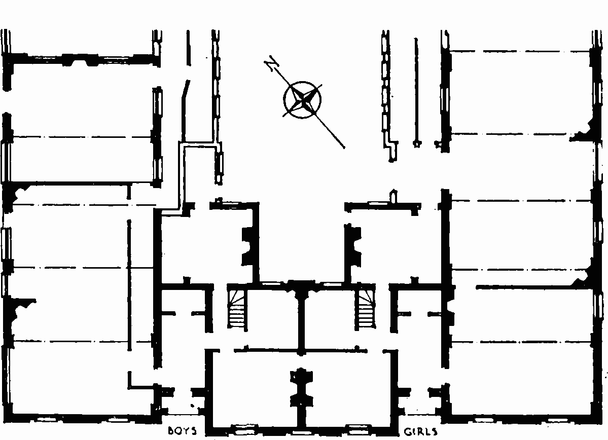
St. Mark’s Primary School, Harleyford Road, ground-floor plan. Later additions at the back not shown
The school is a modest little building in the Regency manner. The two-storeyed dwellinghouse, of three bays crowned with a simple cornice and pedimented blocking course, is flanked by single-storeyed pedimented classrooms, one for boys and the other for girls, extending back from the frontage. The ground floor of the centre block is arcaded and divided from the first floor by a stucco string-course which forms the sills of the square-headed first-floor windows. The classroom blocks are linked to the centre block by means of stucco recessed entrance porches. The pedimented blocking course bears the inscription “KENNINGTON SCHOOLS” and the date, 1824, is inscribed on the frieze below.
Nos. 155 and 157 Kennington Lane
Formerly Nos. 155 and 157 Lower Kennington Lane Fig. 3, plot 7
This pair of houses was probably built shortly after William Clayton obtained his building Act in 1776; both houses were certainly standing in 1780. It is not known who built them, but a sub-lease for adjacent property indicates that part, at least, of this area of the demesne was in lease to a Mr. Tegetmeyin, (fn. 54) or Tegetmeyer, (fn. 55) whose executors had the custody of the property in 1789. Tegetmeyer may therefore have been responsible for the erection of houses on this part of the demesne. James Bailey, who acted as local surveyor to the Duchy of Cornwall, lived at No. 155 for some years before 1792. (fn. 55)
These houses form a three-storey pair with simple fronts of plum brick, the windows having gauged flat arches of red brick. Their architectural interest centres in the two very fine wood doorcases (Plate 69a and 69c), which have similar key-ornamented architraves; though differing in detail the doorcases are complementary.
Nos. 137–145 (odd) Kennington Lane
Formerly Nos. 137–145 Lower Kennington Lane; Nos. 137–143 were originally Nos. 43–46 (consec.) Guildford Place
Fig. 3, plot 8
These houses formed part of a row built on this piece of the demesne about 1785–6. They are not listed in the text of Hodskinson and Middleton’s survey but are shown on the map of 1785; they first appear in the Land Tax records in 1787. (fn. 55)
No. 139, and the pair Nos. 141 and 143 which are set forward, are three-storey houses of plum brick with gauged flat arches of red brick to the windows. Each has an arched doorway emphasized with vermiculated blocks and a triple keystone. No. 137 was probably once of the same character, but has been unsympathetically refronted. No. 145, which is set forward from Nos. 141 and 143, is of the same height and has an original shallow-bowed shop-front with a dentil cornice over the fascia.
Vauxhall Baptist Church, Cottington Street
Fig. 3, plot 8
This building was erected in 1883, the foundation stone being laid by Alderman Sir William McArthur, K.C.M.G., M.P., on July 9. The architect was G. L. Wade and the builder B. E. Nightingale. The church is an uninteresting stock brick building with red brick dressings; three large round-headed windows overlook the street.
Nos. 86–92 (even) and 96 Kennington Park Road
Formerly Nos. 12–15 (consec.) and 17 Clayton Place
Fig. 3, plot 8
These houses were built between 1784 and 1787. They are not mentioned in Hodskinson and Middleton’s text but are shown on their accompanying map, and were probably in course of erection while the survey was being prepared. Part of Clayton Place appears in the Land Tax records in 1786 and all of it in 1787. (fn. 55) It is not known who was responsible for building the houses. Thomas Holloway had the lease of the site of St. James’ Chapel in 1796 (see below); he may have had the whole of the Kennington Park Road frontage of this section of the demesne on lease and undertaken its development.
Nos. 86 and 88 are a pair of tall plain terracehouses of four storeys with semi-basements. The fronts are ornamented by cast-iron balconies and window guards on the first floor and by neat round-headed entrances with vermiculated voussoirs. The entrances adjoin and each has a triple keystone, fluted and vermiculated. Each house has a square boundary pier of brick with a stone capping. There is an elliptical patera beneath the cornice on each face of the piers.
Nos. 90 and 92 are a pair of three-storey houses, their stock brick fronts being united by the imposts of the arched ground-floor windows and doorways, and by the continued sill-band below the first-floor windows. The fronts are finished with a cornice and blocking course. The doorway of No. 90 has a reeded surround, while that of No. 92 has fluted pilasters with key ornamentation beneath its hood.
No. 96 is of the same height and finished with a cornice. Its ground-floor windows are recessed in round arches linked by an impost band, and there are two-storey wings which are slightly set back from the two-window wide centre portion. The northerly wing contains a reeded round-headed doorway.
St. James’ Chapel, Kennington Park Road
Fig. 3, plot 8
A chapel appears to have been built on the vacant site between the present Nos. 78 and 80, Kennington Park Road about 1796. In September of that year Thomas Holloway granted a sub-lease of the site to the Rev. David Bradberry. (fn. 56) The building is shown on Horwood’s map of 1819 as the Kennington Meeting and Allen described it in 1826 as “a Chapel for the use of the Independents … plainly fitted up with galleries round three sides, and an organ; and … capable of accommodating about five hundred persons”. (fn. 57) Probably in the 1840s it was taken over for an Anglican proprietary chapel dedicated to St. James. The funds of the chapel subsequently declined and in 1863 were reported to be “in rather a drooping condition”. (fn. 58) The sublease was put up for sale in 1873 after an action for ejectment, and was purchased by the minister, the Rev. Samuel Bache Harris. The lease was surrendered and the site purchased in 1874, and after alterations to the building, the chapel had a district assigned to it from St. Mark’s in 1875. It remained a district chapelry until 1921 when it was united with St. Mary the Less; the site was sold to the Navy, Army and Air Force Institutes in 1923. The proceeds of the sale were given for the building of St. Anselm’s Church, Kennington Road, which also received some of the church furniture. (fn. 56) The building was pulled down and the site used for an office building with an entrance to the N.A.A.F.I. premises between Kennings Way and Cottington Street.
Salvation Army Barracks, Kennington Lane
Fig. 3, plot 9
The former Carlisle Chapel (Congregational), which is now occupied by the Salvation Army, has a poorly designed front of stucco, finished with a pediment. The ground storey contains a round-headed window flanked by doorways, and there are three round-headed windows on the upper floor.
The Church of England Children’s Society Headquarters, Kennington Road
Formerly the Vestry Hall
Fig. 3, plot 10
The history of the site on which the Church of England Children’s Society building stands is obscure. Harbord’s map of 1636 suggests that it was then part of a copyhold tenement which lay on the west side of the old track from Kennington Cross to the Common; this track followed the line of Windmill Row across the present Kennington Road, turned at right angles south-west-wards down Milverton Street and thence crossed Kennington Road again to the north-west side of Kennington Green (fig. 6). In 1615 the extent of this copyhold, held by Edward Carpenter, was estimated at approximately 14 acres; by 1785 it had come into the hands of Sir Joseph Mawbey. When Kennington Road was made from Westminster Bridge Road to Kennington Common, the old track shown on Harbord’s map appears to have been straightened, and comparison of Harbord’s map with that of Hodskinson and Middleton suggests that a triangular portion, the site of the Society’s building, had been detached from Mawbey’s copyhold by the straightening of the track. In 1785 the site is shown as a pond. However, the extent of Mawbey’s copyhold was estimated as 14ac. 3r. 16p. and the description indicates that the pond was not included in it. When development was contemplated, the site was considered to be roadside waste, and was treated as demesne land of Kennington Manor. Whether time and the uselessness of the site had obliterated the memory of copyhold tenure, or whether Harbord’s map is inaccurate, it is impossible to say.
This triangular site was one of the last parts of Kennington to be developed, probably because of its dampness. In 1851 it was reported that the surveyors of the parish highways “used it as a place of deposit for materials and for Road Scraping of which … there is a considerable accumulation now upon the Ground”; (fn. 59) this may have been the reason for the disappearance of the pond. In January 1851 the Rev. W. Leask of the Esher Street Congregation enquired whether a lease could be granted to him to use the land “as a site for a chapel in connection with the Congregational Body … our chapel … being too small”. (fn. 59) Nothing seems to have come of this proposal, and instead Mr. C. J. Beckham was accepted as tenant from Lady Day 1851 at a rent of £30 per annum, to carry on a business as a summer-house- and chair-maker. Beckham found that the surveyors of the highways were loath to give up the ground, and the matter was taken up with the Vestry Clerk by the Duchy of Cornwall. (fn. 59)
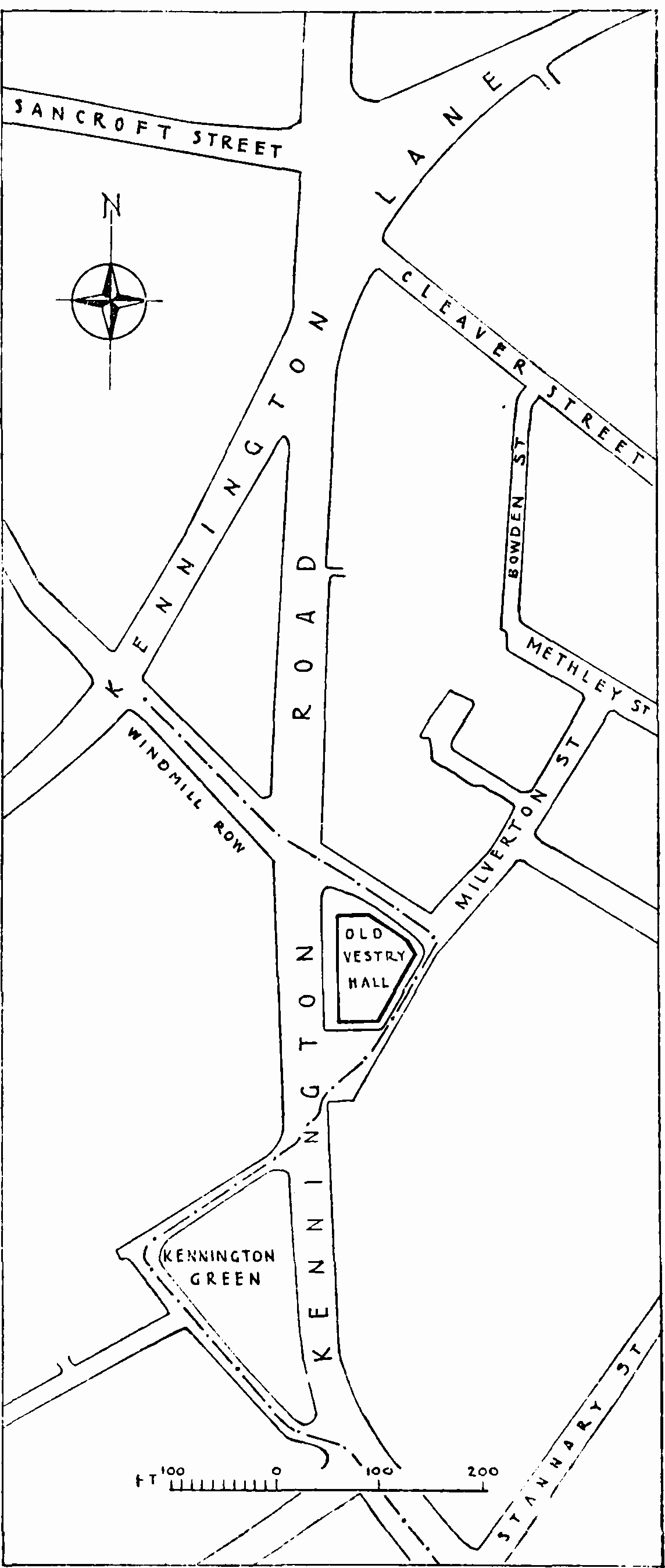
Kennington Road, lay-out plan. The broken line shows the course of the old road
In April 1849 the Lambeth Vestry had informed Members of Parliament for the neighbourhood that the old vestry hall in Church Street (built in 1809) was inadequate for the business of the parish, and that they wished a Bill to be promoted in Parliament to enable them to build a new hall. (fn. 60) The Vestries Act of 1850 (fn. 61) gave vestries power, with the assent of the Poor Law Commissioners, to erect suitable buildings for their meetings, and after a three-day poll of the ratepayers it was decided that the Act should be put in force in Lambeth. (fn. 62) The Vestry then enquired whether the Duchy would “let the Parish have the ground with power to enclose and plant or to erect a public building thereon”. (fn. 59) Negotiations for a lease were begun, but a number of vestrymen opposed the whole scheme on grounds of extravagance; when a vote was taken some of them declined “to come out of the room”, while others appear to have voted twice. (fn. 63) Eventually another poll lasting four days agreed to the proposal. (fn. 62) By a lease dated June 16, 1852, the Duchy of Cornwall demised the site to the churchwardens and overseers of the parish for 99 years at an annual rent of £10, on condition that the lessees should “before the eleventh day of June one thousand eight hundred and fifty four improve the said demised premises by the erection thereon at a Cost of not less than two thousand five hundred pounds … of a substantial one story building [i.e. ground floor and one storey over] to be used as a Vestry Hall for the Parish of Saint Mary Lambeth”. (fn. 64) Beckham was given notice to vacate the land, (fn. 59) and the Vestry borrowed £4,800 on the security of the Poor Rate for the new building. (fn. 65) The architects were Messrs. Willshire and Parris (fn. 66) and the work was carried out by William Higgs (fn. 67) (Plate 36a). The dampness of the area seems to have re-asserted itself, for the basement was flooded before the first meeting (fn. 68) on September 29, 1853. (fn. 62)
Within a few years the Vestry found the new hall too small for its purpose, and in 1856 applied to the Duchy of Cornwall for permission to add further accommodation. Permission was, however, refused because of the strict conditions laid down in the lease. The Vestry were not easily dissuaded, and in 1860 enquired whether they could purchase the reversionary interest. Although it was not the Duchy’s practice to sell demesne, it was prepared to consider a sale if a covenant could be inserted to prevent the building being raised above one storey, and so safeguard the value of the adjoining property. Plans were prepared for alterations, but the scheme lapsed. In 1881 and 1882 there were other applications to extend the accommodation, and in 1886 a request was made to purchase the freehold of the property; the price was estimated at £2,860. A dispute between the churchwardens and overseers of the parish, and the Vestry “as to the right of holding this property” arose, and the offer was eventually declined. Finally in 1892 more plans for extending the building to three storeys above ground level were prepared, but the Duchy still declined to relax the terms of the lease. (fn. 59)
With the setting up of Borough Councils in 1899 the 120 members of the Vestry were replaced by a Mayor, ten Aldermen and sixty Councillors. The new powers vested in the Borough Council made the problem of accommodation acute, and it became obvious that no amount of rebuilding would fit the Vestry Hall for the new functions of the Council. A new Town Hall was built at Brixton (see page 100), and the last meeting of the Council at Kennington was held on April 2, 1908. (fn. 69) The Borough Council suggested that the Duchy might purchase the remainder of the lease, but this offer was declined, and the lease was assigned to the Waifs and Strays for £2,600. (fn. 70)
The Church of England Children’s Society, known as the Waifs and Strays until 1946, had early connections with South Lambeth. Prebendary Edward Rudolf, Superintendent of the Sunday Schools at St. Anne’s, South Lambeth, and his brother Robert, were dismayed at the plight of poor children. At their instigation a meeting was held in 1881 at Mark Beaufoy’s house in South Lambeth Road to establish a society within the Church of England (fn. 71) “To rescue and care for children who are orphaned, homeless, cruelly treated or in moral danger, and to relieve over-burdened homes”. (fn. 72) The Archbishop of Canterbury consented to become President, and the first home was opened within the year at 8 Stamford Villas, East Dulwich. (fn. 71) The Society has had a considerable influence on modern legislation for the welfare of children. It still has its headquarters in the old Vestry Hall, to which it moved after alterations (fn. 59) in 1909.
The building has an asymmetrical plan due to the limitations of its triangular site. The exterior, Classical in design and rather pompous in expression, is of two storeys and is built of grey brick ornamented with stone and stucco. The Kennington Road front is dominated by the centrally placed portico, tetrastyle and of the Roman Doric order, set slightly forward from the general building face. The outer columns are paired with antae and the entablature is surmounted by a triangular pediment. The middle bay contains the main entrance, framed by a doorcase formed by rusticated pilasters and quoins and a pedimented entablature. Each flanking wing has three widely-spaced windows to the ground- and first-floors, the former being round-headed and the latter segmental-headed. All are recessed with marginal surrounds and the middle window on each floor is flanked by paired pilasters. The ground-floor arches have moulded imposts and archivolts, with keystones rising to the continued entablature below the first-floor windows. These latter have keystones rising to the crowning modillioned cornice, above which is a blocking-course parapet.