Survey of London: Volume 26, Lambeth: Southern Area. Originally published by London County Council, London, 1956.
This free content was digitised by double rekeying. All rights reserved.
'Brixton: Rush Common', in Survey of London: Volume 26, Lambeth: Southern Area, ed. F H W Sheppard (London, 1956), British History Online https://www.british-history.ac.uk/survey-london/vol26/pp131-136 [accessed 30 April 2025].
'Brixton: Rush Common', in Survey of London: Volume 26, Lambeth: Southern Area. Edited by F H W Sheppard (London, 1956), British History Online, accessed April 30, 2025, https://www.british-history.ac.uk/survey-london/vol26/pp131-136.
"Brixton: Rush Common". Survey of London: Volume 26, Lambeth: Southern Area. Ed. F H W Sheppard (London, 1956), British History Online. Web. 30 April 2025. https://www.british-history.ac.uk/survey-london/vol26/pp131-136.
In this section
RUSH COMMON
Rush Common (sometimes Rushey Common or Rushey Green) and Norwood Common were the two main areas of common land in the Manor of Lambeth. Most of Rush Common lay in the triangle formed by Brixton Hill, Effra Road and a line drawn in a south-westerly direction from the junction of Effra Road and Water Lane to Brixton Hill; there was also a long narrow spur extending up the east side of Brixton Hill, and shorter spurs along the northern end of Tulse Hill and the southern end of the east side of Brixton Road.
An Act of Parliament (fn. 190) of 1806 provided for the appointment of Commissioners who were empowered to divide and inclose the common lands of the Manor; the Act also forbad any building on certain parts of Rush Common (Plate 72a). In the 18th and early 19th centuries turnpike and other local Acts often proscribed building in parts of the areas to which they applied; in 1756, for instance, the Act authorizing the building of what are now Marylebone, Euston and Pentonville Roads forbad the erection of any buildings within 50 feet of either side of the road. (fn. 191) The proscriptions contained in the Lambeth Manor Inclosure Act were incorporated in the Inclosure Commissioner' Award of 1810, and the subsequent history of their enforcement has an important bearing on the development of the area.
The Act of 1806 stipulated that “no Buildings or Erections above the Surface of the Earth” (fn. 192) should be erected upon Rush Common within 150 feet of the London to Croydon Turnpike Road (now Brixton Road and Hill), nor within 200 feet of the old inclosures which formed the south and east boundaries of the Common, nor within 100 feet in front of any building already erected on adjoining land without the owner's consent. Persons injured by any infringement of these proscriptions were empowered to proceed against the offender. Section 33 of the Act provided, however, that encroachments which had been made at least twenty years before 1806 should not be considered as part of the Common; by implication they were therefore exempt from the clauses which forbad building in the areas described above.
By their Award of 1810 (fn. 193) the Commissioners divided and allotted the Common, and provided for the layout of the roads now known as Effra Road and St. Matthew's Road. By an amending Act passed in 1821 (fn. 194) these two roads were made parish highways, and the building proscriptions were modified to permit the erection of a church (St. Matthew's) with a burial ground and parsonage house only; the latter was in fact never built. The Award also provided for a projected canal from Croydon to Deptford to run across the Common; the canal was not made.
As long as the Act of 1806 remained within the memory of the inhabitants of the area the building proscriptions appear to have been observed; in 1859, for instance, a corn-chandler in Brixton Place (now Brixton Road between Coldharbour Lane and the high-level railway bridge) attempted to erect a building on his forecourt, but “the feeling of the neighbours was so strongly manifested and legal proceedings threatened that the intention was abandoned”. (fn. 195) Although the Metropolitan Board of Works had power to regulate building lines, it was not able to enforce the building proscriptions contained in the Act of 1806, and in 1875 one-storey shops were erected in defiance of the Board on the sites now known as Nos. 421–427 Brixton Road. In 1885, however, the continuation of this encroachment southwards was successfully prevented, probably through the legal action taken by an adjoining property owner. (fn. 196)
Between Josephine Avenue and Arodene Road the position was complicated by the existence of a house there before the Act of 1806. The house (which still stands at the back of No. 95 Brixton Hill, Plate 72b), must originally have been an encroachment on the Common, but if it were erected twenty years or more before the Inclosure Act, it and its curtilage were exempt from the proscriptive clauses. In 1880 the Metropolitan Board of Works granted permission for the erection of a one-storey shop upon the forecourt of No. 95, (fn. 197) and during the next five years seven other buildings whose fronts extended to the public way were erected; (fn. 195) their sites were presumably considered to be part of the exempted curtilage of No. 95. In 1899–1900, however, the London County Council received protests against the erection of three shops and houses (fn. 195) adjoining the south side of those erected between 1880 and 1885. In this case there appears to have been some doubt as to whether the site of these buildings formed part of the original curtilage of No. 95. Proceedings were taken against the builder of the three shops and houses, and the Council's Superintending Architect of Metropolitan Buildings defined the building line as being at a greater distance than 50 feet from the highway. The Tribunal of Appeal, however, decided that the building line was the back edge of the pavement of Brixton Hill. (fn. 198) A continuous line of buildings projecting up to the pavement still exists between Arodene Road and Josephine Avenue.
In 1891 the London County Council consented to the formation of Arodene Road and Helix Road provided that no buildings were erected “upon any of the ground forming a portion of Rush Common”. (fn. 199) Five years later the Council received several protests that houses were being erected in Arodene Road on proscribed land. But the Council was not a party injured by the encroachment and could not therefore take action under the terms of the Act of 1806. (fn. 195) The houses still stand.
During the early years of the 20th century acute difficulties over the enforcement of the provisions of the Act of 1806 frequently arose at the north end of the old Common, nearly all of which lay between the low-level railway bridge and Coldharbour Lane. Here the original houses had been built outside the proscribed area but gradually they had been turned into shops whose proprietors constantly erected stalls, kiosks and temporary structures on the forecourts. The London County Council (General Powers) Act of 1924 therefore contained a clause whereby the building line of Nos. 429–467 (odd) Brixton Road might be moved forward provided that all the owners agreed to surrender the part of their forecourts nearest to the road, which could then be widened. (fn. 200) The unanimous agreement of the frontagers was not obtained until 1935. In 1938 another Act (fn. 201) authorized the Council to permit building on part of the proscribed land occupied by Nos. 415–427 (odd) Brixton Road, subject to such conditions as might be agreed upon by the Council and the owners; these powers have not yet been applied. In 1939 (fn. 202) similar statutory powers were granted for the proscribed land between Coldharbour Lane and Rushcroft Road, where the Public Library had been erected in 1891–3 and a theatre in 1894–6, (fn. 102) both partly on proscribed land.
The total area proscribed from building by the Act of 1806 was about 34½ acres, of which only a very small proportion had been dealt with by these three Acts. In the remaining area south of the junction of Effra Road and Brixton Hill many difficulties arose over the interpretation of the Act of 1806. In Effra Road there appeared to be a contradiction between the wording of the Act and the Award of 1810; moreover the original plans of 1810 had probably shrunk or stretched, and the thickness of their lines represented four to eight feet. Problems such as these could only be solved by fresh legislation, and in 1947 the Council was empowered both to enforce the prohibition in the Act of 1806 and to consent to the erection or retention of buildings in the proscribed area, subject to agreement between the Council and the owners. (fn. 203) These powers will eventually result in the widening of Brixton Hill and Effra Road; most of the long and often neglected gardens (Plate 72c) which the Act of 1806 produced are designated as private open spaces in the County of London Development Plan of 1951. The proscribed area south of the junction of Brixton Hill and Upper Tulse Hill is in the Borough of Wandsworth, and blocks of flats set well back from the roadway have recently superseded the private houses; the land in front of these flats is designated as public open space. Thus in due course the whole area will once again acquire the spaciousness which was originally intended and which is so conspicuously absent in many parts of Lambeth.
St. Matthew's Church, Brixton
By their Award of 1810 the Lambeth Manor Inclosure Commissioners allotted three parcels at the northern end of Rush Common to the Archbishop of Canterbury, the Rector of Lambeth and Robert Stone. After the establishment of the Church Building Commissioners in 1818 the Lambeth Church Building Committee decided that these three plots would form a fine site for a church and burial ground. (fn. 204) The building restrictions contained in the Inclosure Act of 1806 had to be modified by an amending Act of 1821 to permit the erection of the church. (fn. 194) The land belonging to the Rector was then conveyed to the Commissioners gratuitously for the site of the church. (fn. 205) The Archbishop's land was made into a burial ground (fn. 206) and £88 was paid to Robert Stone's Trustees for their piece. (fn. 205)
The architect of the church was C. F. Porden. (fn. 205) The first stone was laid by the Archbishop of Canterbury on July 1, 1822, (fn. 207) but work on the foundations was started in the previous autumn by Mr. Mercer of Millbank. The soil proved looser than the architect expected, and extra foundations were needed. Mercer then became insolvent and his contract was completed by Messrs. Thomas Want and John Richardson. J. and H. Lee of Chiswell Street, who were well known “as builders of the greatest respectability”, (fn. 204) shared in the completion of the church, whose total cost was £16,150, of which the Church Building Commissioners contributed £7,917; the remainder was raised by the parish of Lambeth. (fn. 208) The church (Plates 5, , , , 11b, 12) was consecrated on June 21, 1824 by the Bishop of Winchester. (fn. 207) There were 904 rented sittings and 1,022 free seats. By an Order in Council gazetted on March 29, 1825, a District Parish was assigned. (fn. 205)
In 1829 the Gentleman's Magazine described St. Matthew's as “ one of the few chaste specimens of classical architecture to be found amongst the various new Churches in the environs of the Metropolis”. The writer went on, however, to deplore the use of the Grecian style for churches, and criticised the siting of the church, whereby “the portico is lost, in consequence of the sides being closed; until the spectator arrives opposite to the building, he can only imagine there may be a portico”. (fn. 207) Nevertheless, St. Matthew's is the finest early 19th century church in the area under review.
In plan St. Matthew's is a simple rectangle, with a portico fronting the vestibule and flanking staircase-lobbies at the west end, and a tower projecting centrally from the east. By so disposing his portico and steeple, Porden gave architectural interest to both the important road frontages. Furthermore, he forestalled the adverse criticism usually levelled against any attempt to combine these two essentially disparate elements.
The severe Doric exterior, impressive in scale, is built of grey brick dressed generally with Bath stone. Pedestals flank the wide steps that ascend to the portico, tetrastyle in antis, where Portland stone columns are combined with Bath stone antae, entablature and pediment. The entablature continues as a unifying motif right round the building. The rear wall of the portico is a plain brick face containing three doorways with tapered jambs and straight heads, the middle opening being slightly higher and wider than the others, which are not centred with the intercolumniations. Framed by an eared architrave of Bath stone, each door has two wooden leaves, with three tall panels within a running band of ivy-leaf ornament.
The portico, being in antis, is not expressed on the side elevations, hence the criticisms made in the Gentleman's Magazine. Here the only ornament is provided by the entablature, the narrow antae at each end, and the single tier of five equally spaced windows, which have architraves of similar form and detail to those of the portico doorways. Centred beneath the westernmost window on each side is a low pedimented porch, projecting and approached by steps descending to the crypt.
The east front is by far the most original feature of the whole design. The steeple, consisting of a square two-stage tower surmounted by an octagonal lantern, projects well forward from the flanking two-storeyed porches, framed by antae that support the continued entablature. The first stage of the tower, of equal height with the body of the church, rises from a steeply stepped podium of granite and contains in its east face a tall window. This has a tabernacle frame with its flattened pediment superimposed on the architrave of the main entablature which here is without triglyphs. The second stage, housing the belfry, is raised on a stepped plinth. Each face is identical in having a tall louvred opening recessed between Doric columns which are coupled with the antae at the angles. The plain entablature of this stage is surmounted by a pedestal parapet broken by a clock dial on each face. From a small square plinth rises the octagonal open lantern, a charming feature reminiscent of both the Lysicrates Monument and the Tower of the Winds. Its pyramidal roof has stone ornamental ribs that converge in an acanthus crown supporting the cross.
The middle doorway in the west portico opens to an aisled vestibule leading to the floor of the church. Each side doorway gives access to a lobby with an open staircase to the gallery. The very spacious and airy interior has a gallery on three sides, and a flat single-span ceiling. The minimum of ornament has been used to considerable effect, and architectural interest is rightly focused on the setting for the altar, where the plain wall faces of the gallery are terminated by pilasters, framing a recess containing a tall rectangular window flanked by Doric columns. A simple cornice adorns the gallery fronts and the supporting square piers have delicately moulded caps. Moulded ribs intersect to form a pattern of alternating wide and narrow panels on the ceiling.
Most of the box pews survive, together with some of the original furnishings. The simple Doric organ-case in the western gallery, and the communion rail of iron, with tall Doric column balusters and an open frieze of laurel-wreaths, are well worthy of notice. A series of chaste Grecian memorial tablets, in white and grey marble, relieves the severity of the plain wall surfaces.
At the north end of the churchyard, which has recently been converted into a public open space, is a remarkable monument (Plate 71a) erected by Henry Budd in memory of his father Richard Budd (1748–1824). It was designed and executed by R. Day in 1825, and was described by Thomas Allen, the historian of Lambeth, as “without doubt the finest sepulchral monument in the open air in the metropolis, and perhaps not equalled by any one in the kingdom”. (fn. 209) It is of Greek derivation in its parts, with some Egyptian features, and shows the influence of Soane. Square in plan, it is built apparently of Portland stone, in three main stages, on a stepped granite base. The four faces are identical except for a low sunk doorway with a projecting pedimented lintel, which cuts into the base on the west side. The lowest step has vermiculated rustication on its face. The main stage consists of four broad pedimented stele projecting from the central block, with classical urns set in the reentrant angles thus formed. The stele are ornamented with paterae and egg and dart moulding, and contain white marble slabs carrying inscriptions to members of the Budd family. The pediments are surmounted by acroteria at the corners. The second stage has a cornice of considerable projection with scrolled acroteria, the square panels below containing openings with fretted iron grilles and carvings of the serpent with its tail in its mouth, symbol of eternity, and the winged globe, the Egyptian hieroglyph for the Almighty Creator. Flanking these panels are low relief carvings of angels in side panels which are returned on to the adjoining face. The top stage is stepped back and has carvings of the Holy Dove in its four panels. The acanthus-leaved cornice supports segmental pediments topped by two blocking courses and a large anthemion finial.
Nos. 1–21 (odd) St. Matthew's Road
Formerly Nos. I–II (consec.) Church Road
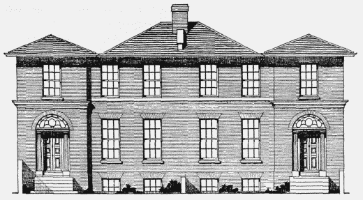
In 1825 Robert Stone's Trustees agreed to lease a plot of land between Effra Road and St. Matthew's Road to William Brass of Wood Street, Cheapside, builder. (fn. 210) This land was formerly part of Rush Common, and the building restrictions contained in the Act of 1806 forbad the erection of houses on much of it; the most northerly house was given a disproportionately large garden in consequence (fig. 40). Nos. 1–5 were built by Brass between 1825 and 1827.
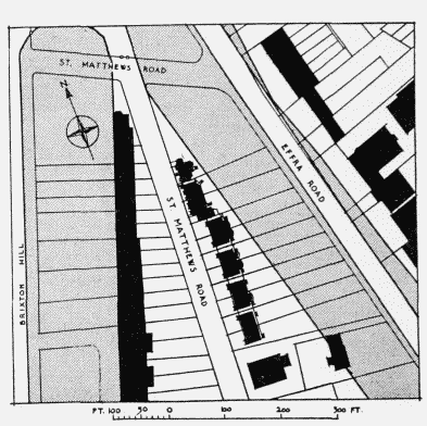
St. Matthew's Road, lay-out plan. Shading denotes the area proscribed from building by the Act of 1806
No. 1, a stucco-covered villa of two storeys and a semi-basement, has a central entrance which is attended by Greek Doric columns. The columns, which have poorly detailed abaci, support a moulded transom and have a plainly patterned fanlight above. The doorway sets forward slightly and is finished with a dentilled cornice and blocking course, the latter continuing as a sill-band linking the first-floor windows. There is a semicircular ground-floor bay projection on the north side finished with a dentilled cornice, like that over the entrance, and a balustraded parapet.
Nos. 3 and 5 (fig. 41) form a pair of stock brick houses of the same height as No. 1, and have similar entrances. These are set in two-storey wings which project forward slightly and are divided by cornices at first-floor level. Like No. 1, their upper windows are underlined by a continuous sill-band. This pair has a slated roof of less steep pitch. No. 5 is the vicarage of St. Matthew's Church. The curious plan of No. 3 (fig. 42) was probably adopted to prevent any encroachment on the area proscribed from building.
Nos. 3 and 5 St. Matthew's Road, 1825–7. Lessee, William Brass, builder
William Brass subsequently got into financial difficulties, and Nos. 7–21 were erected shortly after 1840 by William Lawrence of Hoxton, builder. All these houses have recently been demolished. They formed four pairs of severely detailed stucco-fronted houses of three storeys with semi-basements, and almost hidden roof attics. Each house had a wing, slightly set back, of full height, containing a recessed porch guarded by a pair of Greek Doric columns. The fronts were finished with a cornice and blocking course, the latter inflected to form an unmoulded pediment over each pair. The porches were flanked by flat piers and the houses were given an appearance of added strength by the channelling of their ground storeys and by the joining of their upper-floor windows with deep sill-bands. The pairs were linked by simply pilastered screen walls containing entrances to the back gardens.
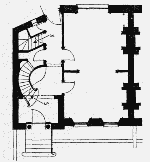
No. 3 St. Matthew's Road, ground-floor plan
Trinity Congregational Church, St. Matthew's Road
The foundation stone of this church was laid on September 23, 1828. The church (Plate 71a, fig. 43) is almost square in plan, austere in character, and built of yellow stock brick. The two-storeyed front is divided into three bays, the centre being slightly recessed. Each outer bay contains a ground and semi-circular headed first-floor window, both framed in a shallow arched recess. From the central bay projects the one-storey Greek Doric porch. The crowning entablature is surmounted by a blocking course inflected to form a low pediment over the central bay. A U-shaped gallery extends round three sides of the nave and is supported by Greek Doric columns; the windows are segmental below and round-headed above the gallery.
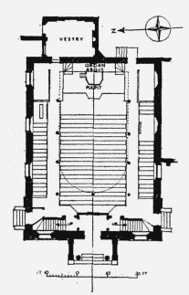
Trinity Congregational Church, St. Matthew's Road, plan
St. Matthew's C.E. School, St. Matthew's Road
This school was founded in 1828. (fn. 211) By 1870 the building had become very dilapidated, (fn. 211) and it was entirely rebuilt in the following year, (fn. 212) Joseph Gale being the architect. (fn. 213) This new building, which accommodated 600 children, was heavily damaged during the war of 1939–45, and is not now used as a school. It is a two-storey brick building dominated by a tapering rectangular tower at the north-east corner. The tower has a chisel roof crested with ornamental ironwork.
Nos. 4–12 (even) and 18 Effra Road
In the 1820s a number of detached houses of various sizes were built along the west side of Effra Road; all of them were set well back in order to comply with the building restriction contained in the Inclosure Act. Only four of these houses survive. Nos. 6 and 8 are two-storey stock brick cottages with central doorways and one window on each side. No. 6 has round heads to the ground-floor windows and entrance, with an impost band and sill-band above. No.8, which is illustrated in a supplement to The Architect and Building News of October 7, 1932, is faced with stucco and has a trellised porch.
Nos. 10 and 12 are stuccoed, two-storey villas, three windows wide, No. 10 being raised on a semi-basement and having an extra storey in a mansard roof at the rear. Its central doorway has a long narrow fanlight and is flanked by attenuated Greek Doric columns. There are iron guards to the ground-floor windows and those above are square with a sill-band. No. 12 has traces of a portico but both houses are now in ruins. Nos. 4 and 18 Effra Road, both now demolished, are illustrated in supplements to The Architect and Building News of May 6 and September 2, 1932, respectively.
Tate Central Free Library, Brixton
This building and its site were presented to the Lambeth Public Libraries Commissioners by (Sir) Henry Tate, and cost about £15,000. The library was opened by the Prince of Wales on March 4, 1893; the architect was Sidney R.J. Smith, (fn. 214) and the builders were F. and H.F. Higgs. (fn. 215) A brass tablet in the entrance hall records that the garden in front of the library was given in 1905 by Amy, Lady Tate in fulfilment of a wish of her husband Sir Henry Tate, bart.
The library is a boldly conceived building of two storeys in Classical style, built in Elham Valley red brick with Portland and Beer stone dressings. The central entrance and the end pavilions are slightly set forward and the ground storey brickwork is rusticated. The entrance has a coffered round arch and there are freely carved panels at either side. The balcony above is borne on pairs of consoles. The centre and end pavilions are pedimented, the former being elevated on coupled pilasters. The roof is of slate with a central wood lantern.