Survey of London: Volume 26, Lambeth: Southern Area. Originally published by London County Council, London, 1956.
This free content was digitised by double rekeying. All rights reserved.
'Brixton: The manor of Heathrow, Milkwood and Wickwood', in Survey of London: Volume 26, Lambeth: Southern Area, (London, 1956) pp. 136-139. British History Online https://www.british-history.ac.uk/survey-london/vol26/pp136-139 [accessed 26 April 2024]
In this section
THE MANOR OF HEATHROW
The small Manor of Heathrow or Knight's was held as freehold of the Manor of Lambeth, to which a quit-rent of 12d. a year was paid. (fn. 216) The name “Knight's” suggests that the area was formerly occupied by the Knight family, who held much land in Lambeth in the sixteenth century. The Manor passed into the possession of Thomas Wiseman and after his death to his son Thomas. (fn. 217) The latter was a Jesuit priest in Rome and by 1594 he had sold the Manor to William Wiseman who in his turn had sold it to Francis Fitch. (fn. 218) It was subsequently acquired by Sir Francis Goston (fn. 216) in whose family's ownership it remained until 1658 when Francis Gofton conveyed it to John Scaldwell. (fn. 219) By his will, which was proved in 1679, Scaldwell left the Manor and three adjoining acres of copyhold of Lambeth Manor to his wife Dorothy for life and then to his grandson Thomas Fox. (fn. 148) No later reference to this Manor has been discovered, but by tracing the descent of the adjoining copyhold in the Court Books the position of Heathrow has been identified. (fn. 220) It comprised some 70 acres south of Coldharbour Lane on the east side of Effra Road and the north-east side of Dulwich Road. The parcel of land now covered by Geneva and somerleyton Roads may also have been part of Heathrow Manor; on the Lambeth Manor Inclosure map of 1810 it is shown as freehold land belonging to W. Angell. Between 1791 and 1806 Robert Stone bought Heathrow in four parts; it was then known as Effra Farm. (fn. 221) The value of the land was greatly enhanced by the layout of Effra Road in 1810 by the Lambeth Inclosure Commissioners, and again a few years later by the building of St. Matthew's Church. Stone divided the northern part of the area into plots and granted long leases. A few detached houses (none of which now survives) were then built. Robert Stone died in 1820, leaving a widow and seven children, all minors. His estate was so heavily burdened with debts that his executors refused to act, and his affairs were finally settled under Chancery supervision by a private Act of Parliament. (fn. 222) Some 33 acres were sold by auction in 1824. The rest of the property was afterwards let on building leases and sold at another auction in 1826. (fn. 223) The southern portion of the estate was bought by the Westminster Freehold Land Society in 1855, (fn. 224) and what are now Effra Parade, Chaucer Road, Spenser Road, Shakespeare Road and Milton Road were laid out on a much humbler scale than the northern portion of the estate.
Brixton Unitarian Christian Church, Effra Road
In 1840 the congregation of Brixton Unitarian Chapel obtained a long lease of a site on the east side of Effra Road; (fn. 225) the chapel which was subsequently built there was destroyed by enemy acton in 1940, and was replaced by the present temporary building.
Brixton Synagogue, Effra Road
The foundation stone of this synagogue was laid by Sir Robert Waley Cohen on May 1, 1921; Cecil Masey was the architect and W. J. Mitchell and son were the builders. (fn. 145) The walls of the building are rendered and painted white, and there is a Tuscan-typed columned porch extending across the front which is flanked by pedimented pavilions. There is a gallery round three sides of the interior.
St. Jude's C.E. Primary School, Railton Road
An inscription on the original building of this school stated that “This Building dedicated by Mr. and Mrs. Simpson and other contributors to the Christian Education of the Infant Poor was erected A. D. MDCCCXXXIV”. (fn. c1) The school was originally known as St. Paul's Infant School, but on the formation in 1869 of the ecclesiastical district of St. Jude's, the management of the school was transferred from St. Paul's, Herne Hill, in the parish of Camberwell, to a committee of the vicar and parishioners of St. Jude's. (fn. 226) The original building (Plate 35a), which is now dwarfed by later additions, is a single-storey stock brick structure with a slate roof; the wall facing Railton Road is pierced by five groups of three lancet lights.
Railton Methodist Church, Railton Road
This church was erected in 1874, R. Cable, being the architect and Richardson Bros, the builders. (fn. 145) Three years later schools were built at the rear, the architects being R. and J. Cable, and A. Peacock the builder. The church (Plate 27c) is built of stock brick with a steeply pitched slate roof. The front, which is faced with coursed Kentish ragstone, contains a centrally placed Decorated Gothic window above the dual entrance, and two narrow flanking windows above the secondary doorways.
MILKWOOD AND WICKWOOD
This portion of Lambeth Manor comprised some 86 acres on either side of Coldharbour Lane; one piece lay between the Lane and the east side of Loughborough Junction, and the other piece was bounded approximately by Poplar Walk, Lowden Road and Milkwood Road. Until the middle of the 17th century the whole area was woodland reserved to the Archbishop of Canterbury, but the trees were uprooted during the Common wealth (fn. 227) and after the Restoration the land was leased for successive terms of 21 years. (fn. 228) In 1711 a lease was granted to William East of the Middle Temple, (fn. 229) whose descendants continued as tenants until 1837, (fn. 230) when the lease was surrendered to Rice Richard Clayton. When it expired in 1865 the whole neighbourhood was being transformed by the construction of railways.
The development which took place shortly afterwards was architecturally undistinguished, but is of interest through its connection with the Suburban Village and General Dwellings Company. The purpose of this Company was “to provide at the most rapid rate possible, healthy, pleasant, and comfortable abodes, for the over-crowded population of the metropolis. The company will purchase estates in all the suburbs near to and having direct railway connexion with London, and erect thereon complete villages. The houses erected will contain from four to eight rooms with every domestic convenience, each house to have a piece of garden ground. Educational establishments, etc., will be provided, as also a limited number of shops. …” (fn. 231) Money was subscribed by 250 working men in hopes of obtaining houses, and Edward Vigers, Chairman of the directors of the Company, applied to the Ecclesiastical Commissioners for a lease of part of Milkwood and Wickwood. Meanwhile the Secretary of the Company had spent nearly all the available funds and the shareholders refused to pay the calls for extra money needed to implement the scheme. The directors were all deposed and an attempt was made to wind up the Company. (fn. 232)
At this unpromising moment W. G. Habershon, partner in the well-known firm of architects, Habershon and Pite, of Bloomsbury Square, offered to take over the estate for its original purpose. In 1868 he and his partner, A. R. Pite, reached an agreement with the Ecclesiastical Commissioners. They were to receive a 99 year lease of 24 acres, and covenanted to build roads and sewers and between 480 and 650 houses; as soon as any houses were completed, separate leases were to be granted to them or their nominees. (fn. 233) The first stone of the new village was laid on March 30, 1869, by Lord Shaftesbury. (fn. 234) bury. (fn. 234) The two main streets were Milkwood Road and Lowden Road, and the houses were to be “very pretty specimens of cottage dwellings in ornamental brick, and built in six, eight or ten rooms, exactly as the shareholder and intending occupier may wish”. (fn. 234) (Plate 73d, fig. 44). Houses could be purchased by a lump sum payment, or by instalments spread over 21 years.
By 1872 the project was well under way. The cheapest houses cost £200, but many were more expensive. Five houses built in Lowden Road in 1872 cost £1,739, while four shops elsewhere on the estate cost £2,559. (fn. 235) Builders were attracted by the proximity of the estate to the new railway lines, and by promises of advances of up to 60 per cent on the cost of every house covered in, (fn. 236) while purchasers were attracted by the cheap workmen's fares which the London, Chatham and Dover Railway Company was compelled to provide. Within four years of the signature of the agreement with the Ecclesiastical Commissioners, The Builder reported that the estate provided “a striking instance of the new suburban neighbourhoods rising up in succession in different places around the metropolis. About the present time last year the greatest portion of the land forming the estate was occupied as market gardens, but the entire area has now been laid out in wide and spacious streets, all drained and paved, and provided with ample footpaths, and upwards of two hundred privated houses and shops have already been erected and occupied, whilst a large number of new dwellings are at present in course of erection.” (fn. 237)
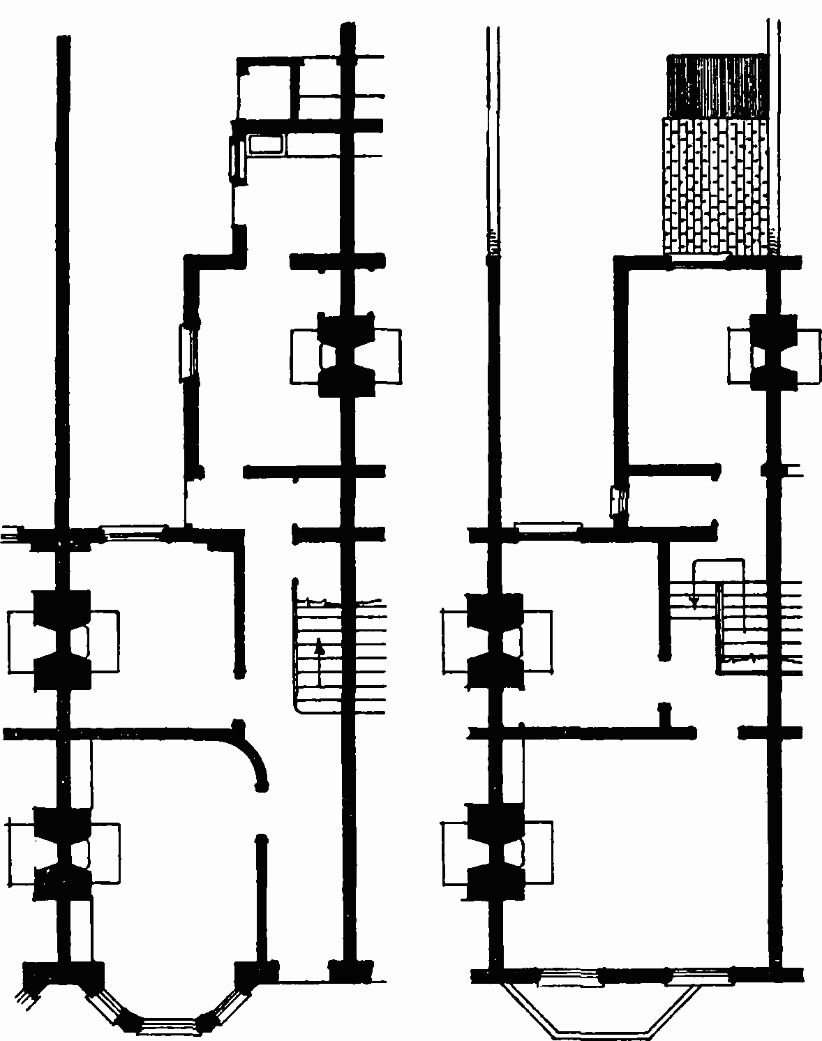
Houses in Milkwood Road, plans
The houses on the estate are built in terraces of stock brick with red brick dressings and slated roofs. Most of them are two-storeyed, a few three, and some of each type are raised on semi basements. The majority are two windows wide, with an arched doorway and bay window on the ground floor, and generally stone is used for lintels, arches and mullions, often with incised designs. Some mullions have cast-iron columns with enriched caps and a few houses have gables. Later development up the hill is distinguished by more gables, more red brick, square two-storey bay windows and ornamental terracotta.