Survey of London: Volume 27, Spitalfields and Mile End New Town. Originally published by London County Council, London, 1957.
This free content was digitised by double rekeying. All rights reserved.
'Mile End New Town', in Survey of London: Volume 27, Spitalfields and Mile End New Town, (London, 1957) pp. 265-288. British History Online https://www.british-history.ac.uk/survey-london/vol27/pp265-288 [accessed 25 April 2024]
In this section
CHAPTER XX - Mile End New Town
Mile End New Town was constituted a separate hamlet of the parish of St. Dunstan, Stepney, by an agreement of 22 July 1690 between its inhabitants and those of Mile End Old Town. This agreement was confirmed by a Chancery decree of 15 August in the same year, which stated that the population of the New Town was growing rapidly, and that it was principally composed of ’handicraft tradesmen’, many of whom were presumably weavers. By the terms of the separation the new hamlet was to choose its own officers, provide for its poor, and administer its own parish business. (fn. 1)
In 1711 it was intended that Mile End New Town should form part of a new parish of Bethnal Green, (fn. 2) but the hamlet remained in the parish of St. Dunstan, Stepney, until it was created a district chapelry of St. Dunstan's in 1841, (fn. 3) with its own church, All Saints’, Mile End New Town. In 1875 the southern portion of the parish was assigned as a district chapelry to St. Olave's. (fn. 4) When St. Olave's was closed in 1914, All Saints’ parish again included the whole area of Mile End New Town. In the reorganization of the parishes of Stepney which took place in 1951 the parish of All Saints was united to that of Christ Church, Spitalfields.
The area of the future hamlet appears to have been sold by the Lord of Stepney Manor in the mid-seventeenth century, like the southernmost part of Spitalfields hamlet. At this time it was probably entirely unbuilt, and used for digging brick earth.
Little is known about the earliest development of the district. It seems likely, however, that it began along the High Street (now part of Greatorex Street) and ’the Church Way’ (now part of Hanbury Street). The former was clearly an early means of access from Whitechapel, while the latter ran eastward from Spitalfields towards Mile End. (fn. 5) By the late seventeenth century the site of the new hamlet was divided from east to west by the Common Sewer, a drainage ditch which had apparently been created from an earlier natural watercourse, and which later formed the boundary between the two estates into which Mile End New Town was divided. As late as 1838 the Common Sewer was still an open ditch. (fn. 6)
Building development seems to have begun shortly after 1680, in isolated pockets along High Street and Church Street, and more densely on the land immediately to the east of Brick Lane. New streets were laid out at this early stage, but building was slow and spasmodic, and was apparently carried out to a large extent by jobbing builders with limited resources. They relied heavily on mortgages to raise the necessary capital, and were often unable to complete more than a few houses. The fines imposed by the Tylers’ and Bricklayers’ Company suggest that some of the work at least was of very poor standard. Thomas Slaymaker (presumably Thomas Slemaker or Sleymaker, see page 156) was fined in 1675 for making bad joints and using black mortar, in 1682 for defective tiles, and in March 1683 (?/4) for defective bricks. Mr. Bell, carpenter (presumably Nicholas Bell, see page 278), and Mr. Nicholls, bricklayer, were fined in March 1683 (?/4) for using very bad mortar in eight houses built by them. Mr. Drew (presumably James Drew, see page 278) was fined in 1685 for ’bad bricks, bad morter, bad worke and 7 howses not joynted’, while in January 1682 (?/3) a Mr. Holies was punished for using defective bricks. (fn. 7)
The haphazard method of building development which characterized Mile End New Town left pockets of open land in various parts of the hamlet. The last of these was not built over until the middle of the nineteenth century. In the meantime there must have been a steady process of rebuilding, so that today few houses earlier than c. 1800 survive. This rebuilding sometimes meant no improvement in the standard of housing in the area. In 1804 two houses collapsed in Dunk Street; they had been built of old materials about thirty-eight years previously and sheltered eight families, consisting of thirty-six persons. (fn. 8)
Deeds show that the usual, rather narrow, frontage of a plot was fifteen feet. Although no very early building now exists, rebuilding seems to have been carried out on a similar scale, so that some surviving terraces of the first half of the nineteenth century may be very similar in type to the original houses. The elevation and plan of what was probably a typical mid-nineteenth-century terrace-house is preserved in a deed of 1851 (fn. 9) It was completely plain, one window wide, and three storeys in height.
Nos. 31–51 (odd) Princelet Street (Plate 77c), although just outside the limits of Mile End New Town, are a typical example of the kind of rebuilding carried out there in the late nineteenth century.
Industrial and commercial premises first appear in Mile End New Town in the second half of the eighteenth century. They were concentrated at first in two places, the south side of Booth Street (now Princelet Street, east of Brick Lane) and Coverley's Fields, a large undeveloped area in the eastern portion of the hamlet. Later Coverley's Fields were given over completely to industrial premises, which now occupy many other sites throughout the area.
In 1846 the second model housing estate of the Metropolitan Association for Improving the Dwellings of the Industrious Classes was built in Mile End New Town. The completed project, a block of family flats, a lodging house for single men, and four terraces of cottages, deserves particular attention as an early forerunner of many modern blocks of municipal and Council flats.
Much of Mile End New Town is once again in process of rebuilding. The London County Council opened the first unit of its Chicksand estate in Hanbury Street in 1937. Other blocks have followed, and more are planned. To the north, the Stepney Borough Council is completing the first two units of another estate. The district suffered heavily from enemy action during the war of 1939–45 and there are many derelict and devastated areas interspersed among the surviving nineteenth-century houses.
The Tylney Estate and Haresmarsh
The northern portion of Mile End New Town was part of a large field known as the Haresmarsh, which extended north into the parish of Bethnal Green. In 1719 twenty-four acres, which included all the land under discussion, together with a smaller area east of the south end of what is now Vallance Road, was sold by William Cox, of London, gentleman, to Frederick Tylney of Rotherwick, Hampshire. (fn. 10) The earlier history of this estate is not known, but in 1717 Cox had stated that he and Sir John Davis ’were seized of diverse Lands in the Hamlet of Mile-End new Towne and that their Ancestors had made a boundary Ditch to fence and dreyne their Lands from Littlefield Streete to Mr. Guns Garden Gate’. (fn. 11)
This ditch became the Common Sewer which marked the southern limit of the land purchased by Frederick Tylney from Cox. The property subsequently passed by way of Tylney's daughter to his niece, Dorothy Glynne, who in 1703 married Richard Child of Wanstead, Essex. In the following year Child succeeded his father in the family baronetcy; he was created Viscount Castlemaine in 1718, Earl Tylney of Castlemaine in 1731 and in 1739 he and his sons adopted the name of Tylney. After his death in March 1749/50 the estate passed to his son John, Earl Tylney, who died unmarried in 1784, (fn. 12) leaving his property to his nephew, Sir James Tylney-Long. Provision was made in Earl Tylney's will (fn. 13) for the sale of part of the estate to meet legacies, but the Mile End New Town property was not affected until after the death of Sir James Tylney-Long in 1794. The Tylney estate was then found to be heavily indebted, and in compliance with a Chancery decree of 30 June 1802 the Mile End New Town estates were put up for sale on 18 and 19 August 1807. The property was offered in twenty-six lots at the public sale-rooms of the Court of Chancery. (fn. 14) The estate was thus broken up and divided into numerous small properties.
The development of the Mile End New Town portion of Haresmarsh had begun in the 1680's with the laying-out of Spital Street and the western end of Spicer Street (now part of Buxton Street). (fn. 15) Much of the area seems to have been held on lease by Richard Spicer, a haberdasher of London, who was responsible for some building in Spicer Street. (fn. 16) One house, No. 27 Spital Street, perhaps of this period, still survived in 1930 (fn. 17) (fig. 72). Spicer also assigned sub-leases of other parts of the new streets, including one to Samuel Norris of Shoreditch, gentleman. (fn. 18) Norris in turn sub-leased to Austin Reynolds, a joiner of London. (fn. 19) After Spicer's death his property was administered by trustees, including his widow and his son Richard, who was a carpenter. (fn. 20)
Hunt Street, now Hunton Street, appears to have been projected in about 1700, but only a few houses can have been built at this time. Two of them may have been built by Richard Slocock, (fn. 21) carpenter, of Stepney. (fn. 22) In 1719, when the estate was purchased by Frederick Tylney, there were forty-five houses in Spicer Street, thirty in Spital Street and five or six in Hunt Street, north of the Common Sewer, as well as eleven in Baker's Row (now the southern end of Vallance Road), five in Thomas Street (now the east-west arm of Fulbourne Street) and eight in White's Row (now the west end of Durward Street). There were also five houses in an unidentified street called ’Havies New Buildings or the back Lane’. (fn. 10) A small part of this area lies outside Mile End New Town.
More intensive building development began in Hunt Street in 1722. At about the same time Hunt Court (now Hunton Court) was laid out. Houses on the east side of Hunt Street north of Hunt Court and some houses on both sides of that Court were built by John Toe, carpenter, of Stepney. (fn. 23) At the same time a smaller site north of Toe's was leased by Spicer's trustees to Charles Gardiner, carpenter, of Stepney. (fn. 24) Most of the west side of Hunt Street was leased in 1724 to William Midford. He was not a builder himself, and it is possible that the building development specified in the lease was to be carried out by two of the witnesses to the document, William Dunn, bricklayer of Southwark, and Henry Peach, carpenter of Shoreditch. (fn. 25)
Two further portions of Haresmarsh were apparently not part of the Tylney estate, and lay outside Mile End New Town and the Borough of Stepney. Carter's Rents (later Carter Street, now Saul Street) and George Street (fn. n1) were laid out on a small piece of land bounded by Brick Lane, Spicer Street, the Common Sewer and the back of the property on the west side of Spital Street. This area was apparently first built up in c. 1670 by John Carter, (fn. 26) citizen and grocer of London (fn. 27) (see page 123). In 1677 he leased a site on the west side of George Street to John Welsh of Shoreditch, brick layer. (fn. 27) Both Carter's Rents and George Street appear to have already been built up by 1703. (fn. 28) In 1740 Elizabeth Carter of Hackney, spinster, sold the greater part of the land to Joseph Cooper of Tottenham High Cross, gentleman. (fn. 29) In 1740 Cooper granted building leases for the land on both sides of Carter's Rents to Emanuel Collett, carpenter, (fn. 30) and John Wolveridge, plas terer, both of Bethnal Green. (fn. 31) This suggests that some rebuilding was planned and perhaps carried out at that time. A dyehouse, formerly a brewhouse, which had occupied a site on the south side of Carter's Rents and was already in existence in 1709, (fn. 32) was not included in this grant. (fn. 31)
The southern side of Weaver Street now lies within Mile End New Town, but until the alteration of the boundaries in 1900 both sides of the street were in the parish of Bethnal Green; it was never part of the Tylney estate. By 1719 there were four houses in the street, probably the work of John Read, carpenter, of Stepney. (fn. 33) In 1721 three houses were in course of erection on the north side of the street by Vincent Harlock, victualler, of Stepney. (fn. 34) By 1746 building on the north side extended as far east as Fleet Street Hill but on the south side there was a single isolated structure. Apart from the addition of four houses on the south side, Horwood's map of 1799 shows little change.
Building development seems to have come to a standstill on the Tylney estate by 1740, and during the latter half of the eighteenth century the eastern half of the property remained open fields, as shown on Rocque's and later on Horwood's maps.
The sale and subsequent break-up of the Tylney estate in 1807 did not provide an immediate impetus towards building development. Horwood's map of 1819 still shows half the area as open fields, but Greenwood's map of 1824–6 shows that on the eastern side of this open area Luke Street (now the eastern end of Buxton Street), Buttress Street (destroyed during the war of 1939–45) and Underwood Street (now Underwood Road from No. 41 to Vallance Road) had been built, opening off the west side of Vallance Road.
An open area of approximately four and a half acres, comprising lot seven in the sale of 1807, was still left undeveloped. In 1809 the freehold was transferred from the Tylney estate to Thomas Colling of Old Street Road, St. Luke's, timber merchant. The tenant at this time was Timothy Runacles, who used the land as ’Gardners Ground’. (fn. 35) After passing through several hands the property came in 1846 into the possession of John Cookson of Kennington, gentleman, (fn. 36) who began to develop the area. Underwood Street (now Road) was extended westward to Charlotte Place, which was intended to connect Woodseer Street and Buxton Street. At the same time the latter was formed to connect Spicer Street and Luke Street; the whole street between Brick Lane and Vallance Road is now called Buxton Street. Albert Street (now Deal Street north of Woodseer Street) was laid out running north and south, with North Place at right angles at the northern extremity of the area. It appears that in 1846 Cookson made an agreement with the Eastern Counties Railway Company to extend Albert Street as far as the Company's goods warehouse immediately to the north of the hamlet boundary. (fn. 37) This scheme was never carried through. By 1848 Cookson had twenty houses completed, some of them by a Spicer Street builder named Simson. (fn. 38) In this and the following year Cookson's mortgagees agreed, as soon as building operations were completed, to lease the entire site north of the present Underwood Road to John Henry Dew and William Blenkarn, builders, (fn. 36) who were already active in the building up of Buxton Street. (fn. 38) By 1850 the south side of Buxton Street must have been complete, together with more than half of North Place. (fn. 39) All of this work was presumably done by Dew and Blenkarn. In 1849 the partnership was dissolved; Dew bought out Blenkarn's share in the enterprise and continued alone. (fn. 36) North Place was completed shortly after 1852 (fn. 40) and the north side of Underwood Street (now Nos. 1–39 (odd) Underwood Road) between 1850 and 1855. (fn. 39)
The area south of what is now Underwood Road was sold by Cookson and his mortgagees in two lots. That on the east side of Deal Street was purchased in 1848 by the Metropolitan Association for Improving the Dwellings of the Industrious Classes, and subsequently used as a site for model dwellings. (fn. 41) Most of the plot to the west of Deal Street was acquired in 1850 and 1851 by the Marist Fathers for their new church and presbytery. The site of the presbytery was purchased first, in 1850. The adjoining plot on the west side, which later became part of the site of the church, was presumably being reserved for a southward extension of Charlotte Place, as the western extremity of Underwood Road was then called; this plot was purchased by the Marist Fathers in 1851 when the proposed extension was abandoned. (fn. 9) The rest of the land on the west side of Deal Street was bought in 1850 by the King Edward Ragged Mission. (fn. 42) The development of this last area of open ground between 1846 and 1857 completed the building up of the former Tylney estate.
Mile End New Town Workhouse
Demolished
An Act of 1780 (fn. 43) for the relief of the poor and for paving, lighting and watching the streets of Mile End New Town appointed trustees (who included the churchwardens and overseers) and authorized them to establish a workhouse. In 1783 the trustees took a lease of two houses on the north side of Spicer (now part of Buxton) Street; (fn. 44) Horwood's map of 1799 shows two houses thrown into one, slightly to the east of Hunt (now Hunton) Street; one room served as a meeting-place for the Vestry, and when the workhouse was replaced by All Saints' Church, the Vestrymen retained their right to meet in a room of the church. The workhouse still existed in 1829 (fn. 45) but it was closed after the passing of the Poor Law Amendment Act of 1834. The buildings were demolished by 1838, when the site and four more houses adjoining on the east side were conveyed to the Church Building Commissioners. (fn. 46)
All Saints’ Church, Buxton Street
Demolished
In 1841 the hamlet of Mile End New Town was formally constituted a district chapelry of St. Dunstan's, Stepney, under the name of All Saints, the church (Plate 43a, fig. 68) having been built two years previously. (fn. 3) The site, in what was then Spicer Street, had formerly been occupied in part by the workhouse of Mile End New Town. In 1838 it was presented by Bishop Blomfield to the Church Building Commissioners, (fn. 46) under whose auspices the church was to be built. A grant was also made from the Metropolitan Church Fund. (fn. 47)
Building began in October 1838, and was completed in 1839 at a cost of £4,693. The architect was Thomas Larkins Walker, of 2 Keppel Street, Bloomsbury, (fn. 47) and the builder, whose tender was for £4,095, was M. West of Cannon Street Road. The church was consecrated on 25 November 1839 by Bishop Blomfield. (fn. 48)
T. L. Walker was a former pupil of Augustus Charles Pugin and a student of English medieval architecture. He professed a preference for Gothic, but his career shows that he also appreciated the Norman style, which he used at All Saints' and at the nearby Church of St. Philip, Mount Street, Bethnal Green, in 1840–2. (fn. 49)
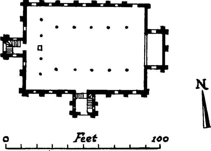
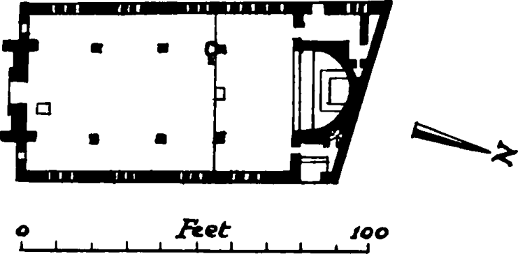
All Saints' Church, Buxton Street, 1839, plan. Based on the Ordnance Survey 1873–5
The church was a wide aisleless building, seven bays in length, with a small rectangular sanctuary at the east end, lit from the north and south. It had an open timber roof with tie beams, and a gallery on three sides supported by cast iron columns. There was no central aisle between the pews and a three-decker pulpit stood directly in front of the semi-circular sanctuary arch, which was decorated in red. The principal entrance was beneath a tower placed centrally on the south side, and at the west end was a secondary entrance with a staircase to the gallery. Externally the building was constructed of stock brick with dressings of Bath stone and hard grey brick, the roof being slated. It was intended to be in the Norman style and each bay contained a pair of tall and narrow round-headed windows beneath a semi-circular relieving arch, flanked by stepped buttresses rising to a corbel table. The low tower, also buttressed, had a gable containing a clock face on its three outer sides, and was topped by a squat spire in two stages.
When first built the church could seat a congregation of between 1,100 and 1,200, (fn. 50) but it underwent many alterations before its final demolition. The north and south galleries were removed in 1879 and the western gallery in 1903 or shortly afterwards. The central pulpit had been removed between 1859 and 1866 and the pews rearranged to form a central aisle, perhaps at the same time. Descriptions of the original appearance of the interior are given in The Ecclesiologist, No. xii–xiii, August 1842 (page 195), and in The Civil Engineer and Architect's Journal, volume iii, January 1840 (page 39).
In 1894 the spire was taken down, because of deterioration in the stonework, and the tower was heightened and given a remarkably ungainly saddle-back roof above a corbelled gallery. The church survived the war of 1939–45 with superficial damage, but under the 1951 reorganization of parishes in Stepney, the parish of All Saints was joined to Christ Church, Spitalfields, (fn. 47) and the building was demolished.
The vicarage and church hall are to the west of the church beyond Shuttle Street. The vicarage is a plain stock brick house of three storeys in the Gothic style of the earlier nineteenth century, with hood mouldings above some of the windows, probably introduced at a later date. The church hall, known as Hanbury Hall, was built later in the nineteenth century. After the closing of the church, these buildings were transferred to the use of Christ Church, Spitalfields.
Spicer Street British School and All Saints’ C.E. School, Buxton Street
Spicer Street British School demolished
Widespread illiteracy amongst the poor children of the Spitalfields area was revealed by the visits of the members of the Soup Ladling Society, which was formed in 1797 (see page 126). To deal with this problem a new society was formed under their auspices. Some of its members, such as Peter Bedford, Thomas Fowell Buxton, Joseph Allen and William Allen, were already active in the work of the soup kitchen. Other prominent founding members included Dr. George Birkbeck, Joseph Jackson Lister, Thomas Richardson and the Rev. Josiah Pratt. (fn. 51)
The society planned to open schools for 1,000 boys and 500 girls. No rooms large enough for this purpose could be found, (fn. 51) so in 1811 a site on the north side of Spicer(now part of Buxton) Street was taken on a ninety-nine-year lease, (fn. 52) and a schoolroom 104 feet by 42 feet erected. This was opened on 3 February 1812 as a boys' school under Thomas Harrod, a former assistant of Joseph Lancaster. (fn. 53) Although many of the founders were Quakers, the school was non-sectarian, and any child between the ages of six and fourteen years was to be admitted either on the payment of one penny per week (fn. 53) or on the nomination of a subscriber. (fn. 54) By 1816 the school committee was no longer able to grant this privilege to subscribers, and the widespread poverty in the area made it impossible for many families to pay the penny fee. The average attendance was only 500 and a debt remained on the buildings. (fn. 54) The girls' school building appears never to have been built.
Between 1833 (fn. 54) and 1840 the school was closed, and its site taken over by the new National Schools of All Saints' Church. The school is said (fn. 53) to have had a later connexion with the charity school in Abbey Lane, Bethnal Green. (fn. 55)
All Saints' National School was founded in 1840 by Robert Hanbury to serve the district chapelry of the newly completed Church of All Saints. (fn. 56) The trustees of the Spicer Street British School assigned the lease of the site to the Rev. Henry Taylor, the incumbent of All Saints' Church, and Robert Hanbury, brewer, and new buildings (Plate 43a), bearing the date 1840, were erected. (fn. 52) They are of two storeys and are constructed of stock brick with a slated roof, in the same style as All Saints' Church. There was a central entrance on the south side, below a gable, formerly flanked by pinnacles. In 1895 the freehold of the property was purchased and in this and the following year various alterations and additions were carried out. The buildings are now disused.
St. Anne's Roman Catholic Church, Presbytery and Church Hall, Underwood Road
In 1829 land on the north side of Spicer (now part of Buxton) Street was purchased by trustees acting on behalf of the ’Spitalfields Catholic Charity School’. The site is now occupied by St. Patrick's R.C. Primary School (see page 272). School buildings were erected on the site shortly afterwards, and in 1848 Father William Young, an Irish priest, began to use them on Sundays for the celebration of Mass. Father Young had previously served with great zeal in Cornwall, but was attracted to Stepney by the plight of the Irish immigrants who arrived in the neighbourhood in large numbers during the Irish potato famine. In 1849 his health failed and his work was taken over by Father Quiblier, a French Sulpician priest who had previously worked in Norwood. (fn. 57)
On 19 November 1850 Father Quiblier gave official notification of his intention to open a chapel under the name of St. Anne's, in Spicer Street. (fn. 57) On 31 December 1850 the chapel (which was now licensed as a place of public worship) was registered for the solemnization of marriages. (fn. 58) This first chapel in Spicer Street presumably occupied the school-house.
Father Quiblier had already realized that his task in Mile End New Town and the surrounding districts was so great that it ’needed the organization and teamwork of a religious order if it was to be properly done’. (fn. 57) He therefore sought the help of his friend, Father Colin, founder and Superior General of the Marist Fathers. It was agreed that members of the order should take over the mission, and the first Marist Fathers arrived in September 1850; within a few months a community of six priests had been established. In 1852 Father Quiblier retired to the Sulpician home at Issy, where he died on 17 September of the same year. His work is commemorated by a stained-glass window in the present church. (fn. 57)
In October 1850 land at the south-west corner of Underwood Street (now Road) and Albert (now part of Deal) Street was purchased from John Cookson and his mortgagees. This site was bounded on the south by land bought by the trustees of the school connected with the King Edward Street Ragged School (see pages 272), and on the west by a strip of land intended for a southerly extension of Charlotte Place (now the western extremity of Underwood Road). In 1851 this proposed extension was abandoned, and the Marist Fathers were able to buy the strip of land, which was some eighty-five feet wide, and so became possessed of a site adequate for both a church and presbytery. (fn. 9)
The architect of the buildings now to be erected was Gilbert R. Blount of 6 Duke Street, Adelphi. He is said to have been a pupil of A. W. N. Pugin (fn. 59) and is known to have designed a number of Roman Catholic churches, including that of Our Lady and St. Catherine of Siena, Bow Road. (fn. 60) He submitted plans for the presbytery of St. Anne's to the Office of Metropolitan Buildings in December 1851 and January 1852, (fn. 61) and the building (Plate 44b) was completed in 1852. (fn. 57)
In April 1853 Blount submitted plans for the church. The application included a plan and section (Plate 44a, fig. 69) showing that the church was intended to comprise a nave, transepts and chancel, with a central tower carrying a tall octag- onal spire. The builders were Messrs. Locke and Nesham of Theobalds Road. (fn. 62) The chancel was to be for the use of the community and the nave for the laity. (fn. 57)
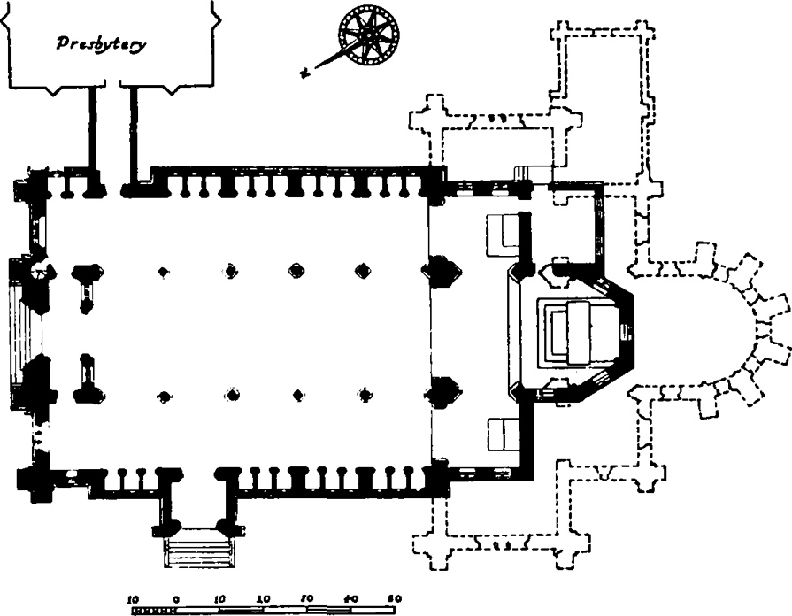
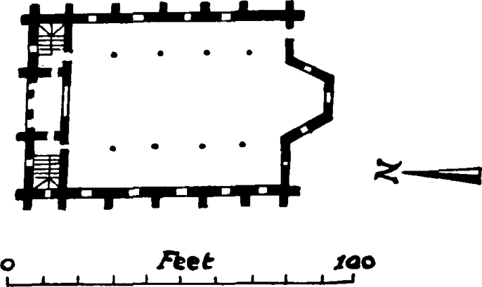
St. Anne's Roman Catholic Church, Underwood Road, 1855, plan. Re-drawn from original plans in the Office of Metropolitan Buildings
The nave was completed in 1855 and was orientated north and south. The altar was placed in a temporary apse at the south end, and the first Mass was said on 12 September 1855. The church was completed in 1894 to a reduced plan, omitting the transept and steeple, and with other small deviations. The marble altar was added in 1901, and the church was consecrated in 1905. The altar rails were erected in 1935 and the marble pulpit in 1939. (fn. 57)
The church (Plates 44, 45) is designed in the thirteenth-century style and is built of Kentish ragstone and ashlar dressings, with a slated roof. It consists of an aisled nave, six bays long, and a chancel of two bays, with a three-sided apse. Flanking the first bay of the chancel are a pair of chapels, dedicated to Our Lady and to St. Anne.
The northernmost bay of the nave, which is half the width of the other bays, is occupied by a vaulted lobby, above which is an organ loft, extending into the church with its polygonal fronts supported on two columns. Projecting from the second bay of the west aisle is a porch, which has now been converted into a chapel, and the outer wall of each aisle is lined with confessionals arranged between the buttresses.
The nave arcades are supported on clustered columns, their caps carved with formalized or naturalistic foliage, and the outer mouldings of the arches are stopped by figures of angels carrying religious symbols. The paired lancet windows in the clerestory are set behind coupled arches, which have hood-mouldings with carved human heads as stops, and are flanked by shafts with foliage caps. The open timber roof has arched, collar-braced trusses, springing from corbels adorned with angels playing musical instruments. Over the aisles are penthouse roofs having timber arches against each pier. The aisle windows are paired lancets, treated as in the clerestory, and below them the openings to the confessionals form triple arcades.
A high arch opens into the chancel, which has a vaulted roof and is enriched with stencilled decoration. The first bay is open to the side chapels but the rest of the lower stage is blank, except for a doorway to a sacristy on the east side. The tall, two-light windows have cusped heads with cinquefoil openings above. The altar is an imposing structure of white marble, with an arcaded and pinnacled reredos rising above the sills of the windows behind. The roofs of the two side chapels are vaulted, but in a curiously awkward manner.
The exterior is generally simple in character, and although nothing is scamped, interest is concentrated on the north front, a design showing French influence. The central bay is crowned by an arcaded gable and flanked by square buttressed turrets, with unexpectedly aggressive upper stages and tapered roofs. In the centre is a large rose window of elaborate design and below it a wide, arched doorway, with four receding orders. This is set beneath a steep gable, with a narrow gable on either side, each containing a small niche. In the ends of the aisles are three-light windows with geometrical tracery, and flanking the whole front are gabled angle-buttresses, supporting octagonal pinnacles.
The presbytery, with its garden wall and covered passageway, is constructed of the same materials as the church. It is a symmetrical, three-storeyed building, with gables, and buttresses of triangular section. The doorway is beneath a steeply pointed arch, and the windows are narrow, with cusped heads, and are employed singly, or in twos and threes beneath relieving arches.
The two buildings form a group of some distinction, and the interior of the church is particularly well designed, the stone carving being of very high quality.
The church hall, which stands to the south of the church, was also built from designs by Gilbert Blount. Tenders were invited in April 1858, that of a builder named Kelly for £1,130 being accepted. (fn. 63) The hall is a plain L-shaped building of one main storey, with stock brick walls and a steep, slated roof pierced by small dormer windows. The principal windows have four lights under a simple segmental head and the two doorways have pointed arches. In the 186o's it housed a grammar school run by the Marist Brothers.
St. Patrick's R.C. Primary School, Buxton Street, and St. Anne's R.C. Primary School, Hunton Court
In 1825 Roman Catholic schools known as the ’Institution of the Spitalfields Catholic Free Schools’ existed in the district. (fn. 57) Their position is not known, but in 1829 land on the north side of Spicer (now part of Buxton) Street adjoining the west end of Mile End New Town workhouse was purchased from George Fournier by trustees acting on behalf of the ’Spitalfields Catholic Charity School’. (fn. 64) Between 1831 and 1833 a building containing two class-rooms was erected by William Bush of Warwick Lane, London, builder, at a cost of £550. (fn. 9) The school provided for the ’religious and secular education of poor boys and girls or of poor children of either sex alone in conformity with the principles and practice of the Roman Catholic Church’. (fn. 65) In 1848 Father William Young began to use the school on Sundays for the celebration of Mass, and in 1850 Father Quiblier opened a chapel ’under the title of St. Anne's Chapel, Spicer Street’, presumably in the existing school buildings (see page 270).
After the mission established by these two priests had been taken over by the Marist Fathers, the Marist Brothers took over the teaching of the boys in the school in Spicer Street in 1853 on condition that other accommodation was found for the girls. (fn. 57) In the latter part of the nineteenth century the buildings were enlarged.
The girls from the Spicer Street school moved to premises in Underwood Street (now Road), probably a private house, where they were taught by Mrs. Mary Macarthy. (fn. 66) In 1857 a site for a permanent school on the north side of Hunt (now Hunton) Court was acquired and in the following year the Marist Sisters agreed to come from France to take over the school. The Sisters lived temporarily in Osborne Place, (fn. 57) but in 1862–3 a convent and school were built in Hunton Court to the designs of Gilbert Blount, the architect of St. Anne's Church. (fn. 9) The school occupies a tall, stock brick building of three storeys, raised on a semi-basement. The roof is slated and the design is of the simplest character, with some slight Gothic detailing. The main entrance to the school premises is from Underwood Road.
The parish had other schools at various times. Between 1853 and 1856 schools were held temporarily in Butler Street and New Street and in 1856 in Princes Street. In the late 1860's the Marist Brothers established a grammar school for boys in the church hall. The number of pupils varied between forty and fifty, and the school was closed about the year 1890. (fn. 57)
No. 19 Deal Street
Formerly King Edward Institution and George Yard Mission, etc.
In 1850 John Cookson and his mortgagees sold a plot of land on the west side of Albert Street (now part of Deal Street) to a group of sixteen persons amongst whom was the Rev. William Tyler, minister of the chapel in Church (now part of Hanbury) Street, later known as Trinity Congregational Church (see page 281). The land was to be used as a site ’for a school or schools for adult persons and children or children only of the vagrant and other poor classes of a houseless and outcast character’, and for a house for a schoolmaster and mistress. General elementary instruction was to be provided, the Bible was to be read daily, and no child or adult was to be required to learn any catechism or to attend any church or Sunday-school to which the parent or guardian might object on religious grounds. (fn. 42)
The deed of purchase also provided that until April 1851 a committee of twelve of the grantees should manage the affairs of the school, and that thereafter a committee of twelve to twenty-four persons should be elected annually by anyone subscribing half a guinea a year. (fn. 42) This committee or group of trustees was evidently the same as that which managed the King Edward Ragged School and Mission67 (see page 284).
It is not clear whether any buildings were erected on the site at once. In 1864 a ’residence and dormitories’ were built, James Harrison (who also designed the ’Church for the Ragged Poor’ in Kingward Street, see page 284) being the architect; contractors' tenders ranged from £1,047 to £1,192. (fn. 68) This building (Plate 46d) consists of two large rooms, one above the other, over a high basement, the lower room having a gallery across its northern end and the upper one being open to the roof. The front is in the ’Elizabethan’ style, built of red brick diapered with black, and with stucco dressings and a slated roof. It is five windows wide, with an entrance at either end set in a shallow, gabled wing. The doorways have pointed arches with enriched spandrels and the windows are square-headed with timber mullions and transoms. At the rear are two stone staircases, corresponding to the entrances, and an extension to the north contains the master's house with a bay window running up its full height.
In 1864 the institution was called the ’King Edward refuge’. (fn. 68) In 1872 it was officially recognized as an industrial school under the name of’King Edward Industrial School for Girls’. (fn. 69)
The Ordnance Survey map of 1873 marks the site as ’Ragged School and Orphanage’. The later history of the King Edward Ragged School and Mission, of which the Deal Street premises formed a part, is described on page 284. The buildings in Deal Street are now used for commercial purposes.
Deal Street Metropolitan Association Estate
Among the more interesting buildings remaining in Mile End New Town are those which comprise the second estate of the Metropolitan Association for Improving the Dwellings of the Industrious Classes, founded in 1842 and incorporated by royal charter in 1845. The aim of the Association, whose early members included the Earl of Carlisle, Viscount Ebrington, Lord Haddo, and Sir Ralph Howard, was to provide model housing on a sound financial basis. (fn. 70) Its first completed undertaking was a large block of family dwellings in St. Pancras. (fn. 71) In 1846 the Association refused a site behind Millbank Prison, which was offered by the Commissioners of Woods and Forests, and attempted unsuccessfully to acquire land in the newly formed Commercial Street, Spitalfields, for two blocks with a court-yard between them. (fn. 72) The site which the Association purchased from John Cookson and his mortgagees (see page 268) in 1848 for £1,300 (fn. 73) was bounded on the north and west by two new roads, now Underwood Road and Deal Street. To the east lay the property of Messrs. Hanbury and to the south a strip of land on the north side of Pleasant Row which had been developed in the latter half of the eighteenth century. In the summer of 1848 a competition was held to provide a design comprising two buildings, one a block of family dwellings and the other a model lodging house for single men. The successful candidate was William Beck, but designs were also received from Barnett, Grellier, Daukes and Ricardo, all of which were exhibited publicly. The Builder commented on the exhibition, commending the quality of all the work and remarking on certain similarities, due probably to directives from the Association. Daukes, Barnett and Ricardo seem to have designed in the Italo-Romanesque style which was already a feature of the newer East London churches, using heavy cornices, round-headed windows, rustication and massive detail. The preferred material throughout was yellow or white brick with red trimming, later to become standard in this type of building. Daukes submitted an interesting plan for a block of dwellings in which the four upper storeys were paired to form a series of two-floored maisonettes. These were joined by iron access balconies with corner staircases, set in open loggias. At this date the only example in England of such balconies was to be found in a block of dwellings in Liverpool, (fn. 74) but the idea was available from Continental literary sources. (fn. 75) Beck received the commission for the practical merits of his designs rather than for his external treatment, which was more conventional than that of the other competitors. (fn. 76)
The lodging house was commenced on the southern portion of the site late in 1848, and was opened in December 1849 (Plate 76a, fig. 70). The contractor was Samuel Grimsdell, whose tender was for £9,565. (fn. 77) The building, called ’The Artisan's Home’, was given a considerable amount of attention by the architectural press, as the first of its kind in the country. (fn. 78)
It has four storeys above ground level and is faced with stock brick, the dressings being of red brick and stucco. The plan is U-shaped, and the ends of the wings project slightly on the front elevation and are crowned with pediments. The centrepiece of Classical design, which rises through three storeys. As originally planned, the wings contained dormitories, and the short cross arm held the staircase and sanitary facilities. The dormitories were divided into long rows of cubicles opening on a central corridor, with half a window to each. The ground floor was given over to the superintendent's quarters and public rooms, the chief of which was a coffee-room measuring forty-five by thirty-five feet and occupying the space between the long wings. Columns divided the room into a central area with two side aisles, the latter filled by built-in tables and benches. The roof, of open construction, was finished in stained timber with skylights, and the end wall was pierced by a large Venetian window with a smaller window to each side. Some contemporary critics considered this room too grand for its purpose. (fn. 79) A library, reading-room, kitchen and cook's hatch for prepared meals were also provided. In the basement were baths, washing facilities and meat safes.
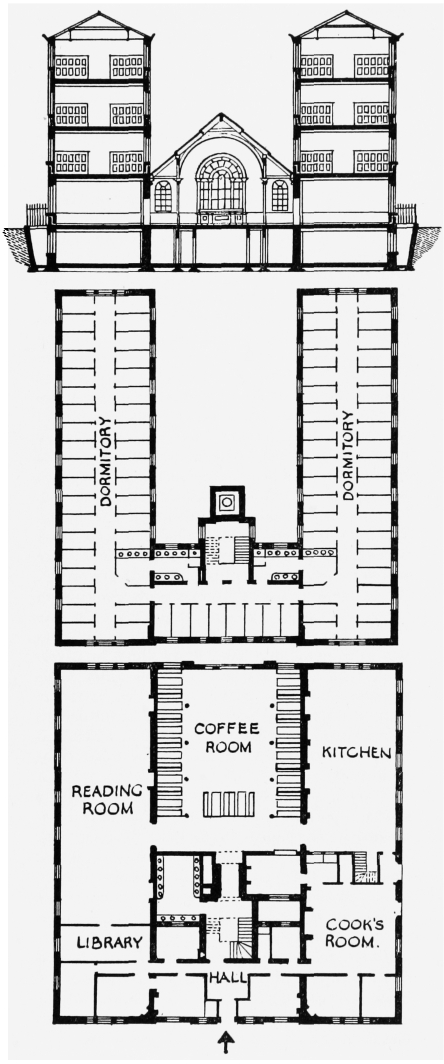
Metropolitan Association's Model Lodging House (now Howard Buildings), Deal Street, plan and section. Re-drawn from Tie Builder
The Builder (fn. 78) had early expressed doubts about the suitability of the designation ’Home’, and its fears were realized, for over the following twenty years the model lodging house, like others in London, did not prove successful. (fn. 80) The rules and regulations which went with the advantages of the place had little appeal, and many men preferred the cosy camaraderie of the common lodging houses, despite their disgraceful state. Accommodation was provided for 234 men, but there were rarely more than 157 lodgers. It became clear that the Association could not continue to operate so unprofitable a venture, and in 1869 the building was converted into dwellings for forty-six families, under the name of Howard Buildings. (fn. 70) The dormitories were subdivided into rooms, some or the windows made into doors, and external iron access galleries added, entirely transforming the side elevation of the building. The new flats were occupied in 1870. Between 1877 and 1879 the building was extended eastward to accommodate thirty-seven more families. (fn. 70) This addition does not continue the style of the original building.
Work was started on the block of family dwellings in 1849 (fn. 81) and completed in 1850 (fn. 70) (Plate 76a). The building is L-shaped in plan and five storeys high above the basement. Its internal arrangements were similar to those of the earlier buildings in St. Pancras, and according to a contemporary description in The Builder, (fn. 82) consisted of a series of staircases giving access to two dwellings on each floor. These contained a living-room, two bedrooms and a scullery with sink, dust shoot and lavatory (fig. 71). Such self-contained sculleries were a debatable feature at a time when cholera and fever were believed to be caused by the gases from drains. An elaborate system of built-in ventilation was designed to overcome any such danger. The building was of fireproof construction, based on a use of cast iron joists. (fn. 83)
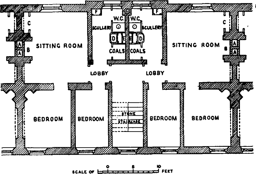
Plan of two typical flats in Metropolitan Association's Albert Buildings, Deal Street. Re-drawn from The Builder
Externally the facing materials are again stock brick with red brick and stucco dressings. The ground storey is banded in red brick and at the level of the first and third floors there is a broad band of stucco, the cornice being of the same material. The main elevation, facing north, is modelled to provide three shallow projections, and is lacking in central emphasis. Despite this fault and also an awkwardness in the fenestration, both this building and the lodging house retain some of the dignity of an earlier period.
With the completion of the initial project, the Association further enlarged the site of the estate by the acquisition of a strip of land fronting on what was then Pleasant Row and Pelham Street. The freehold was purchased from the trustees of the will of the late Sir George Osborn in 1850, together with two terraces of houses (presumably of late eighteenth-century date) which then stood on the site. (fn. 41) At first the Association let these houses out as they were, but by 1857 those in Pelham Street required such extensive repairs that they were pulled down and replaced by two parallel terraces of cottages with a separate dwelling on each of the two floors, thus accommodating thirty-two families (Plate 76b). Three shops were also provided. (fn. 70) These two terraces were known as the Albert Cottages, and in 1865 they were duplicated by the Victoria Cottages for thirty-six families, which replaced the old houses on the Pleasant Row site. (fn. 84) The architect is not known. Each flat consists of a living-room, bedroom, scullery, and sanitary facilities, and each has a separate entrance paired with that to the adjoining flat. Two terraces are built in ’white’ brick and two in stock brick, with red brick dressings and slated roofs. One terrace in either group faces on to a foot-way with a small front garden to each cottage.
The Albert and Victoria Cottages were intended for those who could not afford the higher rents of the family dwellings. The Association had the example already set by the first project of the Society for Improving the Condition of the Labouring Classes in Bagnigge Wells, Gray's Inn Road, (fn. 85) and the Prince Consort's model houses for the Great Exhibition of 1851. (fn. 86) Nevertheless, they were criticized for using the land to provide housing of such a low density. (fn. 80) It appears that the first project had been to use the site for other large blocks, but instead the Association experimented on an urban estate with a type of model housing more typical of country or suburban districts. During the war of 1939–45 the Victoria Cottages facing into Woodseer Street were partially destroyed by bombing.
No. 27 Spital Street
Demolished
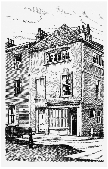
This house (fig. 72), which still survived in 1930, appeared to date from the very early eighteenth or possibly from the late seventeenth century, and was of the type associated with the silk-weaving industry. It was a corner house of three storeys with a garret in the roof. It was built of brick which had been covered with stucco, and the hipped roof was pantiled and had projecting eaves. The ground storey was largely occupied by a shop and the storey above had sash windows of a late date. On the Buxton Street front the level of the second floor was marked by a broad band and this storey was lit by two very broad windows with timber mullions, that facing Spital Street having a segmental head with a keystone. (fn. 87) Houses of similar character and date still survive in Granby Street and Sclater Street, Bethnal Green.
No. 27 Spital Street. Re-drawn from a photograph of 1928
No. 12 Hunton Street
Formerly No. 12, previously No.11, Hunt Street
This is a four-storeyed, stock brick house with a basement, of the type occupied by silk weavers. Despite a rough inscription on the front ’rebuilt 1851’ it dates most probably from the late eighteenth century, though a slightly later date is not impossible. The rebuilding must have been of a very limited character. There are two intercommunicating rooms on each floor lit by very wide four-light windows under segmental arches. A twisting stair rises immediately beside the entrance and has narrow windows at mezzanine level on the street-front. The doorway has a round-arched head and the window beside it is not as wide as those above. The house is now ruinous.
Nos. 14–32 (even) Hunton Street, Nos. 1A, 1–9 (consec.) Hunton Court, and Davis Avenue
Formerly Nos.14–28 (even), 34 and 36 Hunt Street, and 1a, 1–9 (consec.) Hunt Courl (or Davis Terrace)
Davis Avenue, the south side of Hunton Court and Nos. 14–32 (even) Hunton Street were built by Moses Davis, architect and surveyor, of Kilburn, between 1893 and 1895. (fn. 88) Nos. 14–32 Hunton Street are three-storeyed houses, two windows wide built of stock brick with stone and red brick dressings and slated roofs. Door and window openings have segmental heads except on the second floor where they are square-headed. The cornice and string courses are of moulded brick. Nos. 1–9 Hunton Court are identical with Nos. 14–32 Hunton Street. No. 12 Hunton dows wide and consists of two storeys above a high basement. The central doorway, which is level with the pavement, is enriched in moulded brick. Davis Avenue (Plate 77d) consists of a pair of Nos. 14–32 Hunton Street, facing each other Street through a surprisingly opulent gateway of wrought iron. On the ground floor are flats and the two-storeyed dwellings above are approached by central staircases and first-floor galleries with cast iron balustrades. The southern terrace is dated 1894 in a small central gable and the northern terrace similarly 1895.
Nos. 2–16 (even), 1–39 (odd) Underwood Road
Underwood Road was formerly Underwood Street. Nos. 2–16 (even), previously Nos.1–8 (cansec.) Charlotte Place; Nos. 1–13 (odd), previously Nos. 1–7 (consec.) Albert Places Nos. 15–39 (odd), previously numbered 1–13 (consec), Underwood Street
Nos. 2–16 (even) Underwood Road and No. 50 Buxton Street arc probably the work of Mr. Simson, builder, of Spicer Street; they were all built between 1846 and 1848 (fn. 38). They are stock brick houses, of two storeys, with garrets in the slated mansard roofs. The ground storeys are stuccoed and there are dressings of the same material. Each house has a three-light casement window on the first floor and Nos. 14. and 16 have small panels modelled with lions in high relief above the ground-floor windows.
Nos. 1–39 (odd) were all probably the work of J. H. Dew, builder, and date from between 1850 and 1855. (fn. 89) Nos. 1–13 (Plate 75c) are two-storeyed houses, and each two windows wide, with stock brick fronts, a first-floor sill-band and crowning entablature of stucco, and slated roofs. The row is distinguished by a moulded panel, flanked by consoles, which breaks through the blocking-course above the central house. Nos. 15–39 are similar, but have no central feature.
Nos. 50–88 (even), 55–85 and 121–127 (odd) Buxton Street
Nos. 50–88, formerly No. 47 Spicer Street and Nos. 42–25 (consec.) Buxton Street; Nos. 55–85, formerly Nos. 9–24 (consec.) Buxton Street; Nos. 121–127, formerly Nos. 7–4½ (consec.) Luke Street
Nos. 52–88 (even) and 55–85 (odd) are all presumably the work of J. H. Dew and W. Blenkarn, builders (Plate 75a, 75b); Nos. 52–88 and 61–85 date from between 1847 and 1850, while Nos. 55–59 (forming part of a long terrace the rest of which was bombed) were erected some five years later. (fn. 39) No. 46 was built in 1846–7 by Mr. Simson. (fn. 38) They are built of stock brick with slated roofs, in four two-storeyed rows. East of Deal Street the houses have a coursed stucco facing to the lower storey and the upper windows are set in a shallow semi-circular arcade. The corner houses rise above the others and contain a shop and a public house. West of Deal Street the houses are similarly constructed but are later in style, the upper windows are in pairs, with round heads, and there was formerly an open balustrade screening a garret in the mansard roof.
Further east Nos. 121–127 (odd) are two-storeyed cottages of the very poorest type, built of stock brick with pantiled roofs, the single window on each floor having a segmental head under a rough brick arch. Even these cottages are given a parapet on the street front. They are probably survivals of the first development of Luke Street between 1819 and 1824.
Nos. 11–29 (consec.) North Place
North Place was formed as a cul-de-sac on the the narrow strip of ground between Buxton Street and the northern boundary of the Tylney estate. Building appears to have been started in about 1848 by J. H. Dew and W. Blenkarn and completed by Dew between 1850 and 1852. Nos. 11–18 (Plate 75d) are a row of two-storeyed cottages, built of stock brick with slight stucco dressings and pantiled roofs. The openings are square-headed and each cottage is one window wide with a blank panel above the doorway. Nos. 19–29 are similar but entirely plain. They are each two windows wide and have round-arched doorways. The western end of the street was destroyed by enemy action in the war of 1939–45.
The Halifax Estate
In 1643 Edward Montague, esquire, of Boughton, Northants, William Montague, esquire, of the Middle Temple, and Mawrice Tresham, esquire, of the Middle Temple, purchased property in the future Mile End New Town and also in Spitalfields (see Chapter XV) from William Smith, esquire, of the Middle Temple, and others. This included forty-two or forty-three acres divided into five closes, ’a nurcery and garden plott’. (fn. 90) Part of this was to become the southern half of Mile End New Town. All this land had, by about 1680, come into the possession of Edward Montague of Horton, Northants. (fn. 91) Pelham Street, one of the earliest roads to be laid out, took its name from Edward Montague's wife, who before her marriage had been Elizabeth Pelham. (fn. 12) In 1691 she obtained a private Act enabling her to grant leases of her estate both in Spitalfields and Mile End New Town for the rebuilding of dilapidated property (see page 238). The two estates passed to their son, George Montague, who became second Baron Halifax and first Earl of Halifax of the third creation, following the death of his uncle, Charles Montague, Earl of Halifax, in 1715. He was succeeded in 1739 by his son, George, second Earl, who adopted the name of Montague-Dunk on his marriage to an heiress, Ann Dunk, in 1741. The title lapsed on his death in 1771, and the Mile End New Town estates passed to his nephew, Sir George Osborn, baronet, son of Sir Danvers Osborn of Chicksands Priory, Bedford. (fn. 12) The whole property remained in the Osborn family until 1849, when over half of it was sold to redeem mortgages. (fn. 92) Most of the remainder has been sold by the Osborn family in recent years.
Building development seems to have begun in the 1680's, at the same time as that in Hares- marsh to the north. In a six-acre area immediately east of Brick Lane, known as Bradshaw's Close, Pelham Street (now Woodseer Street between Brick Lane and Spital Street), Montague Street (marked on Rocque's map as the eastern arm of Brown's Lane, now Hanbury Street between Brick Lane and Spital Street) and Booth Street (now Princelet Street between Brick Lane and Spelman Street) were laid out. Further east Montague Street was continued as Well Street (now Hanbury Street between Spital Street and Greatorex Street) and Church Street (now Hanbury Street from Greatorex Street to Vallance Road). Pelham Street was intended to continue further east: Gascoine's map of 1703 shows it stretching across the northern part of the open meadow known as Coverley's Fields. Running north and south were three short streets, now the southern portion of Spital Street, Silver Street (also called White Cross Street, now the northern end of Spelman Street) and Lombard Street (now Daplyn Street). To the south of Church Street was the High Street (now part of Greatorex Street), which formed the main thoroughfare leading to Whitechapel, and closed at its lower end by a barrier, whose removal was authorized by an Act of 1780. (fn. 93) Further east was King Edward Street (now Kingward Street) with Duke Street (now Dunk Street) projected as a third north-south road halfway between the High Street and King Edward Street. South of Booth (now part of Princelet) Street and west of High Street lay an area of ’Garden Ground in the occupation of Martin Girle. (fn. 94)
In March 1680/1 Edward Montague granted a lease of Bradshaw's Close to Nicholas Booth, citizen and carpenter of London. (fn. 5) Booth then granted a series of sixty-one-year sub-leases, in which the customary yearly peppercorn of the building period was replaced by a bottle of sack. Not all the sub-lessees were builders. They included a chandler, haberdasher, weaver, clothworker and blacksmith. The builders included William Martin, John Goodman, Richard Janeway and Thomas Dellar, carpenters, Robert Martin and Thomas Slemaker, bricklayers, and Robert Hart and John Stevenson, plasterers.
Nicholas Booth died before 2 January 1683/4, (fn. 95) but his wife carried on the building development, erecting one house herself (which she leased) and granting leases of other sites. (fn. 96)
Meanwhile, pockets of buildings were appear ing along the newly laid-out streets to the east. Alexander Cook, carpenter, and James Drew, bricklayer, both of London, built ten houses in the south-eastern part of High Street in 1686. (fn. 97) More building was started by Nicholas Bell, carpenter of London, at the south-east corner of Church Street and King Edward Street, on ground leased from Henry Burman and Edward Probee in 1684. (fn. 98) Bell built only three houses and the work was taken up and continued by William Heatley, a Stepney bricklayer, who built a row of some twenty houses on the south side of Church Street, east of King Edward Street, on ground leased from the executors of George Dashwood. (fn. 99) Heatley also leased a portion of the north-west side of King Edward Street from Edward Probee in 1684 and began the construction of nine houses there. He seems to have run into financial difficulties, and been unable to complete the work. His mortgagee, Joseph Alford, draper, completed two of the houses in 1694. (fn. 100) Henry Burman, Edward Probee and George Dashwood appear to have been lessees or sub-lessees of the Montagues in this portion of the estate.
Another lessee who seems to have held sites in both the Halifax and Cox (later Tylney) estates was Samuel Norris of Shoreditch. He granted leases of land at the junction of Church Street and Well Street, at the point where Dover Street was to have run northward to Pelham Street. Samuel Mann, carpenter of Whitechapel, built two brick houses here on sites leased from Norris in 1687, (fn. 100) and Nicholas Bell built at least one house on an adjoining site, leased in 1683. Dover Street did not materialize, but Horwood's map of 1799 shows an empty piece of land at the junction of Church and Well Streets marking its intended site.
Norris seems to have given his name to a short stretch of the west end of Church Street, called ’North Street’ by Gascoine in 1703 and ’Norris Street’ by Foster in 1739. A house adjoining the property leased to Nicholas Bell was built c. 1694 by William Daintry, weaver. (fn. 100)
Well Street may take its name from Anthony Wells, bricklayer of Stepney. In 1682 he obtained a lease from Samuel Norris of ground on the north side of Well Street. (fn. 101) He also held from the Earl of Halifax by lease of unknown date a much larger area which extended from the north side of Well Street to the Common Sewer (the northern boundary of the Halifax estate), and from the east side of Spital Street to the border of Coverley's Fields. (fn. 102)
Other sites were held by Thomas Slocock, clothworker of Stepney, including one on the east side of Spital Street which was leased to him by Norris in 1684, and another in Pelham Street which he sub-let in 1689. (fn. 103)
After 1700 the scale of building development on the Halifax estate appears to have declined considerably. Gascoine, in 1703, depicts Mile End New Town as built up to a far greater extent than it can then have been, and it can only be assumed that he based his map on building plans which subsequently came to nothing. Grander schemes are shown on maps by Jeffreys in 1735 and George Foster in 1739. Pelham Street and Hunt Court are carried eastward in a sweeping curve, ending in Montague Square, a large open space approached from the west by two short streets. This intended development would have completely covered the open area of Coverley's Fields, lying north of Church Street and east of Deal Street. To the south, a new street called Christopher Street was to divide longitudinally the triangle of ground formed by Church Street, Long Street (or Princes Row, now Old Montague Street) and King Edward Street. Another short street between Church Street and Pelham Street and east of Deal Street was to be called Dolphin Street.
Rocque's map of 1746 shows how little building had actually taken place since 1700 in the eastern portion of the estate. The formation of Long Street east of High Street had not been completed, and there were only two small blocks of buildings on the north side. King Edward Street had only a few houses at its south-east corner and the terrace begun by Heatley on the west side. Dunk Street came to an abrupt stop at only a quarter of its projected length. The west side of High Street was fully built, but the centre of the east side was still empty. Half the north side of Church Street was still open to Coverley's Fields, where a large isolated building, probably a farmhouse, stood surrounded by trees and a small watercourse.
To the west there was more extensive development. In 1737 the Earl of Halifax granted a new sixty-one-year lease of Bradshaw's Close to Charles Booth of Marden, Kent, gentleman, the grandson of Nicholas and Catherine Booth. At that time there were 162 houses on the six-acre property. (fn. 104)
In 1717 the Earl of Halifax had leased what had been ’Girle's Ground’ or ’garden’, the twelve acres to the south of Bradshaw's Close, to John Ward, esquire, and William Mason, gentleman. The latter presumably built Mason's Court (now part of Chicksand Street), a short street of eleven houses, leading off the east side of Brick Lane, (fn. n2) but the development of this property went no further. (fn. 105) When the boundaries of the new Christ Church parish were drawn up in 1728, Mason's Court remained in Whitechapel parish.
The second Earl of Halifax, who succeeded to the title in 1739 at the age of twenty-three, seems to have pushed forward with building development. In 1742 he agreed to grant a lease of the land held by Anthony Wells, whose term was due to expire in 1744, to John Palmer and William Middleton, carpenters, of St. Martin's, Lud gate. (fn. 106) In 1744 he demised a smaller area, in Pelham Street, Spital Street and Well Street, to another London carpenter, Edward Grainge (or Grange), (fn. 107) perhaps the builder who had been active in Norton Folgate and Spitalfields (see page 184). There is reason to believe that Grainge did not build on this land, which came to him with fifteen houses already standing on it, but Palmer and Middleton were presumably active in building on their ground by as early as 1742. This may account for the well built-up character of this part of the estate in 1746 on Rocque's map.
In 1765 development of the area south of Church Street began when the Earl of Halifax leased to Robert Clavering, carpenter of Christ Church, land on a newly projected street to be called Halifax Street, which was to run in an east west direction between High Street and King Edward Street. Clavering granted sub-leases to other carpenters, who included John Wooding of Christ Church, Edward Marshal of Whitechapel, William Dunn of St. Anne's, Limehouse, Jonathan Lee of Islington, John Kirk of Clerken well, and a bricklayer, Thomas Stokes of Rat cliff. (fn. 108) Despite this activity, Halifax Street and the adjoining Dunk Street (formerly projected as Duke Street) were not completed at once. A conveyance of 1776 (fn. 109) lists the properties comprising the Halifax estate in Mile End New Town, and Dunk Street, Halifax Street and part of the east side of High Street appear to be then still unoccupied.
The conveyance of 1776 also shows that the eastern side of King Edward Street was still largely unbuilt. To the north Coverley's Fields remained unaltered, but Pelham Street (now Woodseer Street) was being extended eastward to their western boundary, and building on the north side of this extension, later called Pleasant Row, was under way, possibly sponsored by Charles Morton. In Deal Street, on the western limits of Coverley's Fields, there were scattered houses, and a large dyehouse, rented successively by Abraham Desormeaux, dyer, in 1745, Charles Dalbiac of Spital Square, weaver, in 1757, and Thomas Goode of Chiswell Street, handkerchief printer, in 1758. (fn. 110)
Building went steadily forward during the last quarter of the eighteenth century. Horwood's map of 1799 shows that High Street, Dunk Street, King Edward Street and Halifax Street had been completed. To the east of King Edward Street a new street, King Street and Queen Street (now Rowland Street) ran northward into Coverley's Fields, where Truman's had built extensive warehouses between 1776 and 1779. (fn. 111) These warehouses stretched from Church Street on the south to the Common Sewer on the north, and prevented the junction of Pelham Street and its eastern extension, Pleasant Row, with Queen Street. They also blocked the course of Unanimous Row, a short new street running west from Queen Street.
Between 1799 and 1819, the land known formerly as ’Girle's Ground’ was finally built up. Most of the new streets are already shown on Horwood's map of 1813, and when the third edition of his map was published in 1819, the development was nearing completion. Much of this building lies in the Whitechapel portion of the ground. The only areas lying in Spitalfields and Mile End New Town were Heneage Street (presumably named after Heneage Finch, daughter of the eighth Earl of Winchilsea, who became the second wife of Sir George Osborn), George Street (now Casson Street), John Street (now Spelman Street) and a portion of Chicksand Street. Portions of these streets and a short cul-de-sac called Ramar Place have now been absorbed into the Chicksand estate of the London County Council. At the same time three narrow streets or alleys were made eastward out of King Edward Street. These were called Johnson's Street (now Megg's Place), Ely Place (now Eele Street) and Spring Gardens (now Spring Walk). They were probably lined by small cottages, similar to those which survive in Spring Walk.
Other industrial and commercial concerns besides Truman's were moving into Mile End New Town during the late eighteenth century, as Horwood's map shows. Booth Street became an early centre of light industry, with a dye works, a calendering mill and the pewter and tinfoil works of Messrs. Townsend and Compton. This latter firm's premises incorporated a large garden with lime trees and a house said to have been a ’country lodge’ of Lord Halifax. (fn. 112) This building is clearly marked on Horwood's map of 1799. It was a large detached house, probably of the second half of the eighteenth century, since it is not shown on Rocque's map. It is described as having large windows, a porch and steps, and within, a wide staircase, panelled rooms and handsome mantelpieces. (fn. 112) The Ordnance Survey map of 1873 shows the house still standing. It must have been demolished between 1873 and 1878 when Perry's Avenue was built over the site.
The Ordnance Survey map of 1873 shows the further industrial development of Coverley's Fields. The brass and iron foundry of Messrs. E. and F. Wright on the west side of Queen Street, established in 1854, had swallowed up Unanimous Row, and there were also a saw-mill, timber yard, and fish-curing factory. A sugar refinery had been built immediately east of the original dyehouse in Deal Street.
St. Olave's Church, Kingward Street
Demolished
By the London City Tithes Act of 1864 (fn. 113) a fixed tithe of £2,600 per annum was apportioned to the rector of St. Olave's, Hart Street, of which £600 per annum was to be applied to church endowment. By an Order in Council of 31 March 1870, the rectory of St. Olave's, Hart Street, was united with the perpetual curacy of All Hallows, Staining, and the Rev. Alfred Povah, rector of St. Olave's, became rector of the united benefices, the patronage of which was vested in the trustees of the advowson of St. Olave's. In 1872 the trustees, the rector and the Bishop of London agreed that the rector should from his own resources, or by means of money under his own control, erect a church upon a site which had been provided by the Bishop of London's Fund, and which was to be conveyed to the Ecclesiastical Commissioners. The site was at the south-west corner of Church (now part of Hanbury) Street and King Edward (now Kingward) Street, within the parish of All Saints, Mile End New Town, and the church was to accommodate not fewer than 500 persons. After its consecration the church was to be endowed by the rector of St. Olave's, Hart Street. (fn. 114)
The foundation stone of the new church (Plate 43d, fig. 73) was laid by the Rev. Alfred Povah, rector of St. Olave's, Hart Street, on 25 June 1874. (fn. 115) The architect was A. W. Blomfield, (fn. 116) and the church was consecrated on 23 April 1875. (fn. 117) (fn. c1) In the same year St. Olave's was constituted a district chapelry of All Saints' parish, its district being the southern part of Mile End New Town. (fn. 4)
St. Olave's Church, Kingward Street, 1875, plan Eased on the Ordnance Survey
The church was destined to have a short life. At the end of the nineteenth century large numbers of immigrant Jews from eastern Europe settled in the area which it served, and in 1902 Charles Booth found that there was a Sunday morning congregation of only seven or eight, with some fifty people present for the evening service. (fn. 118)
In 1904 the building was in a very bad state of repair; the Bath stonework had decayed and been condemned by the borough surveyor. In 1914 the cost of the necessary repairs had become so great that the church was closed and the district which it served re-united with All Saints' parish. The building was demolished soon afterwards and the site purchased by the Stepney Borough Council; it is now a children's playground. The par sonage, (fn. c2) still survives immediately to the south of the site of the church. (fn. 117)
St. Olave's was a frugal version of thirteenth century Gothic, the red stock brick walls pierced by lancet windows and sparsely dressed with red brick and stone, and the steeply pitched roof slated. The building was orientated north and south and had an aisled nave of four bays with a semi-circular apse of the same height. The chancel encroached on the first bay of the nave, the east aisle being here raised to form a transept. Against the north-east face of the apse was an octagonal turret, capped with a low spire.
Trinity Congregational Church and Schools, Hanbury Street
Demolished
In either 1770 (fn. 119) or 1780 (fn. 120), a chapel of ease to Stepney parish church was established on the south side of Church Street (now part of Hanbury Street) in Mile End New Town by two clergymen, the Rev. Benjamin Worship and the Rev. William Hervey (fn. 121) (fn. n3) (nephew of the Rev. James Hervey, author of Meditations among the Tombs). Shortly after the chapel was built, one of the ministers died, and the other became involved in financial difficulties which led eventually to his being imprisoned. The building appears then to have been taken over by Nonconformists. (fn. 122) In 1795 Lysons described it as ’belonging to the Methodists of Mr. Whitefield's persuasion’. At about this time the minister was the Rev. John Cottingham (fn. 122) whose wife, Elizabeth, is said by Lysons in 1795 to have been buried in the chapel. (fn. 123) Cottingham died in Mile End New Town, and was also buried in the chapel. (fn. 122) He was succeeded in 1808 by the Rev. George Evans, a Calvinistic Methodist of the Countess of Huntingdon's Connexion, who had been minister of Red Lion Court Chapel, Spitalfields. (fn. 124) In 1810 the chapel is described as Calvinist (fn. 125) and in 1811 as Independent. (fn. 119) At this period the building was enlarged, to the detriment of the original structure. In 1823, as a result of a legacy, a new chapel was commenced on a site near Mile End Road. This building, called Brunswick Chapel, was opened in 1825. (fn. 124)
For a time the chapel in Mile End New Town appears to have been disused, but by 1829 it was being used by the Home Missionary Society, and services were being held there by the Rev, Joseph Drake and the Rev. Joseph Mason. In 1831 an Independent or Congregational church was formed under Mr. Mason. (fn. 126) He was followed in 1844 by the Rev. William Tyler, who came with his congregation from Hope Street Chapel in Spitalfields (fn. 127) (see page 113).
In 1859 the building had become unsafe for further public use and was ordered to be taken down by a magistrate of Worship Street Police Court, under the authority of the Metropolitan Building Act of 1855. (fn. 128) The congregation purchased the freehold for £2,418 and a new building was erected in 1861. R. Moffatt Smith of Manchester was the architect, and the contractor was Maers, whose tender was for £2,937; (fn. 129) the final cost seems, however, to have been considerably higher. (fn. 130) The new building (Plate 43b, fig. 74) was opened on 25 March 1862 as Trinity Congregational Church. It formed a broad galleried hall of five bays, with stepped buttresses and decorated windows, probably built of brick with stone dressings. Its style is described in a contemporary source as ’flowing decorated’ Gothic of the time of Edward III. (fn. 128) The entrance, at the north end, was through a triple arcade, and over a tall six-light window the gable rose to a square turret with a pyramidal roof. The gallery staircases flanked the entrance and at the south end was a three-sided apse. (fn. n4) The school, at the back of the site, was a single-storeyed building of the plainest type.
Trinity Congregational Church, Hanbury Street, 1862, plan. Based on the Ordnance Survey 1873–5
William Tyler remained minister until 1890. (fn. 127) The congregation was apparently a flourishing one, but many of its members lived at a distance. (fn. 131) In c. 1902 the congregation moved to Trinity Church, Broadway, Victoria Park, Hackney; (fn. 132) the chapel was demolished and in the following year the London School Board opened a new school upon the site (see below).
A charity school for sixty children was established in 1785 in connexion with the chapel of ease in Mile End New Town. When the chapel passed to the Nonconformists, the children continued to attend services there on Sundays, but the school was not restricted to the children of Nonconformists, and the catechism of the Church of England was taught. (fn. 133) For some years the school retained a connexion with Stepney parish church, and while the Rev. George Harper was rector (1801–15), special sermons were preached at St. Dunstan's on its behalf. (fn. 122) This is presumably the school for sixty children referred to by Lysonsin 1811 as'supported by the Methodists’. (fn. 134) It was originally conducted in class-rooms adjoining the house on the west side of the chapel. (fn. 122) In 1810 a new school-house was built in Dog Row, Bethnal Green, and the lease of the former buildings sold. When the Rev. George Evans and his congregation moved to Brunswick Chapel, the school children attended Sunday services there instead of at Mile End New Town Chapel, as formerly. (fn. 133)
In about 1808 Sunday-schools were established by the congregation of Mile End New Town Chapel in a rented building whose position is not known. When the congregation moved to Brunswick Chapel, school-rooms were built at the new site for the same purpose. (fn. 135)
It is not known whether the congregation which took over Mile End New Town Chapel established day or Sunday-schools from the first. But in 1848, soon after the Rev. William Tyler succeeded to the pastorate, a school-room (to be used as both an infant school and Sunday-schools) was erected in 1848 in the burial-ground adjoining the chapel, the builder being William Smith. (fn. 136) Another school-room was built behind the chapel in 1853 to house Sunday-schools; the builder was Joseph Clever. (fn. 137) These buildings were retained when the chapel was rebuilt in 1861, and can be seen on Plate 43b. The boys' school-house was transferred to the London School Board in 1872. (fn. 138)
Old Montague Street Elementary School
This school was built for the London School Board upon the site of the former Trinity Congregational Church (see above). The architect was T. J. Bailey and the contractors, whose tender for a school for 822 children was for £25,577, were Messrs. E. Lawrance. The school was opened on 16 March 1903. During the course of excavation for the foundations of the school it was found that ’underneath the Church had been buried a number of human remains, which had evidently been disturbed at the time the Church was built’. (fn. 139) This disturbance probably took place when the church was rebuilt in 1861. The bones were removed to the London Necropolis Company's cemetery at Woking.
A four-storeyed building of stock brick, dressed with buff terra-cotta and a little red brick, it is supported on piers of purple engineering brick, the ground storey being largely open. The main cornice occurs at third-floor level, the attic storey being more liberally dressed with terra-cotta than those below. The front to Old Montague Street consists of a five-bay block, surmounted by a broken segmental pediment and flanked by staircase towers with steep pyramidal roofs. A short continuation to the east ends with a pedimented wing. This is repeated on the north front which is otherwise a straightforward composition of ten bays.
The building was damaged by enemy action during the war of 1939–45, and in 1951 was declared redundant.
Hebrew Conference Hall, London City Mission, Old Montague Street
A chapel is shown on Horwood's map of 1799 on the north side of Princes Row (now Old Montague Street) between Dunk Street and King Edward (now Kingward) Street. Throughout the greater part of the nineteenth century there are isolated references to a chapel in Princes Row, but there is no evidence as to whether they do or do not refer to that shown on Horwood's map. In 1805 there was an Armenian chapel in Princes Row. (fn. 140) In 1811 a meeting of unspecified denomination is listed in Princes Row. (fn. 125) In c. 1824 there was one other dissenting meeting-house somewhere in Mile End New Town besides that of the Rev. George Evans (fn. 141) (see page 281). In 1838 there was an Armenian chapel in Princes Row. (fn. 142) In 1850 there was a chapel in Princes Street (i.e. the former Princes Row) near Dunk Street. (fn. 38)
In 1876 a building in Old Montague Street was registered as a place of worship by the London City Mission, which still occupies a building on the site shown by Horwood; the present building (fn. c3) dates from 1890.
Talmud Torah Classes, Hanbury Street
Formerly Hanbury Street School
In 1840 a site on the north side of Hanbury Street, near Vallance Road, was acquired by Jonathan Duthoit and six other trustees for the provision of a Sunday-school and day school to be administered according to the principles of the British and Foreign School Society. The school was to serve the children of the parish of St. Matthew's, Bethnal Green. (fn. 143) No further progress seems to have been made with the scheme until 1871, when building began with the help of ’funds received from the Baroness [Burdett] Coutts for the schools existing in Gascoigne Place, Shoreditch, required for improving the approaches to Columbia Market’. The architect was Thomas Chatfield Clarke, who later designed the Central Foundation School for Girls in Spital Square. The builders were Messrs. Hill, Keddell and Waldram and the cost about £2,300. (fn. 144) The building was of two storeys with accommodation for boys on the ground floor and for girls above. The street front, a poor imitation of the Butterfield manner, was built of stock brick with dressings of red brick and Bath stone, the roof being slated. It was four windows wide under a broad gable and to the east was a three-storeyed tower with a truncated pyramidal roof. The two doorways were gabled and the ground-floor windows had flattened triangular heads, those to the upper storey having pointed arches with cusping. In the main gable was a six-foiled opening and a small gable on the tower accommodated a clock.
The school was transferred to the London School Board early in 1872, and opened as an elementary school on 30 April 1872. The trustees retained the right to use the building on Sundays and some week-day evenings in connexion with the work of Trinity Congregational Church. (fn. 138) In 1879 Duthoit and the trustees granted the London School Board a ninety-nine year lease in which these rights were again reserved. (fn. 143) The school continued under the London County Council as a mixed junior school until 1915, when it was closed and the property leased for commercial purposes. It was sold in 1919 and was subsequently occupied by the Talmud Torah Classes of the Great Garden Street Synagogue in what is now Greatorex Street. The building is now derelict and partially demolished.
King Edward Ragged School and Mission, Kingward Street
The first known reference to the existence of a ragged school on the east side of King Edward Street (now Kingward Street) is contained in the schedule of an Act of 1849, authorizing the sale of part of the Halifax-Osborn estate. (fn. 92) A plan of the site made in 1859 shows that it then comprised a rectangle on the east side of King Edward Street, fronting north and south on Eele Place (now Eele Street) and Spring Gardens (now Spring Walk) respectively. In 1853 a group of trustees, which in 1859 included Jonathan Duthoit, the principal sponsor of the British schools in Hanbury Street (see above), and the Rev. William Tyler, minister of the chapel in Church (now part of Hanbury) Street (later known as Trinity Congregational Church), erected on this site a ’Church for the Ragged Poor of the Spitalfields District’. (fn. 145) The architect was James Harrison, and the builders were Messrs. Clever and Stanger of Haggerstone, whose tender was for £500. (fn. 146) The buildings comprise a main hall with an open timber roof, and a lower wing at the rear; they are built of stock brick with stone and red brick dressings. The hall has a pair of narrow round-headed windows and in the gabled street-front a similar window of five lights, beneath a semi-circular relieving arch. This differs somewhat from the designed submitted. (fn. 146) Flanking this are round-headed doorways and below the window is an inscription, now obscured.
In 1859 the Rev. William Tyler conveyed to the trustees the freehold of the property, which then included a ’free church, ragged school’ and buildings used as ’a place of Worship, Reading Room and School’, and called ’The King Edward Free Church and Schools’. The trustees were to use the property for the furtherance of the preaching of the Gospel and for the instruction of the poor. The conveyance further provided that if the number of trustees fell below seven, and if the survivors neglected to fill the vacancies, then new trustees to fill the vacancies should be appointed by the committee of the Hackney Theological Seminary and the Village Itinerary or Evangelical Association for the Propagation of the Gospel. (fn. 145)
In 1865 another school building was opened in Deal Street (see page 272), and in 1872 the King ward Street building was leased to the London School Board for use during the week as an elementary day school. (fn. 147) In the second half of the nineteenth century the scope of the mission was greatly enlarged. In 1902 Charles Booth described it at some length. ’Mile End New Town is also the scene of one of the great undenominational missions … It had its origins, as was the case with all its fellows, in a ragged school …. With each ragged school a mission was incorporated, and evangelical enthusiasm has carried the work forward.’ Its annual income was over £3,000, and its thirty-two activities included a large Sunday-school, night schools, industrial classes and tuition in cookery, drawing and dressmaking. (fn. 148)
The mission later amalgamated with the George Yard Mission and under the name of the King Edward Institution and George Yard Mission continued its work in Mile End New Town. Shortly before the war of 1939–45 it was merged with the Good Shepherd Mission in Bethnal Green. The buildings in both Deal Street and Kingward Street are now used for commercial purposes.
Robert Montefiore Primary School, Deal Street
This school was built for the London School Board. The contractors were Messrs. A. Reed and Son of Stratford, whose tender for a school for 1,200 children was for £16,945. The architect was T. J. Bailey and the date of opening was 10 February 1896. (fn. 149) The building is three storeys high, built of stock brick and hard vermilion brick with some Portland stone dressings, the elevations being divided by pilasters into bays, each three windows wide. The ground storey is rusticated above a plinth of purple engineering brick and there is a moulded band at first-floor and roof levels. The playground on the roof is screened by a high parapet with rectangular openings containing decorative iron grilles. The thin crowning cornice carries stone vases. The south front is five bays wide with a low wing to the east. The end bays are treated differently, the eastern one being pedimented, with stucco ornament in the tympanum. The north front is asymmetrical with a huge segmental bow near the centre topped by a stone balustrade. To each side are dissimilar pedimented wings.
St. Peter's Hospital
Formerly Spitalfields Workhouse, later Whitechapel Union Workhouse
Demolished
In 1669 six almshouses had recently been erected at the cost of Paul Docminique on the west side of Crispin Street; they were held on trust by a group of inhabitants of Spitalfields for the benefit of the poor. (fn. 150) An adjoining house, also recently erected, was used as a watch-house, an upper room being reserved as ’a publick meeting house or Towne hall’. (fn. 151)
At a town meeting of the inhabitants of Spitalfields held in April 1726 a number of inhabitants were appointed to rent or to purchase premises suitable for the establishment of a workhouse. (fn. 152) In February 1727/8 the churchwardens and overseers of the poor took an eighteen-and-a-half year lease (fn. 153) of premises on the west side of Bell Lane which included a newly built house, some open garden ground and a ’Shop or Workhouse’ built at some date after 1715 by John Allen, father of the lessor, Richard Allen, throwster. (fn. 154) £500 were spent on ’Finishing’ the house, whose position to the north of Cox's Square is indicated on Rocque's map of 1746. In 1732 there were about 120 inmates, whose chief occupation was ’winding of Silk for Throwsters’. They were cared for by a housekeeper and matron and were visited twice a week by a surgeon. (fn. 155)
In 1743 the Spitalfields Vestry resolved that the workhouse should be discontinued and that it should be advertised to be let. (fn. 156) In November 1752 the former French Church in Black Eagle Street and the almshouses attached to it were offered to the parish for a workhouse. The premises were viewed by a committee which included Samuel Worrall, the Spitalfields builder, but the scheme came to nothing when the owner of the property, Mr. Wilkes, declined to grant a lease as he intended to make an open street (John Street, now part of Wilkes Street) over part of the site. In the following month the committee visited the workhouse of St. Margaret's and St. John's, Westminster, and reported in favour of obtaining a Local Act similar to that in operation there. (fn. 157)
An Act of 1753 appointed twenty-five trustees who, with the rector and churchwardens, were authorized to borrow up to £3,000 and to hire or purchase premises suitable for a workhouse. (fn. 158) The day-to-day regulation of the poor was entrusted to the rector, churchwardens and overseers and to thirty Vestrymen who were to be elected annually by the Vestry and styled Governors and Directors of the Poor.
In January 1754 the trustees took a fifty-year lease of property at the north-east corner of Turn again Lane (later Charles Street, now part of Vallance Road) and Thomas Street (now part of Fulbourne Street) in Mile End New Town. Part of this property had been leased in 1746 by the Earl of Halifax to John Radburn, of St. Botolph Aldgate, sailcloth maker, for sixty three years, and the remainder had been leased to him in 1749 by John Tylney, then Viscount Castlemaine and later Earl Tylney, for sixty years. Radburn had erected six brick messuages which he used ’as a workshop for weaving and manufacturing sailcloth’. (fn. 159) In August 1754 the Governors and Directors decided against farming out the profits of the labour of the poor in the workhouse to a contractor, and in September Mr. and Mrs. Thomas Touse were appointed master and mistress of the workhouse at a salary of £20 per annum plus 5 per cent of ’the Monies ariseing from the Labour of the poor’. (fn. 160)
As in other expanding suburban parishes at this time, the number of poor increased rapidly and despite the use of outdoor relief the workhouse was soon too small. It was enlarged in 1775–6, (fn. 161) competition for the building contract being restricted to tradesmen resident in the parish. (fn. 162) (This was not the only example of doubtful practices at the workhouse, for in 1782 when the Vestrymen voted at the appointment of a new master ’It appeared …. that there were three more Ballots in Number than there were persons who ballotted’ the election was declared void. (fn. 163) ) An Act of 1778 (fn. 164) enabled the trustees to borrow more money; this soon proved inadequate and another of 1784, (fn. 165) which stated that the existing workhouse was ’quite insufficient’, authorized the trustees to raise more loans and enlarge the house. A third Act of 1797, inspired partly by the approaching expiry of the lease of the workhouse, granted power to purchase land as well as to borrow money on the credit of the poor rates. (fn. 166)
In March 1801 Sir George Osborn renewed the lease of the land leased by the Earl of Halifax in 1746 to John Radburn, granting the trustees a term of ninety-nine years. (fn. 167) This lease comprised the greater part of the site of the workhouse, and the trustees immediately resolved to build an additional wing; the resolution was not, however, confirmed. (fn. 168) In 1811 the trustees purchased the freehold of a thin strip of land at the north end of the workhouse (part of the property leased in 1749 by John Tylney, Viscount Castle maine, to John Radburn); the vendors were Joseph and William Lescher, who had acquired this ground shortly after the auction of the Tylney estate in 1807. (fn. 167) Horwood's map of 1799 shows the workhouse as an L-shaped building fronting directly on Charles Street (now part of Vallance Road) and Thomas Street (now part of Ful bourne Street) with a long detached block to the east.
In the early nineteenth century many of the recipients of poor relief both in and out of the workhouse were weavers. In 1798 the master of the house was required to be ’well acquainted with the silk manufactory in all its Branches’, (fn. 169) and in 1817 there were thirty-five looms in the workhouse on which bunting was woven. In 1816–17 there were nearly 3,000 persons ’wholly maintained or partially relieved’ out of the poor rates; of these over 550 were in the workhouse, despite the fact that it would ’not accommodate more than 400 well’. (fn. 170)
After the passing of the Poor Law Amendment Act of 1834 the parish of Christ Church was incorporated in the Whitechapel Union in 1837, and the workhouse was leased to the new Board of Guardians. (fn. 171) In April 1837 Mr. Wallen of Spital Square was appointed to value the workhouse on behalf of the Vestry. (fn. 172)
No extensive rebuilding or enlargement seems to have taken place in the first half of the nineteenth century. In 1829 the east side of the building had to be shored up, although there was ’no appearance of any immediate danger’, and in 1833 tenders were invited for painting and repairing. (fn. 173) In 1842 the buildings on the west side next Charles Street were ’in a very dilapidated and ruinous condition’ and the trustees requested the Board of Guardians to repair them. Nothing was done, and in the following year the trustees decided to send a deputation to the Poor Law Commissioners to discuss the subject. (fn. 174)
After its incorporation in the Whitechapel Union the Spitalfields workhouse was mainly used for the accommodation of the poor children of the Union. The Poor Law Commissioners limited the establishment to 378 inmates, but in 1849 there were 449 persons accommodated, of whom 399 were children. An average of only 132 cubic feet was allowed for each sick inmate, compared with 1,110 cubic feet in the workhouse of St. James's, Westminster. One ward contained only twenty-three beds for 49 children, another was in a dangerous state with the walls propped up outside, and a third was below street level. (fn. 175)
In 1850 the Board of Guardians purchased the freehold of the greater part of the site of the workhouse from the trustees of the Halifax estate for £1,440. (fn. 167) The property was still subject to the leasehold interest of the workhouse trustees, which was not due to expire until 1900. In 1854 the trustees sold both this leasehold interest and their small piece of freehold land to the north to the Board of Guardians for £4,626. (fn. 167)
With complete possession of the site the Guardians now set about rebuilding the workhouse. In 1855 Thomas D. Barry was appointed architect, and tenders from contractors were invited for the first portion of the building in 1856. Demolition of the old buildings began in August 1856, and the new block seems to have been completed by March 1858. (fn. 176) The second block, designed by the same architect and built by William Moxon, whose tender was for £11,600, (fn. 177) was completed in the summer of 1860.
The new workhouse (Plate 48c) was a formidable four-storeyed building of stock brick with slight dressings of Portland stone. The ground storey was arcaded and there was a stone band at first- and third-floor levels with a giant arcade running up through the two storeys between. The windows to the attic storey were recessed in panels beneath a feeble brick cornice. The long front to Vallance Road had a tall, narrow, stone centrepiece, topped with an insignificant gable, and each end bay was slightly emphasized. A similar block, one storey higher, lay behind.
Until 1876 the new buildings were known as the Whitechapel Union Workhouse; thereafter they were known as the Whitechapel Union In firmary until 1924, when the name was changed to St. Peter's Hospital. (fn. n5) In 1926 the hospital was conveyed to the Guardians of the Poor of Stepney Union, (fn. 167) and by the Local Government Act of 1929 became vested in the London County Council. During the war of 1939–45 the buildings received considerable damage, and they were not transferred to the Ministry of Health after the establishment of the National Health Service; they have now been demolished. (fn. 178)
Nos. 8–26 (even) Woodseer Street
Formerly Nos. 8–26 (even) Pelham Street, previously Nos. 1–10 (consec.) Pelham Street
Nos. 8–26 (even) form a terrace of two-storeyed houses, two windows wide, built of stock brick with stuccoed flat arches and a stucco band at first-floor level. They are unusual in having a very high parapet with raised brick panels over the upper windows. They date from the middle of the nineteenth century.
Hobson's Place and Hobson's Cottages, Woodseer Street
Formerly Newby's Court and Hooper's Court
These two courts were laid out in the second half of the eighteenth century and exemplify the then common practice of forming short alleys in the open ground behind existing streets. None of the original houses survives. (fn. c4)
Nos. 144–154, 160–164 (even) Hanbury Street
Formerly Nos. 92–87, 84–82 (consec.) Church Street
A number of early nineteenth-century houses survive in Hanbury Street, which though of no particular architectural interest, are typical of the housing of the time and in essentials probably copy the eighteenth-century houses which they replaced. Nos. 144 and 146 are stock brick houses, three storeys high, with a single window to each storey. There is a narrow staircase window at mezzanine level above the door, which is often found in houses used by weavers. Nos. 148–156 are two-storeyed houses, two windows wide, built of stock brick. The doorways are round-arched and the windows have segmental heads. The roofs of all these houses are now covered with asbestos, but in the case of Nos. 160–164, three-storeyed houses similar to Nos. 148–156 but with segmental heads to all the openings, the roofs are covered with pantiles.
No. 163 Hanbury Street
No. 163 Hanbury Street was formerly a public house and carries a stone with the following inscription: ’this stone was laid by Mr. John Claus on the 28th day of May 1874. W. Dobson archt. F. & F. Wood builder’.
It is a three-storeyed building with a return front to Rowland Street, its pretentious style forming a contrast to the surrounding houses. The materials used are ’white’ brick banded in black, with stone dressings. Above the pilastered ground storey the windows are set under stilted segmental arches and on the second floor in square-headed recesses. The crowning cornice has large brackets with patterned blue and white tiles set between them and the blocking-course carries four stone vases.
No. 30 Rowland Street
Formerly No. 30 Queen Street, previously No. 7 Queen Street
No. 30 Rowland Street (Plate 49c) is an impressive stock brick three-storeyed warehouse, now and for many years occupied by a fish-curing business. (fn. 66) It was built after 1873. (fn. 179) In the centre of the street-front is a gateway, rising to a recessed semi-circular arch, with a solid tympanum, at first-floor level. The recess continues up to a segmental head above a three-light window on the second floor. It is flanked on each upper floor by pairs of windows with segmental arches, the ground storey being originally blank but for two narrow doorways. At first-floor level is a brick band and a heavier one marks the line of the roof, with a simple parapet above it. The side elevation is five windows wide and entirely plain.
Nos. 21, 23, 41–45 (odd) Dunk Street
Formerly Nos. 11, 12, 20–22 (consec.) Dunk Street
Nos. 41–45 were probably erected c. 1800 and are amongst the oldest surviving houses in Mile End New Town. They are three-storeyed houses of stock brick with slated roofs, each two windows wide. The doorways are in round-arched openings with fluted quadrant reveals, the window openings having segmental heads.
Nos. 21 and 23 are a pair of houses with stock brick fronts and pantiled roofs. The doorways are round-arched and the windows have segmental heads, the single ones on the upper floors being two lights wide. The backs have been rebuilt but had large two-storeyed wings and retain the very small windows to the staircases, typical of weavers’ houses.
Nos 1–7 (consec.) Spring Walk
Formerly Spring Gardens
Nos. 1–7 are the only survivors of a narrow street of cottages built between 1813 and 1819 (fn. 180) (Plate 74b). Nos. 1–5 are cheaply built three-storeyed houses, of stock brick with pantiled roofs, the single window to each storey having a segmental head under a rough brick arch. The mansard treatment of the second storey at the rear, now boarded up, and the small size of the staircase windows suggest a weaving use. Nos. 6 and 7 are similar, but only two storeys high. They are good examples of the type of cottages which were formerly to be found in the innumerable courts and alleys of East London.
Nos. 31–51 (odd) Princelet Street, Spitalfields
Formerly Nos. 1–21 (odd) Booth Street
This terrace of houses (Plate 77c) was built in 1889–90 by Alfred Fort of 50 Queens Road, West Croydon. (fn. 181) They are three-storeyed houses, without basements or garrets, and are typical of much late nineteenth-century housing in Mile End New Town. The uniform fronts are hard and utilitarian, a yellow brick face with two sashed windows in each upper storey and one of three lights in the ground storey. All the openings, including the doorways, have concrete lintels, chamfered on the underside, the wide lintel of the ground-storey window resting on two cast iron colonnettes placed in front of the wood mullions of the sash-boxes. The jambs of the doorways are of blue bricks, and those of the windows are of ’white’ bricks. The slated roofs discharge the rainwater into a cast iron eaves gutter, and thence into down pipes chased into the brickwork.
Nos. 107–119 (odd) Old Montague Street
Formerly Nos. 95–107 (odd) Old Montague Street, previously Nos. 10–16 (consec.) Princes Street
These houses are similar to those in Spring Walk, except that they have slated roofs; they probably date from the early nineteenth century. They are two storeys high, the corner house, No. 107, being of three storeys, with a shop on the ground floor. Nos. 117 and 119 are later.
Nos. 48–62 (even) Princelet Street and Perry's Avenue
Nos. 48–62 (even), formerly Nos. 16–32 (even) Booth Street, previously Nos. 2–18 (even) Booth Street, originally Nos. 7–15 (consec.) Booth Street. Perry's Avenue was formerly Booth Street Buildings
Demolished
These tenement dwellings exemplified speculative building of the later nineteenth century at its worst (Plate 77b). They appear to have been built about 1878 on a site leased from the Halifax-Osborn estate. (fn. 182) They consisted of three four-storeyed blocks at right angles to Princelet Street, built in the cheapest manner possible of stock brick with stone lintels. Wooden staircases served four rooms and a service wing on each floor, and although some rooms were intercommunicating they were apparently let singly from the first. The ground storey fronting the street contained shops. The builder's name is unknown. (fn. c5) The buildings were demolished in 1955–6.