Magna Britannia: Volume 3, Cornwall. Originally published by T Cadell and W Davies, London, 1814.
This free content was digitised by double rekeying. All rights reserved.
'Geography and geology', in Magna Britannia: Volume 3, Cornwall, (London, 1814) pp. clxxxi-cxciii. British History Online https://www.british-history.ac.uk/magna-britannia/vol3/clxxxi-cxciii [accessed 25 April 2024]
Geographical and Geological Description of the County.
Boundaries, Extent, &c.—The county of Cornwall, which is supposed to have taken its name from its resemblance to a horn, is surrounded by the sea, except on the east, where it is bounded by Devonshire, from which county it is separated, except for the space of a few miles, by the river Tamar. Its length, from the extremity of the parish of Morwinstow to the Land's-end, is seventy-eight miles and a half: its width at the eastern extremity of the county, measuring from the northern point of Morwinstow to Rame-head, is forty-three miles and a quarter. At about a third of its length, measuring from Fowey to Padstow, it is only eighteen miles wide; and at the end of about another third part, measuring from Pendennis castle to Portreath, on the northern coast, only thirteen. From St. Ives to Mount's-bay, the distance is only five miles.
This county contains, according to Martyn's measurement, 758,484 statute acres: it has been calculated, that of this quantity, nearly a fourth part, “from 150,000 to 200,000 acres, consists of uninclosed waste lands, which are appropriated to no other use than a scanty pasturage for a miserable breed of sheep and goats throughout the year; and about 10,000 acres, to the summer pasture of cattle and sheep. The principal and most profitable tract of these waste lands extends from south to north, between the towns of Liskeard, Bodmin, and Camelford, and thence to within a few miles of Launceston; particularly those called Roughtor, Temple, and Alternon moors.” (fn. n1) Much of the dreary waste land in the mining district has been greatly improved in appearance and value by the good policy of the landholders, who have granted leases to the labouring miners, for ninety-nine years determinable on three lives, of portions of the waste land, each consisting of three acres, at an annual rent of ten shillings, on condition of building a cottage and cultivating the land. This practice tends much to the general benefit of the community by the eventual improvement of estates, and is the source of considerable advantage and comfort to the miners, whilst it affords them a profitable employment for their spare hours. Among the most considerable inclosures of waste lands by individuals, mentioned in the Agricultural Survey of this county, are those of Charles Rashleigh, Esq., of Duporth, and E. J. Glynn Esq. Lord Grenville has lately obtained an act for the inclosure of a very great extent of waste lands in the neighbourhood of Boconnoc.
Soils and Strata.—The soils of this county are various, the principal of them are the black growan or gravelly; the shelfy or slaty, and loam differing in colour, texture, and degrees of fertility. The first prevails on all the higher grounds, and occupies a considerable part of the area of Cornwall, the substratum being granite, frequently in a decomposed state. This soil is not so generally fertile as the others, but is particularly well suited to the culture of potatoes; and in some parts of the county, where the growan is mixt with a large proportion of loam, the land is remarkably productive. The shelfy or slaty soil takes its name from the rock of schistus or soft slate on which it lies, and of which, with a mixture of light loam, it consists. There are three large and very fertile districts in which this soil prevails, on the banks of the Alan, the Fowey, and the Fal. The loamy or alluvial soils, of various descriptions, more or less mixed with clay, which is their substratum, are very rich and fertile; they occur in many parts of the county, in the valleys, and on the banks of rivers (fn. n2). There are other soils in Cornwall which derive their specific characters from the strata which lie beneath them, and from the decomposition of which they have originated; such are the elván or porphyritic, and the ire-stone or horn-blend soils, both of which are very fertile; but they occur only in small narrow districts, and occupy a small portion of the surface of the country. The serpentine soil, or that which covers the serpentine rock on Goonhilly downs, is distinguished by the production of that remarkable plant, the erica vagans, which is peculiar to it in this country. Some of the high grounds on the north coast are covered, to the depth of many feet, with sea-sand. This sand, which is composed of very minute fragments of sea-shells, or coral, appears to have been deposited by the spray of the sea, at a remote period.
The substratum which prevails in the greater part of the county is that species of stratified rock, which is usually called argillaceous slate or schistus, but is known in the mining district of Cornwall by the name of killas; this, varying in substance and in colour, is found in every part of Cornwall, with the exception of those spaces which are occupied by the granite or moor-stone, the serpentine, and a few others of small extent. Of the granite there are four considerable districts: the first nearly bounded by the church-towns of North-hill, St. Neots, Blisland, St. Breward, and St. Clether; the second by those of Lanlivery, Roche, St. Dennis, St. Stephens, St. Austell, and St. Blazey; the third by those of Constantine, Crowan, Redruth, and Stithïans; the fourth occupying the western extremity of the county from St. Paul and Zennor to the Land's-end; and four small spots, one of them between Calstock and Callington; another east of Redruth; a third west of Breage; and St. Michael's Mount. In the southern part of the district of Meneage, the substratum is serpentine, except a small portion of green-stone, being a species of trap, in the parish of St. Kevern. There are also three narrow strips of what is called ire-stone or iron-stone, two of them bounding the granite of the Land'send to the eastward and westward, the third bounding the granite in the neighbourhood of Redruth to the north-west. Some thin beds of lime-stone occur alternately with the slate near Padstow, and in the parishes of Carantoc, and Lower St. Columb; and there are some insulated stratifications of lime-stone between Liskeard and the Tamar. Strata of clay of various colours are also found in several parts of Cornwall.
Surface and Scenery.—The high grounds of Cornwall, through which chiefly the great roads pass, present in general so dreary a prospect, as to impress travellers with a more unfavourable idea of this county than it deserves; for there is a great deal of beautiful scenery near the southern coast, particularly at East and West Looe, Fowey, and Polperro, and on the banks of the Lynher, near Trematon Castle and Nottar-bridge. The bay of Falmouth, and Mount's-bay, are exceeded in beauty by none in this island. Many of the valleys are well wooded; particularly in the south-east part of the county (fn. n3), and the neighbourhood of Lostwithiel and Bodmin; and there are extensive plantations at Tregothnan, Clowance, Tehidy, Port-Eliot, Carclew, &c. (fn. n4) Cornwall has also its share of the beautiful scenery on the banks of the Tamar, in the neighbourhood of Calstock, Cothele, Pentilly, and many other places.
The surface of this county, in many parts of the mining district, has been greatly disfigured, particularly by the stream-works of successive ages. Curclaze tinmine, nevertheless, one of the ancient open-works, affords some picturesque scenes, a view of one of which is annexed.

Kynans Cove
Castle Treryn in Cornwall
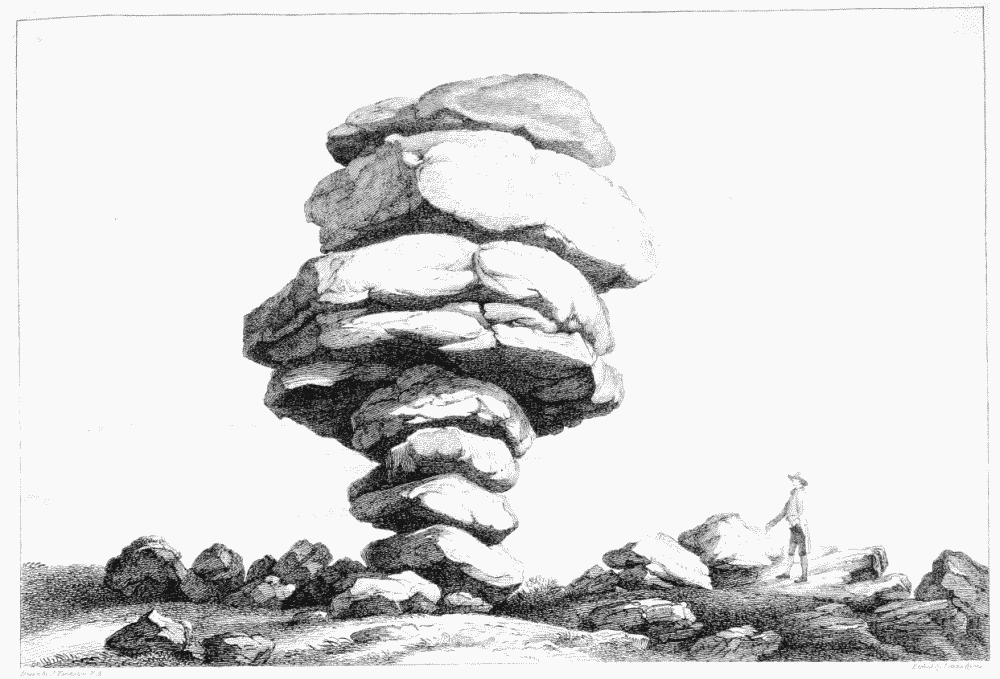
Rock called the Cheese-Wring
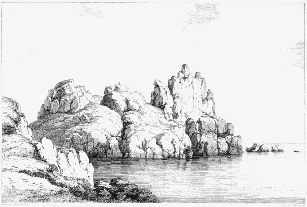
Some of the most remarkable and interesting scenery in Cornwall is that which occurs along a line of bold and abrupt coast, bounded by the Atlantic Ocean and the Bristol Channel; where, amidst a great variety of striking objects may be enumerated, the magnificent groups of granite rocks at the Land's-end, Cape Cornwall, and Castle-Treryn; the rocks of schistus at Tintagel, and the stupendous rock near Basset's Cove, with a very lofty perforation called Tabbin's Hole. The rocks of serpentine at Kynans Cove, near the Lizard Point, exhibit a great variety of picturesque forms. The inland parts of the county also present some remarkable objects in the rude masses of granite, in various fantastical forms, which appear above the surface, on the moors; many of which have been supposed in a great measure to have received their present form or situation from art; though they may be referred to natural causes, and considered as the insulated remains of stratified beds of granite-rock, which, in consequence perhaps of some inequality in their original mixture, have unequally resisted the corrosive influence of the atmosphere. The most remarkable of these are the Cheese-Wring or Wring-Cheese, a large mass of granite rock, thirty-two feet high, consisting of several layers of large dimensions, poised on others so small as to excite surprise that it should have stood for so many ages; the great stone in the tenement of Mên, in the parish of Constantine, thirty-three feet long, and 14 feet 6 inches high, of an oval form, placed on the points of two other stones, with a passage under it of about three feet wide (fn. n5); and the two logan or rocking-stones, being large masses of granite so nicely poised that they may be easily moved, one of them in the parish of St. Just (fn. n6), the other on the summit of the lofty rocks of granite called Castle-Treryn. There was a third in the parish of Sithney, called Mên-amber, which is said to have been thrown off its poise in the time of the rebellion, by order of the governor of Pendennis Castle (fn. n7). To these may be added the Kairns, and remarkable stones on Carnbré hill, which have been so often described, and termed Druidical, though their present appearance may be reasonably referred to natural causes, and attributed to the operation of time (fn. n8). Most of these granite rocks have on their surface round hollows or basins; these too have been considered, by several writers on the subject, as relicks of Druidism, though Dr. Stukeley, who was one of the first that referred all the rude monuments of the early ages to the Druids, did not go so far as to suppose the rock-basins to have been produced by them, or even by art (fn. n9); and indeed there is no reason to doubt that they have also been effected by natural means. (fn. n10)
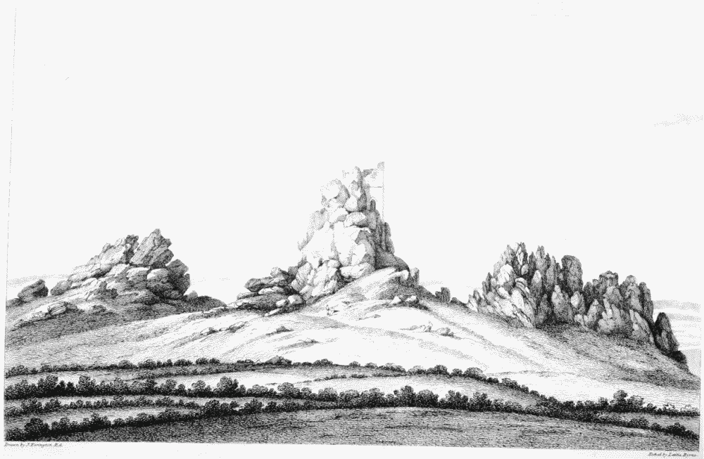
South view of Roche Rocks
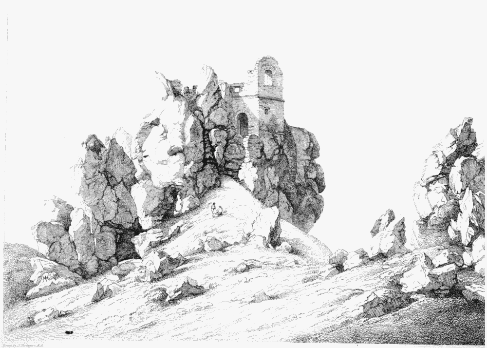
Sout-east view of Roche Rocks and hermitage
The lofty group of craggy rocks of granite, from which the neighbouring church-town of Roche takes its name, rising out of an open heath, forms as conspicuous and striking an object to the surrounding country, as the conical mount of St. Michael, near Penzance, rising immediately from the sea.
“Hils of greatest name and height,” says Carew, “are, Hinxten, Rowtor, Brownwelly, S. Agnes, Haynborough, the foure boroughs, Roche, Carnbray, and the two Castellan Danis.” He afterwards speaks of Haynborough (Henborough), which he calls the Cornish Archbeacon, as affording a most extensive view over Devonshire, and almost the whole of Cornwall, to the Land's-end. In addition to thosespoken of by Carew, Tonkin mentions Godolphin-Ball and Tregoning hill, Crowan-beacon and Carn-mark, in Gwennap; Borlase adds Carraton hill, near Liskeard. From Col. Mudge's observations, it appears that the summit of Brownwilley is considerably the highest land in Cornwall, being 1368 feet above the level of the sea, at low water; Carraton hill is 1208 feet; Kil hill, 1067 feet; Henborough, 1034; and Cadon-borough, 1011 feet.
One of the most extensive views in Cornwall is that from Henborough-down, above-mentioned: from the high grounds between North-hill and St. Cleer, the rich view over that part of Devonshire which lies between the Tamar and Dartmouth, forms a striking contrast to the dreary moors of Cornwall. (fn. n11) In the neighbourhood of Anthony are some fine views of Plymouth and Hamoaze; and from the high grounds in the hundred of Penwith some magnificent sea-views, particularly those in the neighbourhood of St. Ives, which take in Mount's bay, as well as the north sea.
Rivers. — The principal rivers of this county are the Tamar, the Lyner, the Tide or Tidi, the Seaton, the Looe, the Fawy, the Fal; the Hel or Heyl in Kirrier, the river of the same name in Penwith, and the Alan or Camel.
The Tamar rises in the parish of Morwinstow, about three miles from the north sea: passing near Whitstone, about ten miles from its source, it reaches Tamerton which takes its name from this river; at the corner of the parish of St. Stephen it receives the Werington river; and about a mile and a half further the Aterey, which runs under the walls of Launceston; at Poulston-bridge it is a wide and rapid stream; a mile below Graiston bridge it is joined by the Inney, which, rising in Alternon, passes through the parishes of Lewanick and Lezant. In the parish of Stoke-Climsland, the Tamar has a high, strong stone-bridge, called by Leland, Hawtebrig or High-bridge, now commonly Horse-bridge: the last bridge on this river is in the parish of Calstock, begun, according to Leland, by Sir Piers Edgcombe. Five miles further down, the Tamar receives the Tavy on the east, and having made a creek into the parishes of Botesfleming and Landulph on the west, becomes a spacious harbour; and after passing near the ancient borough of Saltash, is joined by the Lynher creek and river; a little further to the south it forms the noble harbour of Hamoaze, formerly called Tamarworth: having made two large creeks, one called St. John's, the other Milbrook, on the west, and Stonehouse creek on the east, (after a course of about forty miles nearly south,) the Tamar falls into the sea, having Mount-Edgcumbe for its western, and the lands of Stonehouse and St. Nicholas island, in Plymouth sound, for its eastern boundary.
The river Lynher or Lyner rises in Alterton parish, about eight miles west of Launceston, and in its course, south-south-east, passes through the parishes of Northill, Linkinhorne, and Southill, near Callington, through the park at Newton-Ferrers, by Pillaton and Lanrake, to Noddetor or Notter bridge, where it becomes navigable, and spreads into what is called Lynher creek; four miles further, continuing its course between St. Stephen's on the one side, and the parishes of Sheviock and Anthony on the other, it joins the Tamar, after a course of about 24 miles.
The river Tide or Tidi rises on the south side of Carraton-hill, near Liskeard, and, dividing the parishes of Quithiock and Menheniot, enters that of St. Germans, near Molinec; about two miles below it becomes navigable, at a place called Tidiford; two miles beyond which it passes the town of St. Germans; beyond this town it is called St. Germans creek, which being joined by Lynher creek, the two rivers proceed together and form a junction with the Tamar.
The river Seaton rises in St. Cleer, about four miles to the north-east of Liskeard, and passing within a mile of that town to a place called from it Lanseaton, runs through the parish of Menheniot, and dividing St. Germans on the east from Morval and St. Martins, falls into the sea after a course of twelve miles.
The East-Looe river rises also in the parish of St. Cleer, and having passed under Liskeard park, divides the parishes of St. Keyne and Morval from those of Liskeard and Duloe; at Sand-place it becomes navigable, and three miles from thence empties itself into the sea, after a course of ten miles, between East and West Looe. The West-Looe river rises in the parish of St. Pinnock, and passing between Lanreath and Duloe, becomes navigable at Trelawn-wear; a mile beyond which it joins the East-Looe river.
The Fawy rises in the parish of Alternon, at a place called Fawy-well, not far from Brownwilly, one of the highest hills in Cornwall. Passing between St. Neots (in which parish three bartons take their names from this river) and St. Cleer, before it arrives at Resprin bridge, in the parish of Lanhydrock, it receives some smaller streams from St. Neots, Warlegon and Cardinham; three miles beyond this bridge it reaches Lostwithiel, to which town it is navigable at high water for small vessels. About three miles further, having in the midway received the water of Pelyn brook from the west, passing between St. Sampson's and Tywardreth on the west and St. Winnow on the east, it joins Leryn creek and river (which rises between Broadoak and Lanhydrock); here it becomes a wide and deep haven: two miles further it reaches the town of Fowey, and being joined a little below by Polruan creek, falls into the sea after a course of twenty-six miles.
The Fal rises at a place called Fonton-Val, about two miles west of Roche hills. Passing near St. Dennis and St. Stephens, it becomes a considerable stream before it reaches Grampound bridge; about a mile below which it was formerly navigable for small-craft. Passing near Creed, in about three miles further it reaches the town of Tregony. An act of Parliament was passed in the year 1677, for making the Fal navigable; but it is said to have been abandoned when it had been completed nearly as far as Grampound: a mile below Tregony the waters begin to spread, and form Lamorran creek, having the parishes of Lamorran and St. MichaelPenkevil on the north, and Filleigh and Ruan-Lanihorn on the south: at the distance of three miles from Tregony it joins Maples or Mopas-Road (a body of water formed by the junction of Truro creek and St. Clement's creek): Leland mentions a naval fight which had then lately happened (in the reign of Henry VIII.) in this road, between a ship of war of Dieppe, and a fleet of eighteen Spanish merchantmen; the Frenchmen, it seems, had been chaced thither by the Spaniards. Truro creek is supplied by several streams, particularly the rivers of Kenwyn and St. Allen, which, rising in the parishes of those names, meet at the town of Truro, to which the creek is navigable at high tide for ships of small burden (fn. n12). St. Clement's creek, supplied by some streams which rise a little to the north of Ladock, is navigable for barges as far as Tresilian bridge. After the junction of Mopas-Road and Lamorran creek, the Fal, after a further course of two miles, having the village and parish of Feock on the west, reaches Falmouth harbour. This spacious haven, which in point of safety and accommodation is reckoned the second harbour of Great Britain, is four miles long, above a mile wide, and on the eastern side opposite St. Just, fourteen fathoms deep. On the west side of it are three creeks, Restronguet, Milor, and King's-Road; on the east, St. Just and St. Maudits or St. Mawes. Restronguet creek is formed by the Tretheag river, which rises between Stithians and Gwennap, the Chase-water, which rises to the north-east of St. Dye, and some other brooks; the small creek of Milor (so called from the village of that name) is supplied by a brook which rises near Enys: the great creek or harbour of King'sRoad extends from Falmouth to Penryn, two miles in length, and is navigable for ships of 100 tons burden. At the foot of Falmouth harbour the Fal opens into the ocean, between Pendennis Castle on the western bank, and St. Mawes and Anthony-Point on the east, its channel being nearly a mile wide: near the middle is a large rock, concealed at high water, on the highest part of which, to obviate its dangers, the heirs of Killigrew, formerly Lords of Arwennack, are obliged to keep a tall pole fixed.
The river Hel or Heyl, in Kirrier, rises on the hills of Wendron parish, near Penhal-Guy, about three miles above Gweek, to which place barges come up at high tide; a mile further down the Hel is joined by Mawgan creek on the south; and three miles further by Kestel or Helford creek; and at its mouth, three miles further, by Gillan creek, formed by the small river Durra, which rises between Manaccan and St. Keverne; on the north it has first Polpenwith or Polperre, and Polwhevrell creeks, running up towards Constantine church; and a mile further down Chiclow or Calamansack creek. Helford haven, within a mile of its mouth, is secure for ships of 200 tons, and at its passage into the sea is about a mile wide.
The river Lo or Low, in Kirrier, rises in the northern part of Wendron parish, about five miles above Helston; about a mile below which it forms the lake called Lo-pool.
The river Heyl or Hayle, in Penwith, is formed by the junction of four brooks, which unite at Relubbas, three miles from St. Erth bridge, where the land of Cornwall is at its narrowest dimensions, the distance being only three miles from the full sea-mark of the Heyl on the north sea, to the full sea-mark at Marazion on the south sea. From St. Erth the Heyl bears directly north, and near its mouth is joined by a brook from the east, which, under the village of Phillack, makes a branch of this haven, for ships of 100 tons: small ships only go up to the village of Lelant, on account of the sands, which have not only choaked up the harbour, but formed a bar, which causes it to be only a half-tide haven, the tide ebbing and flowing only half of its customary time. (fn. n13)
The river Conner, which gives name to the ancient manor and barton of Connarton, rises to the north-east of Crowan, passes near Camborne, and being joined by a stream from the neighbourhood of Tehidy, falls into the sea a little beyond Gwithian.
Ganal creek, which falls into the north sea near Crantock, is supplied by a stream which rises in the parish of Newlyn, near Trerice.
The river Alan or Camel rises about two miles north of the town of Camelford: after a course of about twelve miles, passing by Advent, between Michaelstow and Breward, near Blisland and Helland, it becomes navigable for sand-barges at Parbrook, and near Egloshayle is joined by the Laine, which, rising a little to the north of Lantegloss, passes near St. Teath and St. Mabyn: a mile further down, the Camel reaches the ancient bridge called Wadebridge, whither barges of sixty tons come up; a little further the river forms two small creeks on the east; and still further, two on the west, running up to St. Issey and Little Petherick: in a mile more it reaches the ancient town of Padstow, where it is a mile wide; but the navigation is much impeded by the sands. The mouth of the harbour is about two miles below the town. Further to the north there is no considerable river, but there are the creeks of Portisic or Port-Isaac, Bottreaux-castle, and Bude-haven. The mouths of all the tide-rivers on the north side of Cornwall have been nearly choaked with sand thrown up by the surge, or drifted in by the north-westerly winds.
Lakes.—The most considerable lake in this county is the Lo-Pool, between the parish of Sithney on the west, and those of Helston and Mawgan on the east. It is about two miles long, and a furlong wide, being formed by a bar of pebbles, sand and shingles, forced up against the mouth of the creek by the south-west winds. Towards the west it makes a little creek, stretching up to Penrose; and to the east another called Carminow creek, half a mile in length, and about half a furlong wide. These are the dimensions of the Lo-Pool in the summer; the superfluous water draining through the bar into the sea; but in the winter the whole valley is frequently overspread with water, from the town of Helston to the sea.
When the town-mills at St. John's bridge have their wheels stopped by the swelling of the lake, the mayor of Helston applies to the Lord of Penrose; and, on presenting him with a few half-pence in a leathern purse, has a right to cut through the bar, and make a passage for the water. So long ago as the reign of Henry VIII. it was observed by Leland, that “if this bar might be always kept open, it would be a goodly haven up to Helston.” This lake abounds with a peculiar and excellent trout, called the Lo-trout.
There is a small pool or lake of the same kind between the parish of Budock and that of Falmouth, separated from the sea by a bar of sand and shingles, formerly called Le-vine-pool, now Swan-pool. It is somewhat less than half a mile in length, and a quarter of a mile in width. The eels of this water are esteemed particularly good.
The only inland lake in this county is called Dosmery-pool, in the parish of Alternon, near the borders of St. Clere's parish, formed from a junction of the waters of the neighbouring hills. It is about a mile in circumference, and Leland describes it as fifteen fathom deep; but Mr. Carew says that, upon trial, no part of it was found deeper than nine feet, and no fish in it but eels.
Navigable Canals.—An act of Parliament was passed in 1796, for making a navigable canal (to be called the Polbrook canal) from Guinea-port, near Wadebridge, to Dunmeer-bridge, in the parish of Bodmin, and also a collateral cut to or near Ruthern-bridge in the same parish: it was proposed to have continued a communication to Lostwithiel, but it was found necessary to have a tunnel, and the undertakers were discouraged from proceeding by the great expence with which it would have been attended. Mr. Rennie was the engineer.
Dr. Borlase, in his Natural History, recommends making the Tamar navigable to Launceston, and uniting the Fawy and the Alan from Dunmeer-bridge to Resprin-bridge. “The advantages of such an union,” says he, “are too obvious to be particularized, and the difficulties too few to discourage the undertaking, whenever a public spirit for making rivers navigable shall arise in this nation. It is, indeed, to be wished, that as the eyes of all begin to see the advantage of good roads for trade and travellers, so they may in time awake and perceive the greater, at least equal, advantage of improving the water-carriage of this nation.”
In the reign of Charles I. a bill was brought in and passed the Commons, for making all the rivers in Cornwall navigable. It was brought into the House of Lords, and declared to be a noble design, which might give a pattern for all England to follow; but it being at the close of a session, the bill did not go through its stages, and the civil war soon afterwards ensuing, put an end to the design.
Roads.—The great mail-coach road from London to Falmouth, Penzance, &c. enters Cornwall at Poulston-bridge, a mile and three quarters from Launceston; after quitting that town, it passes through the villages of Hicks-mill, Five-lanes, and Trewint, over the moors of Alternon and Temple (fn. n14); through the depopulated village of Temple, by the race-ground, to Bodmin (fn. n15), which is twenty-one miles from Launceston. The church-towns of Alternon and Blisland, and the high hills of Roughtor and Brownwilly, are on the right; the church-towns of South-Petherwin, Lewannick and Cardinham, and Dosmery-pool, on the left of this road.
Quitting Bodmin, the road proceeds to Truro, twenty-two miles and a half; passing over the gorse-moors (eight miles in length), through the villages of HigherFraddon, Lower-Fraddon; Penhale and Summercourt; the small borough-town of Michell, and the village of St. Erme highway. At the two first-mentioned villages are the posting-houses of the Indian Queen and the Blue Anchor. Between Bodmin and Truro, the church-towns of St. Wenn, St. Enoder, and Newlyn lie on the right-hand; Lanivet, Roche, St. Dennis and St. Erme, on the left. The road then passes to Penryn, through the villages of Calenick, Carnon, Perran-well and Perran-wharf, leaving the church of Kea on the right, and Perran-Arwothall on the left: from Penryn along the cliff to Falmouth is two miles. The road to Penzance branches off between Truro and Penryn at the village of Perranwell, and passing near the church of Stithians, joins the turnpike-road from Penryn to Helston, six miles from the latter town. The Penryn and Helston road passes through the small villages of Polgrene, Menely, and Trelills, being a distance of ten miles: the direct road from Truro to Helston is eighteen. From Helston, the great road to the Land's-end proceeds to Marazion, ten miles, through the church-town of Breage, leaving the church-towns of Sithney and Germoe, the large village of Gold-Sithney and the church of St. Hilary, to the right; and Perran-Uthnoe to the left: it then passes along the shore to Penzance about three miles and a half, by the village of Chyandower, leaving Ludgvan and Gulval to the right, and St. Michael's-Mount, to the left. From Penzance, a carriage-road (not turnpike) proceeds to the Land's-end (eleven miles); leaving the church-towns of Maddern and Sancreet, with the populous village and church of St. Just, to the right; the great fishing-coves of Newlyn and Mousehole, the church of St. Paul, and the church-town of Burian, to the left.
The old road from the north of Cornwall to the Land's-end branched off at Michell: this road, which has been long disused for carriages, though its milestones remain, and it still keeps its place in the road-books, passed through Zealla, Redruth, and Crowless to Penzance.
The great road from London to the Land's-end, by way of Plymouth dock, enters Cornwall at Torpoint (fn. n16); three miles and a quarter beyond which it passes through Anthony church-town; two miles and a half further through Crosthole; about ten miles beyond which, having left the town of St. Germans and the village of Menheniot a small distance on the right, it reaches Liskeard: nearly twelve miles further it reaches Lostwithiel, having passed through the village of Dobwalls, over Broadoak-downs, and at no great distance from St. Pinnock, Broadoak and Boconnoc, all of which lie on the left hand: beyond Lostwithiel it leaves Lanlivery church-town a little way on the right-hand; in four miles reaches the churchtown of St. Blazey; and about four miles further the town of St. Austell: passing a little way from the church-town of St. Mewan (which lies on the right), and through the little village of Sticker, in six miles it reaches the borough-town of Grampound; and two miles and a half further passes through the church-town of Probus: two miles and a quarter beyond Probus, it passes through the little village of Tresilian; and in two miles and three-quarters from thence, leaving St. Clement's church on the left, it reaches Truro, where it joins the other great road. The turnpike-road from Launceston to Camelford and St. Columb branches off from the Bodmin road three miles out of Launceston, and leaving the churchtowns of Trewen, Laneast and St. Cleather to the left, passes through Haleworthy and Davidstow: beyond Camelford, leaving Lantegloss to the right, it passes to St. Teath (four miles), with St. Tudy and St. Mabyn on the right, and St. Kew on the left; it passes thence to Wadebridge (seven miles), in the parishes of Egloshayle and St. Breock. From Wadebridge to St. Columb, (the road not passing very near any church-town except St. Breock,) is twelve miles. From St. Columb a turnpike-road continues, about three miles, to join the great road to Truro, &c. between the Indian Queen and the Blue Anchor.
From Wadebridge there is a carriage-road, partly turnpike, through St. Issey and Little-Petherick to Padstow, fourteen miles. There is a turnpike-road also from Bodmin to Wadebridge, over Dunmeer-bridge, through the village of Slades and Egloshayle church-town, about seven miles; from Truro to Redruth, through Chasewater, leaving St. Dye a little to the left; from Redruth, between Gwennap and Stithians, to Penryn and Falmouth; from Redruth, through Camborne, and near Crowan and Sithney, to Helston, a turnpike-road branching off (from the great road from Truro to Plymouth, near Probus) to Tregony, and from thence near Veryan to St. Mawes; and from Tregony to join the Plymouth road between Grampound and St. Austell. There is a turnpike-road also from Truro to St. Agnes. It is in contemplation to make a turnpike-road from Redruth over the head of the river Heyle to Penzance, to make a nearer road from Truro to Falmouth by way of Flushing; and also to shorten and improve the road from Catchfrench to Torpoint.
From Saltash (fn. n17), one of the entrances into Cornwall, a turnpike-road passes through St. Mellion to Callington. Another road, branching off, a part of which is not turnpike, passes through Landrake and Tidiford, and joins the great road from Plymouth to Liskeard near Catchfrench.
A turnpike-road from Tavistock enters Cornwall at Newbridge (fn. n18), on the Tamar; four miles from that town, passes to Callington, leaving Calstock on the left; and thence, through St. Ive, to Liskeard (nine miles). From Callington a turnpikeroad passes to Stoke-Climsland, leaving Lezant to the left and Lawhitton to the right, to Launceston (twelve miles). Between Liskeard and Lostwithiel, on the great Plymouth road, a turnpike-road branches off, which goes by Resprin-bridge and Lanhidrock to Bodmin. There is also a carriage-road, partly turnpike, immediately from Bodmin to Lostwithiel, through the village of Maudlin, (six miles.)
There is a carriage-road, but not turnpike, from Launceston to Stratton: this road, being a distance of eighteen miles, passes through Newport and St. Stephens, leaving Werrington in Devonshire a short distance on the right, and Whitstone on the left. The road from Stratton to Camelford passes near Davidstow, where it joins the turnpike-road from Launceston to Camelford, about three miles from the latter town. This road passes through the villages of Treskinnick-cross (vulgo Skinney-cross) and Wainhouse-corner, over the high ground called Touchbarrows, leaving the village of Bude and the church-town of Poundstock to the right, and the church-towns of Marhamchurch, Otterham, and Davidstow to the left.
From Camelford, a carriage-road, not turnpike, passes to Bodmin, (twelve miles,) through the village of Penpont, and over the race-downs, leaving the church-towns of Advent, St. Breward, and Blisland on the right, and those of Michaelstow and St. Teath on the left.
The mail-coach roads are very good. The cross-roads are not much travelled. There are no post-chaises kept at Stratton, Padstow, Camelford, St. Columb, St. Ives, Looe, Fowey, Tregony, Grampound, Saltash, nor even at Callington, although two or three roads meet at that town.