A History of the County of Stafford: Volume 8. Originally published by Victoria County History, London, 1963.
This free content was digitised by double rekeying. All rights reserved.
'Longton', in A History of the County of Stafford: Volume 8, ed. J G Jenkins (London, 1963), British History Online https://www.british-history.ac.uk/vch/staffs/vol8/pp224-246 [accessed 30 April 2025].
'Longton', in A History of the County of Stafford: Volume 8. Edited by J G Jenkins (London, 1963), British History Online, accessed April 30, 2025, https://www.british-history.ac.uk/vch/staffs/vol8/pp224-246.
"Longton". A History of the County of Stafford: Volume 8. Ed. J G Jenkins (London, 1963), British History Online. Web. 30 April 2025. https://www.british-history.ac.uk/vch/staffs/vol8/pp224-246.
In this section
LONGTON
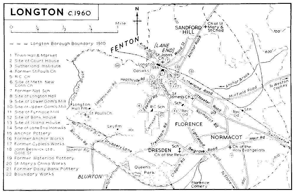
LONGTON, which lies in the south-east of the Potteries area, was a municipal borough on the formation of the county borough of Stoke-on-Trent in 1910. As incorporated in 1865 the borough of Longton consisted of the townships of Lane End and Longton (fn. 1) but was subsequently extended in 1883 and 1884 to include the areas of East Vale, taken from Caverswall parish, Normacot, taken from Stone parish, and Florence with Dresden, taken from Trentham parish. (fn. 2) The earlier history of these last three areas is reserved for treatment in later volumes, but their development as suburbs of Longton will be covered in this article.
The area covered by the townships of Lane End and Longton was roughly 1,000 acres (fn. 3) and consisted of three tongues of land radiating from the town of Longton. The largest tongue, about a mile wide and tapering to roughly 440 yards at its southwesterly point, stretched westwards for 3 miles south of Fenton to the Chitlings Brook just beyond the present railway line from Stoke to London. The other two extended north and east; the northerly tongue, just over ½ mile in width, ran for a mile on both sides of the road to Adderley Green and Caverswall, the natural boundary on the east being the Cockster Brook, and the easterly tongue, ¼ mile in width, extended for a mile and a half on both sides of the road to Uttoxeter. (fn. 4)
The area, which lies on the edge of the moorlands, is one of low but steep hills and is cut by two valleys. The land drops from an escarpment in the north, called Sandford Hill, to the larger of these valleys, about ½ mile in width. The country rises again on the south to about 450 ft. at Swingle Hill. (fn. 5) The second and lesser valley divides this hill from the high ground in the west of the area. (fn. 6) The Anchor Brook which rises in the grounds of Park Hall in Caverswall parish flows through the larger of the two valleys, although it is now largely built over. West of the town centre it is joined by a small tributary which flows down from the Golden Hill part of Fenton and formed the boundary between Longton and Fenton in that area. The Anchor Brook then changes its name to the Cockster Brook which likewise formed the boundary between Longton and Fenton as far as the point where it turns south to flow through the second valley. (fn. 7) A third brook, the Furnace Brook, was described c. 1840 as rising 'from several powerful springs in the hamlet of Normicot which gush from under the sandstone formation of Meir Heath', (fn. 8) and at that date it formed extensive ornamental pools at the edge of the Longton Hall grounds. (fn. 9) Now only a sluggish stream, it flows west for some way and joins the Cockster Brook east of Longton Hall. Here the two form the Longton Brook which flows west along the former southwestern boundary of Longton township into Trentham parish.
The wider of the two valleys is the route of a Roman road from Derby (fn. 10) and has long been one of the main ways of access into North Staffordshire from Derbyshire. It was on this road, roughly at the point where the Anchor Brook and the stream from Goldenhill meet, that the hamlet of Lane End or Meare Lane End grew up in the late 17th century (fn. 11) under the influence of coal and ironstone mining and ironworking. (fn. 12) In 1666 13 houses in Longton were chargeable to Hearth Tax and 12 in Meare Lane End. (fn. 13) Meare Lane End was mentioned c. 1680 by Gregory King who noted that there were 5 or 6 houses in Longton itself. (fn. 14) Tracks led south-eastward from Meare Lane End to Stone and northward over Sandford Hill to Hanley, Adderley Green, Leek, and the north-east of the county by the 18th century. (fn. 15) The turnpiking of the Newcastle to Uttoxeter road under an Act of 1759, of the road to Stone under an Act of 1771, and of the road to Adderley Green under an Act of 1813 greatly facilitated the growth of Lane End. (fn. 16) By 1775 there was a nucleus of houses at the junction of the roads and for a short distance along these three roads and along the road to Longton Hall which joined the Stone road just south of the centre of the village. There were in addition a number of scattered houses and numerous coal pits between the Uttoxeter road (then called Meer Lane) and the Stone road. (fn. 17) In 1784 Lane End was still small enough to be called a village, (fn. 18) although it was fast developing as a community. The first school was built c. 1763 (fn. 19) and the first church in 1762, (fn. 20) and in 1789 the market-square (now Times Square) was laid out at the junction of the Uttoxeter and the Stone roads. (fn. 21) By the end of the century there was a network of streets in the centre of the town forming a built-up area bounded by Market Lane (now Transport Lane), the Stone road, the Uttoxeter road, and Commerce Street; the streets in this central area are now called Cornhill Passage, St. Martin's Lane, Cyples Lane, Kingcross Street, and Chancery Lane. By then, also, both sides of the Uttoxeter road had been built up for about half a mile from the town centre. (fn. 22) In 1794 a second market-square (later Union Square) was laid out at the north end of Commerce Street. (fn. 23)
The fine stipple indicates built-up areas.
In the early 19th century Lane End was noted 'for the great irregularity in the position of its buildings of every size and sort from the respectable residence of the manufacturer to the mud and saggar hovel of the pauper scattered over a wide extent of territory'. (fn. 24) In the late 1830's the name of the town was changed in popular usage from Lane End to Longton, 'the name "Lane End" being rather offensive to modern ears polite, as conveying an idea of meanness which no longer answered to the respectability of the place'. (fn. 25) It was not officially altered until 1848 after the inhabitants had in that year petitioned that the name should be altered to Longton for postal and governmental purposes since the name had frequently been used to denote the town in official documents (fn. 26)
During the century considerable changes took place in the centre of the town. Times Square had been enlarged by 1832, (fn. 27) and was altered further when the new market and town hall was erected in 1844 extending back to Market Lane (now Transport Lane); it was again altered in 1863 when the present town hall and covered market were built extending back to Market Lane and also west to Stafford Street (now The Strand). (fn. 28) In 1832, also, there was a square known as Dragon Square at the junction of the present Cyples Lane, Kingcross Street, and Chancery Lane. (fn. 29) This had been partially built over on the Chancery Lane side by 1865 (fn. 30) and had become merely a road junction by the late 1870's. (fn. 31) In 1941 the buildings in the area behind the town hall and market as far back as Kingcross Street were demolished and the ground used for a bus station. (fn. 32) The railway station, just west of Times Square, was built in 1848, (fn. 33) the line crossing the north end of the square on an iron viaduct. No other major alterations to the layout of the centre of Longton have taken place, although most of the individual buildings in the area were replaced in the later 19th century.
With the rapid expansion of the pottery, coal, and iron industries, early in the 19th century, the town grew quickly. In the area between the town centre and the eastern boundary streets were laid out connecting the Uttoxeter road and the Stone road. Buildings erected along them, though still intermittent and mainly in the Uttoxeter road area c. 1820, (fn. 34) had by 1832 become more concentrated. (fn. 35) By c. 1865 the area between High Street (the Uttoxeter road, formerly known as Meer Lane) and the stretch of Furnace Road, now known as Normacot Road, had been solidly built up with pottery works and terraced housing as far east as Lovatt (now Calverley) Street. (fn. 36) The area between Furnace Road and the southern boundary of the borough was also by this time solidly built up with terraced housing, except for brick-fields and works. (fn. 37) By the late 1870's the brick-works opposite St. James's churchyard had been replaced by terraced houses. (fn. 38) There were, by c. 1865, allotments south of Furnace Road adjoining the eastern boundary of the borough (fn. 39) and these still existed in the late 1870's. (fn. 40) The area known as Mount Pleasant, around the present Lawley Street, had also been built up with terraced cottages and potworks by c. 1865. (fn. 41) The cottage hospital and Mount Pleasant mission church were established in Mount Pleasant by 1868. (fn. 42) In the present century there has been much demolition in this area, partly in consequence of an underground fire c. 1916, which made many of the houses unsafe, (fn. 43) and also for the extension of the factory of Ridgway Potteries Ltd., built on part of the land c. 1944. (fn. 44)
East Vale, lying north of the North Staffordshire railway line and east of the Adderley Green road, had been built up with terraced cottages around Goddard and Ford Streets by the late 1870's. (fn. 45) By this date streets had been laid out in building plots north and east of this area (fn. 46) but these have not been built on.
To the south of Longton, development took place in the later 19th century in the areas known as Florence, Dresden, and Normacot. The area to which the name Florence was given, (fn. 47) extending from the Uttoxeter road to Trentham road and belonging to the Duke of Sutherland, was laid out in building plots by 1867. (fn. 48) By the late 1870's the southern part of this piece of land, including Kildare, Blantyre, Howard, Ronald, and Leveson Streets, was built up as far as Leveson Street with terraced houses (fn. 49) with the exception of Trentham Road where larger detached and semi-detached houses had been built, some before 1867. (fn. 50) By 1898 the northern part of Florence had also been built up. (fn. 51)
The district to which the name Dresden was given, lying south of Longton borough and south of the road from Normacot to Trentham, was developed by the Longton Building Society (fn. 52) by the late 1870's. (fn. 53) Most of the streets consist of terraced houses but in Cocknage Road larger detached and semi-detached houses were built. In the area between Park Avenue and the borough boundary, Queen's Park, consisting of 45 acres, (fn. 54) given by the Duke of Sutherland to commemorate Queen Victoria's Jubilee, (fn. 55) was laid out in 1887 and opened the following year. (fn. 56)
Normacot, comprising the triangle of land between the Uttoxeter road, Upper Normacot Road, and Meir Road, lying east of Longton, had been laid out in building plots for the Duke of Sutherland by 1875 (fn. 57) and much of it built up by the late 1870's. (fn. 58) Further houses had been built by 1898. (fn. 59) Land between Normacot and Florence was also laid out in building plots for the Duke of Sutherland in 1864, (fn. 60) but the building plan was not carried out for some years, the eastern end of the area being built up in the last quarter of the century. (fn. 61)
The Greendock area south-west of the town was already developing c. 1820, probably because of its proximity to collieries, along the present Heathcote Road, Edensor Road, and Greendock Street. (fn. 62) This development had become more concentrated by 1832. (fn. 63) Farther south, houses had also been built by 1820 at Daisy Bank, where a pottery works had been established in the late 1770's. (fn. 64) More building took place in the Edensor area between Heathcote and Trentham Roads between 1832 and c. 1865, and also farther east at Daisy Bank where more pottery works and a brick-works had also been established. North of Heathcote Road rows of terraced cottages were built in this period along the line of Marsh Street (now Griffin Street) and Gregory Street running between Heathcote and Foley Roads and around Weston Place at the junction of these two roads. (fn. 65) Further streets of terraced cottages had been built by the late 1870's in the area around Gregory Street and Marsh Street. (fn. 66) Considerable demolition of houses has taken place in recent years and the terraced cottages in the Greendock area are gradually being pulled down and replaced by small terraces of council houses.
North of the town there was some building along the line of the new road to Adderley Green by 1832 but this was still concentrated along the old road (Wood Street) and also along Caroline Street, which runs parallel to and east of Wood Street. (fn. 67) The main road from Uttoxeter to Stoke was built up by 1832 as far as the Fenton boundary. (fn. 68) Between 1832 and c. 1865 new building took place in the Ashground mining area to the north of the road. Ashwood, joining Wood Street by the parsonage, was laid out; detached houses with gardens were built on its south side at the east end and terraced houses on the north side at its west end. Farther north and running off the Adderley Green road (now Anchor Road) in a westerly direction Albert Street, Edgefield Road, and Heathcote Street had been laid out, but no houses had been built there. (fn. 69) Just south of these, east of and parallel to the Adderley Green road, Pitt Street (now Walpole Street) and Lord Street (now Bartlem Street) had also been laid out but not built up. All these streets had been partially built up with terraced houses by 1879. (fn. 70) In Wood Street prefabricated houses were erected on cleared areas after the Second World War.
In 1666 there were 13 persons in Longton and 12 in Lane End chargeable to Hearth Tax. (fn. 71) In 1811 the population was 4,930 (fn. 72) and during the 19th century the population figures show a continued rise: 1821, 7,100; (fn. 73) 1851, 15,149; (fn. 74) 1871, 19,748. (fn. 75) In 1891 the figure was 34,327, which included the added areas of East Vale, Dresden, Florence, and part of Normacot. (fn. 76) In 1901 the population of the borough was 38,815. (fn. 77) The population of the same area in 1911 was 37,479, (fn. 78) and in 1921, 37,812. (fn. 79)
Of the three roads at the junction of which Longton developed, at least two are ancient routes. The road running through Longton from Uttoxeter was used during the Roman occupation. (fn. 80) It was probably used continuously thereafter, occurring again as a highway in 13th-century records. (fn. 81) It was turnpiked under an Act of 1759. (fn. 82) It was disturnpiked in 1875 and declared a highway and a county responsibility under the Highways and Locomotives (Amendment) Act of 1878. (fn. 83) The road to Stone occurs in the early 13th century. (fn. 84) This was turnpiked under an Act of 1771. (fn. 85) The road to Adderley Green followed the course of Wood Street originally. Under an Act of 1813 a new turnpike road to Adderley Green, the present Anchor Road, was built. (fn. 86) This road was disturnpiked in 1877 (fn. 87) and declared a main road under the Highways and Locomotives Act of 1878. The road from Fenton to Blurton, turnpiked in 1778, was also disturnpiked in 1877 and made a main road under the 1878 Act. (fn. 88) The road from Meir to Trentham, turnpiked in 1771, runs across the southern part of Longton. (fn. 89) Three other roads in the borough, not previously turnpiked roads, were declared main roads and a county responsibility under the 1878 Act: the road from the town centre past Longton Hall which was said to be the most direct route to Heron Cross and Fenton from Longton; the road to Normacot, otherwise known as Furnace Road; and Sutherland Road, the most direct road from Longton to Wetley, Cheddleton, and Leek. (fn. 90)
By 1834 four coaches ran through Longton. Three ran daily from the Eagle Inn between Liverpool and London, Burslem and Birmingham, and Longton and Manchester, while the Newcastle to Derby coach ran three times a week stopping at the Crown and Anchor Inn. (fn. 91) By 1824 Longton was on the route of a local service between Hanley, Stafford, and Birmingham, (fn. 92) and by the middle of the century there was an omnibus service to Hanley and Burslem. (fn. 93) In 1881 the North Staffordshire Tramway Company opened a line from Stoke to Longton market-square. (fn. 94) A controlling interest in the company was acquired by the British Electric Traction Company (later the Potteries Electric Traction Company) which electrified and extended the lines within the borough between 1899 and 1905. (fn. 95) As in other parts of the Potteries, buses began to operate from 1914, and between 1926 and 1928 replaced the tramway service. (fn. 96)
By 1790 Longton had its own postmaster. (fn. 97) The town was served by a horse-post and a foot-post from Newcastle from 1835 until the establishment of the head post-office for the Potteries at Stoke in 1854. (fn. 98)
A railway line extending from the Trent and Mersey Canal near Stoke to Longton had been built to carry goods by 1832. It was still in use in the late 1870's. (fn. 99) On the construction of the North Staffordshire Railway's line from Stoke to Uttoxeter and Burton in 1848, a station was opened at Longton. (fn. 100) An omnibus ran twice daily from the station and the Union Hotel to Hanley and Burslem by 1851 (fn. 101) and to Stoke by 1854. (fn. 102) This service continued until at least 1860. (fn. 103) Normacot Station was opened in 1882. (fn. 104) In 1875 a single-track mineral line was opened by the North Staffordshire Railway from this line at Millfield Junction through Adderley Green to the line from Stoke to Biddulph and Leek south-west of Bucknall. It became a light railway for passenger traffic early in the 20th century but by the mid1920's was once more a mineral line only. (fn. 105) It is now broken into two unconnected parts near Adderley Green. By the late 1870's a mineral line had been built from the Florence Colliery, opened c. 1875, to the main line south from Stoke near Trentham. (fn. 106)
Buildings
There are now few buildings in Longton, other than early pottery works, which date from before the middle of the 19th century. Longton Court House, earlier known as the Union Market Hall or the Old Town Hall, survived until 1950. (fn. 107) It was built, apparently in 1814, on land at the junction of Market Street and Commerce Street, and was originally 'a handsome brick structure supported by an arched basement'. (fn. 108) At the time of its demolition in 1950 it was a two-storied building with a front of five bays, having a central Venetian window beneath a small pediment. The ground floor arches had been filled in and the walls faced with stucco, (fn. 109) alterations dating probably from 1856. The site is now occupied by a small public garden. The present town hall and market, fronting upon Times Square, replaced an earlier building in 1863 (fn. 110) when the site was extended to include all the ground between Times (formerly Market) Square, Transport (formerly Market) Lane, and The Strand (formerly Stafford Street). (fn. 111) Facing Times Square the Town Hall has a long two-storied front of blackened stone incorporating Classical features. The ground floor, which includes a central projecting portico of three bays, is occupied by part of the market; the upper story has blind openings decorated with carved panels and in the centre are Ionic pilasters surmounted by an entablature and pediment. The single-story covered market, which has suffered considerably from subsidence, occupies the rest of the large site behind the town hall and has stone façades in which arched entrances and shop fronts are incorporated. The Sutherland Institute in Lightwood Road (formerly Stone Road), erected in 1897–9 and designed by Wood and Hutchings of Tunstall and Burslem, (fn. 112) is a large red brick building, its principal front carrying a continuous terracotta frieze illustrating the pottery industry.
The former National school, built in 1822, (fn. 113) is a single-story brick building still standing in St. John's churchyard. The front has hood-moulds to the windows and a central gable below which is a dated tablet. Twin doorways with moulded brick jambs and pointed heads give access to separate schoolrooms for boys and girls. Adjoining it on the south side and carrying a date tablet of 1829 is the infants' school, a replica in miniature of the 1822 building.
All the larger dwelling houses in the town dating from before Victorian times had disappeared by 1960. These included the Woodhouse, Island House, and St. John's Parsonage, all well to the north of the town-centre, and Bank House, lying immediately north of Church Street near the Fenton boundary. (fn. 114)
Until its demolition in 1939 the most important house in the area was Longton Hall, standing on rising ground two miles south-west of the town and overlooking the Furnace Brook. There was possibly a manor-house at Longton in the Middle Ages and certainly one by the early 17th century. (fn. 115) It may have been rebuilt on its present site by the Lane family after they had obtained a lease of the manor in 1702, but Longton Hall as it survived into the 20th century probably owed more to alterations carried out by John Edensor Heathcote about 1778. (fn. 116) He is known to have been planning extensive repairs in 1777 when he was employing a 'Mr. Gardner' as architect and was proposing to install a Wedgwood fireplace. (fn. 117) The architectural features of the exterior, as shown by surviving drawings and photographs, suggest a building largely remodelled about this time. (fn. 118) The house was of three stories and approximately square on plan with a wing extending to the north. On the south side were two projecting bays, rising to the full height of the house, while the west front was adorned with Ionic pilasters, an enriched frieze, and a central pediment.
A large block of stables and other outhouses is still in existence to the north-east of the former house. These may have been begun when the Lane family moved back to the hall in the 1760's, (fn. 119) but more probably originated with John Edensor Heathcote later in the 18th century. The Longton Hall porcelain manufactory is thought to have occupied the same site, the kilns standing at the south-west angle of the later stable block. (fn. 120) It is likely, therefore, that any buildings connected with the works had disappeared by the end of the 18th century, if not earlier. The existing outbuildings are of red brick and are mainly of two stories; they are arranged round three sides of a rectangular courtyard, its northern end closed by a screen wall having at its centre a water trough in an arched recess. Beyond the wall stands a separate cottage block with a central gable. It would appear that the south range, which has pedimented doorways on its south front and at one time contained a laundry and a brewhouse, was the first to be built. The outer wall of the west range is apparently contemporary, (fn. 121) but at some later date—probably between 1824 and 1827 when Richard Edensor Heathcote spent over £5,000 on additional buildings at Longton Hall—the west range was remodelled. (fn. 122) Work carried out at the same time seems to have included the levelling of the courtyard, which had formerly sloped towards the south, (fn. 123) as well as the erection of the east range and of the cottage block. Richard Heathcote also built the west lodge, a single-story stucco-faced cottage which still stands, and laid out the gardens. (fn. 124) A carriageway ran from the lodge through parkland in front of the hall and then in a wide sweep past an ornamental pool and through an Italian garden to the stables. The house was connected to the south-west angle of the stable block by an arcaded wall. Alterations and additions made between 1850 and 1865 included the screen wall at the north end of the stable court, a small coach-house at the south end, and probably an icehouse lying to the south of the other outbuildings. (fn. 125)
Longton Hall Lane Farm, lying on the north side of the road opposite Longton Hall stables, is an early-19th-century brick house with outbuildings of the same period. To the west is a cottage probably dating from the early 17th century, now surrounded by modern bungalows. It has been altered and partly brick-faced but one timber-framed wall remains exposed. The only other timber-framed building in the area appears to be Ley Farm which overlooks the Furnace Brook about 500 yards south-east of the Longton Hall site. (fn. 126) The house is T-shaped on plan with the upper rooms, lighted by dormer windows, occupying part of the roof space; the walls are faced with later brickwork and roughcast externally.
At the beginning of the 19th century Lane End (later known as Longton) appears to have been a settlement of irregular layout, covering a wide area but with many scattered houses serving individual potworks, ironstone mines, and coal pits. As the century proceeded the town became more solidly built-up and the earlier courts and terraces, hemmed in by later streets, (fn. 127) soon degenerated into slums. In the Edensor district, in John Street (now Calvin Street), in Locketts Lane, and in the area round St. James's Church conditions in the later 19th century were probably as bad as anywhere in the Potteries. (fn. 128) Even after the Second World War a square of thirteen houses at the junction of Normacot Road and Chelson Street was served by only one tap and one water-closet. (fn. 129) Two early-19th-century terraces which are still standing on the steeply sloping ground at Millfield, between Uttoxeter Road and Sutherland Road, probably represent some of the better housing of that period. These are built on the 'cottage' plan (fn. 130) with two rooms to each floor; back wings, where they exist, appear to be later additions. By 1960 nearly all the poorer housing in Longton had been demolished and the sites were either vacant or, as in the Edensor area, had been used for new streets of council houses.
Manor
In 1212 an estate in Longton was held in chief in socage by Ranulph de Bevill at a rent of 5s. in succession to his father Ranulph. (fn. 131) By 1236 this estate had become part of Newcastle manor, and 40 days' castle-guard service had been added to the obligations of the tenant. (fn. 132) Between this date and 1250 a carucate and a virgate out of the estate had been alienated to 7 tenants, and in 1250 William de Bevill, Ranulph's son, granted 3 acres of arable, 1 acre of meadow, and the service due from Longton mill to Trentham Priory. (fn. 133) William, however, continued to owe the same service as though no alienation had taken place and in addition paid 9s. 8d. for the part alienated to laymen. Trentham Priory paid 2s. direct to the king for its share. (fn. 134) The estate which William retained is first described as the manor of LONGTON in the mid-13th century, (fn. 135) and the overlordship remained with the manor of Newcastle until at least 1650. (fn. 136)
By 1272 William had been succeeded by his son Robert de Bevill (fn. 137) who by 1292 was dead, a Ralph de Bevill holding Longton in that year. (fn. 138) Ralph had been succeeded by 1297 by a Roger de Bagenholt. (fn. 139) Nothing further is known of the manor of Longton until 1591 when a John Hunt held an estate here. (fn. 140) At his death in 1600 the estate included a messuage and croft called the 'Hallecroft'. (fn. 141) John was succeeded by a son Thomas, then a minor. (fn. 142) In 1649 Thomas, described as an 'ironmonger', was declared bankrupt (fn. 143) and the manor of Longton was sold by the Bankruptcy Commissioners in 1650 (fn. 144) to William Bedwell of 'Feevering' (? Feering), Essex, who in 1651 sold it to Richard Foley of Birmingham, also an ironmaster. (fn. 145) The latter died without issue c. 1680 and by will devised the manor of Longton to his uncle, John Foley of London. (fn. 146) John Foley died before 1690 (fn. 147) and left the estate to Thomas Foley of Witley Court, Worcs., created Baron Foley of Kidderminster in 1712. The manor descended in the Foley family (fn. 148) until 1773 when it was sold to the Revd. Obadiah Lane, then lessee of the manor. (fn. 149)
In 1702 Lord Foley leased the manor to Obadiah Lane of Normacot Grange for 99 years or three lives. (fn. 150) Obadiah had been succeeded by 1709 by his son Nathaniel Lane (fn. 151) and he in 1720 by his son, the Revd. Obadiah Lane. (fn. 152) Obadiah Lane was living at the hall in July 1749. (fn. 153) He was still describing himself as of Longton in January 1752 (fn. 154) but by August of that year had moved to Birmingham. (fn. 155) A porcelain works had, however, been established at the hall by 1749 or 1750 and continued until 1760. (fn. 156) Obadiah died in 1757, (fn. 157) and his son Obadiah acquired a new lease of the manor in 1758, (fn. 158) the year in which he became curate of Blurton in the adjoining parish of Trentham. (fn. 159) It is highly probable that after his father's death this Obadiah Lane was trying to resume possession of the hall (fn. 160) but the Lane family was not again living at the hall until the 1760's. (fn. 161) Obadiah Lane resigned the curacy of Blurton in 1772 (fn. 162) and leased the hall in the same year to Thomas Griffin on an eleven-year lease determinable at the end of five years if the estate were sold. (fn. 163)
Lane bought the manor in 1773 (fn. 164) and put the whole estate up for sale in 1774 or 1775. (fn. 165) The hall was sold with other lands c. 1775 to Thomas Fletcher, (fn. 166) who sold the hall itself to John Edensor Heathcote in 1778. (fn. 167) A year later Obadiah Lane died and the manor was sold in 1784 by the trustees under his will to Sir John Edensor Heathcote, (fn. 168) who had already purchased estates in Longton. (fn. 169) The manor has since descended in the Heathcote family, (fn. 170) passing on the death of Sir John Edensor Heathcote in 1822 to his eldest son, Richard Edensor Heathcote, (fn. 171) who died in 1850 and was succeeded by John Edensor Heathcote. (fn. 172) This John Edensor Heathcote left the estate on his death in 1869 to his sister's son Justinian Heathcote Edwards who took the surname Heathcote in 1870. (fn. 173) He died in 1928 and the estate was then broken up. (fn. 174) The Heathcote family had ceased to live at Longton Hall c. 1840. (fn. 175) In 1847 Richard Edensor Heathcote leased the hall for 21 years to Charles Harvey, (fn. 176) a banker of Longton. (fn. 177) Harvey sub-let it in 1853 to Henry Wileman, (fn. 178) and in 1868 a J. E. Davis was living there. (fn. 179) In 1870 Justinian Heathcote Edwards Heathcote agreed to lease the hall to John Balguy; (fn. 180) in 1872 he leased it to John Hackett Goddard for fourteen years. (fn. 181) After J. H. E. Heathcote's death in 1928 the hall was sold by his executors in 1933 to Messrs. J. and F. Wotton of Bloxwich. (fn. 182) It was demolished in 1939, (fn. 183) except for the stables and cottages which, with the site, are still owned by Messrs. J. and F. Wotton. (fn. 184)
Courts baron were being held for the manor of Longton in the 18th century, the court in December 1758 being held at the Anchor House. The boundaries of the manor were perambulated at the courts of November 1751 and December 1758. (fn. 185)
Other Estates
The Anchor House, mentioned in 1758, (fn. 186) was probably situated on the land lying north-east of the centre of Longton called the Anchor Ground, which was held in 1778 by Richard Myatt. (fn. 187) In that year the land, and presumably the house, were bought by John Edensor Heathcote. (fn. 188) By at least 1834 Anchor House was the home of John Carey, a potter. (fn. 189) By mid-century it had been surrounded by a moat and was known as The Moat, being then occupied by Moses Cartwright, (fn. 190) as tenant of Harriet Rammage, widow of John Carey. The Heathcote family still owned at least part of the Anchor Ground in 1851. (fn. 191) The moat surrounding the house, which by the late 1870's was called Island House, (fn. 192) had been drained by the early 1920's. (fn. 193) The house has since been demolished.
An estate south-west of Longton Hall and later centring on the mill known as Gom's Mill, can be traced back to 1595 when a Thomas 'Bagnald' was dealing by fine with 2 messuages and various lands in Longton. (fn. 194) The Bagnalls still held the estate in 1601. (fn. 195) The mill, which had formerly been occupied by Thomas Caldwell, was leased by Joyce Bagnall of Barlaston and her son Randle with some fields in 1632 to Sampson Gomm and his wife Elizabeth for a term of two lives. (fn. 196) It was subsequently occupied by an Andrew Stringer and by 1667 was tenanted by Gabriel Clarke, when it was settled, along with a house and lands occupied by Ralph Hattons, by its owner Thomas Proctor of Barlaston as the jointure of the wife of his son John. (fn. 197) This estate had passed to John Proctor by 1700, by which date the house formerly tenanted by Ralph Hattons had passed through the tenancy of Thomas Bagnall and was then held by his son, James Bagnall, (fn. 198) who still held it in 1728. (fn. 199) In 1732 the whole estate, then described as 'two capital messuages known as Gom's Mill and The Fish', was sold by Thomas Proctor, who had succeeded his father John Proctor, to John Peate, a potter of Lane Delph. In addition to the two houses, it consisted of a water corn-mill and a smithy and various lands. (fn. 200) There were three tenants of the estate, one of whom was still James Bagnall; the others were John Till and William Brough. (fn. 201) By 1745 a kiln had been built at Gom's Mill but the smithy had ceased to be used. There were fourteen fields attached to the mill, and the mill and kiln were apparently being worked by Peate and James Bagnall while the two houses were tenanted by Thomas Elkin and Roger Dale. (fn. 202) The estate was sold in 1748 to a Thomas Cotton by the creditors of John Peate. (fn. 203) Cotton was acting on behalf of an ironworks partnership but died before executing a conveyance to the partners. Soon afterwards Cotton's son Thomas conveyed the estate to Richard Edward Hall, William Bridge, Anna Kendall, Jonathan Kendall, Samuel Hopkins, and John Smith. (fn. 204)
In 1765 a Samuel Hughes purchased the equity of redemption of the mortgage on Gom's Mill (fn. 205) and the estate is subsequently found in his hands. (fn. 206) Hughes, described as a miller, sold the estate, including a corn mill, to John Edensor Heathcote in 1778 but apparently retained some interest in it until his death in 1796, (fn. 207) when he left the Gom's Mill estate to his wife, Mary. Her will, leaving Gom's Mill jointly to her sons Peter and Thomas Hughes, was proved in 1804. (fn. 208) By 1808 the property had been acquired by Sir John Edensor Heathcote. (fn. 209) A second mill had been erected at Gom's Mill by then, (fn. 210) and by 1823 both were tenanted by Booth, Dale, and Deakin, on an annual tenancy. (fn. 211) By 1851 both mills, then used for flint grinding, were tenanted by Sampson Bridgwood. (fn. 212) In 1867 John Edensor Heathcote leased the Upper and Lower Mills, along with Longton Old Mill, to James and Alfred Glover for 32 years. (fn. 213) By 1892 the residue of this lease had been vested in the Longton Hall Company, but the Lower Mill had possibly ceased to be used by this date. (fn. 214) By 1930 both mills had been closed and the site of Lower Gom's Mill, then occupied by George Breward under the terms of a lease made in 1913, was sold by the executors of Justinian Heathcote Edwards Heathcote to Arthur Adams, described as of Gom's Mill, presumably the Upper Mill. (fn. 215)
The two mill pools, that of Lower Gom's Mill lying west of Upper Gom's Mill, were situated on the south-east side of Gom's Mill Road, just north of the present football ground and opposite Ley Farm. They were partly dry by the late 1870's (fn. 216) and have now disappeared. The mill buildings have also disappeared, except for a cottage and outbuildings on the site of Upper Gom's Mill. The mill-race is now a slow stream.
The farming land attached to Gom's Mill appears to have been detached from the mill after the sale to the Heathcote family. The capital messuage, formerly known as The Fish, was presumably on or near the site of the present Ley Farm, which, with 51 acres of land, in 1851 was tenanted by James Rae. (fn. 217) By the late 1870's it was known as Gom's Mill Cottage, but again as Ley Farm by 1898. (fn. 218) In 1928 Ley Farm was sold by the executors under the will of J. H. E. Heathcote to Mrs. Elizabeth Ellen Ray, (fn. 219) and in the late 1950's was still in the hands of the Ray family. (fn. 220)
In 1250 William de Bevill, then lord of Longton, granted 3 acres of arable land and 1 acre of meadow in Longton and the service due from the mill to the priory of Trentham. (fn. 221) In 1251 the priory of Trentham owed 2s. a year for its lands in Longton to the king's manor of Newcastle. (fn. 222) Further grants were made by Sybil widow of William de Bevill (fn. 223) and in 1272 by Margery widow of Ranulph de Bevill. (fn. 224) By 1291 the priory's lands in Longton consisted of a carucate worth 10s. (fn. 225) At its dissolution in 1537 the priory held in Longton two farms, one let to Ralph Machin and the other to Margery Bolton and her son John. To the second farm there belonged two pastures called Priors Field. (fn. 226) In 1538 the lands of the priory, including land at Longton, were granted by the Crown to Charles Duke of Suffolk (fn. 227) and subsequently in the same year he was given licence to alienate them to Thomas Pope. (fn. 228) In 1540 Sir Thomas Pope was licensed to alienate these lands to James Leveson (fn. 229) in whose family they subsequently descended. (fn. 230) In 1730 the possessions of John Lord Gower included the area known as the Priors Field, (fn. 231) lying immediately north-east of the centre of the present town, (fn. 232) and two farms, Nicholls' farm and Boulton's farm, both held by John Boulton. (fn. 233) In 1783 Lord Gower exchanged a farm in Longton, occupied by John Ford, with John Edensor Heathcote for Hollybush farm lying to the west of Longton. (fn. 234) By 1813 further lands totalling 110 acres had been added to the Hollybush estate, (fn. 235) presumably as part of the Marquess of Stafford's policy of consolidating and enlarging farms. (fn. 236) The farm, which by then had an acreage of 175 acres, (fn. 237) was in that year exchanged with Sir John Edensor Heathcote (for lands outside Longton), presumably again as part of the marquess's policy of consolidating his estates. (fn. 238)
The Woodhouse, which lay north of Longton to the east of what is now the junction of Anchor Road and Wood Street, occurs in 1649 when it was sold by Thomas Bagnall and Richard Heath of Newcastleunder-Lyme and John Heath of Clavering (Essex) to Henry Goringe of Kingstone parish and Thomas Lovatt of Callowhill in the same parish. (fn. 239) In 1652 Simon Degge of Callowhill, William Farmer of Stafford, and Christopher Smyth of Callowhill conveyed it to Alexander Howe of Caverswall. (fn. 240) Alexander Howe's daughter and coheir, Sarah, married the Revd. George Newton, (fn. 241) who was dealing with the Woodhouse by fine in 1686 (fn. 242) and settled it on his daughters and coheirs Alice and Elizabeth Newton in 1714. (fn. 243) It was sold by the Newtons in 1716 to Richard Hulme of Adderley Green and Thomas Baggaley of Longton. (fn. 244) Hulme leased his half immediately to Baggaley for ten years. (fn. 245) This moiety was again leased to Baggaley in 1719. (fn. 246) In 1729 Thomas Baggaley leased the Woodhouse to Thomas Boulton for 99 years or three lives. (fn. 247) Richard Hulme leased his moiety of the Woodhouse to Thomas Boulton in 1743 for 21 years. (fn. 248) By 1774 William Boulton had acquired the freehold of the Woodhouse (fn. 249) which was sold by the trustees under his will (fn. 250) in 1808 to Sir John Edensor Heathcote. (fn. 251) The Heathcote family still owned the Woodhouse in the early 1850's (fn. 252) when it was occupied by John Wardle. (fn. 253)
Churches
Longton and Lane End both lay within the parish of Stoke until the 19th century (fn. 254) but by the later 18th century some provision was being made for Anglican worship. A small church was built in 1762, the cost being defrayed by public contributions, the major part of which came from John Bourne of Newcastle. (fn. 255) Its position in the Church of England was at first anomalous. Although it was used for Church of England services, (fn. 256) it was registered in 1762 as a chapel for Protestant Dissenters, (fn. 257) a device adopted presumably in order to legalize its status as a place of worship. It was consecrated in 1764. (fn. 258) Later in the century it had become too small for the growing community and was also in a bad state of repair. (fn. 259) An Act for rebuilding it was obtained in 1792, (fn. 260) and the new building was consecrated in 1795 as a chapel-ofease to Stoke parish church. (fn. 261) In 1802, the stipend of the curate having been augmented from Queen Anne's Bounty, (fn. 262) the living became a perpetual curacy under the terms of an Act of 1714. (fn. 263) In 1866 a new parish of St. John the Baptist was formed as a district chapelry out of the parish of St. James the Less, Longton. (fn. 264) The living has been a vicarage since 1868. (fn. 265)
It is not known who held the right of presentation to the church in its early years, but under the Act of 1792 the patronage was vested in the Marquess of Stafford, Sir John Edensor Heathcote, their heirs, and 32 other trustees and their heirs, an arrangement which is said to have produced 'canvassings and contests of a heated, not to say acrimonious, kind.' (fn. 266) In 1890 the advowson was conveyed to the bishop (fn. 267) with whom it still remains. (fn. 268)
The living was endowed in 1764 with four pieces of land lying in Great Fenton purchased by the trustees with money raised by subscription. (fn. 269) Further lands, Ackers Edge farm at Stanley (Leek), and Cowall farm at Horton, were later purchased, and the original land was sold. (fn. 270) The benefice was augmented from Queen Anne's Bounty in 1802 (£200), 1807 (£200), 1809 (£200), 1810 (£300), 1812 (£200), 1817 (£600), and 1820 (£400). (fn. 271) The net annual income of the living during the period 1828–31 was given as £154. (fn. 272)
The church of ST. JOHN THE BAPTIST, standing immediately north of Times Square, is built of red brick with stone dressings. The nave and west tower date from 1795, the nave walls being continued westwards to flank the base of the tower and to form entrance vestibules which also contain gallery staircases. The nave windows, arranged in two tiers, are slightly pointed and have Gothic glazingbars; the west doorway in the tower is of typical 18th-century Classical design. Internally the nave contains original galleries on three sides, supported on slender cast iron columns. In 1827–8 the east end of the church was extended in a fashion described soon afterwards as 'disproportionately large for the rest of the structure'. (fn. 273) The additions, consisting of a chancel and two transepts, are Gothic in style with steeply pitched roofs, buttresses, and angle pinnacles. The stone embattled parapet was added to the tower in 1832–4 and was designed by T. Johnson. (fn. 274) Internally the junction between old and new has been awkwardly managed, the tall eastward extension having open roofs and heavy wood arcading. The traceried east window now contains stained glass of 1921. The north transept now serves as an organ chamber and the south transept as a chapel, the space between them having been included in the chancel. The church was restored in 1889 (fn. 275) and its fittings all appear to date from the 19th century. Mural tablets include those to George Wood (d. 1817), George Martin (d. 1841), James Meakin (d. 1846) with members of his family, members of the Glover family of Sideway (18521901), and the Revd. Thomas Ford (d. 1869), vicar. The registers date from 1764. (fn. 276) There were eight bells c. 1840 (fn. 277) but only seven in 1889, all cast in 1815 by Thomas Mears of London. (fn. 278) There were eight again in 1900. (fn. 279) The graveyard attached to the first chapel was enlarged in 1765 by the demolition of three cottages. (fn. 280) It was again enlarged when the new chapel was built in 1795. (fn. 281)
A parsonage-house was built at the north end of Wood Street near the church in 1810 with grants from the trustees of Queen Anne's Bounty and local contributions, the land being given by John Smith. (fn. 282) In 1929 the rector moved to a new house in Rutland Street which has remained the rectory-house. The old house was subsequently demolished. (fn. 283)
A mission church attached to the church of St. John the Baptist had been opened in Park Hall Street by 1868. (fn. 284) In 1897 land at Sandford Hill was given to the Church Commissioners by the vicar, George Oliver, for a new church. (fn. 285) This had been built by the following year with money raised by voluntary contribution as well as grants from the Diocesan Church Extension Society and the Church Building Society. The northern part of the parish of St. John was then formed into a parish attached to this church. (fn. 286) The benefice has remained a perpetual curacy in the gift of the bishop. (fn. 287) The church of ST. MARY AND ST. CHAD in Anchor Road is in the Early English style and is built of red brick with stone dressings. It consists of an aisled and clerestoried nave of four bays and a chancel flanked by side chapels. A low extension at the west end consisting of two porches and a baptistery dates from 1910. (fn. 288) A large school hall with a modern extension lies to the north of it and there is a curate's house in Anchor Road. The plate includes a Spanish chalice of silver which dates from c. 1690 and was presented to the Revd. E. F. Woodward in 1919. (fn. 289) The church has two bells, one hanging on its south wall, the other in a bell-cote on the roof.
A mission church was opened at Normacot within the parish of St. John the Baptist c. 1887. It ceased to be used c. 1918. (fn. 290)
Land was acquired on the south side of High Street (now Uttoxeter Road) in 1832 (fn. 291) for a church which was built in 1833–4 by the Church Building Commissioners. (fn. 292) Under the Stoke Rectory Act of 1827 it was made parochial in 1839. (fn. 293) The living became a rectory and the new district comprised Longton, Lane End, and part of Fenton Culvert. (fn. 294) The advowson of the rectory was bought in 1839 by John Carey (d. 1843). (fn. 295) It passed subsequently to his widow Harriet (after her remarriage Harriet Rammage), who presented in 1863. (fn. 296) She and her husband sold the advowson in that year to Mrs. Matilda Elizabeth Clarke who by will proved in 1886 devised it to the bishop. (fn. 297) The right of presentation still lies with the bishop. (fn. 298) The living was endowed in 1839, under the Stoke Rectory Act of 1827, with £10,000 from the rectory funds. (fn. 299) A grant out of the Common Fund of £177 a year was made in 1872. (fn. 300)
The church of ST. JAMES THE LESS is a Gothic building of blackened Hollington stone. The design, mainly Perpendicular in style, is by James Trubshaw, architect of St. Peter's Church, Stoke. (fn. 301) The building remains structurally unaltered and consists of an aisled and clerestoried nave, a west tower 90 ft. high surmounted by tall angle pinnacles, and a chancel flanked by two low projecting wings, one containing a sacristy, the other a vestry. Internally the nave arcades are of stone and the west bay of the nave is occupied by a stonebuilt gallery supported on three four-centred arches. The corresponding aisle bays form vestibules with projecting porches beyond them. There were originally side galleries in the aisles and the west gallery supported a small organ. (fn. 302) The chancel, which has a five-sided east end, has been extended internally to include the easternmost bay of the nave, while a vestry and an organ chamber occupy the aisle bays to north and south of it. These alterations were probably made in 1889 (fn. 303) and a low stone screen enclosing the chancel dates from 1904. (fn. 304) The font is dated 1858 and the pulpit 1874. In the sanctuary are large mural tablets to John Carey (d. 1843) and Dr. Benjamin Vale (d. 1863), respectively first patron and first rector of the church; the former tablet carries a mourning figure carved in relief. In the aisles are rows of glazed memorial tiles. The church was being restored in 1959. In 1899 there were two bells, one cast by I. Rudhall in 1834 and the other by C. and G. Mears in 1853. (fn. 305) Three more have since been added. (fn. 306) Nearly two acres were purchased as a burial ground around the church by the commissioners at the expense of the parish of Stoke, various old buildings being demolished for the purpose. (fn. 307)
A rectory-house was built by John Carey, the patron, in 1840 in the present Trentham Road. It was described c. 1840 as 'a handsome square building in the Italian style . . . agreeably situated in a newlyplanted curtilage'. (fn. 308) It was wrecked by a Chartist mob in 1842 (fn. 309) but was still the rectory-house in the 1870's. (fn. 310) The rectory-house is now in Clivedon Place.
Mount Pleasant Mission Chapel in the east end of the borough in what is now Lawley Street had been opened from St. James's by 1868. (fn. 311) In 1887 a brick building, the former cottage hospital, was given to the mission. (fn. 312) This was altered in 1893. It continued in use until at least 1939 but by 1942 was dilapidated and no longer required because the congregation had moved to new housing estates. Authority for sale was given in 1943. (fn. 313) The chapel has been demolished but the social hall attached to it still (1959) stands and is used as a store-room.
The Edensor district was constituted a parish in 1846 out of the parish of St. James the Less. (fn. 314) Services were at first held in the school there, (fn. 315) and the church of ST. PAUL was opened in 1854. (fn. 316) In 1940 as a result of housing development in the area a new church was built in the former grounds of Longton Hall. The old church became a food store. (fn. 317) The benefice was at first a perpetual curacy (fn. 318) and became a vicarage in 1868. (fn. 319) The patronage was vested in and remains with the Crown and the bishop alternately. (fn. 320) The former church of St. Paul in Edensor Road was still standing in a derelict condition in 1960. It is a stone building in the Decorated style designed by H. Ward and Son of Hanley (fn. 321) and consists of chancel, nave, aisles, and north transept; a south porch has been demolished. It has a turret above the transept which formerly contained one bell. The present church of St. Paul, built in 1940, (fn. 322) lies slightly east of the site of Longton Hall. It was designed by Wood and Goldstraw, architects, (fn. 323) and is a simple brick building with low passage aisles, tall clerestory windows, and a recessed porch at the west end. The present parsonage-house had been built immediately south of the first church by 1860. (fn. 324)
A mission centre in Edward Street was opened from St. Paul's, Edensor, c. 1870. About 1891 it was replaced by the present mission church of St. Mark. (fn. 325)
The church of THE HOLY EVANGELISTS in Belgrave Road, Normacot, was built in 1847 as a chapel of ease to the church of Blurton by the Duke of Sutherland. (fn. 326) It was made parochial in 1852. (fn. 327) The living was at first a perpetual curacy (fn. 328) and a vicarage since 1868. (fn. 329) The right of presentation after the creation of the perpetual curacy lay with the dukes of Sutherland until at least 1940. (fn. 330) By 1946 it had passed to the Diocesan Board of Patronage (fn. 331) with whom it still remains. (fn. 332) The church is built of stone in the Early English style. It originally consisted of chancel, nave, south aisle, and north porch, with a central turret. In 1891 a north aisle and vestry were added to the church by George, 3rd Duke of Sutherland. (fn. 333) There is one bell.
The church of THE RESURRECTION in Chaplin Road, Dresden, was built in 1853 as a chapel of ease to the parish church of Blurton. (fn. 334) In 1867 the area became a district chapelry. The benefice was at first a perpetual curacy (fn. 335) and after 1868 a titular vicarage. (fn. 336) The right of presentation was vested in the incumbent of Blurton (fn. 337) with whom it still remains. (fn. 338) The church was built in the Early English style from designs by George Gilbert (later Sir Gilbert) Scott. The walls are of red brick with blue-brick diaper ornament and the building consists of an aisled nave, a chancel, and a west porch. A central bell turret was originally faced with Minton tiles. In 1903 the chancel was enlarged, four memorial windows and a new window were placed there, and a west window was erected. (fn. 339) A choir vestry was added at the west end of the church as a memorial to those who fell in the First World War (fn. 340) and the building was renovated in 1927–30. (fn. 341) There is one bell, acquired in 1853. (fn. 342)
The present mission church of St. Luke in Cromartie Street, Florence, attached to the church of the Resurrection, was built and licensed in 1884. (fn. 343)
The present St. Andrew's Mission Church, East Vale, was opened from St. Peter's, Caverswall, by 1868. (fn. 344) It was transferred to the parish of St. James the Less c. 1937. (fn. 345) The building, which is of brick in Gothic style, comprises a church and schoolroom.
Local Government and Public Services
For the purpose of parish government Longton and Lane End were by the 17th century grouped with Fenton and Botteslow to form one of the quarters of the ancient parish of Stoke-uponTrent. (fn. 346) Longton manor had its own court baron by the mid-18th century, but the area was still subject to the leet jurisdiction of Newcastle manor in the early 19th century. (fn. 347)
In 1839 Longton and Lane End, like Stoke, Fenton, and Trentham, were placed under a body of commissioners with powers of policing, lighting, and generally improving the streets. (fn. 348) In 1862 the commissioners, having become a Local Board under the Local Government Act of 1858, (fn. 349) obtained powers to extend the market-place. (fn. 350) A Board of Health was set up for East Vale in 1858 (fn. 351) and another for Dresden in 1863. (fn. 352) The Longton Board of Health District was made a borough in 1865 with a council of 6 aldermen and 18 councillors, 6 for each of the 3 wards, St. John's, St. James's, and St. Paul's. (fn. 353) The constitution of the council remained unaltered when the East Vale Board of Health District was added to the borough under an Act of 1883, (fn. 354) but when the Dresden Local Board District, Florence, and part of Normacot were added in 1884, the number of wards was increased to five; the council then consisted of 10 aldermen and 30 councillors. (fn. 355) In 1873, when the council minutes begin, the committees consisted of Finance, Sanitary, Improvement, Market, Rate Appeal, and Gas Contract. (fn. 356) By 1909 the following committees had been added: General Purposes, Park Fêtes, Local Pensions, Sewage Farm, Park and Cemetery, Gas and Electricity (replacing Gas Contract), Market and Baths (replacing Market), Plans, Executive, Public Library, and Education. (fn. 357) With the creation of the new county borough of Stoke-on-Trent in 1910, the area covered by the old borough of Longton was formed into 4 wards represented on the new council by 4 aldermen and 12 councillors. (fn. 358)
The upper floor of the Union Market Hall was used for public meetings until the early 1850's, (fn. 359) and the sessions of the stipendiary magistrate were at first held there. A town hall and market in Times Square was built in 1844 but was replaced by the present town hall and market in 1863. (fn. 360)
As a member of Newcastle manor Longton was represented at the court leet by two frankpledges by 1335. (fn. 361) The representation was still two in the mid16th century, (fn. 362) but by 1679, with the emergence of Lane End township, each had one frankpledge. (fn. 363) The area formed a constablewick with Fenton Vivian and neighbouring places, the townships of Longton and Lane End each forming one of the six divisions of that constablewick. (fn. 364) A constable and four assistant constables were appointed for Longton and Lane End at Newcastle manor court in October 1829. (fn. 365) The Act of 1839 gave the Improvement Commissioners power to appoint constables, but in 1843, after the riots of the previous year, a branch of the new county force was established in Longton with an office in the lower part of the Union Market Hall by 1851. (fn. 366) This office was replaced by the present police station in Sutherland Road in 1906. (fn. 367)
A stipendiary magistrate for the Potteries area was appointed in 1839, sitting once a week at Longton which formed one of the six rating districts established to support the new system. (fn. 368) Sessions were at first held in the Union Market Hall (fn. 369) but by 1851 were being held at the Eagle Inn. (fn. 370) In 1856 the former Union Market House was opened as Longton Court House. (fn. 371) At first within Hanley county court district, formed in 1847, Longton was placed in Stoke district in 1853, and from 1863 regular sessions of the court were held at Longton. (fn. 372) By 1868 Longton had its own borough court. (fn. 373)
PUBLIC HEALTH. In Longton as elsewhere in the Potteries the main threats to public health in the 19th century arose from poor housing and bad sanitation. By the later part of the century there were particularly bad slums in the Edensor district, in John Street (now Calvin Street), in Locketts Lane, and around St. James's Church. (fn. 374) At the end of the century the medical officer of health for the borough was complaining that privies and ashpits were not cleared frequently enough, one of the results being the prevalence of diphtheria; Florence and Normacot were particularly bad in that respect. (fn. 375) By then, however, privies were being converted to waterclosets at the rate of some 50 a month. (fn. 376)
The problem of drainage was already being tackled before the formation of the borough in 1865. By 1859 the Heathcote Road and Edensor Road areas had a certain amount of sewering; the sewage from the second area was conveyed to an open tank near Gom's Mill. (fn. 377) Two new sewers were constructed soon after this; they ran the length of the town and after joining together at the market-square, emptied into the Longton Brook near Foley Road. (fn. 378) Since the brook flowed into the Trent, Longton thus contributed with the other Pottery towns to the pollution of that river. (fn. 379) In 1875 the corporation tackled the problem of sewage disposal by coming to an arrangement with the Duke of Sutherland whereby the duke built a sewer from the borough boundary on to 250 acres of his land at Blurton Waste. (fn. 380) At the end of the 19th century the corporation leased Blurton Waste farm from the duke and built a sewage works there. (fn. 381) This eventually became inadequate and in 1946 the city's works at Strongford was extended to receive Longton's sewage, part of Blurton Waste farm being released for a new housing estate. (fn. 382) The first refuse destructor in the Potteries was erected at Longton in 1877–8. (fn. 383)
Restrictions were placed on burials in St. John's Church and churchyard in 1856 and 1879 (fn. 384) and in St. James's Church and churchyard in 1856 and 1874. (fn. 385) The corporation was constituted a burial board in 1875 (fn. 386) and three years later opened the present cemetery on 10 acres of ground lying on the south side of Spring Garden Road and formerly occupied by allotments called Spring Gardens. (fn. 387)
The public baths in Times Square were built in 1880–1. (fn. 388) The private baths were still open in 1958, but the swimming baths had been closed several years previously as a result of damage caused by mining subsidence. (fn. 389)
Longton Cottage Hospital was opened in Mount Pleasant (now Lawley Street) in 1868. (fn. 390) In 1879 it was moved to a new building on the north side of the same street. (fn. 391) This was replaced by the present Cottage Hospital in Upper Belgrave Road built in 1889–90 on land given by the Duke of Sutherland. (fn. 392)
OTHER PUBLIC SERVICES. A large reservoir at Meir, supplied by several springs in the sandstone rock, was built in 1817 by George, Marquess of Stafford, to provide water for the town. (fn. 393) In 1844 the supply was said to be good and carried to almost all the houses in the town. (fn. 394) The Potteries Water Works Company, incorporated in 1847, leased the Meir works from the Duke of Sutherland from 1849 and used it to supply Longton, Fenton, and part of Stoke. (fn. 395)
Gas was supplied to Longton by the 1830's from the British Gaslight Company's works at Shelton and by the early 1840's from the Stoke works of the Stoke, Fenton, and Longton Gas Company. (fn. 396) The Longton Gas Company was formed in 1858 and opened a works on the site of the present works south-west of Longton station. (fn. 397) In 1866 the company received statutory recognition, bought the Stoke, Fenton, and Longton Gas Company's rights in Longton, and began building the present works. (fn. 398) The undertaking was taken over by Longton Corporation in 1878 (fn. 399) and by Stoke-on-Trent Corporation in 1910. (fn. 400)
Electricity was supplied to the town by Longton Corporation from 1901. (fn. 401) This undertaking too passed to Stoke-on-Trent Corporation in 1910. (fn. 402)
Longton had a fire brigade by the mid-1860's. The engine-house was in Commerce Street and the inspector of police acted as superintendent. (fn. 403) By 1873 the fire brigade was under the control of the Sanitary Committee. (fn. 404) By the mid-1870's the office of superintendent was no longer held by the police inspector. (fn. 405)
Economic History
Longton's agrarian character was already being modified by the end of the 17th century when coal mining and ironstone working were developing there. In the following century the manufacture of earthenware and, early in the 19th century, of bone china established Longton as an industrial town. Its position at the junction of the Stone and Uttoxeter roads was no doubt an important contributory factor to its growth as a market-town in the late 18th century.
Trentham Priory was engaged in extensive farming in the Longton area by the mid-13th century. Open-field cultivation then existed, and the field names Okhul, Mill Field, and Brickehull are met with. (fn. 406) References to assarting suggest the expansion of arable cultivation, probably at the expense of woodlands. (fn. 407) Among woods mentioned was Longton Wood described as lying between Longton and Cockstall and bounded by the main road from Newcastle. (fn. 408) The priory also had flocks of sheep in the area. (fn. 409) In the 1660's the lord of the manor held a free fishery in Longton Brook. (fn. 410)
MARKETS AND FAIRS. In the later 18th century Lane End was described as a market-town and had apparently two market houses, (fn. 411) though in 1802 only one, 'a large elegant market hall', is mentioned. (fn. 412) This stood at the cross-roads (now Times Square) by the church and was built by subscription in 1789. (fn. 413) It consisted of two squares of stalls and shambles for tradesmen and butchers. (fn. 414) In 1814 a second market house known as the Union Market was built by a company of shareholders on a piece of ground at the north end of Commerce Street given to the town in 1794 by the devisees of John Turner. (fn. 415) Its use as a market, however, seems to have been short-lived for by 1829 the market-place itself was being used only for fairs and the market hall for public meetings. (fn. 416) By 1851 the Union Market was stated to be disused and the Union Market Hall, sometimes known as the Old Town Hall, was still being used occasionally for public meetings, while the lower part was the police office. (fn. 417) Three years later the assembly room had become a furniture store and auction room. (fn. 418) The building became Longton Court House in 1856 and was demolished in 1950. (fn. 419)
A new market and town hall was built in Times Square in 1844 (fn. 420) and rebuilt in 1863. (fn. 421) In the later 18th century the market-day was Saturday, (fn. 422) and in the mid-19th century there was also a Wednesday market for vegetables in summer; (fn. 423) by the end of the century this market had ceased. (fn. 424) By the mid1950's markets were held on Wednesdays, Fridays, and Saturdays. (fn. 425)
By 1829 fairs were being held on the days following those held at Newcastle (fn. 426) and in the middle of the century the fair days were 14 February, 29 May, 22 July, and 1 November. (fn. 427) In the 1840's woollen cloth, hardware, and pedlary were dealt in at the fairs. (fn. 428) By 1860, and possibly earlier, they had become pleasure fairs and were then held on Shrove Tuesday, Easter Tuesday, Whit Tuesday, and Martinmas Tuesday. (fn. 429)
MILLS. Before 1212 (fn. 430) Ranulph de Bevill, lord of Longton, granted the stream which ran down from the vill of Longton, presumably the present Cockster-Longton Brook, (fn. 431) and the adjoining bank to the priory of Trentham 'to the use of the mill upon the heath'. (fn. 432) This grant was confirmed by his son Ranulph, (fn. 433) lord of the manor by 1212. (fn. 434) In 1250 William de Bevill, lord of Longton, granted the service due from the mill of Longton to Trentham priory. (fn. 435) Between 1277 and 1292 William's son Robert gave the priory the right to erect a mill anywhere within the manor of Longton, with suit of service by all the men of Longton when built. (fn. 436) This mill may have been in place of the first. Nothing more is known of Longton mill until 1600 when a water-mill was owned by John Hunt as part of his manor of Longton. (fn. 437) It was still held with the manor in 1665 and in 1774 after it had been bought by the Revd. Obadiah Lane. (fn. 438) The mill, which for some years had been worked by Ambrose Smith and Obadiah Lane as partners in flint-grinding there, was offered for sale by Lane in 1777, with the benefit of the partnership (fn. 439) and was sold in 1778 to Sir John Edensor Heathcote. (fn. 440) By this date the mill estate included a cottage in a small field. (fn. 441) Richard Edensor Heathcote leased a flint mill and cottage in Longton to William K. Harvey in 1847 on a 21-year lease. In 1867 John Edensor Heathcote leased the mill, along with the two Gom's Mills, to James and Alfred Glover, partners in a flint-grinding business, who continued to use it to grind flint. (fn. 442) In 1882 they surrendered the lease of the mill, by this date called Longton Old Mill, and it was immediately leased to Thomas and George Bakewell for ten years. (fn. 443) By this date a drying kiln had been built there. (fn. 444) The mill was leased in 1899 by John Heathcote Edwards Heathcote to Messrs. J. and E. J. Froggatt for five years. (fn. 445) A further lease to the Froggatts for a period of seven years was made in 1904. (fn. 446) The mill was sold in 1916 to W. V. S. Gradwell Goodwin by J. H. Edwards Heathcote. (fn. 447) By this date it was known as Sideway Mill. Since c. 1920 the mill has been worked by British Glue and Chemicals Ltd. as a bone mill. It is situated on the Longton Brook in the southwest of Longton at the junction of Poplar Lane and the bridle road from Longton to Hanford. There was formerly a large mill pool east of the mill which survived until at least 1898. (fn. 448) The mill was still using water-power until soon after the Second World War when the large water-wheel, which was of the overshot type, was removed. Steam-power also was used from at least 1930. (fn. 449) The mill is now run by electricity.
By 1632 a corn mill known as Gom's Mill had been erected on the Furnace Brook, south-east of Longton Hall. (fn. 450) By 1851 it was in use as a flint mill. (fn. 451)
POTTERY INDUSTRY. The pottery industry became established at Longton somewhat later than in the more northern parts of the Potteries, and it was not until the early 19th century that the rise of the bonechina industry helped to bring importance to the town. In the mid-18th century, however, the first porcelain works in Staffordshire was built at Longton Hall. This is also the first known pottery works in Longton. In the second half of the century earthenware and fine stoneware were made at Longton by such men as John Turner, Joseph Cyples, Benjamin Plant, and the Garner family. (fn. 452) Thirteen potters at Longton were listed in 1784 (fn. 453) and 37 c. 1800. (fn. 454) In the early 19th century Longton became the centre of the rapidly expanding bone-china industry. (fn. 455) By 1851 there were 42 potworks there, a larger number than in any of the other Pottery towns, and only eleven of these made earthenware only. (fn. 456) Longton, however, has never been distinguished by the continued presence of great families of potters on the scale of the other towns, its undertakings being on the whole of a smaller size. There were over 60 works in 1959, of which more than half were devoted to the manufacture of bone china. Very few firms were making both china and earthenware; at the Crown Works of John Tams Ltd., in the Strand since 1875, vitrified ware was produced as well as earthenware. In addition the town produces some sanitary ware, electrical porcelain, and glazed tiles. (fn. 457)
With its greater number of works Longton presents a more distinctive pottery landscape than any of the other towns. The works are ranged along the principal streets such as Church Street, Uttoxeter Road, and Sutherland Road; they are also clustered in the narrow lanes to the west of The Strand and in the formerly congested area south-east of the market. In the latter district, where there has been extensive demolition of buildings since the Second World War, several smaller pot-banks are now (1960) standing derelict, their structures in some cases probably dating from about 1800. Elsewhere the factories are mainly of the second half of the 19th century. A notable exception is the long twostoried front range of the Boundary Works in Church Street, dated 1819 and possibly the least altered early industrial façade in the Potteries. The design of the three-storied central feature with its arched entrance surmounted by a Venetian window and a pedimented gable was much favoured in all six towns, and persisted in modified forms until the later 19th century. (fn. 458) Late examples at Longton are at the works of John Aynsley and Sons in Sutherland Road (1861) and at the St. Louis works in Edensor Road (1876). These entrance blocks, latterly often of three stories, contain warehouses and offices; behind them the lower factory buildings are usually ranged round a court or series of courts. Bottle ovens of varied shapes and sizes have survived, including interior ovens emerging through the roofs as well as the free-standing examples more usual in the other towns. Although Longton lacks the striking canal-side groups found in Burslem or Hanley, recent demolition of houses throughout the town has opened up new views of typical 19th-century potbanks, themselves likely to disappear within a few years as the electrification of the industry proceeds.
The first known pottery works at Longton is that opened on the site of the present stables block at Longton Hall in 1749 or 1750 by William Jenkinson. (fn. 459) It was also the first Staffordshire porcelain works. Jenkinson, who was evidently living at the hall by 1752, went into partnership with William Nicklin of Newcastle-under-Lyme and William Littler of Hanley in 1751, but in 1753 his place in the triumvirate was taken by Nathaniel Firmin of St. Clement Danes, London. Jenkinson withdrew from Longton, evidently to Oswestry, and Littler moved in as manager. A fourth partner, the Revd. Robert Charlesworth of Bakewell, joined the group in 1755, and it was his money which kept the venture going for the next five years. In 1760, however, he withdrew and the factory was closed. The partners brought clays for their porcelain from Cornwall, Devon, and Dorset, and possibly from Derbyshire also, and fragments found on the site show that they made earthenware as well.
John Turner, having worked in partnership with R. Bankes at the works in Stoke which later passed to Josiah Spode, began to work on his own account at Lane End in 1762, (fn. 460) evidently in or near High Street (now Uttoxeter Road). (fn. 461) His main products were cream-coloured, stone and jasper ware and dry bodies, and much of his work will stand comparison with the Wedgwood ware which he frequently imitated. (fn. 462) From c. 1780 he was making his stoneware from a local clay which he discovered at Greendock. (fn. 463) He was a member of the New Hall Company from 1781 to 1782, and in 1784 his firm (Turner and Abbott) was described as 'potters to the Prince of Wales'. (fn. 464) On his death in 1787 John Turner was succeeded by his two sons, William and John, (fn. 465) who some fifteen years later had two factories on opposite sides of High Street. (fn. 466) In 1800 they took out the first patent for 'stone china'. (fn. 467) The firm was enlarged to include John Glover and Charles Simpson in 1803, but being dependent on its continental trade it was ruined by the French wars and went bankrupt in 1806. (fn. 468) The factory was occupied by Richard Woolley from 1809 until his bankruptcy in 1814. (fn. 469) William Turner started again at Fenton in 1807 and returned in 1811 to High Street, Longton, where he was still working in the 1830's. (fn. 470)
A pottery between what are now Cyples Lane and Smithy Lane and said to be contemporary with the Wedgwood works at Etruria (opened in 1769), was founded by one of the Cyples family, (fn. 471) but the first known potter of that name is Joseph Cyples who was making 'Egyptian black and pottery in general' at Longton in 1784. (fn. 472) The family continued to work in Market Street until the late 1840's (fn. 473) when Thomas Barlow took it over, continuing there until the late 1880's. (fn. 474) The works was held by G. L. Bentley and Company between at least 1898 and 1912 (fn. 475) and by J. T. Fell and Company (Longton) Ltd. between at least 1923 and 1940. (fn. 476) The building, no longer used as a pottery, is now partly derelict. Richard Cyples evidently moved c. 1846 to the works in High Street belonging to the Bridgwoods (see below), and worked there as one of the partnership of Cyples and Bull for a few years. (fn. 477)
Samuel Hughes, who bought the Gom's Mill estate in 1765, (fn. 478) sold an acre and a half of the land in 1777 to his son-in-law Mark Walklate for the erection of a potworks. Walklate had built a house and works by the following year, but he eventually ran into financial difficulties and in 1786 the house and works, known as Daisy Bank, passed to Hughes. (fn. 479) In 1804 the estate passed to Hughes's sons, Peter and Thomas, and in 1811 Peter, having bought Thomas's share, sold the whole to Sir John Edensor Heathcote. (fn. 480) The works was in the tenure of John Drewery (or Drury) by 1812 and remained in his family until 1830. (fn. 481) It then passed to Ray and Tideswell, who made china and earthenware and in 1833 were succeeded by Ray and Wynne; Richard Ray was working there alone by 1847. (fn. 482) In the early 1840's the works was 'a small factory in good condition, with rooms open, large and ventilated'. (fn. 483) Charles James Mason, having gone bankrupt at Fenton in 1848, started to work again at Daisy Bank in 1851, leasing the works from J. E. Heathcote, and remaining there for three years. (fn. 484) The lease, and later the freehold, of the Daisy Bank Works passed to Hulse, Nixon, and Adderley. (fn. 485) On Nixon's death in 1869 the firm became Hulse and Adderley and from 1874, the year after Hulse's death, was run by William Alsager Adderley, who in the early 1880's was making china and earthenware there. (fn. 486) The firm of Adderley was still working the Daisy Bank Pottery, in Spring Garden Road, in 1940, (fn. 487) but the works is now (1960) occupied as the Gainsborough Works by the sub-standard china department of Ridgway Potteries. The extensive buildings, which include the remains of crate-making shops, date largely from the later 19th century, with considerable additions of the period between the world wars. There were also flint mills on the Gom's Mill estate. (fn. 488)
A china works in Church Street (now King Street), said to have been founded by 1780 by John Forrester, was in the hands of the Hilditch family in the early 19th century. (fn. 489) John Hilditch was joined by William Hopwood in 1830; John died in 1843 and his son William in 1850, but the firm remained Hilditch and Hopwood until the death of William Hopwood in 1858. (fn. 490) His executors continued the business until 1867 when they sold it with the stock and plant to Dale, Page, and Company. (fn. 491) They continued at the works until 1876 when as Dale, Page, and Goodwin the firm moved to the New Town Works, High Street. (fn. 492) Thomas Bentley and Company, china manufacturers, are also given as occupants of the works between at least the mid-1860's and the early 1870's. (fn. 493) If this is correct the buildings must have been divided, a fact which would justify the tentative identification of the factory with the Boundary Works on the south side of King Street, bearing the date 1819. This factory was known as the California Works in the 1860's and 1870's and was held in the mid-1860's by Thomas Hobson and Company, earthenware manufacturers; china and earthenware were made there in the 1870's. (fn. 494) The name had been changed to the Boundary Works by 1897 when the Royal Art Pottery Company was there. (fn. 495) Held by Tranter and Bradbury in 1899 and by A. Bradbury and Company between at least 1900 and 1903, (fn. 496) the Boundary Works was in the hands of Joseph Peake, maker of Rockingham ware and jet ware, between at least 1905 and 1920. (fn. 497) It then seems to have passed to Barlows (Longton) Ltd., a firm of earthenware manufacturers who also held the adjoining Melbourne Works and were still working in King Street in 1940. (fn. 498) The Boundary Works is now (1960) occupied as a pottery warehouse by Leo Samuels Ltd.; its front range of 1819, as already described above, is comparatively unaltered and is typical of its period. There was a flint and bone mill attached to Hilditch and Hopwood's works in 1835. (fn. 499)
Robert Garner (1733–89) built a works on the north side of King Street on a site now enclosed by Clarence Road and Marsh Road, with a house (Bank House) adjoining to the east. (fn. 500) He was evidently the son of the Robert Garner who had been an apprentice to Thomas Whieldon at Fenton and later worked with the Barkers near the Foley. (fn. 501) His son, also Robert (born 1766), still held the works in 1821. (fn. 502) The works has been rebuilt and is now (1960) occupied by the Co-operative Wholesale Society's Crown Clarence Pottery (earthenware) and by Messrs. Wagstaff and Brunt, china and earthenware dealers, who were there as china and earthenware manufacturers by the 1880's. (fn. 503) The house was the home of Charles Harvey, banker and former potter, by the late 1820's (fn. 504) but is no longer standing.
The former St. Gregory Works on the north side of High Street is said to have been established by George Barnes in 1794, and it was still in his hands c. 1800. (fn. 505) It is probably identifiable with the works in Hog's Lane (now Sutherland Road) held by him in 1823. (fn. 506) Apparently in the hands of Chesworth and Blood in 1824, (fn. 507) it was held by Wood and Blood by 1827 (fn. 508) and by Beardmore and Birks from 1830 or 1831 until 1843. (fn. 509) It seems then to have passed to Sampson Beardmore who in 1850 was succeeded by George Townsend. (fn. 510) Tams and Lowe took over the works in 1864 and were still in possession in 1874. (fn. 511) In 1874 or 1875 William Lowe succeeded, (fn. 512) building the Sydney Works to the rear in Sutherland Road in 1879 for the china department. (fn. 513) The firm remained in operation until c. 1930; (fn. 514) the St. Gregory Works has been demolished and the Sydney Works is now a textile factory.
James Chetham (d. 1807) and Richard Woolley (1765–1825) were working in Commerce Street, Longton, by 1796 and became noted for busts and figures in white grained 'pearl' ware. (fn. 515) After Chetham's death his widow continued at the factory in partnership with Woolley who moved to the former Turner factory in or near High Street in 1809. (fn. 516) The Chethams continued in Commerce Street until the early 1870's; they were in partnership with John Robinson from c. 1822 until 1840. (fn. 517) The factory passed from the Chethams to H. Aynsley and Company which still makes earthenware there. (fn. 518)
A works in Charles Street to the west side of Stafford Street (now The Strand) was built in 1799 by John and Charles Harvey who were succeeded by Hulme and Hawley. (fn. 519) Charles and W. K. Harvey, sons of Charles Harvey, had taken over the works by 1835 and added china and gold lustre ware to the earthenware made by the two previous firms; subsequently, however, the Harveys concentrated on printed goods and white granite ware for the export market. (fn. 520) They were succeeded in 1853 by Holland and Green who were followed in the early 1880's by Green, Clark, and Clay. (fn. 521) By then most of the buildings had been demolished and replaced by shops, but the remainder of the works was held by Green and Clark between at least 1886 and 1891. (fn. 522) Harvey and Sons were working a flint mill in Charles Street by the early 1820's, and this had passed to Charles and John Harvey by 1829. (fn. 523) Described as in Stafford Street it was held by Charles Harvey in 1851, by Charles Harvey and Son in 1864, and by Holland and Green in the later 1870's. (fn. 524)
A works in Stafford Street adjoining the market was occupied by George Forrester between at least 1805 and 1831 (fn. 525) and was said to be the first with 'a regular plan for the arrangement of the separate places for the distinct processes'. (fn. 526) By 1838 it was occupied by Sampson Bridgwood whose family had established a business in Market Street at the beginning of the century. (fn. 527) The Stafford Street works was demolished to make way for the new market of 1863, but the Bridgwoods had already opened a second factory at the present Anchor Pottery in Bridgwood Street (formerly Wharf Street) ten years before. (fn. 528) The firm began to make bone china at this second works but now (1960) confines its products to earthenware. (fn. 529) Sampson Bridgwood, who was working Gom's Mills as flint mills in 1851, (fn. 530) had opened the Anchor Mills in Goddard Street adjoining the Anchor Pottery by 1867. (fn. 531) About the mid-1890's the Anchor Mills passed to William Lockett and Company (fn. 532) and by 1900 were in the hands of the Potters Mills Ltd. (fn. 533) Between at least 1908 and 1916 they were held by Stephen Mear (fn. 534) and ceased operations in the mid-1950's, being then held by Mellors Mineral Mills Ltd. (fn. 535)
The Waterloo Pottery in Flint Street, off Stafford Street, was opened in 1815 by Batkin and Deakin who were still working there in 1822. (fn. 536) It was worked by Deakin and Bailey by the late 1820's and by James Deakin and Son from 1833 until at least 1862. (fn. 537) Between at least 1864 and 1869 it was held by Lowe and Abberley (fn. 538) and in the early 1870's first by James Abberley and then by Brough and Blackhurst, makers of earthenware, who were still there in 1895. (fn. 539) The Royal Art Pottery Company was in occupation of the Waterloo Works between at least 1897 and 1915. (fn. 540) The works is now called the Royal Art Pottery and has been held by Alfred Clough Ltd. since at least 1940. (fn. 541)
A works between St. Martin's Lane and Chancery Lane was occupied by Martin and Shaw in 1815, by Martin, Shaw, and Cope between at least 1816 and 1824 as makers of lustre ware and china, and then by William Martin who was succeeded in the mid1830's by Thomas Martin, still the occupant in 1847. (fn. 542) It was then held by Glover and Colclough until at least 1854 (fn. 543) when it may have been partially rebuilt (see below). Named the New Market Works presumably c. 1863 when the new market was completed, it was held by Skelson and Plant (also of the Heathcote Road Pottery) between at least 1868 and 1872 (fn. 544) and then by George Copestake the elder. (fn. 545) It was in the hands of Samuel Radford by 1879 and of Radford and Ward from 1885 until at least 1894. (fn. 546) The works presumably formed part of the block situated to the east of the market, (fn. 547) and it may well be identifiable with the disused pottery still (1960) standing at the southern end of this block. It has a front on Chancery Lane dated 1854 with the initials 'p m', but the remainder consists of older ranges, that on St. Martin's Lane incorporating two bottle-ovens which project through the roof.
The Anchor Works at the junction of Anchor Road and Sutherland Road was run by Thomas and John Carey from at least 1818 until the dissolution of the partnership in 1842. (fn. 548) The works then passed to John Ashwell. (fn. 549) Between at least 1845 and 1852 it was held by Broadhurst and Green (fn. 550) and between at least 1853 and 1856 by William Green. (fn. 551) By 1860 it had passed to Copestake Brothers and from 1871 or 1872 until at least 1889 was in the hands of George Copestake the younger who produced china there. (fn. 552) Held by Thomas Morris between at least 1898 and 1903 (fn. 553) the works was in the hands of Fell and Robinson between at least 1923 and 1930 (fn. 554) and was occupied as the Pelican Pottery by Messrs. Fell early in 1960 when it was abandoned. (fn. 555) Most of the range in Anchor Road, however, has been occupied since c. 1957 as a warehouse by the nearby British Anchor Pottery (fn. 556) and has been rebuilt. The remainder of the building, dating probably from c. 1800, consists of a long two-storied range in Sutherland Road, with three bottle-ovens projecting through the roof, and another two-storied range behind and parallel to it. An angle entrance at the junction of the two streets surmounted by a Venetian window has been converted into a shop; by the 1870's the entrance was already in its present position in Anchor Road. (fn. 557) By the late 1820's the Careys had a mill for grinding corn and potters' materials in Anchor Road to the north of the Anchor Works; the steam engine was supplied with water from the reservoir surrounding The Moat, the house on the opposite side of the road which was occupied by John Carey by 1834. (fn. 558) By 1851 the mill and house were in the hands of Moses Cartwright who was still working the mill in 1860, (fn. 559) but by 1864 it was held by the Longton Mills Company, still the occupants in 1900. (fn. 560) It has been run by W. G. Ball Ltd., colour manufacturers, since the mid-1950's. (fn. 561)
By 1822 William Bradshaw was working a pottery later known as the St. James's Place China Works and situated after the building of St. James's Church opposite its west end. He was succeeded in 1822 by Baggulley and Ball. (fn. 562) Robert Gallimore took over in 1831 and produced china in addition to the lustre ware already made at the works; by 1841 he was in partnership with George Shufflebotham. (fn. 563) Gallimore retired in 1842, and the business was then carried on by Shufflebotham and William Webberley, who in 1844 dropped the manufacture of lustre ware. (fn. 564) After Shufflebotham's death in 1847 Webberley continued at the works on his own account, buying it in 1888 and rebuilding it as 'a commodious "four oven" manufactory' soon afterwards. (fn. 565) He worked there until 1892 (fn. 566) when the factory passed to Coggin and Hill who still held it in the early 20th century. (fn. 567) It was held by the Primrose Pottery Company in 1912 and 1913 (fn. 568) and by Smith, Hodgkinson, and Company in 1915. (fn. 569) By 1960 it had been demolished.
A works in what became Victoria Place, off Stafford Street, was built by Ralph Shaw c. 1828 and was subsequently run by him or his tenants. His executors still owned the premises in the early 1880's. (fn. 570) Yale and Barker were there in the early 1840's when the works was described as 'a small, well-conducted factory; rooms low, small, and dirty'; Cooke and Griffiths held it in 1850 and 1851 and Walker and Finney from 1853. (fn. 571) Joseph Finney was working on his own there in 1858 and began manufacturing china instead of earthenware in the late 1860's; he was still at the works in 1900. (fn. 572) Messrs. Cartwright and Edwards, of the nearby Borough Pottery since at least 1869, held the Victoria Pottery also by 1912. (fn. 573) When Cartwright and Edwards Ltd. became a subsidiary of Alfred Clough Ltd. in 1955 both works were sold to the Manor Engineering Co. Ltd. The Victoria Pottery was pulled down and the present Victoria Foundry built on the site. (fn. 574)
St. Mary's China Works in what is now Uttoxeter Road existed by 1830 and was run by Moore and Hamilton until 1859 when Samuel Moore became the sole owner. (fn. 575) In the early 1840's it was described as 'a small compact factory, well conducted; good rooms; open, airy, well ventilated'. (fn. 576) The present St. Mary's Works on Uttoxeter Road at Mount Pleasant was built by him in 1862 and passed in 1870 to his sons, Bernard and Samuel. (fn. 577) Bernard sold the works in 1906 and moved to Wolfe Street, Stoke. (fn. 578) The new owner of St. Mary's Works was Thomas Clarke Wild, who had founded the Royal Albert Crown China Works, also in Uttoxeter Road, in 1894, and the business is now (1960) run by his sons who produce Royal Albert bone china at the St. Mary's China Works. (fn. 579) There is an addition of the 1880's to the east with numerous extensions beyond made since 1937. (fn. 580) The firm was the first to use mechanical firing commercially in the manufacture of bone china. (fn. 581)
A works in Gold Street, stated in 1883 to be among the oldest in Longton, was then noted as the place where gold lustre had been discovered and first used for decoration. (fn. 582) It was held by Shufflebotham, Webberley, and Hallam in 1846, and after Shufflebotham's death in 1847 it passed from his executors to Hannah and Mary Shufflebotham who still held it in 1858. (fn. 583) The Broadhursts held the works from at least 1860 until 1864, (fn. 584) and Brough Brothers and Company were working in Gold Street from 1864 until 1870 (fn. 585) when they were succeeded by James Abberley, himself followed in 1871 by Thomas Lowe; Mrs. Thomas Lowe held the works in 1875. (fn. 586) Barker Brothers, of the family that had been working at Longton for about 100 years, were at Gold Street from at least 1876 until 1882 when they moved to the Meir Works, Barker Street, still occupied by Barker Brothers Ltd. (fn. 587) Lowe, Ratcliffe and Company succeeded them at Gold Street where they made earthenware until at least 1892. (fn. 588) J. W. Beswick was there by 1899, (fn. 589) and the firm of John Beswick Ltd. still makes earthenware in Gold Street. (fn. 590) The three-storied cement-rendered front of the works probably dates from the first half of the 19th century.
MINING. There was mining at Longton before the end of the 17th century, and the supply of cheap coal in the area is given as one of the reasons for the location of the first porcelain works in Staffordshire at Longton Hall. (fn. 591) In 1760 the increasing population included 'colliers, stone-getters, labourers, and other poor people', (fn. 592) and by 1775 the area between the Uttoxeter road, the Stone road, and the MeirBlurton road was pitted with numerous coal workings. (fn. 593) The growth of the town early in the 19th century may be attributed to the extension of mining as well as to the rise of the bone china industry there; indeed the two were presumably connected. By 1832 a mineral line ran from the Trent and Mersey Canal south of Whieldon's Grove, Fenton, to three separate parts of Longton—Anchor Road, The Strand, and Greendock. (fn. 594) The mines in the area c. 1840, some of them just to the east of the Longton boundary at Adderley Green and Weston Coyney, included shafts at least 320 yards deep, 'much deeper than the pits in general in the more northerly part of the borough'. (fn. 595) Since the end of the last century, however, there has been only one colliery, Florence, in operation within the limits of the 1910 borough.
In 1695 coal-mining rights on the Ash Lands on the Woodhouse estate were leased, with a nearby mine in Fenton Culvert, by Richard Nicholls of Fenton Culvert to William James of Ashbourne. James's executors conveyed them in 1703 to Obadiah Lane of Normacot Grange, also tenant of other mines in the manor by grant of Thomas Foley in 1699. (fn. 596) From 1713 Obadiah's son and heir, Nathaniel, was working the Woodhouse and Fenton mines in partnership with Stephen Wood of the Ash in Stoke parish, sharing the use of a 'great gutter' running from the brook below Longton Hall up to Woodhouse Lane. (fn. 597) Nathaniel mortgaged his share of the partnership in the Woodhouse mines in 1717 to John Harrison who in 1720 assigned the mortgage to Francis Parrott of Talke and John Bourne of Newcastle, Bourne taking over Parrott's share in 1724. (fn. 598) Wood's portion, with other adjoining mines, was leased to John Robinson of Goldenhill nearby in Fenton in 1759. (fn. 599) The subsequent history of mining on the Woodhouse estate is not clear; possibly it became absorbed in the operations of the Golden Hill Colliery, (fn. 600) but in the 1870's the Speedwall Colliery was in operation to the west of Woodhouse. (fn. 601) In 1721 Wood, Bourne, and Parrott were also mining in the nearby Priors Field, Lord Gower's property, and had constructed a gutter there. (fn. 602)
The Meir Hay Colliery to the south-east of the Woodhouse was in operation by 1791 and was worked in the 19th century in conjunction with the Lane End Ironworks opened by William Sparrow in 1826 and closed in 1880. (fn. 603) The colliery was closed in 1888. (fn. 604) Various other collieries were worked in conjunction with the ironworks. The Foley Colliery (coal and ironstone) to the south in Heathcote Road had been opened by 1826. (fn. 605) Also known as the Swingle Hill Colliery after it had passed to J. W. Sparrow in the mid-1860's, (fn. 606) it came into the hands of the Goddards (who had already taken over the ironworks) in the early 1870's, (fn. 607) and some ten years later it passed to Balfour and Company who closed it in 1888 or 1889. (fn. 608) The Lane End Colliery held by Balfour and Company in 1888 and apparently closed about then may be identifiable with the colliery lying to the south-west of the ironworks and in operation by 1832. (fn. 609) There was, however, a Lane End Colliery in Heathcote Road to the south-east of the works in the mid-1860's, when it was held by J. W. Sparrow; it had been closed by the mid-1870's and may have been a branch of the other Lane End Colliery. (fn. 610) Another colliery to the north of the ironworks seems to have been worked as part of the Sparrow concern from the beginning. (fn. 611) A Stone Row Colliery which was described as 'sinking' in 1877 was evidently run in conjunction with the ironworks and seems to have been closed in 1888 or 1889. (fn. 612)
The Anchor Colliery in Anchor Road was being worked by Ashwell and Company by 1859. (fn. 613) It seems to have been closed about the mid-1870's. (fn. 614)
The Cinderhill Colliery at East Vale was run by the Cinderhill Colliery Company (Leighton, Burgess and Williams) by 1865 (fn. 615) and by Charles Leighton of Fenton Park from the late 1860's. (fn. 616) It seems to have been closed in the mid-1870's. (fn. 617)
The Longton Hall Colliery (coal and ironstone) was worked by James and Alfred Glover from at least 1867 until 1887 with an ironworks attached by 1872 to smelt the ironstone raised. (fn. 618) It was in the hands of their executors in 1888 (fn. 619) and by 1889 had passed to the Longton Hall Company. (fn. 620) This had 121 men working below ground there and 71 above ground in 1895 when the colliery was closed. (fn. 621)
The Florence Colliery to the west of the Stone road south of Florence was started by the Duke of Sutherland in 1874. (fn. 622) It had been temporarily closed by 1895 but new shafts were opened soon afterwards, and in 1902 572 men were employed below ground there and 215 above. (fn. 623) By 1910 the colliery had between 1,500 and 2,000 employees (fn. 624) and the three pits in operation in 1957 employed 1,260 below ground and 410 above. (fn. 625)
IRON-WORKING. Thomas Hunt who held Longton manor until his bankruptcy in 1649 was described in 1650 as 'buying and selling in the trade of an ironmonger in Longton for the space of 20 years and upwards'. (fn. 626) Richard Foley of Birmingham who bought the manor in 1651 was also an 'ironmonger', (fn. 627) and he was mining ironstone on Meir Heath by 1679 when the Newcastle manor court ordered him to fill in 'the deep and dangerous pits' there. (fn. 628) This activity was presumably connected with the furnace situated to the south-west of the intersection of the Longton-Stone road and the Meir-Blurton road. (fn. 629) It was in operation by the mid-17th century (fn. 630) and c. 1700 was in the hands of a partnership which included Philip Foley and Obadiah Lane. (fn. 631) The furnace was still in existence at the end of the 18th century, (fn. 632) but by 1820 its site was occupied by a water-mill known as Furnace Mill which was still in use in 1872. (fn. 633)
The main feature of the history of the iron industry in Longton is the Lane End Ironworks started in 1826 by William Hanbury Sparrow who came from the Wolverhampton area; he also secured a lease of coal and ironstone mines from the Duke of Sutherland. (fn. 634) In 1829 the yield of the furnace was 1,367 tons, from 7 January to 14 July 1840 3,804 tons, and from April 1844 to April 1846 15,394 tons; (fn. 635) by the early 1840's at least the smelted iron was sent to the South Staffordshire market. (fn. 636) The firm of W. H. Sparrow and Son had three furnaces at Longton by the beginning of 1862, although only two were then in blast. (fn. 637) The works had passed to T. Goddard and Son by 1868, (fn. 638) and by 1873 there were three furnaces in blast. (fn. 639) The works remained in the hands of the Goddards until 1880 when it was closed, (fn. 640) but the colliery interests passed to Balfour and Company. (fn. 641)
By 1872 the Glovers were raising ironstone as well as coal at the Longton Hall Colliery and had an ironworks attached to the colliery. (fn. 642) Although the colliery was closed in 1895, the ironworks was still in operation in 1912. (fn. 643)
OTHER INDUSTRIES. There was a brickworks at Priors Field at the beginning of the 19th century. Nearly 19,000 bricks were fired there between 30 April and 21 July 1802 and nearly 100,000 between 13 May and 6 October 1803. (fn. 644) There were two brickworks at Longton in 1818 (fn. 645) and by the middle of the century six brick- and tile-works there. (fn. 646) Longton was noted as a considerable centre of brickmaking in the 1860's, (fn. 647) and there were still five brick- and tile-works there in the early 1890's. (fn. 648) In 1959 tiles were being made at the Dura Tile and Faience Company's Sutherland Works. (fn. 649)
By 1829 James Glover had a brewery in Sutherland Road described in the early 1840's as 'an extensive ale and porter brewery'. (fn. 650) By 1860 Ralph Steele had opened a brewery between Caroline and Wood Streets, known as the Crown Brewery by 1880, and malting had become a considerable industry by 1860. (fn. 651) The Sutherland Road brewery had been closed by the 1890's, (fn. 652) while the Crown Brewery ceased to operate in the first years of the 20th century. (fn. 653)
Social Life
A subscription library of 1,000 volumes was established at Longton in 1807, and a newsroom was opened in 1833. (fn. 654) These were possibly taken over or superseded by the Longton Athenaeum and Mechanics' Institute, founded in 1840 by 'a few intelligent working men of Longton. . . for mutual improvement'. (fn. 655) The members of the Institute met in the upper room of a building known as the Vauxhall schoolroom, but in 1847 the venture came temporarily to an end. (fn. 656) In the following year the Institute, with the library of books it had accumulated, moved to a house in Caroline Street, (fn. 657) and its membership at this time was about 130. (fn. 658) The annual subscription ranged from 10s. to £1 according to the facilities enjoyed. (fn. 659) The refounded Institute was predominantly middle-class in character and its committee consisted mostly of iron and coal masters, master potters, and merchants. (fn. 660) Free lectures were arranged by the Institute in the town hall but were not well attended. (fn. 661) Public lectures were also given at the Working Men's Hall in Church Row, built in 1844, and occasional lectures, concerts, and exhibitions were held in the Union Market Hall. (fn. 662) Classes in drawing and design were held from 1852 under the aegis of the Institute and later of the Stoke School of Art. (fn. 663)
By 1868 the Institute had moved to a wing of the town hall, (fn. 664) built in 1863, (fn. 665) where it remained until it ceased to exist in 1891 owing to lack of support. (fn. 666) Its membership, which was 230 in 1871, had declined to 136 in 1888. (fn. 667) In the early 1860's music was an important activity, and performances by the Longton Sax-horn Band as well as recitals by professionals were given, but losses were incurred owing to lack of support. (fn. 668) The one outstanding success of the Institute was its organization during the period 1878–91, in conjunction with Stoke Athenaeum, of annual railway excursions, known as People's Trips. (fn. 669)
In 1891, on the adoption by the borough of the Free Libraries Act, the rooms occupied by the Institute in the town hall, comprising a lending library of nearly 6,000 books, reference library, and readingroom, were transferred to the corporation. (fn. 670) The Sutherland Technical Institute in Stone Road, which included an art school, (fn. 671) was opened in 1899 (fn. 672) and the library was moved there in that year. (fn. 673) The building still (1960) houses the library and the art school.
The Royal Victoria Theatre was erected at Berry Bank in Stafford Street (now The Strand) in 1867 (fn. 674) and was still in existence in 1892. (fn. 675) The Queen's Theatre at the junction of Commerce Street and Chancery Lane was opened in 1888. (fn. 676) It was burnt down in 1894 but rebuilt the following year. (fn. 677) By 1916 the name had been changed to the Empire Theatre, (fn. 678) which was still being used as a theatre in 1940 (fn. 679) but is now (1960) a cinema.
There was a choral society at Longton by 1824. (fn. 680)