A History of the County of Sussex: Volume 7, the Rape of Lewes. Originally published by Victoria County History, London, 1940.
This free content was digitised by double rekeying. All rights reserved.
'The borough of Lewes: Introduction and history', in A History of the County of Sussex: Volume 7, the Rape of Lewes, ed. L F Salzman (London, 1940), British History Online https://www.british-history.ac.uk/vch/sussex/vol7/pp7-19 [accessed 30 April 2025].
'The borough of Lewes: Introduction and history', in A History of the County of Sussex: Volume 7, the Rape of Lewes. Edited by L F Salzman (London, 1940), British History Online, accessed April 30, 2025, https://www.british-history.ac.uk/vch/sussex/vol7/pp7-19.
"The borough of Lewes: Introduction and history". A History of the County of Sussex: Volume 7, the Rape of Lewes. Ed. L F Salzman (London, 1940), British History Online. Web. 30 April 2025. https://www.british-history.ac.uk/vch/sussex/vol7/pp7-19.
In this section
THE BOROUGH OF LEWES
Lewes now lies on both sides of the River Ouse, but the original town was built on a spur of the Downs that descends to the right bank of the river from the west. The High Street traverses the spine of this promontory and is continued across Lewes Bridge through the suburb of Cliffe (in the Rape of Pevensey), which lies in the valley overshadowed by an isolated group of Downs on the east. The site of the town was naturally defended by the three slopes, east, north, and south, the river skirting the two former and its seasonal tributary, the Winterbourne, the last. On the high ground to the west a defence of earthworks, probably of Saxon date, (fn. 1) can still be traced each side of the site of the medieval West Gate.
The walls of the town ran north and south of the East Gate (situated some 100 yards west of Lewes Bridge) and then turned westward at the foot of the hill slope. It is probable that at an early date some responsibility for maintaining the town defences fell on the manors or military tenants of the barony. In 1275 Earl John de Warenne was said to have exacted £5 from each knight's fee in the honor of Lewes towards the cost of walling the town. (fn. 2) This had probably happened in 1267, in which year the earl specifically released the Abbey of Hyde from all claims for walling the town due for their manors of Southease and Telscombe; (fn. 3) and this may be connected with the royal grant of murage for three years made to the bailiffs and good men of Lewes in May 1266 at the request of the earl, (fn. 4) possibly influenced by the ease with which the Barons had taken the town after the Battle of Lewes. Another royal grant of murage was made, for five years, in 1334. (fn. 5) It is uncertain whether any stone wall existed on the east, where the river protected the approach. On the north the wall encloses an ancient earthwork, (fn. 6) occupied by the churchyard of St. John-sub-Castro, and joins the castle defences, from which it climbs the hill to join the West Gate. On the south it takes a straight course, with one exit called Watergate, and turns, east of Keere Street, forming a facing to the Saxon earth wall on the south side of the West Gate.
The ancient boundaries of the borough included a considerable area outside the walls. Starting from Lewes Bridge and following the river south-eastwards they turned west, enclosing the house and property of the Grey Friars. Thence they proceeded westwards, coinciding with the boundary of All Saints parish, and passed north through the suburb of Westout to a boundary stone, near St. Anne's (formerly St. Mary Westout) Church in Ireland's Lane. From the end of this line they passed north-east, skirting the outside of Hangman's Acre, as far as the Town Brooks, where they turned east to the river and along the water to Lewes Bridge.
The two other important suburbs, now within the borough, were formerly independent of its jurisdiction. Southover, which grew up outside the gates of the Priory of St. Pancras, occupies the slightly rising ground south of the Winterbourne stream. Cliffe lies east of Lewes Bridge, and although in the Rape of Pevensey, had a close connexion with the town from the earliest times. The boundaries were enlarged in the years 1881 and 1934. Modern building estates have been developed on the Wallands (NW.), Malling Hill (NE.), the Neville estate (W.), and on the Kingston Road (SW.). A new estate is now being built east of the Wallands and of the Offham Road.

Plan of Lewes, 1926
The main communication roads out of Lewes have been altered from time to time to ease their gradients and improve their direction. The old Brighton road originally followed the valley some distance south of the present one, and was approached from the west end of Southover, where it forked right from the Newhaven road. The London road (via East Grinstead) was re-cut on the side of the hill as far as Offham and the deep valley at White Hill filled up some 30 to 40 ft. by the trustees of the Offham turnpike. (fn. 7) The Uckfield road, which used to descend to South Malling, has been straightened to the junction with the Hailsham road. The main Eastbourne road leaves Cliffe in a southerly direction and turns east at Southerham. The oldest road in the vicinity is probably that which is now in part Southover High Street, and which struck westwards over the Downs towards Kingston Hill (called the Juggs Road), and eastwards past the Dripping Pan and Ham field to Southerham, where a ford crossed the river. (fn. 8) The Roman road from London to the coast at the mouth of the Ouse seems to have missed the site of Lewes and crossed by Malling Hill. (fn. 9)
Six railway lines of the Southern Railway radiate from Lewes, towards London, Brighton, Newhaven (and Seaford), Eastbourne (and Hastings), Uckfield, and East Grinstead. The opening of the railway from Lewes to Brighton occurred on 8 June 1846 and that to Hastings on 27 June following. The railway to Newhaven was opened on 6 December 1847. The old railway station was situated in Friars Walk near the East Gate, but in 1868 a new station was constructed nearer to the site of the Priory, and in 1888 the present station was built.
In 1846 the coach service included one to London, leaving Lewes at 10 on Monday, Wednesday, and Friday, and arriving at 5 on alternate days. There was an hourly service to Brighton and a coach from Brighton to Tunbridge Wells passed through Lewes three times a week. (fn. 10) Since 1920 the Southdown Motor Bus Company has inaugurated constant services between Lewes and every part of the country-side.
Lewes Bridge over the Ouse probably replaces a ford of Roman, or earlier, date. (fn. 11) The bridge was repaired in 1159 (fn. 12) and is referred to from time to time from the middle of the 13th century onwards. (fn. 13) It was rebuilt about 1561, (fn. 14) repaired in 1652, (fn. 15) and swept away by a high tide in 1726. (fn. 16) The present bridge is carried by a single stone arch, the keystone of which bears the date 1727, the name of the surveyor, N. Dubois, and that of the mason, A. Morris. It was reconstructed and widened in 1932 and has iron railings in place of parapets. The river bank between the bridge and 'the house of one Rede in All Saints parish', a distance of 80 ft., was the town wharf in 1680. (fn. 17) A 'new wharf at the Bridge' was built in 1770–1, and repaired in 1802. (fn. 18) Proceeding west from the bridge along the south side of the High Street one passes the site of the Grey Friars (fn. 19) who occupied the land between the river and the east wall of the town. The Tabernacle (Congregational) Church on part of the site was built in 1816 and has a large Classic portico and a well-designed interior. The Goods Station of the Southern Railway adjoins it, and the Uckfield line passes over the street by an iron bridge. At the corner of High Street and Friars Walk is the Fitzroy Public Library, erected in 1862 to the memory of Henry Fitzroy, M.P. for Lewes. Friars Walk follows the interior line of the town walls, from the site of East Gate.
The High Street from this point ascends steeply to the War Memorial, and for this portion of its length is called School Hill, a name that has been traced back as far as 1498. (fn. 20) No. 14 is an 18th-century house with a good brick front and panelled rooms. One room on the first floor is lined throughout with Elizabethan oak panelling, probably from the former house on the site. No. 22 (lately fitted with new shops) and No. 23 are 18th-century buildings, the latter with its old plastered front, quoined angles, and pedimental overdoor. No. 31 (built in 1730 as an Almshouse or Workhouse for All Saints) has now an early-19th-century front, and is at the corner of Broomans Lane, (fn. 21) commemorating a family that lived in Lewes in the 14th century. No. 32 (Lewes House, formerly Bugates) is a mid-18th-century house, enlarged on the street side about 1812. (fn. 22) Its grounds of some 2½ acres belonged to the manor of Hurstpierpoint and were given in the 14th century to the Brotherhood of St. Sebastian. (fn. 23) Church Lane separates Lewes House from School Hill House (fn. 24) (formerly Lorkins), a fine early-18th-century building, the site of which belonged to the Bishop of Chichester's manor of Bishopstone. It is bounded on the west by Walwers Lane, named from a family of whom William Walwer was M.P. for Lewes in 1319 and 1323–4. The next lane is St. Nicholas Lane, formerly Dolphin Lane. The house at the west corner (No. 42) is partly of Tudor construction with early16th-century moulded oak beams above the ground floor. No 43 has two stone arches, apparently medieval, and an Elizabethan stone fire-place on the second floor. The boundary of All Saints parish and that of St. John-sub-Castro runs between Nos. 44 and 45. No. 49 is on the site of the church of St. Mary-in-Foro, from which the lane running south was called St. Mary's Lane, (fn. 25) now altered to Station Street. The house still retained medieval features at the end of the 18th century, but these have disappeared. (fn. 26)
At this point the High Street widens and the old market-place begins. Nos. 53 and 54 are old timberframed buildings and adjoin the White Hart Hotel, which was formerly the town house of the Pelham family. The house has a 19th-century front, but the flint wall to the west of the entrance yard is of Elizabethan date. It has a gable with stone coping and a large contemporary stone mullioned window, with five lights above and below an intermediate transom. The room to which the window belongs is now the hotel kitchen and the range has been set into a large arched stone fire-place, of which the jambs and spandrels remain. The two front rooms on the first floor are panelled in oak (c. 1600). The White Hart is the first house in the former parish of St. Andrew, now united with St. Michael's. The old Sessions House and Town Hall used to stand in the street in front of it. In St. Andrew's Lane, on the west side, is Pelham House, built originally by George Goring in 1579 at a cost of £2,000. (fn. 27) It passed through the Courthopes to the Pelhams and thence to William Campion, who remodelled the house between 1790 and 1812; it is now the office of the Clerk to the East Sussex County Council. It is faced with red brick, but much of the original external walling remains encased in the later fabric, and the general plan of the building with its angle pavilions is largely preserved. The south-west room is furnished with elaborately carved oak panelling of the 16th century, with some added features of 18th-century date. The mouldings of the panels are slightly bolection in form and are mitred at the angles; they range four panels high and are divided at intervals by fluted pilasters with pedestals and Corinthian capitals. An entablature surrounds the room, above the pilasters, with lion-head masks on the frieze and carved brackets over the capitals. An attic two panels high is finished by a Georgian cornice. In the attic in line with the pilasters are caryatides with baskets of fruit and flowers upon their heads, and one male bearded figure, apparently a portrait, with similar head-dress, clasping a jar on which is inscribed IHON HATHOR[..]. The lower part of the figures are carved pedestals with strapwork and masks, and that beneath John Hathorne has the date 1579. (fn. 28) The fire-place and overmantel are of the 18th century, but the latter incorporates two arched panels with fluted pilasters and rayed tympana, which enclose two achievements of arms recording the marriages of the two brothers Henry and George Goring with two sisters Dorothy and Mary, daughters of William Everard of Albourne. The arms (fn. 29) are quarterly of 8: 1. Goring; 2. Dyke (two molets only are given on the chief instead of three); 3. Camoys; 4. Dawtrey; 5. Radimall; 6. Covert; 7. Pelham; 8. Courcy, impaling: paly of 3: 1 Everard; 2. Erneley; 3. Darell. The lion crest on a helm occurs over each shield, with tassels in place of mantling.
It is probable that the church of St. Andrew fronted on the High Street, west of St. Andrew's Lane. Part of its site was occupied until recently by a fine arcaded shopfront of the late 18th century, which has now been removed to the Municipal Museum at Hull. The doorcase of the central entrance alone remains in situ. Watergate Lane is the next turning southwards. In the basement of No. 66 are remains of a medieval window and doorway to the street, such as all the houses fronting the market-place appear to have had. The basements were approached by steps, half under trap-doors in the footway and half within the building. No. 67 is St. Michael's Church House, formerly belonging to the church of St. Andrew. It has been practically rebuilt but retains its original king-post and other timbers in the street gable, which is probably of the 14th century. Under No. 72 is a high medieval pointed barrel-vault of stone; it has no special feature but is, like that now beneath the Town Hall, an example of what was probably the normal undercroft of the original houses adjoining the market-place.
St. Martin's Lane takes its name from a parish church which had vanished before 1545. (fn. 30) The lane was also known as Market Lane since it joined the High Street at the west end of the market-place, where the Cross stood. At the western corner of the lane is a 14thcentury house (No. 74) of oak framing with an overhanging upper story, which projected over the lane as well as the High Street, with a large shaped cornerpost at the angle. The north overhang is now covered by a shopfront but on the east the shaped joists which carry the upper framing are intact, with a bracket-post at the south end and another intermediate one. The room on the first floor (the solar) is of two roof bays, with a heavy chamfered oak truss forming a threecentred arch. The tie-beam has a segmental curve which mitres with two curved brackets, which again mitre with the wall-posts, leaving two small pierced spandrels. The room is ceiled above the tie-beam, but above is a king-post with the usual four-way struts. In the external wall of this room overlooking the lane are three panels of oak 14th-century tracery, with two slender shafts and caps, trefoil cusped heads, and a row of pierced quatrefoils above. (fn. 31) The sill is covered by a horizontal moulded timber which traverses the whole eastern front, and near its southern end there are the two jambs of a second similar panel which has lost its shafts and traceried head. (Remains of the jambs of a similar panel were found in the adjoining house (No. 76) during its recent restoration.) South of this medieval wing is a small Elizabethan building of two stories, with a three-light oak window looking east, with moulded frame, and above it a section of a moulded oak wall-plate. The main part of the house to the west, which no doubt contained the hall, shows no ancient features, but to the west of this is a room with a 16th-century stone fire-place with arched head and chamfered jambs, now mostly hidden by a modern mantel-piece. In the basement of this part of the house the medieval masonry and some stone stairs are intact.
At the west corner of the next lane, St. Swithin's, which leads to a lane parallel with the High Street, called Steward's Inn, (fn. 32) is a large stone-faced house of the later 18th century called St. Swithin's House (No. 82). It has a good entrance door with Ionic pilasters, level entablature, and fanlight of Chippendale Gothic character. The interior is panelled and has enriched fire-places, overmantels, and cornices of the period. The rooms of the upper floors are panelled with Elizabethan oak panelling, taken doubtless from the house formerly on the site.
At the west corner of Bull Lane is Bull House, a medieval building formerly an inn, and behind it is the Westgate (Unitarian) Chapel, which is the shell of an Elizabethan house erected by Sir Henry Goring in 1583. Bull House (fn. 33) is an L-shaped building with a gable to the street, and its main structure dates from the 15th century. It is of three stories with a basement, the front room having heavy oak joists that originally projected over the street to carry an overhanging gable, since cut back. The heavy 15th-century joists continue southwards over the present staircase hall and are tenoned into a large moulded beam within the livingroom beyond. This room was probably a hall, open to the roof, but was floored over at the beginning of the 16th century with stop-chamfered joists of small section. At the same time a large chimney-stack was inserted, which has the remains of a moulded chimneybeam. In the restoration of the house in 1922 a stone shield bearing the Pelham arms was found and is now fixed in the chimney-breast. In the east wall is a blocked oak Elizabethan window. The rooms on the first and second floors retain their massive oak posts and beams, of king-post construction, the front room on the first floor alone having joists of the early 16th century. Projecting from the east front of the medieval building is a structure of Elizabethan date which probably formed the porch to Goring's house. It is timberframed above and overhangs the ground floor, and has two carved oak Satyrs which act as brackets, a female figure at the external angle, and a similar male bearded figure where it joins the main building. The house, which was for some years the residence of Thomas Paine, then excise-man and later author of The Rights of Man, is now vested in the Sussex Archaeological Trust.
The Elizabethan house has been gutted and reroofed, its four external walls alone remaining. They are faced with flint, with stone quoins and a plinth with stone weathering. The building is a rectangle 58 ft. from east to west and 46 ft. from north to south. The southern half of this is spanned by a roof with gables to the west and to the east overlooking Bull Lane. An original blocked window of three lights is preserved in the eastern gable, the rest of the fenestration having been altered to suit the chapel, which has a single window of three lights above and below a central transom, formed from the stonework of the old windows, the position of which can be traced in the flint facing. The wall of the northern half of the building remains for little more than half its height and retains an entrance doorway with stone jambs and four-centred head. The upper story of the porch building is plastered and has twin gables towards Bull Lane. West of Bull House is a small entrance court now serving the chapel and bounded on the west by No. 93 High Street, which was built about 1790 on the site of the southern bastion of the West Gate. The east wall of the house is faced with green-sandstone from the town wall, on the line of which it stands, and some of the stones of the West Gate are incorporated in the entrance to the chapel.
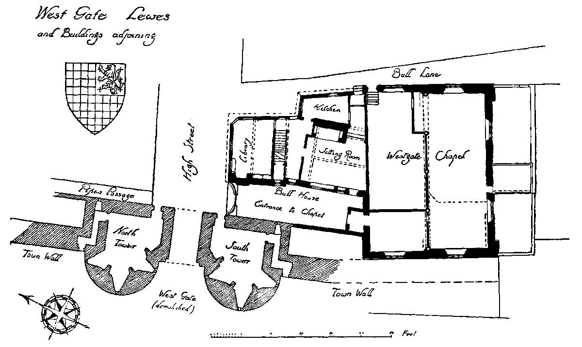
West Gate Lewes and Buildings adjoining
Nos. 99 and 100, west of Keere Street, (fn. 34) form a three-storied timber-framed building of Elizabethan date which has recently been stripped of its plaster face to expose the oak frame. It has a wing on the west side with bold projections of both the first and second stories towards the street, the upper overhang being carried by curved oak brackets. The first floor overhangs Keere Street, the framing being supported by shaped oak joists. There is a large open fire-place within, and some small portions of 16th-century panelling. In the framing on the High Street side is fixed an old milestone recording the distances of 50 miles from the Standard in Cornhill, 49 to Westminster Bridge, and 8 miles to Brighthelmston. This stone was formerly in the wall of the house (now demolished) on the opposite side of the way.
The parish boundary between St. Michael's and St. Anne's passes between Nos. 101 and 102, which with No. 103 have now 18th-century fronts. No. 103 is, however, mainly of early-16th-century date and has a large open fire-place in its main ground-floor room with an arched oak chimney-beam of unusual size, with spandrels carved with leaf ornament. The front room is panelled with Elizabethan oak panelling and has an overmantel of two arched panels, with fluted arch-moulds of the same date, over an elaborate Georgian fire-place. There is a good 18th-century summerhouse in the garden.
Antioch House (No. 104) and its garden belonged to the manor of Plumpton. It is a large house very much altered from time to time, but retains some Elizabethan stone windows. The date 1671 occurs on a rainwater head and 1763 on a south projection. On the first floor over a chimney-breast is an early-17thcentury wall-painting of a sporting scene. Rotten Row (fn. 35) enters the High Street here by a circularfronted Georgian Cottage (No. 105). Antioch Street, the next turning, appears formerly to have led down to Southover, but had been closed before 1595, (fn. 36) after a fire, which seems to have occurred in 1559. (fn. 37) Beyond it is St. Anne's Rectory (No. 110) on the site of the church of St. Peter Westout. St. Anne's House (No. 111) is an early-Georgian house, remodelled in the late 18th century. It has the date 1719 with initials I.A. on a rainwater head. The same initials (for John Apsley) and the date 1753 are on the garden wall. Between this and the churchyard of St. Anne's Church are a number of 18th-century houses and cottages, among which the chief are Hill Lodge (No. 118), Ashdown House (No. 119), and the old rectory of St. Michael's (Nos. 120–1).
Opposite St. Anne's Church on the north side of the street is Ireland's Lane, mentioned by John Rowe as 'alias Bukettwin where the bounderstone of this Burrowe lyeth.' Eastwards is the Pelham Arms, an inn with the sign of the Dog from 1745 to 1784. (fn. 38) A little farther east is Shelleys, now a private hotel. The part of this house towards the street is Elizabethan, altered and furnished with new windows in the 18th century. The central projecting porch has an original stone doorway with four-centred moulded arch and jambs, moulded stops and in the spandrils anno 1577. t.p. The arch is within a framework composed of an entablature resting on two Doric columns and within the porch is an original moulded oak frame to the entrance. The initials are those of Thomas Pelland, beer-brewer, and at that time the house was an inn with the sign of the Vine. (fn. 39) The most interesting internal feature belonging to this period is the mural painting on the walls of one of the rooms on the first floor. The main scheme is a trellis with interlacing lozenges at the intersections, the spaces being filled with floral patterns, and the frequent repetition of bunches of grapes. At the top is a broad frieze of finely drawn amorini and birds in the midst of a running floral pattern. (fn. 40) There is some Elizabethan panelling on the first floor, and in the entrance hall is a stone tablet with the Shelley arms supported on either side by amorini. This tablet must have been brought to the house since the Shelley family first occupied it in 1663. They remained until 1859 and during their occupation large additions were made on the north front, mostly during the 18th century. These rooms are excellent examples of the Georgian period.
The next building eastwards is the Grammar School, a modern structure on the site of the Chantry House, the endowment of Sherman's Chantry in St. Peter Westout. (fn. 41) The property was given in 1709 by Mrs. Mary Jenkins of Chelsea to the Lewes Grammar School and served as the schoolmaster's house until the school was moved here from Southover. Little Owsden (No. 138) and its neighbour Owsden House (No. 139) were formerly one house. In the former, which is largely timber-framed, is some good oak panelling c. 1600. On a gable looking north is the date 1654. Tyne House (No. 140), the Lewes and County Club (No. 141), and the Corner House (No. 142) are all of the 18th century. No. 143, the head-quarters of the Y.M.C.A., is on the site of an important building once the home of John Rowe, and the last house in St. Anne's parish. Westgate Street or White Lion Lane, named from an inn of which records exist since the time of Queen Elizabeth and now (1939) being demolished, turns to the north outside the town walls. Within No. 147 and its neighbour the Lewes Masonic Hall is a considerable section of the northern bastion of the West Gate. (fn. 42) This was built about 1300, and consisted of two square towers, with circular fronts to the west, flanking the gateway. The whole building measured 68 ft. across and 30 ft. in depth, the gate itself being 10 ft. wide. (fn. 43) The basement of the northern tower is now the cellar under the Freemasons' Hall, and part of the external facing of the curved bastion, of greensand stone ashlar, is visible under the floor of the building. The external face of the town wall alined with the western arch of the gate, and its junction with the bastion can be seen. The wall stands for some 10 ft. of its height within the building and can be viewed from the first floor of the Freemasons' Hall, whence it continues northwards alongside Pipes Passage. The passage-way mounts by means of steps the earth bank, part of the Saxon defence to the western approach to the town.
Next to St. Michael's Church eastwards is an old house, built in the 16th century, which formerly belonged to Lord Howard of Effingham. Nos. 163 and 164 are tile-hung, with an early-18th-century eaves cornice. Nos. 165–7, built about 1812, with a front adorned with pilasters of the 'Ammonite Order', stand on the site of the White Horse Inn. The centre house, Castle Place, was the residence of Dr. Gideon Mantell, the discoverer of the Iguanodon. (fn. 44) In front of Castlegate, leading to Lewes Castle, formerly stood the Market House at the western end of the market. Barbican House (No. 169) at the eastern corner of Castlegate, the head-quarters of the Sussex Archaeological Society, is an Elizabethan house, refronted and to some extent remodelled in the 18th century. It retains a stone fire-place on the ground floor, with four-centred arched head and moulded jambs, which in its spandrils has leaf sprays, the initials I.M.H., and the date 1579. In the ceiling of this room are contemporary moulded oak beams, and similar beams occur upon the first floor. The upper part of the main stair has spiral balusters of the time of Charles II and the firstfloor landing has an enriched ceiling of the same date. The rooms fronting the street have 18th-century fire-places, &c., and the lower flight of the stair is of the same period. The framing of the roofs and of the upper story is of heavy oak of the latter part of the 16th century. A room on the first floor is panelled with Tudor panelling from Bishopstone Manor House. Nos. 171–2 (rebuilt in the 18th century) were formerly one house devised to the poor of Lewes by Thomas Blunt in 1611. No. 173 (Moat House), (fn. 45) now rebuilt, retains two 18th-century panelled rooms, and its earlier Elizabethan and 17th-century fittings are now at the Museum at Anne of Cleves House, Southover. Nos. 174 and 175 were formerly one house (Morley House) with three gables and tile-hung upper story. This is an oak-framed building of the latter part of the 16th century and contains a considerable amount of Elizabethan oak panelling. In the rebuilt front of the Rainbow Tavern (No. 180) is an elaborately carved key-stone mask from its 18th-century predecessor. Pope's Entry passes under the building to the Castle Ditch where, built into a stable, is the arch of a 16th-century doorway enriched with guilloche ornament. The East Sussex County Council offices on the site of Newcastle House (Nos. 181–3, the last house in St. Michael's parish) have been built as a replica of the old building (fn. 46) and preserve on the front the sundial with the date 1717. A large panelled room, with two free Corinthian columns, two marble chimney-pieces, and an interesting staircase have been preserved from Newcastle House and incorporated in the building. The County Hall was erected in 1812 from the designs of Mr. John Johnston of Camden Town. It is faced with Portland stone and has an open colonnade (now partly filled in) on the ground floor between two wings of which the lower parts are in rusticated masonry. Behind on the ground floor are the Courts where the assizes, &c., are held. The first floor is occupied by a large room 60 ft. by 30 ft. and 27 ft. high, lighted by tall windows on the street front. Above the three central windows are panels carved in relief, and the whole building is crowned by a simple modillion cornice.
Fisher Street (fn. 47) (in line with Station Street on the south) marks the eastern limit of the market-place, and near its eastern angle with the High Street is the present Town Hall. Its 14th-century undercroft probably belonged to the house of Robert Spicer, M.P. for Lewes 1322–4. The principal compartment, 46 ft. by 20 ft., with its longer side adjoining the High Street has walls of sandstone rubble 4 ft. high, which support an elliptical barrel vault, the crown of which is 10 ft. 9 in. above the paved floor. The vault is of ashlar and its excellent condition suggests that it may have been worked over or renewed in the 18th century. A spiral stone staircase (shaped as part of an octagon outside) projects into the north-west corner of the undercroft and has a three-centred stone doorway. The stairway to the street is 5 ft. wide and commences well within the vault, between wing walls of ashlar, and beneath a chamfered segmental arch of two orders, the first and lower order having corbelled shoulders. The staples for a door at the foot of the stairs are still in the walls. Half-way up the stair are the jambs and part of the arch of a moulded 14th-century doorway, which was probably recessed somewhat from the external wall face. The steps continue to road-level beneath the pavement. On the road side of the vault are three sloping shafts, 1 ft. 9 in. wide and about 4 ft. high, cut through the wall, with ashlar sides, sloping floor, and above a sloping vault of two stones pitched like a roof. Whether these shafts were for light, ventilation, or as a runway for small parcels of goods it is not possible to determine. Some 6 ft. of the eastern part of the vault has been rebuilt in brick. The undercroft extends another 19 ft. eastwards to a stone wall running north and south and projecting 14 ft. north of the vault, probably originally a second cellar. During the 18th century the building was the Star Inn, the principal inn of the town, and it was during this period that the great Jacobean staircase from Slaugham Place was brought here and built in. (fn. 48) When the inn was converted to its municipal purpose it was largely rebuilt above ground and the stair was altered to a twin flight to the first landing and was made out with some modern work in replica. It is a fine example of Jacobean workmanship, having square newels with pedestal finials, all with enriched panels carved on the solid. The subjects of the carving include the five continents, five senses, musical instruments, rose and thistle, &c. The balustrade is arcaded with rich pilasters beneath an elaborate moulded handrail and the string is carved with a continuous strapwork design.
The Council Chamber is panelled with Elizabethan oak panelling preserved from the old building. It has a series of pilasters and is now painted. Among the municipal plate is a silver-gilt steeple cup bequeathed by Thomas Blunt to the town in 1611. (fn. 49) The rest of the plate dates from after 1800, including the mace and the mayoral chain. There are two Constables' staves of office (1629), another of 1760, two headboroughs' staves, and the brass badge of the town crier (1708). The arms of George III (1773) are preserved from the Old Town Hall.
Eastward of the Town Hall, at the top of School Hill, stands the War Memorial (a group of sculpture by the March brothers in memory of those who fell in the European War, 1914–18), on the site of St. Nicholas Church. This, before its removal in 1792, had ceased to function as a parish church for some centuries. (fn. 50) In its tower was hung the town bell known as Gabriel which now hangs in the market tower in Market Street, which turns northwards from High Street at this point. The tower, which is of red brick, was built in 1792 and has on its east wall a wellmodelled cartouche with the town arms in relief thereon, and swags on either side. This work is in terracotta (painted), probably from the 18th-century works of Jonathan Harman of Heathfield, but the design has a 17th-century character and may have been cast from the mould of an earlier shield. The bell is inscribed 'Gabrielis menti dedens habio nomen' and also 'Johannes tonne me fecit'. It has a large shield with the royal arms, a figure of St. Catherine, a medallion of Henry VIII, a crown, and a Tudor rose. (fn. 51) It also has a later inscription cut upon it, with 1792, the date of the removal.
Market Street leads to North Street, where is the old Naval Prison, built in 1793 as the town jail and now used as a Territorial head-quarters. In the chapel is a fine achievement in carved wood of the arms of William III, as used in Scotland (with the Scottish lion in the first and fourth quarters, and the lion and unicorn supporters interchanged), which used to stand over the entrance to the prison.
The houses on the end of the High Street turning into Market Street include Old Bank House and the Crown Hotel (formerly the Black Lion) both with good Georgian fronts. Nos. 199 and 200 are a pair of four-story houses with curved bay windows, and twin front doors under an elliptical overdoor, built in 1790. No. 203 is dated 1735 on the rainwater heads, with the initials i.s.m. (Dr. John Snashall and his wife Mary), and has a good entrance door, panelled front room, and stair of the period. Albion Street is on the site of the Turk's Head, a successor of the town house of the Dobell family, the property being part of the manor of Houndean. (fn. 52) Nos. 211, 212, and 213 are good Georgian houses, the last-named having some Elizabethan carved stones built into its front wall. No. 214 is on the site of Holy Trinity Church, which adjoined the East Gate. (fn. 53) Between the site of the East Gate and the bridge over the river are several 18th-century houses, the chief being Nos. 220 and 221, originally one building. It is faced with Caen stone, evidently taken from Lewes Priory, and has two large curved bay windows towards the street. The parapet is carried up in a central pediment in which is a sundial bearing the motto of the Isted family nosce te ipsum.
History
The history of Lewes (fn. 54) in early times is very obscure; there does not appear to have been any settlement on the site of the later town in prehistoric times, and there is no evidence of occupation by the Romans, (fn. 55) despite the proved proximity of Roman roads (fn. 56) and the general suitability of the site for defence against Saxon raids. (fn. 57) There are several Saxon burial-grounds in the neighbourhood, (fn. 58) and the earthwork of St. John's churchyard may have been the site of the earliest settlement. (fn. 59) The earliest reference to Lewes is in the Burghal Hidage, a document perhaps of the early 10th century or even earlier, (fn. 60) where a district of 1,300 hides is attached to Lewes; (fn. 61) this is a smaller area than those centring on Hastings or Chichester, but the borough of Lewes became pre-eminent in Sussex, for in the laws of Athelstan (925–35) it had a mint with two moneyers, whereas Chichester and Hastings had each only one; (fn. 62) and Athelstan himself appears to have on at least one occasion assembled his witan at, or close to, Lewes. (fn. 63) In the reign of Edward the Confessor it emerges as the virtual capital of East Sussex and as a market centre. (fn. 64)
In Domesday Book Lewes is the first item under 'The Land of William de Warenne;' it was apparently, like Chichester, extra-hundredal, and it is called a borough. That it was a port and market town of some importance is shown by the customary payments to the reeve on the sale of horse, ox, or man, and the service of schypfyrd due to the king. (fn. 65) In the time of King Edward there were 127 demesne burgesses; the number at the time of the Survey is not stated, but there were then about 258 'haws' or burgage tenements attached to manors within the rape, (fn. 66) and the population has been estimated at some 1,500 persons. (fn. 67) By 1086 the total fixed rents and issues had risen from £26 to £34 (as compared with £35 received from Chichester); (fn. 68) half went to the king and half to William de Warenne, (fn. 69) but there is no later evidence of the king's financial interest in the borough. These total issues included, in the time of King Edward, a sum of £6 4s. 1½d. from gablum, or burgage rents, and market dues, but there is no statement as to the source of the balance. (fn. 70)
Of the 258 haws or burgesses in Lewes associated with 35 outlying manors, 207 were attached to lands held by William de Warenne himself, or by his mesne tenants, the remaining 51 to lands held from other tenants-in-chief. Thus the Archbishop of Canterbury held 7 haws in Lewes belonging to the manor of Stanmer, and 21 haws belonging to South Malling; the Bishop of Chichester had 3 burgesses appurtenant to Henfield and 3 to Preston; the abbey of Hyde had 10 burgesses appurtenant to Southease, and Battle Abbey 7 burgesses belonging to Alciston, but probably associated with Ovingdean. (fn. 71) The rents paid from the haws varied from 2d. (paid to Perching) to 5s. (paid to 'Laneswice'), but 6d. was the most usual payment from each haw. The number of haws bore no relation to the area or assessment of the manors.
It is probable that, as at Chichester, (fn. 72) many of these haws soon lost their connexion with the outlying manors, though in some cases the connexion was undoubtedly maintained till quite recent times. (fn. 73) It is curious how large a part of Lewes was still held of outlying manors till recently, (fn. 74) and still more curious how few of these enclaves can be traced back to Domesday. Land in the parish of All Saints, Lewes, was attached to the Bishop of Chichester's manor of Bishopstone in the rape of Pevensey, though it does not so appear in Domesday. A free court was held for the bishop's tenants in Lewes in the parish of All Saints, every three weeks in the 14th century, (fn. 75) and a custumal of the same period names nine tenants of Bishopstone holding plots in Lewes. (fn. 76) This property lay, in whole or in part, between Walwers Lane and Church Lane in the parish of All Saints, (fn. 77) including School Hill House; it is possible that the haws attached to the bishop's manors of Henfield and Preston had been transferred to Bishopstone.
Hurstpierpoint, to which no haws are assigned in Domesday, had lands between Church Lane (Pinwell Street) and Broomans Lane. (fn. 78) The manor of Portslade had five freeholds in 1631, on the western side of Keere Street. (fn. 79) Another freehold tenement is alleged to have been held of Kingston-by-Lewes, in the parish of St. Michael; a tenement called Garretts, on the east side of St. Mary's Lane, of Hamsey; (fn. 80) and numerous freehold properties in Lewes, especially in the parish of St. John-under-the-Castle, of the manor of Southover, (fn. 81) and others of Houndean. (fn. 82)
From the days of the grant of his Sussex lands to the first Earl Warenne, the lords of Lewes barony (q.v.) were likewise the lords of the borough. The Norman and Angevin period should have been a time of prosperity for Lewes, for the powerful overlords were frequently resident in their castle, and the great Cluniac priory of their foundation (fn. 83) brought both visitors and trade, and yet for the greater part of the Middle Ages the history and status of Lewes are wrapped in obscurity. Although Lewes is latterly described more frequently as a villa than as a burgus there was no real loss of status; for it was a parliamentary borough from 1295, (fn. 84) and was assessed for taxation at the borough rate and under that description in the 14th century. (fn. 85)
Apart from the major disturbance of the Barons' Wars, (fn. 86) and 'that detestable battle of Lewes', (fn. 87) the history of Lewes in the 13th and 14th centuries is devoid of striking incident. Frequent royal visits (fn. 88) no doubt left their mark on the life of the town. Of equal interest locally were the more domestic happenings, for example, the visit, the severity, and the miracles of St. Richard of Chichester, (fn. 89) a brawl between the bailiff and the prior's men in a Lewes tavern, (fn. 90) intermittent struggles between earl and priory, which might threaten the peace with display of force, (fn. 91) thefts of the priory goods, (fn. 92) or the prohibition of tournaments. (fn. 93)
A house of Grey Friars had been founded here by 1241, (fn. 94) and there was a school in Lewes as early as 1248, which it is possible Archbishop Peckham later attended. (fn. 95) In this period Lewes had considerable claims to be considered the county town; the county court was frequently held there despite the rival claims of Chichester; (fn. 96) the dispute between them was only finally settled by Henry VII in 1504 when he ordered that the court should be held alternately at Chichester and Lewes: (fn. 97) justices frequently sat there to hold the assizes, (fn. 98) and later, commissions of oyer and terminer (fn. 99) and sessions of the peace. (fn. 100)
Some indication of the status of Lewes may be obtained from the sums it produced in taxation. In the time of Edward I, a tax of a twentieth produced £6 12s. 8½d.; (fn. 101) in 1334, the tenth produced a mere £4 1s.; less, that is to say, than Chichester, Shoreham, Arundel, Midhurst, or Stenyng. (fn. 102) Thus Lewes at the time was no competitor with Chichester in wealth, whatever its claims in age or dignity. In the war tax of 1340 it had a very similar position in relation to the other boroughs; (fn. 103) in that year 27 Lewes men paid tax, as against 36 at Shoreham, and many more at Chichester. (fn. 104)
Hostilities with France had inevitable repercussions upon Lewes life at this period, for the 'alien priory' of Lewes, dangerously near the coast, was constantly subjected to royal or comital control; even the charter of denization granted in 1351 (fn. 105) did not end such control. (fn. 106) In 1360, licence was given to crenellate the priory. (fn. 107) The life of the priory must have been a predominant factor in the lives of Lewes citizens—its 'lamentable condition' in the 13th century, no less than its improved tone in the 14th. (fn. 108) The church, as always, in medieval England, lent the colour of its pageantry to cheer the citizens. St. Pancras Day (12 May) (fn. 109) and Whitweek especially were celebrated at Lewes. (fn. 110)
In 1379 the French sailed up the Ouse within sight of Lewes, and they also landed at Rottingdean, where they were attacked by the local levies under the Prior of Lewes, who was taken prisoner. (fn. 111) The lack of patriotism then shown by the Earl of Arundel, who left his castle of Lewes undefended, may help to account for the outbreak against the earl at the time of the Peasants' Revolt, when the castle was attacked and damaged. (fn. 112) The men of Lewes were especially conspicuous in Jack Cade's rebellion of 1450, (fn. 113) pardons being issued for many inhabitants of the parish of All Saints, men from the Cliffe, Westout, and Southover (including the constable of Southover), the prior and convent of Lewes and their men, the burgesses of Lewes, and even the two constables. (fn. 114) The status of the Lewes participants is characteristic of that revolt.
Perhaps the most important local happening in the Tudor period was the foundation in 1512 of a new school, the Lewes Free Grammar School, at Southover, by the will of Agnes Morley; its story has already been told. (fn. 115) The school was fortunate in surviving the dangers of the Reformation, which brought about the surrender of the priory in November 1537, (fn. 116) whereby the greatest church in Sussex was converted into a quarry for all the builders in the neighbourhood. (fn. 117) The surrender of the poverty-stricken house of Grey Friars followed a year later. (fn. 118) Other religious changes were less significant. The hospitals of St. James in Southover and St. Nicholas in Westout lost their main supporters with the disappearance of the priory, and gradually ceased to function, though the latter continued its work irregularly as an almshouse. (fn. 119) And Sherman's Chantry, in the parish of St. Peter, was confiscated in 1547. (fn. 120)
The priory and its estates were granted to Thomas Cromwell, whose accounts contain many entries of expenses in connexion with his Lewes property in 1538, or with arrangements for pulling down the priory. (fn. 121) There is nothing to show that he himself ever visited Lewes, but his son Gregory and his wife converted part of the priory into a residence and were there in May 1538, but moved into the country through fear of the plague. (fn. 122) In June there was even a rumour that the King would visit 'your lordship's house at Lewes', and the lodgings were viewed to that end, but there were still cases of plague in Lewes, and perhaps for that reason no more is heard of the visit. (fn. 123) In 1539 Cromwell's household there was dissolved. (fn. 124)
This outbreak of plague in the spring of 1538, perhaps centred in St. Michael's parish. (fn. 125) Cromwell brought pressure to bear on the 'honest men' of the parish of St. Anne to allow those who died from plague to be buried in their churchyard; 'after consultation together for half a day and a night' they still demurred, for their parish was free of infection; yet finally they were persuaded to agree. (fn. 126) One other parish (not mentioned by name) was also infected. (fn. 127) On 24 May no one had died for eight days and no one in the town was then ill. Yet in the next month there were still other cases; another death, in an inn, was reported. (fn. 128)
In the Tudor period Lewes maintained its contested claim to be the chief town of Sussex. It now housed the county gaol, (fn. 129) and the county court was held alternately at Lewes and Chichester. (fn. 130) By a similar compromise the quarter-sessions for the western half of the county were held at Chichester and those for the east usually, though not always, (fn. 131) in Lewes. (fn. 132) The assizes were also still held here upon occasion; (fn. 133) in 1565, the borough expended 13s. 4d. on 'making a place for the justices of assize to sit', (fn. 134) and the expense of their entertainment might be a heavy item. (fn. 135) In the same year a new 'sessions house' was built by the borough, (fn. 136) and was used both as a town hall and as a meetingplace for county officers. The place of Lewes in the general political or military history of the 16th century was insignificant; it was a natural meeting place, for example, for justices discussing the organization of Sussex beacons, (fn. 137) and it was several times used as a distributing centre for gunpowder and shot, (fn. 138) 'sent thither for the defence of the most dangerous partes of this coast'. (fn. 139) It was thus easy for the defeat of the Armada to be celebrated by 'shooting off the great pieces in the Castle'. (fn. 140)
Elizabethan Lewes is known to us largely through the labours of that arduous Sussex antiquary and practising lawyer John Rowe, who was a resident and a benefactor of the town. At one time constable of Lewes (1598), and for 25 years steward of Lord Abergavenny, (fn. 141) he based his researches not only on the town-book (fn. 142) but on gleanings from court-rolls, many of which no longer survive. (fn. 143) His work is chiefly of value in the picture of the government and constitution of the town.
Taking a long view, John Rowe was, perhaps, the most important of Lewes residents in the late 16th and early 17th century. The families of men like Herbert Springett of Lewes, from whom the Springetts of Ringmer descended, kept up the family connexion, and left benefactions to the town; (fn. 144) John Kyme, at one time a Member of Parliament for Lewes, who lived at the Friars, was similarly a benefactor, (fn. 145) as was Thomas Blunt, whose silver cup, given in 1611, is now the oldest piece of the corporation plate. Thomas Twyne, doctor and writer, though not a Sussex man, practised at Lewes at the turn of the century, and brought to it a certain distinction. His son Brian, who was born at Lewes, spent some time in Lewes later, when he was vicar of Rye; he became in due course one of the earliest of Oxford antiquaries. (fn. 146) Nicholas Yonge, the musician, was born at Lewes but migrated to London. Such men have all received adequate recognition elsewhere. (fn. 147)
The enthusiasm for Protestantism, fanned by the Marian persecutions, during which 17 persons were burned for heresy at Lewes, (fn. 148) though none of them was an inhabitant of the town, was strong in Lewes throughout the 17th century. In 1603 there were no recusants in the parishes of St. John-under-the-Castle or St. Mary's Westout, and there were about 200 communicants in each parish. (fn. 149) Yet we have no record of any especial interest in the news of the discovery of the Gunpowder Plot, and there would appear to be no firm historical foundations for the so-called anti-Catholic tradition which made 'the Bonfire Boys' notorious in the 19th century (fn. 150) and still causes 'the Fifth' to be celebrated with exceptional pageantry. By 1640 Puritan influences were very strong in the eastern parts of the county (fn. 151) and it was feared that the town of Lewes and the sessions-house were so tainted that Puritans would be returned to parliament; (fn. 152) with the return of Colonel Herbert Morley and Colonel Anthony Stapley as members in the Long Parliament, the political sympathies of Lewes in the forthcoming struggle were finally determined.
Lewes did not play a conspicuous part in the Civil Wars; the committee of Lewes was busy, but its work does not seem to have been of any special importance. Arrangements for the defence of Lewes, both in money and men, were made in 1642; 200 or more volunteers were to be called in to the town; (fn. 153) 32 soldiers' coats, and 34 muskets and fowling pieces appear in the borough records for 1643–4. (fn. 154) Towards the end of 1642 Lewes was threatened, for after the sheriff's victory for the king at Chichester he set out with the Earl of Thanet to attack Lewes, but was routed at Hayward's Heath; (fn. 155) danger was again apprehended in August (fn. 156) and November 1643. After the fall of Arundel to Waller in January 1644, the town of Lewes sent the victor £50 in gratitude. (fn. 157) For the next few years there is nothing to record.
Both Lewes and Chichester were head-quarters of the Sussex committee for a time, (fn. 158) yet Lewes, continually in parliamentary hands, seems to have retained that position longer; (fn. 159) it had a branch of the committee of Plundered Ministers, set up by the Long Parliament—as had Chichester (fn. 160) —and of the commissioners for assessments in 1651, (fn. 161) and so on. The 'grand committee of the county' sat there in 1652. (fn. 162) MajorGeneral Goffe, in control of Sussex, Hampshire, and Berkshire, found Lewes well disposed to the Protector in 1655, (fn. 163) and relied upon the support there of John and Anthony Stapley; (fn. 164) but in 1657 the Stapleys were involved in royalist plots; (fn. 165) the plans included the surprising of Lewes and Chichester. (fn. 166) On the death of Cromwell precautions were taken against a royalist revolt in Sussex, and troops were raised at Lewes. (fn. 167) Lewes, like other Sussex ports, was used in this period by refugees to the continent, including Richard Cromwell. He was followed later by Edmund Ludlow, who stuck on a sandbank in stormy weather, but yet escaped discovery. (fn. 168)
After the Restoration Puritanism remained strong in East Sussex. Two incumbents, the Rev. Edward Newton of St. Anne's, and the Rev. Walter Postlethwaite of St. Michael's, 'the fathers of Lewes Nonconformity' (fn. 169) resigned on the passing of the Act of Uniformity; (fn. 170) in 1663 Lewes was still 'perverse' to the king's government; (fn. 171) the names of convicted persons might have been 'five times as many' and the conventicles were still much frequented. (fn. 172) There was trouble over the burial of a deceased Puritan, and his friends became 'insolent'; twenty shops were kept open in contempt on Christmas Day. (fn. 173) The difficulties met in the enforcement of the Act of Uniformity and the Conventicles Act in Lewes have been recorded in detail elsewhere; (fn. 174) there was one conventicle (Independent) in Lewes itself in 1669 (fn. 175) and two Independent conventicles were licensed after the Declaration of Indulgence. (fn. 176) In 1676 there were 687 persons who conformed, as against 173 nonconformists. (fn. 177) The strength of Puritanism certainly caused disquiet to the government; (fn. 178) thus it was reported to the Bishop of Chichester, early in September 1683 that 'this part of your diocese, as it is far remote from your palace, so is filled with a sort of men who are further remote from loyal principles than perhaps any other diocese'; (fn. 179) the bishop in turn complained that he 'had no hopes to reform the contempts of the laws . . . so long as they are abetted by men in the commission of the peace. . . '. Mr. Henry Shelley of Lewes especially was blamed; (fn. 180) he had indeed already been criticized for delays in proceeding against the Quakers.
Lewes in the 17th century must have been a pleasant place to live in, apart from the poorness of its communications. The road to Wootton, only 4 miles off, was a 'durty hard way to finde'; (fn. 181) in 1666 'the want of a post causes more lies daily than Mr. Muddiman writes truths in a month'; (fn. 182) in 1672 'no post comes into this county but at the two ends, but Lewes in the middle has no conveyance except by carriers'; (fn. 183) the carrier left the Talbot in Southwark at noon on Thursdays. (fn. 184) Lewes apparently became a post town shortly afterwards. (fn. 185) Despite its drawbacks, however, Lewes, in the time of Charles II, was 'esteemed the best borough town of the county'; it was 'a place of good antiquity, large, well-built, and well inhabited . . . beautified with divers handsome streets . . . '. (fn. 186) Defoe's comments some fifty years later were very similar; the especial merit of Lewes in his eyes was that both town and neighbourhood were 'full of the seats of gentlemen of good families and fortune'. (fn. 187) But few Lewes men in this period attained any considerable distinction. John Evelyn, the diarist, however, went to live with his grandfather there in 1625; he remembered years afterwards the solemnity of his grandfather's funeral at All Saints in 1627. Evelyn continued to live in Lewes with his grandfather's second wife; he laid one of the first stones in the new church of South Malling. In 1628 he began Latin with a Frenchman, one Citolin, who lived in Lewes; later he went to Mr. Potts's school in the Cliffe, and in 1630 to the free school at Southover. The family migrated to Southover on his grandmother's second marriage. (fn. 188) His subsequent relations with Lewes do not appear to have been very close. (fn. 189)
The 18th century was a period of quiet prosperity in the history of Lewes, when the amenities of life increased and a placid contentment was little disturbed by external or internal events of magnitude. The political interests of the inhabitants found an outlet both now and later in the sending of addresses, whether of congratulation or of protest; (fn. 190) they were shown in the coffee-houses of the town, (fn. 191) or when Tom Paine the excise-officer met his cronies at the White Hart, before ever he had dreamt of a political future beyond the Atlantic. (fn. 192) During this period smugglers were common enough in Lewes, as throughout Sussex. (fn. 193) Repercussions of the hostilities with France may be seen in the arrangements for the militia, (fn. 194) in a certain nervousness as to the possibilities of attack, (fn. 195) and in the welcome given to emigrés who came to Lewes. (fn. 196)
The Jury, who were really responsible for the government of Lewes in the 18th century, were slack in many ways, but showed perhaps some traces of enlightened social service. Grappling-hooks and buckets had long been provided against fire, (fn. 197) but by 1726 Lewes had an engine, and soon two, (fn. 198) the result of gifts, and in 1784 a new engine with 40 ft. of leather hose was bought by subscription. (fn. 199) In 1791 an enginehouse was put up to house this equipment. (fn. 200) That other scourge of the 18th century, small-pox, led in 1742 to a 'pest-house' being established for the use of the borough, (fn. 201) though not before it was needed. (fn. 202) In 1768 or 1769 the town crier 'cried the small-pox' (fn. 203) and there were several cases (fn. 204) in the next few years; the constables paid the expense of watching and nursing, and even for the shroud of a soldier's child who died there. As a result of a serious outbreak in St. Mary's Lane, it was agreed that a general inoculation would be a lesser evil than 'a general infection in the natural way'. From 14 to 20 January 1794 some 2,890 persons, 'according to the best accounts that the constables could procure', were inoculated, but of these 46 died as the results of the inoculation. (fn. 205)
In Lewes at this time many of the gentry, to mitigate the drawback of the county's bad communications, had town houses for the winter. (fn. 206) It is these residents who must be thanked for the comfortable 18th-century houses which still give the town its air of dignity, and for its many pleasant walled gardens: (fn. 207) there was 'such a rage for building in Lewes', that 'among all the brick kilns within two miles round' enough bricks could not be obtained to complete the new bell-tower. (fn. 208) There were many amenities in the town: there were the firstrate hostelries like the Star and the White Hart, to which the Crown and the Pelham Arms must now be added, (fn. 209) and the many other inns and ale-houses; (fn. 210) there were the coffee-houses; there were Lewes races, perhaps started in the reign of Queen Anne and flourishing early in the reign of George I, (fn. 211) which formed the first regular Sussex race-meeting to be recorded, (fn. 212) and which may have been kept up for a week, (fn. 213) with a ball or some other festivity every night; (fn. 214) there was a library of 523 volumes bequeathed to the borough by a clergyman in 1720, together with a small income to buy more books; (fn. 215) there were the local newspapers, the Sussex Advertiser, or Lewes Journal, started in 1745; (fn. 216) a 'neat, if not elegant', theatre was established in 1789; (fn. 217) and there were two banks, (fn. 218) and a freemasons' hall. (fn. 219)
No doubt the growing popularity of Brighton added to the gaiety of life in Lewes; George, Prince of Wales, was a frequent visitor as early as 1792. (fn. 220) Prince Ernest of Mecklenburg-Strelitz came in 1771 and 'liked the town so well, he said more than once he would like to live here'; (fn. 221) the Duke of Cumberland, too, was among the visitors in that year. (fn. 222) Wilkes and his daughter came in 1770 and people crowded to see 'the great patriot'. (fn. 223)
The political interests of Lewes citizens were shown in the early 19th century in a number of town meetings and resulting resolutions. (fn. 224) Gideon Mantell has described, too, the interest shown in the Peterloo massacres, and the decorum of the meetings to consider the resolutions, which he had helped to frame, (fn. 225) and also the sympathy shown for Queen Charlotte. (fn. 226) When the bill against the queen was thrown out in the Lords, Old Gabriel tolled, and there were illuminations and fireworks. (fn. 227) The public rejoicings on the victories of Trafalgar (fn. 228) and Waterloo, (fn. 229) and on the accession of George IV, (fn. 230) have also been described. Still more exciting in local annals was the visit of William IV and Queen Adelaide in October 1830, when Mantell's geological museum was to have been honoured by the royal visitors, but time did not permit. (fn. 231) When he was presented with a copy of The History of Lewes, the king merely muttered 'Take them—take them'. (fn. 232)
The tranquillity of life in Lewes was little disturbed by the many developments of the 19th century elsewhere. The administration gradually adjusted itself to the needs of the time; a new county hall was built in 1812, and the act which authorized this building empowered the lords of the borough to use it for courts leet and baron, and the constables for elections and public meetings. (fn. 233) The town was lit by gas in 1822; (fn. 234) pipes for the water-supply were laid by 1834; (fn. 235) the making of the railway was of a great interest locally, especially in view of what its excavation revealed on the priory site. (fn. 236) The old county jail was used to house a hundred Russian prisoners of the Crimean war, (fn. 237) and the officers on their release wrote a letter of thanks for their treatment to the senior constable. (fn. 238)
This building became a naval prison. A number of details about this 'house of correction', which was completed in 1793, are available. (fn. 239) The developments in Lewes government in the latter part of the century will be noticed later.