A History of the County of Oxford: Volume 12, Wootton Hundred (South) Including Woodstock. Originally published by Victoria County History, London, 1990.
This free content was digitised by double rekeying. All rights reserved.
A P Baggs, W J Blair, Eleanor Chance, Christina Colvin, Janet Cooper, C J Day, Nesta Selwyn, S C Townley, 'Wolvercote: Introduction', in A History of the County of Oxford: Volume 12, Wootton Hundred (South) Including Woodstock, ed. Alan Crossley, C R Elrington (London, 1990), British History Online https://www.british-history.ac.uk/vch/oxon/vol12/pp304-311 [accessed 1 May 2025].
A P Baggs, W J Blair, Eleanor Chance, Christina Colvin, Janet Cooper, C J Day, Nesta Selwyn, S C Townley, 'Wolvercote: Introduction', in A History of the County of Oxford: Volume 12, Wootton Hundred (South) Including Woodstock. Edited by Alan Crossley, C R Elrington (London, 1990), British History Online, accessed May 1, 2025, https://www.british-history.ac.uk/vch/oxon/vol12/pp304-311.
A P Baggs, W J Blair, Eleanor Chance, Christina Colvin, Janet Cooper, C J Day, Nesta Selwyn, S C Townley. "Wolvercote: Introduction". A History of the County of Oxford: Volume 12, Wootton Hundred (South) Including Woodstock. Ed. Alan Crossley, C R Elrington (London, 1990), British History Online. Web. 1 May 2025. https://www.british-history.ac.uk/vch/oxon/vol12/pp304-311.
Introduction
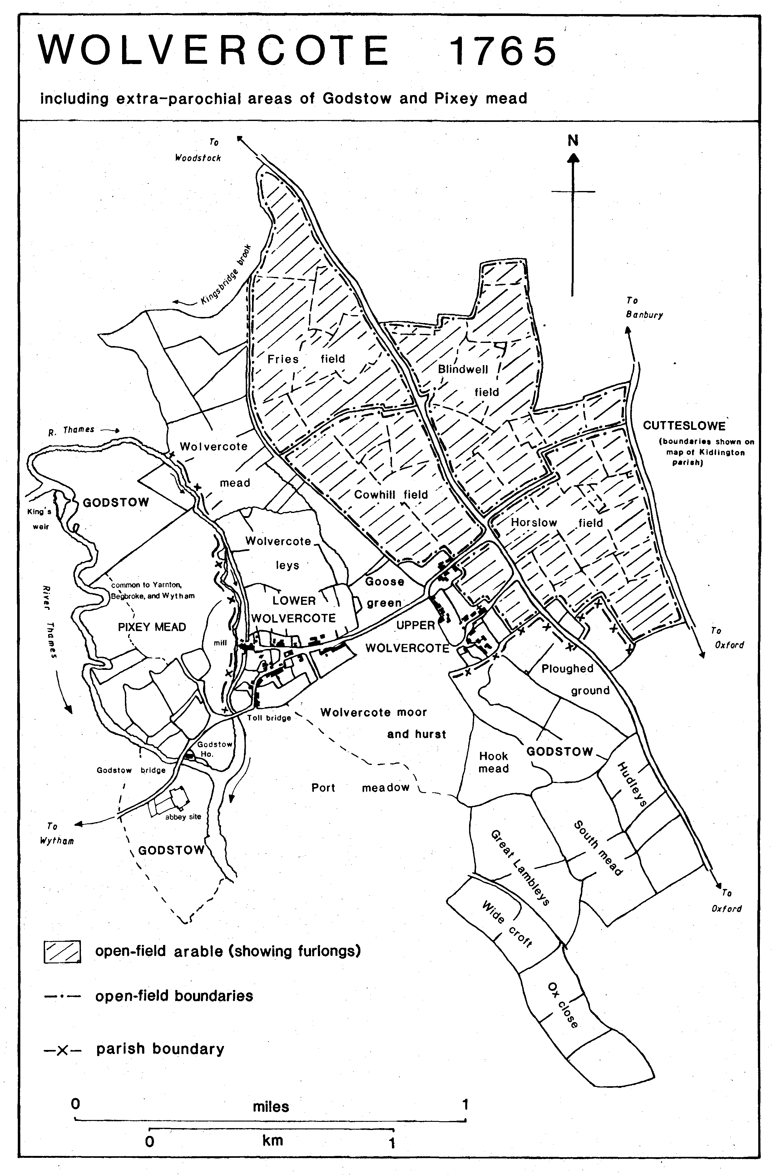
WOLVERCOTE, an ancient parish lying on the north-west of the city and liberty of Oxford, c. 2 ½ miles north of the city centre, contained two settlements, Upper and Lower Wolvercote; the adjoining extra-parochial areas of Godstow, Cutteslowe, King's Weir, and Pixey Mead were incorporated in the later 19th century. The south-eastern part of the parish, including Upper Wolvercote, was absorbed into the built-up area of Oxford in the earlier 20th century, and in 1929 the whole of the southern part of the parish was taken into the city. The boundaries of the earlier 19th-century parish (746 a. before boundary changes in 1857 and 1868) followed streams of the Thames on the west, the Banbury road on part of the east, small streams on part of the north, and field boundaries for the rest. The extra-parochial area of Godstow (411 a.), south and west of Wolvercote, was divided into four separate parts, three along the Thames in the west, and the fourth and largest (221 a.) between Wolvercote and North Oxford. The extra-parochial areas of King's Weir (0.09 a.) and Pixey Mead (51 a.), which was then common to Yarnton and Begbroke, lay north of Wolvercote. To the east was the extra-parochial area of Cutteslowe (281 a.). (fn. 32) To the south is Port Meadow, the common pasture of the Oxford freemen, where Wolvercote inhabitants have from an early date had rights of common. (fn. 33)
Wolvercote was, until the late 17th century, part of the ecclesiastical parish of St. Peter-in-the-East, Oxford, but it was a separate manor by 1086, (fn. 34) and remained independent of St. Peter's and of Oxford for all but ecclesiastical purposes. The north and east boundaries probably remained unchanged from an early date, apart from the transfer of Twisdelowe (later 40 a.) in the north-east to Cutteslowe in 1358; Twisdelowe was further transferred to Water Eaton in 1588. (fn. 35) The treatment, from the 16th century or earlier, of the demesne land and site of Godstow abbey as an extra-parochial area, altered the southern and western boundaries of Wolvercote substantially.
Godstow was composed of the site and demesne lands of Godstow abbey, a Benedictine nunnery founded c. 1133 on land given by John of St. John, the lord of Wolvercote manor. (fn. 36) The site of the abbey, between streams of the Thames, was thus presumably part of Wolvercote, although, unlike the rest of Wolvercote and Godstow, it was within the ridden boundary of Oxford. (fn. 37) To the west were three closes (14 a.) which were in the 19th century a detached part of Wootton hundred; it is possible that they had originally been in Wytham (Berks.), where Robert of Wytham and Abingdon abbey gave Godstow the meadows beside the nuns' church and bounding their garden. (fn. 38) A 16th-century account of the ridden boundary of Oxford suggests that it and the county boundary followed the same stream by the site of Godstow nunnery, perhaps passing east of the three closes, which seem to have been excluded from a survey of Godstow and Wolvercote in 1636. County maps of the 18th century placed the whole abbey site in Berkshire, suggesting uncertainty as to the county boundary, but an estate map of Wytham made in 1726 marked the westernmost stream as the Shire Lake, as in the 19th century. (fn. 39) Most of the rest of the extra-parochial area of Godstow, comprising the demesne land of the abbey, had formerly been part of Wolvercote, but the southernmost part, along the Woodstock road, had formed part of the abbey's manor of Walton in North Oxford. (fn. 40) King's Weir had also belonged to Godstow, being granted to the abbey by Reynold of St. Valery before 1156. (fn. 41) It was included with Godstow in surveys of 1636 and 1765, but was a separate extra-parochial area in 1841. (fn. 42)
Pixey Mead was given to Godstow by Reynold of St. Valery c. 1166; at that date Wolvercote, Yarnton, and North Leigh seem to have had an interest in it. (fn. 43) Later evidence suggests that the grant was of only the northern part of the meadow, later included in Godstow and calculated to be 53 a.; the remainder of the meadow was by the 18th century divided between the lords of the manors of Yarnton and Wytham (Berks.), the lords of Wytham having 14 ½ a. along the west side of the meadow, the lords of Yarnton the remaining 51 a. (fn. 44) The 14 ½ a. was included on an estate map of Wytham made in 1808, (fn. 45) but by 1876 it was part of Godstow. The 51 a. remained common to Yarnton and Begbroke. (fn. 46)
The extra-parochial area of Cutteslowe derived from an early grant to St. Frideswide's minster in Oxford of 2 hides of a 5-hide estate there. A confirmation of the minster's possessions in 1004 seems to describe an area roughly the same as that of the later estate. The boundary followed the Banbury road on the west and a stream on the east; Wilsey by the Cherwell was at the south-east corner, but the remainder of the southern boundary and the northern were probably altered in the mid 14th century when Oseney abbey exchanged 17 a. at Cutteslowe with St. Frideswide's priory for a total of 13 a. in Water Eaton. (fn. 47)
In 1341 Cutteslowe was included in St. Edward's parish, Oxford, presumably because St. Edward's had taken over St. Frideswide's parish church (closed in 1298), which had assumed the parochial functions of the minster church. (fn. 48) By 1556, when a Cutteslowe man requested burial at Wolvercote, (fn. 49) the area seems to have been served by Wolvercote church. An attempt in the 1660s to annex Cutteslowe to Kidlington parish failed. (fn. 50) The area was extra-parochial in 1771 and 1789. (fn. 51) Cutteslowe and Godstow formed a unit for payment of land tax, and Cutteslowe, Godstow, and Wolvercote for window tax. (fn. 52) Cutteslowe was included without comment in Wolvercote in the earlier 19th-century census reports. (fn. 53) It was separately entered, as a hamlet of Wolvercote, in the 1871 census, and as a civil parish in 1881. (fn. 54)
Godstow and King's Weir were united with Wolvercote by legislation of 1857 and 1868 dealing with extra-parochial places. (fn. 55) Under the Divided Parishes Act of 1882, small areas of Yarnton and Water Eaton, totalling only 2 a., were transferred to Wolvercote, increasing its area from 1,158 a. to 1,160 a. (fn. 56) The Local Government Act of 1888 transferred c. 38 a. of Wolvercote within the Oxford City boundary (most of the parish west of Godstow bridge) to Binsey civil parish, and the Local Government Board's Provisional Orders Confirmation Act of 1889 transferred the 14 a. west of that area, formerly a detached part of Wootton hundred, to the parish of Wytham, Berks. (fn. 57) Under the Oxford Extension Act of 1928 Wolvercote was divided between the city of Oxford (613 a.) and Cutteslowe (452 a.); under the same act 92 a. of Cutteslowe were transferred to Oxford, leaving 682 a. in the civil parish. In 1932, under the Oxfordshire Review Order, Cutteslowe, with the 51 a. of Pixey Mead common to Begbroke and Yarnton, was incorporated into the civil parish of Gosford and Water Eaton. (fn. 58)
Wolvercote 1765
including extra-parochial areas of Godstow and Pixey mead
The western part of the ancient parish lies on the alluvium of the Thames and of the old course of the Cherwell later followed by the Oxford canal. The eastern, higher, ground is on Oxford Clay and the Wolvercote gravel terrace, with an area of brick earth near the Water Eaton boundary. Lower Wolvercote village, the site of Godstow abbey, and Wycroft on the eastern edge of Port Meadow all lie on patches of flood-plain gravel; the nucleus of Upper Wolvercote, around the church, is on a patch of the Wolvercote gravel terrace, as is the 19th-century Pear Tree Farm in the north-east. (fn. 59) The land rises from 60 m. or lower along the Thames to over 70 m. in the east, along the Woodstock and Banbury roads. (fn. 60) The division between the lowlying alluvium and the higher gravel and clay has been reflected in the division of the parish into meadow and pasture in the west and arable in the east.
The Oxford-Banbury road, an ancient route which was called the port street (i.e. paved road to the market town) in 1004, (fn. 61) divides Wolvercote from Cutteslowe; it was turnpiked in 1755 and disturnpiked in 1875. The Oxford-Woodstock road, turnpiked in 1719 and disturnpiked in 1878, runs from south to north. (fn. 62) The liability for the repair of both roads was disputed in the earlier 17th century between the owners of land in Godstow, Wolvercote, and St. Giles's parishes. (fn. 63) The Oxford northern bypass, running across the north side of the parish, was opened in 1935, and the western bypass across the north-west corner in 1961. (fn. 64)
Upper Wolvercote was reached by Church Road (called First Turn in 1930), which branches westwards from the Woodstock road; it seems to have been described as a highway in 1736. (fn. 65) Another, probably smaller, road ran west from the Banbury road, through Upper Wolvercote and across Goose Green to Lower Wolvercote, roughly on the line of the modern Godstow Road, continuing to Godstow and Wytham. The section from Godstow bridge to Wytham was a private road, used in the 18th century and the early 19th only by the earls of Abingdon and their family; other travellers had to take a lane north-west through the meadows to cross the Thames at Wytham mill. (fn. 66) A road running between the Banbury and Woodstock roads, later called Five Mile Drive, appears to have been only an access road for fields west of the Woodstock Road in 1765; by 1821 it ran through to the Banbury road, but its course was altered at inclosure in 1834. (fn. 67)
Footpaths connected Wolvercote to Oxford, Yarnton, and Water Eaton. (fn. 68) Those to Oxford and Yarnton were used by Charles I in his night march from Oxford in June 1644. The path from Oxford presumably ran from Walton Street along the edge of Wycroft closes to Port Meadow. There seem to have been two paths to Yarnton. One ran north from Goose Green along the edge of Wolvercote Mead, keeping east of the Thames; the other branched north from the Godstow road just west of Toll Bridge along a lane marked on a map of c. 1730 as the way to Pixey, and then across Pixey Mead to cross the Thames by a ford at the end of Mead Way, Yarnton. The latter route was said in the 19th century to have been 'once the regular market road to Oxford', but had the disadvantage of crossing the Wolvercote mill stream twice, whereas the more easterly route avoided any major river crossing. (fn. 69)
The road from Wolvercote to Wytham crossed the Wolvercote mill stream and the main stream of the Thames by bridges that were in existence by 1139. (fn. 70) Godstow bridge, over the main stream, marked the northern boundary of the city and university of Oxford in the 15th century. (fn. 71) In 1718 the bridge, of two arches, was called Little Bridge; that year it was repaired by the duke of Marlborough. (fn. 72) The bridge was sold to the earl of Abingdon in 1811. (fn. 73) The southern arch was rebuilt in 1892, but the northern one was still partly medieval in 1984. (fn. 74) Toll Bridge, immediately west of Lower Wolvercote, was so called in the earlier 16th century, (fn. 75) presumably from tolls collected there for Godstow's fair. About 1540 it was called Stone Bridge. (fn. 76). The bridge was rebuilt in the 16th or 17th century, of five arches, a large one in the middle and two smaller ones at either end; the work may have been carried out soon after the Dissolution, for Anthony Wood remembered a song about the breaking of Godstow bridge and cross beginning 'Godstow bridge is broken down'; the cross stood at Toll Bridge. (fn. 77) The central arch of Toll Bridge was rebuilt in 1796 at the duke of Marlborough's expense; in 1876 the whole bridge was demolished and rebuilt by the county council, an attempt to force the University, as owners of Wolvercote mill, to carry out repairs having failed. (fn. 78)
In 1718 there was a third bridge, Wolvercote bridge, of three arches. (fn. 79) It may have been between Upper and Lower Wolvercote where a drainage ditch or ditches ran south from Wolvercote Leys to Wolvercote Common and Port Meadow. Between 1768 and 1770 the churchwardens mended bridges and a causeway, perhaps in that area, and in 1780 they built a new bridge of stone and timber. (fn. 80) West of the site of Godstow nunnery the old road to Wytham crossed the Shire Lake and another small stream. Of the two surviving bridges, that on the east has a pointed, possibly medieval arch.
In the 18th century, and probably earlier, there was a winch just above Godstow bridge to pull boats through the bridge. (fn. 81) In 1780 a cut was made through the site of Godstow abbey, to the west of the old navigation stream, and a pound lock was built at its lower end in 1790. (fn. 82) The cut, already over a foot too shallow in places in 1792, was widened and deepened by the Thames Conservancy and the Thames Valley Drainage Commissioners in 1884 and 1885. The road to Wytham crossed the cut by a bridge, built by the Thames Commissioners in 1780 and lengthened in 1885. (fn. 83) The Oxford canal was made through the parish in 1788, and the following year a short branch, Duke's Cut, was made for the duke of Marlborough, between the main canal and the north end of the Wolvercote mill stream. Its main purpose was to provide access to Wolvercote paper mill, but it also enabled boats to join the Thames above King's Weir. (fn. 84)
The Oxford-Rugby railway line was built through the parish in 1846, and the line to Bletchley, branching from it, in 1853. A halt at Wolvercote Green was opened in 1905 and closed in 1926. (fn. 85) Oxford buses were running to Wolvercote Turn before 1910, and a service from Carfax to Wolvercote village began in 1914. (fn. 86) Gas reached Upper Wolvercote in 1913, mains water before 1919, mains drainage c. 1920, and electricity by 1923. Despite several complaints, notably about the polluted water supply, no services were provided to Lower Wolvercote until after its incorporation into Oxford city in 1929. (fn. 87)
About 200 palaeolithic implements were found in the later 19th century near the junction of Five Mile Drive and the Banbury road in a long disused channel of the Cherwell. The medieval field names Twisdelowe and Hodelowe and the 17th-century Harslow and Henslow indicate the former existence of prehistoric barrows on the higher ground in the north-east part of the parish, (fn. 88) but the first clear evidence for settlement in the area is the Romano-British pottery found near the modern Oxford bypass in the north of the parish, and on the edge of Port Meadow, which suggests an extension of the scattered agricultural settlement of that date found in North Oxford. (fn. 89) There was a Roman villa on the boundary between Cutteslowe and Water Eaton. (fn. 90) The barrow from which Cutteslowe takes its name was associated with Cutha, possibly the West Saxon leader of that name killed in 584, but it is unlikely to have been his burial place, as its later use as a robbers' hideout suggests that it was a chambered long barrow. It was destroyed c. 1261 on the orders of the justices. (fn. 91)
The place name Wolvercote, Wulfgar's cottage or cottages, suggests that the settlement was at first a small and probably secondary one, but in 1086 a total of 20 tenants was recorded there. (fn. 92) There was also, by the 12th century, a farmstead or small settlement at Wyke or Wycroft 'farm inclosure' on a patch of flood-plain gravel on the eastern edge of Port Meadow; (fn. 93) the site, originally in St. Giles's parish, was later included in Godstow. In 1279 the abbess of Godstow had 33 tenants at Wolvercote, and the population of the village was swelled by some of the abbey servants. (fn. 94) As many as 144 people paid poll tax in Wolvercote and Godstow in 1377, (fn. 95) but the population had apparently declined by the early 16th century, and fell further after the Dissolution. There were only 25 tenants on the manor in 1541. (fn. 96) Forty-six men took, and one refused, the protestation oath in 1642; only 19 people paid hearth tax in Wolvercote (excluding Godstow) in 1662, and only 66 adults were recorded in the parish in 1676. (fn. 97) The population loss may have been due to the abandonment of the Walters' house at Godstow, which presumably employed a number of household servants as well as supplying work for the villagers.
Eighteenth-century curates estimated the size of the village as between 40 and 50 houses, except in 1771 when 36 houses, perhaps an accurate count, were recorded. (fn. 98) There was a considerable increase in population in the last two decades of the 18th century, probably associated with the expansion of the paper mill at that time. (fn. 99) By 1801 the 64 houses in the parish were occupied by 88 families, a total population of 341. The population rose steadily to 524 in 1831, fell to 470 in 1841, but rose again to 637 in 1851 when numbers were swollen by the temporary presence in the parish of 74 railway labourers. In 1861 the population was 617 and in 1871 it was 680, 665 in Wolvercote and 15 in Cutteslowe, figures for which had hitherto been included under Wolvercote. In the later 19th century the population rose rapidly as the northeast part of the parish was built up, reaching 1,351 in 1921, the last year for which separate figures are available. (fn. 1)
No tenants were recorded at Cutteslowe in 1086, and the account of the estate in 1279 has not survived, but 6 people were assessed for subsidy in the hamlet in 1316 and 8 in 1327. (fn. 2) Cutteslowe, never very large, seems to have been depopulated in the later Middle Ages. Only 7 people paid poll tax there in 1377, and the hamlet was not separately assessed for 16th-century subsidies. In 1662 six houses in Cutteslowe and Godstow were returned as liable to hearth tax. (fn. 3) Cutteslowe was included with Wolvercote in the earlier 19th-century censuses; in 1841 its population was 20. In 1871 it had two houses, occupied by 15 people, and the population was still only 20 in 1911. By 1921 houses had begun to be built in the township, and the population had risen to 63, but boundary changes reduced it to 62 in 1931. (fn. 4)
Wolvercote has, from the 16th century or earlier, contained two settlements, Upper Wolvercote around the church on the higher ground near the Woodstock road and Lower Wolvercote on the flood plain gravel near the mill. A house in the 'over town' was recorded in 1541; in 1542-3 there was also a 'middle town', perhaps the eastern end of the later Lower Wolvercote. (fn. 5) The division between the two settlements became more pronounced after the building of the canal in 1789 and the railway in 1846, and was particularly sharp in the early 20th century as Upper Wolvercote was absorbed into North Oxford. In the 18th century Upper Wolvercote was a small, scattered village, most of whose houses lay on or near the later Church Lane, although there were also a few houses on the later Wolvercote Green, and the substantial St. John's College farmhouse, later Manor Farm, further north. The church stood somewhat isolated on the eastern edge of the village. The houses of Lower Wolvercote lay on either side of the road to Godstow, and of its branch leading to Wolvercote mill. The road widened at the junction, in the west end of the village, into a small green, encroached on by 1765. By 1765 there was a cottage north of Upper Wolvercote, at the north-east corner of Goose Green, and in the early 19th century two or three others were built, besides a canal keeper's house on the west bank of the canal. (fn. 6)
Most of the older houses in both villages are of local rubble, and many probably incorporate stone from Godstow House or the abbey which preceded it. The Red Lion inn in Lower Wolvercote has above its southern ground floor window the two halves (reversed) of a late 15th-century doorway, and in the north gable of Manor Farm is a 15th-century corbel head of a king. The more substantial surviving early houses are in Upper Wolvercote. Church Farm House, west of the church, incorporates in its back wing fragments of an earlier 17th-century house, perhaps that built by Matthew Cheriton, a freeholder, who lived in a house on the site between 1625 and 1642. The front range of the house, with an external chimney in the parlour and an internal one in the dining room across the entrance passage, was built in the 18th century, perhaps by John Nicholls, one of its few owneroccupiers, between 1726 and 1742. The early 19th-century tenant, Henry Osborn, added a new and grandiose front, incorporating within it an early 16th-century doorway with a fourcentred head; he probably also reset some late 16th- or early 17th-century panelling and a fireplace with overmantel in the parlour, and a smaller fireplace in the room above. The work was probably done after 1829 when Osborn, who had earlier occupied only half the house, took over the whole. (fn. 7) Manor Farm was built by John Bell of Oxford University, on the site of an earlier house, shortly before 1636 when it was sold to St. John's College. It was refronted and otherwise improved in the early 19th century, presumably by the college tenant Richard Williams. (fn. 8) The house was again remodelled c. 1900 when prominent attic dormers were added to the west front and a new short hall was formed; c. 1970 a large music room was added on the east. Tudor Cottage opposite Manor Farm, demolished in 1951, had a 17th-century north wing incorporating a re-used 16th-century window head from Godstow. The house was substantially altered and enlarged in the 18th century. (fn. 9) No. 5 Wolvercote Green, another St. John's farmhouse, dates from the later 17th century. The neighbouring house, nos. 11-13 Wolvercote Green, is a large, brick-fronted farmhouse, probably built in the third quarter of the 18th century by Thomas Howell (d. 1764), a man 'of independent fortune', whose son Thomas owned it in 1765; it was altered in the earlier 19th century, probably by its owner John or James Dale, a builder and farmer. (fn. 10)
The oldest surviving house in Lower Wolvercote is probably the 17th-century 'Nunnery Close' at the western edge of the village. It was extended in 1702 by Richard Rowland whose initials appear on a datestone at the east end of the north wall. From 1764 to 1786 the house was a public house, the Crown, later the Cow; in the early 19th century it was divided into two and then three dwellings, but was occupied as a single house in 1884. (fn. 11) No. 11 Mill Road was built by the miller, John Beckford, c. 1700; in 1757 it was sold to the first of a series of brewers, and from 1771 was certainly an alehouse. From 1774 to 1821 or later it was the Boot, by 1834 it was the Crown; it closed c. 1837 and was thereafter occupied as a private house. (fn. 12) Two of the surviving public houses, the White Hart and the Red Lion, facing the small green in the centre of the village, are both of the mid 18th century. Many of the houses on Godstow Road are also of 18th-century origin; no. 67 has in a ground-floor room some re-used 17th-century panelling, presumably from Godstow House. No. 139 is part of a former workshop, built originally in the early 18th century and converted into a dwelling house c. 1800. (fn. 13) Most of the houses in Mill Road are of the 19th century; they include a good terrace (nos. 1-7) of rubble cottages with wood lintels. Other 19th-century houses, mostly of brick, are scattered among the earlier cottages in Godstow Road. Bedford House (no. 102), by contrast, is a substantial late Victorian villa, of ashlar, and nos. 85 and 87 are a pair of semidetached middle class houses.
Behind nos. 85 and 87 Godstow Road is the Rookery, a block of 8 small back-to-back houses, built in the 1880s or 1890s; each had one room downstairs and two small rooms upstairs, with a wash-house and privy in the garden. (fn. 14) A similar block to the west has been demolished. Cyprus Terrace, just south of the church in Upper Wolvercote is another late 19th-century terrace of workers' houses, slightly larger than those in the Rookery and not back-to-back.
West of Toll Bridge, on land considered part of Godstow not Wolvercote, is a small group of late 19th-century houses, built on an encroachment from the road. By the Thames at Godstow bridge is the Trout inn, dating from the 17th and 18th centuries. The first recorded house on the site seems to have been occupied by fishermen who leased the fishing from successive lords of Godstow and Wolvercote, but it was probably an inn by 1625 when the mayor of Oxford and his party lunched there on their way round the city franchises. (fn. 15) From 1707 onwards the house, which was within the boundaries of Oxford, was licensed by the city magistrates. Some additions seem to have been made to the house in 1720, using stone from the former abbey grange north of the road, but in 1737 it was almost entirely rebuilt by the tenant, Jeremiah Bishop, leaving only one room, on the south side, from the former building. (fn. 16) In the early 20th century an elaborate garden was laid out on the island opposite the house.
From the late 19th century the land along the Woodstock and Banbury roads was steadily built up as part of the development of North Oxford. From 1902 onwards, but particularly in the 1930s, the dukes of Marlborough leased or sold their land in the east part of the parish for building, and other landowners, notably the owner of Cutteslowe farm, did the same. (fn. 17) Houses were also built in Lower Wolvercote, but because of the railway and the canal that has remained distinct from North Oxford.
Their nearness to Oxford made Wolvercote, Godstow, and to a lesser extent Cutteslowe, popular with undergraduates and Oxford citizens. Anthony Wood recorded visits to alehouses at Cutteslowe and Godstow in the 1660s and 1670s. In 1662 undergraduates rescuing a comrade from the stocks at Wolvercote (where he had been put for stealing a goose from Port Meadow) broke all the windows in the village. (fn. 18) Eighteenth-century undergraduates, perhaps more decorously, played skittles at Wolvercote and Godstow, and Jeremiah Bishop, the inn-keeper at Godstow, was said at his death in 1771 to have been 'well known to most of the gentlemen who have been members of this university within the last 50 years'; Woodforde visited the inn on several occasions, referring to Bishop as 'old Jerry'. (fn. 19) Three or four alehouses (excluding the Trout, then called Godstow House, which was within the city) were usually licensed in Wolvercote parish in the mid 18th century. In 1774 they were the Red Lion, the Boot, and two called the Crown. The Blue Boy, later the Green Man and finally the White Hart in Lower Wolvercote, first appeared by that name in 1782, although a former owner had been licensed to sell ale in 1771. The Plough, on the green in Upper Wolvercote, first appeared by that name in 1812 and may have been new then; the house was rebuilt in 1840. (fn. 20) In 1984 there were three public houses in the village, the Plough, the Red Lion, and the White Hart; none of them has ever achieved the popularity of the Trout.
In most years between 1680 and 1880 horse races were held on Port Meadow; in the earlier 19th century the churchwardens of Wolvercote took toll from those attending. (fn. 21) Another annual event was the Whitsun Ale, which continued, probably unofficially, until 1772 or later, the churchwardens on two occasions paying for 'crying the Whitsun Ale down. In the later 19th century the Foresters' Friendly Society held its annual festival on Whit Monday, with a church service, cricket match, and entertainment. (fn. 22)
Godstow was made famous from the late 12th century by its association with 'fair Rosamund' the daughter of Walter Clifford and mistress of Henry II, who was buried there in the late 1170s. Her tomb, originally in the chancel but moved out of the church on the orders of St. Hugh, bishop of Lincoln, was destroyed at the Dissolution, but its supposed site was shown to visitors into the 19th century. A hazel tree on the site of the tomb, which was said to produce nuts with no kernels, was the subject of a sonnet by Robert Southey. (fn. 23)
Wolvercote, like the other villages around Oxford, suffered in the Civil War. Royalist troops, including the artillery, were billeted there in 1643 and 1644, and part of the mill was adapted for grinding sword blades. (fn. 24) The out-break of 'morbus campestris' in the summer of 1643 spread from Oxford to Wolvercote, where 21 people, including 2 soldiers, died in June, July, and August. Mortality was again high in 1644, perhaps because of plague. (fn. 25) In September 1644 parliamentary troops from Banbury attempting to arrest 'a gentleman of quality', perhaps David Walter, attacked the village on a Sunday morning. They disrupted the church service and took the duke of York's dwarf but failed to capture their main quarry. (fn. 26) David Walter fortified Godstow House for the king, but evacuated it in May 1645. Although he fired the house, it was not completely destroyed and the parliamentary forces were able to occupy it for a time. (fn. 27) A coin hoard buried in or shortly after 1646 testifies to the continuing fears and uncertainties in the parish. (fn. 28)
Wolvercote was the scene of an early flying accident in 1912 when two officers of the Royal Flying Corps were killed near Toll Bridge. They are commemorated by a large marble plaque at the north-east end of the bridge. An airfield was built on the north end of Port Meadow during the First World War, and the site was used for a short time in the Second World War as a military camp. (fn. 29)