A History of the County of Essex: Volume 8. Originally published by Victoria County History, London, 1983.
This free content was digitised by double rekeying. All rights reserved.
'Parishes: Roydon', in A History of the County of Essex: Volume 8, ed. W R Powell, Beryl A Board, Nancy Briggs, J L Fisher, Vanessa A Harding, Joan Hasler, Norma Knight, Margaret Parsons (London, 1983), British History Online https://www.british-history.ac.uk/vch/essex/vol8/pp227-240 [accessed 30 April 2025].
'Parishes: Roydon', in A History of the County of Essex: Volume 8. Edited by W R Powell, Beryl A Board, Nancy Briggs, J L Fisher, Vanessa A Harding, Joan Hasler, Norma Knight, Margaret Parsons (London, 1983), British History Online, accessed April 30, 2025, https://www.british-history.ac.uk/vch/essex/vol8/pp227-240.
"Parishes: Roydon". A History of the County of Essex: Volume 8. Ed. W R Powell, Beryl A Board, Nancy Briggs, J L Fisher, Vanessa A Harding, Joan Hasler, Norma Knight, Margaret Parsons (London, 1983), British History Online. Web. 30 April 2025. https://www.british-history.ac.uk/vch/essex/vol8/pp227-240.
In this section
ROYDON
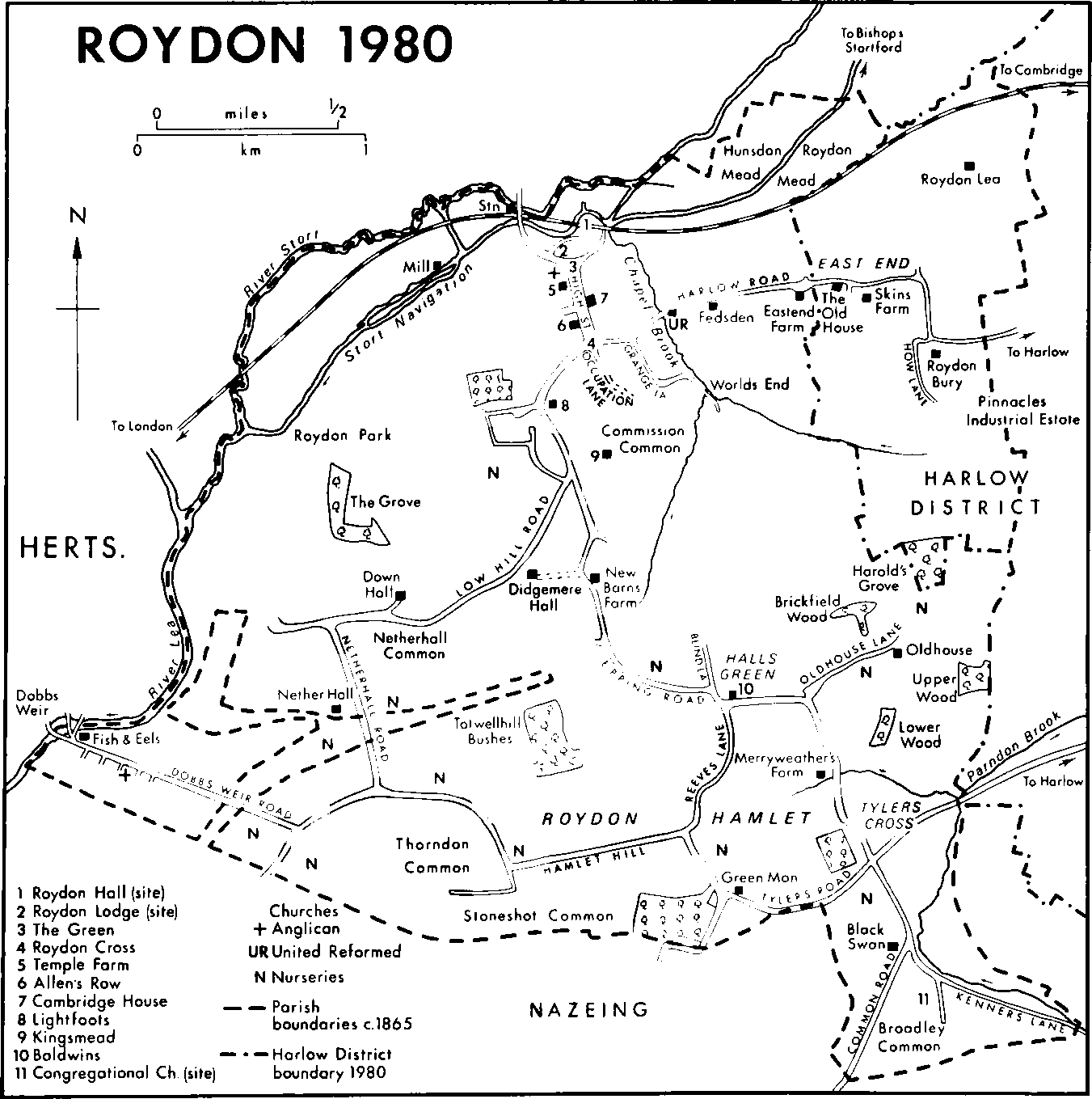
Roydon is 35 km. NNE of London, within the metropolitan Green Belt. Harlow Town adjoins it on the east, and Nazeing on the south. On the north and west the rivers Stort and Lea form the parish and county boundaries. (fn. 1) The ancient parish comprised 3,031 a. (1,227 ha.). (fn. 2) A limb of Nazeing, south of Nether Hall, was transferred to Roydon in 1946. (fn. 3) In 1955 changes on the eastern boundary reduced the area of the parish to 1,135 ha. (2,805 a.). (fn. 4)
The land, which reaches a height of 66 m. on the east and 78 m. on the south, slopes to the river meadows on the north and west. A stream flows north-east from the centre of the high ground, joins another which rises near the eastern boundary, and flows north to the Stort as the Meeting or Chapel brook. (fn. 5) One of a network of small watercourses feeding the Stort powered Roydon mill, which was bypassed when the Stort navigation was made in the 18th century. A stream which rises in the south-east skirts Broadley common to meet another at the eastern parish boundary as Parndon brook. (fn. 6)
Roydon was divided by the hundred boundary. (fn. 7) The northern part, in Harlow hundred, was called Roydon Town. The southern part, in Waltham hundred, was called Roydon Rothe in the 15th century, and later Roydon Hamlet. (fn. 8) In 1086 the two manors had a total recorded population of 28. (fn. 9) From the 14th century Roydon, including the hamlet, has been the third most populous parish in Harlow hundred, exceeded only by Harlow and Hatfield Broad Oak. For lay subsidies 49 men were assessed in 1327 (fn. 10) and 42 in 1525. (fn. 11) In 1670 there were 56 houses, and 105 ratepayers were named in 1734. (fn. 12) The population rose from 667 in 1801 to 796 in 1821. The 1841 total was inflated to 976 by the inclusion of railway navvies. The established population was 950 in 1871, and 1,005 in 1901. It rose to 1,262 in 1931 and to 2,619 in 1971. (fn. 13)
Until the 20th century Roydon was a parish of scattered farms and cottages, with the main settlements in the north-west and south-east. Paleolithic and Neolithic flints have been found near New Barns Farm, and Roman pottery near Tylers Cross. The discovery in the parish of Roman silver coins was recorded in 1855. (fn. 14) The more nuclear settlement in the north-west lay along High Street, which stretches from the Green to the junction with the Harlow-Epping road at Roydon Cross. By 1351 settlement had begun to spread south from the church and manor houses of Roydon Hall and Temple Roydon, along High Street, and by the end of the 16th century there were houses on both sides of the street and around Roydon Cross, (fn. 15) where a market cross stood in the 17th century. (fn. 16) There was little further change in the pattern of settlement before 1777. By then a gentleman's house, Mount Pleasant (later Fedsden), had been built in Harlow Road, replacing an older house. (fn. 17) Other large houses were built in the 19th and early 20th century, among them Roydon Lodge, Beaumont Hall, Roydon Bury, and Kingsmead. (fn. 18) Didgemere Hall, a stone house in the Cotswold style, was built in 1910 at the top of Low Hill Road, (fn. 19) where other expensive residences were built in the 1920s and 1930s. At the same time building began in Grange Lane and along Harlow Road.
ROYDON 1980
In Roydon Hamlet settlement in the later 18th century was mainly round Broadley common and near the greens, remnants of the forest, that straggled across the hamlet. (fn. 20) In the early 19th century Broadley House was partly rebuilt as a gentleman's house, and Joseph Sibley, who lived there, later built Elmwood and Sibley's Row in Common Road. (fn. 21) There was little further growth in the hamlet until the 1920s and 1930s, when the rapid spread of nurseries stimulated house building in Epping Road, Hamlet Hill, and Tylers Road, while farther west, at Dobbs Weir, a settlement grew up beside the Stort close to Broxbourne and Hoddesdon (Herts.). (fn. 22)
In the period 1922–39 Epping rural district council built 70 houses and bungalows in Roydon. The built-up area was extended before the Second World War by ribbon development and after the war by housing estates. In the late 1940s riverside sites began to be used for residential and holiday caravans and bungalows and in 1951 week-end bungalows were built behind Skins Farm on an old Quaker graveyard. Between 1948 and 1966 the council built 149 houses and bungalows. In the 1960s the village was extended northward by an estate on the site of Roydon Lodge and a row of houses north of the vicarage. (fn. 23) The village centre was designated a conservation area in 1973. (fn. 24) The village green survived in 1980 with the cage, whipping post, and stocks. (fn. 25)
Roydon's road pattern has changed little since the late 16th century. (fn. 26) The northern end of High Street was diverted in 1777 by Sir George Jackson (later Duckett), Bt., promoter of the Stort navigation, to run between the church and the canal, skirting his new estate. (fn. 27) Grange (formerly Ing) Lane, off Harlow Road, crossed Horsecroft common in the 16th century, but by 1777 it stopped at World's End. Occupation Lane, leading from Roydon Cross to Halls Green, was gated at each end of Commission common in the 16th century. Its southern end, Blind Lane, was closed by the inclosure award of 1859, which also closed a lane fom Hamlet Hill to Tylers Cross. How Lane, which in the 16th century led from Harlow Road to Oldhouse Lane, fell out of use after 1920. (fn. 28) Dobbs Weir Road was built c. 1857. (fn. 29)
In the 17th century the Shire and Millshead bridges carried the road from High Street to Stanstead Abbots (Herts.) over the Stort and its tributary. The lord of Roydon Hall maintained Millshead bridge and part of the Shire bridge. (fn. 30) A wooden bridge over the canal, which replaced Millshead bridge was rebuilt in concrete in 1920 by Essex county council. (fn. 31) Hertfordshire county council rebuilt the Shire bridge in 1802, changing the watercourse so that the bridge was in Hertfordshire. Essex paid £100 to be exempt from its maintenance. (fn. 32) At Dobbs Weir the only river crossing in the mid 19th century was a bridge over the old Lea, built in the 1830s in place of a deep ford. (fn. 33) A brick bridge over the new Lea, built in 1878 by public subscription with contributions from the parish and county, was adopted in 1883 by Essex and Hertfordshire county councils and rebuilt in concrete in 1934. (fn. 34) Bradley bridge, mentioned in 1482, was probably over the tributary of Parndon brook. (fn. 35)
In 1769 the Stort navigation was completed from Bishop's Stortford (Herts.) to the confluence of the Stort and Lea, running for the most part south of the old river. To avoid the serpentine course of the Stort, the canal was cut along the mill river, bypassing the mill. It was well used until competition with the railway from London to Bishop's Stortford caused a sudden decline in the 1840s, halving its revenue. The locks and channels deteriorated under successive owners and in 1909 one side of Brick lock in Roydon collapsed, trapping barges for nearly six months. In 1911 the Lee Conservancy board took over the navigation and in 1920 began to rebuild the locks. (fn. 36) A fleet of steel barges, built to navigate the original narrow channel, operated until 1956. In 1980 the canal was used by pleasure boats only. (fn. 37)
By 1741 coaches from Harlow were passing along Harlow Road and High Street to join the London road at Hoddesdon. (fn. 38) The Northern and Eastern railway's London-Cambridge line reached Bishop's Stortford in 1842, the track crossing Roydon between the Stort and the canal. (fn. 39) Roydon station, designed by Francis Thompson with a curved portico on the road frontage and a fretted platform canopy, was built c. 1844 near the level crossing and canal bridge, opposite the entrance to Briggens Park in Hunsdon (Herts.). The platform canopy was removed in 1971. The building was disused by 1978 and remained unoccupied in 1980. (fn. 40)
A post office had been opened in High Street by 1863. (fn. 41) By 1898 there was another at Broadley Common. (fn. 42)
There are four inns in High Street. (fn. 43) The earliest recorded there by name is the White Horse, on the site of a building used intermittently as a public house since 1671 or earlier. (fn. 44) Its 19th-century brick front on Harlow Road conceals a timber-framed building, probably of the 18th century. The New Inn, recorded in 1769, is an early 17th-century timber-framed building on the site of a late medieval house of which the south cross wing survives. The White Hart, a long timber-framed building, perhaps of 17th-century origin, was an alehouse by 1789. The Crusader, formerly Temple, inn was built as a public house in the early 19th century, of yellow brick with slate roofs. (fn. 45) The Plough (later Plough Cottage), Epping Road, was a beerhouse in the 1870s. (fn. 46) At Roydon Hamlet 10 inns have been named, of which three survive. The Black Swan, an early 16th-century building, was an inn by 1769, and was almost wholly rebuilt in the 18th or early 19th century. (fn. 47) The Fish and Eels, Dobbs Weir, was also recorded from 1769, and the Green Man from 1779. The Fox and Hounds, listed 1845–63, was apparently replaced by the Fox and Goose farther south in Epping Road from 1870 to 1899. In the 1870s the Hop Pole, Broadley Common, was a beerhouse, and the Eagle, later Eagle House, Hamlet Hill, was a public house. (fn. 48)

ROYDON VILLAGE c. 1597
During the Middle Ages there were manor houses on four sites: Roydon Hall, Temple Roydon, Nether Hall, and Down Hall. They and two medieval houses belonging to Winchester College are described under manors. Houses survive on all those sites, except that of Roydon Hall. Among other surviving medieval houses are Cambridge House, the Old House, and Whitegates. (fn. 49) Cambridge House, 68 High Street, was given to Christ's College, Cambridge, in 1513 for an obit, by Edith Fowler, gentlewoman to Margaret Stanley, countess of Richmond and Derby, who endowed the college with Roydon Hall manor. (fn. 50) The house was probably built in the 15th century on the site of an earlier house. The north end is on a three-roomed plan with a stack against the cross passage. In the 17th century part of the first floor was heightened and given a jetty on the east side, where a short wing was added at the same time. The house was later extended to the north. In the later 18th century the central three bays were refronted in brick with a parapet. The college sold the house shortly after 1914. The Old House at East End, built early in the 16th century, contains original moulded timbers. Whitegates, 82 High Street, is a medieval house, built on a three-roomed plan. An upper floor and chimney stack were added in the 17th century. Brick casing of the 18th and 19th century masks the earlier origins of many houses in Roydon. Among them are nos. 120–122 High Street, Rosedale and Barry Cottages, the Dower House, and Lightfoots, all of 17thcentury origin. Nos. 120–122 High Street, encased in yellow brick, form a substantial house with a jettied first floor. Rosedale and Barry Cottages, 53–57 High Street, encased in grey brick, were built as one house, mostly with reused timber. The Dower House, 108 High Street, has a street range, probably of 17thcentury origin, encased in red brick. Lightfoots, Epping Road, comprises a main timber framed range with two rooms divided by a stack, and a south wing added in the later 17th century. The wing, partly of brick, was cased in the 18th century. Skins Farm, East End, was built in the 17th century, probably on the site of an earlier house; Skinners was a copyhold tenement in the 15th century. (fn. 51) Among original brick buildings of the 19th century is Allen's Row, 21–37 High Street, a terrace of seven three-storey yellowbrick cottages with cast-iron pivot windows under segmented brick arches. They were apparently built by Nathaniel and William Allen c. 1840 as a speculation when the railway was being built. (fn. 52) In Harlow Road St. Anne's, Dowsett's House, and the Old Bakery, formerly Rushes Farm, were built in the 18th century. Among substantial houses that have been demolished is Roydon (formerly Stort) Lodge, built c. 1825 apparently on the site of an earlier house, by Sir George Duckett, Bt., son of the promoter of the Stort navigation, who probably lived there until his bankruptcy in 1832. The house then comprised two storeys and a basement and was furnished with Chinese wallpaper and marble statuary. Photographs of 1966 show a house of irregular plan with a central tower, suggesting later 19th-century extension. (fn. 53)
The parish vestry laid a public sewer in High Street in 1857. A new sewer, serving c. 100 houses in the same area, was completed by Epping R.D.C. in 1913. The first mains water in the parish was supplied to High Street in 1910. St. Margaret's Gas Co. laid mains to Roydon c. 1904, and gas street lighting was installed by 1908. Electricity became available in 1928. (fn. 54)
A pleasure fair, held yearly on the Green on 29 June (St. Peter and St. Paul) in the 19th century may have been intended as a revival of a medieval fair held on the feast and morrow of St. Peter-in-Chains (1 and 2 August). It lapsed during the First World War, but was held again on the Green in the mid 1970s. A travelling fair visited other sites in the 1950s. (fn. 55) Traditional May-day customs survived in the 19th century. (fn. 56) There was a lending library in 1839. (fn. 57) In 1886 there was a workmen's club at the old school, and in 1893 a club house was built on the Green. A harrier pack was kept by Edward E. Barclay of Roydon Lodge in the 1890s, and by 1898 there was a cricket club and a cottage garden association. (fn. 58) Since the building of the village hall in Harlow Road in 1920, many local societies have flourished, among them an amateur dramatic society in the 1920s, a branch, founded c. 1946, of the London Institute of World Affairs, and the Roydon Society, founded in 1968. The parish owns 4 a. on Broadley common, granted by the inclosure award of 1859 for allotments and recreation, allotments (2½ a.) on Commission common, bought by the parish council in 1919, and an adjoining playing field, given in the 1950s. (fn. 59) The inclosure award also granted a wharf at Dobbs Weir to the inhabitants of Roydon Hamlet. In 1895 the parish council claimed tolls on the wharf from non-residents. In 1980 the wharf was a car park leased by the Lee Valley regional park. (fn. 60)
Sir Ralph H. Fowler (1889–1944) mathematician, was born at Fedsden. (fn. 61) The same house was from 1914 to 1933 the country residence of Sir Henry Bucknall Betterton, later Lord Rushcliffe (1872–1949), politician. (fn. 62)
Manors And Other Estate. All the manors of Roydon seem to have been derived, directly or indirectly, from estates held in 1086 by Ranulf brother of Ilger. The two largest estates became Roydon Hall, while the third probably became Nether Hall. Temple Roydon, which was formed from part of Roydon Hall, itself gave rise to Down Hall and the Winchester College estate.
In 1066 a manor of 6 hides in Roydon was held by Ingwar, an Essex thegn of Danish descent, and another 4 hides were held by five free men. By 1086 both estates had passed to Ranulf brother of Ilger, who held them in demesne. (fn. 63) Attached to them was a small outlying estate in Harlow, which became the manor of Sewalds. (fn. 64) On Ranulf's death c. 1100, his estates escheated to the Crown, which seems to have granted Roydon to the Baynard family, lords of the barony of Little Dunmow. (fn. 65) Roydon passed with Little Dunmow to the FitzWalters, who held it in chief and in demesne until the 15th century. (fn. 66)
About 1200 part of the capital manor was detached to become Temple Roydon. Other parts were merged in Nether Hall. The remaining lands, lying in the north and east became the manor of ROYDON HALL. Walter FitzWalter, Lord FitzWalter, last in the male line, died in 1431. (fn. 67) In 1423 he had granted the manor for life to Cardinal Henry Beaufort, bishop of Winchester (d. 1447). (fn. 68) FitzWalter's daughter and heir Elizabeth married John Radcliffe of Attleborough (Norf.) who fell fighting on the Yorkist side in 1461, and later John Dinham, Lord Dinham. She died before 22 August 1485, and was succeeded by her son John Radcliffe, Lord FitzWalter, who was attained and executed in 1496 for his part in Perkin Warbeck's rebellion. (fn. 69) His estates were restored in 1505 to his son Robert Radcliffe, Lord FitzWalter, who in the same year sold Roydon to Margaret Stanley, countess of Richmond and Derby, mother of Henry VII, and grandniece of Cardinal Beaufort. (fn. 70) In 1507 she granted the manor to Christ's College, Cambridge, her new foundation, which leased it to John Morice for 99 years. (fn. 71)
Henry VIII acquired the manor in 1531 from the college in exchange for other lands, and the next year granted it to Anne Boleyn. (fn. 72) In 1548 under the will of Henry VIII, the manors of Roydon Hall and Temple Roydon were granted to his daughter Mary. (fn. 73) Several leases of the manor, following those to John Morice, were granted in the later 16th and the early 17th century. (fn. 74) In 1602 Elizabeth I granted Roydon Hall to Thomas Bellot and others, who conveyed it in the same year to Robert Cecil, earl of Salisbury (d. 1612). Salisbury also acquired Temple Roydon. (fn. 75) The estate descended with the earldom until 1692, when James Cecil, earl of Salisbury, sold it to Sir Josiah Child, Bt. (d. 1699). (fn. 76) Roydon thus became part of the Wanstead House estate, and passed with it until after the death in 1863 of William Pole-TylneyLong-Wellesley, earl of Mornington. Mornington's executors sold the Roydon Hall estate in 1867 to Henry Cox Wilkinson, who sold it in 1875 to Henry Willoughby Adams, rector of Great Parndon. (fn. 77) In 1844 the estate comprised 820 a. (fn. 78) The manorial rights, excluded from the sales, passed to Mornington's heirs, the earls Cowley. (fn. 79) In 1980 Walter Durant Gibbs, Lord Aldenham, was lord of the manor. (fn. 80)
Roydon Hall manor house occupied a medieval site north-east of the church near the river Stort. A late 16th-century map shows it as a hall house with cross wings, apparently moated. (fn. 81) Henry VIII stayed there in 1538 with the infant Prince Edward. (fn. 82) The house, which was 'much decayed' by the early 17th century, was repaired by John Stanley, the lessee, c. 1604. (fn. 83) It was demolished and replaced by a farmhouse, probably by the end of the 18th century, and certainly by 1839. (fn. 84) The railway line runs through the original site. (fn. 85)
The manor of DOWN HALL, which lay in the west of the parish, appears to have originated as a free tenement held of the manor of Temple Roydon. It probably took its name from the family of Doune. In 1278 Raymond de Burdegale and his wife Joan conveyed to John de la Doune and his wife Agnes a messuage and 82½ a. in Roydon. (fn. 86) In 1329 Rose de la Doune conveyed to (Sir) John de Walton and his wife 5 messuages and 254 a. in Roydon and Parndon, presumably Great Parndon. Rose and after her William de la Doune retained life interests in the estate. (fn. 87) Sir John de Walton was succeeded in 1347 by his son, also Sir John, whose widow Margaret died in 1391, leaving as heirs her grandsons Ives Harleston and Robert Pakenham, between whom Sir John's Essex estates were apportioned in 1400. (fn. 88) Ives Harleston died in 1403, holding Down Hall, and manors in Steeple Bumpstead and Wimbish. (fn. 89) His widow Eleanor married John Wynter, who was holding the estate in 1412. (fn. 90) Ives's son and heir John died in 1457 leaving a son, also John. (fn. 91) In 1467 Henry and Robert Harleston, uncles of the younger John, conveyed the manor to Sir Robert Danby and others. (fn. 92) That was probably the prelude to its sale to Thomas Colte (d. 1471) of Nether Hall, whose widow was holding Down Hall at her death in 1475. (fn. 93)
Down Hall descended with Nether Hall in the Colte family until 1624, when Sir Henry Colte conveyed it to John Wright. (fn. 94) In 1632 John Waylet and John Hellam, with their wives Margaret and Mary, conveyed the manor to William Priestley. (fn. 95) William's son Thomas Priestley sold Down Hall in 1706 to Edmund Feilde (d. 1719), from whom it passed in succession to his sons Thomas, Edmund (d. 1729), William, and Paul Feilde (d. 1783), and his daughter Catherine Feilde. Catherine's will, proved in 1787, apparently caused a dispute, resolved in 1796 by an agreement by which Down Hall and other property passed to William H. Feilde. (fn. 96) Philip Hollingworth bought the manor in 1815 from W. H. Feilde, and sold it in 1821 to Sir George Duckett, Bt. (d. 1822). Duckett's son, also George, improved the farm and its buildings, but was bankrupt by 1832 when the estate was sold to John Hornby-Maw. (fn. 97) In 1844 Down Hall comprised 169 a., owned by James Ewing. (fn. 98) In the 1930s it belonged to the Abbey family, and in 1980, when the owner was Mrs. Beryl Abbey, Down Hall farm comprised c. 50 a. (fn. 99)
Down Hall, Low Hill Road, retains a half-H plan, and some of its rafters are of medieval origin. The present building, however, may be no earlier than the later 16th century. Most of the internal fittings are of the late 18th and early 19th century.
The manor of NETHER HALL lay partly in Roydon Hamlet and partly in Nazeing parish. It may have been identical with the estate of 1 hide held in 1086 by Odo of Ranulf brother of Ilger, and said to be in Nazeing but in Harlow hundred. (fn. 100) In the 13th century the FitzWalters of Roydon Hall were lords of some land in Roydon Hamlet, but the overlordship of Nether Hall was later attributed to Waltham abbey, (fn. 101) which had succeeded to most of Ranulf's demesne lands in Nazeing. (fn. 102) Waltham also acquired demesne lands in Roydon, (fn. 103) some of which were in Roydon Hamlet and in 1456 and later were part of the abbot's manor of Eppingbury in Epping. (fn. 104) In 1531 the abbey conveyed its demesne lands in Roydon with various lands in Hertfordshire to Henry VIII in exchange for the dissolved priory of Blackmore and some of its possessions. (fn. 105)
The tenancy in demesne of Nether Hall has not certainly been traced before the later 14th century, when the manor was bought by John Organ (d. c. 1392), a London mercer. (fn. 106) In 1403 Thomas Organ, son of John, vested it in trustees, who in 1406 sold it to Simon Barnwell also a London mercer. (fn. 107) In 1427 John Tattle and others sold it to Peter Shelley of Nazeing and his wife. (fn. 108) The manor later passed to Thomas Colte, a Yorkist, from whom it was seized by the Crown in 1460. (fn. 109) Colte, ambassador to France in 1465, recovered his lands after the accession of Edward IV and died in 1471 (fn. 110) holding Nether Hall. His widow Joan, who later married Sir William Parre, died in 1475, leaving John Colte her son and heir. (fn. 111) John (d. 1521), whose daughter Jane married Sir Thomas More, was succeeded by his son (Sir) George (d. 1579). Sir George's heir was his grandson Sir George Colte (d. 1615). (fn. 112) Sir Henry (d. 1635), son of the last Sir George, sold Nether Hall in 1631 to John Brooke, reserving a life interest to himself and his wife. (fn. 113) Brooke's son John sold the manor in 1680 to John Archer (d. 1707). (fn. 114) Nether Hall, which in 1844 comprised 242 a., (fn. 115) descended with Coopersale House, Theydon Garnon, and later with Hallingbury Place, Great Hallingbury, until after the First World War, when the Archer-Houblon estates were broken up. (fn. 116)
There was a house at Nether Hall in the 13th century. (fn. 117) By the later Middle Ages there were two adjacent but separate houses, one moated and brick built, the other smaller and timberframed. Both were probably built by Thomas Colte (d. 1471). (fn. 118) The brick house had an embattled curtain wall with angle towers and in the centre of the south side a three-storeyed gatehouse, which once bore the badges of Edward IV and his adherents. (fn. 119) There were buildings in the centre of the enclosed area and against the curtain walls, which were apparently demolished in the 1770s. (fn. 120) In 1980 only fragments of the curtain wall and parts of the gatehouse, all much overgrown with ivy, were standing. (fn. 121)
The second house is on the western side of the outer courtyard. Its centre is a substantial 15thcentury hall house with jettied cross wings. In the late 16th or early 17th century a chimney stack and upper floor were put into the hall, and additional cross wings were built beyond each end of the house. Both had jetties continuing the lines of those on the original wings, and that on the north also had a side jetty. In the late 17th century the upper floor of the later northern cross wing was removed and a single-storeyed addition was made beyond the wing. The interior was largely refitted in the 19th century.
The manor of TEMPLE ROYDON, lying in the north part of the parish, appears to have originated in a carucate of land given to the Knights Templars by Robert FitzWalter (d. 1235), who had succeeded his father Walter as lord of Roydon in 1198. (fn. 122) From 1202 the demesne tenancy was disputed between the Templars and Simon son of William (or Walter), who claimed as heir of his father, parson of Roydon; Simon called Robert FitzWalter to warranty and conveyed the land to the Templars in 1205. (fn. 123) In 1313, after the suppression of the Templars, the king granted the manor and rectory to his treasurer John de Sandale, later bishop of Winchester, who apparently granted the rectory immediately to his servant Thomas Folquardebi. Those grants appear to have lapsed, for later in 1313 the king granted the manor and rectory to the Knights Hospitallers. (fn. 124) Part of Temple Roydon became the manor of Down Hall, probably in the 13th or the early 14th century. (fn. 125)
At the Hospitallers' dissolution in 1540 Temple Roydon was held on a 60-year lease by John Morice, also lessee of Roydon Hall. (fn. 126) In 1548 Temple Roydon passed with Roydon Hall to Princess Mary. (fn. 127) In 1558, as queen, Mary gave the manor to the re-formed Knights Hospitallers, (fn. 128) but the grant lapsed on her death. In 1602 Elizabeth I granted Temple Roydon to Francis Norris, Lord Norris, and others, who conveyed it in the same year to Robert Cecil, earl of Salisbury. (fn. 129) From that time it descended with Roydon Hall. In the 17th century parts of Temple Roydon were sold and became the nucleus of the Winchester College estate. (fn. 130) In 1843 the Temple Roydon estate comprised 167 a. (fn. 131) It was sold c. 1924 with 308 a. as building land. In 1945 it was bought by the Frederick family, tenants since 1938, and sold in 1950 to sand and ballast merchants. In 1980 the house and 165 a. of farmland was occupied by the Frederick family. (fn. 132)
The manor house, later Temple Farm, has a main range which may retain the structure of a substantial medieval hall with a screens passage at its east end. In the early 17th century the house was 'in decay, wanting thatching and tiling'. (fn. 133) An upper floor and chimney stack were put into the hall later in that century, by which time the service end was probably demolished. The rooms at the parlour end of the hall were rebuilt in brick in the 19th century, when the south and east walls of the hall range were encased in brick.
WINCHESTER COLLEGE estate. (fn. 134) Charles Scott, vicar of Compton (Hants), by will of 1762, gave to the college Merryweathers (also called Bedfords), Spurlings, Reeves, and Baldwins in Roydon, Profits Hall in Nazeing, and lands called Maunds Esgors in Great Parndon. The Roydon lands were copyhold and freehold of Temple Roydon manor. (fn. 135) The estate had been built up over more than a century. In 1622 Sir Henry Colte, copyholder, sold Merryweathers to John Waylett. Waylett added other lands in Roydon and Parndon by exchange and purchase, and in 1643 sold all but the leasehold lands to Ralph Minors, who added Spurlings and Longacre to the estate. Ralph's son William Minors sold it in 1667 to Justinian Sherborne, who had bought Dunstalls in Great Parndon in 1665. Edward Sherborne, son of Justinian, succeeded to his father's land and also inherited Maunds Esgors from his mother. In 1689 he sold the whole estate to Robert Scott, who later added Profits Hall. Charles Scott, his son and heir, was the college's benefactor. The college extended the estate in the 1860s but sold it gradually between 1904 and 1921.
Of the houses in Roydon belonging to the estate only Baldwins and Merryweathers, both medieval, survive. Merryweathers may be associated with Roger Miryweder who was living in the 13th century and Baldwins with Baldwin of Barking (fl. 1208). (fn. 136) Baldwins, at Halls Green, is a small house containing a hall of two bays with a crownpost roof and a service bay. An upper floor was put into the hall and a large stack built against the back wall, probably in the mid 17th century. At Merryweathers the former open truss of a medieval hall survives in the north gable of the back range, but much of the range appears to be of the 17th century. The narrow front range was added in brick c. 1800 and most of the older work was cased in brick. (fn. 137)
Economic History.
In 1066 and 1086 Roydon manor, comprising 6 hides, had 3 demesne ploughteams and 4 belonging to the tenants. There was woodland for 120 swine, pasture worth 2s., and 60 a. of meadow. The recorded population was 22 in 1066(12 villeins, 2 bordars, 8 serfs) and 23 in 1086 (8 villeins, 12 bordars, 3 serfs). There were 60 sheep in 1066, but none in 1086; 6 'beasts' in 1066 and 10 in 1086; 30 swine at both dates; 10 horses in 1086. A mill had been built by 1086, and the value of the manor had risen from £6 to £9. The small manor in Nazeing, which probably became the manor of Nether Hall, was worth £1 in 1086 and had 1 villein, 4 bordars, and a ploughteam. The most striking changes since the Conquest had been the disappearance of sheep, and the arrival of 10 horses, referred to as equi, a word rarely used in the Essex Domesday, and which may mean riding horses connected with a hall. (fn. 138)
Later evidence shows that the extensive meadows mentioned in Domesday lay beside the rivers Lea and Stort. Most land transactions from the 13th century onwards include some meadow, and from the 15th century a third or more of the parish was meadow and pasture. (fn. 139) Field names include many leazes (common pastures) and holmes (water meadows), notably among the Roydon Hall and Temple Roydon lands in 1530. (fn. 140) The meadows were liable to flooding. Those to the north may have been permanently flooded in the 15th century, like those on the opposite bank of the Stort at Stanstead Abbots (Herts.). (fn. 141) Those to the west were also called marshes in the late 16th century. (fn. 142) Field names with the prefix 'new', used in the 17th century, suggest reclamation of such lands. In 1694 a sluice was needed between Nether Hall and Down Hall lands. (fn. 143)
By 1271 there was a fishery at Dobbs Weir (Tubbeliswere), belonging to Roydon Hall. (fn. 144) In 1344 a commission investigating obstruction of the river found it blocked at Roydon by a weir (Goldens weir), fish traps, piles, and an island. (fn. 145) Another fishery, belonging to Nether Hall, had been established at the New Weir by 1579. (fn. 146) Osier beds on some small islands were recorded in 1530, 1657, 1844, and c. 1856. (fn. 147)
The Woodland swine pastures mentioned in Domesday probably lay mainly in the south. In and after the 14th century Roydon Hamlet was within the forest of Essex and had its own reeve and cattlemark. The rest of the parish was in the purlieus. (fn. 148) There is evidence of woodland clearance in the 12th century. (fn. 149) In 1287 the abbot of Waltham granted his wood at Broadley to Robert FitzWalter, whose tenants had lost by inclosure their rights of pasture on Nazeing common. (fn. 150) In the 15th century many of the holdings were of a standard 10 a., and the position of those that can be located, on the outskirts of Roydon Hall manor, (fn. 151) suggests that they were assarts from the forest. By 1328 a total of 100 a. of Roydon Hall manor had been emparked. (fn. 152) In 1354 Edward III ordered 34 oaks and other trees there to be felled for his works at Westminister Palace and the Tower of London. (fn. 153) In 1530, when the park still contained 100 a., it was stated that 4 a. of it were to be sold yearly. (fn. 154) Only 80 a. remained in 1546, (fn. 155) but they survived in 1844, when there were 156 a. of woodland in the parish. (fn. 156) Most of Roydon wood, within the park, had been felled by 1876. (fn. 157) A remnant of it, protected by a preservation order made in 1950, survived in 1980. (fn. 158)
Like other riverside parishes in south-west Essex, Roydon had open fields and common meadows. They included Wysedome field, recorded in 1477, the location of which is not known. (fn. 159) By 1530 four of the arable open fields of Roydon Hall and Temple Roydon, called Great Broadmore, East and West fields, and Monnefield, had been inclosed, perhaps under an award which is suggested by the name Commission field, an open field recorded also in 1530. (fn. 160) In 1617 Horsecroft, Didgemere, and Langlands were named as 'the three common fields of Roydon'. (fn. 161) By 1844 Horsecroft, which in 1530 extended from East End to Ing Lane, had been greatly reduced, and Langlands had been inclosed. Several of the remaining strips in Commission, Didgemere, and Horsecroft, all three of which were called commons, had been consolidated. (fn. 162) In 1865 the three commons contained 130 a. (fn. 163) By ancient custom the northern river meadows provided common pasture after Lammas for the men of Roydon Hall and Temple Roydon. Pigs kept on the meadows between 1 August and 29 September were ringed, and sheep were allowed there only between 1 November and 2 February. No unattended cattle were allowed on the highways between 25 March and 1 August. (fn. 164) In the 1840s the railway cut through the Lammas lands and paid compensation to the parish. (fn. 165) There was further inclosure c. 1909 and after the First World War the Lammas rights fell into disuse. In 1980 the pinder kept only a few strips in Roydon mead belonging to the parish council. (fn. 166)
In Roydon Hamlet the arable open fields were called Stoneshot, Thorndon, Nether Hall, Harden Hill, and Woodley. The largest were Stoneshot and Thorndon, which adjoined Nazeing. The hamlet men enjoyed common pasture on Nazeing mead and on uncultivated forest waste. (fn. 167) Broadley common was stinted, and with the greens was driven every year for the fence month. (fn. 168) Infected and unmarked beasts were banned from the hamlet's commons. Pigs on Broadley common were ringed, and no runts, steers, or sheep were allowed there. (fn. 169) Parts of Harden Hill and Nether Hall commons had been inclosed by 1855. Some earlier inclosures were included in a parliamentary award of that date, which inclosed 120 a. of arable land in Stoneshot, Nether Hall, Harden Hill, and Woodley commons, 77 a. in Nazeing mead, 14 a. of greens and waste, and 78 a. in Broadley common. (fn. 170)
In the 17th century copyholders claimed the right to dispose of their timber and to let their holdings for three years without licence. The tenants claimed the right to have their bull and boar at Roydon Hall, and to dig in Broadmore field for turf and for sand and clay to repair their buildings. In 1604 and 1637 they accused John Stanley and John Southworth, the lessees, of imprudent lopping and felling. Stanley, also accused of denying customary rights and wood to the poor, indicted those who built and sublet cottages without land and those who combined two copyholds, letting one house to the poor, who became hedge breakers. (fn. 171)
References to the Vineyard (later Vinegar hills) at Roydon Hall occur from 1351; it is not known when vines were grown there. The manor had a warren in 1530 and a dovecot in 1352 and 1530. There were dovecots at Temple Roydon in 1530 and at Nether Hall in 1701. A saffron bed was recorded at Nether Hall in 1612. In the 17th century there was a hop ground at Merry weathers and another, called Loveday Moors, belonging to Roydon Hall. There were hop grounds at Down Hall in 1737 and at Roydon Hall c. 1856. (fn. 172)
Apparently there was an attempt at progressive farming at Down Hall in the early 18th century. (fn. 173) In 1844 there were eight farms of 50–100 a., six of 100–200 a., and two (Roydon Hall and Nether Hall) of over 200 a. More than a third of the acreage was meadow and pasture. (fn. 174) In 1866 Roydon had 1,041 sheep but the number fell to 513 in 1906 and 72 in 1916. Cattle increased as sheep declined. (fn. 175)
The sale of the Nether Hall estate, comprising 426 a., in 1919, coincided with the development of the glasshouse industry in the Lea valley. In 1920 the first glasshouses in Roydon were built in Netherhall Road, and in the next 20 years the production of tomatoes and cucumbers under glass for the London market spread rapidly from Dobbs Weir to Tylers Cross and Oldhouse Lane. In the early 1950s, when the industry was at its peak, more glasshouses were built at Park Fields. Italian workers, recruited under a post-war resettlement scheme, bought nurseries as their employers retired, and many holdings were fragmented. In the 1970s the rising costs of oil and labour accelerated the industry's decline. By 1980 tomatoes, lettuces, and flowers were the main crops of English growers; the Italians continued to grow mainly cucumbers. (fn. 176) In 1977 the agricultural holdings included 61 under 5 a., another 30 between 5 a., and 50 a., and only 2 over 120 a. (fn. 177) From the mid 1950s much of the riverside pasture in the south-west was exploited for gravel, and in 1950 Temple farm was bought by sand and ballast merchants. (fn. 178) More than 85 a. at East End, Roydon Lea, and Skins farms were bought for a golf course by Harlow development corporation between 1955 and 1966. (fn. 179) Of 640.5 ha. recorded in 1977 as agricultural land 237 ha. were grassland. (fn. 180)
There was a water-mill in Roydon in 1086, and a water mill was recorded in the 13th and 16th centuries. (fn. 181) Two mills recorded in 1718 were replaced in the early 19th century by one with four pairs of stones. (fn. 182) The mill was burnt down later in the century. By 1906 it had been replaced by a two-storey brick mill with a weatherboarded superstructure. It was powered by water and steam, and later by gas. Flour milling ceased c. 1930 but cattle food was ground by water power untile c. 1940. (fn. 183) In 1980 the mill survived as the office of the adjoining caravan site.
Among tradesmen recorded were tailors (1530, 1736, 1739), a silk weaver (1645), a glover (1622), a collar maker (1739), and a hardner (1683) who was probably a metalworker. The Manistrie family were tanners in the 17th and 18th centuries. There were references to bricklayers in 1683, 1702, and 1737. (fn. 184) There was a brick ground near the river in 1844, and a brickfield was being worked in 1877. (fn. 185) A brick-lined, dome-covered pit at Vinegar hills, identified in 1896 as a kiln, may have been an ice house. (fn. 186) The Imperial Brick Works was established at Old House farm in the late 19th century, when many houses in Roydon were fronted or cased in brick. There were 12 workers' cottages and 4 kilns for making tiles and bricks. The works was put up for sale in 1894 and reopened by 1898 as Roydon Brick and Tile Works, which survived until c. 1906. (fn. 187) Roydon hay carters and dealers trading with London are listed in directories in the late 19th and early 20th century. (fn. 188) In 1945 two warehouses and some Nissen huts were built near Roydon station for grain storage and drying. (fn. 189) In 1979 they were occupied by Inland Warehousing Ltd. A steeple jack, W. Larkins, whose firm was founded in Bow (Lond.) in 1897, moved to Roydon after the Second World War and in 1980 occupied the former engine shed at the railway station. (fn. 190) There was a timber yard at Broadley Common in the 1960s. (fn. 191) Roydon Bury was adapted for office use c. 1966, and Kingsmead House in 1974. In the 1970s the buildings of a disused mushroom farm at the Moors, Harlow Road, were used as small commercial and industrial units. (fn. 192)
Local Government.
In 1274–5 Robert FitzWalter claimed right of gallows and assize of bread and of ale and all other royal liberties except warren. (fn. 193) The rights of pillory, tumbrel, and gallows were claimed as late as 1670. (fn. 194) A book recording courts baron of Roydon Hall manor survives for the period 1470–1522. (fn. 195) There are court rolls and a book for short periods between 1554 and 1704, and two series of rolls 1689–1702 and 1743–1826. Temple Roydon court rolls survive for 1558, 1569–74, 1612, 1617, 1689, and 1693–7. (fn. 196) There is also a draft court book for both manors 1655–60. (fn. 197) Courts leet were recorded for both manors until 1761.
The manors were jointly owned from 1602, (fn. 198) and although separate courts baron were held, the leet business of both manors was apparently discharged in the court of Roydon Hall. From 1762 only courts baron were held. In the 16th century each court appointed 2 constables and 2 aletasters. From 1602 each pair of officers apparently served both manors. The court appointed constables until at least 1701, and aletasters until 1614 or later. A pinder was appointed regularly in the period 1603–1749. (fn. 199) The office was revived by the parish council in 1895, and survived in 1980. (fn. 200) The court's attention to commons, drainage, hedges, and highways is reflected in bylaws formulated in 1603. Victuallers were occasionally presented for breaking the assize and often warned. In 1607 two men were fined for an unlawful transaction in hides, and in 1609 a man was presented for taking partridges with dogs. (fn. 201)
Roydon Hamlet, which was part of Waltham manor, had its own leet. Its rolls survive for 1456, 1541, and short periods between 1673 and 1766. In the period 1724–34 no details except the homage were given. The court met in Whitsun week. (fn. 202) It appointed a constable in 1541 and in the 17th century, except for the years 1692–4, when the vestry appointed him. (fn. 203) The court also appointed a pinder regularly from 1679 until 1744, and a sand digger from 1720 until 1752. A 'townsman' representing the hamlet was appointed in 1676, 1679, and 1680. The court was mainly concerned with regulations governing commons, which were usually repeated at every leet. (fn. 204)
Surviving parish records include vestry minutes for 1604–1857. (fn. 205) In the 17th and early 18th century the vestry rarely met more than once a year. From 1727 it held a second meeting to settle accounts. It met four times a year from 1754 and monthly from 1799. A resolution of 1754 to fine absentees was repeated in 1799, when expenditure of 2s. 6d. at each meeting was authorized. That sum was doubled in 1803. In the period 1722–31 the Easter vestry met in private houses. In the late 18th century the parish church was usually given as the meeting place of the quarterly vestries but by the end of the century meetings were often held in private or public houses. The numbers signing the minutes varied in the 17th century between 3 and 22. In the 18th and 19th century 6 to 8, often headed by the vicar, usually signed. Richard Skingle, vicar 1682–1706, and Brian Kitchingman, vicar 1713–52, attended regularly. The vestry chose 2 churchwardens and 2 overseers regularly, and one of each pair apparently represented Roydon Hamlet. There is some evidence of a rota system for overseers. In 1821 and 1837 one overseer was paid £16 a year to serve both town and hamlet. A sidesman was appointed yearly in the 1680s. The town and hamlet each had 2 surveyors. In the 18th century constables of both divisions submitted accounts to the vestry and were occasionally chosen by it, as they were regularly from 1792. A reeve, rarely mentioned in the manorial court records, was chosen by the vestry in 1826. The vestry clerk, first mentioned in 1736, was salaried by 1777. In 1809 a paid assistant clerk was appointed.
Separate rates were levied for overseers, surveyors, and constables. In 1793 a 1s. rate was raised to pay a £100 fine imposed on the parish for not repairing highways. Annual dinners at surveyors' and overseers' meetings ceased in 1828. The town and hamlet rates were equalized from 1796 or earlier, any surplus being paid to the town overseer and the hamlet surveyor. In the early 1830s the town temporarily severed its connexion with the hamlet, which had tried to quash a rate.
In 1573 it was said that Roydon had more poor than it could support. (fn. 206) In 1604 the poor rate from 40 residents totalled £13 10s. 11d., most of which was paid to 11 poor. The annual cost of poor relief varied between £7 and £11 before the Civil War. It began to rise in 1654, and was more than £38 in 1667. In the 1770s the average annual cost was £277. Between 1801 and 1817 it was £413. (fn. 207) In 1811, when the population was 732, a 7s. rate produced £739 13s. In 1820 more than £912 was paid in poor relief. The parish had only two small charities for the poor. (fn. 208) The vestry augmented the poor rate and tried to discourage applications for relief in various ways. In the 17th century church rents and fines in the manor court were paid to the poor. (fn. 209) The poor also received 'communion money' accumulated in the period 1722–46. In the late 18th and early 19th century fathers of bastards made payments to the overseers of £14–£50. The vestry occasionally gave rate exemption to those who took in parish children, and set the poor to work instead of granting relief. (fn. 210) It resolved in 1714 to badge the poor, and in 1793 to pay up to 1s. weekly to poor who kept out of the workhouse and to expel nonparishioners from the parish.
The vestry was renting a house, apparently for the poor, in 1663. In 1778–9 Dowsett's house in Harlow Road was bought and enlarged as a workhouse. Payments for feeding and clothing each inmate rose from 2s. 6d. a week in 1790 to 4s. 6d. in 1820. The master was sometimes allowed coal and the workhouse earnings, which in the 1780s averaged £30 a year. The cost of medical care for the poor rose from £6 6s. in 1779 to £18 in 1832, with extra payments for midwifery and inoculations. Roydon became part of Epping poor law union in 1836, and the workhouse was sold in 1838. (fn. 211)
In the early 17th century the constables punished travellers, (fn. 212) and in 1696 a churchwarden had sole authority to give them casual relief. In 1678 and 1690 parish officers were instructed to search out sabbath breakers, and in 1700 and 1754 to seek warrants to punish drinkers, idlers, and keepers of disorderly houses. In 1821 the vestry appointed 12 men as 'patrols' to protect persons and property. A cage was erected on the Green in 1828. It is not known when the stocks and whipping post were put up near it; they were stolen and replaced in 1947. (fn. 213) The manorial pound in High Street was in ruins in 1908, when the lord of the manor refused to repair it. (fn. 214)
A parish council of seven members was formed in 1894. In 1910 it was appointed a parochial committee under the Public Health Act (1875), and investigated complaints of insanitary conditions. (fn. 215)
Church.
A priest of Roydon was living in 1198. (fn. 216) The church seems to have belonged to Roydon Hall manor until Robert FitzWalter (d. 1235) gave it to the Knights Templars, probably before 1202. (fn. 217) By 1254 the Templars had appropriated the rectory, and a vicarage had been ordained. (fn. 218) The rectory and the advowson of the vicarage subsequently descended with Temple Roydon manor, the owners of which always presented except in 1541, when James Morice, the lessee, did so. (fn. 219)
In 1254 the rectory was valued at 20 marks; that did not include the hay tithes of the demesne of Roydon Hall, which belonged to Little Dunmow priory and in 1291 were valued at £1 6s. 8d. (fn. 220) The rectorial tithes were commuted in 1844 for £637 5s. (fn. 221) In 1867 part of the rectorial tithe rent charge, amounting to £203, was merged in the freehold of the land. The remaining £434 became a fund by which the rector was exonerated from liability to repair the chancel. (fn. 222) The vicarage was valued at 4 marks in 1254. (fn. 223) By 1309 the Templars were paying the vicar an annual pension of 2 marks, and in 1311 Edward II confirmed that augmentation. (fn. 224) The vicarage was valued at 8 marks in 1428 and £12 in 1535. (fn. 225) In 1610 the vicar had a house, the small tithes, offerings, and gifts. The annual pension had lapsed. There was no glebe, but the vicar had ½ a. of orchard, for which he paid 2d. quitrent to the lord of the manor, as well as pasture in the churchyard, and he kept an agreed number of beasts on the park close and on the marshes when they were pastured. (fn. 226) In 1650 the vicarage house and the small tithes were valued at £25. (fn. 227) In 1661 the living was said to be worth £40. (fn. 228) It was augmented in 1729 with £200 from Queen Anne's Bounty and a like sum given by Sarah Churchill, duchess of Marlborough (d. 1744). (fn. 229) The vicarial tithes were commuted in 1844 for £151. The vicar's income then included a modus of 13s. 4d. from Nether Hall (242 a.) and one of £1 3s. 4d. from Temple farm (171 a.). (fn. 230)
The Vicarage house, mentioned in 1530, (fn. 231) lies immediately north-west of the church. The north range is of three bays with an end jetty, and was probably built in the 16th or early 17th century, as the cross wing of a house which lay to the north. It was divided into two rooms by a wall with a chimney stack in the 18th century. The rest of the house is probably of 18th-century origin, but was extensively refitted early in the 19th century. It was sold in 1976. (fn. 232)
During the Middle Ages few vicars held office for more than 10 years, but John Willaston served for 37 years until his death in 1495. (fn. 233) John Cawley was deprived for marriage in 1554. (fn. 234) Brockett Smith, vicar 1625–66, in 1650 rebutted charges of scandalous living with testimonials from parishioners, neighbouring clergy, and local gentry. (fn. 235) Brian Kitchingman, vicar 1713– 52, and William Day, 1752–1808, both lived in the parish. (fn. 236) Day, a noted pugilist, employed three successive curates. (fn. 237) Charles Arnold, Day's successor, in 1818 resigned the vicarages of Roydon and Nazeing and was baptized at Potter Street Baptist church, Harlow. (fn. 238)
The church of ST. PETER, High Street, is built of flint and rubble with ashlar dressings. (fn. 239) It has a chancel, nave with north aisle, and a west tower surmounted by a pyramidal roof, topped by a weathervane. The walls of the nave probably date from the 13th century, and a much restored lancet survives near the south doorway. The nave roof contains a crown post system thought to date from c. 1260, inserted into an earlier roof. (fn. 240) In the earlier 14th century the three-bay north arcade and aisle were added. The aisle, almost as wide as the nave, has survived virtually unaltered. A new window was put into the south wall of the nave in the 14th century, and another in the 15th. The tower was probably added late in the 14th century. The chancel, which has no arch, appears to have been completely rebuilt in the 15th century. It is not certain whether the arch was removed then, or whether the earlier chancel was also without an arch, as the length of the screen suggests. The church was restored in 1854 and again in 1957. It was damaged by fire in 1968, and in 1969 the interior was reoriented, with a new altar on the north wall, leaving the chancel as a separate chapel. In 1971 an extension was built on the south, forming a church hall. The font of c. 1300 has an octagonal bowl with four carved heads of men, probably workmen, wearing hats with rolled brims. A window by John Hayward, depicting the Last Supper, was inserted above the new altar in 1972. (fn. 241) In the early 18th century there were six bells, cast between 1625 and 1776. All but that of 1776 were recast in 1888. (fn. 242) The church plate includes a fine silver cup and a silver paten, both of 1564. (fn. 243)
There are brasses in the chancel to Thomas Colte (d. 1471) and his wife Joan, John Colte (d. 1521) and his wives Elizabeth and Mary, John Swift (d. 1570), and Elizabeth, wife of John Stanley (d. 1589). (fn. 244) Also in the chancel are 17th-century monuments to the Swift family, and six funeral hatchments with the arms of the Mornington, Butler, Palmer, and Booth families. (fn. 245)
Church House, which adjoins St. Peter's to the south-east, was given to the church in 1490 by John Radcliffe, Lord FitzWalter. (fn. 246) In the early 18th century the church received rents of £1 10s. for the house and £2 11s. for four pieces of land given for church maintenance. In 1837 the total income of £10 17s. was paid to the churchwardens. (fn. 247) The house was used in the 19th century as an annexe to Manning's school. (fn. 248) The land was sold in the late 19th century, and Church House in 1973. (fn. 249) The house had been partly demolished by 1608, and all that survives from before then is the south cross wing, which probably dates from the late 16th century. The main weathereboarded block was probably built in the late 17th and early 18th century. (fn. 250)
St. Christopher's hall, Dobbs Weir Road, was built by subscription c. 1939. It was used for worship until 1964, when it was leased to the residents' association. In 1979 it was reopened for monthly services and a Sunday school to serve the increasing population of the area. (fn. 251)
Roman Catholicism.
A chapel was opened at Skins Farm in 1938. In the 1940s it was served from Hoddesdon but in the 1950s a priest lived in the house. The chapel closed in 1959. (fn. 252)
Protestant Nonconformity.
There were 20 nonconformists in 1676, and 47 in 1683. (fn. 253) Individual Quakers were active from the 1650s when the sect was strong in east Hertfordshire. Notable among them was Henry Feast who was imprisoned in Hertford gaol from 1664 to 1672 for attending an unlawful meeting. Quakers were meeting in Roydon in the 1670s, (fn. 254) and by 1695 had a graveyard there, which also served neighbouring parishes in Essex and Hertfordshire. The graveyard, behind Skins Farm which was connected with the Feast family, was still in use in 1721. (fn. 255)
Roydon United Reformed church originated in 1798, when James Brown of Harlow opened a Baptist meeting house in Harlow Road. (fn. 256) It was reconstituted in 1811 as an Independent church. In 1851 the original building was replaced, and soon after that the church was affiliated to the Essex Congregational Union. A manse was built east of the church in 1868. (fn. 257) In 1933 the church was altered and enlarged. It had 31 members in 1981. Broadley Common Congregational mission originated in 1838. The meeting lapsed but was revived c. 1863; prayer meetings were held in a cottage, and later at the Black Swan, until a chapel was built in 1869 in Epping Road. It was partly destroyed by fire in 1891 and rebuilt. (fn. 258) The mission closed in 1970. (fn. 259)
Education.
The foundation of Roydon county primary school, Epping Road, which originated as John Manning's charity school in 1752, is treated elsewhere. (fn. 260) In 1813 the trustees sold the £200 stock belonging to the endowment to repair the school. (fn. 261) In 1819 only 6 of the 36 pupils were taught free. (fn. 262) By 1827 a Church Sunday school had been started, and by 1835, when Manning's school had 27 pupils, there was a second day school where 27 were taught at their parents' expense. (fn. 263) By 1839 there were in addition to Manning's, a British school at the Independent church, Harlow Road, a dame school with 11 children, and a free school supervised by the vicar, where 27 were taught on two days a week. (fn. 264) In 1846 a dame school with 41 children survived, but the vicar's school had closed. (fn. 265) A school board was elected in 1874, and the British school, which by then had moved to the Dower House barn, was closed. (fn. 266) The board took over Manning's school, replaced the building with a new one for 172 children in 1876 in Epping Road, and sold the remaining charity property. (fn. 267) The school received annual government grants from 1879. (fn. 268) It was reorganized for juniors and infants in 1954 and enlarged in 1973. (fn. 269) The school was far from Roydon Hamlet, and in 1890 the vicar of Nazeing opened a school in his parish for children from Broadley Common. (fn. 270) In the 1920s children from Dobbs Weir attended schools at Hoddesdon, and in 1980 many of them still did so. (fn. 271)
Charities for the Poor. (fn. 272)
Gifts to the poor in land and money were said c. 1768 to have been 'shamefully perverted' but by 1790 were being properly applied. (fn. 273) Margaret Colte by will of c. 1597 gave £6 13s. 4d. as a stock for the poor. It was increased to £10 by the gift of her grandson Sir Francis Swift, and by 1616 had been put out on loan. The stock and accumulated interest amounted to £24 in 1670. By 1722 the parish had used the money to buy a house near the Cross called Mud Hall, and the overseers received the yearly rent. (fn. 274) The house had fallen down by 1786.
Robert Adam, by his will proved 1630, gave to the poor a 6s. 8d. rent charge from a house and land called Lovedayes at Halls Green. The property passed to William Newman, and the charity was later known as Newman's gift. (fn. 275) In 1835, when the income was being paid to the churchwardens' general account, the vicar and warden undertook to give it away in bread in future, which they did in 1837. (fn. 276) In 1895 it was said to have lapsed because Newman's land could not be identified, and no more is known of it. (fn. 277)
Sir George Floyd Duckett, by will proved 1922, gave £40 in trust to the vicar and churchwardens for Roydon's poor. It was converted to £43 stock. The trustees' application for its dissolution, made in 1973, was granted by the Charity Commission. (fn. 278)