A History of the County of York North Riding: Volume 2. Originally published by Victoria County History, London, 1923.
This free content was digitised by double rekeying. All rights reserved.
'The borough of Scarborough', in A History of the County of York North Riding: Volume 2, ed. William Page (London, 1923), British History Online https://www.british-history.ac.uk/vch/yorks/north/vol2/pp538-560 [accessed 30 April 2025].
'The borough of Scarborough', in A History of the County of York North Riding: Volume 2. Edited by William Page (London, 1923), British History Online, accessed April 30, 2025, https://www.british-history.ac.uk/vch/yorks/north/vol2/pp538-560.
"The borough of Scarborough". A History of the County of York North Riding: Volume 2. Ed. William Page (London, 1923), British History Online. Web. 30 April 2025. https://www.british-history.ac.uk/vch/yorks/north/vol2/pp538-560.
In this section
THE BOROUGH OF SCARBOROUGH
Scardeburc, Escardeburc (xii-xiii cent.); Scartheburch, Scardeburg, Chardeboht (xiii cent.); Scardeburgh (xiii-xvi cent.).
In 1831 (fn. 1) the parish contained the townships of Scarborough and Falsgrave, united in 1890. Falsgrave was formed into an ecclesiastical parish in 1873, (fn. 2) and other ecclesiastical parishes have been formed in Scarborough—namely, those of St. Thomas, 1844, St. Martin-on-the-Hill, 1863, Holy Trinity, 1882, (fn. 3) St. James, 1893, (fn. 4) and St. Saviour, 1904. (fn. 5)
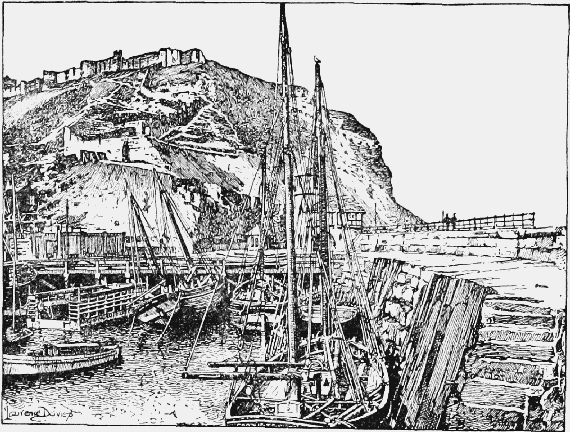
Harbour and Castle, Scarborough
The area is 2,902 a. 1 r. 13 p., including 189 acres of foreshore; (fn. 6) the subsoil is Inferior Oolite and Oxford Clay, the soil limestone, sandstone and clay. The hard stone, in easily separated strata at White Nabb, was used for the early piers. (fn. 7) Lime was once burnt at the Castle Holmes, (fn. 8) and Lime Kiln Hill stands close to Castle Road. In 1601 the corporation leased the saltpans, and in 1616 granted a charter to a company for making salt, with a monopoly for twenty years and the privilege of erecting saltpans on the beach. (fn. 9) There are 244 acres of arable land, 712 of permanent grass, and 50 of woodland. (fn. 10) Falsgrave Common or Moor was inclosed in 1774, Weaponess or Mount Oliver (Wapenesse, xiii cent.) in 1797. (fn. 11)
At the present day Scarborough occupies the neck of a lofty promontory which runs out to sea in a north-easterly direction, the extremity forming the castle rock. The portion of the town along the northern shore is of 19th-century growth, the old town occupying the southern slope. The harbour has always been of importance as the chief shelter between the Humber and Tees. (fn. 12) Remains of the Bronze and Early Iron Ages have been found here. (fn. 13) A 13thcentury manuscript relates how in the 10th century a company of marauding Danes under Knut and Harold, sons of Gorm, defeated Adalbricht son of Adalmund at 'Skardaborg' and marched thence to York. (fn. 14) In 1066 Harold Hardraada in alliance with Earl Tosti, lord of Falsgrave, (fn. 15) seized and burnt the castle, 'took to burn then one house after another, and then all the town gave itself up.' (fn. 16) Scarborough was not mentioned in the Survey of 1086. The earliest settlement, or 'aldborough,' lay beneath the castle near the harbour; it was walled by the time of King John. (fn. 17) The wall ran from a moat on the north, by Auborough and Cross Street, to the sea (fn. 18); from this point the southern wall went east, along Merchants' Row, now Eastborough, to the castle dykes. The castle and its 'scaur' 300 ft. high protected the town on the east. The moat was still traceable on the north in 1798, when the foundations of the walls were still to be seen. (fn. 19) The town had spread westward by the time of Henry III, and this extension, the new borough, was protected by a ditch, (fn. 20) which started from the coast at Huntriss Row, (fn. 21) went north by St. Thomas's Hospital, north-east to Auborough Gate, and east to the foot of the castle hill. (fn. 22) In 1225 the men of Scarborough obtained a grant of forty oaks from the king's wood (fn. 23) and the right to levy tolls on ships for three years towards the defences of the town. (fn. 24) The Dominicans, who were building just outside Auborough wall on the north-west, wanting stone for their church and running water for their workshops, sought leave in 1283–4 to pull down the wall as cumbersome and useless. The burgesses opposed this, as earlier in the century the wall, though old and partly destroyed, had checked the advance against the castle of the enemies of King John and Henry III, who were further thwarted by the Newborough ditch. (fn. 25) The burgesses urged the building of a wall behind the ditch, (fn. 26) and it was probably for this wall that murage for seven years was obtained in 1308 (fn. 27) and throughout the 14th century. (fn. 28) According to tradition the northern part was walled by Richard III (fn. 29) and the whole was in good preservation in the 16th century. (fn. 30) There were gates at Newborough, the entrance from York, a gate 'meatley good,' according to Leland, and at Auborough, 'very base,' (fn. 31) where the remains of a small keep were found in 1806. (fn. 32) Both gates were renewed in 1642. (fn. 33) The Auborough gate disappeared early, (fn. 34) the Newborough gates were in 1843 replaced by a pseudo-Gothic bar, itself removed in 1890.
The old town contains only one main street, called for different lengths along its course, Eastborough, Westborough and Newborough, and from it a series of roads branch off to the north and south. The market hall is modern and of no architectural distinction, but the old market cross, removed from Cross Street, is still of considerable interest. It now stands at the corner of Low Conduit Street and St. Mary's Street. The head has gone, but the shaft is still entire, square below and circular above. The base is ornamented with 14th-century shallow traceried panelling with four ranges of crockets carried up the shaft from the angles. Many ancient houses of various dates remain in the old town, particularly at Sandside. The finest example is perhaps a timberframed structure of the 15th century at the back of the Newcastle Packet Inn. It is now divided into two houses (of which the eastern is No. 2 East Sandgate) and is three stories high. The southwestern angle-post is carved with grotesque figures and a half-obliterated scroll inscription. The other angle-post rests on a carved grotesque, and the framing above is concealed under lath and plaster. In Quay Street are several old houses, of which the Three Mariners Inn has a picturesque brick front of the 17th century with a brick cornice and a series of pediments of the same material over the ground floor windows, each pediment having a rose in the tympanum. (fn. 35) Not far off is an early 16th-century timber-framed house, recently restored. It has a good moulded fascia at the first-floor level, but the herring-bone brick filling is modern. At the corner of Parkins Lane is another example with overhanging stories, and a third at the west end of Quay Street, at its junction with Whitehead Hill, probably dates from late in the 15th century. This is a threestoried gabled building with an 18th-century shopfront to the ground floor and the timbers of the second floor brought out to support the gable. The windows are all later, and the half-timbering is concealed with lath and plaster. On Sandside fronting the harbour is a tall gabled building of 16th or early 17th-century date, built of stone, with modern windows to the front, but in the return wall is a three-light transomed window of Elizabethan character. According to tradition King Richard III stayed here in 1484. On the west side of Dumple Street is a late 16th-century red brick house now divided into tenements numbered 33, 34 and 36. It is two stories high, with stone dripstones or labels over the windows. Of later domestic buildings, the post office on Sandside is an 18th-century gabled building with flush window frames and rusticated stone quoins. Other examples of this date remain in the same street, but the finest will be found at No. 14 St. Nicholas Street. This was formerly a mansion of the Bell family and was built about the middle of the 18th century. It is three stories high and the street front is flanked by two fluted Ionic pilasters rising the full height of the building and supporting a stone entablature with an attic story above. The old town hall (now St. Nicholas Hall) is in the same street and has a modern stone front. A previous town hall lay east of East Sandgate, in Quay Street; it was afterwards used by seamen as a Bethel chapel and in 1874 was purchased by the Wesleyans. (fn. 36) The new town hall stands on the summit of St. Nicholas Cliff. It is built of red brick and stone in the Jacobean style, with Dutch gables. The museum at the foot of St. Nicholas Cliff was founded in 1828 when Hinderwell's collection was presented by his nephew to the Scarborough Philosophical and Archaeological Society. The numerous almshouses of Scarborough have been almost all rebuilt, the only exception being the Merchant Seamen's Hospital, founded in 1752. The buildings are situated in Castle Road, on the north of the old town, and form a quadrangle, open on the south side. They are of red brick and two stories high; in the centre of the north block is a small Doric facade with an entablature and attic, and on the roof behind it is a picturesque wooden cupola. The Trinity House, a stone-fronted building on the south side of St. Sepulchre Street, was founded in 1602, but rebuilt in 1832. In Cross Street is a hospital founded by Thomas Sedman in 1700, but enlarged and rebuilt by Elizabeth Clark in 1811.
Practically nothing is left of the old religious houses of the town, but some idea of their appearance is given in a late mediaeval view in the Scarborough Museum. Of the three friars' houses the Greyfriars' was evidently the largest, the church being represented with a lofty steeple and spire, both apparently octagonal and of the typical form.
The 'Friarage,' in St. Sepulchre Street, marks the site (fn. 37) of the Friars Minor, who held land here in 1245. (fn. 38) The garden on the site of the late Franciscan Priory and other lands of the friars were granted to George Salter and others in 1610–11. (fn. 39) Grey Friars Street is mentioned in the 16th century. (fn. 40) On the map the churches of the White and Black Friars are also shown with smaller steeples. The Carmelite Convent (fn. 41) lay behind the present Queen Street Chapel, on a site given by Edward II in 1319. (fn. 42)
Friars Entry marks the site of the Dominican house founded in 1252. (fn. 43) In 1298 the order received permission to make a street towards their church within the town wall. (fn. 44) This seems to have been Cross Street. Black Friar Gate, now Queen Street, is mentioned in 1611. (fn. 45)
The hospitals of St. Nicholas and St. Thomas the Martyr, both in the new borough, were founded by the burgesses. (fn. 46) In 1298 they held some of their lands, viz., Halgarth in Burtondale, St. Thomas's Meadow opposite the Hall, a grange and garden, and another holding near the new ditch belonging to St. Thomas's, from the commonalty. (fn. 47) There are no remains of St. Nicholas's, which was on St. Nicholas's Cliff, but bones have been found on the site, (fn. 48) and a small brass plate inscribed 'Fr. Wills de Thornton' with part of an inscription on the reverse is now in the local museum. There is also preserved a freestone recumbent effigy of circa 1290 or 1300, found near the West Quay. The figure is armed and has a curious round cap on the head, which rests on a cushion, the hair and moustache being carved flowing. Above it is a cusped and crocketed canopy, and the feet rest on a lion. The shield bears a lion rampant within a bordure, possibly for Brus. The figure is above life size.
Leland mentions St. Thomas's Church as a great chapel beside Newborough Gate. (fn. 49) It was demolished in the siege of 1644. (fn. 50) St. Thomas's Gate changed its name to Tanner Street, but is now again St. Thomas's Street.
There is a park on each side of the Ramsdale Valley, which is crossed by the Cliff Bridge, built in 1827, and the Ramsdale Valley Bridge, opened in 1865. Near the Cliff Bridge is the People's Palace and Aquarium, built in 1877. St. Nicholas Gardens, on St. Nicholas's Cliff, were opened in 1902. The marine drive round the castle was opened in 1908, and the South and North Marine Drives extend for nearly 3 miles north from the Spa. On the north side a promenade pier was built in 1869 and the Clarence Gardens and Royal Albert Drive were opened in 1896.
It is to its attractions as a watering-place that Scarborough owes its modern development. (fn. 51) Its early popularity was as a spa and followed the discovery in 1620 of mineral springs a quarter of a mile south of the town. The first cistern was built in 1698, (fn. 52) a Governor of the Spa being appointed by the corporation. (fn. 53) In 1660–1 'people of good fashion' frequented the Spa. (fn. 54) Defoe in 1727 found 'a great deal of good Company here.' (fn. 55) The Long Room, (fn. 56) 'a noble spacious building with a view for leagues over the sea,' was in 1734 (fn. 57) kept by Vipont, Master of the Long Room at Hampstead. Here were balls every evening, 'when the Room is illuminated like a Court Assembly (and indeed, for the great number of Noble personages present, may very justly be called so.)' Chairs from London plied in the principal streets, and the 'New Inn,' 'New Globe,' 'Blacksmiths' Arms,' 'Crown and Sceptre,' and 'Old Globe' fed 'the Spaws,' as visitors were called. (fn. 58) This Long Room is now the Royal Hotel. (fn. 59) The Spa wells were lost by a serious landslip in 1737, but the waters were speedily recovered. (fn. 60) The Spa was frequently destroyed by the sea before 1839, when the sea wall was built. The large hall then designed by Sir Joseph Paxton was burned down in 1876, but in 1877–8 new buildings were erected. Edward VII as Prince of Wales visited the town in 1869 and again in 1870 and 1871 accompanied by the Princess. The King of the Belgians stayed here in 1873. (fn. 61)
The Jesuit William Lacey (1584–1673) was son of a Scarborough tanner. (fn. 62) Admiral Sir John Lawson, (fn. 63) of whose modesty and wisdom Clarendon wrote, was born of lowly parentage in Scarborough. He lived at the lower end of Merchants' Row. (fn. 64) The Quaker Joseph Oxley was apprenticed to a clock-maker here, and Joseph Rowntree was born here in 1801; Julius Caesar Ibbetson, the painter, was born here in 1759, John Thurston, the draughtsman, in 1774, William Crawford Williamson, the naturalist, in 1816, John Postgate, the food reformer, in 1820, Thomas Joseph Potter, author, in 1828, and Frederick Lord Leighton, whose father was a Scarborough man, in 1830. Other Scarborough notabilities are Sir John Cross (1766–1842), judge in bankruptcy, John Cole (1792–1848), the antiquary, publisher of over 100 rare books, William Bernard Ullathorne (1806–89), Roman Catholic Bishop of Birmingham, Lieut.-Gen. Edward Seager (1812–83), (fn. 65) and Thomas Hinderwell (1744–1825), (fn. 66) town clerk and author of the earliest History of Scarborough. Anne Bronte died at Scarborough, 28 May 1849, (fn. 67) and lies buried in St. Mary's churchyard.
Baker (fn. 68) gives an interesting account of the establishment of Dissent at Scarborough, where Fox was imprisoned and John Wesley frequently preached. The Quakers were numerous here in the reign of William and Mary, and then, as in 1734, their meeting-house was a fashionable place of worship. (fn. 69) The Roman Catholics heard mass in a private house in Westgate until 1809, when a chapel was opened in Auborough. In 1858 Cardinal Wiseman opened the church of St. Peter in Castle Road, which is built in the 14th-century style and has an apsidal chancel. A second church on the South Cliff, Falsgrave, dedicated in honour of St. Edward the Confessor, was opened in 1913. The Congregational chapel in Eastborough was built in 1703 and enlarged in 1774 and 1801 (fn. 70); other chapels of this denomination are at the Bar, opened in 1851, South Cliff (1868), and Manor Road (1898). The Ebenezer Baptist chapel was founded in 1771 and rebuilt in 1827, the Albemarle Baptist chapel dates from 1865; there are Primitive Methodist chapels in St. Sepulchre Street (opened in 1821, enlarged in 1839, and rebuilt in 1856), Aberdeen Walk (1861), St. John's Road (1879), Gladstone Road (1881), Seamer Road (1904), and Claremont United Methodist chapel (1860). The Wesleyans have had meetings here since 1757; their chapels are in Queen Street (1840), Westborough (1886), South Cliff (1886) and Falsgrave (1879). There are also a Unitarian chapel (1877), meetinghouses of the Quakers and Plymouth Brethren, and Salvation Army barracks. The Scarborough Municipal School, erected in 1900, is now a secondary school under the Board of Education.
The first printing-office in Scarborough was established on 'Bland's cliff' in 1734 by Thomas Gent. (fn. 71)
Castle
William de Newburgh, writing at the end of the 12th century, ascribes the building of Scarborough Castle to William third Earl of Albemarle, called 'le Gros' (1127–79), (fn. 72) and it is possible that it may have been begun during the 'anarchy' of Stephen's reign (1135–54). Henry II seized it, and, probably recognizing the importance of its position, completed the work. (fn. 73) Little is known of the history of the castle till the next century. King John, who stayed here on 3 February 1200–1 and 12–13 February 1215–16, (fn. 74) ordered war stores for the castle in 1213 (fn. 75) and in 1216 assigned 100 marks to the keeper, Geoffrey de Nevill, who held it against the barons. (fn. 76) It was one of the five castles committed to Prince Edward in 1265 (fn. 77); the king and his council were here in 1275 (fn. 78) and Edward was again at Scarborough on 27 September 1280. (fn. 79) Welsh hostages were imprisoned here in 1295 (fn. 80) and in 1311 Scottish prisoners who had been captured at Stirling. (fn. 81) Henry Lord Percy, his wife and household had permission in March 1307–8 to live here provided the castle was safely guarded. (fn. 82)
In January 1311–12 Edward II granted the custody to William le Latimer, (fn. 83) but Henry Lord Percy refused to surrender it. (fn. 84) In April the king gave the custody to Piers Gaveston, enjoining him to deliver it to none but the king, nor to him if brought there a prisoner; if the king died he was to retain the castle in fee. (fn. 85) Edward, menaced by Thomas Earl of Lancaster, Henry Lord Percy and Robert Lord Clifford, in May lodged Gaveston at Scarborough, he himself going to York. In spite of orders from Edward (fn. 86) Gaveston was then besieged by Henry Lord Percy and the Earls of Pembroke and Warenne. Gaveston, however, being very short of provisions, surrendered on 19 May, receiving a bond of protection until the ensuing Parliament and a promise that if no agreement could be made he should be replaced in Scarborough Castle. Gaveston was seized by the Earl of Warwick, under Lancaster's orders, and beheaded. (fn. 87) On 31 July Henry Lord Percy's arrest was ordered for his part in this affair. (fn. 88) The king gave an order for the provisioning of the castle in October 1317. (fn. 89) In May 1318 Scarborough, like Northallerton, was sacked and burnt by Robert de Brus and Sir James Douglas. (fn. 90) The loyal burgesses were in 1321 keeping watch and ward in the castle, the king promising that their services should not be made a precedent. (fn. 91) Some of Lancaster's adherents were imprisoned in the castle after Edward's victory at Boroughbridge in 1322. (fn. 92) In 1325 Edward II gave the custody to Eleanor widow of Henry Lord Percy. (fn. 93) Her son Henry, second Lord Percy of Alnwick, (fn. 94) was made keeper in 1328. (fn. 95) The town suffered greatly during the foreign wars of the 14th century, its mariners being slain or imprisoned in foreign parts and its merchandise seized by the pirates of Scotland, Flanders, Zealand and Normandy that infested the coast. (fn. 96) John Mercer, a Scot, had been imprisoned in Scarborough Castle, and his son, with Spanish and French help, in 1378 captured the English ships in the harbour. He meditated greater mischief, but John Philipot, a citizen of London, equipped a fleet, recovered the ships and booty, and took fifteen Spanish ships besides. (fn. 97) According to a petition in Parliament presented in 1379 for vessels of war to be assigned for the protection of the town, French ships were constantly hovering about Scarborough. The townsmen had lost £1,000 in the past two years through captures and ransoms, and many languished in foreign prisons. Consultation with merchants from these parts and London (fn. 98) resulted in the appointment of Thomas Percy and others to guard this coast and in the levying of a subsidy for the purpose. (fn. 99) The Archbishop of York received permission to stay in the castle in 1381. (fn. 100) In 1382 Robert de Rillington of Scarborough was pardoned for treason, including that of leading the enemy by night to inspect the town and castle. (fn. 101) In February 1382–3 inquiry was ordered as to the defensive state of the castle. (fn. 102) In this year 'the poor burgesses and people of the town of Scarborough' represented that, being frequently assailed and injured by the ships of Scotland, France, Flanders and other enemies, the burgesses had bought a barge and ballinger for defence, but could not afford to man them; they desired a commission for the Earl of Northumberland to press men for their service and licence to levy dues for defence on all herrings and merchandise coming in to any place on the coast between Hartlepool and the Humber. They were licensed to take what remedy they thought fit. (fn. 103) A commission of array was issued to the keeper of the castle in 1386 for defence against a threatened French invasion, (fn. 104) and the town was contributing to the defence in February 1388–9. (fn. 105) An inquisition was taken in 1393 as to repairs needed, (fn. 106) and workmen were busy in 1396 and 1400. (fn. 107) All the ships of Scarborough were ordered to be manned in 1398 and to attack the pirates who lay in wait for the merchantmen. (fn. 108) Edward IV granted the castle to Richard Duke of Gloucester, but on the accession of the duke it again reverted to the Crown. With the exception of attacks from pirates Scarborough remained at peace from this time until the later years of the reign of Henry VIII. Richard III dated a precept from the castle on 5 July 1484. (fn. 109) The capture of Scarborough Castle was one of the objects of Hallam's rising in 1536 at the close of the Pilgrimage of Grace; it was, however, surrendered to the keeper, Sir Ralph Eure, without a struggle. (fn. 110) In April 1537 repairs were ordered. Eure told Cromwell in 1538 that part of the wall and its ground in the outer ward, between the gate-house and the castle, had been shot down lately. It was stated that he had made part of the lead of the towers into a brewing vessel. (fn. 111) French war vessels threatened Hull and Scarborough in 1542, (fn. 112) and during the next few years the coast suffered from the French and Scots. (fn. 113) In October 1544 three Scottish ships crossed Scarborough wyke within gunshot, and anchored near so that no one sailing along the coast could escape them. (fn. 114) The town was unable to protect its commerce, as it had only four crayers, under 50 tons, unarmed and not suitable for war. (fn. 115)
In April 1557 Scarborough Castle was the centre of the rising of Thomas Stafford, whose followers held it for six days and then surrendered. (fn. 116) The Earls of Shrewsbury and Westmorland in May 1557 advised preparation against a Scottish attack on Scarborough or elsewhere on the coast. (fn. 117) Hull and Scarborough, the two chief strongholds on the coast, were garrisoned during the Northern Rebellion of 1569, but there was no movement here. (fn. 118) Scarborough added considerably to its revenues by piracy during the reign of Elizabeth. (fn. 119)
Sir Henry Gate the constable wrote to the council about 1587 asking that the ordnance of the castle should be remounted and arms provided, as the place was 'very likely to be aimed at by the enemy,' and the 'affections of divers of the inhabitants' were unsettled. (fn. 120)
In 1619 James I granted the castle to John Earl of Holderness, (fn. 121) younger brother of Sir George Ramsay of Dalhousie. He died childless in 1626, and Sir George Ramsay and others conveyed it in 1630 to Francis Thompson of Humbleton. (fn. 122)
During the reign of Charles I Scarborough suffered greatly from the men-of-war of Dunkirk, (fn. 123) and a Dutch captain defeated a Dunkirk man-of-war in the harbour in 1635. (fn. 124) The Council of the North informed the Privy Council that this harbour was of great importance and that the ordnance in the castle was old, dismounted and useless. (fn. 125) About a fortnight later two Dutch and Spanish vessels entered the harbour to fight, despite the protests of the bailiffs. (fn. 126) Men-of-war were at once sent to Scarborough to apprehend, fire and sink all ships of Holland north of Harwich. (fn. 127)
Charles I, after his retreat from Hull to York in April 1642, (fn. 128) obtained from Scarborough arms for 12,000 foot and 2,000 horse, landed from Holland. (fn. 129) Towards the end of August Sir Hugh Cholmley of Whitby (q.v.), after some hesitation, agreed to garrison Scarborough for the Parliament. Cholmley had represented Scarborough in the Short Parliament, and in November 1641 had refused to pay ship-money, but, though one of the commissioners appointed to treat with the king at York, he thought the Parliament's propositions 'most unjust and unreasonable.' (fn. 130) On 20 March 1643, however, he left the castle, ostensibly to meet the Governor of Hull, but actually rode to York, where he took the queen's commission to hold Scarborough Castle for the king. On 25 March Sir Hugh announced his change of sides to his officers, letting the Parliamentarians depart. He himself left for York, entrusting the castle to his kinsman James Cholmley. Two officers, Captain Bushell and his brother, persuaded the soldiers to seize the castle for the Parliament, 'which, tho' able to hold out against an army of 10,000 men, was thus twice taken in one week, without shedding one drop of blood.' (fn. 131) Sir Hugh Cholmley was impeached, and the Governor of Hull sent £20 for drinks for the garrison. (fn. 132) Captain Bushell shortly afterwards restored the castle to the Royalists. (fn. 133) Sir Hugh Cholmley returned as governor and commissioner for maritime affairs from the Tees to Bridlington. (fn. 134) He and his wife lived here 'in a very handsome port and fashion,' without 'the worth of a chicken out of the country,' or any fee. (fn. 135) After the battle of Marston Moor in July 1644 York surrendered to the Parliamentary forces, and the Earl of Newcastle, the king's general in the north, fled to Scarborough. Cholmley furnished him with a ship, but refused to leave unless compelled by force or royal command. Most of the gentry and many foot soldiers deserted, leaving Cholmley 'in a very sad condition, for the town by situation was not tenable, the castle ruinous, without habitation or provisions, or ammunition considerable,' and Fairfax with a large army was near. He accordingly opened negotiations for surrender, and thus gained time to put the castle in a state of defence which enabled him to hold out for twelve months. (fn. 136) On 18 February 1644–5 Sir John Meldrum took the town with the loss of eleven men, capturing eighty soldiers and the governor of Helmsley Castle, who held the church. Cholmley retreated to the castle, but Meldrum seized 120 ships in the haven and cut off Cholmley's retreat by sea. (fn. 137) The only Royalist port on the east coast thus came into the hands of the Parliament, (fn. 138) but by May Cholmley had recovered its control. (fn. 139) On 25 July 1645 the castle surrendered on favourable terms to Sir Matthew Boynton, the garrison being worn out and the whole north in possession of the Scots and Parliament. (fn. 140) Sir Hugh Cholmley distributed nearly all his money among the garrison and took ship for Holland. (fn. 141)
In June 1646 the Committee of Both Kingdoms ordered fresh ammunition to be sent to Scarborough, where Newcastle had designed to land and raise Yorkshire. (fn. 142) In July 1648 the governor, Colonel Boynton, declared for the king. (fn. 143) After a vain attempt to come to terms, (fn. 144) Colonel Bethell besieged and took the castle, which was well stored with provisions and ammunition. (fn. 145) £5,000 was voted for repair of the works, (fn. 146) and in July 1649 the Council of State ordered the castle to be demolished and works built on the platform for the security of the harbour. (fn. 147) In January and February 1650–1 various disaffected persons were removed from the town and the advisability of changing the garrison was considered. (fn. 148) In June, however, all orders concerning the castle were suspended, (fn. 149) and the appearance of the Dutch in the harbour necessitated an increase of the garrison. (fn. 150) On 7 April 1653 (fn. 151) De Witt with eighteen sail and two hoys sailed into Scarborough bay. The coastwise colliers had taken refuge here and crowded as near the shore as possible, protected by nine men-of-war, guns on the pier-head and six guns elsewhere. The enemy sailed in, fired twenty guns and then stood off; the collier fleet proceeded under convoy. (fn. 152) On 18 April the collier fleet again put in, the convoy being too weak to engage a fleet of Flemings. (fn. 153) Peace was concluded with the United Provinces in 1654; in July 1655 the garrison was ordered to be entirely reduced, (fn. 154) but was shortly afterwards restored. Until the end of the Protectorate North Sea fishers and colliers frequently took refuge here, prizes were chased into the harbour, and Dunkirk prisoners lodged in the fortress. (fn. 155) The castle was repaired and furnished with military stores, and the garrison was increased in 1658. (fn. 156)
At the Restoration the town was described as populous, factious and needing a garrison. The castle, which it was suggested should be made the magazine for the North Riding and Durham, (fn. 157) was in 1662 sold by William Thompson to the Crown, (fn. 158) which in the same year granted the site to William Whitmore and Edmund Sawyer. (fn. 159) William Saxby was concerned with it in 1695, but from 1670 or earlier it was in the hands of the Crown. (fn. 160)
Various political prisoners were kept here during the next few years, (fn. 161) including James Berry, one of Cromwell's favourite generals (fn. 162); John Joplin, gaoler of Durham during the Commonwealth, 'a furious Fifth Monarchy fanatic' (fn. 163); and George Fox, the founder of the Society of Friends, who was removed here from Lancaster in April 1665. (fn. 164) He was put into a room where the chimney smoked and into which the rain came, and after he had spent 50s. on repairing it they moved him into a worse room, without a fireplace. He was badly treated in other respects, but was discharged on 1 September 1666. (fn. 165)
The town continued to be of military importance, and was kept in a state of defence until the treaty of Nimeguen in 1678. (fn. 166) James II did not garrison it in 1688, and it was represented that a good officer and two companies of militia would be sufficient to hold it if the Dutch descended on the Yorkshire coast. (fn. 167) On 1 December the Earl of Danby wrote to the Prince of Orange that he had seized the castle, which contained a very good magazine, and put in a garrison. (fn. 168) The persistent Jacobites in Scarborough were, with some exceptions, pardoned in 1690. (fn. 169) Arthur Viscount Irwin was appointed governor in 1694. (fn. 170) It was some eighty years before Scarborough again heard the rumour of war. On 23 September 1779 Paul Jones entered the bay, and beneath the walls of Scarborough Castle attacked and defeated two men-of-war which were acting as a convoy to a fleet of merchant vessels. (fn. 171) During the American war Scarborough had occasionally 400 foot soldiers, besides a Volunteer corps raised in the town. In 1794 five companies of Volunteers were raised for its defence. (fn. 172) The barracks are now used as a dépôt.
Scarborough Castle stands between the north and south bays on a rocky promontory, crowned by a triangular plateau about 19 acres in extent, and having its longest side towards the east, where the hill falls precipitously to the sea. On the south-west, towards the harbour and town of Scarborough, the sides of the hill are less steep and are skirted at their base by a wide ditch; the north-west side, which has no ditch, resembles the east side in character, but is lower, and the sea does not reach to its base, as was the case on the east side before the formation of the present Marine Drive. The plateau was inclosed by a curtain wall, with towers and turrets placed at intervals, extending the whole length of the southwest side, and about half the length of the northwest side; the remainder of this and the whole of the eastern side are rendered sufficiently impregnable by the sea and the precipitous nature of the hill. The keep stands within its bailey at the western or landward angle of the plateau, which is also its lowest and weakest point, and overlooks the narrow ridge which forms the only approach to the hill. Upon an outlying spur of this ridge is placed the barbican, which itself forms the first ward, and is connected by the bridge with a second ward without the curtain wall, adjoining the bailey on the west. Within the enceinte to the north of the bailey, and entered from the north-east angle of the second ward, there appears to have been a third ward, which has completely disappeared, from the south side of which the bailey must have been entered.
The outer ward occupies the whole of the remaining area of the plateau, and is divided from the bailey by a wall and ditch. Of the lord's hall and other buildings which stood within the bailey nothing now remains, the only surviving traces of the domestic portions of the castle being the foundations of a hall with a great chamber and offices at the southwest of the outer ward, excavated in 1888, and the barracks built against the south-west wall near the middle of its length, which occupy the site, and probably incorporate parts of the structure of Mosdale Hall, or the King's Hall. St. Mary's chapel, which also stood in the outer ward, has completely disappeared, but the site of the graveyard, as also of our Lady's well, which was situated close by, can be located. Much light is thrown on the original arrangements of the castle by a survey made in 1538 by Sir Marmaduke Constable and Sir Ralph Ellerker, (fn. 173) and some information as to the dates of the various parts may be gleaned from the extant Exchequer accounts dealing with expenses of works at the castle. The materials of the whole of the works are limestone rubble, quarried from the castle rock, for the core of the walls, with sandstone for the facing and wrought work. The latter stone was quarried both from the castle rock and from 'Whallesgrave' (Falsgrave) and Hayburn.
The date of the keep is fixed by a series of payments entered on the Pipe Rolls from 1158 to 1164. (fn. 174) Three of these entries refer specifically to the 'turris' or keep, while the other payments are described generally as 'in operatione de Scardeburc,' or 'in operatione castelli de Scardeburc.' The total sum accounted for amounts to £593 15s. 8d., and of this sum £131 3s. 8d. was spent on the 'turris.' The remainder, it may be supposed, was expended on the construction of the still existing walls inclosing the site. The walls, however, do not appear to have been anything like completed till the early 13th century, as in 1212 and 1213 sums amounting to £1,322 12s. 8d. were expended. (fn. 175) An inquisition on the state of Scarborough Castle made in 1260 is valuable for the list of the various buildings which it contains. Among other parts of the castle, mention is made of 'the hall within the inclosure of the tower,' which is described as being wholly uncovered and in a ruinous condition. The battlements and alure of the castle wall towards the town needed great repair, and the flooring of three turrets in the enceinte of the castle walls was uncovered in several places, while the battlements and alure of the outer barbican were in great part thrown down and injured. (fn. 176) The greater part of the original curtain wall inclosing the site remains, though patched, repaired, and refaced in many places. The barbican in its present state probably dates in the main from the latter years of the 13th century.
The great bridge is known to have been rebuilt in 1337–8, (fn. 177) and the present structure agrees with this date. The north-west wall of the ward between the bridge and the bailey must be almost entirely modern, as in the survey of 1538, above referred to, this portion is said to have been 'in decay and fallen down,' and it is further stated that 'by estimacion of masons no wall can be sett agayne but if it be upon an arche or archis of stone'—an expedient found necessary in its modern rebuilding. The southern wall of this ward, which leaves the bridge at an angle and joins without bond a turret of the curtain wall, may be that referred to in the following entry in an account of 1428: 'in the wages of ij masouns Wirking . . . upon the makyng of a newe walle fro the Watchehous to the brigge of the said Castell.' (fn. 178) It is possible that before this time a narrow causeway leading to the gate of the bailey crossed the site of this ward, the existence of which may go no further back than the date of the building of the south wall. The tower upon which the wall abuts commands a wide view to the north, west, and south, and is excellently adapted for the purposes of a watchtower.
The few moulded details brought to light when the foundations of the hall at the south-west of the outer ward were excavated show it to have been of the latter part of the 12th century. No mention is made of it in the survey of 1538, but at what time it was pulled down is uncertain. An account roll for 1319– 20 (fn. 179) refers to repairs to a 'vetus aula,' a 'media aula,' and an 'aula in curia.' By the first term is possibly meant the hall in the bailey which has now disappeared, while 'media aula' may refer to the foundations above mentioned, 'aula in curia' being perhaps used to distinguish a hall which stood a little distance to the south-east, on the site of Mosdale Hall, or King's Hall, against the south-west wall of the outer ward. This last hall was rebuilt by John Mosdale, the governor of the castle, at the end of the 14th century, and was converted into barracks in 1745. It is probable that the original external walls were made use of, though now refaced everywhere with brick, as the lower courses of the original masonry, both of the main structure and of the tower at the north-west, are visible on the outer side, and the core of the walls appears to be of stone wherever the internal plastering is removed. The survey of 1538 gives the following description: 'The sayd Mosdale hall (fn. 180) is of two stories heght—in lenght xx yardys and di– in brede viij yardys . . . and in the south ende of the sayd hall is a lodgynge joyned to it of thre stories heght in lenght ix yardys and di. of lyke brede as the sayd hall.' The barracks as they exist at the present day, though outwardly uniform in elevation, consist of two distinct portions, without internal communication. The northern portion measures internally about 62 ft. in length and 28 ft. in width, the length of the curtain wall included within it being 8 ft. 4 in. thick, while the wall towards the outer ward is 5 ft. thick. The ground stage of the tower at the north-west contains a small chamber, which, unlike the rest of the building, seems to have been left more or less in its original condition, save for the insertion of a sash-framed window. The southern portion, the walls of which are thinner, the outer wall being 6 ft. 6 in. thick, the normal width of the curtain wall elsewhere, and the wall on the side towards the ward 3 ft. 8 in. thick, measures 30 ft. 8 in. in length and 30 ft. 2 in. in width. It will be seen that with the exception of the breadth these measurements do not differ much from those of the survey, while the division into two parts is still distinct. The semicircular tower to the northward of Mosdale Hall was known as the 'Queen's Tower,' and adjoining it on the inside must have been the 'camera regine' to which important repairs amounting almost to a rebuilding were made in 1320, (fn. 181) while at the same time a porch with a stone foundation was added to it. There are frequent references in subsequent account rolls to repairs of various descriptions to both the Queen's tower and the Queen's chamber, and the tower is described in 1538 as having been at that time four stories in height, 6 yards in length, 5 yards in breadth and 12 yards in height.
The curtain wall on either side of the second of the two large mural towers to the south of Mosdale Hall appears to have been set back with the tower itself and the adjoining solid turret, as there is a marked inward bend to the south of the latter. Possibly an explanation is to be found in an account roll for 1425–9, (fn. 182) which records that the 'Constable's Tower whilk was in poynt to fall' was taken down, and that payment was made to 'Thomas Hyndley, (fn. 183) meistre mason, for ryding fro Duresme to Scardeburgh for to devyse and ordeine the moste siker grounde of the Constable toure before saide.' Mention is also made of the 'rydding and takyng of a newe grounde of a walle beside the Constable toure.' The tower is described in the survey of 1538 as 'of ij stories heght rounde—vj yardys wyde.' To the south of this point is about 100 ft. of thinner walling, probably a late rebuilding, as in 1538 a third tower is described as existing 30 yards to the south of the solid turret, and the wall between is said to have been of the same thickness as the other portions of the curtain wall. The southernmost tower of this wall, which stood upon the edge of the cliff, and was known variously as Cockefelde, Cockhyll, and later as Charles's tower, has also disappeared. Below the site of the latter is the South Steel battery, which was made in 1643. It is approached by a doorway in the curtain wall, opening on to a stepped path leading down the steep slope of the hill, and protected by a wall on the west side.
The barbican stands on a small hillock overlooking the steep approach from the town. The inclosure, the shape of which is governed by the nature of the ground, is roughly triangular, with the base towards the south, and measures about 130 ft. from east to west and 50 ft. from north to south. The gateway, flanked by large semicircular turrets, is placed at the east end of the south side, the lower level of the ground here allowing of a sufficient height to the wall and turrets without the necessity of carrying them above the general level of the top of the curtain wall, to the west, where the ground within the inclosure rises in places nearly to the level of the alure or rampart. The north and east walls are mere parapets, the former being placed on the edge of a sharp descent. The walling generally, as elsewhere, is of limestone rubble for the core and a yellowish sandstone for the facing, much of which has been renewed. The gateway has an outer segmental arch of two chamfered orders carrying a thin wall, the space between this and the inner arch, which is of the same form, doubtless serving as a meurtrière or opening by which the gate could be defended from above. The jambs of the entrance have been repaired in such a manner that no trace is left of the grooves in which the portcullis must have worked. In the turret to the west of the gateway was in 1538 the porter's lodge, of 'oon story heght covered wythe leade,' but this, like the other turret, is now only a shell. In the wall over the outer arch is a square niche, and set in the south-east face of the wall of the western turret is a fine 15th-century shield of France and England, much decayed. There is a crowning string-course and plain parapet, probably of late date. The curtain wall to the west has two smaller semicircular turrets, one being placed at the south-west angle of the barbican, and the other midway between it and the gateway. Internally the alure, with steps leading to it behind the middle turret, can be distinctly traced. The east wall is crowned by modern battlements. A doorway at the west end of the barbican, now blocked, was made in the 17th century to communicate with a battery which was formed at that period to the west of the barbican.
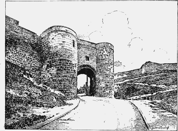
Scarborough Castle: The Gateway
The bridge joins the barbican at its north-eastern angle, and is approached from the gateway by a sloping roadway sunk a few feet below the level of the surrounding ground. In its original state the bridge, which runs in a north-easterly direction, consisted of a massive central pier, crowned by a gate-house flanked by large semicircular turrets, with drawbridges on either side working between stone spandrel walls carried by segmental arches of two chamfered orders. It was further protected by smaller turrets flanking the abutments towards the barbican and towards the second ward. The pier and abutments have deep chamfered plinths of three offsets, and the former has triangular starling-like terminations changing to a semi-octagonal form a little below the spring of the arches of the spandrel walls, above which originally rose the semicircular turrets of the gate-house, but only that on the south now remains. The two turrets of the abutment on the outer or barbican side are carried in a similar manner; the abutment on the side towards the second ward has now only one turret remaining on the southern side, which is carried by a pointed arch thrown between the heads of a pair of buttresses of two offsets set at right angles to each other. Both pits have been vaulted over between the spandrel walls to carry the present roadway, the arches on the barbican side having been wholly renewed, but the northern spandrel wall and arch of the pit on the side towards the second ward is still in its original condition, though a storehouse has been formed beneath, the wall of which now entirely conceals the southern arch. The surviving turret of the gateway is filled with masonry, but part of a vice which must have led to an embattled walk over the gate still remains; the corbels which supported the projecting embattled parapet of the turret itself are also in position. The gateway is described in the survey of 1538 in the following terms: 'wythyn ye same (the bridge) a turrit in lenght ix yardys and di., in heght xiij yardys, in brede v yardys,' and mention is made of a portcullis, the arrangements for which have completely disappeared. The whole work is faced with sandstone, and beneath the central pier on the north side is a mass of limestone rubble upon which it partly rests, probably a fragment of the bridge which it replaced.
The second ward originally included a triangular area measuring about 150 ft. by 130 ft., its greatest length being from north to south. The east side was bounded by the western portion of the original curtain wall, but only the foundations of this remain, the second ward and the bailey being now thrown into one. The roadway leading through the ward from the bridge to the site of the gate of the third ward at the north-east ascends sharply along the northern and lowest side of the neck of land on which the ward is placed, the wall here, as mentioned above, being almost entirely modern. The south wall, which is carried along the edge of the higher side of the site, ascends steeply from the bridge to the curtain wall, where it abuts upon a solid turret (probably the 'watch house' of the account roll) which has lost its upper story. From this turret access was gained to the stepped alure of the wall, and so to the bridge and barbican, by a small doorway, the lower jamb stones of which can still be seen. In the eastern portion of the wall are five arrow slits, two of them perfect and splayed to allow of a downward aim. Near the junction of the wall with the bridge is a blocked pointed opening, probably a postern. The masonry is of limestone rubble, and there is no bond between the wall and the turret, which is faced with sandstone ashlar and has a deep stepped and chamfered plinth. The facing of the wall on the ward side seems to have fallen away in parts, and the western portion is supported by large modern buttresses. At the northeast angle of the ward was a gateway to the third ward, the walls of which have completely disappeared. This ward is described in the survey of 1538 in the following terms: 'Fyrst at th' entre of the thyrde warde is neyther tower ne house but a payre of evyll tymbre gatis of xiij fote heght and x fote brode, and a place for a port-cules . . . and the sayde warde is square like unto a courte, xxij yardes.' The chief function of this ward must have been to afford communication to the outer ward from the bridge and second ward, without the necessity of passing through the bailey. At the south-east appears to have been a gate to the outer ward, traces of the south jamb of which are still left. The line of the wall dividing the ward from the bailey can be traced for a few feet from this point, but nothing remains to show the position of the gate to the bailey, which was probably near the east end of this wall. Against the curtain wall, which forms the west side of the ward, are 18th-century buildings and offices, and at the north end, on the outer face, are some original buttresses.
The bailey is of irregular shape, and measures about 290 ft. from north to south and 160 ft. from east to west. The keep, which stands at the northwest, close upon the probable lines of the north and west walls, is a square building, each side measuring externally about 55 ft., and was three stories in height above the basement. The east wall, with the greater portion of the north and south walls, is still standing to a height of about 80 ft., but the west wall has all gone above the basement. The north, east, and south walls are respectively 10 ft., 10 ft. 6 in., and 11 ft. 6 in. thick, while the remaining portion of the west wall, which contained a newel stair 12 ft. in diameter, is 15 ft. thick. The walls have a core of rough limestone, quarried from the castle hill, and are faced with sandstone of the same character as used elsewhere for wrought work. The stones of the facing have joints of from 1/8 in. to ½ in. in depth, and show, where original, 12th-century tooling. The elevations were of a regular and normal type with clasping buttresses on the north, shafted at the angles, and pilaster strips in the centre of the east, north, and west faces, all rising without base mould from a deep battering plinth about 6 ft. high, standing upon three chamfered offsets resting upon a vertical face. The south face has no pilaster strips, nor are the wide buttresses at the south end of the east and west walls returned as clasping buttresses, though the angles are shafted as on the north; the plinth only exists for about 9 ft. at the west end, the remainder of this face having been covered by a forebuilding protecting the entrance. Each angle appears from the survey of 1538 to have been capped by a turret in the usual manner, the forebuilding, described as the fifth turret, being 'tabled wyth stone.' On the east face, which remains nearly perfect, the third floor is lighted by two pairs of round-headed windows, each of two square orders, and the second floor by two windows, each having a plain round-headed containing arch inclosing two lights with round roll-moulded heads which spring from central coupled shafts with scalloped capitals, and are received upon single jamb shafts of the same form. Similar windows appear to have lighted the first floor, but these are now blocked, and only the containing arch is visible. The windows in the north and south walls were of like character; the basement is lighted only by two loops in the north wall.
The inner entrance is at the west end of the south side of the first floor, and consists of a vaulted passage through the thickness of the wall, 7 ft. 6 in. in width, having a semicircular arch on the internal face and a segmental arch on the external face, each of one plain order. About half the passage forms a short lobby on a level with the first floor, the remainder containing a short flight of steps leading up from the outer door. This entrance was covered by a forebuilding 27 ft. long and projecting 22 ft., of which nothing remains but the basement, which formed a prison pit with an attached garderobe below the main stairs. Some toothings projecting from the south face of the main building are sufficient to show that the height of its flat roof was 39 ft. above the plinth of the keep, and on a level with the second floor, from which access was gained from a mural recess in the south wall by a narrow round-headed opening. The outer door was 9 ft. broad, and its head sprang from a scalloped corbel 4 ft. broad upon the south wall of the keep; behind this was a large V-shaped meurtrière. A flight of steps, 9 ft. broad, started from the south-east angle of the keep and led up at one stage through the forebuilding to the sill of the inner door. These steps have been altered and raised for a few feet outside the outer door. There are no traces of a portcullis in the forebuilding or in the keep, but the main entrance to the latter had a bar-hole on the west, now blocked. The upper floor of the forebuilding, which was reached by a narrow right-angled mural stair starting from the first floor of the keep, to the east of the main door, had a small round-headed locker in its north wall just above the meurtrière.
The basement of the keep was a plain chamber about 28 ft. 6 in. by 25 ft. 6 in. The two loops on the north side have stepped and splayed sills. In the west wall was a door 5 ft. wide, leading by a short lobby into the great staircase. There are no springers of any kind on the walls, and the floor of the story above, as of all the upper stories, must have been of timber. The first floor, which measured internally about 32 ft. by 28 ft., seems to have been divided into two bays by a great arch from north to south, 28 ft. in span and 4 ft. 6 in. in width, carrying a cross wall to the floor above. Only fragments of the springing stones and the plain pilasters, 2 ft. in depth, which formed its responds, remain. Between the two windows in the east wall, which are placed in straight-sided recesses, now walled up, and have semicircular rear arches, is a round-backed fireplace with a semicircular head and a flue carried up in the thickness of the wall. The eastern of the two north windows is blocked, like the windows in the east wall. At the south-east is a small doorway opening into a chamber in the thickness of the wall, lighted by a narrow loop on the east. The arrangement of the east wall at the second floor level is like that of the floor below; the fireplace, however, has a segmental head with a semicircular relieving arch above. The windows are in their original condition, and the lights have internal shutter rebates with pointed heads. On the south wall the jamb of a doorway through the cross wall remains, and from further indications at this spot it would appear that the cross wall on this floor was lightened on each side by a series of arched recesses separated by a thin stone screen. At the north-east of the eastern of the two rooms into which this floor was divided is a doorway to a chamber in the thickness of the wall, lighted by a loop on the east; to the west of this, close against the former northern end of the cross wall, is a doorway to a mural passage which probably led into the western chamber, and passed below the window lighting this chamber on the north, which has been lengthened and its recess opened down to the floor of the mural passage by removing the roof and south wall of the latter. At the south-east of the eastern chamber is a doorway opening into a mural chamber corresponding to that in the north-eastern angle, while immediately to the east of the cross wall is a round-headed recess containing two loops at different heights, of which the western and lower has served as a doorway to the roof of the forebuilding. The greater part of the south wall of the western chamber has gone, but the east jamb and part of the head of the window which lighted it from this side remain. The third and highest floor, which had no cross wall, had as stated above two pairs of coupled round-headed lights on the east and south respectively, each pair having a common recess and rear arch. In the north wall were also two recesses, the eastern containing a window of the same type, but that on the west must have been blind, or with but one light, on account of its unsymmetrical position with regard to the pilaster strip outside. No traces exist of the roof itself, but it must always have been flat, for there are no remains of gabled weather mouldings.
In the thickness of the west wall, at its south end and at about 3 ft. above the first floor level, are slight traces of a mural chamber with fragments of a hearth. This wall probably contained a number of apartments, and certainly among these were the garderobes, for the remains of four shoots are to be seen on the western battering plinth, arranged in pairs between the pilaster strips. There are no traces of a well anywhere within the keep or the forebuilding. The workmanship throughout, though plain, is of the highest quality and precision.
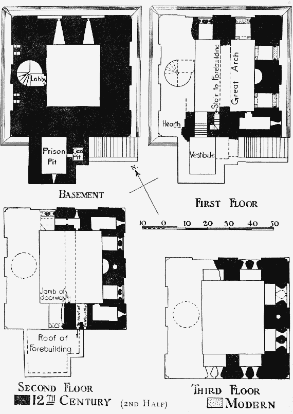
Scarborough Castle: Plan of the Keep
To the south of the keep, and parallel with it, are the foundations of a small outbuilding, which seems to have been originally joined to the forebuilding by a wall. At the south-west of the bailey is the recently reopened well, which is lined with masonry to a depth of about 68 ft., and below this level is driven down through the rock a further 109 ft. The curtain wall, which forms the south-west boundary of the bailey, runs nearly due south from the tower upon which the south wall of the second ward abuts to another solid semicircular turret which is now used as a beacon. The exterior face of this turret, with that of the greater part of the adjacent walling, has been refaced. From this point the wall takes a turn to the south-east and continues in this direction for the whole of its remaining length. To the south of the beacon turret is another solid turret of the same form, which retains part of its deep chamfered and stepped plinth, much weathered and decayed. The outer face of the wall between this and the next turret, an angular three-sided projection upon which the east wall of the bailey terminates, has three pilaster buttresses of original late 12th-century date, standing on a deep battering plinth of four chamfered courses. On the inner face of the wall, between the beacon turret and the next turret to the south, the position of the steps to the alure can be clearly traced. Both wall and towers are of limestone rubble partly faced with sandstone, and in the absence of wrought detail little more can be said than that the wall and three southern turrets belong probably to the works executed between 1154 and 1213. The northern turret, the 'watchhouse' of the accounts, looks like a 14th-century rebuilding, and part of the work to the south of it is refaced with the same stone. The east wall of the bailey, dividing it from the outer ward, is of limestone rubble, much patched and repaired, the southern portion being a late rebuilding above the foundations. At its northern end, on the bailey side, pockets to receive the ends of the rafters of pentice roofs remain.
The foundations excavated at the south-west of the outer ward in 1888 are those of a building measuring externally 100 ft. 9 in. by 54 ft. 6 in., and placed with its greatest length in a south-easterly direction. (fn. 184) This may be, as suggested above, the 'media aula' of the account rolls; the jamb of an enriched doorway found on the site shows it to have been of the latter half of the 12th century. The principal apartment seems to have measured internally 51 ft. by 47 ft., and to have had a low stone seat on the west side, opposite which was an L-shaped platform of rough stone. At the north-east end of this room or hall were found the jambs of the doorway above referred to. At the south-east was a large room 21 ft. by 47 ft., while at the opposite end were two small chambers, each 18 ft. by 12 ft., and divided from each other by a passage which probably led from the hall to a kitchen on this side, parts of the foundations of which have been uncovered. The portion of the curtain wall which forms the south-west side of the outer ward has four large towers and two small solid turrets, all semicircular, with the exception of the octagonal tower attached to the north-western end of Mosdale Hall, which is now faced with brick. The northern tower, formerly known as the Queen's tower, has been much repaired externally, and like the other semicircular towers has been gutted internally and razed to the alure level. The wall between this and Mosdale Hall has on its outer face three buttresses, each of two offsets with deep chamfered plinths, which suggest a 14th-century rebuilding. Between Mosdale Hall and the northern of the two remaining towers, which may be of the 14th century, is a small solid turret; the wall on either side of it has been largely refaced, and has buttresses of about 1 ft. 10 in. projection, with shallow offsets near the top, alternating with pilaster buttresses of about 8 in. projection, the latter probably of original 12th-century date. About midway between the two southern towers is a blocked opening in the wall, to the south of which there is a marked change in the masonry, and the direction of the wall bends slightly inward. The southernmost tower, perhaps, as suggested above, the Constable's tower of the account rolls, has been entirely refaced and the upper part rebuilt; the wall from this point to the southernmost of the small turrets gradually sweeps outward again to the general line, but has been almost wholly rebuilt above the lower courses, so that there is little to judge by, besides the line of the foundations, in determining the date of the wall and tower. Beyond this point is the length of thin walling noticed above, and beyond this again a portion of original walling with buttresses of uncertain date, extending to the site of Cockbill or Charles's tower on the edge of the hill overlooking the sea, below which is the South Steel battery. On the side towards the ward the facing of the wall is nearly all gone. The Queen's tower and the tower to the south of Mosdale Hall retain the internal jambs of blocked loop recesses.
Borough
Henry II, before 1163, (fn. 185) granted to the burgesses of Scarborough all liberties enjoyed by the citizens of York, paying to the Crown as gabelage from each house 4d. or 6d. according as the gable or side faced the street. (fn. 186) The town paid as farm in 1163–4 (fn. 187) £20, afterwards increased to £30, and a further £4 was exacted in 1175–6 (fn. 188). It remained at this figure for some time, but in February 1200–1 the king granted the men of Scarborough the towns of Scarborough and Falsgrave, the mills and other appurtenances at 'the old farm,' viz., £33 from Scarborough and £10 from Falsgrave with its appurtenances, and £33 increment. (fn. 189) In 1202 the town paid £10 from Falsgrave, £33 as their ancient farm, £33 increment, and £20 fine for having their town. (fn. 190) In 1253 the fee farm was fixed as £66, payable by the burgesses' hands, (fn. 191) and three years later that of Falsgrave was fixed at £25. (fn. 192) In the early 14th century the farm was £91, and Edward II exacted a further £66 (fn. 193); allowance was finally made by Edward III for the amount paid in excess of the farm. (fn. 194) In 1391 the queen held the farm in dower, (fn. 195) and in 1450 Henry VI remitted nearly half the sum. (fn. 196) Henry III in 1253 twice confirmed the charter of Henry II and granted further liberties (fn. 197); two additional charters were obtained in 1256. (fn. 198)
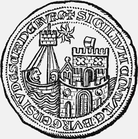
13th-Century Seal of the Borough of Scarborough
In 1273 the burgesses assaulted the constable of the castle, and the town was taken into the king's hands, (fn. 199) but restored in 1276, the burgesses paying a fine of £40. (fn. 200) In March 1311–12 the charters were confirmed. (fn. 201) After the death of Gaveston the town was taken into the king's hands, the constables of the castle being its keepers. (fn. 202) Scarborough was particularly unruly during this period. In March 1313–14 inquiry was ordered into an assault on the king's servants and the seizure of timber provided for the repair of the houses in the castle. (fn. 203) Next year the men of the town complained that the keepers forcibly took their goods without payment; they vainly begged to have their town at farm again. (fn. 204) Many of the burgesses broke out into open revolt in 1316. Twenty-three persons banded themselves together apparently to carry on a provisional government in spite of the Crown, whose ministers they refused to acknowledge. (fn. 205) They assaulted Robert Wawayn, the royal bailiff, and prevented his exercise of his office while they collected the dues. (fn. 206) He and the town clerk were besieged in 1319, (fn. 207) when Wawayn's temporary removal seems to have quieted the town. The burgesses again vainly petitioned in 1324 for the restoration of their town at farm, quayage, pavage and murage. (fn. 208) Special protection was granted in this year to the royal keepers and to William de Willerby while suing for the Crown against the men of Scarborough for 'trespasses and contempts' against the king and his ministers. (fn. 209) In February 1324–5 men of the town were charged with assessing tallages on their own authority and levying other sums and with fishing in the king's stews at Scarborough. (fn. 210) Immediately after the accession of Edward III Scarborough was restored to the burgesses. (fn. 211) In February 1348–9 the charters of the town were inspected and confirmed, (fn. 212) and in 1356 part of an ancient custumal was ratified. (fn. 213)
The charters were confirmed in 1377. (fn. 214) An inquiry was ordered in 1378 as to dissensions at Scarborough, and the Earl of Northumberland was ordered to put the town in a state of defence and to appease the strife, 'saving the liberty' of the town. (fn. 215) Northumberland and others were commissioned in 1381 and 1382 to suppress unlawful assemblies in and about Scarborough, where the rebels assumed a livery of white hoods with red tippets. (fn. 216) On the suppression of these revolts Scarborough was pardoned on payment of 400 marks (fn. 217); but in 1383 the Commons petitioned in Parliament on behalf of the burgesses and people of Scarborough, many of whose franchises had been taken away, rendering them incapable of supporting public charges; the liberties were restored. (fn. 218) Robberies and the breaking of the king's prison were reported in 1384. (fn. 219) In 1391, at the supplication of the queen, the burgesses were pardoned all trespasses and conspiracies of which they had been indicted. (fn. 220) The charters of the town were confirmed in 1400, (fn. 221) 1414, (fn. 222) 1423, (fn. 223) 1492, 1510, 1547, 1554, 1560 and 1608. The constitution was altered in 1485 and in 1684, but the older system was restored in both cases after a few years. (fn. 224)
Edward IV in 1472 granted, in exchange, the castle and lordship of Scarborough, the fee farm of the town and borough with the port and haven and fee farm of Falsgrave to Richard Duke of Gloucester and Anne his wife and her heirs (fn. 225); with Richard's accession Scarborough returned to the Crown.
The charter of 1253 confirmed to Scarborough its gild-merchant, but there is no evidence as to its connexion with the government of the town. The customs, confirmed by Letters Patent of 1356 and ascribed to the reign of Henry III, describe a constitution similar to that surviving in 1835 under the title of 'The Bailiffs and Burgesses of the Town of Scarborough.' (fn. 226) In 1356 all the commonalty of the town assembled on Michaelmas Day or St. Jerome's Day (30 September) at the common hall for the elections; by the 19th century only the bailiffs and members of the common council attended on the latter date. From this assembly the majority elected two coroners; they nominated four first electors, who co-opted eight of their fellows. These proceeded to elect from the council a senior and junior bailiff. The bailiffs acted as justices of the peace and as judges of the Court of Pleas and of Admiralty, &c., receiving as their dues the petty tolls. The chamberlains were chosen in the same way as were the bailiffs. The common council or 'House' was divided into three sets of twelve persons and was filled yearly. At a date fixed by the bailiffs all the council met; each bailiff appointed six 'factores' from the chamberlains and second and third twelves. These 'factores' chose and arranged the first twelve for the year. The first twelve was then sworn, and elected the second and third twelves. The House made by-laws and managed the affairs of the corporation; it was a highly select body, according to the report of 1835, 'only two instances having occurred of a new person being elected into the body whilst any of the old members were living.' (fn. 227)
Under the Municipal Corporations Reform Act of 1835 (fn. 228) the ancient constitution was replaced by a mayor, six aldermen and eighteen councillors; the borough is divided into six wards. From the early 18th century until the passing of the Reform Bill there were bitter quarrels between the corporation and the general inhabitants of the town, and disputes in the common council sometimes led to the election of two sets of officials year by year. (fn. 229)
Richard III showed special favour to the town, granting it in 1485 a mayor, sheriff and twelve aldermen, and enacting that Scarborough and the manor of Falsgrave should be 'the county of the town of Scarborough,' distinct from the county of York. The mayor and burgesses were to elect from themselves twelve aldermen with the powers of the aldermen of London and to erect a sheriff. The sheriff, aldermen and burgesses were to elect the mayor, who was to be clerk of the market and escheator. The mayor and burgesses were to have cognizance of all pleas in the town and liberty and the mayor and aldermen were to be justices of the peace. The king granted to the corporation the town, suburbs, county, ports, quay, quayage, the manor of Falsgrave, markets, pleas, &c.; released them from £10 yearly of the farm; declared the town a seaport distinct from the port of Kingston-on-Hull and the mayor and his successors admirals between Scaryhale to the south and Northand to the north. (fn. 230) This constitution lasted for less than a year, being abolished on the accession of Henry VII. (fn. 231)
For a few years under the last Stuart Scarborough again enjoyed a mayoral constitution, Charles II in 1684 granting a charter under which a recorder, aldermen, town clerk, coroner and treasurer of the pier and thirty-one burgesses were to form a common council. The aldermen were yearly to elect two persons, of whom one was to be chosen mayor by the common council, gaps in the ranks of the aldermen being filled from the common council by the mayor and other aldermen. The mayor, aldermen and common council might choose the recorder, &c., as the bailiffs used to do. The mayor for a year after his retiring from office, the recorder and two senior aldermen living in the borough were to be justices; the mayor and recorder were to have as ample jurisdiction as the bailiffs had had before. (fn. 232) William III issued a declaration restoring the charters abrogated by Charles II and James II, and in January 1688–9 bailiffs were elected in the old way. (fn. 233)
Scarborough returned representatives to the Parliament at Shrewsbury in 1282, and two members from 1295 until the Redistribution of Seats Act, 1885, since which it has returned only one. (fn. 234) Before the passing of the Reform Act the franchise was vested in the common council; the extra-parochial precinct of Scarborough Castle was added to the borough for Parliamentary purposes by the Boundary Act. (fn. 235)
In 1256 the burgesses obtained the return of writs and appointment of coroners. (fn. 236) Important liberties were obtained in January 1252–3. The justices in eyre were to hold a court of common pleas for the borough at Scarborough. (fn. 237) In January 1580–1 the trial for murder of a man of Scarborough was delayed from a doubt whether the bailiffs and borough might by their charters 'enquire' therein. (fn. 238) Then, as the murder had been committed on the sands, it was claimed to belong to the Admiralty jurisdiction. The sands, however, were proved to be within the precincts of the borough, and trial was ordered before the justices of assize at Scarborough. (fn. 239) The gallows stood outside Newborough Gate in a field called Gallows Close, and the author of the ballad on the capture of the castle in 1557 explained the expression 'Scarborough warning' by the summary nature of local justice. (fn. 240)
In 1835 the borough magistrate exercised criminal jurisdiction within the borough to the exclusion of the county magistrates, quarter sessions being held before the bailiffs with the town clerk as assessor. (fn. 241) The bailiffs also presided over the court of pleas for the trial of personal and mixed actions to any amount (fn. 242); this is now held by the recorder. In 1414 the bailiffs secured the commission of the peace with jurisdiction exclusive of the county justices. (fn. 243) Since 1835 the courts of petty session have been held by the mayor, ex-mayor and recorder, and are held thrice weekly at the court-house.
The Hall of Pleas is mentioned in 1298, (fn. 244) and in 1378 the court was held in a building near the sands west of East Sandgate. (fn. 245) By custom of the town, confirmed in 1356, a woman in the absence of her husband was to get justice in Stranderlagh. (fn. 246) A bequest was made in 1500 for building an 'honest chamber' in the common prison, (fn. 247) and in 1504–5 for building a new prison. (fn. 248) The old prison was over Newborough Gate. A new prison was built in 1865 in Cemetery Road. (fn. 249) The pillory is mentioned in 1405, (fn. 250) and the ducking stool is now in the Scarborough Museum.
The grant of January 1252–3 further gave the burgesses all waste within the borough belonging to their holdings to build on as seemed best for themselves and the borough. No property, moreover, was to be alienated to religious persons without the assent of the commonalty of the borough. No one was to prevent merchandise coming by sea or land; merchants were to come, tarry, and depart freely. (fn. 251)
By charter of 1256 the burgesses and men of Falsgrave and their goods were to be free from arrest throughout the realm for any debt in which they were not sureties or principal debtors, unless the debtors were men of their commonalty who were able to pay the debt in whole or in part and the creditors could prove that the burgesses had failed in justice. (fn. 252) By the charters of 1256 the borough and manor were disafforested and made quit of all forest dues and cheminage in Pickering Forest. (fn. 253) The burgesses were licensed to inclose the manor and to have free warren in their demesne lands. (fn. 254)
According to an ancient record at Scarborough Henry II granted a market to the burgesses. (fn. 255) Henry III in 1256 gave them leave to plead in his court for the abolition of the markets of Brompton in Pickering Lythe, Filey and Sherburn. (fn. 256) In January 1252–3 the town received a grant of a yearly fair from the Assumption of Our Lady to Michaelmas. (fn. 257) In 1660–1 there were markets on Thursdays and Saturdays, and three yearly fairs—on Holy Thursday, St. Bartholomew's Day and Martinmas Day. (fn. 258) The market and fair were held on the sands in the 14th (fn. 259) as in the 16th century. (fn. 260) The part of Castle Road north of St. Mary's Church was called High Tollergate until the last century, and here was the earliest market-place. (fn. 261) Low Tollergate (now St. Mary's Walk) (fn. 262) was a continuation of Paradise. (fn. 263) Tollergate runs south from Castle Road to Long Westgate, and is continued in Dumple Street. The regular weekly and daily market is now held in the market hall, opened in 1853, (fn. 264) in St. Helen's Square, between Dumple Street and Cross Street. Cross Street was called Cargate until the erection in 1670 of a market cross (removed in 1802), in St. Helen's Square. (fn. 265) An apple market was held in King Street (fn. 266) until 1880 (fn. 267); a cattle market once held in Queen Street (fn. 268) is now held near Wrea Lane; there was a meat market in St. Helen's Square and afterwards in the old shambles where the new ones stand. (fn. 269) There was a cloth market at the south end of Queen Street, blanket sales in Newborough Street, a pig market, now removed to the abattoirs, in St. Thomas Street; an open corn market is still held. (fn. 270) The corn cross stood in 1631 at the junction of St. Thomas Street with Newborough. (fn. 271) Part of an old market cross called the Butter Cross is still to be seen between Cook's Row (fn. 272) and West Sandgate. The 'Rede Cross' faced it. (fn. 273)
The day on which the fair began was the latest date for the payment of gabelage, (fn. 274) and this must be the reason why it was called Jablers Day. The fair attracted foreign merchants, especially Flemings. Booths and tents were pitched in Merchants' Row, and the fair opened with a procession of the governing body. (fn. 275)
A grant of murage and pavage for seven years was made to the town in 1308 (fn. 276); pavage was granted regularly until 1458, murage until the close of the 14th century. (fn. 277) The burgesses complained in 1324 that, owing to their not having control of the pavage, all the ways leading down to the sea were impassable to horses or carts. (fn. 278) The murage in 1344 was to be specially employed in repairing Cartergate leading down to the sea. (fn. 279) The port belonged to the Crown, but in 1252 the burgesses were granted for five years dues from all vessels towards building a new port (fn. 280); this grant was extended for another five years in 1256, (fn. 281) and a similar grant made in 1280. (fn. 282) A cocket seal was ordered to be made for the port in 1320, and collectors of the customs on wool, hides and woolfells exported were to be appointed. (fn. 283) The town petitioned in 1324 for public weights, as the great sheep pasture of Blakey Moor was so far from Kingston-on-Hull, and it would be a great convenience to the country to send the wool straight from Scarborough to Flanders. (fn. 284) It was in possession of the right in 1398. (fn. 285) 'Keepers of the scrutiny of the money' were appointed in the port to see that sterlings and counterfeit coin were not sent out of the realm. (fn. 286) In 1680 the port was surveyed and stated to extend from the sea to the shore, going from the castle foot southward to Filey Brig, thence south over Filey Bay to Speeton Cliffs. The commissioners appointed a quay at Middle Sandgate and forbade any other receiving place in the port. (fn. 287) In 1546 an Act of Parliament imposed a duty for repairing the pier (fn. 288); but it was so ruinous in 1565–6 that the queen granted £500, 100 tons of timber and 6 tons of iron towards its repair. (fn. 289) In 1605 the corporation petitioned to be freed from the heavy tax of maintaining their piers, as owing to the decay of commerce and fishing 600 of the 800 tenements in the town were uninhabited. Burghley himself supported this petition, and in 1614 the town was granted a duty for maintenance of the piers. (fn. 290) A visitor in 1734 said that two stone piers (fn. 291) formed the harbour, 'which, tho' very capacious, and one of the most commodious of this kingdom, is yet scarce able to hold the ships belonging to the place, which are reckoned to be upwards of 300 sail, employ'd in different branches of trade. Those for fishing are a considerable number, the coast affording plenty of herring, turbut, ling, codfish, haddock, fluke, whiting, mackrel and lobsters of which they send great numbers to London every season.' (fn. 292) Situated 16½ leagues from the Dogger Bank, Scarborough is visited by shoals of fish, and the town sent stores to Edward I when he was at Berwick-onTweed. (fn. 293) Camden reproached the inhabitants with abandoning these riches to foreigners, the Dutch amassing incredible sums from the fishery. (fn. 294) Hinderwell said the fishery produced about £5,250 per annum, 'a trifle to what it would produce were there a canal thence to Leeds and Manchester.' (fn. 295) In the 17th century the town took part in the Greenland whale fishery and manufactured oil. (fn. 296)
Baxtergate is mentioned in 1246, (fn. 297) and the names of many craftsmen—e.g., salter, goldsmith, cutler, hairmaker, girdler, tailor, mercer, 'scirmissour,' carter, shoemaker and 'linbuner' occur in 1298. (fn. 298) The weavers were granted their gild, customs and liberties by a charter of Henry II confirmed in 1346. (fn. 299) In 1468 there were no less than eighteen chartered companies: merchants, joiners, smiths, blacksmiths and wiremakers, ropers, masons, slaters, bakers, butchers, tailors, shoemakers, tanners, barbers, chandlers, weavers, glovers, fullers and porters. (fn. 300) Of these the smiths, shoemakers and weavers alone were still incorporated in 1798, when there was a fourth new company of joiners and coopers. (fn. 301) The Rope-walk, now St. Mary's Terrace, (fn. 302) Tanner Street (now St. Thomas Street) and Smith Hill (fn. 303) commemorate old trades. Scarborough once petitioned the Crown to make it the seat of the cutlery trade by constraining apprentices intending to use the trade to settle there. (fn. 304) Falsgrave used to manufacture iron and pottery of a poor quality. (fn. 305) Falsgrave had a mill in February 1200–1. (fn. 306) When Scarborough was in the king's hands in 1314–15 the burgesses begged for an inquiry as to which of the mills lately built by them at their own expense in the town belonged to themselves, which to the king. (fn. 307) There were four water-mills and a windmill belonging to the Crown in 1320 (fn. 308); but in 1660–1 the inhabitants knew only of one windmill pulled down in the Civil War, and three ancient water corn-mills at which before the war all the inhabitants were in theory obliged to grind their corn. (fn. 309) These last mills, however, situated a quarter of a mile from Scarborough and Falsgrave respectively, on the same stream, often stood idle in the summer when the beck dried; corn was, therefore, taken to Scalby and Cayton Cliff mills, and, although disturbed by the bailiffs, various people in Scarborough erected horse and hand-mills. (fn. 310)
Manors
Possibly the RECTORY MANOR arose out of the grant in 1250 by the king to the Abbot of Cîteaux, patron of the church, of the pleas of his men dwelling in lands of the fee of the church, and out of the chief mansion and inclosure made by the monks in Scarborough. (fn. 311) Bridlington Priory, successor of the Cistercians, had a manor here at the Dissolution. (fn. 312)
An estate called a 'manor' of Scarborough was the subject of conveyances from 1553 to 1695. (fn. 313)
In 1086 FALSGRAVE (Walesgrif, xi cent.; Walsgrave, xii–xvi cent.; Waldegrave, xiv cent.; Walsgrave alias Falsgrave, xvii cent.) was land of the king, and with its berewick 'Nordfeld' was assessed at 15 carucates. Tosti held a manor here before the Conquest; the value was then £56, and in 1086 30s. To the manor belonged the soke of Osgodby, Lebberston, Gristhorpe, 'Scagetorp,' 'Eterstorp,' 'Rodebestorp,' Filey, Burton, Depedale, West Ayton, Newton, Preston, Hutton, Marton, Wykeham, Ruston, 'Tornelai,' Stainton, Burniston, Scalby and Cloughton, in all 84 carucates of land, 1½ carucates in Stemanesbi (Newby), and 2 carucates in Hackness, Suffield and Everley. (fn. 314) The soke of Falsgrave was still mentioned in 1190. (fn. 315) The manor was granted to the burgesses of Scarborough (q.v.) in fee farm in 1256 and still belongs to them. In 1351 Edward III granted the warden and scholars of King's Hall, Cambridge, in fee £22 11s. of the farm. (fn. 316) The £42 11s. afterwards paid by Scarborough to Trinity College, Cambridge, was confirmed to that foundation by Henry VIII. (fn. 317)
Churches
The church of ST. MARY THE VIRGIN stands almost on the summit of the ridge between the north and south bays and a short distance to the west of the castle barbican. The building now consists of the nave with two aisles on the north and an aisle and four chapels on the south, two western towers, a south transept and a central tower. The quire with its aisles is represented only by the ruined east end, and the north arm of the transept has disappeared.
The quire (90 ft. by 29 ft. 3 in., or with the aisles 57 ft. 3 in.) was reconstructed about the middle of the 15th century, but was seriously damaged later during the siege of the castle in 1644, and further ruined by the fall of the central tower in 1659. The jambs of the great east window with those of the south aisle window adjoining are yet standing to some height. The eastern responds of the two arcades are of typical 15th-century section, but much weathered by exposure. The south wall of the quire was still standing in 1736, and is shown on a MS. plan in the British Museum. (fn. 318) It was five bays long, the buttresses being chamfered off at the angles. A small doorway is shown in the third bay from the east, and the internal projections seem to imply an arch across the aisle opposite each pier. The present tower, built in 1669, occupies the site of the original central tower. It is a plain building three stages high with a modern five-light window inserted in the east wall. The belfry stage has three windows to the north and south, and one only to the east and west. The tower is finished with an embattled parapet and was formerly crowned by a wooden cupola of good design, but this feature has been removed within recent years.
The nave (total internal length with the tower 123 ft. 2 in., total width with the three aisles 74 ft.) is a particularly interesting example of late 12th and early 13th-century work. There is little doubt that the original Romanesque church possessed an aisleless nave, but of this there are no apparent traces now remaining. The reconstruction of this part of the church was begun about 1180, when the existing west front was built outside the limits of the earlier nave. The aisle walls were built at the same time, all this work being carried out without interference with the pre-existing building. The west front was flanked by two towers having flat clasping buttresses at the angles and narrow lancet window openings. At present only the first stage of each remains standing, but originally they were carried up and finished with spires, probably of timber. The arches opening to the nave and aisles are pointed and spring from responds and piers of clustered shafts, each finished with a bell capital and, where original, a square abacus. All the work at the west end has suffered from restoration (especially the south-west tower), and the main gable between the towers, with its three lancets and wheel window above, is entirely modern. It was probably originally the intention to connect the two towers by a lofty arch towards the east, and for this purpose the inner shafts of the tower piers are carried right up the walls, finishing at the roof plate. The west door, much restored, has a gabled pediment above and is a 14th-century insertion. Little else remains of the 12th-century work but a portion of the south aisle wall with its chamfered string-course immediately to the east of the south door and the north respond of the arch between the south aisle and the transept.
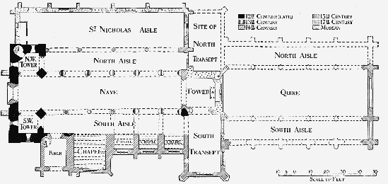
Plan of Scarborough Church
The construction of the nave arcades appears to have begun about 1200. It is probable that the existing nave walls were retained and the piers and arches constructed piecemeal beneath them. This would largely explain the fact that the piers of the north arcade are not placed centrally beneath the wall they carry, the 13th-century masons having taken no account of the serious inclination inwards of the old wall. The five piers on the north side and the two eastern piers on the south are all of the same type—cylindrical, with moulded capitals and bases —and the arches above are formed of three recessed and chamfered orders. The joining up of the north arcade and the rebuilt west front is very clumsy, owing to an error in setting out, and the western bay on this side is considerably narrower than its fellows. The building of the south arcade started at the east end, the process employed on the north side being repeated here as far as two and a half bays from the east and finishing at the crown of the arch. The work was then taken up by a man of a newer school, who with little or no interval of time began at the west end and built the three and a half bays adjoining the south-west tower. The wall here is considerably thinner than that of the eastern half, and the meeting of the two thicknesses at the point of the arch is very noticeable. The three piers in the later western portion are each of different type, the western having three attached shafts keeled on the outer edges, with an octagonal moulded capital. The second pier is a plain octagon, and the third has a central pier with six detached shafts disposed round it, banded half-way up and finished with small bell capitals beneath a large circular capital to the whole pier. The varying dates of this rebuilding are probably responsible for the unusual crookedness of the line of the arcade.
The walls above the nave arcades may in part be the original 12th-century work, but the clearstory has been entirely remodelled early in the 13th century. The windows are plain lancets with small side shafts and hood mouldings carried along the wall as a string-course. The bays are divided by stone shafts supporting the roof principals and springing from moulded corbels at the intersections of the nave arches. The fact that the columns of the two arcades are not opposite one another has interfered with this arrangement at the west end, and here the two western shafts on the south side are stopped at the sills of the clearstory windows. Externally the nave clearstory is divided by flat pilaster buttresses, possibly of 12th-century date.
The next alteration to the church in point of date was the erection of the transept, which took place about 1350. Only the southern arm is now standing. It is used as a vestry and projects 34 ft. 9 in. from the face of the tower. The diagonal buttresses are carried up and finished with gabled and crocketed pinnacles. The five-light south window is original and has flowing tracery of the honeycomb type. A smaller four-light window on the east is a 15thcentury insertion with modern tracery. In the south wall of this transept are two tomb recesses under deeply moulded arches, the western containing a stone coffin. Further east is a piscina with a shelf above. The north transept was of similar size and character, and its western wall with the angle buttress remained until the reconstruction of the outer nave aisle (1848–50). The arch opening from this transept to the inner nave aisle still remains, fitted with a modern window and entirely concealed by the organ. At the same date as the building of the transept the western arch of the crossing was reconstructed.
Towards the close of the 14th century the south aisle wall of the nave was taken down and a series of four chapels and a porch constructed outside it. The three eastern chapels correspond in width to the nave bays and are divided from one another by massive walls opposite the nave piers, with which they are connected by stone arches sprung transversely across the aisle and clumsily fitted on to the capitals. The three chapels are each lighted by a threelight window with modern tracery of good 14thcentury type, and each contains an arched tomb recess and a piscina in the south wall. The piscina in the eastern chapel has the remains of a richly carved canopy, those in the other two chapels having plain trefoiled heads. The fourth or western chapel (commonly called St. Mary's) has more than double the projection of the other three and is also considerably wider. It is otherwise similar in character and has a modern four-light window. All four chapels are roofed with pointed barrel vaults of stone resting on massive parallel chamfered ribs spaced about a foot apart. Immediately on this vault rests the roof of heavy stone slabs fitted together after the fashion common in Scotland in the 15th century. Immediately to the west of the last of these chapels stands the south porch, a building of about the same date and two stories high. The porch itself has a plain barrel vault, and the room over, approached by a modern stair, has an opening into the south nave aisle. During the latter part of the same century (the 14th) the north aisle wall was also removed and a broad outer aisle erected conterminous with the old nave. It is separated from the inner aisle by an arcade of four bays resting on octagonal piers with moulded capitals with deep hollows enriched with a series of grotesque figure carvings. The western respond bears three shields charged respectively with a fesse between three bears (?), a plain cross, a merchant's mark. The aisle itself (known as St. Nicholas aisle) was rebuilt in 1848–50 and presents no features of interest. The roof of the inner north aisle was necessarily raised on the erection of the outer arcade and now covers the clearstory windows, but the original weathering remains against the western tower.
The church is poor in monuments. There are, however, the matrices of two brasses in the outer north aisle and a small brass inscription under the north-west tower to Daniel Foord, 1682. On the nave walls are about 200 small brass plates (mainly of the 18th century) removed from tombs in the churchyard. In a detached portion of the churchyard lying to the east are the grave and headstone of Anne Brontë, the authoress, who died in 1849.
The bells, eight in number, are all modern (1852).
The plate consists of a cup, 1638 (York), inscribed, 'The gift of Mr. Willm Thompson to St. Maries Church in Scar, who died Decembr ye first 1637'; the cover appears to bear the York mark for 1672; a cup, 1672 (York); two flagons, 1720 (London), the gift of John Hungerford, 1720; a paten, 1718 (London), bought 1720; a paten, 1722 (London), the gift of Timothy Fysh, 1722; two cups and two patens, 1883.
The registers previous to 1812 are as follows: (i) baptisms 1672 to 1781; (ii) marriages 1689 to 1754; (iii) burials 1689 to 1796; (iv) marriages 1754 to 1766; (v) burials 1779 to 1796 (this is apparently the original of the later entries in vol. iii); (vi) marriages 1779 to 1812; (vii) burials 1797 to 1812.
CHRIST CHURCH, Vernon Place, is a chapel of ease to the parish church and was built in or about 1826–8, (fn. 319) the chancel being added in 1873. It consists of a nave with aisles of six bays and north, south and west galleries, an apsidal chancel and a western tower. The style employed is Gothic of the early 13th century. In the tower is a bell of 1674, brought from St. Mary.
The mission chapel of ST. PAUL, in Regent Street, is a small building erected in 1879. It contains a good Jacobean communion table brought from St. Mary.
The mission chapel of ST. JOHN, in St. Sepulchre Street, built in 1884, is an aisled building of red brick and stone, with an unfinished tower.
The church of ST. THOMAS, in East Sandgate, was built in 1840, and is a rectangular building of red brick and stone in the style of 15th-century Gothic. The living is a vicarage in the gift of the vicar of Scarborough.
The church of ST. MARTIN ON THE HILL, designed by G. F. Bodley, R.A., in 1863, is a large stone church consisting of a nave with aisles, chancel with north and south chapels, a tower on the north side of the nave and a western narthex. The style employed is 13th-century Gothic. It contains a triptych reredos of oak, with carved centrepiece and painted wings. Between the chancel and the nave is a handsome oak rood screen and loft with figures of the Virgin and St. John. The north chapel is also richly decorated with a wrought-iron screen, carved oak reredos and a painted and gilt roof. The square dark marble font is in the style of the 12th century. The living is a vicarage in the gift of trustees.
The mission chapel of ST. MICHAEL WHEATCROFT is a small red brick and stone building erected in 1879, with a bellcote containing one bell at the west end.
The church of ALL SAINTS, Falsgrave, was built in 1868 from the designs of G. F. Bodley, R.A. It is a building of red brick and stone in the 14th-century Gothic style, consisting of a chancel with south organ chamber and nave with south aisle of five bays. The oak rood screen has eleven bays with traceried heads and a loft. The living is a vicarage in the gift of the Archbishop of York and others.
The church of THE HOLY TRINITY, Westbourne Grove, was built in 1879 from the designs of Ewan Christian. It is a large building in the style of the early 13th century and consists of a nave of four bays with cylindrical columns and side aisles, a quire of one bay with a semicircular apse lighted by seven lancet windows and a tower at the west end of the north aisle. The living is a vicarage in the gift of trustees.
The church of ST. JAMES, Seamer Road, was built in 1885 and enlarged and consecrated in 1894. It is a small building of red brick and stone, consisting of chancel, nave with aisles and western narthex, and a brick bellcote surmounted by a wooden spirelet on the south side of the quire. The living is a vicarage in the gift of the archbishop.
The church of ST. SAVIOUR, Gladstone Road, was begun in 1902, and is built of red brick and stone. It consists of a chancel and nave with south aisle and chapel, with stone piers and arches. The style is 14th-century Gothic. The living is a vicarage in the gift of the archbishop.
Advowson
The church of St. Mary was of royal patronage (fn. 320) until Richard I before 1189 granted it to the Abbot and convent of Cîteaux with all its chapels and appurtenances, including the chapel in the castle, and tithes of fish, especially of the fishery called 'Doguedraue'—i.e., the Dogger Bank. No one else was to set up a chapel or altar in the parish. (fn. 321) The Prior of Bridlington unsuccessfully claimed the advowson in 1279. (fn. 322) In 1407 Henry IV granted the Cistercians leave to convey the advowson of the church and chapels and the rectory to the Prior and convent of Bridlington. (fn. 323) When, however, Henry seized all alien priories he resumed possession of this church and granted it to Bridlington Priory in February 1413–14 for as long as it should be in his hands. (fn. 324) Henry V in 1421 confirmed the same in perpetual alms on condition that the canons accounted for profit above 100s., and Henry VI in February 1441–2 released all profits. (fn. 325) The priory held the church until its dissolution. (fn. 326) In March 1538–9 the advowson was granted in tail to Charles Brandon Duke of Suffolk, (fn. 327) whose last surviving son died unmarried in 1551. (fn. 328) In 1558 it was granted to the Archbishop of York and his successors, (fn. 329) but must have been surrendered. After other leases (fn. 330) it was granted in 1592 to John Awdley and others for three lives. (fn. 331) William Lord Monteagle, Grey Lord Chandos and Anne his wife and Sir John Egerton and Frances his wife conveyed it to the king in 1608, (fn. 332) and Henry Earl of Huntingdon and Elizabeth his wife made a similar conveyance. (fn. 333) The rectory and church were granted in 1613 to the 'fishing grantees' Francis Morrice and Francis Phillipps in fee (fn. 334); by them it was probably conveyed to the Egertons, afterwards Earls of Bridgewater, to whom it soon came. The earls presented in 1630 and 1690. (fn. 335) The advowson then passed to the Thompsons of Humbleton and afterwards to the Lords Hotham, who presented (fn. 336) from 1708 to 1880, when the advowson was transferred to the Archbishops of York. (fn. 337)
In 1380 Robert Galoun had leave to endow a chantry of St. James in the parish church for his good estate and the souls of himself and others, to sing mass at the altar of St. James, to help with service and to keep an obit once a year. (fn. 338) Some of its possessions were granted to Francis Morrice and others in 1613–14. (fn. 339)
The chantry of our Lady was founded in 1390 and 1396–7 by the bailiffs and commonalty at the altar of St. Mary, to pray for their souls, help in the service, make an obit for Henry Rudston, and repair a bede-house there at his charge. (fn. 340)
In 1380 Robert de Rillington had licence to found the chantry of St. Stephen in the parish church, to pray for the souls of persons named and to help with services. (fn. 341)
In 1390 Agnes Burn had leave to grant tenements to a chaplain to celebrate service at the altar of St. Nicholas in the parish church for her good estate and the souls of certain folk. (fn. 342) The aisle of St. Nicholas is mentioned in 1503, (fn. 343) that of Corpus Christi in 1500. (fn. 344) Peter Shilbottle in 1504–5 left 20s. for gilding the image of St. Peter in the parish church. (fn. 345) Chapels of St. Clement, Corpus Christi, St. Cross, St. Nicholas and St. Christopher in the parish church are referred to in Torre's MSS. (fn. 346)
Edward I inquired into the right of the Abbot of Cîteaux to present to the chapel of St. Mary in the castle, (fn. 347) and Edward II took it into his hands when he had the town. (fn. 348) Leland mentions it. (fn. 349)
Sir Robert Percehay, kt. (of Ryton), had licence to found the chantry of St. Mary Magdalene in the Charnel in 1394. (fn. 350) In 1396 John Duke of Lancaster granted to the chapel of the Charnel 6 marks yearly, (fn. 351) which, when his son Henry became king, was taken from the farm of the town. (fn. 352) Henry IV presented in 1401, (fn. 353) and in 1463 it was called the king's chantry, and said to have been founded by Richard II. (fn. 354) In 1535, however, the advowson of the 'Perceys chaunterie' was settled with the Percehays' manor of Ryton, (fn. 355) and at about this time its goods were taken away by William Percehay. (fn. 356) In Charnell Garth, a field outside Scarborough, many coffins and human remains have been found. (fn. 357)
The chapel of St. Sepulchre, consecrated in 1306, (fn. 358) was appurtenant to St. Mary's in 1428. (fn. 359) It was demolished in 1564. (fn. 360) On the east side of the upper end of St. Sepulchre Street Gothic arches are to be seen walled up in the dwellings. (fn. 361) St. Clement's Chapel, Falsgrave, (fn. 362) was appurtenant to St. Mary's in 1428, (fn. 363) and a bequest was made to the fabric in 1496–7. (fn. 364) It was granted by Elizabeth in 1566 as 'our little chapel' to Thomas Blackway and Francis Barker in fee, (fn. 365) and is no more heard of.
In 1864 skeletons were found in St. Helen's Square, and a field called St. Helen's Close, behind Westfield Terrace, (fn. 366) belonged to the Dean and Chapter of York. If there was ever a chapel of St. Helen it had disappeared by 1428, (fn. 367) and the same is the case with the supposititious chapel of St. John. (fn. 368)
In 1426 mention is made of the gilds of St. Clement, the Holy Trinity, St. Scytha, St. James, St. George, St. Nicholas, Corpus Christi, the Assumption of the Blessed Virgin Mary and All Saints. The gild of St. John the Baptist was in existence in the previous year. (fn. 369)
Charities
The municipal charities, whereof trustees were appointed, and a scheme established for their administration by an order of the Charity Commissioners dated 2 August 1904, comprise the following charities, viz.: Burgh's Hospital and Farrer's Hospital, the sites of which were sold and the proceeds invested in £50 19s. 2d. consols, and £78 13s. consols respectively; North's Hospital, being four almshouses at Tollergate; Robinson's Hospital, four almshouses in Long Westgate; St. Thomas's Hospital, twelve almshouses in Hoxton Road, supposed to have been founded by Hugh de Bulmer, (fn. 370) temp. Henry III; a hospital founded by the will of Thomas Sedman, 1714, consisting of fifteen almshouses in Cross Street, endowed with £400 Scarborough Corporation 3 per cent. stock, and an annuity of £1 paid out of the May Day charity mentioned below; and finally, the Spinsters' Hospital, founded by Mrs. E. Clark by deed 1841, being seven almshouses, formerly in St. Thomas Street, but in 1911 rebuilt in St. Thomas Walk and endowed with £400 like Corporation stock, and £72 14s. 5d. India 3 per cent. stock. The several securities are held by the official trustees, who also hold a further sum of £100 Corporation stock, arising from the unexpended salary of the mayor, in trust for the various hospitals. In March 1907 there was a balance in hand of £126 15s. Kendall's Hospital consists of eight almshouses in St. Mary's Street, conveyed by Colonel John Kendall by deed of 1 February 1896 and endowed with £2,074 South Eastern Railway 4 per cent. preference stock with the official trustees. These almshouses are under a scheme of 1896 kept in repair by the income of the above-mentioned sums of consols belonging to Burgh and Farrer Hospitals.
The municipal charities' trustees also administer the charities of Sir John Lawson, 1665, Mrs. Conyers, and Alice Chambers, endowed with £160 Corporation stock, and the charity of William Benjamin Fowler, founded by will, proved at York 12 August 1872, for the benefit of poor women in the parish of Scarborough. The trust fund consists of £3,587 8s. 10d. consols with the official trustees, producing a yearly income of £89 13s. 8d., which in 1906 was distributed monthly in alms to widows and spinsters in sums of 3s. to each recipient and about £30 in coal is annually distributed to the deserving poor.
Thomas Sedman above mentioned also devised a piece of land, known as the Burr Causeway Close, adjoining the hospital founded by him, the rents thereof, subject to the payment of 20s. a year for repairs, to be distributed on 1 May at the door of St. Mary's Church among the poor frequenting the same. William Magginson in 1697 also devised a close adjoining the above, the rents thereof to be distributed among the poor annually on May Day. The lands, containing together 4 a. 2 r. 32 p., were in 1896 sold, and the proceeds invested in £925 18s. 6d. consols with the official trustees. The annual dividends, amounting to £23 2s. 8d., are distributed under the title of the May Day Charity by the churchwardens to the sick and poor of St. Mary's and St. Thomas's parishes, after deduction of 20s. for repairs of Sedman's Hospital above mentioned.
Endowments for Merchant Seamen.—The Merchant Seamen's Hospital, situated in Castle Road, and the Trinity House in St. Sepulchre Street, consist of thirty-six and thirty-one dwellings respectively for married and disabled seamen or their widows. In 1906 the trust funds consisted of £837 consols and £500 Lancashire and Yorkshire Railway stock, representing the legacies of William Solit, 1812,—Williamson, 1820, and the gift of Rachel R. Cross, 1887; also £375 consols, arising apparently from investment of surplus income. In addition to the dividends thereon, £76 2s. 6d. was then received in respect of rents, &c. The inmates of the Merchant Seamen's Hospital received 13s. each and of the Trinity Hospital 7s. 6d. each, £51 9s. 4d. was paid for repairs, salaries and sundries, and £250 consols was purchased out of surplus income, leaving a balance in the hands of the trustees of £166 17s. 2d. (fn. 371)
Wilson's Mariners' Asylum in Castle Road, founded by deeds of 1837 and 1852, consists of fourteen almshouses and gardens, and is endowed with £7,575 0s. 5d. consols arising under the founder's will, proved at York 18 November 1837. The official trustees hold the stock, as well as a sum of £248 10s. 3d. consols as a repair fund, producing together £195 11s. 6d. a year. In 1906 £153 was paid to the inmates.
Other charitable institutions.—Trott's Hospital: In 1697 Elisha Trott by will devised two tenements in Tanner Street for the use of two poor widows and 1 acre lying in Burton Dale for their maintenance. The land has been sold. The official trustees hold £589 9s. 5d. consols in trust for this charity, producing £14 14s. 6d. a year. An almshouse situated in Quay Street was founded by Cornelius Stubbs, who devised the same to the vicar and churchwardens.
Taylor's Free Dwellings erected in 1817 on land in Cook's Row, purchased with a legacy bequeathed by will of Joseph Taylor, dated 4 May 1810, were endowed with £800, which included a gift in 1839 by — Mennell. The trust funds are secured upon mortgage.
The Wheelhouse Free Almshouses in Dean Road consist of forty dwellings for the poor of Scarborough; they were founded by George Wheelhouse by deed dated 6 January 1865 and by Mrs. Elizabeth Buckle. New trustees were appointed by order of the Charity Commissioners 12 February 1907.
The Royal Northern Sea Bathing Infirmary in Foreshore Road, for affording means for poor persons to reside at the seaside and have sea-bathing, was endowed by the will of Richard Welch Hollon, proved 1890, with £514 2s. 9d. consols with the official trustees. A Working Men's Temperance Hall was founded by deed 1867.
The Yorkshire Convalescent Home for ladies of limited income, founded by deed of 1875, was originally carried on at No. 20 Albion Road. These premises were sold in 1882, and premises known as St. Martin's Lodge were acquired for the purposes of the institution.
The Home for Orphan and Friendless Little Girls, situated in Park Street, Falsgrave, founded in 1882, was endowed by will of Miss Dorothy Mary Chambers, proved 20 September 1897, whereby the testator bequeathed her residuary estate upon trust to be invested and the income applied towards the general purposes of the institution. The trust fund consists of £969 North Eastern Railway stock. The girls are trained chiefly for domestic service.
Distributive charities.—In 1717 Richard Allatson gave to the poor 4 oxgangs of land at Weaverthorpeon-the-Wolds in the East Riding, in lieu of which on the inclosure in that parish 38 a. 0 r. 10 p. were allotted. The land is let at £40 a year, the net income being distributed amongst the poor by tickets of 1s. each for coals or provisions.
In 1810 Joseph Taylor by will, dated 4 May of that year, devised lands for providing the poor with coals. The land was sold in 1868 and 1870 and the proceeds invested in £1,655 6s. 4d. consols with the official trustees. The dividends, amounting to £41 7s. 8d., are duly distributed.
In 1825 Mrs. Eleanor Cockerill by her will, dated 16 August, bequeathed her residuary estate to trustees upon trust to invest the same and pay the income to the vicar and churchwardens for distribution every Christmas amongst poor widows, inhabitants of Scarborough. The amount of the residue was invested in £1,684 4s. 2d. Reduced Stock, now New Consols, producing £42 2s. a year, which in 1906 was distributed to 359 poor widows in sums varying from 1s. to 4s. 6d. according to age. The stock is standing in the bank books in the names of the persons appointed for the purpose by the Charity Commissioners in 1867.
In 1864 Mary Ann Fryer, by will dated 28 May, bequeathed £387 14s. consols (with the official trustees), the dividends, amounting to £9 13s. 8d., to be applied by the vicar and churchwardens of St. Mary's Church in the distribution of coals and blankets among deserving poor of Scarborough parish. The same donor also bequeathed £385 1s. 9d. consols (with the official trustees), the dividends, amounting to £9 12s. 4d., to be applied by the trustees in the distribution of coals and materials for clothing amongst necessitous widows and families of deceased fishermen at Scarborough.
Ecclesiastical charities.—St. Mary's Church lands, appropriated by the corporation for the repairs of the church, have from time to time been sold and the proceeds invested in Government stock. The official trustees in 1907 held £14,561 1s. 3d. India 3 per cent. stock, producing an annual income of £436 16s. 8d. In 1899 a sum of £900 was set aside with the official trustees to be accumulated at compound interest until a sum was produced to replace that of £647 7s. 8d. stock, which was sold out to defray the cost of the enlargement of the quire and providing new stalls. This fund amounted in January 1908 to £1,151 7s. 8d. consols. A sum of £2 10s. a year is also received by the trustees as an easement. By an order of the Charity Commissioners, dated 20 February 1872, the vicar and churchwardens jointly with others were appointed trustees and a scheme established for the administration of the trust.
Nonconformist charities. — The Congregational church, formerly the Old Meeting House, is endowed with a sum of £1,190, on mortgage at 4 per cent.; this sum represents gifts by — Collier, — Burns, and — Kirk, and includes £100 left by Georgiana May Kidd by will proved 1890. The income is applied towards the maintenance of the officiating minister and for church purposes.
In 1873 Mrs. Ann Morley, by will proved 25 February 1873, left £152 17s. 9d. consols (held by the official trustees), one moiety of the interest to be given to the sick and indigent poor of the Jubilee Chapel in connexion with the Primitive Methodists and the other moiety for the Sunday school of the same chapel and Band of Hope.
Wesleyan educational charity.—See below.
Educational charities.—For the church or grammar school see article on schools. (fn. 372) The official trustees hold under the title of the United Scholarships Foundation the sums of £484 9s. 2d. consols and £4,609 9s. 3d. local loans 3 per cent. stock, which were determined by an order, dated 6 November 1903, made under the Board of Education Act, 1899, to be applicable for educational purposes. The dividends, amounting to £150 7s. 8d. a year, are applied subject to the provisions of the scheme under the Endowed Schools Act, 17 May 1888.
The Amicable Society Schools, founded 1798, were endowed with a close known as Cockhill Close, and a small close adjoining, containing together 7 acres or thereabouts. The land was sold in 1877, and the proceeds invested in consols, which in 1888 were sold out and reinvested in £1,816 7s. 1d. Bank stock, augmented in 1895 by a sum of £405 6s. 3d. Bank stock, purchased with £1,350 belonging to the trust. The Bank stock, amounting to £2,221 13s. 4d., is held by the official trustees, and produces an income of £210 5s. 6d. a year, which with two rent-charges of 10s. each charged on two houses in St. Nicholas Cliff is applied in educating and clothing the scholars.
The Wesleyan educational charity consists of £647 10s. 4d. consols, with the official trustees, arising from the sale of the trust property of the Wesleyan school, founded by deed 1856. The annual income of £16 3s. 8d. is applied in pursuance of a scheme of the Charity Commissioners of 9 October 1891.
The Taylor educational foundation, arising under the will of Joseph Taylor, 1810, was under an order, dated 29 November 1904, made under the Board of Education Act, 1899, determined to consist of £100 5 per cent. preference stock of the Scarborough Gas Company and a sum of £35 14s. 10d. cash.
The Scarborough National schools were erected in 1837, and were endowed in that year by the Rt. Hon. Charles Duncombe, Lord Feversham, with £300, now represented by £325 13s. consols held by the official trustees upon the trust of a deed poll dated 2 February 1857.
In 1893 George Peckitt Dale by will bequeathed a legacy represented by £267 17s. 2d. consols, with the official trustees, the income to be applied in prizes for essays by school children in connexion with the Society for the Prevention of Cruelty to Animals.
John Horne, M.D., by indenture of 19 June 1909, conveyed to trustees land in Londesborough Road with eight homes erected thereon for the benefit of aged deserving persons born in the borough of Scarborough or resident there for twenty years. The founder also gave a sum of £200 in his lifetime and a legacy of £300 by a codicil to his will, proved at York, 3 May 1910, which sums are invested with the Scarborough Corporation.