Survey of London: Volume 22, Bankside (The Parishes of St. Saviour and Christchurch Southwark). Originally published by London County Council, London, 1950.
This free content was digitised by double rekeying. All rights reserved.
'Bankside', in Survey of London: Volume 22, Bankside (The Parishes of St. Saviour and Christchurch Southwark), (London, 1950) pp. 57-65. British History Online https://www.british-history.ac.uk/survey-london/vol22/pp57-65 [accessed 26 April 2024]
In this section
CHAPTER 7: BANKSIDE
Next to Borough High Street, the road along the river wall of which Bankside forms a part is perhaps the oldest in the area. There has been little change in its position relative to the river through the centuries, in contrast to the Strand on the north bank which once bordered the river but is now widely separated from it by reclaimed land.
Bankside was notorious before the Reformation as the place where the licensed brothels or "stews" of London were kept. Stow (fn. 26) tells us that these houses, which were usually approached by boat across the river, "had signes on their frontes, towardes the Thames, not hanged out, but painted on the walles, as a Beares heade, the Crosse Keyes, the Gunne, the Castle, the Crane, the Cardinals Hatte, the Bell, the Swanne, etc." The position of some of these is marked on the map on Plate 59. The derivation of the term "stew" is interesting. It probably comes from the word formerly current both in this country and in Scandinavia for a stove or heated room. On the other hand the same word was used in the mediaeval period for a fish pond, and there were a number of fish ponds in the "Pike Gardens" along Bankside so that the term "stews bank" often applied to this region may have had a double entendre. An unsuccessful attempt was made to abolish the stews in 1506 and they were finally put down in 1546 when Bankside was "proclaymed by sounde of Trumpet, no more to be priuiledged, and vsed as a common Bordell, but the inhabitantes of the same to keepe good and honest rule." (fn. n1) (fn. 26)
There were three pike gardens along Bankside in the 16th century. These were the pike garden of Winchester House, the King's (or Queen's) Pike Garden, which lay a little to the west of the site of Emerson Street, and the Great Pike Garden, the approximate site of which is marked by the little court originally called Pike Gardens and now White Hind Alley.
The King's Pike Garden had formed part of the estate of the priory of the nuns of Stratford at Bow. When it was surveyed during the Commonwealth period it contained four fishponds and two or three small houses and gardens. It remained the property of the Crown until 1831 when it was divided and sold to Thomas Evans, cooper, of Great Guildford Street, Southwark, and John Lewis of Euston Square. Pond Yard, which ran through the centre of the property (see the map on Plate 59), was closed in 1904.
The Great Pike Garden dates back at least to the middle of the 14th century, for in 1361/2 it was sold under the description of a garden and ponds at "le stewes" to John Trig, citizen and fishmonger, of London. In the 15th century it was in the ownership of Christopher Banaster and his son, John, and became known as Banaster's Garden. In 1499 it contained three acres, four cottages, a gatehouse, and seventeen ponds, etc. Early in Elizabeth's reign it was purchased by John Gybon or Gibbons and it remained in the possession of his family until it was sold to Philip Henslowe in 1615.
An account of the bear gardens and theatres on Bankside in the Tudor and Stuart periods is given in the next chapter which also contains much information about the topographical development of the district.
Although the Bishops of Winchester had alienated most of the land along Bankside before the period when the records begin, they retained possession of a piece of ground at the river end of Bear Gardens frequently referred to in the account of the Bear Gardens (on pp. 66–71) and of a triangle of ground at the western end of the Clink Liberty abutting north on the river and adjoining on Holland Street (formerly Gravel Lane, i.e. the boundary of Paris Garden Manor) to the west and on Fletcher Lane (formerly Love Lane) on the east. Both these plots are marked on the plan on Plate 59. In the 15th century the Knights Hospitallers tried to incorporate the land next to Gravel Lane in the Manor of Paris Garden but the bishop vindicated his right to it in a suit at common law against Robert Bottell, the prior temp. Henry VI. (fn. 109) Subsequently most of the bishop's land at the west end of Bankside was leased to the "Parson and Churchwardens" of St. Martin Orgar, London, a lease which was renewed in 1541. (fn. 110)
By 1661, when Winchester House and Park were being leased out, much of the St. Martin Orgar land was built on, though part of it was still described as "a great Orchard and Garden." (fn. 110) At that date Mouldstrand Dock and twenty-two messuages near it were leased to James Shaw, citizen and merchant tailor, and the rest of it, with the exception of the Falcon, was granted to Thomas Walker, the man who had bought Winchester House and built on it. In 1674 we find William Angell, lord of the manor of Paris Garden, making an unsuccessful claim to the Falcon Inn which adjoined his property. (fn. 111) Subsequently the bishop leased the Falcon to John Hayward, citizen and haberdasher of London, and his son Henry, who is described as a "carpenter." (fn. 112) They rebuilt the Falcon Inn circa 1690 and also the house adjoining, which, together with Falcon Wharf, was stated in 1708 to be in the tenure of the Company of the Mine Adventurers of England. (fn. 113) In the later part of the century this property was occupied by Gilbert Handasyde and Thomas Prickett, ironfounders. (fn. 114) The premises of the London Hydraulic Power Company now cover the site. No confirmation has been found in the records for the statement on the wall plaque there that Sir Christopher Wren frequented the house and watched from thence the rebuilding of St. Paul's Cathedral. There is a water-colour drawing in the Guildhall Collection which is stated to represent Wren's house near the Falcon Inn on Bankside. It probably represents the house next the Falcon built by John Hayward.
Clarks Alley, to the east of Falcon Wharf, was closed at the end of
the 18th century. A tablet on the wall bears the inscription—
This ancient Way called Clarks Alley
leading from Willow Street to the
River Thames, being a free Passage
and landing Place was closed by
order of the Commissioners of the Clink Pavements.
The wharf and dock called Mouldstrand appear to have been in use in the Middle Ages. There is a reference to Philip Henslowe leasing property there to John Serieant, a waterman, in 1608 (fn. 79) and later in the 17th century it was in lease to James Shaw and his daughter Alice Shaw Overman. (fn. 115) In 1784 when Mouldstrand was in the tenure of John Cater, the dock had been "for some time past filled up." (fn. 116) Queen's Wharf now occupies the site.
The eastern part of the bishop's land south of Bankside (or Willow Street) was occupied by a large glasshouse belonging to Stephen Hall, glassmaker, in the 18th century. (fn. 116) The ground was subsequently used for over a century by the Phoenix Gas Company (incorporated in 1824) and its successor the South Metropolitan Gas Company. This property, together with Queen's Wharf on the riverside, was bought by the City Electric Light Company in 1938. The new Bankside Power Station is to be erected on the site.
The Peacock Brewery is shown south of the glassworks on Rocque's map of 1761. Most of the remainder of the bishop's triangle of land south of Bankside was in lease to Sir John Cullum and his sons, Sir John and Sir Thomas Gery Cullum throughout the 18th century. (fn. 117)
The greater part of the land abutting on Bankside is now given over to wharves, warehouses and factories, but some of the old narrow alleys, Rose Alley, Bear Gardens, Cardinal's Cap Alley, etc., still exist. The view on Plate 54a gives some idea of the appearance of Bankside at the beginning of last century. A description and brief account of the few pre-1800 buildings which have survived is given below.
The Anchor, No. 1 Bankside
The Anchor has a late 18th-century front in brown brick. It is of two storeys and an attic and has a tiled roof with a dormer window behind the parapet. The main front has a three-light wood shop window with pilasters at the sides and hinged shutters. Above, on the first floor, is a shallow overhanging bay with double-hung sashes and glazing bars. On the flank (in Park Street) the windows have segmental heads, plain reveals and doublehung sashes with glazing bars; those on the ground floor have wood shutters. There is also a shop window of similar type to that on the main front.
The bar has plain dado panelling and a mantelpiece of late 18th century date. The back parlour has plain matchboarding of similar date with some later alterations.
In the first floor front room is an elliptical arched recess with panelled pilasters ornamented with sprays of corn. The panelling is mid-18th century but has been altered and added to in later years. The mantelpiece is plain and encloses an early 19th-century grate.
The house was damaged by enemy action during the last war but has since been repaired. It is often stated that the Anchor Tavern dates from the 17th century though both historical and architectural evidence point to a date during the last quarter of the 18th century. The ground on which the tavern stands has a long and tangled history and as it throws many interesting sidelights on the development of the neighbourhood it is given in some detail.
On the ground at the junction of Bankside and Park Street (formerly known as Bank End) there stood in the 15th and 16th centuries an inn called "the Castell upon the Hope" with a wharf, houses and four cottages. In 1479 they were in the possession of John Eierby, citizen and fishmonger of London, who died in 1500 leaving them to his wife, Elizabeth, with the proviso that after her death they were to be sold and the proceeds devoted to "deedes of almes and werkes of charite." (fn. 118) The Castle was one of the Stewhouses of Bankside and in 1506 John Sandes, the occupier, was presented by the constables at the Court Leet of the Bishop of Winchester for keeping his house open on feast days and for allowing women to board there contrary to the regulations. (fn. 119)
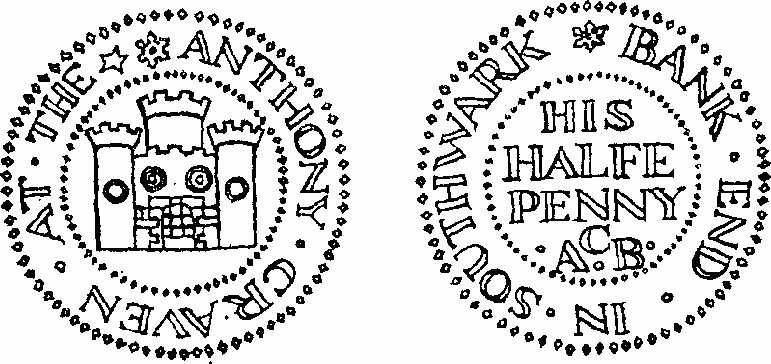
Token of Anthony Craven, the Castle, Bank End
In 1559 Alexander Amcottes sold (fn. 120) to Vincent Amcottes, citizen and fishmonger of London, his messuage called "the Castell on the hoope" with a wharf and houses and four cottages adjoining on the east and "Cellers, Sollers, Gardeyns, Pondes, hedges and dyches" abutting on the land formerly of William Owghtred, knight, "late apperteynyng to the Churche of Saynt margarettes" on the south and "extendeth in length from the kynges highewaye of olde tyme called the millwaye towardes the Easte unto the landes . . . sometyme of Sir Myles of Stapylton and Thomas Paterling and late belongyng to the churche of Saynte Margarettes . . . towardes the Weste."
Vincent Amcottes divided the property. The southern portion he sold in 1580 to Richard Spier. (fn. 121) In the 17th century it was the subject of many lawsuits but in 1707 (fn. 122) it was in the possession of Spier's great grandson who stated that two messuages and a dyehouse had been built thereon. It was bought by Ralph Thrale in 1739 and subsequently a watchhouse was built on part of it and the rest was used to widen Park Street. (fn. 123)
The northern portion was sold by Vincent Amcottes in 1562 to John Cheyne (fn. 124) whose son and heir, Henry, on 30th January, 1582/3, transferred it to John Drew under the description of "all those two messuages . . . called the gonne and the castle with twoe gardeins thereunto adjoyninge . . . and . . . all those twoe tenementes on theast side next adjoynynge to . . . the Castell and all the gardein plattes and voyd groundes on the backsides of the same . . . and . . . all the wharfe which is betwene the foresaid messuages . . . and the River . . . and . . . the stayers and landinge place . . . sometyme in the tenure . . . of John Smythe carpenter . . . and all those three messuages . . . with gardens . . . sometyme in the severall tenures of William Clement Taillor, John Roo Chaundeler and Peter Hardinge, Blacksmythe." (fn. 125) The last three houses had then been divided into six. John Drew died in 1595. By his will (fn. 126) he left 40s. to his tenants on Bankside to "make merry withall." His son John, who inherited the property, then known as Drew's Rents, got himself heavily in debt (perhaps by too much merry making) and had to sell (fn. 123) his inheritance to James James, apothecary, to whom his son, another John, was apprenticed. There were then fourteen tenements in the rents.
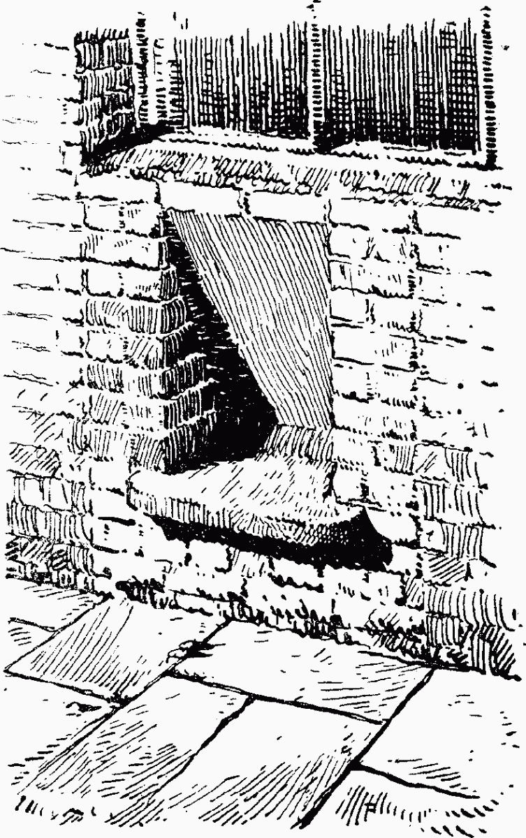
The Ferryman's Seat
James James died in 1689 (fn. 123) and the property was sold by his legatee, James Coysh, to Walter Gibbons (fn. 123) who in 1725 sold it to Edmund Halsey. In 1764 Henry Thrale, who had obtained a lease of the premises from Halsey's executors, bought the freehold. (fn. 123) Among the records of Barclay Perkins and Co., Ltd., is a note made just prior to this purchase stating that Mr. Edward Dodson had lived at the alehouse at the corner called the sign of the Castle for the previous seven or eight years. The premises were in a tumbledown state and in 1770 the ground was let on building lease to William Allen who undertook to spend £1,000 within the next five years in building "good and substantial" messuages or warehouses on the site. By 1787 when Robert Barclay and John Perkins bought the Anchor Brewery, Joseph Bickerton was the tenant of the dwelling house, warehouses, stables and wharf erected at Bank End by Allen.
The Anchor Tavern was therefore erected in 1770–75 by William Allen, though the first mention of it by its present name which has been found is in a list of recognisances for 1822.
The Ferryman's Seat
Inserted in a modern building at the corner of Bear Gardens and Bankside is an old stone seat said to have been taken from an earlier building and to have been made for the convenience of watermen.
Cardinal's Wharf, No. 49 and Nos. 50–52 Bankside
No. 49 Bankside is a three-storey early 18th-century building with a stucco front of later date and double steep pitched tiled roof with central valley. The front windows have moulded architraves and double-hung sashes with glazing bars, those on the ground and first floor having in addition a frieze flanked by two consoles supporting a cornice. The doorway is similar in design to these windows and has a simple fanlight (Plate 55b).
The staircase is of pine with solid moulded string, square balusters and square newels. The ground floor front room is panelled and has a deep moulded wood cornice. On the first floor, the front room has a plaster cornice and an early 19th-century mantelpiece in stone. The front room on the second floor is panelled and the mantelpiece has a stone bolection moulding.
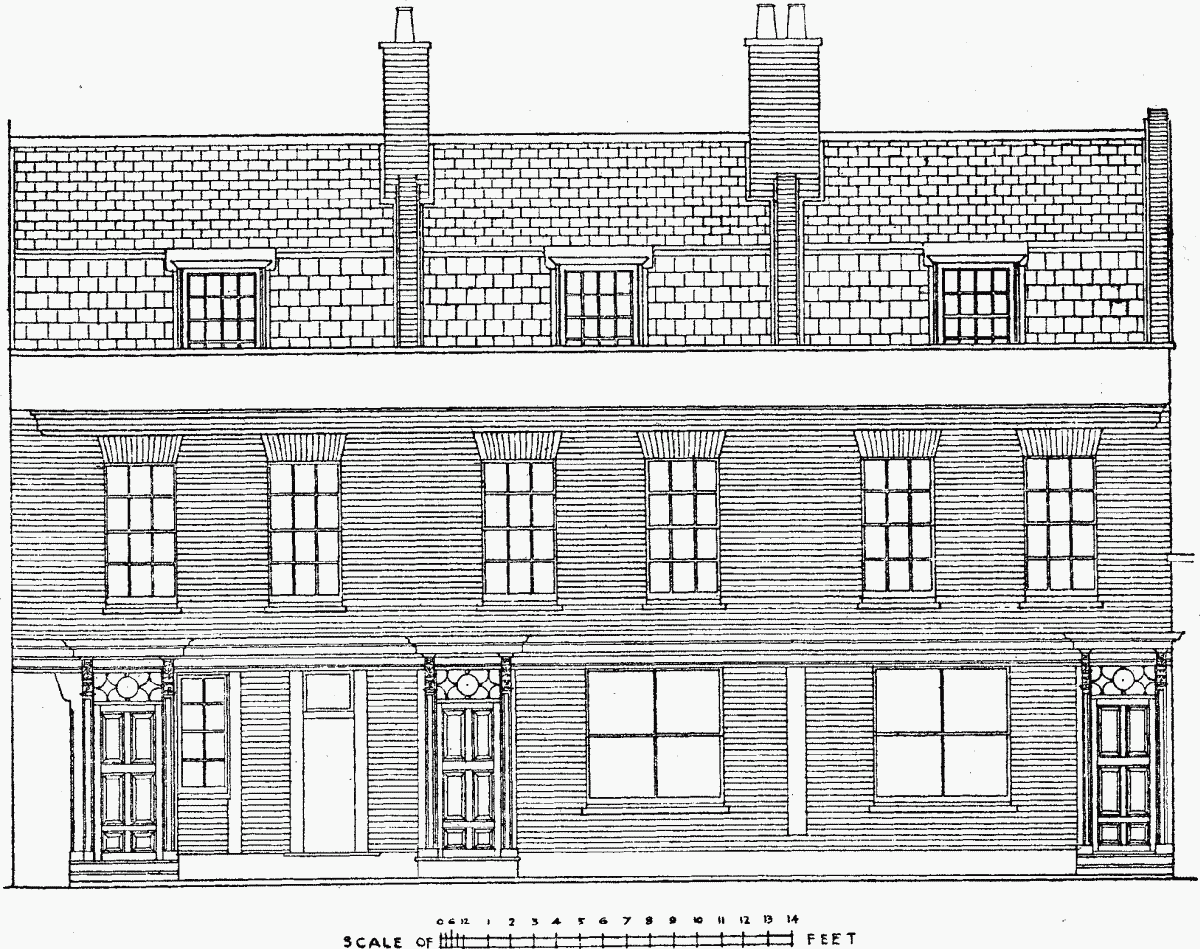
Nos. 50, 51 and 52 Bankside
Nos. 50, 51 and 52 Bankside, on the west side of Cardinal's Cap Alley, are of brick with red brick dressings. They are two-storey houses with attics, the dormers being in a slate mansard roof behind a cemented parapet below which is a moulded brick string course. Until recently there was a lead rain-water head on the front bearing a crown and inscribed "B.H.S. 1712." A wood entablature at first floor level extends across the front of all three houses and over the alley, breaking forward over the three doorways to form canopies supported on carved brackets with lions' heads and acanthus leafage (Plate 54b). The entrance doorways have wood casings with panelled pilasters and fanlights of a geometrical design in metal. The front, above the ground floor, appears to have been rebuilt. Internally, some of the rooms retain their panelling but no features of special interest remain. The houses are derelict and in poor condition.
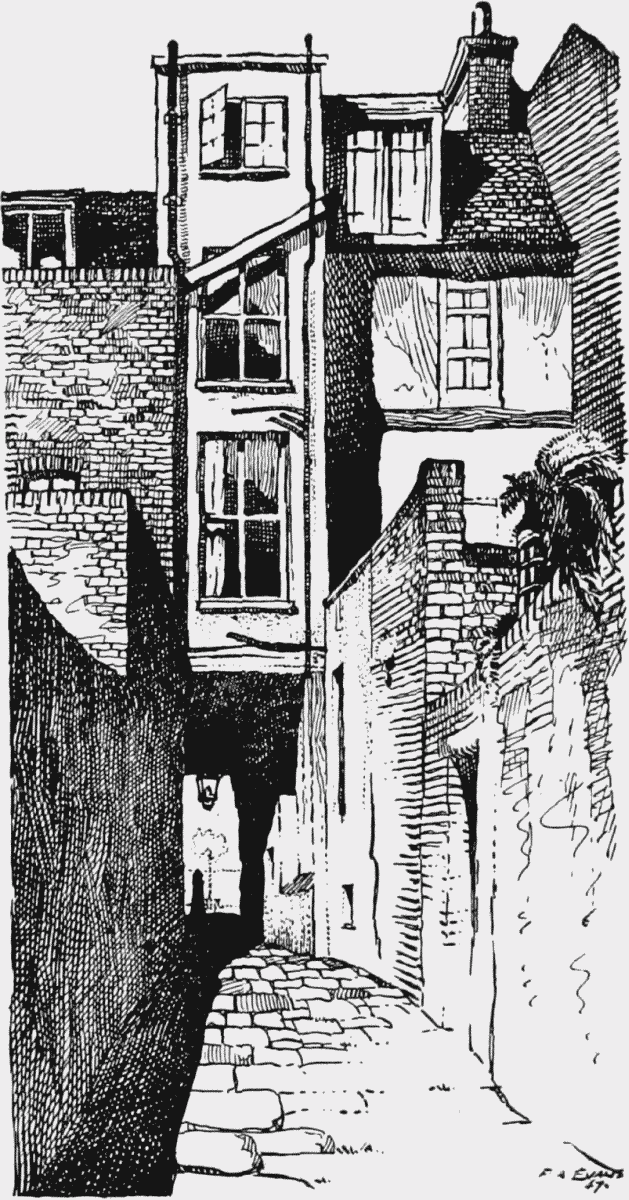
Cardinal's Cap Alley
The name Cardinal's Hat (or Cap), for a house on the site of the present No. 49, Bankside, and for the narrow alley which runs down beside it, dates from at least the time of Elizabeth and perhaps earlier. The suggestion that it was named in compliment to Cardinal Beaufort is attractive but untenable, for Beaufort died in 1447, and the original Cardinal's Hat was not built till many years later. The site was described in 1470 as "a void piece of ground." (fn. n2) It is possible that it was named after Cardinal Wolsey who was Bishop of Winchester from 1529–30, though no buildings are mentioned in a sale of the site from John Merston, fishmonger, to Thomas Tailloure, fishmonger, in 1533. (fn. 128) Stow (fn. 26) lists the Cardinal's Hat as one of the Stewhouses but he may possibly have been mistaken, including it only because it was one of the more prominent inns on Bankside in his day. It is shown in the Token Book for 1593 as in the occupation of John Raven and as one of a group of houses which in the book for 1588 is described as "Mr. Broker's Rentes." Hugh Browker, later the owner of the Manor of Paris Garden, was in possession of ground there in 1579 (fn. n3) and it seems likely that he was responsible for the formation of Cardinal's Cap Alley if not for the building of the original house.
Thomas Mansfield was the tenant of the inn when Edward Alleyn dined there with the "vestrye men" of St. Saviour's parish in December, 1617. (fn. 130)
A few years later John Taylor, the water poet, makes reference to having supper with "the Players" at the Cardinal's Hat on Bankside. (fn. 131) Melchisedeck Fritter, brewer, who tenanted the house from 1627 (fn. 108) to 1674, (fn. 132) issued a halfpenny token. (fn. 133) He was assessed for seven hearths in the hearth tax rolls. (fn. 134)
No. 50 Bankside. Details of doorway. Measured drawing by R. G. Absolon
The freehold was sold by Thomas Browker to Thomas Hudson in 1667. (fn. 135) The latter died in 1688 leaving his "messuages on Bankside" to his sister, Mary Greene, with reversion to his great nieces, Mary and Sarah Bruce. (fn. 136) It was at about this date that the oldest part of the present house was built. During the 18th century it was bought by the Sells family who both owned and occupied it until 1830. (fn. 32) In 1841 Edward Sells of Grove Lane, Camberwell, bequeathed his freehold messuage and yard and stables, being No. 49 Bankside, then in the tenure of George Holditch, merchant, to his son Vincent Sells. (fn. 137) The house is now the property of Major Malcolm Munthe, the son of Dr. Axel Munthe, author of The Story of San Michele and other works. It had previously been occupied by Anna Lee, the actress.
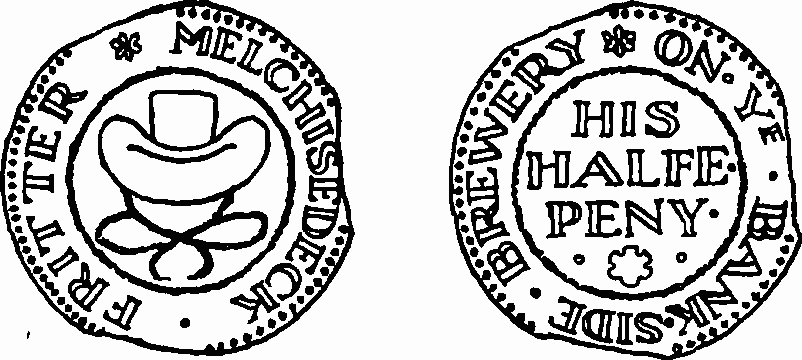
Token of Melchisedeck Fritter, the Cardinal's Hat, Bankside
Nos. 50, 51 and 52, Bankside were also in the ownership of Edward Sells at the time of his death in 1841. They were purchased in 1937 by the City Electric Light Company and are now the property of the Electricity Board.
No. 74 (Honduras Wharf)
This is a pleasant early 18thcentury brick house built at right angles to the street. It has three storeys, the third added lately in place of an attic.
The entrance door on the west front has a wood casing, over which is a cornice supported by two large and one smaller carved scrolled brackets with carved ornament between them.
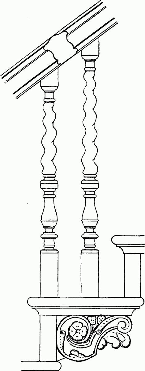
The staircase is of oak and has cut strings with carved brackets, spiral-turned balusters (two to a step) and newels in the form of fluted columns. The walls of the hall and staircase have simple moulded panelling. Some of the rooms on the ground and first floors retain their original panelling and moulded cornices, and some chimney-pieces retain the bolection moulded panels above the fireplaces.
No. 74 Bankside
The north end of the premises above first-floor level has been rebuilt following damage by enemy action.
The house known as Honduras Wharf stands on part of the ground leased to John Cullum, draper, by the Bishop of Winchester in 1670. It remained in the hands of the Cullum family until 1778 when Elizabeth Chitty, of Witham, in Essex, obtained a lease of it. Ten years later the lease was renewed to John Bond. In 1871, Daniel Sutton, who had had a lease of the property from the bishop in 1850, bought the freehold. (fn. 97) His successors sold it to the present owners, Messrs. Wakeley Bros. (fn. 138)
The name Honduras Wharf dates back to the late 18th century, when the house and wharf were in the tenure of Thomas Woodward, who was trading in mahogany with Honduras.
The occupants of the premises so far as they have been ascertained were: 1773–85, George Wyatt, carpenter and builder; 1786–96, Thomas Woodward & Co., mahogany merchants; 1796–1802/4, Wm. Clarke & Co., tire and nail warehouse; 1802/4–1816, John Pritchard, tire and nail manufactory; 1817–20, Joseph Bury, mahogany, timber and deal merchant; 1817–28, Jas. Dowson & Co., mahogany merchants; 1833–59, W. Ward, "manufactor of Roman cement, Plaster of Paris, and Importer and Shipper of all kinds of Fire Bricks, Tiles, etc., and coal merchant"; 1856–59, Edward White & Co., timber merchants; 1857–79, John Newton & Co., firebrick merchants; 1876 to date, Wakeley Bros., brick and tile merchants. (fn. 31)
No. 74 Bankside
No. 79 (Falcon Drawing Dock)
The Falcon Drawing Dock and the premises on the east side, No. 79 Bankside, are on the site of part of the Falcon Inn. They were leased to Messrs. Newton & Sons, firebrick merchants, the present owners, in 1833–4 by Messrs. Handasyde & Prickett, who had a lease from the Bishop of Winchester. No. 79, the office, was rebuilt in 1840 though it retains two patches of early 18th-century walling. The door and windows facing the dock on what now forms the main front, and those at the north end, are treated with classical mouldings. They date from the rebuilding.