Survey of London: Volume 25, St George's Fields (The Parishes of St. George the Martyr Southwark and St. Mary Newington). Originally published by London County Council, London, 1955.
This free content was digitised by double rekeying. All rights reserved.
'The manor of Walworth and parish of St. Mary, Newington', in Survey of London: Volume 25, St George's Fields (The Parishes of St. George the Martyr Southwark and St. Mary Newington), ed. Ida Darlington (London, 1955), British History Online https://www.british-history.ac.uk/survey-london/vol25/pp81-90 [accessed 30 April 2025].
'The manor of Walworth and parish of St. Mary, Newington', in Survey of London: Volume 25, St George's Fields (The Parishes of St. George the Martyr Southwark and St. Mary Newington). Edited by Ida Darlington (London, 1955), British History Online, accessed April 30, 2025, https://www.british-history.ac.uk/survey-london/vol25/pp81-90.
"The manor of Walworth and parish of St. Mary, Newington". Survey of London: Volume 25, St George's Fields (The Parishes of St. George the Martyr Southwark and St. Mary Newington). Ed. Ida Darlington (London, 1955), British History Online. Web. 30 April 2025. https://www.british-history.ac.uk/survey-london/vol25/pp81-90.
In this section
CHAPTER 10: THE MANOR OF WALWORTH AND THE PARISH OF ST. MARY NEWINGTON
Since the 13th century the phrases "the manor of Walworth" and "the parish of St. Mary, Newington," have both been in use to describe the south-western part of what is now the metropolitan borough of Southwark.
The name Walworth (Wealawyr` as it occurs in 1006) (fn. 224) is Saxon in origin and means "farm of the serfs or Britons or where such worked." (fn. 225) The manor was granted to the Prior and Convent of Christ Church, Canterbury, in 1052 by Hitard, jester to Edmund Ironside. Domesday Book states that in the time of Edward the Confessor, when it was assessed for 5 hides, it was appropriated for the clothing of the monks. In 1086 it was held by Bainard of the Archbishop of Canterbury and assessed for 3½ hides; it had one plough "in demesne" and "14 villeins and 5 bordars with 3 ploughs" and a church and 8 acres of meadow. (fn. 191)
The earliest record of Newington, Surrey, occurs in the Book of Fees, (fn. 226) which mentions that in 1212 Roger de Susexx' held the church of "Niwetun" of the gift of the Archbishop.
Walworth and Newington are marked as separate hamlets on the plan of 1681 (Plate 49), and they continued as such well into the 18th century. (fn. n1) For as long as the manorial organization functioned Newington remained a tithing of Walworth manor, while from the 13th century onward the manor of Walworth constituted the parish of St. Mary, Newington. It seems probable that the "vill" of Newington ("the new farm") (fn. 225) grew up about the year 1200, and that its growth was connected with the building of a new residence for the Archbishop of Canterbury (Lambeth Palace) in his newly-acquired manor of Lambeth, for this must greatly have increased the importance of the old road across Lambeth Marsh and Southwark Field (St. George's Road) which joined the road to London Bridge near Newington Church, at what is now the Elephant and Castle.
Walworth Manor, as portrayed on the plan of 1681 (Plate 49), (fn. n2) can have changed little since the Middle Ages. (fn. n3) The administration of church manors was notoriously conservative and the strips in the common field, the rights of common on the marshy ground of Lorrimore and Walworth Commons, the manor house, the pound, the cottages spread on either side of the road to Camberwell, which bisected the manor, and the fields and closes with the rents and services by which they were held can be traced from century to century with little variation. Except for a gradual increase in the amount of traffic down the Walworth Road, the district was very little affected by its proximity to London until the middle of the 18th century. It was famous for its peaches (fn. 108) and its gardens. In 1792 James Maddock, florist, of Walworth, in whose garden William Curtis saw single and double varieties of Narcissus Tenuior growing for the first time in England, (fn. 229) published The Florists' Directory; or Treatise on the Culture of Flowers, and at about the same time John Abercrombie, who is described as a gardener of Newington, published a book on flowers which included an account of the then newly-introduced chrysanthemum. (fn. 230)
The formation of new roads after 1754 brought new life and an impetus to build, and in 1774 Henry Penton, the third of that name to hold a lease of the manor house and surrounding fields, (fn. n4) with the Dean and Chapter of Canterbury and Thomas Brandon, gardener, lessee of the property known as the 35 acres (see below), obtained permission by Act of Parliament (fn. 233) to let land within the manor on building leases for 99 years. (fn. n5) Penton was engaged at this time in the development of Pentonville on land which he owned in Clerkenwell. In 1773 he obtained permission from the Dean and Chapter to dig brick and tile earth in Newington, (fn. 234) but he probably did not take much active part in the detailed planning of building development there, since he granted building leases of much of his Newington property to Thomas Brandon, Thomas Clutton, William Austin, and others. His name, however, survives in Penton Place, one of the first streets to be developed.
Dean and Chapter of Canterbury
At the beginning of the 19th century various parcels of ground in the manor were still being leased under the old field names. For example, in 1801 the Dean and Chapter granted a lease to Richard, William, and Samuel Brandon, and John Carter, trustees for the three daughters of Thomas Brandon, of two messuages and 35 acres "one days Work one Perch and half a Perch of Land and Meadow in Newington" including "Larks Land," "the Pightel," "Stewson" (Stewfen), (fn. n6) "Flax Crofts," "Bramble Shot," etc., (fn. 235) while the ownerships given of the lands on which they bounded harked back to the 16th century. It is not surprising, therefore, that as houses and streets began to replace fields and gardens, the ownerships became confused.
In 1789 Thomas Brandon and his brother Samuel were granted a lease in common of the property previously held by Penton (fn. 236) and they jointly purchased freehold land in the manor as well. Thomas died in 1796, leaving his estate in trust for his three daughters and their heirs, (fn. 237) and Samuel, who died in 1818, also left his estate to trustees, but remained "intestate as regards one ninth of his property." (fn. 238) The position was further complicated by a number of mortgages and exchanges and the purchase by Samuel of other leasehold property. In 1805 an Act had been passed "for confirming certain Building Leases of Lands in Walworth," which stated that some land had already slipped out of the hands of the Dean and Chapter "so that the Possession thereof, if recoverable," could not be recovered "without a Multiplicity of vexatious Suits." (fn. 239) The Act attempted, unsuccessfully, to clarify the situation on the basis of the status quo. Further Acts in 1811 (fn. 237) (relating to the Brandon property) and 1849 (fn. 240) (relating to the Clutton property) were followed by a long series of Chancery suits culminating in an Act of Parliament in 1860 (fn. 241) which partitioned the part of the Brandon estate held in common between the heirs of Thomas and the heirs of Samuel Brandon. By this time more than 100 beneficiaries were involved. By means of two exchanges of property carried out in 1866 and 1876 all the rights of the Church Commissioners in the moiety of the Walworth Manor Estate held by the heirs of Samuel Brandon were extinguished.
The leases of the second moiety of the manor and also of the 35 acre estate to the heirs of Thomas Brandon were renewed from time to time, but after 1900 were gradually allowed to lapse as the under-leases fell in. After 1941 the trustees surrendered their remaining interest in the estate to enable the Commissioners to repair the extensive damage done to the houses there by enemy action. (fn. 242)
Maps of the 1780's depict Walworth as a pleasant country neighbourhood with a few newly-formed roads stretching across the gardens and fields. On the Penton and Brandon property west of Walworth Road, Manor Row (now Place), Penton Place, and Amelia Row (now Street) were the first to be laid out, but the original 18th century houses were pulled down and replaced by blocks of dwellings and three-storey terraced houses in the 1880's and 90's. (fn. n7) A terrace of plain two-storey brick houses built at the beginning of the 19th century, survive on the east side (Nos. 59–75) of Crampton Street (formerly Francis Street). They are linked by a band at the upper floor level, but all the cornices have been removed.
David Hughson, in 1808, described Walworth Road as "lined by elegant mansions." A few of these are left at Nos. 104–114 (formerly Marlborough Place) and Nos. 140–152 on the west side—three-storey, flatfronted houses in stock brick with windows set in the recessed arches typical of the period. (fn. n8) Nos. 140 and 142 are surmounted by a pediment containing an elliptical plaque of a draped woman holding a garland. Nos. 120 and 122 survived until 1953.
No. 86 Camberwell Road and the buildings forming the entrance to the yard next to it (Plate 88b) were erected in 1814–15 (as No. 16 Grosvenor Place) for Messrs. Garland and Fieldwick, masons and builders. The firm continued to occupy the premises until 1869.
There was little building south of Manor Place before the middle of the century, though the Montpelier Gardens, the Bee Hive Tea Gardens, and the Surrey Zoological Gardens attracted large crowds at holiday times.
On the east side of Walworth Road, Prospect Row, (fn. n9) Albion Place and Union Row (now renamed Deacon Street, Heygate Street, and Gurney Street) and East Street were laid out by 1780. Two or three of the original houses built along these roads between 1780 and 1800 remain, though in a very dilapidated state, e.g., No. 85, Gurney Street, and No. 226 East Street (formerly No. 25 Apollo Buildings South) (Plate 61). (fn. n10)
After 1820 building proceeded apace, but as late as 1853, when Harriet Beecher Stowe stayed with the Rev. Thomas Binney at Rose Cottage on the site of the present Town Hall, (fn. n11) she found it a "charming retreat" with a view from the windows of sheep and lambs grazing in a meadow. (fn. 246)
When development took place, it usually followed the shape of the old field boundaries. Several groups of streets were built under the auspices of the Brandon Trustees and the Dean and Chapter about 1850, but, with one or two exceptions, little attempt was made to plan either the relationships of these groups with one another or of roads within the groups. By 1880 the whole area was closely packed with streets of working-class houses. Shops and sheds were built over the gardens allowed by an earlier and more generous age, and the London, Chatham and Dover Railway, running parallel to the Walworth Road up to the Elephant and Castle Station, added to the jumble of bricks and mortar which Walworth had then become.
Much of the land is now being purchased from the Church Commissioners by the London County Council for redevelopment.
Newington Butts
A study of the very voluminous records relating to Newington has revealed no reference to the existence of archery butts there, and it seems probable that the name "Newington Butts" has reference not to the practice of archery, but to the shape of the triangle of land between the roads there. There are a number of instances from Surrey and other parts of the country to the use of the word "butts" for odd corners or ends of land. (fn. 225) The first reference to Newington Butts which has been found occurs in 1512. (fn. 247)

No. 122 Walworth Road
The triangle of ground between the roads, known in the 17th and 18th centuries as the Three Falcons, was copyhold of the Manor of Walworth. In 1802, Thomas Hardwick reported to the Dean and Chapter of Canterbury that the estate consisted of a number of small tenements all of which were in bad condition. The present Nos. 85–91, 113 and 119 on the east side of Newington Butts date from the early part of the 19th century, and were probably built for Samuel Brandon who was granted a lease of the ground in 1816. (fn. 248) Nos. 85 and 87 have canted bays through their entire height and the entrance door to No. 89 has a patterned fanlight and fluted columns and transom, but otherwise the buildings are of little architectural interest.
Newington lay outside the jurisdiction of the City of London and, on several occasions between 1580 and 1595, the players—Lord Strange's men and perhaps others—took advantage of this fact to perform plays at Newington Butts during hot weather when performances were forbidden in and near the City for fear of the spread of infection. The playhouse at Newington was built by a Richard Hickes, one of the Queen's Yeomen of the Guard, (fn. 249) at some date between 1566, when he had a lease of ground there from the Dean and Chapter of Canterbury, and 1580, when the playhouse is first mentioned. It was demolished before October, 1599, when there is an entry in the sewer records concerning "the sewer leadinge from the houses where the old playehouse did stand att Newington." (fn. 126) The site of the playhouse can be traced through subsequent leases granted by the Dean and Chapter: it was on the plot marked W in the 1681 plan (Plate 49), not in the road now known as Newington Butts, but on the east side of Walworth Road near its junction with New Kent Road, where the Reliance Building now stands.
The Manor House
No representation of the old manor house of Walworth is known to exist, but Plate 59b reproduces a mid-19th century photograph of the manor house built by Thomas Clutton in 1786 on the site of the old one. (fn. 250) Clutton had a sub-lease of the manor house with the garden, home field, and rick yard. He formed Canterbury Place, now a section of Penton Place, on part of the grounds, and in 1808 the property was let to Roger Smith, described as "of Newgate Street, haberdasher," (fn. 251) who lived in the house until his death in 1816. Edward Cross took over the house in 1831 and used it in connection with the Royal Surrey Zoological Gardens. For a period in 1847–48 it was the meeting-place of the short-lived Royal Surrey Club, (fn. n12) but by 1850 it had been turned into a public house. The leasehold interest in the Manor House, then a tavern and tea gardens, again changed hands in 1856. (fn. 252) The Manor House was pulled down and dwellings were erected on the site by Frederick Sutton and John Dudley, builders, of the New Kent Road, under a building lease granted to them by the Dean and Chapter in 1878. (fn. 253)
Lorrimore Common and the Royal Surrey Zoological Gardens
Lorrimore (Latamore or Lower Moor) Common, the smaller of the two commons of the manor of Walworth, was about 19 acres in extent, three of which were under water. (fn. 239) It comprised roughly the area between Suffield Road on the north, Lorrimore Road on the south, Penrose Street, and Borrett Road on the east, and Chapter Road and Delverton Road on the west. It was enclosed under an Act of 1769 (fn. 254) and granted to Henry Penton as lessee of the Manor. It was used mainly for grazing until 1831, when Edward Cross acquired both common and manor house for the menagerie which he had previously exhibited at Exeter 'Change in the Strand. (fn. 255) The gardens were laid out to the designs of Henry Phillips, author of Sylva Florifera, and were highly praised by John Loudon, who compared them favourably with the Zoological Gardens in Regent's Park. Cages for lions, tigers, etc., were enclosed within a glass house 300 feet in circumference. Other attractions included panoramas, firework displays, and concerts. A drawing of the entrance to the gardens by Schnebbelie is reproduced on Plate 58a.
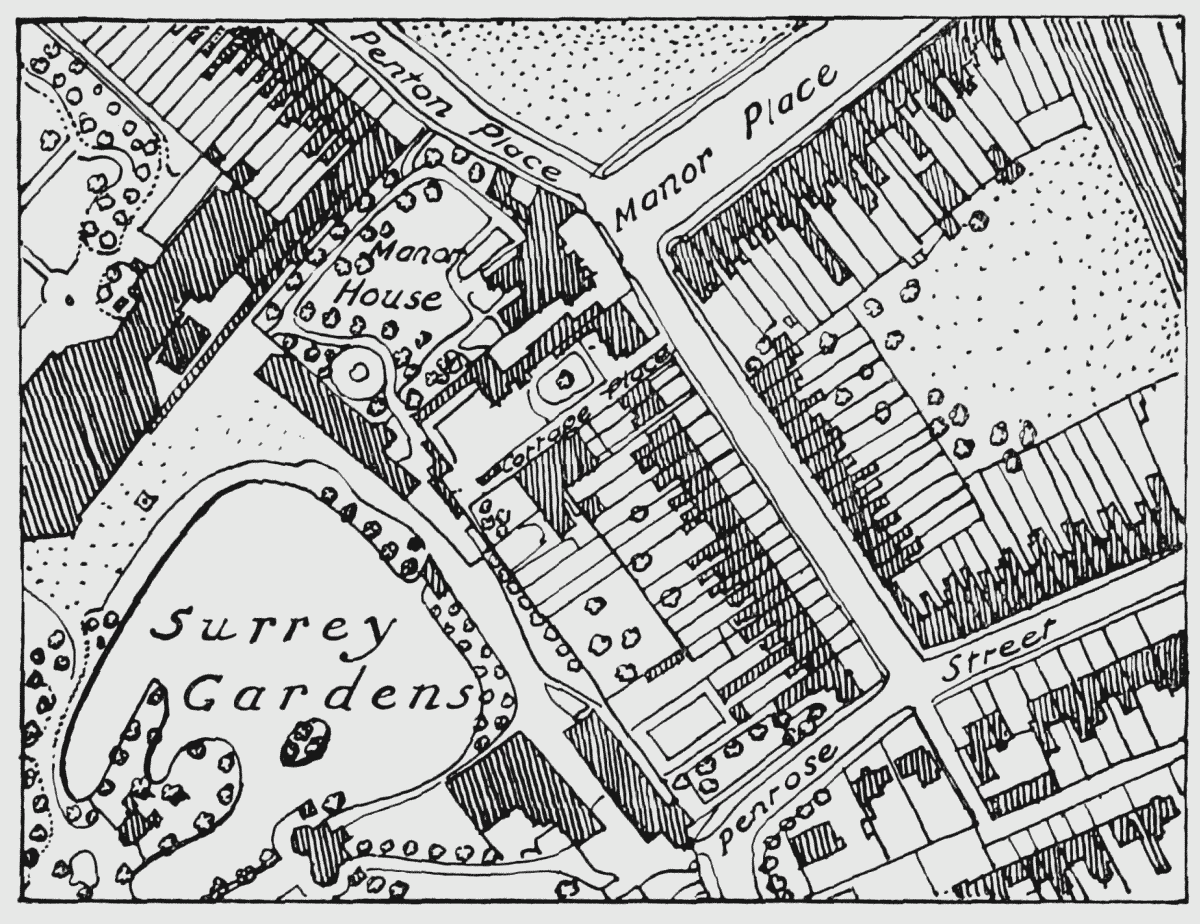
Map showing site of Walworth Manor House, etc. Based on the 1871 Ordnance Survey
Towards the middle of the century the gardens began to decline in popularity and they were sold by auction in 1856. The new proprietor built the Surrey Music Hall, designed by Horace Jones, on part of the grounds near the lake (Plate 59a). It held 10,000 people and, beside being used for concerts, it served as an auditorium for the Rev. Charles Spurgeon, who continued to draw crowds in spite of the accident, caused by a false alarm of fire, which occurred on 19th October, 1856, the first time he preached there (fn. 187) (see p. 104). The Music Hall was burnt down in 1861. It was rebuilt and, with the Manor House, served as a temporary home for St. Thomas' Hospital until 1871, when the present hospital on the Albert Embankment was opened.
An attempt to revive the Royal Surrey Gardens proved a failure, and in 1872 the 13 acres of "attractive pleasure grounds laid out with great taste in parterres, lawns, and terraces, adorned with Statuary and Fountains and interspersed with Gravel Walks, … and … a magnificent lake" was auctioned. The buildings included the theatre "substantially built of brick, with stone and compo ornamentation, corner Towers, handsome Balconies and Corridors," a brick-built bear pit and a new brick building intended for a menagerie (Plate 58b). (fn. 252) Streets of terraced houses were built over the whole area within the next two or three years by Sutton and Dudley, as lessees of Sir Thomas Hare and his trustees. (fn. n13) (fn. 256)
Lorrimore Square and Lorrimore Road
St. Paul's, Lorrimore Square, designed by Henry Jarvis in Victorian Gothic, on ground given by the Dean and Chapter of Canterbury, was completed and consecrated in 1856. The ground round the square was let in several lots to three builders, John Marsland of Walworth Road, John Lucas Allen of Finsbury Square, and John Abbott of Manor Road South, Newington, and the houses in the square were completed at about the same time as the church (Plate 84b). (fn. 257) The square was built on a close lying to the southwest of Lorrimore Common and not on the common itself.
On the south side of Lorrimore Road is St. Wilfred's Roman Catholic Church designed by Frederick Arthur Walters, and built in 1914. It is a substantial red brick building with a 60 foot battlemented tower surmounted by a short spire. (fn. 258)
Newington Crescent
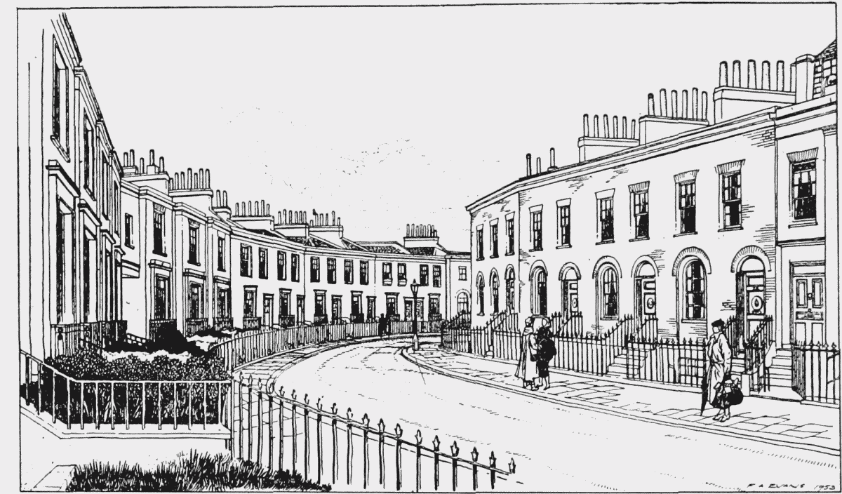
Newington Crescent, between Penton Place and Kennington Park Road, one of the few parts of Newington not absorbed into the Brandon Estate, was built in 1834–35. (fn. n14) It has no pretensions to distinction either of design or craftsmanship, yet the glimpse of a garden through the archway at the turn of the crescent, the simple lines of the elevation and the ironwork give some pleasure to the eye in an area of grimly utilitarian working-class dwellings. Henry Jarvis, the architect, was the first occupant of No. 8. (fn. 260)
Newington Crescent
Walworth Common
The ground on the east of Walworth Road at the southern end of the manor was open common land until 1769, when it was enclosed so that, in the words of the Act, it could be let for the benefit of the "numerous and expensive Poor" with which the parish was burdened. The ground was vested in trustees, who were empowered to let it on building leases for 99 years and to apply nine-tenths of the income to the relief of the poor, the remaining tenth being paid to the rector. A workhouse was erected and Westmoreland Road was laid out along the north side of the common, but except along the Walworth and Westmoreland Road frontages, there was little building there until after 1800. Development was not completed until after the passing of the Walworth Common Inclosure Amendment Act in 1851. (fn. 261)
Surrey Square
In 1766 Jane Driver, wife of Samuel Driver of the parish of St. George the Martyr, gardener, inherited some freehold land near the Kent Road from her uncle, Abraham Pursehouse, a well-known Quaker. (fn. 262) For part of this ground Michael Searles designed a terrace of houses (Plate 56), built in 1795–96, of which eighteen still survive, the present Nos. 20–54 Surrey Square. A square, or rather an oblong, of open ground was formally laid out in front of them, but Searles' drawing does not show whether it was intended to line the other three sides with buildings. Horwood's maps show two large houses on the west side of the square and one on the east. The latter was the home of William Driver, son of Jane and Samuel, from 1799 until his death in 1819. He left the house and its furniture to his wife, and Nos. 14, 5 and 6 (now 44, 26 and 28) in trust for his daughters Mary Ann, Caroline and Sophia respectively. (fn. 263) No further development took place until over sixty years later when the erection of All Saints' Church and the neighbouring houses entirely obscured the original configuration of the square.
Nos. 20–54 Surrey Square form the only remaining group of 18th century domestic buildings in Walworth with any pretension to architectural quality. The merit of the composition lies in its good proportions and simplicity of detail, the sole ornament being the fan motif in artificial stone in the pediment (Plate 57) and in the parapet of the end pavilion. Searles designed a doorway with a pedimented hood supported by Doric columns as an additional central feature, but this part of his design was not carried out (Plate 56).
Residents
Samuel Brandon was the first occupant of one of the houses (the former No. 22, pulled down in 1884 for Surrey Square School). No. 18 (formerly 1) Surrey Square was the vicarage of the church of St. Mary Magdalen, Massinger Street, during the second half of the 19th century. The church, which was consecrated in 1843, stood on ground purchased from the Driver family. (fn. 264) The Rev. John Waddington, minister of Union Street Chapel and the Pilgrim Church, Southwark, historian and sociologist, lived at No. 34 (formerly 9) Surrey Square in 1856–72. Samuel Palmer, the artist, was born at No. 42 (formerly 13) in 1805. (fn. 25)
Dickens Square
Unlike most parts of the Walworth Manor Estate, Dickens (formerly Union) Square (fn. n15) with the adjacent houses in Harper Road and Ralph Street, built on the close of 1 ac. 3 r. 15 per. shown on the 1681 plan (Plate 49) north of Horsemonger Lane, was planned as a unit by the Dean and Chapter of Canterbury and the Brandon Trustees. The actual work was carried out in 1844 by local builders—John Willson, John James, James Cooper and Richard Davis, William Broadbent (fn. n16) and Robert Davey Miller, James Seagrave, and George Richard Drinkwater—some of whose initials, together with D.C.C. (standing for the Dean and Chapter of Canterbury as ground landlords) are inscribed on stones inset in the groups of houses for which they were individually responsible. (fn. 265)
The two- and three-storeyed yellow brick terraced houses linked by cornices and by plain stone bands at first-floor level are in no way remarkable, and the central grass plot has been concreted over, but the square retains a quiet if decayed Dickensian aspect in an area now almost entirely given over to four-, five-, and six-storey blocks of flats. Perhaps its proximity to the slightly superior houses on the Trinity House Estate (fn. n17) has preserved it thus far, though plans for its redevelopment are now being considered by the London County Council.