Survey of London: Volume 25, St George's Fields (The Parishes of St. George the Martyr Southwark and St. Mary Newington). Originally published by London County Council, London, 1955.
This free content was digitised by double rekeying. All rights reserved.
'Tabard Street and the Old Kent Road', in Survey of London: Volume 25, St George's Fields (The Parishes of St. George the Martyr Southwark and St. Mary Newington), (London, 1955) pp. 121-126. British History Online https://www.british-history.ac.uk/survey-london/vol25/pp121-126 [accessed 26 April 2024]
In this section
CHAPTER 17: TABARD STREET AND THE OLD KENT ROAD, FORMERLY KENT STREET
The evidence suggests that Kent Street, the old road to Greenwich, Canterbury and Dover, was, like Borough High Street which it joined near St. George's Church, roughly on the alignment of a Roman road. The mediaeval road ran through open country, with no buildings except for an inn or two, and the Lock or Leper Hospital (see p. 124), which stood on the west side near the first milestone from London Bridge, at the point where the Lock stream, which formed part of Duffield's Sluice, crossed Kent Street. Only a small plot of ground was annexed to the hospital, but although leprosy was practically extinct in England by the beginning of the 17th century the memory of the lepers who used to wander in the neighbouring fields was preserved in their name of Lock (Locks) Fields until they were built over in the 19th century.
St. Thomas á Waterings, where a second stream, Earl's Sluice, crossed the road and where Chaucer's pilgrims halted to decide who should tell the first of the Canterbury Tales, was near the boundary between Southwark and Camberwell, approximately on the site of Shorncliffe Road. It was for several centuries a place of public execution. (fn. n1)
In 1565 an Act of Parliament (fn. 329) directed that Kent Street should be paved with hard stone as far as the Lock Hospital, and during the following century this part of the street was built up on both sides. In 1720 John Strype (fn. 20) described Kent Street as "ill Built, chiefly Inhabited by Broom Men, and Mumpers… here are divers large Yards wherein are vast Stocks of Birch, Heath and some only of Broom Staves which the Master Broom Men dispose of to those that make the Brooms." It is interesting to note that William Brandon, a trustee of the Brandon Estate in Walworth, was one of these small-scale 18th century capitalists (see p. 83).
As the 18th century wore on, the narrow courts and "old sorry Timber Houses" described by Strype degenerated into squalid rookeries and thieves' kitchens. After 1814 through traffic was diverted down Great Dover Street, and it was not until the middle of the century that any attempt was made to improve this part of Kent Street. It was re-named Tabard Street in 1877. (fn. n2) Most of the east side of the street was cleared in 1910 under a London County Council housing scheme; large blocks of dwellings were built and a small open space, Tabard Garden, was formed to give them breathing space.
Early in the 19th century the part of Kent Street south of the Lock Hospital, or Stone's End as it was sometimes called, became known as the Old Kent Road to differentiate it from the New Kent Road. Terraces of three-storey brick houses were built along the Southwark section of it between 1785 and 1820, but these were gradually converted to commercial use. Most of them have been pulled down, but Nos. 106–112 on the west side, formerly Nos. 1–4 Orford Row, built between 1787 and 1791 on land belonging to the Driver family (see p. 89), are still in good condition, though much altered. They are now in the occupation of Messrs. John Edgington, a firm of tent, flag and tarpaulin manufacturers (Plate 90). A Thomas Edgington moved to No. 108 in 1838 after a fire at his premises in another part of the Old Kent Road. (fn. 331)
No. 155, on the east side, is the Rolls Estate office, (fn. n3) designed by Michael Searles (fn. 332) and built in 1795 for his own occupation. It is a plain two-storeyed building with a steeply-pitched slate roof. The house retains its original railings with a lampholder at the centre of its frontage, and is known from its stucco facing as the White House. The decorative treatment of two of the mantelpieces and an internal door surround is shown on Plate 92. Michael Searles was surveyor to the Rolls Estate, as were his son and grandson after him. He lived in the house until his death in 1813, (fn. 333) and it continued in the occupation of his family until the death of his grandson, Robert Thomas Searles, in 1863.
The London County Council School for the Deaf, on the west side of the road between Mason Street and Townsend Street, stands on the site of the Asylum for the Deaf and Dumb, founded in 1792 by the Rev. J. Townsend of Jamaica Road, Bermondsey, Henry Thornton, M.P. for Southwark and the Rev. H. Cox Mason, Rector of Bermondsey. It was one of the earliest institutions in this country for the education of deaf children. The foundation stone of the building shown on Plate 91a was laid in 1807 by H.R.H. the Duke of Gloucester. The school was enlarged in 1819 and re-built in 1886–87. (fn. n4) The original boundary railings still remain with honeysuckle ornament to the gate standards.
The Lock Burial Ground, the Pilgrim Church and Buckenham Square
In 1659 Robert Shawe gave to the parish of St. George the Martyr a piece of pasture land in Lock Field just south of the Lock Hospital, in trust for the parish poor. Part of the ground was enclosed in 1711–12 and consecrated as a burial ground. In 1886 the Lock Burial Ground, having been long disused, was made into a recreation garden. (fn. n5) (fn. 336) The two stones set low in the brickwork fronting the Old Kent Road record that in 1792 a brick wall was erected round the burial ground at the sole expense of James Hedger, who was one of the parish trustees for the property. (fn. 96) (fn. c1)
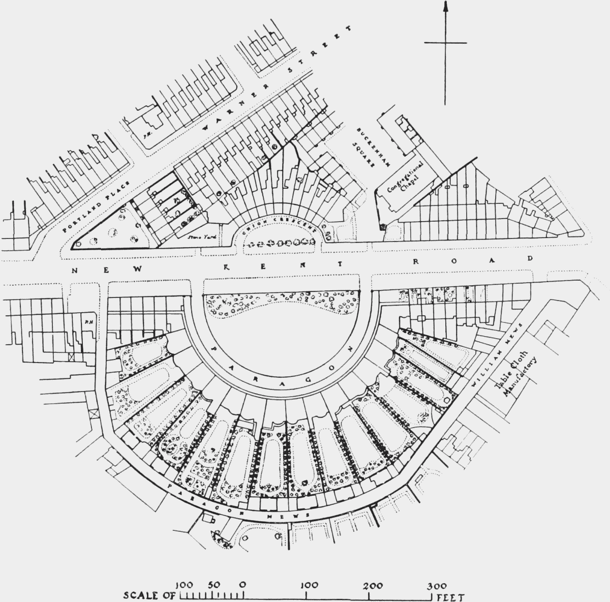
Section of 1872 Ordnance Survey
The Pilgrim Church in Buckenham Square was dedicated to the memory of the Pilgrim Fathers, a number of whom came from the Independent Congregational church in Southwark from which the Pilgrim Church traces its descent. A lease of the site was granted by the Trustees of Shawe's estate, and the church was opened in May, 1864, during the pastorate of Dr. John Waddington. The buildings were completely destroyed in December, 1940. Two communion cups of 1691 have survived. (fn. 337)
Houses were erected on the south side of Buckenham Street and in Buckenham Square on the rest of the parish's property, (fn. 336) but none have survived the heavy raids of the 1939–45 war.
Bartholomew Street (on the Site of the Lock Hospital)
The Lock or Leper Hospital in Kent Street was probably founded in the 12th century, though the first known reference to it occurs on the Patent Roll for 4th June, 1315, when protection for one year was given to the Master and Brethren of the hospital of St. Mary and St. Leonard, with their men and lands. (fn. 338) The City authorities were greatly concerned to keep lepers out of the City, and from 1375 onward they appointed two "formen" or wardens and surveyors, for the purpose, one at "le loke" and one at Hackney (i.e., at the two leper hospitals in Kent Street and Kingsland). (fn. 339) It is obvious that the hospitals, though they may have started as independent foundations assisted by alms from passers-by, derived considerable assistance and support from the City. They do not appear to have been surrendered at the Reformation, and in October, 1549, the Court of Aldermen ordained (fn. 340) that from thenceforth two aldermen and two commoners of the City, who should also be governors of the "house of the poore," i.e., St. Bartholomew's Hospital, should be appointed annually to be responsible for the "good governance & usyng" of the "Lazar howses nere adioynyng to this Citie wherof the Citie of Ryght hath the order." (fn. n6) Thenceforward there are numerous references to the Lock in the St. Bartholomew's Hospital Journals.
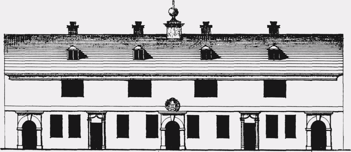
The wards and pledget room of the Lock Hospital
It has been suggested that the word "Lock" was used in this connection as being descriptive of the shreds or rags with which the sores of the lepers were covered. In the 18th century, when the hospital in Kent Street was no longer required for its original purpose, it became a refuge for patients suffering from venereal disease, and the term "Lock Hospital" came to be generally applied to hospitals treating that complaint. (fn. 341) In 1754 it was recommended to the Governors of St. Bartholomew's that both the Lock and Kingsland should be abolished, but they were not finally closed until 1760.
St. Bartholomew's Hospital
Among the records of the Surveyor of St. Bartholomew's Hospital is an elevation (reproduced on p. 124) and plan of the Lock Hospital made just before its closure. (fn. 342) The elevation is of the wards and "pledget" (fn. n7) room on the west side of the courtyard which lay north of the main buildings. The latter, consisting of the chapel, parlour, hall, kitchen and surgery, abutted directly on Kent Street, a little to the north of the bridge over the Lock Stream (shown on Rocque's map just north of the Bull Inn and the Lock Burial Ground).
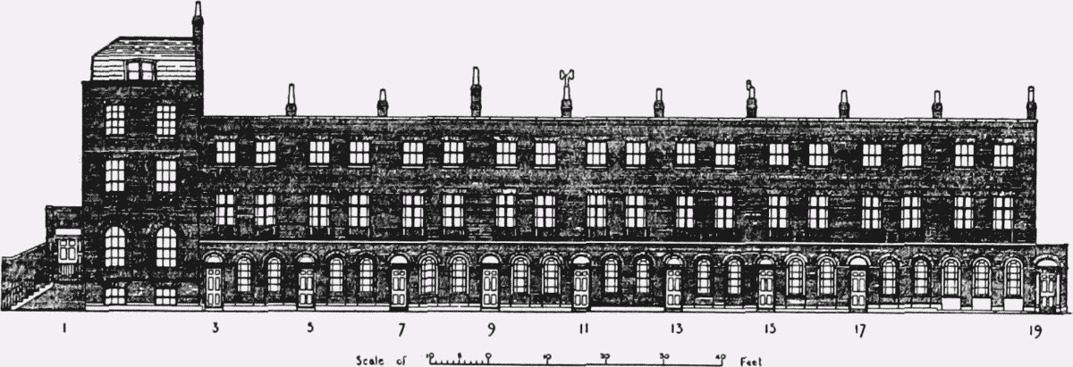
Nos. 1–19 Bartholomew Street
Four years after the Lock was closed the buildings were leased to William Hale (fn. 344) on condition that he spent £300 on them during the next two years. Part of the chapel and parlour survived until the formation of Great Dover Street, and are shown on an engraving published by Wilkinson in 1813 in use as dwelling-houses and a shop. The site of the hospital is the southern end of the tongue of land between Tabard Street and Great Dover Street and the roadway covers most of the site of the garden.
After the formation of Great Dover Street the Governors of St. Bartholomew's decided to develop the remainder of their Southwark property. A road was laid out running diagonally from the end of Great Dover Street to the New Kent Road (fn. n8) and the ground on either side was granted on building lease to George Davis of Dover Place in the Kent Road and Francis Hoad and John Wadey of Prospect Place, Southwark. (fn. 345) In accordance with the agreement to build fifteen houses there of the third rate, the terrace known first as Portland Place and now as Nos. 1–19 Bartholomew Street, was erected in 1818–19. Five houses were built on the south-east side of the street, of which two only, now numbered 233 and 235 New Kent Road, are left. They are similar in detail to those opposite, but as they have semibasements the entrances are approached from a raised paved way, the space beneath it being used as storage vaults.
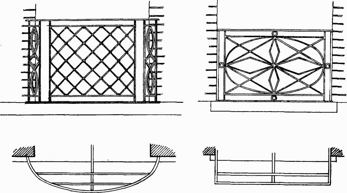
Bartholomew Street, balconies
Deverell Street
In 1828 a row of two-storey cottages was built in Deverell Street, a turning running at right angles to Bartholomew Street. All the houses between Deverell Street and Great Dover Street have been destroyed, though these cottages have survived the blitz practically unscathed, and the view from the windows must now be much as it was when they were new. The open site has, however, been purchased for the erection of London County Council flats.