A History of the County of Gloucester: Volume 8. Originally published by Victoria County History, London, 1968.
This free content was digitised by double rekeying. All rights reserved.
'The borough of Tewkesbury: Introduction', in A History of the County of Gloucester: Volume 8, ed. C R Elrington (London, 1968), British History Online https://www.british-history.ac.uk/vch/glos/vol8/pp110-118 [accessed 9 May 2025].
'The borough of Tewkesbury: Introduction', in A History of the County of Gloucester: Volume 8. Edited by C R Elrington (London, 1968), British History Online, accessed May 9, 2025, https://www.british-history.ac.uk/vch/glos/vol8/pp110-118.
"The borough of Tewkesbury: Introduction". A History of the County of Gloucester: Volume 8. Ed. C R Elrington (London, 1968), British History Online. Web. 9 May 2025. https://www.british-history.ac.uk/vch/glos/vol8/pp110-118.
THE BOROUGH OF TEWKESBURY
Tewkesbury, once a parliamentary borough, lies on the left bank of the Severn, a little below the point at which that river enters Gloucestershire. The town itself was outside the hundred (fn. 1) that took its origin and name from the large manor of Tewkesbury. (fn. 2) The parish of Tewkesbury, which since 1610 has been entirely within the bounds of the borough, (fn. 3) included the two rural areas of the Mythe on the north and Southwick on the south. The two areas were, in the Middle Ages, each a separate township and were included in the hundred; (fn. 4) later they were sometimes regarded as each comprising two townships, Mythe and Mythe Hook, and Southwick and Tewkesbury Park, (fn. 5) and the borough and the county disputed jurisdiction over them. (fn. 6) By the 19th century the whole of the parish and borough were treated as a single township, (fn. 7) presumably outside the hundred. The borough and parish of Tewkesbury as they existed before 1931 — the area that forms the subject of the account here printed — comprised 2,532 a. (fn. 8) In 1931 the area was enlarged by a net 82 a., gaining 133 a. from Ashchurch, 5 a. from Tredington, and 44 a. from Walton Cardiff, and losing 96 a. to Ashchurch and 4 a. to Stoke Orchard; (fn. 9) in 1965 the borough was further enlarged by the 150 a. of the Mitton housing estate, transferred from Bredon (Worcs.). (fn. 10) In shape the ancient parish was elongated and irregular. It stretched over 4 miles from north to south, broadening out from a narrow spit of land, Mythe Hook, (fn. 11) in the north to c. 2 miles across at the southern boundary. The River Severn marked the whole of the long western boundary; the eastern boundary followed in part the River Swilgate, the Carrant brook, and the River Avon, and part of the boundary of the Mythe and Mythe Hook followed small water-courses. (fn. 12)
The town was established near the confluence of the rivers Severn and Avon. Thus it was on a navigable waterway and on a prehistoric land-route between north and south-west England; it has been suggested that it was also on a route between eastern England and Wales. (fn. 13) The line of a supposedly Roman road can be followed through the Mythe immediately north of the town, and remains that were found within the town suggest occupation in the Romano-British period. (fn. 14) Immediately before the Norman Conquest Tewkesbury was the centre of a large agricultural estate, and no indication has survived of an urban character at that time. During the Conquest it was laid waste, to the extent that its value fell from £100 a year to £12, and 20 years later it had still not recovered its former value. In that period, however, William the Conqueror's queen, Maud, established 13 burgesses and a market there, (fn. 15) the earliest record of the town's function as a commercial centre. In 1102 Robert FitzHamon founded the Benedictine abbey of Tewkesbury, providing the other main feature of the town's history. (fn. 16)
In the 12th century FitzHamon's successors as lords of the honor of Gloucester had a seat at Tewkesbury, which in 1140 was burned by Waleran, Earl of Worcester, and his men. The monks persuaded the attackers to spare their property, (fn. 17) so that it is unlikely that the town itself suffered much damage. It may be presumed that the relatively frequent presence of the royal court at Tewkesbury in the 13th century helped the prosperity of the town. The most notable occasions were in 1204, when King John kept Christmas at Tewkesbury, (fn. 18) in 1236, when Henry III and Llywelyn ap Iorwerth made a truce there, (fn. 19) and in 1278, when Alexander III of Scotland offered his homage to Edward I. (fn. 20) Tewkesbury's function as a market centre in the Middle Ages, maintained by privileges granted in the 12th century, (fn. 21) is discussed below. (fn. 22) In 1324 the Crown made the first of a series of grants of pavage in the town, (fn. 23) and in 1327 there were 114 burgageholdings in the manor. (fn. 24) By the early 16th century the number had risen to 136, (fn. 25) and there were another 6 in the abbey's fee. (fn. 26)
From the 15th and 16th century, surviving buildings in the town show signs of local prosperity. In the 16th century this prosperity was stimulated by the dismemberment of two large estates controlling the town, for not only the abbey's estates but also those of the honor of Gloucester, known as Warwick's and Spencer's lands, (fn. 27) were divided and sold. The prosperity and perhaps also a growing self-consciousness were reflected in 1575 in the grant to the town, (fn. 28) which already had some of the characteristics of a corporate borough, (fn. 29) of a charter of incorporation. Another indication, perhaps, of the vigour and independence of the town was the strong current of religious nonconformity. In the late 16th century Camden noted that the town was famous for making woollen cloth and mustard; (fn. 30) a century later another visitor recorded Tewkesbury as 'a large town . . . well furnished with all sorts of provisions; . . . drives a considerable trade in clothing and is noted for its mustard balls.' (fn. 31)
In the early 18th century it was recorded that the woollen manufacture had declined, and that in an attempt to employ the poor who were thrown out of work the leading inhabitants 'set the poor to knitting of woollen and cotton hose, caps, gloves, breeches, and other such like things, by which means ... it is now become a very wealthy and populous place.' (fn. 32) The change was perhaps neither so sudden nor so profound as is there suggested. In 1705 Defoe recorded 'a quiet trading drunken town, a Whig baily and all well'; (fn. 33) and not only did the manufacture of cloth survive until the later 18th century, but besides knitting the town had other major industries, particularly malting and the production of leather, and also an important place in the corn trade and the traffic on the River Severn. These and other industries and trades are mentioned in more detail below; (fn. 34) they combined to give the town a clear appearance of prosperity — 'a very handsome [town] consisting of one very long and open well paved street' in 1746, (fn. 35) 'a large, beautiful, and populous town, of which the chief manufacture is woollen cloth and stockings' in 1774. (fn. 36) A writer in the early 19th century ranked Tewkesbury next after the county town, (fn. 37) and whereas in the 14th century Tewkesbury was a humbler place than Cirencester, (fn. 38) by 1608 it had easily overtaken Cirencester. (fn. 39)
Although Tewkesbury manufacturers built factories there in the 19th century, the development of factory-based industries in towns closer to the sources of power started the decline in Tewkesbury's industrial fortunes. A report of 1835, while recording that the 'town appeared to be in a thriving state', noted some of the symptoms of this decline. (fn. 40) The next year Tewkesbury lost further ground when the Gloucester & Birmingham Railway Co. decided to build their line not through Tewkesbury but 2 miles to the east, on an easier route for the approach to Cheltenham. The branch line to Tewkesbury, a sop to the town's opposition to the proposed route, (fn. 41) could not make up for the absence of a main line, and in 1841 a local writer described railways as an unmixed evil for Tewkesbury. (fn. 42) In 1850 an inspector reported to the General Board of Health that the town's population was stationary, the mortality rate unusually high, and the sanitary conditions appalling. (fn. 43) The main problem was the physical structure of the town. Sixty years earlier a writer describing the town as 'large, beautiful, and populous' had gone on to say that it was made up of 'three well built streets and many lanes.' (fn. 44) Most of the lanes were not so much lanes as alleys; in the mid-19th century there were over 100 lanes, alleys, and courts (fn. 45) only a few feet wide leading off the three main streets that met at the centre of the town. The alleys and courts were horribly overcrowded: (fn. 46) it is to be observed that with few of them demolished or altogether deserted, and the built-up area of the town more than doubled by the building of new housing estates, the population in 1961 was marginally smaller than in 1851. (fn. 47)
In the later 19th century a fall in population accompanied the decline and disappearance of the traditional industries of the town. Economic stagnation in that period was not wholly without compensating advantages, for in the absence of urban redevelopment the appearance of the streets survived relatively unaltered until extensive demolition and rebuilding began in the 1960's. Tewkesbury remained a market town, but one that was no longer on a main line of communication. One industry that continued to prosper was light engineering, and its survival accompanied the establishment of the large engineering works at Ashchurch, Tewkesbury's eastern neighbour, in the mid-20th century. In 1964 the provision of houses, schools, shops, and other social amenities for the work-people of Ashchurch and their families was a more important part of Tewkesbury's function than the smaller industries of the town itself — engineering, milling, and, through the presence of the 12th-century abbey church and the many picturesque timber-framed houses, tourism.
Particular aspects of the history thus briefly outlined are covered below under appropriate headings, in greater detail.
The physical characteristics of the landscape are dominated by the rivers and streams. The ridge of Keuper Marl running due south through Tewkesbury is divided by the Avon and the Swilgate into three pieces, large ones north and south, forming respectively the Mythe and Southwick, and a small one in the middle, on which the town is built. Southwick is further sub-divided into two north-south ridges by the Southwick brook. The land rises in both the Mythe and Southwick to over 100 ft. In the Mythe the steep red cliff of the Mythe Tute, also called Royal Hill because the view from it pleased George III and his queen, (fn. 48) shows where the Severn has cut into the marl; in Southwick the higher ground is partly overlaid by the Rhaetic beds; and in both there are stretches of Lower Lias. Along the Severn, the Avon, and the Swilgate is alluvial meadow-land, and the great meadow called Severn Ham, covering c. 200 a. and dividing the town from the Severn, is a striking feature of the landscape. The long stretch of meadow-land that forms the Mythe Hook is also extensive; adjoining it and perhaps covering part of it in the 13th century was the Mythe Wood, (fn. 49) of which 80 a. survived in 1612. (fn. 50) In 1327 the Abbot and Convent of Tewkesbury were licensed to impark their wood of Mythe, (fn. 51) and in 1540 there was a warden of the wood with a house called the Lodge. (fn. 52) South of the town Tewkesbury Park was being inclosed in 1185 and 1187. (fn. 53) In 1214 Jordan the parker held land by the service of custody of the park. (fn. 54) Brushwood and charcoal were produced from the park in 1232, (fn. 55) and there was a quarry there in 1526. (fn. 56) Deer were sent to stock the park in 1238, and the park provided bucks in 1240. (fn. 57) In 1296 it covered 200 a., (fn. 58) and in 1540 it comprised 80 a. and held 300 deer. (fn. 59) The office of parker, which by the late 15th century was held with that of bailiff of the liberty or hundred of Tewkesbury, (fn. 60) included the keeping of a lodge in the park. (fn. 61) After the 16th century no reference has been found to the park as a deer-park; it formed the estate centred on the house called Tewkesbury Lodge or Tewkesbury Park. (fn. 62)
Part of the Mythe and tracts of land in Southwick south and north-east of the park were once openfield arable. Some arable land in Southwick remained uninclosed in 1686, and until 1811 there was a small open field called Oldbury field immediately east of the town. Most of the land of the parish, however, has for centuries been grass-land. (fn. 63)
The rivers and streams not only determine the nature of the landscape but have themselves been a significant element in the history of Tewkesbury. Most important has been the function of the Severn, and to a lesser extent of the Avon, as an artery of communication, which is discussed below. (fn. 64) Fishing in the rivers, which in 1964 remained a popular pastime, for long provided a livelihood for some inhabitants. Domesday records a fishery at Tewkesbury, (fn. 65) and in 1205 the fishery produced salmon and lampreys for the Crown. (fn. 66) In the same period large numbers of bream were kept in the fishponds of Tewkesbury, (fn. 67) perhaps in the large moat-like works supplied with water by the River Swilgate; (fn. 68) the outlines of those fishponds were visible until 1964, when the borough council was filling them to provide land for playing-fields. (fn. 69) In the 13th and 14th centuries several fishermen of Tewkesbury were recorded, (fn. 70) and in 1307 the honor of Gloucester had eight fishing tenants at the Mythe. (fn. 71) Two fishermen figured among the inhabitants of the town in 1608 (fn. 72) and seven in 1773. (fn. 73)
Tewkesbury Abbey acquired a fishery in the Severn and Avon early in the 12th century, (fn. 74) and in 1292 a stone weir in the Severn belonging to the abbot had to be destroyed because it obstructed shipping. (fn. 75) It may have been not so much destroyed as broached with a lock, (fn. 76) but the abbey's stone weir recorded in 1398 (fn. 77) may not have been in the Severn. In 1327 there was possibly a weir at the Mythe in the Avon, (fn. 78) and it has been suggested that the abbey's weir at which two servants were employed in 1386 was in the Swilgate. (fn. 79) The last weir may, however, have been in the Mill Avon.
The date at which the Mill Avon was made is uncertain. The Avon originally turned sharply westward above Tewkesbury to join the Severn above the bend at the Upper Lode. An artificial watercourse was made along the north-west side of the town to connect with the River Swilgate ½ mile above its confluence with the Severn, and along this cut some of the Avon's water was diverted. The rest of the water reached the old course through the weirs which emptied into the Stanchard Pit and the Quay Pit. The part of the Mill Avon below t..e Abbey Mills was straightened during the Second World War; (fn. 80) the meanders had presumably been caused by the flow of water through the mill-races and adjoining weir. The conjecture that the Mill Avon was made in the 15th century by the Duke of Clarence (fn. 81) appears to stem from the belief that it was defensive; it was perhaps encouraged by the fact that the cut marks the north-west edge of the town and by association with the Battle of Tewkesbury in 1471. It is more likely that the Mill Avon was made purely to drive mills, possibly in the 12th century. The mills granted to the abbey at its foundation seem to have been on the cut; the abbey mills recorded in 1535 certainly were, and they appear to be identical with the abbot's mills recorded in 1291. (fn. 82)
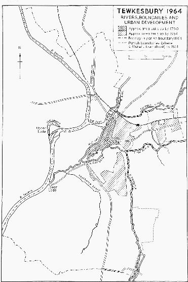
Tewkesbury, 1964
Other changes in the river-system were made to improve navigation. In 1583 the quay at the Quay Pit was newly paved. (fn. 83) The quay was recorded in 1407, and in 1519 money was given for its repair. (fn. 84) In 1636 and 1637, in spite of opposition from people living higher up the Severn, (fn. 85) William Sandys of Fladbury (Worcs.) made the Avon navigable, (fn. 86) effecting the junction with the Severn by means of the double sluice mentioned a few years later. (fn. 87) The sluice was perhaps in the same position as the lock that survived in 1964 between the Quay Pit and the Mill Avon. The Avon navigation was regulated by an Act of 1751. (fn. 88) Navigation on the Severn remained unrestricted and unaided by any Act or improvement until 1842. (fn. 89) Dredging and works effected elsewhere under the Act of the year left Tewkesbury quay high and dry, (fn. 90) emptied the basin, and cut communication between the Severn and Avon. (fn. 91) Under an Act of 1853 (fn. 92) new works were begun at the Upper Lode in 1856, comprising a new channel cutting across the sharpest part of the bend, with a weir, lock, and basin. (fn. 93) The new works were opened in 1857 and finished in 1858; (fn. 94) the old channel was blocked off.
The rivers' flooding limited the physical expansion of the town, and also provided a frequently recurring hazard for the inhabitants. Severe floods were recorded in 1484, 1587, (fn. 95) 1611, (fn. 96) and 1673, when the water came up to the gutter of the Bull Ring. The years 1652 and 1653 were remarkable for having no floods, either summer or winter. (fn. 97) In 1678 it was said that in flood time the rivers made an island of the church end of the town, and in very high floods entered the church. (fn. 98) During the summer floods of 1721 it was possible to row in a boat about the town; (fn. 99) in 1770 floodwater entirely covered the lower stories of houses in St. Mary's Lane, (fn. 100) in 1814 people sailed boats completely around the town, (fn. 101) and houses were again badly flooded in 1853. (fn. 102) In 1947 the Severn Ham was under 6 ft. of water, (fn. 103) and in 1960 the town was surrounded by water except where the main roads left it. (fn. 104) The freezing of the Severn, so that it was closed to shipping, and would bear people, horses, and waggons, was less troublesome and less frequent; such freezing was recorded in 1607–8, (fn. 105) 1739–40, 1776, (fn. 106) and 1814. On the last occasion the men who hauled trows up the river took to hauling fuel by land from the Forest of Dean, and the ladies of Tewkesbury made the river (which because of its sheltering banks was warmer than the roads) their 'fashionable promenade'. (fn. 107) In 1963 the Avon froze hard, and a car was driven along it. (fn. 108)
The rivers among which Tewkesbury lies were a considerable obstacle to land communications, and to some extent the town's situation near places at which it was possible to cross the rivers, especially the Avon, but also the Swilgate and the other streams, was responsible for its growth. The Avon was the largest river crossing on the ancient route running down the left bank of the Severn. Tradition relates that the bridge across the Avon was built by King John, and certainly in 1205 the bailiff of Tewkesbury was to have two oaks for making a bridge. (fn. 109) The first record of the tradition suggests that John built the bridge before his accession to the throne. (fn. 110) The name King John's Bridge did not become current until the 19th century; earlier it was called the Long Bridge (fn. 111) or, in the Middle Ages, the bridge towards Mythe, (fn. 112) and it may have been the Wide Bridge after which an inhabitant of the town in 1321 was named. (fn. 113) Once the Mill Avon had been made there was not one bridge but two, and the roadway between the two and beyond them was at various times carried on a land bridge instead of a solid causeway. (fn. 114)
Leland said that King John gave the town the tolls of the Wednesday and Saturday markets for the repair of the bridge, which the town neglected. (fn. 115) In 1368 the town acknowledged that it was responsible for the repair of the bridge, the north part of which was broken; (fn. 116) in 1530 all the tenants of the Mythe were obliged to partake in the repair of the bridge. (fn. 117) An attempt in 1621 to make the bridge the county's responsibility was unsuccessful, (fn. 118) and in 1638 the county raised money for the repair on the understanding that the town would be responsible for all future maintenance. (fn. 119) The town looked after the bridge (fn. 120) until 1891 when, after disputes between the town and the county, the county adopted it as a county bridge. (fn. 121)
In the early 16th century the bridge was a series of stone arches spanning both arms of the Avon, with, apparently, an extension carried across the Avon Ham on a wooden structure. (fn. 122) The bridge was repaired in 1407, (fn. 123) 1588, (fn. 124) 1639, and 1650; the repairs of 1639 appear to have been substantial, (fn. 125) and may have included filling in the arches between the two arms of the Avon, for in 1675 there were two distinct stone bridges, one of three and the other of two stone arches. (fn. 126) The bridge was again repaired in 1710, (fn. 127) and in 1747, after strong river currents had damaged it, the arches over the Old Avon were renewed and three wooden spans 'next the Avon' (apparently the land bridge) were replaced by four brick arches. (fn. 128) In 1756 the bridge, (fn. 129) and in 1810 the causeway beyond the Old Avon, were widened and raised, and in 1824 the whole roadway was raised. (fn. 130) In 1836 the bridge over the Old Avon was widened by adding a footpath on cantilevered iron brackets. (fn. 131) The resulting bridge, as it existed in the early 20th century, was a miscellaneous collection of stone and brick arches on stone piers, with brick parapets, an iron sidewalk, and a roadway as narrow as 16 ft. in places. There were four arches over the Mill Avon, six over the Old Avon, and seven between the two. (fn. 132) The whole was rebuilt in stone and concrete, retaining some of the old features, and opened in 1962 as two distinct bridges, King John's Bridge over the Mill Avon and Beaufort Bridge over the Old Avon. (fn. 133)
At the other end of the town Holm Bridge (later Swilgate Bridge) over the Swilgate was mentioned in 1540. (fn. 134) Welaker Bridge, named in 1482, (fn. 135) may have been the same or a bridge across the Southwick brook in Bloody Meadow. Holm Bridge was repaired in 1588; (fn. 136) it is said to have been a drawbridge until 1635, when it was rebuilt (fn. 137) in stone. (fn. 138) It was repaired in 1750, and widened and raised in 1756 (fn. 139) and 1827. (fn. 140) A little further up the Swilgate the Gander Lane Bridge was apparently recorded in 1540, as Priests' Bridge. (fn. 141) There was a wooden footbridge there from 1602 until 1791, when it was replaced by a stone bridge. (fn. 142) A third bridge over the Swilgate, perhaps on the site of the footbridge a short way above the Gander Lane Bridge in 1964, was mentioned in 1575. (fn. 143)
The bridge at the north end of the town across the Carrant brook was called Carrant Bridge in 1592. (fn. 144) It was widened and raised in 1756, (fn. 145) and again widened in 1833. (fn. 146) Salandine's Bridge, over the small tributary of the Carrant brook on the former boundary between Tewkesbury and Ashchurch, existed by 1519 (fn. 147) and was to be repaired by the town in 1543. (fn. 148) It was a stone bridge in 1574, (fn. 149) was raised in 1756, (fn. 150) improved in 1824, (fn. 151) and widened in 1835. (fn. 152) Improvements to the main road there in the 20th century have made Salandine's Bridge almost imperceptible to the casual passer. Another ancient bridge in Tewkesbury was Quay Bridge, necessary for access to the town quay once the Mill Avon had been made. The bridge was mentioned in 1733; (fn. 153) the old stone bridge that was replaced by an iron bridge in 1822, under an Act of 1808, was thought to be 350 years old. (fn. 154) The iron bridge survived in 1964.
There was no bridge across the Severn near Tewkesbury until the 19th century. Earlier there were two ferries, the Upper Lode on the crown of the river's bend round Severn Ham and the Lower Lode just below the confluence of the Swilgate (and the Mill Avon) with the Severn. Both ferries belonged to Tewkesbury Abbey, and the Lower Lode ferry provided a link between the abbey and its estate at Forthampton. (fn. 155) The Upper Lode was evidently the ferry recorded in 1248 as 'Wulmareslode', (fn. 156) and is likely to be that to which John atte Lode in 1385 (fn. 157) and John Donne the ferryman in 1450 (fn. 158) belonged. In 1540 there was at the Upper Lode an old barge of 6 doles burden, and an old boat called the stockboat, double-prowed and with various gear; the passage-house had a hall, chambers, cow-house, and barn, and there was also a warehouse. The abbey's farmer of the Upper Lode was obliged to carry passengers across the river, (fn. 159) but whether or not the passengers had to pay is not clear. In 1564 the Crown granted the ferry in fee to William Wyatt, (fn. 160) whose successor John Wyatt sold the ferry in 1610. (fn. 161) By 1676 the Upper Lode was in the hands of the Dowdeswell family of Pull Court in Bushley (Worcs.), (fn. 162) and the Dowdeswells retained it until 1826, when the ferry stopped working on the opening of the Mythe Bridge. (fn. 163)
The Mythe Bridge was begun in 1823 under an Act of Parliament. After disagreements with their original architect, George Moneypenny, the trustees called in Thomas Telford, who replaced the plan for a bridge of three cast-iron arches with one for a single large cast-iron arch. The arch, with a span of 170 ft., rise of 17 ft., and width of 27 ft., came from William Hazledine's foundry in Worcester. A feature of the bridge are the tall, narrow Gothic arches of the stone abutments, which give a light appearance and allow the passage of flood-waters. The bridge was opened in 1826, (fn. 164) and was freed from tolls in 1891. (fn. 165) It was afterwards maintained by Gloucestershire and Worcestershire jointly; (fn. 166) in 1923 it was strengthened by laying a reinforced concrete slab over the decking. (fn. 167)
The roads carried by the bridges were often in bad condition because they were low-lying and liable to flood. In the late Middle Ages bequests for the maintenance of the roads were frequent, specifying 'the four highways attaining to the town of Tewkesbury' (fn. 168) or 'the four great roads next Tewkesbury'. (fn. 169) These were the road over the Long Bridge northwards, the road leading east out of the town (Salandine's Way), (fn. 170) and the two roads leading south from Holm Bridge; the road leading north-east from the Carrant Bridge was evidently of minor importance. South of Holm Bridge the road forked: the western road, which in 1964 led only to the Lower Lode, was the usual one to Gloucester, rather than the eastern road which led past Gubshill (fn. 171) and along the ridge towards Cheltenham. (fn. 172) In the Mythe the main road north turned north-west from the top of Mythe Hill, down Paget's Lane towards Bow Bridge in Twyning; that may have been the packway called Kyvehull Lane in 1531, (fn. 173) and it was the route the main road followed until c. 1750. (fn. 174)
The four main roads mentioned above, together with the road over the Carrant Bridge, were the subject of a turnpike Act in 1726, (fn. 175) after an attempt in 1721 to turnpike the main road to the east (fn. 176) had failed. The Act of 1726 was apparently allowed to lapse after its term of 21 years; a new Act was the main issue in the parliamentary election of 1754, and the two members returned for Tewkesbury were said to owe their election to their undertakings to contribute large sums (£3,000 together) towards the cost of new roads. (fn. 177) The new Act was passed in 1755, and the same year work was begun on building the road to Cheltenham. (fn. 178) The length of road under the 1755 Act was greater than under the 1726 Act, but the roads leading out of Tewkesbury were the same except that the main road north went over Shuthonger Common to Twyning. (fn. 179) The state of the roads leading east and south of the town remained unsatisfactory: in 1777 an attempt was made to improve the Ashchurch road by raising a subscription, and in 1792 a road club was formed. (fn. 180) The turnpike trustees achieved more success in the early 19th century, apparently as the result of a change in policy and the abandonment, under an Act of 1818, of the road beside the Severn beyond the Lower Lode. (fn. 181) Stone for the Tewkesbury roads was brought up river from the Bristol area, and major improvements were made to the main road through Southwick and up the Mythe Hill. In 1830 a local writer referred to the 'unrivalled state' of the turnpike roads, (fn. 182) and another recorded that the roads were excellent and the tolls modest. (fn. 183) In 1830, with the new facilities provided by the Mythe Bridge, Tewkesbury was a busy centre of road traffic: there were two large posting-houses — the 'Swan' and the 'Hop Pole' — and 30 or more stage coaches passed each day through the town. (fn. 184)
A branch railway from the main line at Ashchurch was built under an Act of 1837 (fn. 185) and opened in 1840. Until 1844, when the branch was extended to the Quay, the carriages were drawn to and from Ashchurch not by steam-engines but by horses. (fn. 186) In the same period Tewkesbury was losing its former coach traffic, and in 1845 the diversion of the LondonHereford mail to the route through Gloucester and Ledbury deprived Tewkesbury of its last four-horse coach. (fn. 187) In 1861 the Malvern & Tewkesbury Railway was built (fn. 188) from the Tewkesbury branch through the Mythe, passing by a short tunnel under the Mythe Tute. It crossed the Avon by a cast-iron bridge designed by William Moorsom. (fn. 189) The station on the new line became Tewkesbury's passenger station, and the branch station became the goods depot. Passenger services were withdrawn from both lines in 1961; the permanent way across the Mythe was removed in 1964, and in the same year goods services between Tewkesbury and Ashchurch were withdrawn. (fn. 190)
Royal visits to Tewkesbury in the 13th century and the military episode in the 12th have already been mentioned. There was further violence in 1265, when the townspeople killed Welshmen fleeing after the battle of Evesham in great numbers. (fn. 191) In 1367 the abbey church had to be reconciled after bloodshed there in the course of disputes between the townspeople and the abbey about tithes and oblations: the townsmen went about in armed bands, threatening violence to the abbot and monks. (fn. 192) Reconciliation of the church in 1470 after more bloodshed there is also recorded, (fn. 193) but a mistake in the year is possible, and the reconciliation may have followed the battle of Tewkesbury in 1471.
The battle of Tewkesbury, which ended the Lancastrians' attempt to overthrow Edward IV, was fought at the southern approaches to the town, between the Swilgate and the Southwick brook. (fn. 194) The Lancastrian army made its stand on the ridge between the two; the reason why it did not pass through the town and either cross the Severn or defend the much better defensive position on the Mythe Hill, with the Avon between it and Edward IV's advancing forces, may have been opposition from within the town, (fn. 195) of which the Duke of Clarence, by then restored to Edward's party, (fn. 196) had recently become lord. (fn. 197) The battle has remained important in local tradition: the graves of the more distinguished dead are in the abbey church; Battleham and Bloody Meadow are allegedly the places where the fight was fiercest and the slaughter most savage; the moated site near Gubshill manor-house, where Queen Margaret is imagined to have passed the night before the battle, is known as 'Margaret's Camp'; an obelisk recording the battle and other events was put up in 1932; houses in the town have been given names associating them with the leaders of the two armies; and the same leaders have provided names for the roads of the 20th-century housing estate near the site of the battle.
In 1526 the Princess Mary passed some time in the town, (fn. 198) and in 1535 the king himself was there. (fn. 199) In addition to the royal visits mentioned above, Richard II stayed some time at Tewkesbury during the parliament held at Gloucester in 1378. (fn. 200) George III, in the course of his stay at Cheltenham in 1788, visited Tewkesbury several times to admire the view from the Mythe Tute, up which on one occasion he and the queen scrambled on hands and knees. (fn. 201) Minor local events more alarming to the inhabitants were prodigious swarms of insects in 1576 and 1681, (fn. 202) the strange appearance in the 17th century of enormous numbers of dead bats floating inches deep down the Avon, (fn. 203) and a snow-storm in 1634 fatal in its size and suddenness. (fn. 204) County assizes were held in Tewkesbury in 1579 and 1637. (fn. 205)
In the early years of the Civil Wars Tewkesbury saw much action and frequent changes. The town appears to have been predominantly for the parliament: in later years a number of inhabitants were fined as delinquents, (fn. 206) and in February 1643 the governor appointed by the Crown removed the arms of the town, which had held a magazine, (fn. 207) and of the townsmen. Between then and April the town changed hands four times: (fn. 208) Prince Maurice had crossed the Severn there by a pontoon bridge, pursuing Waller into Wales, but Waller doubled back, routed the royalist garrison of 300, and cut the bridge. (fn. 209) In June the parliamentary garrison of 1,000 horse and foot withdrew to Gloucester, having made the defensive works at Tewkesbury 'unuseful, though not fully slighted.' (fn. 210) In September, after raising the king's siege of Gloucester, Essex's force moved to Tewkesbury before marching back to London; (fn. 211) shortly afterwards the town was garrisoned for the king by a force of 400 Welsh foot who would not stay there, (fn. 212) but later that winter a fresh royalist force arrived. In 1644 the parliamentary army regained the town, (fn. 213) and held it with 300 men against threats from the king. Later in the year it was at Tewkesbury that Massey ferried his men across the Severn to intercept the royalist army. (fn. 214) In 1646 the House of Commons ordered that the garrison at Tewkesbury was to be slighted and the officers and soldiers there were to be disbanded or reduced in numbers. (fn. 215)
Disturbances in the later history of Tewkesbury have been few and of minor importance. A riot is recorded in 1714, on the night of George I's coronation. (fn. 216) In 1795, with more apparent cause and motive, a mob of women rioted on the quay, seizing a quantity of flour to prevent its being sent off by water. (fn. 217) In the next 20 years high prices and the depressed state of the hosiery industry caused some unrest in the town, and in 1814 James Kingsbury, a hosier, was threatened with murder if he did not raise the wages he paid. (fn. 218) In 1831 troops were called in and special constables appointed because of unrest in the hosiery industry, (fn. 219) but there was no riot; (fn. 220) an attack by a mob on the recorder and magistrates in 1831 appears to have been insulting rather than disturbing. (fn. 221)
The earliest of Tewkesbury's worthies, and the furthest from authentic record, is the legendary hermit and founder of the town, Theocus. The Jew of Tewkesbury, who died because he would not be pulled out of a cess-pit on Saturday and could not be on Sunday, occurs in literature rather earlier, in the 12th century, though most versions of the story, by linking him with Gilbert de Clare, the 'Red Earl', place him in the later 13th century; (fn. 222) Leland's reference to 'the Jew at Tewkesbury' (fn. 223) is presumably to this story, and a traditional association may be reflected in the statement published in 1712 that there was no male Jew in Gloucestershire and a solitary Jewess living in Tewkesbury. (fn. 224) In 1685 a Tewkesbury cordwainer described as a Jew was buried at Oxenton. (fn. 225) In fictional literature the town figures prominently in Mrs. Craik's John Halifax, Gentleman, (fn. 226) and incidentally in The Pickwick Papers. (fn. 227) The town itself is the chief character, lightly disguised, of A Portrait of Elmbury, (fn. 228) one of a series of books evocative of the locality, whose author, John Moore, represents a family that for long practised several professions in Tewkesbury, was prominent in local affairs from the early 18th century, (fn. 229) and was perhaps settled there by 1610, when Thomas Moore was admitted a member of the cordwainers' guild. (fn. 230)
Natives of the town include John Ward (fl. 1642–3), the puritan poet, Richard Estcourt (1688– 1712), the actor and playwright, Sir John Easthope (1784–1865), the politician and journalist, and, presumably, Alan of Tewkesbury, the contemporary and biographer of St. Thomas Becket. (fn. 231) The freedom of the borough has been conferred on Thomas Collins, a builder and architect of Tewkesbury in the later 19th century, on George William Coventry, Earl of Coventry (d. 1930), the seventh of his line to serve the office of steward of the borough, (fn. 232) and (in 1964) on Sir George Dowty, the industrialist. (fn. 233) Many other people of note who were connected with Tewkesbury are mentioned elsewhere in this account; here it is fitting to single out James Bennett, a local printer, who in 1830, enlarging on the earlier work of his fellow printer William Dyde, (fn. 234) published a history of Tewkesbury which, over the next 19 years, he brought up to date and supplemented in annual issues. (fn. 235)